March 7, Attoyac Bayou Watershed Protection Plan Sarah Fuller, SFASU Arthur Temple College of Forestry
|
|
|
- Eric Shepherd
- 5 years ago
- Views:
Transcription
1 March 7, 2013 Attoyac Bayou Watershed Protection Plan Sarah Fuller, SFASU Arthur Temple College of Forestry 1
2 Used to assess the physical, chemical, biological, and economic factors affecting attainment of water body use Identify and assign attainable uses and criteria to water bodies Ultimate purpose is to establish the most suitable water quality standard for individual bodies of water taking into consideration its unique features 2

 Non-contact recreation 2,060")
3 Pre 2010 standards Two recreational categories Primary contact Non-contact 2010 water quality standard revisions 4 categories of water quality contact and standards Primary contact recreation 126 (colonies/100ml) Secondary contact recreation (colonies/100ml) Secondary contact recreation2 1,030 (colonies/100ml) Non-contact recreation 2,060 (colonies/100ml) 3


4 Primary contact recreation Recreation involving a significant risk of ingestion of water 4


5 Secondary contact recreation 1 Recreation with limited incidental body contact not involving a significant risk of water ingestion 5
 physical characteristics of the water body and/or (b) limited public access 6")
6 Secondary contact recreation 2 Recreation activities with limited incidental body contact not involving a significant risk of water ingestion but that occur less frequently than for secondary contact recreation 1 due to (a) physical characteristics of the water body and/or (b) limited public access 6


7 Non-contact recreation Activities near a body of water not involving a significant risk of water ingestion, and where primary and secondary contact recreation should not occur because of unsafe conditions 7
8 Forty-four (44) sites were selected for the Attoyac Bayou comprehensive RUAA survey 36 sites : public access 1 public location, landowner retracted permission 8 sites : private property Conducted during a warm season (temp >70 ), during dry weather flows Survey 1: July 20-22, 2012 Survey 2: August 24-25,
9 9
10 November 28, 1975 to the present day Historical societies, community members, museums, government officials, newspapers, recreational service providers, as well as general internet searches regarding the watershed. 10
11 East Texas Research Center Ralph W. Steen Library Final Environmental Impact Statement: Attoyac Bayou Watershed, 1980 Recreational needs for the northern Nacogdoches County towns of Garrison, Cushing, and Appleby are not being met because of an uneven distribution of the surface water and water-based recreational facilities (p 38). Newspapers Austin American-Statesman, July 18, 2010 Using the Old Noodle The Houston Chronicle, December 12, 1997 Tips on Finding Bass in the Cold The Houston Chronicle, March 6, 2008 Lone Star Anglers Can Cash in Big During the Spawning Season for White Bass 11

12 Online blogger and Nacogdoches resident documented canoeing the Attoyac Photo courtesy of Roberta at: 12
13 Evidence collected during interviews confirm that swimming does occasionally occur within the watershed, primarily within the Attoyac Bayou. 2 State Game Wardens through direct observation Shelby County official through word of mouth Landowner confirmed swimming in Attoyac within past 10 years Also familiar with a swimming hole popular from 1970s 1990s near community of Black jack Another landowner confirmed swimming in Naconiche (adults and children) from State Game Wardens also confirm that noodling occurs periodically Areas between Highway 103 and 21 as well as Highway 7 13
14 112 interview forms were distributed through the mail 7 returned Interviews also conducted by phone 35 formal interviews conducted Most common use attributed to fishing, hunting, and agricultural use 14
15 Primary contact recreation was infrequent, secondary and non-contact recreation are noted to occur more often. Public access to water bodies is limited to public road crossings Based on interviews and signs observed during field surveys, Attoyac 18 (Hwy 21), Attoyac 15 (Hwy 7), and Attoyac 7 (US 59) road crossings of the Attoyac Bayou appear to be the most publically accessed sites. 15
16 Mounted on trees or existing structures in plain view of the public at the ten (10) Attoyac Bayou Watershed water quality monitoring sites. Rotated on a weekly basis in order for each site to be monitored for an equal amount of time. Captured multiple instances of secondary contact recreation 16

 17")
17 Attoyac at Highway 7 (Attoyac 15) 17

")
18 Attoyac at Highway 59 (Attoyac 7) 18

19 Attoyac at FM 138 (Attoyac 12) 19

")
20 Attoyac at Highway 21 (Attoyac 18) 20


21 Naconiche at FM 95 (Naconiche 11) 21


22 West at FM 2913 (West 6) 22


23 Stream parameters Width,depth Flow status Air, water temperature Riparian zone categories Recreational Indicators Direct observation Secondary observation 23


 Naconiche")
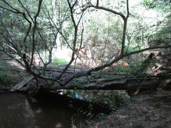
24 No recreational activities were directly observed at any of the 44 sites by SFASU and CES staff. Potential indicators of recreation were present at multiple sites. Naconiche at Cedar Bluff Road (CR 273) Naconiche 8 Attoyac at Highway 59 Naconiche at Highway 59 (Attoyac 7) (Naconiche 6) 24
25 Attoyac Bayou Attoyac 4 (FM 1971), Survey 2: A crocheted blanket spread out on the stream bank next to the bridge crossing with an animal carcass lying on top of it. Attoyac 7 (US 59), Survey 1 & 2: Evidence of fishing as well as general loitering was observed in the form of bait containers, discarded fishing line, beer bottles/cans, soda cans, and plastic bags full of refuse. Observed on the bank during Survey 2 was the carcass of an alligator gar on a fish stringer. 25

26 26
")

27 Attoyac 7 (US 59) 27
28 Attoyac 12 (FM 138), Survey 2: Human foot prints observed along the stream bank underneath the bridge crossing. Also present under the bridge crossing was graffiti. Attoyac 15 (Hwy 7), Survey 2: Human foot prints were observed along the bank underneath the bridge crossing. Attoyac 17 (CR 392), Survey 1: A trot line attached to a tree and stretched across the stream channel was present. 28
")
29 Attoyac 12 (FM 138) 29


30 Attoyac 15 (Hwy 7) 30
")
31 Attoyac 17 (CR 392) 31
32 Big Iron Ore Big Iron Ore 3 (FM 711), Survey 2: Boot prints were observed along the stream bank. 32
")
33 Big Iron Ore 3 (FM 711) 33
34 Naconiche Creek Naconiche 6 (US 59), Survey 1 & 2: ATV tracks present during both surveys underneath Farm to Market (FM) 2435 road crossing. Naconiche 8 (Cedar Bluff Rd.), Survey 1 & 2: Bait net was present in the stream channel, and further downstream a defunct trotline/set hook was attached to a tree and hanging in the stream. A live bait container (worms) was present on the bank next to the public bridge crossing during Survey 2. 34
35 Naconiche 6 (US 59), 35

 36")
36 Naconiche 8 (Cedar Bluff Rd.) 36
37 Terrapin Creek Terrapin 3 (Hwy 7), Survey 1: Animal trap present on left bank, and further downstream a defunct wooden bridge was found across the stream. Terrapin 4 (FM 95), Survey 2: Along the right stream bank, field staff observed a beech tree in which initials had been carved into the bark. 37
")
38 Terrapin 3 (Hwy 7) 38
 39")
39 Terrapin 4 (FM 95) 39
40 West Creek West 6 (FM 2913), Survey 1: Hammock observed attached to a tree located along the stream bank. 40
")
41 West 6 (FM 2913) 41
")
")
")
")
42 Attoyac 2 (CR 3122) Attoyac 8 (CR 294) Attoyac 9 (Private) Naconiche 6 (Hwy 59) 42
")
")


43 Attoyac 6 (CR 4760) Attoyac 2 (CR 3122) Naconiche 9 (CR 280) West 1 (CR 4054) 43
")
")
")
")
44 West 3 (FM 138) Naconiche 11 (FM 95) Naconiche 10 (Private) Attoyac 6 (CR 4760) 44
")

")
")
45 Attoyac 3 (CR 3181) Big Iron Ore 4 (Logging Road) Waffelow 3 (FM 95) Attoyac 4 (FM 1971) 45


46 Rural nature and private land ownership Woody debris, logjams, overgrown banks Low flow in many areas Wildlife 46
47 No recreation (primary or secondary) was directly observed during field work Evidence of recreation was observed at ten (10) of the forty-three (43) survey sites All indicative of secondary or non contact recreation in the form of fishing or bank-based activities. Game camera documentation of secondary recreation at six(6) sites Interviews with landowners and community members indicate sporadic incidences of primary contact recreation Fishing and hunting most common 47
48 Questions? Sarah Fuller, Graduate Research Assistant, Arthur Temple College of Forestry and Agriculture 48
Central and Southeast Texas Recreational Use Attainability Analyses Project Navasota River Below Lake Limestone (Segment 1209) Comprehensive RUAA
 Comprehensive RUAA") Central and Southeast Texas Recreational Use Attainability Analyses Project Navasota River Below Lake Limestone (Segment 1209) Comprehensive RUAA Results Report Contract No. 582-9-90440 EIH Technical Report
Central and Southeast Texas Recreational Use Attainability Analyses Project Navasota River Below Lake Limestone (Segment 1209) Comprehensive RUAA Results Report Contract No. 582-9-90440 EIH Technical Report
BULLHEAD CREEK RANCH
 BULLHEAD CREEK RANCH Located in the southern Texas Hill Country, this ranch offers seclusion for agriculture as well as recreational activities, including hunting, fishing, swimming and hiking. It has
Go Fish Education Center
 Go Fish Education Center December 8, 2011 Jeremy Wixson Go Fish Education Center 1 of every 7 Georgians fish 1 $1.9 billion impact and $1.1 billion in retail sales 2 $116 million generated in state sales
THE RESOURCES AGENCY OF CALIFORNIA Department of Fish and Game STREAM SURVEY
 File form No.. Date: 4/1/73. NAME: Maacama Creek COUNTY: Sonoma. STREAM SECTION: FROM: Maacama Creek Ranch TO: Chalk Hill Rd. Bridge LENGTH: 1.5 mi.. Bridge OTHER NAMES: Weather - Clear & Sunny RIVER SYSTEM:
Downstream Migrant Trapping in Russian River Mainstem, Tributaries, and Estuary
 Downstream Migrant Trapping in Russian River Mainstem, Tributaries, and Estuary Introduction In September 2008, the National Marine Fisheries Service issued the Russian River Biological Opinion, which
Proposed Reclassification of Muskrat Creek, North Platte River Basin in Goshen County, Wyoming
 Proposed Reclassification of Muskrat Creek, North Platte River Basin in Goshen County, Wyoming October 25, 2010 Waterbody: Muskrat Creek - Mainstem of Muskrat Creek from its headwaters downstream to its
Creek Trash Assessment (CTA) Methodology (Demonstration: Mill Run Creek, Cheltenham, Pa.)
 Methodology (Demonstration: Mill Run Creek, Cheltenham, Pa.)") Creek Trash Assessment (CTA) Methodology (Demonstration: Mill Run Creek, Cheltenham, Pa.) Mill Run Creek emerges from a storm sewer in Philadelphia to an open creek in Cheltenham. The Creek downstream
Creek Trash Assessment (CTA) Methodology (Demonstration: Mill Run Creek, Cheltenham, Pa.) Mill Run Creek emerges from a storm sewer in Philadelphia to an open creek in Cheltenham. The Creek downstream
MINISTRY OF ENVIRONMENT ENVIRONMENTAL STEWARDSHIP DIVISION FISH AND WILDLIFE BRANCH. Horsefly River Angling Management Plan
 MINISTRY OF ENVIRONMENT ENVIRONMENTAL STEWARDSHIP DIVISION FISH AND WILDLIFE BRANCH Horsefly River Angling Management Plan January 30 th, 2006 Area/Fishery Description The Horsefly River watershed provides
2017 Annual Report: Survey pf American Alligators (Alligator mississippiensis) in the Big Thicket National Preserve. Summary.
 in the Big Thicket National Preserve. Summary.") 2017 Annual Report: Survey pf American Alligators (Alligator mississippiensis) in the Big Thicket National Preserve Matthew I. Pyne Assistant Professor, Department of Biology, Lamar University, P.O. Box
2017 Annual Report: Survey pf American Alligators (Alligator mississippiensis) in the Big Thicket National Preserve Matthew I. Pyne Assistant Professor, Department of Biology, Lamar University, P.O. Box
2017 RULE CHANGE PROPOSALS
 OKLAHOMA DEPARTMENT OF WILDLIFE CONSERVATION 2017 RULE CHANGE PROPOSALS 1. 800:10-1-3. Additional definitions Add definition for OLAP - walk-in fishing areas and stream access means bodies of water designated
Lake Seminole. and Waters Bordering Georgia and Alabama
 Lake Seminole and Waters Bordering Georgia and Alabama LAKE SEMINOLE Site Description Lake Seminole is a 37,500-acre reservoir located at the juncture of the Florida, Georgia, and Alabama state lines.
Proposed Reclassification of Cherry Creek, North Platte River Basin, Wyoming. October 25, 2010
 Proposed Reclassification of Cherry Creek, North Platte River Basin, Wyoming October 25, 2010 Waterbody: Location: Tributary to: Cherry Creek - Mainstem from headwaters downstream to the confluence with
What was the historic coaster fishery like?
 1 of 6 1/30/2012 12:25 PM Home About Topics Contact Us Fishing Calendar Fish ID Tips FAQs Hack Noyes Research Vessel Is it a unique strain long lost from Wisconsin's shoreline? Fisheries Reports Tributaries
STREAM SURVEY File form No..
 scanned for KRIS THE RESOURCES AGENCY OF CALIFORNIA California Department of Fish and Game STREAM SURVEY File form No.. Date: September 4, 1969. NAME: North Fork Schooner Gulch Creek COUNTY: Mendocino.
Lynx Protection Zone and Trap Restrictions
 Lynx Protection Zone and Trap Restrictions Canada lynx are a federally listed Threatened Species. There is no open season for the trapping or hunting of lynx in Maine. Department biologists have confirmed
Downstream Migrant Trapping in Russian River Mainstem, Tributaries, and Estuary
 Downstream Migrant Trapping in Russian River Mainstem, Tributaries, and Estuary Introduction In September 2008, the National Marine Fisheries Service issued the Russian River Biological Opinion, which
4-H Reel Into Sport Fishing
 4-H Reel Into Sport Fishing S-207 For County Level Competitions A Cooperative Extension Program, University of Arkansas at Pine Bluff, United States Department of Agriculture and County Governments Cooperating
Triple C Ranch 486+/- Acres Upshur County, Texas $1,292,760 ($2660/acre)
") Office: (214) 361-9191 Triple C Ranch 486+/- Acres Upshur County, Texas $1,292,760 ($2660/acre) LOCATION: Triple C Ranch is located in the scenic hills of northwest Upshur County between Winnsboro, TX
Office: (214) 361-9191 Triple C Ranch 486+/- Acres Upshur County, Texas $1,292,760 ($2660/acre) LOCATION: Triple C Ranch is located in the scenic hills of northwest Upshur County between Winnsboro, TX
Pascagoula River Marsh 2017 REEL FACTS Stephen Brown Fisheries Biologist
 Pascagoula River Marsh 217 REEL FACTS Stephen Brown Fisheries Biologist stephenb@mdwfp.state.ms.us General Information: The Pascagoula River marsh is 25 acres of tidal creeks, canals, bays, and streams
Crawford Reservoir. FISH SURVEY AND MANAGEMENT INFORMATION Eric Gardunio, Fish Biologist Montrose Service Center
 FISH SURVEY AND MANAGEMENT INFORMATION General Information: Crawford Reservoir is a popular fishery that provides angling opportunity for yellow perch, channel catfish, northern pike, rainbow trout, black
Pascagoula River Marsh 2018 REEL FACTS Stephen Brown Fisheries Biologist
 Pascagoula River Marsh 218 REEL FACTS Stephen Brown Fisheries Biologist stephenb@mdwfp.state.ms.us General Information: The Pascagoula River marsh is 25 acres of tidal creeks, canals, bays, and streams
MINNESOTA DEPARTMENT OF NATURAL RESOURCES DIVISION OF FISHERIES AND WILDLIFE. Gamefish Assessment Report
 Minnesota DNR F-29-R(P) Area F312 February 1, 2013 MINNESOTA DEPARTMENT OF NATURAL RESOURCES DIVISION OF FISHERIES AND WILDLIFE Gamefish Assessment Report Spring Gamefish Assessment on the Mississippi
Columbia Lake Dam Removal Project
 Columbia Lake Dam Removal Project The Columbia Lake dam located 1/4 mile upstream of the Paulins Kill River's confluence with the Delaware River in Knowlton Township, Warren County has been proposed for
Broaddus Loop. Lufkin & Angelina County Bicycle Route. Total Miles:
 Lufkin & Angelina County Bicycle Route Total Miles: 72.6 www.visitlufkin.com Route Directions: Segment Distance Direction of Total Distance Road Traveled (miles) Turn (miles) Start Lufkin High School
OREGON AND WASHINGTON DEPARTMENTS OF FISH AND WILDLIFE JOINT STAFF REPORT SUMMER FACT SHEET NO.
 OREGON AND WASHINGTON DEPARTMENTS OF FISH AND WILDLIFE JOINT STAFF REPORT SUMMER FACT SHEET NO. 1 Columbia River Compact/Joint State Hearing June 28, 2018 Fisheries under consideration: Treaty commercial
Yellow Kayak. Free Yellow Kayak Pdf - Bifincankahve.com download yellow kayak free pdf, download yellow kayak pdf, read online yellow kayak pdf,
 We have made it easy for you to find a PDF Ebooks without any digging. And by having access to our ebooks online or by storing it on your computer, you have convenient answers with yellow kayak. To get
Minnesota Department of Natural Resources Division of Fish and Wildlife Section of Fisheries. Stream Survey Report. Luxemburg Creek.
 Minnesota F-29-R(P)-24 Area 315 Study 3 March 2016 Minnesota Department of Natural Resources Division of Fish and Wildlife Section of Fisheries Stream Survey Report Luxemburg Creek 2015 Mark Pelham Sauk
Dallas District Men s Retreat Fishing Tournament Rules and Regulations
 Dallas District Men s Retreat Fishing Tournament Rules and Regulations Date: Friday and Saturday, September 19 & 20 Location: Caddo Lake See map for public boat launch locations Entry Fee: $25 per person/$40
Big Spring Creek Habitat Enhancement and Fishery Management Plans
 Big Spring Creek Habitat Enhancement and Fishery Management Plans November 5, 2012 Big Spring Events and Activities Center Newville, PA Charlie McGarrell Regional Habitat Biologist Pennsylvania Fish and
Chapter 11 Highway and Rural Driving
 Chapter 11 Highway and Rural Driving 11-1 THE RURAL DRIVING ENVIRONMENT A. Complete each of the following sentences by writing the correct word or phrase in the space provided. 1. The most heavily traveled
Penns Creek, Section 05 Fishery Update and Regulation Review
 Penns Creek, Section 05 Fishery Update and Regulation Review Mission: To protect, conserve, and enhance the Commonwealth s aquatic resources and provide fishing and boating opportunities 66-mile long tributary
Natural Resource Enterprises: Enhancing Conservation and Income on Private Lands in Mississippi
 Natural Resource Enterprises: Enhancing Conservation and Income on Private Lands in Mississippi Connecting Entrepreneurial Communities Wednesday 8, 2014 Recreational Access Recreation on Private Lands
Pearl River 2018 Middle Reach REEL FACTS Dustin Rodgers Fisheries Biologist
 Pearl River 1 Middle Reach REEL FACTS Dustin Rodgers Fisheries Biologist dustinr@mdwfp.state.ms.us General Information: The Pearl River contains the third largest drainage basin in Mississippi. A variety
Columbia Lake Dam Removal Project
 Columbia Lake Dam Removal Project Major Goals of the Columbia Lake Dam Removal: Reconnect 10 miles of the Paulins Kill River to the Delaware River, restoring natural flow regime and sediment transport.
Rappahannock River from Chester Gap to Chesapeake Bay
 Rappahannock River from Chester Gap to Chesapeake Bay Location: The Rappahannock River runs 186 miles from the Chester Gap (N38.92401 W78.09573) to Chesapeake Bay (N73.62028 W76.41750) Fredericksburg (N38.29860
Crawford County Agriculture News June 22, 2018
 Crawford County Agriculture News June 22, 2018 A NOTE FROM YOUR AGENT Got a Catalpa Tree? I am on the hunt for a catalpa tree with an active worm population. If you wouldn t mind me coming to collect some
Twin Canyons Ranch 3,019+/- Acres Throckmorton County, Texas $4,211,505 ($1,395/acre)
") Office: (214) 361-9191 Twin Canyons Ranch 3,019+/- Acres Throckmorton County, Texas $4,211,505 ($1,395/acre) GENERAL DESCRIPTION: The 3019+/- acre Twin Canyons Ranch is one of the most scenic and majestic
Office: (214) 361-9191 Twin Canyons Ranch 3,019+/- Acres Throckmorton County, Texas $4,211,505 ($1,395/acre) GENERAL DESCRIPTION: The 3019+/- acre Twin Canyons Ranch is one of the most scenic and majestic
Claytor Lake View of the Claytor Lake dam from Claytor Lake State Park s boat ramp.
 Claytor Lake 2007 Imagine yourself on a waterbody that is more like a wide river than a lake. When you do, you will have a picture of Claytor Lake. Claytor Lake, a 4,475-acre reservoir, stretches northeastward
Mill Creek/Rose Valley Watershed General Information Presented by Dr. Mel Zimmerman Lycoming College CWI
 Mill Creek/Rose Valley Watershed General Information Watershed Concerns Rose Valley Lake Areas of Interest Biodiversity of Interest in Rose Valley Lake Rose Valley Lake Bird Area Fishes of Rose Valley
NEVADA DEPARTMENT OF WILDLIFE STATEWIDE SPORT FISHERIES MANAGEMENT
 NEVADA DEPARTMENT OF WILDLIFE STATEWIDE SPORT FISHERIES MANAGEMENT FEDERAL AID JOB PROGRESS REPORT F-20-50 2014 Urban Sport Fisheries SOUTHERN REGION NEVADA DEPARTMENT OF WILDLIFE, FISHERIES DIVISION ANNUAL
COLUMBIA LAKE DAM REMOVAL PROJECT
 COLUMBIA LAKE DAM REMOVAL PROJECT Major Goals of the Columbia Lake Dam Removal: Reconnect 10 miles of the Paulins Kill River to the Delaware River, restoring natural flow regime and sediment transport.
Appendix H Recreation and Tourism (Chapter 8) Contents. List of Tables
 Contents. List of Tables") Appendix H Recreation and Tourism (Chapter 8) Contents Trends Data... H-2 CA DMV records... H-2 CA DFG Hunting/Fishing Licenses... H-2 USDA Agricultural Tourism... H-4 United States Forest Service... H-6
Appendix H Recreation and Tourism (Chapter 8) Contents Trends Data... H-2 CA DMV records... H-2 CA DFG Hunting/Fishing Licenses... H-2 USDA Agricultural Tourism... H-4 United States Forest Service... H-6
Minnesota Department of Natural Resources Division of Fish and Wildlife Section of Fisheries. Stream Survey Report. Three Mile Creek 2011
 Minnesota Department of Natural Resources Division of Fish and Wildlife Section of Fisheries Stream Survey Report Three Mile Creek 2011 By Joseph D. Stewig Montrose Area Fisheries Office TABLE OF CONTENTS
Colusa Basin Drain Watershed Fish Stranding Tour Concept Paper Mike Hendrick and Brycen Swart NMFS
 Colusa Basin Drain Watershed Fish Stranding Tour Concept Paper Mike Hendrick and Brycen Swart NMFS On May 31, 2013 representatives from CDFW, USFWS, and NMFS went on a field tour to look at locations in
Steelhead Sport Fishing Regulations Proposals Vancouver Island Region for April 1, 2007
 Steelhead Sport Fishing Regulations Proposals Vancouver Island Region for April 1, 2007 Sport fishing regulations governing steelhead fishing have changed many times over the past 30 years. Generally the
Note: You do not need to be a Wisconsin landowner; we ll consider any woodland owner in the Midwest region.
 COVERTS COOPERATOR APPLICATION for the 2018 Wisconsin Coverts Project Workshop at Kemp Natural Resources Station in Woodruff, WI August 16-19, 2018 We re looking for private landowners who are interested
Eureka Ranch 1,087+/- Acres Coleman County, Texas $2,168,565 ($1,995/acre)
") Office: (214) 361-9191 Eureka Ranch 1,087+/- Acres Coleman County, Texas $2,168,565 ($1,995/acre) LOCATION: The ranch is located in the eastern part of Coleman County, approximately 12 miles east of Coleman,
Office: (214) 361-9191 Eureka Ranch 1,087+/- Acres Coleman County, Texas $2,168,565 ($1,995/acre) LOCATION: The ranch is located in the eastern part of Coleman County, approximately 12 miles east of Coleman,
A Sportsman's Guide to Landowner Relations
 MT 9813 Agriculture A Sportsman's Guide to Landowner Relations by Larry Brence, Fallon-Carter County Extension Agent and Jim Knight, Extension Wildlife Specialist Sportsmen have long enjoyed Montana as
Gamefish Assessment Report
 MINNESOTA DEPARTMENT OF NATURAL RESOURCES Gamefish Assessment Report Spring Gamefish Assessment on the Mississippi River from Little Falls to Brainerd, MN May 31 through June 4, 2013 River Miles 966 to
Reading the River! 2002
 Reading the River! 2002 Reading the River! 2002 Primary Funding: Kentucky Council on Postsecondary Education through its Eisenhower Professional Development Program Partner Organizations: Partner Organizations:
South Fork Chehalis Watershed Culvert Assessment
 South Fork Chehalis Watershed Culvert Assessment Water Resource Inventory Area 23 Lewis County Conservation District Final Report By: Kelly Verd and Nikki Wilson March 2003 Funded by: The Washington State
2016 Volunteer Program Annual Report
 The mission of the Oregon Department of Fish & Wildlife Volunteer Program is to actively involve citizens as volunteers in the protection and enhancement of Oregon s fish and wildlife resources for the
A REAL FISH STORY. Fifteen Years of Great Fishing on Two Kansas Lakes Milford Lake and Tuttle Creek Lake. 45,024 Fish Caught
 A REAL FISH STORY Fifteen Years of Great Fishing on Two Kansas Lakes Milford Lake and Lake 45,024 Fish January 1st, 2003 through January 1st, 2018 Submitted by Ron Harrison Total Catfish 2003 to 2018 Year
Columbia River Fishery Notice
 Columbia River Fishery Notice Oregon Department of Fish and Wildlife January 29, 2014 Compact Action The Columbia River Compact agencies of Oregon and Washington met today and took the following actions:
(Revised February,2005) CULVERTS, BRIDGES, AND FORDS
 CULVERTS, BRIDGES, AND FORDS") GUIDE TO STREAM CROSSINGS (Revised February,2005) CULVERTS, BRIDGES, AND FORDS Culverts, bridges, and fords are all methods used to cross-streams. Culverts are the most common stream crossing structure.
GUIDE TO STREAM CROSSINGS (Revised February,2005) CULVERTS, BRIDGES, AND FORDS Culverts, bridges, and fords are all methods used to cross-streams. Culverts are the most common stream crossing structure.
Kasaan to Goose Creek Road Project Project Description U.S. Army Corps of Engineers Permit The following table presents the mile point of the culverte
 Kasaan to Goose Creek Road Project Project Description U.S. Army Corps of Engineers Permit The following table presents the mile point of the culverted open water crossings, name of water crossing if known,
Full Spectrum Deer Management Services
 Full Spectrum Deer Management Services Wildlife Specialists, LLC, offers full spectrum custom deer management services designed to meet the specific project goals of our clients from individual landowners
Deer and Deer Management in Central New York: Local Residents Interests and Concerns
 Deer and Deer Management in Central New York: Local Residents Interests and Concerns NYS Department of Environmental Conservation Division of Fish, Wildlife & Marine Resources and the Human Dimensions
1.Mill Creek Watershed Summary Description and Land Use
 1.Mill Creek Watershed Summary Description and Land Use Table xxx: Mill Creek Watershed Overview Watershed Size 31,435 acres/49.1 sq miles/ 127.1 sq km Elevation Range 5,594 feet [4,967-10,561] Stream
STREAM Girls field notebook
 s STREAM Girls field notebook Welcome...... to your stream! Trout Unlimited is excited to offer you and other Girl Scouts the chance to really get to know your home waters. Over the next three days, you
Stream Assessment Cut-block: For: Island Timberlands Limited Partnership, Cameron Operation
 Stream Assessment Cut-block: 171214 For: Island Timberlands Limited Partnership, Cameron Operation Tony Norris Area Engineer Island Timberlands Cameron Operation Port Alberni D.G. Rigets E.I.A. CTech.
POLITICS A MONUMENTAL TASK FOR STREAM RESTORATION: AN EXAMPLE FROM TRAPPER CREEK OREGON
 POLITICS A MONUMENTAL TASK FOR STREAM RESTORATION: AN EXAMPLE FROM TRAPPER CREEK OREGON Bradley S. Houslet and Louis Wasniewski Deschutes National Forest TRAPPER CREEK, OR ODELL LAKE PROJECT OBJECTIVES
Cloverdale Ranch 1, /- Acres Fannin County, Texas $3,997,116 ($2,695/acre) Office: (214)
 Office: (214)") 1,483.16+/- Acres Fannin County, Texas $3,997,116 ($2,695/acre) Office: (214) 361-9191 Fannin County, Texas 1483.16 +/- Acres LOCATION: Historic Cloverdale Ranch is located in northwest Fannin County with
1,483.16+/- Acres Fannin County, Texas $3,997,116 ($2,695/acre) Office: (214) 361-9191 Fannin County, Texas 1483.16 +/- Acres LOCATION: Historic Cloverdale Ranch is located in northwest Fannin County with
Maryland Chapter Trout Unlimited Brook Trout Conservation Effort
 Maryland Chapter Trout Unlimited Brook Trout Conservation Effort Photo by Matt Kline Portfolio of Recent Work MDTU Brook Trout Conservation Coordinator: Scott C. Scarfone, ASLA sscarfone@oasisdesigngroup.com
Clallam County Shoreline Master Program Update. Draft Public Land/Access Inventory Emphasis on Shoreline Public Access
 Clallam County Shoreline Master Program Update Draft Public Land/Access Inventory Emphasis on Shoreline Public Access Outline Public Lands Public Shoreline Access Inventory Marine Shoreline Freshwater
For more information or permission to reprint slides, please contact Donna Milligan at 1
 For more information or permission to reprint slides, please contact Donna Milligan at milligan@vims.edu 1 For more information or permission to reprint slides, please contact Donna Milligan at milligan@vims.edu
DMU 065 Ogemaw County Deer Management Unit
 DMU 065 Ogemaw County Deer Management Unit Area Description Ogemaw County Deer Management Unit is in the Northern Lower Peninsula Region (NLP). It has roughly 99,000 acres of public land which is about
The week of October, 6 th Serving People, Managing Wildlife
 The week of October, 6 th 2014 Wildlife Division Serving People, Managing Wildlife! Resident only Pheasant season runs October 11 th October 13 th.! Regular Pheasant season starts October 18 th and runs
COASTAL WETLAND SURVEY. Location: Sec. 35, 36 T. 13N R. 17W Quadrangle: Pt. Arena (7 1/2 min) Field Investigator: Gayle Dana Date of Survey : 2/22/78
 Field Investigator: Gayle Dana Date of Survey : 2/22/78") COASTAL WETLAND SURVEY Name of Area: Garcia River County : Mendocino Location: Sec. 35, 36 T. 13N R. 17W Quadrangle: Pt. Arena (7 1/2 min) Ownership : Private Field Investigator: Gayle Dana Date of Survey
COASTAL WETLAND SURVEY Name of Area: Garcia River County : Mendocino Location: Sec. 35, 36 T. 13N R. 17W Quadrangle: Pt. Arena (7 1/2 min) Ownership : Private Field Investigator: Gayle Dana Date of Survey
Teton County Related Hunting and Fishing Spending, For the Wyoming Wildlife Federation. David T. Taylor & Thomas Foulke
 Teton County Related Hunting and Fishing Spending, 2015 For the Wyoming Wildlife Federation University of Wyoming, Department of Agricultural & Applied Economics David T. Taylor & Thomas Foulke 1 February
Wind Rock Ranch DUBOIS, WYOMING
 Wind Rock Ranch DUBOIS, WYOMING Wind Rock Ranch DUBOIS, WYOMING Introduction: The Wind Rock Ranch is located in Fremont County, Wyoming, six miles south-east of the town of Dubois, WY. The ranch headquarters
Fremont County Related Hunting and Fishing Spending, 2015
 Fremont County Related Hunting and Fishing Spending, 2015 For the Wyoming Wildlife Federation University of Wyoming, Department of Agricultural & Applied Economics David T. Taylor & Thomas Foulke September,
Interim Guidance Fish Presence Absence
 Interim Guidance Fish Presence Absence Source: Forest Practices Act Guidance for Division 635 of the forest practices act dealing with stream classification when no fish surveys have been done (referenced
Lake information report
 Lake information report: Minnesota DNR Page of 5 Lake information report jf Prinlable senior Name: Spring Nearest Town: Spring Lake (Scott) Primary County: Scott Survey Date: 08/02/200 Inventory Number:
SKIATOOK LAKE MANAGEMENT PLAN
 SKIATOOK LAKE MANAGEMENT PLAN Background Skiatook Lake impounds Hominy Creek, 5 miles west of Skiatook in Osage County, Oklahoma (Figure 1). Skiatook Lake covers 10,540 surface acres and was constructed
Fish Community. Fish Habitat, Streams and Rivers
 Clear, Ston(e)y and White Lake Plan Fish Community The lakes support a cool/warm water fishery including muskellunge, walleye, largemouth and smallmouth bass, yellow perch, pumpkinseed, rockbass, blue
Lower Mississippi River Dispatch No. 289 Wednesday, May 20th, 2015 Mark River: The Spawn Mark River: The Spawn
 Lower Mississippi River Dispatch No. 289 Wednesday, May 20th, 2015 Mark River: The Spawn Mark River: The Spawn The month of March brings the snow melt and the warm rains to the Mississippi River Watershed.
Carbon County Related Hunting and Fishing Spending, 2015
 Carbon County Related Hunting and Fishing Spending, 2015 1 For the Wyoming Wildlife Federation University of Wyoming, Department of Agricultural & Applied Economics AAAAddd David T. Taylor & Thomas Foulke
DMU 452 Northern Multi-County Deer Management Unit
 DMU 452 Northern Multi-County Deer Management Unit Area Description The Core TB Zone Deer Management Unit is in the Northern Lower Peninsula Region (NLP) and covers portions of Alcona, Alpena, Montmorency,
Manual of Fisheries Survey Methods II: with periodic updates. Chapter 22: Guidelines for Sampling Warmwater Rivers with Rotenone
 Manual of Fisheries Survey Methods II: with periodic updates : Guidelines for Sampling Warmwater Rivers with Rotenone P. W. Seelbach, G. L. Towns, and D. D. Nelson Suggested citation: Seelbach, Paul W.,
Regulations. Grabbling season May 1 July 15; only wooden structures allowed.
 Arkabutla Reservoir 219 REEL FACTS Keith Meals, Arthur Dunn, Stanley Turner Fisheries Biologists keithm@wfp.ms.gov, ArthurD@wfp.ms.gov, StanleyT@wfp.ms.gov General Information: Arkabutla Reservoir is one
Southeast Regional Office:
 Southeast Regional Office: The Bridge from Science to Management Southeast Region Marine Resource Education Program Tampa, Florida Sept 30-Oct 2, 2014 Southeast Region Roles and Responsibilities Forecasting
OREGON DEPARTMENT OF FISH AND WILDLIFE ROGUE FISH DISTRICT REPORT
 OREGON DEPARTMENT OF FISH AND WILDLIFE ROGUE FISH DISTRICT REPORT TITLE: Upper Rogue Smolt Trapping Project, 1999 STREAM: Big Butte, Little Butte, South Fork Big Butte, Slate and West Fork Evans Creeks
SOCIETAL GOALS TO DETERMINE ECOSYSTEM HEALTH: A FISHERIES CASE STUDY IN GALVESTON BAY SYSTEM, TEXAS
 SOCIETAL GOALS TO DETERMINE ECOSYSTEM HEALTH: A FISHERIES CASE STUDY IN GALVESTON BAY SYSTEM, TEXAS Anthony S. Pait, NOAA, National Centers for Coastal Ocean Science Thomas P. O Connor, David R. Whitall,
Project Name: Distribution and Abundance of the Migratory Bull Trout Population in the Castle River Drainage (Year 4 of 4)
") Alberta Conservation Association (ACA) Date: 2014-2015 Project Name: Distribution and Abundance of the Migratory Bull Trout Population in the Castle River Drainage (Year 4 of 4) Fisheries Program Manager:
Alberta Conservation Association (ACA) Date: 2014-2015 Project Name: Distribution and Abundance of the Migratory Bull Trout Population in the Castle River Drainage (Year 4 of 4) Fisheries Program Manager:
Tunica Cutoff 2018 REEL FACTS Keith Meals Fisheries Biologist
 Tunica Cutoff 218 REEL FACTS Keith Meals Fisheries Biologist keithm@mdwfp.state.ms.us General Information: Tunica Cutoff was created by the US Army Corps of Engineers (COE) in 1942 when a bend in the Mississippi
NEVADA DEPARTMENT OF WILDLIFE STATEWIDE FISHERIES MANAGEMENT
 NEVADA DEPARTMENT OF WILDLIFE STATEWIDE FISHERIES MANAGEMENT FEDERAL AID JOB PROGRESS REPORTS F-20-49 2013 SQUAW CREEK RESERVOIR WESTERN REGION Contents NEVADA DEPARTMENT OF WILDLIFE, FISHERIES DIVISION
Stevens Point Furbearer Ecology Workshop Mar 10 12, 2017
 Stevens Point Furbearer Ecology Workshop Mar 10 12, 2017 REGISTRATION FORM Robert Savannah, U. S. Fish and Wildlife Service General information: On Mar 10-12, the Wisconsin Trappers Association and the
Proposed Reclassification of Deer Creek, North Platte River Basin, Wyoming
 Proposed Reclassification of Deer Creek, North Platte River Basin, Wyoming October 25, 2010 Waterbody: Location: Tributary to: Deer Creek - Mainstem from headwaters downstream to the confluence with the
Basic Information Everyone Should Know
 Basic Information Everyone Should Know The Maine Department of Inland Fisheries & Wildlife 2009 PROPOSED IFW BUDGET REDUCTIONS Without Fee Increase With Fee Increase Fiscal Year 2010 $2,405,612 $1,683,112
Area Fish Stocking. Area Happenings
 Seth Lundgren District Fisheries Biologist Kansas Department of Wildlife, Parks and Tourism 5089 CR 2925 Independence, KS 67301 (620) 331-6820 seth.lundgren@ks.gov Area Happenings It has been a busy fall
Frequently Asked Questions About Revised Critical Habitat and Economic Analysis for the Endangered Arroyo Toad
 Q Frequently Asked Questions About Revised Critical Habitat and Economic Analysis for the Endangered Arroyo Toad Q. What is the arroyo toad? The arroyo toad (Bufo californicus) is a small, light greenish-grey
021 Deer Management Unit
 021 Deer Management Unit Geographic Location: Deer Management Unit (DMU) 021 is 1,464 square miles in size and is located in the central Upper Peninsula (UP). This DMU is dominated by publicly owned land
San Patricio County Guided Fishing Market Research
 Guided Fishing Market Research San Patricio County, TX Miles Philips, Extension Specialist Texas A&M Agrilife Extension College Station, TX T: 979-845-1023 E: mdphillips@ag.tamu.edu http://fishing.tamu.edu
Lake Powell Fish Report June 20, 2018 Lake Elevation: 3611 Water temperature: F
 Lake Powell Fish Report June 20, 2018 Lake Elevation: 3611 Water temperature: 73-76 F By: Wayne Gustaveson http://www.wayneswords.com or Wayneswords.net My weekly fishing trip began in perfect fashion.
NEVADA DEPARTMENT OF WILDLIFE STATEWIDE FISHERIES MANAGEMENT FEDERAL AID JOB PROGRESS REPORTS F EUREKA COUNTY Small Lakes and Reservoirs
 NEVADA DEPARTMENT OF WILDLIFE STATEWIDE FISHERIES MANAGEMENT FEDERAL AID JOB PROGRESS REPORTS F-20-48 2012 EUREKA COUNTY Small Lakes and Reservoirs NEVADA DEPARTMENT OF WILDLIFE, FISHERIES DIVISION ANNUAL
Warden Tom Kasnick August 30, 1983
 scanned for KRIS Franz Creek Warden Tom Kasnick August 30, 1983 - Region 3 Franz Creek, Sonoma County - Fish Kill and Pollution Incident On August 3, 1983, you requested that I investigate a reported fish
ARKANSAS RIVER, LAKE FORK
 ARKANSAS RIVER, LAKE FORK 2012 The station just below County Road 11 (LF1) is routinely sampled as part of the protocol to monitor fish population changes relative to heavy metal cleanup in the Leadville
Orange County MARINE PROTECTED AREAS
 Orange County MARINE PROTECTED AREAS Orange County Coastkeeper QUARTERLY REPORT 1/1/ 2013 3/30/12 2013 WHAT IS THE OC MPA WATCH PROGRAM? The Orange County Marine Protected Area (OC MPA) Watch Program enlists
Orange County MARINE PROTECTED AREAS
 Orange County MARINE PROTECTED AREAS Orange County Coastkeeper QUARTERLY REPORT 7/1/2013 9/30/2013 WHAT IS THE OC MPA WATCH PROGRAM? The Orange County Marine Protected Area (OC MPA) Watch Program enlists