Creek Trash Assessment (CTA) Methodology (Demonstration: Mill Run Creek, Cheltenham, Pa.)
|
|
|
- Eustace Nelson
- 5 years ago
- Views:
Transcription

1 Creek Trash Assessment (CTA) Methodology (Demonstration: Mill Run Creek, Cheltenham, Pa.) Mill Run Creek emerges from a storm sewer in Philadelphia to an open creek in Cheltenham. The Creek downstream of Cheltenham Ave. has extensive trash build-up along the banks and in the creek bed. PWD s T MS4 outfall is one of 12 outfalls along Mill Run Creek between Cheltenham Ave and New 2nd Street. This paper documents the application of the Creek Trash Assessment Methodology to approximately 0.5 miles of Mill Run Creek to demonstrate how this method could be applied to Philadelphia area creeks. Extensive Creek Trash between Coventry Ave. and Valley Rd., left bank: Cheltenham, Pa. Kelly O Day
2 Creek Trash Assessment The Tookany - Tacony Creek has a serious creek trash problem. It is likely that other Philadelphia area creeks have similar creek trash problems. How do we systematically assess the trash conditions in our urban creeks? While there is systematic monitoring of chemical and biological water quality measures (DO, ph, specific conductance, temperature,etc) of the Tookany - Tacony and other creeks by PWD, Pa DEP, USGS and others, there is no systematic monitoring of creek trash. There are several factors that contribute to the difficulty of monitoring the severity of creek trash conditions and identifying the specific sources for observed creek trash: 1. Multiple Potential Sources of Creek Trash - Trash in Upstream flow - Overland flow of litter/ trash to creek - Outfall Discharge to creek - Illegal Dumping near creek 2. Materials Behave Differently in Water - Paper deteriorates quickly - Plastic bottles float - may travel longer distances - Plastic bags - often snagged by bank branches or entrained in creek bed 3. Creek Channel Conditions Affect Trash Deposition - Smooth - concrete channels do not retain trash - Rocky channels may retain plastic bags, bottles - Branches, bank vegetation may trap plastic bags, other flexible material - Woody debris jams may retain plastic bags, food wrappers, bottles, other debris - Backwater pools may retain bottles, floating material 4. Measurement Limitations - No instrumentation can monitor the wide variety of trash objects under all conditions - Must rely on visual observation (counts, photos, field notes) - AWS has shown discrepancy between visual observations and full trapping counts - Unit of measure (weight [ dry or wet], counts [bottle versus tire?], size ) To effectively assess creek trash conditions and sources of observed creek trash, we need a systematic method that addresses these issues so that creek trash assessment can be routinely conducted, problem creek hot spots can be identified, and corrective actions undertaken. The assessment methods need to be reproducible by independent observers. 2
3 Creek Trash Assessment (CTA) Prototype While there are a number of techniques for analyzing various aspects of urban creek trash problems, the author has not found a systematic, reproducible methodology for comprehensively investigating the sources and severity of small creek trash problems. This paper applies a 3 step Creek Trash Assessment process to 4 creek segments in a Philadelphia area creek to demonstrate how this field survey - analysis approach could be applied to Philadelphia area creeks to determine the severity, extent and potential sources of creek trash. CTA - A 3 Step Process 1. Preparation - Prepare GIS map of creek stretch to be evaluated - Locate outfalls on map - (Optional) Initial Walk to establish background on site conditions, if necessary - Establish creek segments based on outfalls, flow patterns, channel conditions, trash inputs 2. Field Trash Survey - Walk in creek channel to observe, photograph bed and bank trash conditions - Assess potential upstream trash discharge to stretch of creek to be studied - Assess outfall discharges, upstream/ downstream conditions - Record channel roughness - Assign channel segment Level of Trash Qualitative Rating - Record significant trash build-up areas o Location - use GPS unit & digital camera o Method of deposition * Snag in woody debris jam * Channel beaching * High water beaching o Type of trash material * Neutral buoyancy (plastic bags) * Floaters (bottles, plastic or Styrofoam cups) o Extent of Build-up 3. Analysis - Think mass balance - Map sources, channel roughness, build-ups, segments trash scores - Link sources to segment conditions (may be obvious, often difficult) This method uses the ESRI ArcGIS Explorer geographic information system (GIS) to provide basic mapping capability as well as Philadelphia Water Department (PWD) data resources for GIS data files of watershed boundaries, detailed creek polygons, watershed sub-drainage areas and outfalls in the TTF Watershed. 3
4 How Do We Assess Level of Creek Trash? Everyone knows creek trash when he/she sees it, a plastic bag caught in a branch, a plastic bottle on the creek bank or a food wrapper caught by creek bed rocks. We need a systematic method to categorize the severity of creek trash so that we can identify creek trash hot spots and be able to rank trash conditions among locations and at a given location over time. Maryland and California have been leading states in creek trash analysis. The Anacostia River in Maryland and San Francisco Bay in California have been particularly well studied. The Washington DC Metropolitan Council of Governments developed the Anacostia Stream Trash Surveying Methodology and Indexing System in 1998 to characterize trash levels in stretches of the Anacostia River. All trash items in a given segment are counted, an average items per 100 ft segment is calculated and a Verbal Ranking is assigned to the stream segment based on the average counts of trash per 100 foot length of stream. This table shows the Anacostia verbal rankings. Anacostia Stream Trash Indexing System No. Items per 100 ft Verbal Ranking None - Very Light Light Moderate >50 High The California Surface Water Ambient Monitoring Program (SWAMP) has developed a comprehensive Rapid Trash Assessment (RTA) Method to monitor trash in California streams. Like the Anacostia method, the scoring system is based on 100 foot segments of creek. The RTA method is applied to pre-defined 100 foot stream segments, it is not intended to be a creek wide assessment method. Creek trash counting would appear to be a good method for assessing creek trash conditions, however, the practical aspects of counting each piece of litter in 100 foot creek segments make this approach unworkable for a watershed like the Tookany - Tacony. With over 32 miles of creek in the TTF Watershed, subdividing the creek into 100 foot segments would require nearly 1,700 segments. Counting each individual piece of creek trash in the 32 miles of creek is simply not practical. There are 2 distinct levels of creek trash survey: 1) creek wide surveys and 2) site specific surveys. The RTA looks like an excellent tool for site specific surveys, particularly if the sites are surveyed over time to assess changes. Creek wide surveys need to address a larger area than a RTA survey, often covering miles in one survey. The proposed Creek Trash Assessment uses a simplification/ modification of the Anacostia and California RTA methods by conducting a visual - photographic survey on an extended creek stretch,usually miles, and applying a verbal trash ranking using the California SWAMP s Level of Trash verbal rankings. Here is what the RTA guidance manual says about their Level of Trash parameter. Level of Trash. This assessment parameter is intended to reflect a qualitative first impression of the site, after observing the entire length of the reach. Sites scoring in the poor range are those where trash is one of the first things noticeable about the waterbody. No trash should be obviously visible at sites that score in the optimal range. Source: California SWAMP RTA Guidance manuals 4
5 The Creek Trash Assessment uses the RTA Level of Trash verbal rank. The numeric criteria are used for guidance, no actual field trash counts are used to assign the Level of Trash Ranking. Level of Trash Verbal Ranking Based on Rapid Trash Assessment Methodology for Parameter 1. No. Items per 100 ft Verbal Rank < 10 Optimal Sub Optimal Marginal > 100 Poor Description: From RTA Manual On first glance, no trash visible; little or no trash evident when streambed and streambanks are closely examined for litter and debris, for instance by looking under leaves. On first glance, little or no trash visible; after close inspection small levels of trash evident in streambank and streambed. Trash is evident in low to medium levels on first glance. Streambank surfaces and immediate riparian zone contain litter and debris. Evidence of site being used by people: scattered cans, bottles, blankets, and/or clothing. Trash distracts the eye on first glance. Streambank surfaces and immediate riparian zone contain substantial levels of litter and debris. Evidence of site being used frequently by people: many cans & bottles, food wrappers, manmade shelters, blankets, and/or piles of clothing. The Mill Run Creek offers an excellent location to develop and test creek trash assessment techniques because it only has one major trash source, stormwater outfalls. Since PWD s T outfall makes up the entire upstream flow for the Creek, we do not need to worry about other potential upstream sources. Inspection of the area around the Creek shows that there is minimal potential overland flow of litter/ trash and illegal dumping. The next sections apply the Creek Trash Assessment to the Mill Run from its Philadelphia storm sewer outfall at Cheltenham Ave to a point approximately 2,800 feet downstream. 5


6 Mill Run Creek Trash Assessment: Step 1- Preparation The ArcGIS Explorer GIS desktop application (free) and PWD outfall data layer were used for this analysis. Figure 1 shows a portion of the GIS map with the 12 Mill Run Creek outfalls. Figure 1: ArcGisExplorer GIS map with Outfalls Figure 2: PWD Outfall T Just Below Cheltenham Ave Figure 2 shows PWD s T outfall which comprises the entire Mill Run Creek flow just downstream of Cheltenham Ave. 6

7 Figure 3 shows the Mill Run segments based on outfall locations, channel roughness conditions as well as initially observed trash conditions. Figure 3: Mill Run Creek Trash Survey Segments 7
8 Mill Run Creek Trash Assessment: Step 2 - Field Trash Survey Trash photo surveys were conducted on 4 dates: Date Number of Photos 2/25/ /12/ /15/ /22/ Photos were taken with a GPS enabled digital camera that recorded date and time of each photo. All photos were transfered from the camera to a desktop computer and stored in Adobe s Lightroom s image management system. Since the photos are time stamped, it is possible to reconstruct the sequence of photography for each survey. The Mill Run trash survey covered approximately 2,800 feet downstream of PWD s T MS4 outfall. Segment A extends approximately 160 feet from PWD s outfall to the Coventry Ave Bridge, shown in Figure 4. Figure 4: Mill Run - Segment A - From PWD Outfall in Background to Coventry Ave Bridge in Foreground This segment has a channel roughness rating of rough, because of the rocky channel bottom and limited bank branches to trap trash. The calculated Level of Trash guidance values for Segment A are shown in this table. Level of Trash Optimal < 10/ 100 ft Sub Optimal 10-50/ 100 ft Marginal / 100 ft Poor > 100 / 100 ft Segment A (160 ft) No. pieces < > 160 Figure 5 shows the Segment A trash conditions, as photographed in February - March, The Level of Trash rating for Segment A is Marginal. 8


9 Figure 5: Mill Run Creek - Segment A Trash Accumulation a. Segment A Overview - Some litter visible c. Segment A: Trash e. Segment A: Trash, right bank b. Segment A: Trash, right bank just below outfall d. Segment A: Trash, right bank f. Segment A: Trash, right bank, just upstream Coventry Ave 9
10 Segment B extends approximately 640 feet from the Coventry Ave Bridge to Valley Road. This segment has a channel roughness rating of very rough, because of the rocky channel bottom and extensive bank branches and vegetation that trap trash. The calculated Level of Trash guidance values for Segment B are shown in this table. Level of Trash Optimal < 10/ 100 ft Sub Optimal 10-50/ 100 ft Marginal / 100 ft Poor > 100 / 100 ft Segment B (640 ft) No. pieces < > 640 Figure 6 shows trash conditions in Segment B, as photographed in February - March, The Level of Trash rating for Segment B is Poor. 10


11 Figure 6: Mill Run Creek - Segment B Trash Accumulation a. Segment B: Right bank just below Coventry Ave c. Segment B: Right Bank e. Segment B: Right bank, midway in segment b. Segment B: Right bank below Coventry Ave d. Segment B: Right bank f. Segment B: Channel, just upstream Valley Road 11
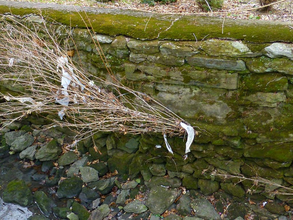
12 Segment C extends approximately 460 feet from Valley Road to just east of Asbury Road. This segment has a channel roughness rating of smooth, because of the constructed stone walls and paved channel bottom with only minor vegetation in a few isolated areas. The calculated Level of Trash guidance values for Segment C are shown in this table. Level of Trash Optimal < 10/ 100 ft Sub Optimal 10-50/ 100 ft Marginal / 100 ft Poor > 100 / 100 ft Segment C (460 ft) No. pieces < > 634 Since Mill Run in Segment C is completely channelized, with vertical stone walls and a sloped smooth bottom, there is very little trash build-up in this segment. Segment C clearly demonstrates the importance of channel roughness in assessing creek trash. While Segment B and D, upstream and downstream of Segment C, have considerable creek trash, Segment C has very little. This can be explained by the relatively smooth channel walls and bottom that do not trap creek trap. Figure 7 shows trash conditions in Segment C, as photographed in February - March, The Level of Trash rating for Segment C is Sub Optimal. 12


13 Figure 7: Mill Run Creek - Segment C Trash Accumulation a. Segment C: View of Channel - just east of Valley Rd c. Segment C: Smooth wall & bottom. Minor trash b. Segment C: Vertical wall to left, some trash d. Segment C: East of Asbury Road. Segment D e. Segment C: East of Asbury Road, looking upstream 13
14 Segment D extends approximately 1510 feet downstream from the just east of Asbury Road This segment has a channel roughness rating of very rough, because of the rocky channel bottom and extensive bank branches and vegetation that trap trash. The calculated Level of Trash guidance values for Segment D are shown in this table. Level of Trash Optimal < 10/ 100 ft Sub Optimal 10-50/ 100 ft Marginal / 100 ft Poor > 100 / 100 ft Segment D (1,510 ft) No. pieces < ,509 > 1,510 Mill Run s Segment D channel roughness is rated as very rough because it has a rock strewn channel bed and some bank vegetation and debris traps that catch trash. Trash levels in Segment D are similar to Segment B and much greater than Segment C. This demonstrates the importance of channel roughness in assessing creek trash. Segment B and D have rocky bottom channels, bank vegetation and debris traps that catch passing trash. Figure 8 shows trash conditions in Segment D, as photographed in February - March, The Level of Trash rating for Segment D is Poor. 14


15 Figure 8: Mill Run Creek - Segment D Trash Accumulation a. Segment D: Channel below Valley Road c. Segment D: Left Bank e. Segment D: Left bank, close-up image d b. Segment D: Right bank below Valley Ave d. Segment D: Left bank, extensive build-up f. Segment D: Right bank across from image d 15

16 Mill Run Creek Trash Assessment: Step 3 - Analysis Figure 9 shows the Level of Trash ratings for the 4 studied segments (A-D) in Mill Run Creek. The trash level pattern seems unusual, with Segment A getting a Marginal rating, Segment B getting a Poor Rating, Segment C getting Sub optimal Rating and finally Segment D getting a Poor rating. How can well reconcile these up and down trash level ratings with the outfall locations? Figure 9: Mill Run Creek Level of Trash Ranking by Segment We need to look at both the outfall locations and channel roughness conditions to understand the distribution of trash in Mill Run Creek. The 2 Sec A outfalls only have moderate impact on Sec A because this segment has a mix of concrete and natural channel with little vegetation along the banks while Sec B has natural channel and vegetation along both banks. Sec C has concrete a paved channel bed and smooth walls that do not trap passing trash. Sec D, on the other hand, has no outfalls yet severe trash because it has a natural, rocky channel and vegetation along both banks. The next 5 photos show the channel conditions for these 4 segments to help explain the variation in creek trash conditions downstream of Cheltenham Ave. 16


17 Figure 10: Segment A - Rocks make channel rough, however, no significant bank vegetation or debris jams to snag trash Figure 12: Segment C - Channel walls and floor smooth, eliminating trash snap opportunities Figure 11: Segment B - Channel vegetation makes channel very rough, several trash build-ups caused by branches along banks Figure 13: End of Segment C, Beginning of Segment D: Notice how trash build-up starts at beginning of Segment CD where concrete wall changes to natural conditions, snagging trash 17

18 Figure 14: Segment E, near Lenape Ave. Note trash caught by channel rocks and bank vegetation. Also notice bottles - cups. 18
Total Suspended Solids, Stable Flow, and Wet Weather Event Monitoring in the Unnamed Tributary to the Grand River Watershed.
 Total Suspended Solids, Stable Flow, and Wet Weather Event Monitoring in the Unnamed Tributary to the Grand River Watershed December 2004 The Cadmus Group, Inc. Grand Valley State University Annis Water
Total Suspended Solids, Stable Flow, and Wet Weather Event Monitoring in the Bass River Watershed. December The Cadmus Group, Inc.
 Total Suspended Solids, Stable Flow, and Wet Weather Event Monitoring in the Bass River Watershed December 2004 The Cadmus Group, Inc. Grand Valley State University Annis Water Resources Institute Submitted
Non-State Federal Aid Highways. Pavement Condition Ratings. H e r k i m e r a n d O n e i d a C o u n t i e s
 Non-State Federal Aid Highways Pavement Condition Ratings 2010 H e r k i m e r a n d O n e i d a C o u n t i e s 2010 PAVEMENT CONDITION RATINGS for the Non-State Federal Aid Highway System in Herkimer
Interim Guidance Fish Presence Absence
 Interim Guidance Fish Presence Absence Source: Forest Practices Act Guidance for Division 635 of the forest practices act dealing with stream classification when no fish surveys have been done (referenced
Chinook Salmon Spawning Study Russian River Fall 2005
 Chinook Salmon Spawning Study Russian River Fall 2005 Sonoma County Water Agency 2150 West College Avenue Santa Rosa, California 95401 Prepared by David Cook - Senior Environmental Specialist March 27,
Exploring Localized Mixing Dynamics During Wet Weather in a Tidal Fresh Water System
 Exploring Localized Mixing Dynamics During Wet Weather in a Tidal Fresh Water System Ramona McCullough & Phil Duzinski Delaware Estuary Science & Environmental Summit January 27, 2015 Background and objectives
WMS 8.4 Tutorial Hydraulics and Floodplain Modeling HY-8 Modeling Wizard Learn how to model a culvert using HY-8 and WMS
 v. 8.4 WMS 8.4 Tutorial Hydraulics and Floodplain Modeling HY-8 Modeling Wizard Learn how to model a culvert using HY-8 and WMS Objectives Define a conceptual schematic of the roadway, invert, and downstream
WASHINGTON CONSERVATION DISTRICT STANDARD OPERATING PROCEDURE (S.O.P.)
") Page 1 of 18 Water Monitoring Program WASHINGTON CONSERVATION DISTRICT STANDARD OPERATING PROCEDURE (S.O.P.) No. 1 FLOW MONITORING Page 2 of 18 Water Monitoring Program Standard Operating Procedure No.
Page 1 of 18 Water Monitoring Program WASHINGTON CONSERVATION DISTRICT STANDARD OPERATING PROCEDURE (S.O.P.) No. 1 FLOW MONITORING Page 2 of 18 Water Monitoring Program Standard Operating Procedure No.
BC Ministry of Forests. March Fish Stream Crossing Guidebook. Forest Practices Code of British Columbia.
 FRST 557 Lecture 7c Bridges and Culverts: Water Velocity and Discharge Lesson Background and Overview: The previous two lessons presented methods for estimating water volume flow at a particular site and
Suitable Applications Check dams may be appropriate in the following situations: To promote sedimentation behind the dam.
 Categories EC Erosion Control SE Sediment Control TC Tracking Control WE Wind Erosion Control Non-Stormwater NS Management Control Waste Management and WM Materials Pollution Control Legend: Primary Category
STREAM SURVEY File form No..
 scanned for KRIS THE RESOURCES AGENCY OF CALIFORNIA California Department of Fish and Game STREAM SURVEY File form No.. Date: September 4, 1969. NAME: North Fork Schooner Gulch Creek COUNTY: Mendocino.
APPENDIX J HYDROLOGY AND WATER QUALITY
 APPENDIX J HYDROLOGY AND WATER QUALITY J-1 Technical Report on Airport Drainage, Northern Sector Airport and Ordinance Creek Watershed / Preliminary Creek Constructed Natural Channel Culvert J-2 Preliminary
Pre-Application Document Kaweah Project (FERC Project No. 298)
") TABLE OF CONTENTS Page 3.12 Aesthetic Resources... 3.12-1 3.12.1 Information Sources... 3.12-1 3.12.2 Setting... 3.12-1 3.12.3 Project Facilities... 3.12-2 3.12.4 Previous Visual Resources Assessment...
TABLE OF CONTENTS Page 3.12 Aesthetic Resources... 3.12-1 3.12.1 Information Sources... 3.12-1 3.12.2 Setting... 3.12-1 3.12.3 Project Facilities... 3.12-2 3.12.4 Previous Visual Resources Assessment...
TOP:001.3 U.S. Fish and Wildlife Service TECHNICAL OPERATING PROCEDURE
 TOP:001.3 March 12, 2015 U.S. Fish and Wildlife Service Marquette Biological Station 3090 Wright Street Marquette, Michigan 49855 U.S.A. and U.S. Fish and Wildlife Service Ludington Biological Station
High Definition Laser Scanning (HDS) Underwater Acoustic Imaging and Profiling
 Underwater Acoustic Imaging and Profiling") High Definition Laser Scanning (HDS) Underwater Acoustic Imaging and Profiling Images at Depth: The Use of Acoustic Imaging on Large River Crossings A Case Study AGENDA Background of project Review of
High Definition Laser Scanning (HDS) Underwater Acoustic Imaging and Profiling Images at Depth: The Use of Acoustic Imaging on Large River Crossings A Case Study AGENDA Background of project Review of
Assessment of Soil Erosion at a DC Park Facility Spring Valley Park NW Washington, DC
 Assessment of Soil Erosion at a DC Park Facility Spring Valley Park NW Washington, DC Annual Progress Report for FY 2004 Prepared by: Principal Investigators: Inder Bhambri, Ph.D., PE Philip Brach, Ph.D.,
FISH PASSAGE IMPROVEMENT in California s Watersheds. Assessments & Recommendations by the Fish Passage Forum
 FISH PASSAGE IMPROVEMENT in California s Watersheds Assessments & Recommendations by the Fish Passage Forum FISH PASSAGE IMPROVEMENT in California s Watersheds The mission of the Fish Passage Forum is
Figure 1: Map showing the relative location of the study sub-watersheds in Plymouth (south) and Maple Grove (north), MN.
 and Maple Grove (north), MN.") II. Grass clippings Methods Grass clippings from residential lawns have frequently been cited as a significant source of nutrients and organic matter transported to receiving waters from residential developments.
II. Grass clippings Methods Grass clippings from residential lawns have frequently been cited as a significant source of nutrients and organic matter transported to receiving waters from residential developments.
HISTORY OF CONSTRUCTION
 HISTORY OF CONSTRUCTION CFR 257.73(c)(1) West Boiler Slag Pond Clifty Creek Plant Madison, Indiana October, 2016 Prepared for: Indiana Kentucky Electric Corporation Prepared by: American Electric Power
Fish Passage Culvert Assessment for Cahilty Creek Watershed FIA Project #
 Fish Passage Culvert Assessment for Cahilty Creek Watershed FIA Project # 4602004 Prepared for Weyerhaeuser Company Ltd. Jason Ladyman R.P.F. 1550 Mission Flats Road PO Box 40 Kamloops BC V2C 5K3 Prepared
STUDY PERFORMANCE REPORT
 STUDY PERFORMANCE REPORT State: Michigan Project No.: F-80-R-4 Study No.: 702 Title: Effects of sediment traps on Michigan river channels Period Covered: October 1, 2002 to September 30, 2003 Study Objectives:
Illinois State Water Survey
 Illinois State Water Survey HYDROLOGY DIVISION SWS Contract Report 508 COMPARISON OF 1987 AND 1989 BED PROFILE SURVEYS OF THE LOWER CACHE RIVER by Richard Allgire Office of Sediment and Wetland Studies
Comparison of Predicted and Measured Shoaling at Morro Bay Harbor Entrance, California
 Comparison of Predicted and Measured Shoaling at Morro Bay Harbor Entrance, California by Edward F. Thompson, Inocencio P. DiRamos, and Robert R. Bottin, Jr. PURPOSE: This Coastal and Hydraulics Engineering
The Corporation of the City of Sarnia. School Crossing Guard Warrant Policy
 The Corporation of the City of Sarnia School Crossing Guard Warrant Policy Table of Contents Overview And Description... 2 Role of the School Crossing Guard... 2 Definition of a Designated School Crossing...
APPENDIX A TWO-LANE RURAL ROADS ELEMENTS OF DESIGN CREST VERTICAL CURVES
 APPENDIX A TWO-LANE RURAL ROADS ELEMENTS OF DESIGN CREST VERTICAL CURVES 1. Two-lane Rural Roads 1.1 Introduction The definition of rural area can be derived from the definition of urban areas. Officially,
Culvert Design for Low and High Gradient Streams in the Midwest. Dale Higgins, Hydrologist Chequamegon-Nicolet National Forest
 Culvert Design for Low and High Gradient Streams in the Midwest Dale Higgins, Hydrologist Chequamegon-Nicolet National Forest Overview Culvert Design Considerations Hydraulic Terms Culvert Impacts Low
JAP Additional Information Sheet
 JAP Additional Information Sheet Block 15: Purpose and Need The USACE purpose of the project is to provide a safe and reliable whitewater park for the recreational public in a city park, which will provide
CHAPTER 5 CULVERT DESIGN
 CHAPTER 5 CULVERT DESIGN HYDRAULICS OF CULVERTS There are two major types of culvert flow: 1) flow with inlet control, and 2) flow with outlet control. For each type, different factors and formulas are
Redd Dewatering and Juvenile Salmonid Stranding in the Lower Feather River,
 Redd Dewatering and Juvenile Salmonid Stranding in the Lower Feather River, 2005-2006 Interim Report for NOAA Fisheries Prepared by: California Department of Water Resources Division of Environmental Services
Trout Unlimited Comments on the Scope of Environmental Impact Statement for the Constitution Pipeline Project, Docket No. PF12-9
 October 9, 2012 Kimberly D. Bose, Secretary Federal Energy Regulatory Commission 888 First Street, NE, Room 1A Washington, DC 20426 RE: Trout Unlimited Comments on the Scope of Environmental Impact Statement
OFFICE OF STRUCTURES MANUAL FOR HYDROLOGIC AND HYDRAULIC DESIGN CHAPTER 11 APPENDIX B TIDEROUT 2 USERS MANUAL
 OFFICE OF STRUCTURES MANUAL FOR HYDROLOGIC AND HYDRAULIC DESIGN CHAPTER 11 APPENDIX B TIDEROUT 2 USERS MANUAL APRIL 2011 APRIL 2011 Page 1 Preface TIDEROUT 2, Build 1.22 dated June 29, 2006 is the current
Minnesota Department of Natural Resources Division of Fish and Wildlife Section of Fisheries. Stream Survey Report. Luxemburg Creek.
 Minnesota F-29-R(P)-24 Area 315 Study 3 March 2016 Minnesota Department of Natural Resources Division of Fish and Wildlife Section of Fisheries Stream Survey Report Luxemburg Creek 2015 Mark Pelham Sauk
APPENDIX C VEGETATED EMERGENCY SPILLWAY. VERSION 1.0 March 1, 2011
 APPENDIX C VEGETATED EMERGENCY SPILLWAY VERSION 1.0 March 1, 2011 [NOTE: Could use a better photo more clearly showing the emergency spillway in the context of the dam.] SECTION C-1: DESCRIPTION OF PRACTICE
Storm Damage Floating Culverts & Other Inlet Issues
 Storm Damage Floating Culverts & Other Inlet Issues Mark Bailey, PE - Hydraulic Manager, INDOT Dale Sedler, PE - Sr. Hydraulic Engineer, INDOT Road School 2016 What causes a culvert to float? 1. Accumulation
3.0 Basin and Watershed Characteristics
 3.0 Basin and Watershed Characteristics 3.1 Basin Characteristics 3.1.1 Crystal Lake Crystal Lake, located in the cities of Burnsville and Lakeville (Dakota County), covers an area of approximately 292
New Jersey Coastal Zone Overview. The New Jersey Beach Profile Network (NJBPN) 3 Dimensional Assessments. Quantifying Shoreline Migration
 3 Dimensional Assessments. Quantifying Shoreline Migration") New Jersey Coastal Zone Overview The New Jersey Beach Profile Network (NJBPN) Objectives Profile Locations Data Collection Analyzing NJBPN Data Examples 3 Dimensional Assessments Methodology Examples Quantifying
New Jersey Coastal Zone Overview The New Jersey Beach Profile Network (NJBPN) Objectives Profile Locations Data Collection Analyzing NJBPN Data Examples 3 Dimensional Assessments Methodology Examples Quantifying
Estimating Summer Steelhead Escapement using Redd Surveys: What have we learned and where do we go? Jim Ruzycki Oregon Department of Fish & Wildlife
 Estimating Summer Steelhead Escapement using Redd Surveys: What have we learned and where do we go? Jim Ruzycki Oregon Department of Fish & Wildlife Spawner Abundance for the John Day Summer Steelhead
Abundance of Steelhead and Coho Salmon in the Lagunitas Creek Drainage, Marin County, California
 scanned for KRIS Abundance of Steelhead and Coho Salmon in the Lagunitas Creek Drainage, Marin County, California Prepared for: Marin Municipal Water District 220 Nellen Drive Corte Madera, California
Chapter 11. Culverts and Bridges Design Checklist for Culvert Design
 Yes No N/A Design Requirements I. GENERAL DESIGN GUIDELINES Chapter 11. Culverts and Bridges A. Culvert design is in accordance with the Culverts chapter of Volume 2 of the UDFCD Manual for additional
Shovelnose Creek Off-Channel Complex Berm Repair
 Shovelnose Creek Off-Channel Complex Berm Repair Recent high discharge events have put valuable off-channel salmonid rearing and spawning habitat at risk in the upper Squamish River. This document is a
Fish Passage Assessment Report Mare Brook Culverts
 Fish Passage Assessment Report Mare Brook Culverts Fish Passage Assessment Component of Mare Brook Watershed Assessment and Community Engagement Project Prepared for: FB Environmental Associates 97A Exchange
Field survey of the fish populations of the lower Ngaruroro River
 Field survey of the fish populations of the lower Ngaruroro River Glenn Maclean March 2014 HBRC Publication No. 4873 Report No. RM16-54 CMB 93, RD 2, Owhango 3990 E glenn@technicallytrout.co.nz W www.technicallytrout.co.nz
Huntington District. For More Information Contact (304)
") Zoar Levee & Diversion Dam are located in the Muskingum River Basin highlighted in green to left. The Muskingum River Basin is the site of Ohio s first multiple purpose water management and land conservation
Zoar Levee & Diversion Dam are located in the Muskingum River Basin highlighted in green to left. The Muskingum River Basin is the site of Ohio s first multiple purpose water management and land conservation
Stream Assessment Cut-block: For: Island Timberlands Limited Partnership, Cameron Operation
 Stream Assessment Cut-block: 171214 For: Island Timberlands Limited Partnership, Cameron Operation Tony Norris Area Engineer Island Timberlands Cameron Operation Port Alberni D.G. Rigets E.I.A. CTech.
Packwood Lake Intake Screen Velocity Test Report for Energy Northwest's Packwood Lake Hydroelectric Project FERC No Lewis County, Washington
 for Energy Northwest's Packwood Lake Hydroelectric Project FERC No. 2244 Lewis County, Washington Submitted to P.O. Box 968 Richland, Washington 99352-0968 Submitted by EES Consulting 1155 North State
Assessment of Baseline Geomorphic Features at. Proposed Stream Crossings On The Proposed County Road 595. Marquette County, Michigan
 Assessment of Baseline Geomorphic Features at Proposed Stream Crossings On The Proposed County Road 595 Marquette County, Michigan Prepared for: Kennecott Eagle Minerals Company Marquette, Michigan Prepared
OBJECTIVE 22: EMERGENCY WORKERS, EQUIPMENT, AND VEHICLES - MONITORING AND DECONTAMINATION
 OBJECTIVE Demonstrate the adequacy of procedures for the monitoring and decontamination of emergency workers, equipment, and vehicles. INTENT This objective is derived from NUREG-0654 which provides that
Great Lakes Stream Crossing Inventory Instructions
 Great Lakes Stream Crossing Inventory Instructions This document is a guide to completing the Stream Crossing Data Sheet (2/28/11 version). Careful attention to this guidance will ensure consistent crossing
CHAPTER 7.0 IMPLEMENTATION
 CHAPTER 7.0 IMPLEMENTATION Achieving the vision of the Better Streets Plan will rely on the ability to effectively fund, build and maintain improvements, and to sustain improvements over time. CHAPTER
FLOW MEASUREMENT (SEMI-SUBMERGIBLE OBJECT METHOD)
") Page 83 of 232 OKLAHOMA CONSERVATION COMMISSION WATER QUALITY DIVISION STANDARD OPERATING PROCEDURE FLOW MEASUREMENT (SEMI-SUBMERGIBLE OBJECT METHOD) Page 84 of 232 1.0 PROCEDURAL SECTION 1.1 Scope and
Page 83 of 232 OKLAHOMA CONSERVATION COMMISSION WATER QUALITY DIVISION STANDARD OPERATING PROCEDURE FLOW MEASUREMENT (SEMI-SUBMERGIBLE OBJECT METHOD) Page 84 of 232 1.0 PROCEDURAL SECTION 1.1 Scope and
EXTENT OF OBSERVATION
 scanned for KRIS THE RESOURCES AGENCY OF CALIFORNIA Department of Fish and Game STREAM SURVEY Date: May 25 and 31, 1977. NAME: Unnamed Stream (Tributary to Sonoma Creek) COUNTY: Sonoma. STREAM SECTION:
Advanced Hydraulics Prof. Dr. Suresh A. Kartha Department of Civil Engineering Indian Institute of Technology, Guwahati
 Advanced Hydraulics Prof. Dr. Suresh A. Kartha Department of Civil Engineering Indian Institute of Technology, Guwahati Module - 4 Hydraulic Jumps Lecture - 1 Rapidly Varied Flow- Introduction Welcome
ANNUAL INSPECTION BY A QUALIFIED PROFESSIONAL ENGINEER ALL CCR IMPOUNDMENTS CCR Rule Section (b)
") ANNUAL INSPECTION BY A QUALIFIED PROFESSIONAL ENGINEER ALL CCR IMPOUNDMENTS ASBURY POWER PLANT 21133 Uphill Lane Asbury, Missouri 64832 January 18, 2019 LIBERTY UTILITIES Empire District Prepared by: Rachel
ANNUAL INSPECTION BY A QUALIFIED PROFESSIONAL ENGINEER ALL CCR IMPOUNDMENTS ASBURY POWER PLANT 21133 Uphill Lane Asbury, Missouri 64832 January 18, 2019 LIBERTY UTILITIES Empire District Prepared by: Rachel
SSO 700 Integrated Watershed Action Plan: Continuous Calibration of a Model
 SSO 700 Integrated Watershed Action Plan: Continuous Calibration of a Model 5 Cities Plus August 16, 2017 Presented by Matt Spidare, P.E MSDGC Victoria Berry, P.E. CH2M Overview of Presentation Project
Vision Zero High Injury Network Methodology
 Vision Zero High Injury Network Methodology DATA SETS USED: 1. Reportable crashes in Philadelphia from 2012-2016, available as open data through PennDOT 2. Street Centerline geographic layer, maintained
FISH PASSAGE ALTERNATIVES ANALYSIS ON PENNYPACK CREEK AT VERREE ROAD DAM AND ROOSEVELT BOULEVARD DAM PHILADELPHIA, PENNSYLVANIA
 FISH PASSAGE ALTERNATIVES ANALYSIS ON PENNYPACK CREEK AT VERREE ROAD DAM AND ROOSEVELT BOULEVARD DAM PHILADELPHIA, PENNSYLVANIA Prepared for: One Parkway, 10 th Floor 1515 Arch Street Philadelphia, PA
PROJECT TO INSTALL LARGE WOOD HABITAT STRUCTURES IN THE CARMEL RIVER USING CALIFORNIA DEPARTMENT OF FISH AND GAME GRANT FUNDS
 PROJECT TO INSTALL LARGE WOOD HABITAT STRUCTURES IN THE CARMEL RIVER USING CALIFORNIA DEPARTMENT OF FISH AND GAME GRANT FUNDS The Monterey Peninsula Water Management District (MPWMD), in cooperation with
The Dalles Dam Powerhouse Trash Rack ROV Inspection Report
 The Dalles Dam Powerhouse Trash Rack ROV Inspection Report Report date: 8/21/13; Inspection conducted for: ROV Inspection by: Inspection location: The Dalles Dam, POC Robert Cordie; NWP Office of Dive/
March 7, Attoyac Bayou Watershed Protection Plan Sarah Fuller, SFASU Arthur Temple College of Forestry
 March 7, 2013 Attoyac Bayou Watershed Protection Plan Sarah Fuller, SFASU Arthur Temple College of Forestry 1 Used to assess the physical, chemical, biological, and economic factors affecting attainment
CLEANING, INSPECTION, AND TESTING OF SEWERS
 CLEANING, INSPECTION, AND TESTING OF SEWERS PART 1 - GENERAL 1.01 SECTION INCLUDES A. Cleaning, Inspecting, and Testing Sanitary Sewers B. Cleaning, Inspecting, and Testing Storm Sewers C. Cleaning and
SOUTH CAROLINA ELECTRIC & GAS COMPANY COLUMBIA, SOUTH CAROLINA
 SOUTH CAROLINA ELECTRIC & GAS COMPANY COLUMBIA, SOUTH CAROLINA SALUDA HYDROELECTRIC PROJECT (FERC NO. 516) BOATING DENSITY STUDY PLAN FINAL SEPTEMBER 2006 Prepared by: SOUTH CAROLINA ELECTRIC & GAS COMPANY
Kasaan to Goose Creek Road Project Project Description U.S. Army Corps of Engineers Permit The following table presents the mile point of the culverte
 Kasaan to Goose Creek Road Project Project Description U.S. Army Corps of Engineers Permit The following table presents the mile point of the culverted open water crossings, name of water crossing if known,
Pier 8 Wave Overtopping Analysis (65 Guise Street East) Our File:
 Our File:") Shoreplan Engineering Limited 55 Eglinton Avenue E., Suite 800 Toronto, ON Canada M4P 1G8 T) 416.487.4756 F) 416.487.5129 E) mail@shoreplan.com March 31, 2016 Mr. Ed English Senior Project Manager Waterfront
Shoreplan Engineering Limited 55 Eglinton Avenue E., Suite 800 Toronto, ON Canada M4P 1G8 T) 416.487.4756 F) 416.487.5129 E) mail@shoreplan.com March 31, 2016 Mr. Ed English Senior Project Manager Waterfront
Comments EXECUTIVE SUMMARY
 Comments 1. Under any Alternatives, MCDOT should provide better at-grade pedestrian crossing of Georgia Avenue and Forest Glen Road, including improved crosswalks with wider medians and adequate signal
Schedule for Culvert Works in or on the Bed or Bank of a Watercourse PLEASE READ THIS PAGE BEFORE COMPLETING THE APPLICATION FORM
 10A Schedule for Culvert Works in or on the Bed or Bank of a Watercourse This form is to be used for applications to use, erect, place, extend, alter or replace a culvert in or on the beds or banks of
Work Zone Traffic Safety
 Work Zone Traffic Safety Summary The Hazard: death or serious injury from being struck by vehicles or equipment in work zones. Who is at risk: streets/highways, utilities and other public works department
Road Condition Statistics: Notes and definitions
 Road Condition Statistics: Notes and definitions This note provides definitions used for road condition statistics. It also includes useful information on the source of the data 1. Source The statistics
METHODOLOGY. Signalized Intersection Average Control Delay (sec/veh)
") Chapter 5 Traffic Analysis 5.1 SUMMARY US /West 6 th Street assumes a unique role in the Lawrence Douglas County transportation system. This principal arterial street currently conveys commuter traffic
Chapter 5 Traffic Analysis 5.1 SUMMARY US /West 6 th Street assumes a unique role in the Lawrence Douglas County transportation system. This principal arterial street currently conveys commuter traffic
Culvert Design An Overview of the NYS Highway Design Manual Chapter 8
 Seventeenth Statewide Conference on Local Bridges Culvert Design An Overview of the NYS Highway Design Manual Chapter 8 Tuesday, October 25, 2011 Training Session: Culvert Design, Analysis - talk 2 Presented
Gas Accumulation Potential & Leak Detection when Converting to Gas
 Gas Accumulation Potential & Leak Detection when Converting to Gas Coal to Gas / PCUG Conference Chattanooga, TN October 29, 2013 Robert G. Mudry, P.E. Airflow Sciences Corporation Introduction Coal to
Chapter 5 FUNCTIONAL CLASSIFICATION
 Chapter 5 FUNCTIONAL CLASSIFICATION Functional classification is a system by which streets and roadways may be distinguished by types according to their function within the entire transportation network.
ADA TRANSITION PLAN 2013
 ADA TRANSITION PLAN 2013 TABLE OF CONTENTS Contents Introduction 1 Purpose 2 Identified Obstacles to the Public Right of Way 3 Criteria for Determining Impediments at Village Facilities 4 Removing Barriers
Request for Authorization to Open Public Comment Period
 Request for Authorization to Open Public Comment Period May 12, 2015 LRP, TIPs, and Conformity Reasons for Requested Action: LRP and TIP Amendment to Connections 2040 LRP, and Draft FY 2016 TIP for New
Washington State Fish Passage Barrier Removal Projects. Casey Kramer, PE WSDOT State Hydraulics Engineer
 Washington State Fish Passage Barrier Removal Projects Casey Kramer, PE WSDOT State Hydraulics Engineer 2014 National Hydraulic Engineering Conference Iowa City, IA August 20 th, 2014 WSDOT Fish Passage
Road Safety. Inspections
 Title of your presentation Road Safety Name and contact details Inspections Phil Allan Australiaame ROAD SAFETY SEMINAR Lome, Togo October 2006 Definition A Road Safety Inspection (RSI) is an on-site systematic
Information for File # SEW
 Information for File #2014-02744-SEW Applicant: Minnesota Department of Transportation (MnDOT), District 3; c/o Mr. Robert Nibbe Corps Contact: Sarah Wingert, U.S. Army Corps of Engineers, 180 5 th Street
Indiana LTAP Road Scholar Core Course #10 Culvert Drainage. Presented by Thomas T. Burke, Jr., PhD, PE Christopher B. Burke Engineering, Ltd.
 Indiana LTAP Road Scholar Core Course #10 Culvert Drainage Presented by Thomas T. Burke, Jr., PhD, PE Christopher B. Burke Engineering, Ltd. Objectives Review culvert shapes, end sections, and materials
10.0 CURB EXTENSIONS GUIDELINE
 10.0 CURB EXTENSIONS GUIDELINE Road Engineering Design Guidelines Version 1.0 March 2017 City of Toronto, Transportation Services City of Toronto Page 0 Background In early 2014, Transportation Services
Estuarine Shoreline Stabilization
 Estuarine Shoreline Stabilization Property Owner s Guide to Determining the Most Appropriate Stabilization Method Estuarine shorelines are dynamic features that experience continued erosion. Land is lost
Survey Technique for Underwater Digital Photography with Integrated GPS Location Data
 Survey Technique for Underwater Digital Photography with Integrated GPS Location Data Tim Siwiec: United States Environmental Protection Agency Abstract This survey technique is an inexpensive method of
STUDY REPORT W&AR-03 RESERVOIR TEMPERATURE MODEL ATTACHMENT B DON PEDRO RESERVOIR BATHYMETRIC STUDY REPORT
 STUDY REPORT W&AR-03 RESERVOIR TEMPERATURE MODEL ATTACHMENT B DON PEDRO RESERVOIR BATHYMETRIC STUDY REPORT DON PEDRO RESERVOIR BATHYMETRIC STUDY REPORT Prepared for: TURLOCK IRRIGATION DISTRICT MODESTO
AN EXPERIMENTAL INVESTIGATION OF SPILLING BREAKERS
 AN EXPERIMENTAL INVESTIGATION OF SPILLING BREAKERS Prof. James H. Duncan Department of Mechanical Engineering University of Maryland College Park, Maryland 20742-3035 phone: (301) 405-5260, fax: (301)
Stony Creek Creel Census
 Stony Creek Creel Census conducted for Division of Fisheries Illinois Department of Conservation 600 North Grand Ave. West Springfield, IL 62706 by R. Weldon Larimore, Principal Investigator Jack A. Swanson,
Little Spokane River Stream Gage Report: Deadman Creek, Dragoon Creek, and the West Branch of the Little Spokane River
 Little Spokane River Stream Gage Report: Deadman Creek, Dragoon Creek, and the West Branch of the Little Spokane River June 2010 Spokane County Conservation District N. 210 Havana St. Spokane, WA 99202
INFILTRATION PRACTICE MAINTENANCE INSPECTION FORM
 Facility Number: Date: Time: Subdivision Name: Watershed: Weather: Inspector(s): Date of Last Rainfall: Amount: Inches Streets: Mapbook Location: GPS Coordinates: Property Classification: Residential 9
Ermenek Dam and HEPP: Spillway Test & 3D Numeric-Hydraulic Analysis of Jet Collision
 Ermenek Dam and HEPP: Spillway Test & 3D Numeric-Hydraulic Analysis of Jet Collision J.Linortner & R.Faber Pöyry Energy GmbH, Turkey-Austria E.Üzücek & T.Dinçergök General Directorate of State Hydraulic
Osoyoos Lake Aquatic Plant Mapping
 Osoyoos Lake Aquatic Plant Mapping AquaTechnex, LLC Presented to Okanogan County NWCB by PO Box 30824 Bellingham WA, 98228 www.aquatechnex.com Introductions Myriophyllum spicatum or Eurasian Milfoil has
3. The qualification raised by the ISRP is addressed in #2 above and in the work area submittal and review by the ISRP as addressed in #1.
 Please find attached a response from The Confederated Tribes of the Warm Springs Reservation of Oregon (CTWSRO) for Project # 2008-301-00, Habitat Restoration Planning, Design and Implementation within
Subject: Solberg Avenue / I-229 Grade Separation: Traffic Analysis
 MEMORANDUM Transportation Bill Troe, AICP Jason Carbee, AICP 12120 Shamrock Plaza Suite 300 Omaha, NE 68154 (402) 334-8181 (402) 334-1984 (Fax) To: Project File Date: Subject: Solberg Avenue / I-229 Grade
As temporary grade control facilities along waterways until final stabilization is established.
 Check Dams (CD) EC-12 Description Check dams are temporary grade control structures placed in drainage channels to limit the erosivity of stormwater by reducing flow velocity. Check dams are typically
Evaluating Surge Potential in CSO Tunnels
 14 Evaluating Surge Potential in CSO Tunnels Karen E. Ridgway Tunnels are being proposed to control combined sewer overflow (CSO) in numerous cities in the United States and Canada. The tunnels are intended
Design Assessment Checklist: Infiltration / Detention Basin
 Design Assessment Checklist: Infiltration / Detention Basin Objectives This checklist can be used by the organisation approving the drainage scheme (drainage approving body) to help assess submissions
MUCKLESHOOT INDIAN TRIBE Fisheries Division nd Avenue SE Auburn, Washington Phone: (253) Fax: (253)
 Fax: (253)") MUCKLESHOOT INDIAN TRIBE Fisheries Division 39015-172nd Avenue SE Auburn, Washington 98092-9763 Phone: (253) 939-3311 Fax: (253) 931-0752 U.S. Army Corps of Engineers Regulatory Branch Attn: Karen Urelius
MUCKLESHOOT INDIAN TRIBE Fisheries Division 39015-172nd Avenue SE Auburn, Washington 98092-9763 Phone: (253) 939-3311 Fax: (253) 931-0752 U.S. Army Corps of Engineers Regulatory Branch Attn: Karen Urelius
Discussion on the Selection of the Recommended Fish Passage Design Discharge
 Discussion on the Selection of the Recommended Fish Passage Design Discharge Introduction The provision of fish passage is a requirement for most proposed culvert and bridge installations in Alberta, depending
SELBY CREEK SILVERADO TRAIL CULVERT FISH PASSAGE ASSESSMENT
 SELBY CREEK SILVERADO TRAIL CULVERT FISH PASSAGE ASSESSMENT NAPA COUNTY, CALIFORNIA PREPARED BY NAPA COUNTY RESOURCE CONSERVATION DISTRICT 1303 JEFFERSON ST. SUITE 500B NAPA, CALIFORNIA 94559 WWW.NAPARCD.ORG
Little Kern Golden Trout Status:
 Little Kern Golden Trout Status: The Little Kern Golden trout (LKGT) was proposed for federal listing as Threatened under the Endangered Species Act (ESA) on September 1, 1977 by the U. S. Fish and Wildlife
Minnesota Department of Natural Resources Division of Fish and Wildlife Section of Fisheries. Stream Survey Report. Cold Spring Creek.
 Minnesota F-29-R(P)-24 Area 315 Study 3 March 2013 Minnesota Department of Natural Resources Division of Fish and Wildlife Section of Fisheries Stream Survey Report Cold Spring Creek 2012 Mark Pelham Montrose
An Overview of Mn/DOT s Pavement Condition Rating Procedures and Indices (September 2015)
") An Overview of Mn/DOT s Pavement Condition Rating Procedures and Indices (September 2015) Equipment Mn/DOT currently collects pavement condition data using a Pathway Services, Inc. Digital Inspection Vehicle
An Overview of Mn/DOT s Pavement Condition Rating Procedures and Indices (September 2015) Equipment Mn/DOT currently collects pavement condition data using a Pathway Services, Inc. Digital Inspection Vehicle
Risk Assessment Form
 Assessment Form This reviewed assessment supersedes the original assessment dated October 2003 and is reviewed on an annual basis Business Area: Ingleton Waterfalls Walk Area/Task: Pathway around the waterfalls
PROCEDURE FOR MONITORING AN AQUATIC PLANT PROBLEM 1
 PROCEDURE FOR MONITORING AN AQUATIC PLANT PROBLEM 1 The density, diversity, and growth patterns of aquatic plants are unique to each lake. Therefore, many of the details concerning sample site locations