PROCEDURE FOR MONITORING AN AQUATIC PLANT PROBLEM 1
|
|
|
- Magnus Hensley
- 5 years ago
- Views:
Transcription
1 PROCEDURE FOR MONITORING AN AQUATIC PLANT PROBLEM 1 The density, diversity, and growth patterns of aquatic plants are unique to each lake. Therefore, many of the details concerning sample site locations and other sampling aspects should be worked out on a lake specific basis. Described below are general procedures for mapping the distribution of aquatic plants, collecting plant species, and determining the relative density of plant beds at select sites. TASK 1: Confirm sampling day and weather conditions Sampling can be conducted at anytime during daylight hours when conditions are appropriate. Flexibility in both the day and time is allowable, especially in consideration of weather conditions. Common sense and good judgment will dictate when it is appropriate to sample. Under no circumstances should you be on the water during electrical storms, high winds or other unsafe conditions. If such conditions exist, the trip should be postponed until the unsafe conditions subside. Elements of Task 1 Check the sampling date on your sampling schedule. Check the current and forecasted weather and decide if the conditions allow for safe sampling. [You should reconfirm this decision after personally inspecting lake conditions before launching the boat and beginning the sampling trip.] TASK 2: Go through a boating safety equipment checklist Before leaving shore, confirm that all the needed safety equipment is on board the boat. Boating safety is a subject that everyone needs to take seriously. While on the water, you will be moving around the boat, leaning over the edge and working with equipment and anchors. It is recommended that a wearable type of life preserver (Type 1, 2 or 3 personal floatation device) be worn at all times. You should also understand boating law and the rules of the road before embarking on a sampling trip. 1 By Rick Mc Voy, MA DEP. The information on aquatic plant monitoring procedures is taken, with some modifications, from Simpson, J. T Volunteer Lake Monitoring: A Methods Manual. EPA 440/
2 Elements of Task 2 Confirm that the following boating safety equipment is on board the sampling boat. Personal floatation devices (PFDs)for each person on board. They should be Coast Guard approved, in serviceable condition, and of proper size. First aid kit. Other equipment that may be required by state and local laws. For example, some boats may be required to carry fire extinguishers and sound producing devices. Also, the boat should be registered according to state and local laws. TASK 3: Go through the sampling equipment and supply checklist Before leaving shore, confirm that you have all the necessary sampling equipment. Elements of Task 3 Confirm that the following sampling equipment is on board the sampling boat. Anchor Fathometer, leadline, or calibrated anchor line Weighted rake with throwing line Plastic bags for plant specimens labeled with a plant type number, the lake name, the date, and the site location. Newspaper Clipboard and pencils Maps of the lake with sampling sites marked Sampling job description Data recording sheets 2
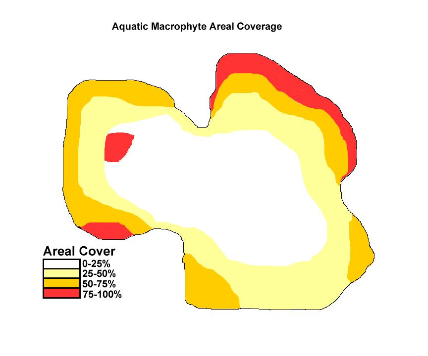
3 TASK 4: Mapping the location of aquatic plants For this task you must take a tour of the lake shoreline and observe areas of the lake where aquatic vegetation is present; either below, near or at the surface. The elements listed below (and in Task 5) should be considered options for monitoring depending on project objectives or the observer s level of interest and/or training. One or all of them may be combined during a single trip or done on successive trips to the lake. Elements of Task 4 Slowly move the boat along the designated shoreline area and, using a clean copy of the lake map, draw a sketch showing the extent of the vegetation beds. Note whether plants are below or near the surface (submerged), at the surface (floating), or projecting above the surface (emergent). Using the scale on the map, estimate the length and width of significant plant beds. If available, a rangefinder device can be useful for this exercise. For any significant plant beds estimate the areal coverage of the plants as either sparse (0-25% cover), moderate (>25-50% cover), dense (>50-75% cover), or very dense (>75-100% cover). [NOTE: Cover is determined by imagining that all of the vegetation in the water column, at any given site, is projected to the surface and then approximating what percentage of the surface would be covered with vegetation.] Areas of differing coverage can be denoted on the map as follows: sparse areas with no markings, moderate areas with stippling, dense areas with hatched lines, and very dense areas with cross-hatched lines (see attached example). To keep a record of which species (or type) of plants occur most commonly within the lake (frequency of occurrence) first mark a series of planned observation sites on the map. This is best done before going out in the boat. Thirty (30) or more sites, depending on the size of the lake, should be marked at fairly uniform intervals throughout the lake (both shallow and deeper plant beds) to get a representative sampling. During the course of the shoreline survey, stop at each of these sites and record (sample form attached) which species (or type) are located at that site. Frequency of occurrence for each plant species can be calculated as a percentage of the total number of sites observed. A more specific mapping of the exact location of plant species (or types) can be performed during the shoreline survey by marking on a copy of the lake map. It is best to develop a code for each species or type in order to 3
4 fit them on the map. If the same type of mapping is planned for future dates make sure that the code is maintained or confusion will result. TASK 5: Collection of plant species and estimation of plant density at a specific site Locate an appropriate sampling site (preferably with the aid of a monitoring program official) and establish an imaginary transect line perpendicular from the shore. Following along this line at specific intervals, cast a weighted rake to the lake bottom and pull up aquatic vegetation. This vegetation will be sorted and you will make a qualitative estimation of the percentage and density of plant types found. Specimens of each type will be bagged for shipment to a botanist for identification. Elements of Task 5 Move to the designated sampling position and anchor. Measure the lake depth using a fathometer, leadline, or calibrated anchor line. Confirm that the throwing line is securely attached to the weighted rake at one end and to the boat at the other end. Facing the shore, pitch the weighted rake straight ahead (the 12:00 position) to a distance about six feet from the boat. Allow the rake to settle to the lake bottom and then pull the line so that the teeth of the rake drag along the bottom of the lake. Bring the rake back into the boat, remove all the vegetation trapped on the teeth, and sort the different plant types into separate piles so that they can be identified as 1, #2, etc. Mark on the data sheet (example attached) the approximate percentage of each plant type found, making sure the percentages add to 100%. Repeat the raking procedure at the 3:00, 6:00, and 9:00 positions; each time sorting the vegetation types into separate piles arranged so that they can be identified as 1, #2, etc. and marking the percentages for each haul on the data sheet. Mark on the data sheet the rate of recovery of each of the plant types. [See chart on the attached example data sheet. If a plant type is found in all four casts and each time the teeth of the rake are full, mark 5. If it is found moderately on all four casts, mark 4. If the plant type was found in only three of the four casts, mark 3, and so on.] 4
5 Remove a few healthy specimens from each of the sorted piles of plant types, shake off excess water and place them in a properly labeled collection bag for processing on shore. Avoid collecting immature plants and, if possible, include the entire plant as the specimen (i.e., stems, leaves, roots, flowers and/or fruits). By doing the survey during the peak of the growing season the flowers and/or mature fruits can be collected. These are important for identification of the plants. Move the boat along the transect line to the next sampling point and repeat the above elements. The total number of sampling points should be predetermined, preferably with aid from a monitoring program official. If practical, keep all collected plant fragments in the boat for proper disposal on land; many nuisance species reproduce from fragments. TASK 6: Delivery of samples and forms This task requires packing and forwarding the plant type samples to a program botanist for identification. In addition, the data sheet with the density rating for each plant type and sampling observation must be sent to the coordinating organization for analysis. Elements of Task 6 Once you have returned to shore, remove each specimen from the collection bag and carefully wrap it in several layers of paper (newspaper should be satisfactory). Submerge the wrapped specimen in water and return it to the collection bag, ensure that the bag is properly marked, and seal the bag securely. Refrigerate bags in the interim before delivery to a program botanist. They may be kept for several days in this manner. Deliver the specimens as soon as possible to a program botanist for identification. Send copies of the sampling information data sheets to the program coordinator for analysis. 5
6 AQUATIC MACROPHYTE OBSERVATION TALLY SHEET LAKE/POND: DATE: COLLECTORS: TOTAL OBSERVATIONS: SPECIES NAME OBSERVATION TALLYS TOTAL 6
7 AQUATIC MACROPHYTE FREQUENCY OF OCCURRENCE (# Observations / Total Observations x 100) Lake/Pond: Date: Collectors: Species Name 0-20% 21-40% 41-60% 61-80% % 7
8 Aquatic Macrophyte Sampling Form Lake Name: Transect Line No. Density Rating Chart Sampling Date: Rake Recovery of Density Descriptive Position on Transect Line Aquatic Plant Type Rating Term Sampling Time: Taken in all 4 Casts 5 Dense Names of Volunteers: (teeeth of rake full) Taken in 4 casts 4 Heavy Lake Depth Taken in 3 casts 3 Moderate Taken in 2 casts 2 Scattered Taken in 1 cast 1 Sparse 12 o'clock position % of Recovery 3 o'clock position % of Recovery 6 o'clock position % of Recovery 9 o'clock position % of Recovery Density Rating (1-5) 1 TOTAL 100% 100% 100% 100% 8
9 9
10 AQUATIC PLANT IDENTIFICATION TEXTS Fassett, N.C A Manual of Aquatic Plants. University of Wisconsin Press. Madison. [Currently out of print, but may be available at some libraries.] Hellquist, C.B. and Crow, G.E Aquatic Vascular Plants of New England: Parts 1-8. New Hampshire Agricultural Experiment Station. University of New Hampshire. Durham. [Best bet for New England identifications. Each volume covers from one to five families of aquatic plants. Unfortunately, not all families of aquatic plants are covered, but it does include most common ones.] Hotchkiss, N Common Marsh, Underwater, and Floating- leaved Plants of the United States and Canada. Dover Publications, Inc. New York. AQUATIC PLANT IDENTIFICATION AND MONITORING ASSISTANCE Contact: Rick McVoy Dept. of Environmental Protection Division of Watershed Management 627 Main Street, 2 nd Floor Worcester, MA Tel. No / Richard.Mcvoy@state.ma.us 10
Aquatic Plant Point-Intercept Survey for Cates Lake, Scott County, Minnesota
 American Lotus in Cates Lake, Scott County, Minnesota, 2016 Aquatic Plant Point-Intercept Survey for Cates Lake, Scott County, Minnesota [Plant Survey Conducted August 29, 2016] Prepared for: Prior Lake-Spring
Chateaugay Lakes Milfoil Control Program
 Chateaugay Lakes Milfoil Control Program Summary of Activities and Findings for June August 29 Prepared By: Daniel L. Kelting Executive Director Adirondack Watershed Institute Paul Smith's College P.O.
Aquatic Plant Point-Intercept Survey for Pike Lake, Scott County, Minnesota
 Campers on Pike Lake, Scott County, Minnesota, 2015 Aquatic Plant Point-Intercept Survey for Pike Lake, Scott County, Minnesota [Plant Survey Conducted August 24, 2015] Prepared for: Prior Lake/Spring
Management of Hybrid Watermilfoil (Myriophyllum sibericum x spicatum) using Diver Assisted Suction Harvesting
 using Diver Assisted Suction Harvesting") 2527 Lake Ottawa Road Iron River, MI 49935 906.284.2198 Management of Hybrid Watermilfoil (Myriophyllum sibericum x spicatum) using Diver Assisted Suction Harvesting Lake Ellwood, Florence, WI - 2014 Final
2527 Lake Ottawa Road Iron River, MI 49935 906.284.2198 Management of Hybrid Watermilfoil (Myriophyllum sibericum x spicatum) using Diver Assisted Suction Harvesting Lake Ellwood, Florence, WI - 2014 Final
Natural Bridges Field Trip Activity
 Natural Bridges Field Trip Activity This is due in class on MONDAY- March 1 - not in sections! Name TA: NOTE ON THE GRADING OF THIS ASSIGNMENT: Many of the questions below (especially in the tidepool part)
Terry s Fishing Tips. Fly Fishing Lakes in the Peace Country
 Terry s Fishing Tips Fly Fishing Lakes in the Peace Country Getting ready for Spring Fishing! Before you set out on a spring fishing trip there are a few things you need to take care of: - Pull out and
Aquatic Invasive Species : Update on AIS related efforts at Deep Creek Lake, Maryland
 Aquatic Invasive Species : Update on AIS related efforts at Deep Creek Lake, Maryland Presentation to the DCL Property Owners Association August 19, 2017 Julie Bortz Maryland Department of Natural Resources
Welcome to Paddle for the Edge!
 Welcome to Paddle for the Edge! Thank you for volunteering to conduct a survey of the Barnegat Bay s shorelines. As a citizen scientist, you become part of a project to collect critical data about current
13 Ways to Run Out of Air & How Not to
 DAN S SMART GUIDE TO AIR CONSUMPTION 13 Ways to Run Out of Air & How Not to The most common ways to run out of air. How much air do you really need? Safety tips to prevent emergencies. DAN S SMART GUIDE
Osoyoos Lake Aquatic Plant Mapping
 Osoyoos Lake Aquatic Plant Mapping AquaTechnex, LLC Presented to Okanogan County NWCB by PO Box 30824 Bellingham WA, 98228 www.aquatechnex.com Introductions Myriophyllum spicatum or Eurasian Milfoil has
Aquatic Plants of the Three Lakes
 Aquatic Plants of the Three Lakes Chris Doyle, CLM Senior Aquatic Biologist/Water Quality Program Supervisor Allied Biological, Inc. 580 Rockport Road Hackettstown, NJ 07840 Phone: 908-850-0303 E-mail:
Starry Stonewort in Silver Lake Washington County, WI BRAD STECKART AIS COORDINATOR FOR WASHINGTON AND WAUKESHA COUNTIES
 Starry Stonewort in Silver Lake Washington County, WI BRAD STECKART AIS COORDINATOR FOR WASHINGTON AND WAUKESHA COUNTIES Brad Steckart -AIS coordinator for Washington and Waukesha Counties -Graduated from
Florida s Wildlife Contingency Plan for Oil Spill Response June 2012 Carcass Collection Protocols. Carcass Collection Protocols
 The purpose of this protocol is to describe the methods and materials required to collect wildlife carcasses from the field as part of response and NRDA activities during an oil spill incident. The majority
MEMORANDUM Comfort Lake-Forest Lake Watershed District
 MEMORANDUM Comfort Lake-Forest Lake Watershed District To: Board of Managers Date: December 7, 2016 From: Mike Kinney Subject: 2016 Watercraft Inspections and AIS Report Summaries Watercraft Inspection
FLOW MEASUREMENT (SEMI-SUBMERGIBLE OBJECT METHOD)
") Page 83 of 232 OKLAHOMA CONSERVATION COMMISSION WATER QUALITY DIVISION STANDARD OPERATING PROCEDURE FLOW MEASUREMENT (SEMI-SUBMERGIBLE OBJECT METHOD) Page 84 of 232 1.0 PROCEDURAL SECTION 1.1 Scope and
Page 83 of 232 OKLAHOMA CONSERVATION COMMISSION WATER QUALITY DIVISION STANDARD OPERATING PROCEDURE FLOW MEASUREMENT (SEMI-SUBMERGIBLE OBJECT METHOD) Page 84 of 232 1.0 PROCEDURAL SECTION 1.1 Scope and
Quantitative Freshwater Mussel Survey Date Prepared: 11/20/2017
 PARTNERSHIP FOR THE DELAWARE ESTUARY Science Group Quantitative Freshwater Mussel Survey Date Prepared: 11/20/2017 Prepared By: Kurt Cheng Suggested Citation: Cheng, K. 2017. Quantitative Freshwater Mussel
Eurasian water-milfoil (Myriophyllum spicatum) SCUBA Dive Monitoring Survey Sand Bar Lake WBIC: Bayfield County, Wisconsin
 SCUBA Dive Monitoring Survey Sand Bar Lake WBIC: Bayfield County, Wisconsin") Eurasian water-milfoil (Myriophyllum spicatum) SCUBA Dive Monitoring Survey Sand Bar Lake WBIC: 2494900 Bayfield County, Wisconsin 6ft EWM Towers with Rooted Branch Preparing to Fall Off (Berg 2016) EWM
Eurasian water-milfoil (Myriophyllum spicatum) SCUBA Dive Monitoring Survey Sand Bar Lake WBIC: 2494900 Bayfield County, Wisconsin 6ft EWM Towers with Rooted Branch Preparing to Fall Off (Berg 2016) EWM
Summary of Diver Assisted Suction Harvesting Efforts. Lake Ellwood Florence County, WI
 2527 Lake Ottawa Road Iron River, MI 49935 906.284.2198 Summary of Diver Assisted Suction Harvesting Efforts Lake Ellwood Florence County, WI 2015 WDNR Mechanical Harvesting Permit Annual Report Permit
Creek Trash Assessment (CTA) Methodology (Demonstration: Mill Run Creek, Cheltenham, Pa.)
 Methodology (Demonstration: Mill Run Creek, Cheltenham, Pa.)") Creek Trash Assessment (CTA) Methodology (Demonstration: Mill Run Creek, Cheltenham, Pa.) Mill Run Creek emerges from a storm sewer in Philadelphia to an open creek in Cheltenham. The Creek downstream
Creek Trash Assessment (CTA) Methodology (Demonstration: Mill Run Creek, Cheltenham, Pa.) Mill Run Creek emerges from a storm sewer in Philadelphia to an open creek in Cheltenham. The Creek downstream
Current Status and Management Recommendations for the Fishery in the Cloverleaf Chain of Lakes
 Current Status and Management Recommendations for the Fishery in the Cloverleaf Chain of Lakes Jason Breeggemann Senior Fisheries Biologist Wisconsin Department of Natural Resources Outline DNR fisheries
LAKE JESUP VEGETATION MAPPING: AN INTER-AGENCY COLLABORATION. Lakshmi Sankaran, GISP Public Works Department, Seminole County
 LAKE JESUP VEGETATION MAPPING: AN INTER-AGENCY COLLABORATION Lakshmi Sankaran, GISP Public Works Department, Seminole County LAKE JESUP Area - 12 sq miles Shoreline - 53 miles Watershed - 136 sq miles
Restoration of Eelgrass to Upper Casco Bay: Feasibility Tests in Hilary A. Neckles US Geological Survey Augusta, ME
 Restoration of Eelgrass to Upper Casco Bay: Feasibility Tests in 2015 Hilary A. Neckles US Geological Survey Augusta, ME hneckles@usgs.gov Robert J. Orth Eelgrass: Zostera marina * marine flowering plant
Smart Guide. How To Avoid. Running Out of Air
 Smart Guide How To Avoid Running Out of Air 1 DAN S SMART GUIDE TO AIR CONSUMPTION Our self-contained underwater breathing apparatuses are only useful as long as the cylinder contains sufficient breathing
HOW TO DIG A TEST PIT
 HOW TO DIG A TEST PIT An archaeological test pit is a small 1m by 1m trench dug in a series of layers, or spits, to a depth of approximately 1m. The archaeological materials collected from these layers
Eelgrass and Macroalgae Presence/Absence Preliminary Surveys BHP Proposed Grays Harbor Potash Export Facility A Task 400
 Memorandum 40600-HS-MEM-55036 Revision 0 Date: 26 July 2018 Subject: Eelgrass and Macroalgae Presence/Absence Preliminary Surveys BHP Proposed Grays Harbor Potash Export Facility A17.0202.00 Task 400 INTRODUCTION
Nearshore Habitat Mapping in Puget Sound Using Side Scan Sonar and Underwater Video
 Nearshore Habitat Mapping in Puget Sound Using Side Scan Sonar and Underwater Video Dana Woodruff, Paul Farley, Amy Borde, John Southard, Ron Thom Battelle Marine Sciences Laboratory Jim Norris Marine
Nicholas Brown. 31 Bennett Rd Wolfeboro NH Application submitted
 Nicholas Brown 31 Bennett Rd Wolfeboro NH 03894 603-856-5454 Nick4634@gmail.com Application submitted 8-12-2017 Description of proposed project A. General Methodology The site located approximately 600
Lake wide Milfoil Management Efforts
 Lake Winnipesaukee Lake wide Milfoil Management Efforts Gilford Island Association Winter Meeting March 5, 2016 Presented by: Patricia Tarpey Lake Winnipesaukee Association Gilford Conservation Commission
Program Indicator: The students will compare/contrast habitats and adaptations of plant and animals in salt water (brackish) habitat.
 habitat.") Activity: Seining Grade Level: Grade 5 Major Emphasis: Salt Water Habitat Major Curriculum Area: Science Related Curriculum Objectives: Refer to Outdoor Education Curriculum Matrix 3-5: Career Education
Activity: Seining Grade Level: Grade 5 Major Emphasis: Salt Water Habitat Major Curriculum Area: Science Related Curriculum Objectives: Refer to Outdoor Education Curriculum Matrix 3-5: Career Education
Before you start sampling, be sure to read
 6. DISSOLVED OXYGEN MONITORING: MONITORING: Using the Titration Method Before you start sampling, be sure to read the following pages to familiarize yourself with the equipment and the procedures that
City of Pittsfield Harbormaster APPLICATION FOR AN INDIVIDUAL MOORING PERMIT
 City of Pittsfield Harbormaster APPLICATION FOR AN INDIVIDUAL MOORING PERMIT INSTRUCTIONS: This application may only be used for requests to place lake moorings. This application must be completed in its
Level 3 Skills Course
 Level 3 Skills Course This course develops seamanship and leadership in multi-day touring. The participant in Level-3 will develop practical leadership, risk assessment, decision-making, judgment, group
MIDDLE FORK RESERVOIR Wayne County 2004 Fish Management Report. Christopher C. Long Assistant Fisheries Biologist
 MIDDLE FORK RESERVOIR Wayne County 2004 Fish Management Report Christopher C. Long Assistant Fisheries Biologist FISHERIES SECTION INDIANA DEPARTMENT OF NATURAL RESOURCES DIVISION OF FISH AND WILDLIFE
ISAF OFFSHORE SPECIAL REGULATIONS Appendix J
 Page - 95 - APPENDIX J CATEGORY 5 SPECIAL REGULATIONS for inshore races Category 5 Special Regulations are intended for use in short races, close to shore in relatively warm and protected waters where
ATTACHMENT F. Minnesota Department of Natural Resources. Marsh Lake Ecosystem Restoration Project
 ATTACHMENT F Minnesota Department of Natural Resources Marsh Lake Ecosystem Restoration Project Mussel Rescue and Translocation Plan for Pomme de Terre River Restoration (Prepared June, 2016) Attachment
Kerr Lake Vegetation Survey. October November Report submitted by NC State University. Background
 Kerr Lake Vegetation Survey October November 2012 Report submitted by NC State University Background Hydrilla (Hydrilla verticillata) is a non-native invasive submersed aquatic plant. This plant was first
Hydrographic Surveying Methods, Applications and Uses
 Definition: Hydrographic Surveying Methods, Applications and Uses It is the branch of surveying which deals with any body of still or running water such as a lake, harbor, stream or river. Hydrographic
2014 Threatened and Endangered Fish Survey of. East Loon Lake and West Loon Lake. Lake County, Illinois
 2014 Threatened and Endangered Fish Survey of East Loon Lake and West Loon Lake Lake County, Illinois Prepared by Integrated Lakes Management 120 LeBaron St. Waukegan, IL 60085. Chris Ryan Chris Rysso
Factors Affecting the Reproduction of Bluegill Bream and Largemouth Black Bass in Ponds
 CIRCULAR NO. 87FERAY14 FEBRUARY 1943 Factors Affecting the Reproduction of Bluegill Bream and Largemouth Black Bass in Ponds H-. S. SWINGLE, Fish C'ulturist and E. V. SMITH, Associate Botanist AGRICULTURAL
DURING ALL ACTIVITIES, MAKE SURE YOU DON T DAMAGE THE REEF OR OTHER MARINE LIFE!
 Fish surveys Long term volunteers can take part in the fish surveys. These surveys are the most complex research we do with volunteers. You have to learn a lot, but in return you will receive a lot of
TRI KIDS RACE WEEKEND GUIDE. Everything you need to know for Race Weekend! TRi KiDS Oakville July 5, Appleby College
 TRi KiDS Oakville July 5, 2015 Appleby College 540 Lakeshore Rd West Oakville, ON TRI KIDS RACE WEEKEND GUIDE Everything you need to know for Race Weekend! SWiM, BiKE, RUN! TRi KiDS Oakville is this weekend!
ADA Access Standards for Swimming Pools, Wading Pools, and Spas
 ADA Access Standards for Swimming Pools, Wading Pools, and Spas The sports, places of amusement, and outdoor developed areas subcommittees each provided recommendations in this area. The recommendations
NEED FOR SUPPLEMENTAL BATHYMETRIC SURVEY DATA COLLECTION
 305 West Grand Avenue, Suite 300 Montvale, New Jersey 07645 Phone 201.930.9890 Fax 201.930.9805 www.anchorqea.com M EMORANDUM To: Caroline Kwan and Nica Klaber U.S. Environmental Protection Agency Region
PROPOSAL ADDENDUM: SAFETY GUIDELINES Oregon Association of Rowers July 2015
 INTRODUCTION These Safety Guidelines are to help educate members regarding their responsibility for their own safety at all times. All OAR members are expected to promote safe and responsible rowing at
Use of Conservation Moorings as a Component of Eelgrass Restoration in two Massachusetts Harbors
 Use of Conservation Moorings as a Component of Eelgrass Restoration in two Massachusetts Harbors Massachusetts Bays Program Division of Marine Fisheries Jay Baker, Tay Evans, Mass Bays Program MarineFisheries
MAKE YOUR SAMPLE COUNT! A PRIMER ON COLLECTING QUALITY, REPRESENTATIVE SAMPLES
 TURF MATTERS I BY SAM FERRO President Turf Diagnostics & Design DIAGNOSTIC SPECIAL FOCUS SERVICES REPORT MAKE YOUR SAMPLE COUNT! A PRIMER ON COLLECTING QUALITY, REPRESENTATIVE SAMPLES "Follow the guidelines
TOP:001.3 U.S. Fish and Wildlife Service TECHNICAL OPERATING PROCEDURE
 TOP:001.3 March 12, 2015 U.S. Fish and Wildlife Service Marquette Biological Station 3090 Wright Street Marquette, Michigan 49855 U.S.A. and U.S. Fish and Wildlife Service Ludington Biological Station
Seventeenth Coast Guard District Auxiliary Policy Directive 01-07
 Commander Seventeenth Coast Guard District Director of Auxiliary PO Box 25517 Juneau, AK 99802-5517 Staff Symbol: dpa Phone: 907-463-2252 Fax: 907-463-2256 Email: Robert.C.Gross@uscg.mil Seventeenth Coast
Ross Barnett Reservoir 2018
 Ross Barnett Reservoir 18 Reel Facts Ryan Jones Fisheries Biologist Ryanj@mdwfp.state.ms.us (61) 89-341 General Information: Ross Barnett Reservoir is a 33, acre impoundment of the Pearl River. It consists
Aquatic Plant Management and Importance to Sport Fisheries
 Aquatic Plant Management and Importance to Sport Fisheries Presentation to Michigan Inland Lakes Convention May 2014 Mike Maceina Professor Emeritus School of Fisheries, Aquaculture, and Aquatic Sciences
Mentoring in the USCG Auxiliary Boat Crew Program Coxswain Mentoring Template
 Notes: 1. When there is no reading assignment specified, the entire chapter contains references to the topic. 2. The study questions in the Qualification Guide should be completed for each task. Boat Crew
Understanding Types and Benefits of Fish Habitat
 Understanding Types and Benefits of Fish Habitat Leonard Dane Fisheries Biologist Deuchler Environmental, Inc. ILMA POD April 14, 2015 Wauconda, IL Importance of Fish Habitat What is fish habitat? those
SEA GRANT PROGRESS REPORT
 SEA GRANT PROGRESS REPORT Project Title: The relationship between seasonal migrations of berried female lobster Homarus americanus, egg development and larval survival. Principal Investigator: Winsor H.
Fish Assessment for Sanctuary Pond October 10, 2005
 83 Ambrogio Dr, Suite K Gurnee, IL 60030 8847-244-6662 847-244-0261 fax www.lakesmanagement.com Fish Assessment for Sanctuary Pond October 10, 2005 Prepared For: Dr. Mike Sands Executive Director Liberty
TRI KIDS RACE WEEKEND GUIDE. Everything you need to know for Race Weekend! TRi KiDS Niagara August 23, Ridley College
 TRi KiDS Niagara August 23, 2015 Ridley College 2 Ridley Road, St Catharines, ON TRI KIDS RACE WEEKEND GUIDE Everything you need to know for Race Weekend! SWiM, BiKE, RUN! TRi KiDS Niagara is this weekend!
STREAM Girls field notebook
 s STREAM Girls field notebook Welcome...... to your stream! Trout Unlimited is excited to offer you and other Girl Scouts the chance to really get to know your home waters. Over the next three days, you
TRI KIDS RACE WEEKEND GUIDE. Everything you need to know for Race Weekend! TRi KiDS Milton September 6, Milton Sports Centre
 TRi KiDS Milton September 6, 2015 Milton Sports Centre 605 Santa Maria Blvd. Milton, ON TRI KIDS RACE WEEKEND GUIDE Everything you need to know for Race Weekend! SWiM, BiKE, RUN! TRi KiDS Milton is this
Fish Survey of Arctic Lake (ID # ), Scott County, Minnesota in 2012
, Scott County, Minnesota in 2012") Snapping Turtle from Arctic Lake, September 2012 Fish Survey of Arctic Lake (ID #70-0085), Scott County, Minnesota in 2012 Survey Dates: September 18-20, 2012 MnDNR Permit Number: 18362 Prepared for: Shakopee
Snapping Turtle from Arctic Lake, September 2012 Fish Survey of Arctic Lake (ID #70-0085), Scott County, Minnesota in 2012 Survey Dates: September 18-20, 2012 MnDNR Permit Number: 18362 Prepared for: Shakopee
Rescue Technician: Surface Water Rescue I/II
 Rescue Technician: Surface Water Rescue I/II Skill Sheet Package Based on NFPA 1006: Standard for Technical Rescue Professional Qualifications,. Alabama Fire College February 2015 REVISED 02/10/2017 Alabama
Survey Technique for Underwater Digital Photography with Integrated GPS Location Data
 Survey Technique for Underwater Digital Photography with Integrated GPS Location Data Tim Siwiec: United States Environmental Protection Agency Abstract This survey technique is an inexpensive method of
Dive Operations Plan for Personal Submersibles. Revision
 Dive Operations Plan for Personal Submersibles Revision 2011.1 1 Table of Contents 1 EVENT...3 1.1 Summary of planned dive...3 1.1.1 PSUBS Guidelines...3 1.1.2 Maximum dive depth planned...3 1.1.3 Number
Properties. terc.ucdavis.edu 8
 Physical Properties 8 Lake surface level Daily since 1900 The lowest lake level on record was 6,220.26 feet on Nov. 30, 1992. Since 1900, lake level has varied by more than 10 feet. Lake level typically
TEXAS A&M WATER SKI CLUB BOAT DRIVER S MANUAL
 TEXAS A&M WATER SKI CLUB BOAT DRIVER S MANUAL Effective 10-8-13 The purpose of this manual is to teach the basic duties and responsibilities of a Texas A&M Water ski Club boat driver. This information
MaxDepth Aquatics, Inc.
 MaxDepth Aquatics, Inc. Hydroacoustic Survey and Point Sampling of Macrophytes In Diamond Lake 2009 A Report to the Partners for Umpqua Rivers Roseburg, OR And the Umpqua National Forest Roseburg, OR By
Rocky Investigations. Level. Activities for primary students on a rocky shore or platform. Key questions. What you need. Key outcomes.
 Rocky Investigations Level Between 2 and 5 Key questions What can you find out about rock pools and the life in them? How do we feel about the rock pools? Key outcomes Observe features of rock pools and
For more information or permission to reprint slides, please contact Donna Milligan at 1
 For more information or permission to reprint slides, please contact Donna Milligan at milligan@vims.edu 1 For more information or permission to reprint slides, please contact Donna Milligan at milligan@vims.edu
1. Indicate the number of employees and supervisors who will be working on the site. 5-10
 28068 Site Description continued - Describe the natural vegetation --- ground cover, trees, shrubs --- and any proposed changes. Describe the location of any estuarine, riparian, or wetlands and any noticeable
S/Y MORSKI ZEKAN TECHNICAL INFORMATION
 S/Y MORSKI ZEKAN TECHNICAL INFORMATION Cabins: 3 Toilets: 1 Max. Persons: 8 (6+2) LOA: 11,35 m Beam: 3,80 m Draft: 1,95 m Engine: Volvo 28HP Water tanks: 360 L Fuel tank: 150 L Anchor windlass Speed and
Imagine that you can see a side view of a wave as it approaches a beach. Describe how the wave changes as the wave approaches the beach.
 Geology 101 Name Reading Guide for Ch. 19: Shores and Coastal Processes (p. 612) Waves, Currents, and Tides (p. 614) Waves and Currents (p. 614) Imagine that you can see a side view of a wave as it approaches
Deer and Deer Management in Central New York: Local Residents Interests and Concerns
 Deer and Deer Management in Central New York: Local Residents Interests and Concerns NYS Department of Environmental Conservation Division of Fish, Wildlife & Marine Resources and the Human Dimensions
Procedure for Small Boat Operator Qualification
 Procedure for Small Boat Operator Qualification Introduction Prior to being qualified as a small boat operator, prospective users will be asked to fill out a questionnaire (contact RFO for copy of questionnaire)
05 Boat Handling. Captain
 05 Boat Handling Competence (Skills) Knowledge, Understanding and Proficiency Level Required Boat handling theory and techniques Coxswain Crew RQ RQ Describe the forces acting on a vessel while manoeuvering
Lynx Protection Zone and Trap Restrictions
 Lynx Protection Zone and Trap Restrictions Canada lynx are a federally listed Threatened Species. There is no open season for the trapping or hunting of lynx in Maine. Department biologists have confirmed
Pontoon Slide Owner s Manual
 Pontoon Slide Owner s Manual WWW.RAVESPORTS.COM Copyright 2018 All rights reserved. No part of this publication may be reproduced or transmitted in any form or by any means, electronic or mechanical, including
Ross Barnett Reservoir 2019
 Ross Barnett Reservoir 19 Reel Facts Ryan Jones Fisheries Biologist Ryan.Jones@wfp.ms.gov (1) 89-31 General Information: Ross Barnett Reservoir is a 33, acre impoundment of the Pearl River. It consists
SPECIALISED SERVICES. Kris Vlaeminck, Jan De Nul Group, Luxembourg, explains the use of dredging vessels on the Macedon Project in Australia.
 SPECIALISED SERVICES Kris Vlaeminck, Jan De Nul Group, Luxembourg, explains the use of dredging vessels on the Macedon Project in Australia. Figure 1. Shore approach for the Macedon project in Australia.
Divemaster. Divemaster
 Divemaster OVERVIEW AND QUALIFICATIONS The NAUI Divemaster rating is the highest NAUI leadership level certification with the exception of instructor. The program is designed to train experienced and knowledgeable
RECREATIONAL PONDS AND LAKES
 RECREATIONAL PONDS AND LAKES POND ECOLOGY AQUATIC PLANTS & FISH F.S. Conte Department of Animal Science University of California Davis Photos By Flickr AQUATIC PLANTS POND HEALTH Chemical Recycling Oxygen
Reef Watch Guidelines
 Reef Watch Guidelines What is Reef Watch? Reef watch is a simple one-dive-one-survey method to record the health of coral reefs. The method is easily learnt and it is even easier to participate in the
DIVING AS A TECHNIQUE TO CONTROL EXOTIC AQUATIC PLANTS: THE WEED CONTROL DIVER PROGRAM
 DIVING AS A TECHNIQUE TO CONTROL EXOTIC AQUATIC PLANTS: THE WEED CONTROL DIVER PROGRAM PREPARED BY: NEW HAMPSHIRE DEPARTMENT OF ENVIRONMENTAL SERVICES EXOTIC SPECIES PROGRAM 29 HAZEN DRIVE CONCORD, NH
STATIONARY SPRINKLER IRRIGATION SYSTEM
 STATIONARY SPRINKLER North Carolina Cooperative Extension Service North Carolina State University STATIONARY SPRINKLER General Guidelines Operating an irrigation system differently than assumed in the
1. Distribute the activity sheet, and allow 20 minutes for the first use.
 A LOCAL WAY OF LEARNING Title: MISSING MANGROVE MESSAGE Author: Eulalie R. Rivera Elementary School Environmental Education Team Grade Level: 4-6 Concepts: 2.Ecosystem 6.Resources 9.Change Disciplines:
Mud Bay SLELO-PRISM Water Chestnut & Hydrilla Surveillance 2012
 St. Lawrence Eastern Lake Ontario Partnership for Regional Invasive Species Management Mud Bay Water Chestnut & Hydrilla Surveillance 2012 June 27 th (Water Chestnut) & August 2 (Hydrilla), 2012 Figure
City of Pittsfield HARBORMASTER RULES AND REGULATIONS on docks
 City of Pittsfield HARBORMASTER RULES AND REGULATIONS on docks Definitions Dock: Any permanently fixed or floating structure extending from the upland into the water, capable of use for vessel mooring
NEW MEMBERS HANDBOOK GENERAL MEMBERSHIP INFO:
 NEW MEMBERS HANDBOOK WELCOME!! We look forward to getting to know you and hope that this manual helps you know more about us. We love having people join our group and share in our passion for rowing. We
0460 GEOGRAPHY. 0460/41 Paper 4 (Alternative to Coursework), maximum raw mark 60
, maximum raw mark 60") CAMBRIDGE INTERNATIONAL EXAMINATIONS Cambridge International General Certificate of Secondary Education MARK SCHEME for the May/June 2015 series 0460 GEOGRAPHY 0460/41 Paper 4 (Alternative to Coursework),
CAMBRIDGE INTERNATIONAL EXAMINATIONS Cambridge International General Certificate of Secondary Education MARK SCHEME for the May/June 2015 series 0460 GEOGRAPHY 0460/41 Paper 4 (Alternative to Coursework),
2017 Water Safety Manual. Presented by:
 2017 Water Safety Manual Presented by: 1 WATER EMERGENCY SAFETY PLAN This Water Emergency Safety Plan was developed to aid in the response to injuries or illnesses on the water during the Partners In Education
New Hampshire Marine Aquaculture License Application
 New Hampshire Marine Aquaculture License Application Submitted by: Christopher Gallagher 1 Hoyts Lane Newburyport, MA 01950 Cell: 978-518-2876 Email: tikg@comcast.net June 13, 2018 Site name: Little Bay
Overview. What are Corals?
 Overview Coral Reefs extend back over 500 m.y. Grow in tropical seas with normal salinity Support a great variety of plant and animal life Cover less than 0.2% of sea floor Contain about 25% of marine
Chapter 5 Decompression, Dive Tables, and Dive Computers
 Chapter 5 Decompression, Dive Tables, and Dive Computers Nitrogen and Diving 1. If the partial pressure of nitrogen in the air you are breathing is greater than the pressure of nitrogen in your body, your
Steel City Dragon-Boat Program & Steel City Dragons Dragon-Boat Racing Team Revised March 2013 SAFETY PROTOCOL. Dragon Boat Operating Safety
 Steel City Dragon-Boat Program & Steel City Dragons Dragon-Boat Racing Team Revised March 2013 Dragon Boat Operating Safety Minimum safety protocol for the safe operation of Dragon Boat during all on-water
Crawford Reservoir. FISH SURVEY AND MANAGEMENT INFORMATION Eric Gardunio, Fish Biologist Montrose Service Center
 FISH SURVEY AND MANAGEMENT INFORMATION General Information: Crawford Reservoir is a popular fishery that provides angling opportunity for yellow perch, channel catfish, northern pike, rainbow trout, black
Field survey of the fish populations of the lower Ngaruroro River
 Field survey of the fish populations of the lower Ngaruroro River Glenn Maclean March 2014 HBRC Publication No. 4873 Report No. RM16-54 CMB 93, RD 2, Owhango 3990 E glenn@technicallytrout.co.nz W www.technicallytrout.co.nz
WATER SAFETY WATER SAFETY H F A O E Y H F S 2 E T E S O Y S H 2 A E Y 2 H F O T A
 Task Card 1 WATER WORDS There are many words associated with water. When you are reading our pages on water safety you will come across some. See if you can match the following words with their meanings.
Idaho Fire Service Technology Fire Fighter II
 ICS Skill Requirements Skill Sheet: 1 STANDARD: 6.1.2 TASK: Organize, coordinate, and function within an incident management system. PERFORMANCE OUTCOME: The candidate shall be able to determine the need
Fluids PROCEDURE. 1. Record the mass of the block of wood. 2. Record the mass of the beaker of water (without the block).
.") Fluids This format for this experiment will be a little different from what you re used to. Instead of spending all your time at one station interacting with a single apparatus you ll be spending 10-15
Fluids This format for this experiment will be a little different from what you re used to. Instead of spending all your time at one station interacting with a single apparatus you ll be spending 10-15
Only launch your boat once you have a clear understanding of the most up-to-date weather forecast.
 Weather and Tides Observing the Weather Only launch your boat once you have a clear understanding of the most up-to-date weather forecast. Start with television and newspaper weather map reports; they
LaSalle Park Marina Wave Break
 LaSalle Park Marina Wave Break Federal and Municipal Environmental Assessment Background History of the Marina and LaSalle Park The LaSalle Park Marina is located in LaSalle Park at the foot of LaSalle
New Millennium Dive Expeditions
 New Millennium Dive Expeditions 15030 N Timberline Drive Reno, NV 89511 (775)850-2510 * nmde@att.net www.nmde.org Project Report July 12, 2013: Phase 1 of 2 (Phase 2: August 26 th 30 th, 2013) Supporting
Lecture Outlines PowerPoint. Chapter 15 Earth Science, 12e Tarbuck/Lutgens
 Lecture Outlines PowerPoint Chapter 15 Earth Science, 12e Tarbuck/Lutgens 2009 Pearson Prentice Hall This work is protected by United States copyright laws and is provided solely for the use of instructors