Fish Passage Assessment Report Mare Brook Culverts
|
|
|
- Kristian Hunt
- 5 years ago
- Views:
Transcription
1 Fish Passage Assessment Report Mare Brook Culverts Fish Passage Assessment Component of Mare Brook Watershed Assessment and Community Engagement Project Prepared for: FB Environmental Associates 97A Exchange Street, Suite 305 Portland, ME Prepared by: Stantec Consulting Services Inc. 30 Park Drive Topsham, ME 04086
2 Introduction Table of Contents 1.0 INTRODUCTION SURVEY PURPOSE Field Survey Extents and Elements Site Access Schedule Definitions Survey Methods UPSTREAM FISH PASSAGE ASSESSMENT CRITERIA PRELIMINARY ASSESSMENT OF UPSTREAM FISH PASSAGE MARE BROOK STUDY SITES Baribeau Drive Stream Crossing (Feature ID MB_C01) Barrow Street Stream Crossing (Feature ID MB_C02) MacMillan Drive Stream Crossing (Feature ID MB_C03) Maine Street Stream Crossing (Feature ID MB_C04) Meadowbrook Road Stream Crossing (Feature ID MB_C05) Coffin Pond Dam (Feature ID MB_D01) State Route 123 Stream Crossing (Feature ID MB_C06) Security Road Stream Crossing (Feature ID MB_C07) Samuel Adams Drive (Feature ID MB_C08) Runway Culvert (Feature ID MB_C09) Major Pope Avenue Stream Crossing (Feature ID MB_C10) Liberty Crossing Drive Stream Crossing (Feature ID MB_C11) MERRICONEAG STREAM STUDY SITES Beaver Pond Road Stream Crossing (Feature ID MS_C01) Picnic Pond Dam (Feature ID MS_D01) Purinton Road Stream Crossing (Feature ID MS_C02) SUMMARY AND DISCUSSION SUMMARY DISCUSSION REFERENCES SURVEY IMPLEMENTATION PLAN: FISH PASSAGE ASSESSMENT AT... A.1 STREAM CROSSING SURVEY FORMS... B.1 i
3 Introduction 1.0 INTRODUCTION This fish passage assessment report was prepared as part of the Mare Brook Watershed Assessment and Community Engagement Project (Project) by Stantec Consulting Services Inc. (Stantec). The objective of the preliminary fish passage assessment is to evaluate continuity of aquatic habitat in Mare Brook and Merriconeag Stream. The focus of this report is on upstream passage at culverts and other identified structures. Stantec performed the preliminary fish passage assessment as a subcontractor to FB Environmental Associates (FB Environmental). FB Environmental is performing the Project under contract to the Town of Brunswick, Maine (Town). Field surveys and reporting for the fish passage assessment were performed as described in the survey implementation plan (SIP) titled Survey Implementation Plan: Fish Passage Assessment at Mare Brook Culverts dated June 15, 2016, that was prepared by Stantec as part of the Project (Appendix A). 1.1 SURVEY PURPOSE The purpose of this fish passage assessment survey was to make visual observations and obtain limited measurements for use in the preparation of a preliminary assessment of upstream fish passage at each stream crossing for adult brook trout (Salvelinus fontinalis), which were identified in the SIP as the target species for evaluation as part of this study. This report also presents concept-level recommendations to improve upstream fish passage at the evaluated sites along Mare Brook and Merriconeag Stream Field Survey Extents and Elements Sites that were surveyed as part of this study included 11 culverts and 1 dam along the reach of Mare Brook between Baribeau Drive and tidewater and 2 culverts and 1 dam along the reach of Merriconeag Stream from Beaver Pond Road to its confluence with Mare Brook. Table 1 presents information on the 12 surveyed sites along Mare Brook, including feature identifiers (Feature IDs) assigned by Stantec, the waterway (Mare Brook), the type of feature (culvert or dam). Table 2 presents information on the three surveyed sites on Merriconeag Stream and is similar to Table 1. Figure 1 depicts the study reaches of Mare Brook and Merriconeag Stream with feature identifiers that are crossed referenced with Tables 1and Site Access Access for surveys along Mare Brook between Baribeau Drive and State Route 123 (Harpswell Road) was coordinated by FB Environmental and the Town. Surveys in this area required access 1
4 Introduction to the overlying roadway and apparent roadway easement. Access for surveys of sites along Mare Brook upstream from State Route 123 was coordinated by FB Environmental and the Town. Access for surveys of sites along Mare Brook downstream from State Route 123 and along Merriconeag Stream on land that is currently owned and/or managed by the Midcoast Regional Redevelopment Authority (MRRA) and the U.S. Navy and formerly part of Naval Air Station Brunswick was coordinated by FB Environmental and Stantec. Table 1: Surveyed Sites on Mare Brook Feature ID Feature Identifier Type MB_C01 Baribeau Drive Culvert MB_C02 Barrow Street Culvert MB_C03 MacMillan Drive Culvert MB_C04 Maine Street Culvert MB_C05 Meadowbrook Road Culvert MB_D01 Coffin Pond Dam Dam MB_C06 State Route 123 Culvert MB_C07 Security Road Culvert MB_C08 Samuel Adams Drive Culvert MB_C09 Runway Culvert Culvert MB_C10 Major Pope Avenue Culvert MB_C11 Liberty Crossing Drive Culvert Table 2: Surveyed Sites on Merriconeag Stream Feature ID Feature Identifier Type MS_C01 Beaver Pond Road Culvert MS_D01 Picnic Pond Dam Dam MS_C02 Purinton Road Culvert Schedule Stantec performed the field survey component of this study on August 18, Surveyed locations on this date included 11 culverts and 1 dam on Mare Brook and 2 culverts and 1 dam on Merriconeag Stream. The field survey was performed by a Stantec staff with relevant experience in fish passage and river and culvert hydraulics. 2

5 Revised: By: gcarpentier ( $ $ V:\1956\active\ \03_data\gis_cad\GIS\mxd\Culverts\01214_01_CulvertLocations.mxd Baribeau Drive Barrow Street MacMillan Drive Maine Street Meadowbrook Road Coffin Pond Dam Beaver Pond Road State Route 123 Security Road BRUNSWICK EXECUTIVE AIRPORT Samuel Adams Drive Runway Culvert Inlet Picnic Pond Dam Purinton Road Runway Culvert Outlet Major Pope Avenue Liberty Crossing Road Disclaimer: Stantec assumes no responsibility for data supplied in electronic format. The recipient accepts full responsibility for verifying the accuracy and completeness of the data. The recipient releases Stantec, its officers, employees, consultants and agents, from any and all claims arising in any way from the content or provision of the data. Legend Dam Location 30 Park Drive Topsham, ME USA Phone (207) Brunswick USGS Stream 0 1 inch = 0.25 miles 0.25 Miles (At page size of 11"x17") Client/Project Mare Brook Fish Passage Assessment Brunswick, Maine Figure No. 1 Title Prepared by GAC on Reviewed by MRC on _01_CulvertLocations.mxd Culvert Location Data Source 1. Aerial imagery provided by ArcGIS Online World Imagery Mapping Service (2015 NAIP) ( Culvert Location Map Map Extent Shown in Red 9/30/
6 Introduction Definitions The following conventions are used in the following descriptions of observed conditions at the study sites: 1) Directionals right and left are based on an observer facing downstream. 2) Landward and seaward are used in lieu of upstream and downstream, respectively, where tidal influence was observed during the study site visit. 3) Culvert lengths are estimated from aerial photographs. 4) Thalweg refers to the deepest part of the stream channel. 5) Inlet and outlet refer to the upstream and downstream ends, respectively, of each culvert. 6) Hydraulically perched refers to a condition where the culvert outlet invert may be at or below the downstream water surface elevation but the observed water surface elevation was above the downstream water surface elevation. Flow over the downstream end of the culvert may be supercritical (e.g., fast) for a hydraulically perched culvert outlet. 7) Abbreviations: a. CMP: corrugated metal pipe b. CPP: corrugated plastic pipe c. PCP: precast concrete pipe d. CIP: cast-in-place (used in conjunction with concrete ) Survey Methods The preliminary assessment was based on observed conditions at each stream crossing, such as perched culvert outlets, steep culverts and higher-speed flow, and very shallow water. Stream crossing survey forms were prepared and representative photograph were taken as part of the field assessment. The field survey was performed in accordance with methods described in Abbot (2012), and a Stream Crossing Survey form from Abbott (2012) was filled out for each evaluated site. Copies of the Stream Crossing Survey forms are included in Appendix B. Digital photographs were taken at each evaluated stream crossing as described in Abbott (2012). Coordinate data was obtained using existing data sources (e.g., StreamStats, Google Earth). 4
7 Preliminary Assessment of Upstream Fish Passage 1.2 UPSTREAM FISH PASSAGE ASSESSMENT CRITERIA The preliminary assessment of upstream fish passage at the evaluated sites is based on qualitative observations and limited field measurements obtained during the study site visits. The primary criteria that are used in this study to assess the potential for upstream fish passage at culverts are based on the observed depth, flow speed, and heterogeneity of hydraulic conditions at the culvert outlet, in the culvert barrel(s), and at the culvert inlet. Factors that are considered at each location include perched conditions, including those that may result from accumulation of debris. Where applicable, identified structural factors that may affect upstream fish passage, such as deteriorated and leaking culvert barrels, are also addressed. The assessed potential for upstream fish passage at each study site is assigned a qualitative rating; descriptions and brief definitions for these ratings are provided below. Not passable: this rating is assigned where upstream passage does not appear to be possible for the target fish species. Poor: this rating criteria is assigned where upstream passage may be possible during ideal conditions. Good: this rating criteria is assigned where upstream passage appears to be possible during the observed conditions during the site visit and under a narrow range of flows. Very good: this rating criteria is assigned where upstream passage appears to be possible during the observed conditions during the site visit and under a seasonal range of flow. 2.0 PRELIMINARY ASSESSMENT OF UPSTREAM FISH PASSAGE The section presents information relevant to upstream fish passage, ratings of upstream fish passage, and conceptual recommendations for improvement of upstream fish passage at the 15 evaluated sites, including 11 culverts and one dam on Mare Brook and two culverts and one dam on Merriconeag Stream. Representative photos are presented for each of the surveyed sites. 2.1 MARE BROOK STUDY SITES This section presents study findings for the 12 study sites along Mare Brook. 5
8 Preliminary Assessment of Upstream Fish Passage Baribeau Drive Stream Crossing (Feature ID MB_C01) The Baribeau Drive stream crossing of Mare Brook is at the upstream limit of the study reach of Mare Brook and consists of three culverts installed in two groups ( left group and right group ). The left culvert group consists of a 2.5-ft-diameter CMP culvert with an estimated length of 150 ft. The right culvert group consists of two 2.5-ft-diameter PCP culverts that are parallel to each other along the right side of this stream crossing. The estimated length of the two PCP culverts is approximately 100 ft. Water was flowing through each of the three culverts during the site visit. The inlets to both culvert groups are located on the west side of Baribeau Drive, with the inlet to the left culvert group location approximately 50 ft north of the inlet to the right culvert group. The outlets to the two culvert groups are approximately 10 ft apart. The culvert barrel inverts are at the stream grade at the outlets of both culvert groups. The depth of water immediately downstream from the culvert outlets was less than 0.25 ft. Gravel and cobble material are the dominant substrates in the channel downstream from the culvert outlets, and include what appears to be installed angular rock. There is no defined plunge pool. Conditions inside the culvert barrels were not observed during the site visit due to the length and relatively small diameter of the culverts. The observed depth of water at the culvert barrel inlets was approximately 0.25 ft, which appears to result from a similar height of debris accumulation. The accumulated debris was largely comprised of woody material Upstream Fish Passage Assessment The length of the culverts under Baribeau Road, lack of corrugations in the right culvert group, and the relatively small diameter culverts (2.5 ft) are not conducive to upstream fish passage. The assigned rating for upstream fish passage at this stream crossing is therefore not passable Recommendations to Improve Upstream Fish Passage The recommended action to improve upstream fish passage at the Baribeau Drive stream crossing is to replace the existing culverts with a larger culvert. An identified constraint to installation of a larger culvert(s) at this location is the relatively low height of the overlying roadway, which is estimated to be less than 3 ft. Providing conditions suitable for upstream fish passage by modifying the existing culverts or the downstream reach of stream channel (e.g., increasing the tailwater depth) does not appear to be feasible due to the small diameters and long lengths of these culverts. 6


9 Preliminary Assessment of Upstream Fish Passage Photo 1: Outlet of Baribeau Drive Culverts. Stantec. August Photo 2: Inlet to Right Culvert Group, Baribeau Drive Culverts. Stantec. August
10 Preliminary Assessment of Upstream Fish Passage Barrow Street Stream Crossing (Feature ID MB_C02) The Barrow Street stream crossing of Mare Brook consists of two adjacent CMP culverts. The left culvert is a 2.5-ft-diameter CMP and the right culvert is a 4-ft-diameter CMP. The estimated length of both culverts is approximately 60 ft. Water was flowing through both culverts during the site visit. The culvert barrel outlet inverts are approximately at the streamed elevation and were approximately 0.5 ft below the water surface during the site visit. Discharge from the culverts has formed a plunge pool with substrates that include cobbles and small boulders. Rust and associated deterioration of metal was observed in both culvert barrels as well as rock debris. In addition, a log with a diameter of approximately 1.5 ft was lodged in the downstream end of the 4-ft-diameter culvert. Cobble-sized rock has accumulated at the inlet to both culverts and results in the culvert barrel inverts being below the thalweg of the upstream channel. The inlet invert of the 4-ft-diameter culvert is approximately 1 ft below the thalweg of the upstream channel, and the inlet invert of the 2.5-ft-diameter culvert is approximately 0.5 ft below the thalweg of the upstream channel Upstream Fish Passage Assessment The submerged condition of the culvert outlet, heterogeneous flow conditions in the culverts that results from rock and woody debris in the culvert barrels, and the incised culvert inlets contribute to conditions that are expected to provide for upstream fish passage at this culvert during lower flow conditions. However, it is expected that inlet control at this culvert occurs during higher flows and is a barrier to upstream fish passage. The assigned rating for upstream fish passage at this stream crossing is therefore good Recommendations to Improve Upstream Fish Passage Conditions suitable for upstream fish passage at this culvert are good, but could deteriorate with failure of the culvert and/or accumulation of additional debris at the culvert inlets or in the culvert barrels. The recommended action to improve upstream fish passage at Barrow Drive stream crossing is to install a single, larger culvert. 8


11 Preliminary Assessment of Upstream Fish Passage Photo 3: Outlet of Barrow Street Culverts. Stantec. August Photo 4: Inlet of Barrow Street Culverts. Stantec. August
12 Preliminary Assessment of Upstream Fish Passage MacMillan Drive Stream Crossing (Feature ID MB_C03) The MacMillan Drive stream crossing of Mare Brook consists of two adjacent CMP culverts. The left culvert is a 2.5-ft-diameter CMP and the right culvert is a 4-ft-diameter CMP. The estimated length of both culverts is approximately 50 ft. Water was flowing through both culverts during the site visit. The culvert barrel outlet inverts are approximately at the elevation of the streambed downstream from the culverts and were approximately 1 ft below the water surface during the site visit. Discharge from the culverts has formed a plunge pool with substrates that include sand, gravel, and cobble material. Rust and associated deterioration of metal was observed in both culvert barrels and deterioration of the concrete and rubble headwall was apparent. The inlet invert of the right (4-ft-diameter) culvert was approximately 1 ft below the water surface during the site visit, and it appeared that water was backwatered through the culvert. The inlet of the left (2.5-ft-diameter) culvert was just below the water surface during the site visit, and is therefore approximately 1 ft higher than the invert of the right culvert. Substrate in the channel upstream from this stream crossing includes sand, gravel, and cobble material Upstream Fish Passage Assessment The submerged condition of the right culvert and backwater through the culvert during lower flows are expected to provide for upstream fish passage at this culvert. However, it is expected that inlet control conditions occur during higher flows and are a barrier to upstream fish passage. The assigned rating for upstream fish passage at this stream crossing is therefore good Recommendations to Improve Upstream Fish Passage Conditions suitable for upstream fish passage at this culvert are good, but could deteriorate with failure of the culvert and/or accumulation of additional debris at the culvert inlets or in the culvert barrels. The recommended action to improve upstream fish passage at the MacMillan Drive stream crossing is to install a single, larger culvert. 10


13 Preliminary Assessment of Upstream Fish Passage Photo 5: Outlet of MacMillan Drive Culverts. Stantec. August Photo 6: Inlet of MacMillan Drive Culverts. Stantec. August
14 Preliminary Assessment of Upstream Fish Passage Maine Street Stream Crossing (Feature ID MB_C04) The Maine Street stream crossing of Mare Brook consists of a CMP pipe arch culvert with a width of 6 ft, a height of 3.5 ft, and a length of approximately 75 ft. Water was flowing through the culvert during the site visit. The culvert barrel outlet invert was perched approximately 0.1 ft above the water surface in the downstream plunge pool during the site visit, and there is a plunge pool with a depth of approximately 1.5 ft adjacent to the culvert outlet. Stone masonry retaining walls are located on both sides of the channel downstream from the culvert outlet and confine the channel. Substrate in the plunge pool included, gravel, and cobble material. Rust and associated deterioration of metal was observed in the culvert barrel and deterioration of the concrete and rubble headwall was apparent. A few small boulders were observed in the culvert barrel. The observed depth of flow through the culvert during the site visit was uniform, and corrugations in the CMP reduce flow speeds during lower flows. The culvert barrel has an apparent slope, and the observed uniform flow condition indicate barrel control during lower flows such as those that were observed during the site visit. Some asphalt or tar was observed along the invert of the culvert barrel and appears to reduce otherwise beneficial effects of the corrugations to reduce flow speeds and thereby improve the potential for upstream fish passage. The inlet invert appears to be perched and therefore resulted in some aggradation of sediment in the brook upstream from the culvert, and the observed depth of water at the inlet was approximately 0.2 ft Upstream Fish Passage Assessment The marginally perched condition of the culvert outlet and barrel control in the culvert during lower flows are expected to provide for very limited upstream fish passage at this culvert. While limited upstream passage through this culvert may be possible under ideal conditions, the assigned rating for upstream fish passage at this stream crossing is not passable Recommendations to Improve Upstream Fish Passage Conditions suitable for upstream fish passage at this culvert are poor to unpassable. The recommended action to improve upstream fish passage at the Maine Street stream crossing is to install a single, larger culvert. 12


15 Preliminary Assessment of Upstream Fish Passage Photo 7: Outlet of Maine Street Culvert. Stantec. August Photo 8: Inlet of Maine Street Culvert. Stantec. August
16 Preliminary Assessment of Upstream Fish Passage Meadowbrook Road Stream Crossing (Feature ID MB_C05) The Meadowbrook Road stream crossing of Mare Brook consists of an elliptical CMP culvert with a width of 4.7 ft, a height of 3.3 ft, and a length of approximately 85 ft. Water was flowing through the culvert during the site visit. The culvert barrel outlet invert was approximately 1 ft below the water surface in the downstream plunge pool during the site visit, and the depth of the plunge pool was estimated to be less than 3 ft. Substrate in the plunge pool included sand and gravel. The culvert barrel appears to be constructed of aluminum, and corrosion was not observed. Observations during the site visit indicate that the culvert barrel was backwatered to within 10 ft of the culvert inlet, and corrugations in the culvert provide hydraulic conditions similar to a riffle. The inlet invert appears to be perched approximately 0.5 ft above the upstream channel thalweg, which has sandy substrate, and the depth of flow over the culvert inlet was approximately 0.2 ft during the site visit. Some woody debris was accumulated at the culvert inlet Upstream Fish Passage Assessment The submerged and backwatered culvert outlet, backwatered conditions through most of the culvert barrel, and minimum observed depth of flow of approximately 0.2 ft at the culvert inlet are expected to provide for upstream fish passage at this culvert during lower flow conditions. The assigned rating for upstream fish passage at this stream crossing is therefore good Recommendations to Improve Upstream Fish Passage Conditions suitable for upstream fish passage at this culvert are good during lower flow conditions. However, it is expected that inlet control conditions occur during higher flows and are a barrier to upstream fish passage. The recommended action to improve upstream fish passage at the Meadowbrook Road stream crossing is to install a single, larger culvert. 14


17 Preliminary Assessment of Upstream Fish Passage Photo 9: Outlet of Meadowbrook Road Culvert. Stantec. August Photo 10: Inlet of Meadowbrook Road Culvert. Stantec. August

18 Preliminary Assessment of Upstream Fish Passage Coffin Pond Dam (Feature ID MB_D01) Coffin Pond Dam is located on Mare Brook downstream from Meadowbrook Road and upstream from State Route 123. The dam consists of an approximately 400-ft-long embankment with an uncontrolled spillway with an overlying footbridge. The spillway and footbridge are approximately 40 ft long and located adjacent to the right abutment of the dam. The spillway is constructed of stone rubble and cast-in-place concrete and is deteriorated. Steel sheet pile is present along the upstream side of the spillway, and was apparently installed as a repair to maintain water surface elevations in the impoundment. The estimated hydraulic and structural heights of the dam are 5 ft and 8 ft, respectively Upstream Fish Passage Assessment There are no provisions for upstream fish passage at Coffin Pond Dam, and the assigned rating for upstream fish passage is therefore not passable Recommendations to Improve Upstream Fish Passage Potential actions to provide upstream fish passage at Coffin Pond Dam include installation of a fishpass or removal of the dam. Additional study is therefore recommended at this site. Photo 11: Coffin Pond Dam Spillway. Stantec. August
19 Preliminary Assessment of Upstream Fish Passage State Route 123 Stream Crossing (Feature ID MB_C06) The State Route 123 stream crossing of Mare Brook consists of a CMP culvert with a diameter of 5 ft and a length of approximately 100 ft. Water was flowing through the culvert during the site visit. The culvert barrel outlet invert was at the water surface of the tailwater plunge pool but was hydraulically perched by approximately 0.3 ft. The depth of the plunge pool was estimated to be more than 3 ft, and substrate in the plunge pool included sand, gravel, and cobble material. Deterioration of the culvert barrel was observed adjacent to the outlet, including loss of metal and exposure of fill. The culvert barrel has metal struts installed along the length of the culvert, and debris was observed lodged on the struts. An obstruction that results in a hydraulic drop of approximately 1 to 2 ft was observed in the culvert. The physical condition of the culvert appears to be very poor. Flow in the downstream end of the culvert appeared to exhibit pipe control. The culvert inlet invert appears to be perched approximately 1 ft above the upstream thalweg, and the depth of water at the lip of the culvert was approximately 0.2 ft. A deteriorated debris grate was lying across the bottom of the culvert inlet and there was accumulated woody debris on the debris grate. Substrate upstream from the culvert consists of sand Upstream Fish Passage Assessment It is not expected that this culvert is upstream-passable due to the perched condition of the culvert outlet, the length of the culvert and shallow depths of water in the culvert, and accumulation of debris in the culvert and at on the debris grate at the culvert inlet. The assigned rating for upstream fish passage at this stream crossing is therefore not passable Recommendations to Improve Upstream Fish Passage Providing conditions suitable for upstream fish passage by modifying the existing culvert or the downstream reach of stream channel (e.g., increasing the tailwater elevation) does not appear to be practical or feasible due to the length, hydraulic gradient between the upstream and downstream ends (estimated to be approximately 2 ft), and poor condition of this culvert. The recommended approach to improving upstream fish passage at the State Route 123 stream crossing is to replace the existing culvert with a larger culvert that is designed to provide upstream fish passage. Identified constraints to installation of a larger culvert(s) at this location include high use of State Route 123 and relatively deep fill (estimated to be approximately 12 ft) over the culvert. 17


20 Preliminary Assessment of Upstream Fish Passage Photo 12: Outlet of State Route 123 Culvert. Stantec. August Photo 13: Inlet of State Route 123 Culvert. Stantec. August
21 Preliminary Assessment of Upstream Fish Passage Security Road Stream Crossing (Feature ID MB_C07) The Security Road stream crossing of Mare Brook consists of two smooth-bore CPP culverts with diameters of 4 ft and lengths of approximately 60 ft. Access during the site visit was limited to the overlying roadway and the downstream side of the culvert due a security fence along the upstream side of Security Road and security grates on the inlet and outlet of both culvert barrels. Accumulations of debris were visible on the security grates at the inlet and outlet of both culverts. Water was flowing through the culverts during the site visit. The culvert barrel outlet inverts were perched approximately 0.25 ft above the water surface in the downstream plunge pool, and the water surface in the culvert on the upstream side of the outlet security grates approximately 1 ft above the water surface in the downstream plunge pool. The depth of the plunge pool was estimated to be approximately 1.5 ft, and substrate in the plunge pool included gravel and cobble material. Flow through the culverts barrels was backwatered in the downstream section of both barrels due to accumulated debris on the security grates at the culvert outlet. Higher-speed flow was observed in the upstream section of both culvert barrels. Observations through the culverts from the downstream end of the culverts indicate that accumulated debris on the culvert inlet security grates results in hydraulic drops of approximately 1 ft at the inlets to both culverts. Lack of access to the upstream side of this stream crossing during the site visit precluded observation of other conditions at the culvert inlets at this stream crossing. The photograph of the culvert inlet (Photo 15) was taken by Stantec during other Project studies Upstream Fish Passage Assessment Three primary factors that likely prevent upstream fish passage were identified at this site, including 1) the perched culvert outlets, 2) higher-speed flow through the smooth-bore culverts, and 3) barriers associated with accumulation of debris on security grates on the culvert inlets and outlets. The assigned rating for upstream fish passage at this stream crossing is therefore not passable Recommendations to Improve Upstream Fish Passage Accumulation of debris on the inlet and outlet security grates is expected to prevent upstream fish passage at this stream crossing even if the tailwater elevation is increased to backwater the culverts. The recommended approach to improving upstream fish passage at the Security Road stream crossing is to replace the existing culverts with a single, larger culvert. If it is determined that access for motorized vehicles is not required along the Security Road, a potential alternative approach is to remove the roadway embankment and culverts. This approach could be combined with installation of a pedestrian bridge to facilitate use as a pedestrian trail. 19


22 Preliminary Assessment of Upstream Fish Passage Photo 14: Outlet of Security Road Culverts. Stantec. August Photo 15: Inlet of Security Road Culverts. Stantec. August
23 Preliminary Assessment of Upstream Fish Passage Samuel Adams Drive (Feature ID MB_C08) The Samuel Adams Drive stream crossing of Mare Brook consists of two adjacent PCP culverts with diameters of 6 ft and lengths of approximately 75 ft. The left culvert is set approximately 2.5 ft lower than the right culvert, and water was flowing through the left culvert during the site visit. This culvert appears to have been designed to provide for upstream fish passage during typical flow conditions. The depth of water at the left culvert barrel outlet invert was approximately 1 ft during the site visit, and there was a hydraulic drop of approximately 0.2 ft over a riffle between the culvert outlet and the downstream pool in Mare Brook. Streambed substrate downstream from the culvert outlet included sand and cobble material. The invert of the right culvert was approximately 1 ft above the downstream water surface and no water was flowing through this culvert during the site visit. The left (wetted) culvert barrel was backwatered during the site visit and sandy substrate was observed along the bottom of the full length of this culvert. There are security grates over the inlets to both culverts that are combined with a security fence along the downstream side of the overlying roadway to limit access to the Brunswick Executive Airport runway area. Woody debris was accumulated on the debris gate over the inlet to the left (wetted) culvert, and the estimated depth of water at the inlet to the left culvert was approximately 0.9 ft. The observed debris on the security grate did not appear to be a barrier to upstream fish passage Upstream Fish Passage Assessment The submerged condition of the left culvert and backwater through the culvert during the observed, lower-flow condition are expected to provide for upstream fish passage at this culvert. While the observed debris on the security grate did not appear to be a barrier to upstream fish passage during the site visit, additional accumulation of debris could hinder or prevent upstream fish passage. The assigned rating for upstream fish passage at this stream crossing is good. While this culvert appears to have been designed to accommodate upstream fish passage, a rating of very good was not assigned based on the potential for accumulation of debris on the security grate Recommendations to Improve Upstream Fish Passage This culvert appears to have been designed to provide for upstream fish passage during typical flow conditions and the culvert appears to be upstream-passable during the site visit, but accumulation of debris on the left-barrel security grate could prevent upstream passage. The suggest approach to providing upstream fish passage at this culvert is regular maintenance to remove debris from the security grate over the inlet to the left culvert barrel. 21


24 Preliminary Assessment of Upstream Fish Passage Photo 16: Outlet of Samuel Adams Drive Culverts. Stantec. August Photo 17: Inlet of Samuel Adams Drive Culverts. Stantec. August
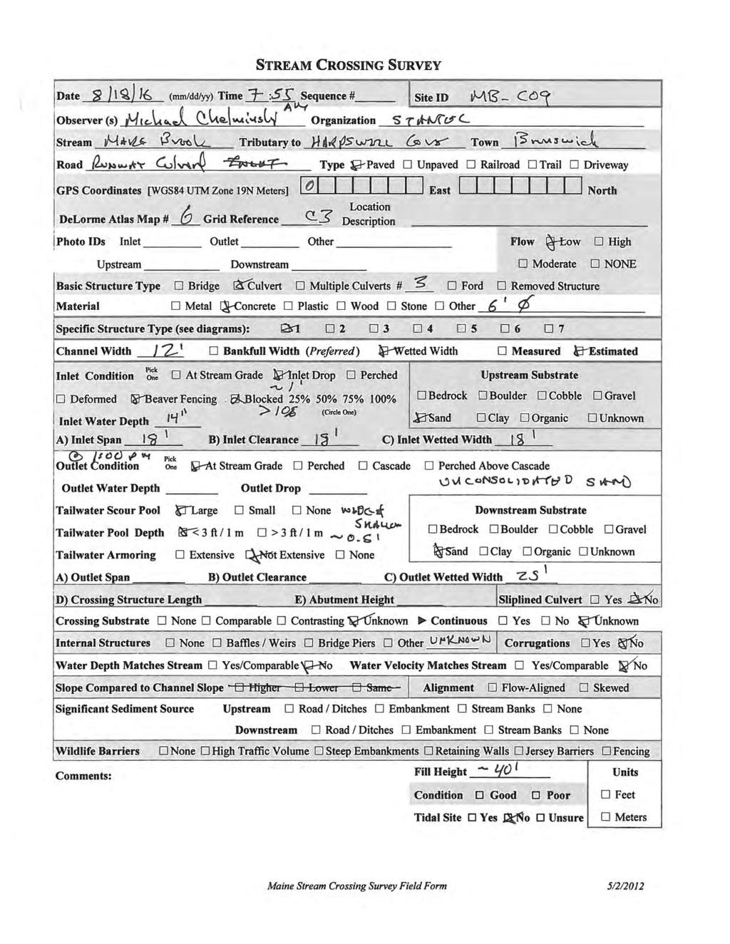
25 Preliminary Assessment of Upstream Fish Passage Runway Culvert (Feature ID MB_C09) The culvert that conveys Mare Brook under the Brunswick Executive Airport runway consists of three PCP culverts with diameters of 6 ft and lengths of approximately 3,500 ft. Water was observed flowing into and out of the three culvert barrels during the site visit. The culvert barrel outlet inverts were approximately 1 ft below the water surface of the tailwater plunge pool, but accumulated debris on security grates attached to the culvert outlets resulted in hydraulic drops of 0.5 to 1 ft at the culvert outlets during the site visit. Observed substrate in the plunge pool downstream from the culverts consisted of sand. No observations were made of conditions in the culvert barrels due to the long length of these culverts. Accumulated woody debris at the culvert inlet resulted in a hydraulic drop of approximately 1 ft during the site visit. Metal fence posts installed in front of the culvert inlets appear to contribute to accumulation of debris. Substrate upstream from the culvert inlets consists of sand Upstream Fish Passage Assessment Accumulated debris at the culvert outlets and inlets may result in hydraulic conditions that hinder or prevent upstream fish passage, and the long length of the culvert may result in a behavioral barrier to upstream fish passage. In addition, there may be physical barriers in the culvert barrels that were not identified as part of this study. The assigned rating for upstream fish passage at this stream crossing is therefore not passable Recommendations to Improve Upstream Fish Passage Removal of debris from the culvert outlets and inverts could eliminate potential physical (hydraulic) barriers to fish passage, but it was not determined whether there may be other physical barriers to upstream passage in the culvert, such as obstructions and areas of very shallow and/or higher-speed flow. In addition, behavioral factors associated with the long length of these culverts and associated persistent darkness may preclude upstream passage even if physical factors are addressed. A potential approach to restoring upstream fish passage in Mare Brook in the vicinity of the Brunswick Executive Airport runway is to realign the stream channel around the south side of the runway. This approach would be a significant undertaking, but is recommended for evaluation if it is determined that replacement of the existing culverts is necessary to maintain conveyance in Mare Brook. Additional study is therefore recommended at this site. 23


26 Preliminary Assessment of Upstream Fish Passage Photo 18: Outlet of Runway Culverts. Stantec. August Photo 19: Inlet of Runway Culverts. Stantec. August
27 Preliminary Assessment of Upstream Fish Passage Major Pope Avenue Stream Crossing (Feature ID MB_C10) The Major Pope Avenue stream crossing of Mare Brook consists of a CMP culvert with a diameter of 10 ft and a length of approximately 110 ft. Water was flowing through the culvert during the site visit. The culvert barrel outlet invert was perched approximately 1 ft above the water surface in the downstream plunge pool and was hydraulically perched by approximately 1.5 ft. Flow discharges onto a riprap apron downstream from the culvert outlet. The depth of the plunge pool was estimated to be more than 3 ft, and substrate in the plunge pool included sand, gravel, cobble, and boulder material. Deterioration and deformation of the culvert barrel was observed at the outlet. There is a metal security grate in the culvert approximately 15 ft upstream from the culvert outlet, and accumulated debris along the upstream side of the grate resulted in a hydraulic drop of approximately 1 ft. There is another security grate over the inlet to the culvert that is combined with a security fence along the downstream side of the overlying roadway to limit access to the Brunswick Executive Airport runway area. The estimated depth of water at the culvert inlet was approximately 1 ft. While some woody debris was accumulated on the debris gate, the debris did not appear to result in a hydraulic drop. Debris obscured the inlet invert of the culvert during the site visit, and it was therefore not determined whether the culvert inlet is perched. Substrate upstream from the culvert inlet consists of sand Upstream Fish Passage Assessment It is not expected that this culvert is upstream-passable due to the perched condition of the culvert outlet and debris on the debris gate upstream from the culvert outlet. The assigned rating for upstream fish passage at this stream crossing is therefore not passable Recommendations to Improve Upstream Fish Passage Providing conditions suitable for upstream fish passage by modifying the existing culvert or the downstream reach of stream channel (e.g., increasing tailwater elevation) does not appear to be practical or feasible due to the hydraulic gradient between the upstream and downstream ends (estimated to be approximately 2.5 ft) and accumulation of debris on the two security grates that are installed in this culvert. The recommended approach to improving upstream fish passage at the Major Pope Avenue stream crossing is to replace the existing culvert with a larger culvert that is designed to provide for upstream fish passage. 25


28 Preliminary Assessment of Upstream Fish Passage Photo 20: Outlet of Major Pope Avenue Culvert. Stantec. August Photo 21: Inlet of Major Pope Avenue Culvert. Stantec. August
29 Preliminary Assessment of Upstream Fish Passage Liberty Crossing Drive Stream Crossing (Feature ID MB_C11) The Liberty Crossing Drive stream crossing of Mare Brook consists of a rectangular CIP culvert with a height and width of 9 ft. The estimated length of both culverts is approximately 60 ft. This stream crossing is located in the tidally affected reach of Mare Brook, and water was observed flowing seaward ( downstream ) through the culvert during the site visit. The bottom of this culvert is flat in cross section and appears to have no slope in the streamwise direction. The depth of water during the site visit was approximately 0.5 ft at the inlet and outlet, but appeared to be falling with the ebb tide. There is a large plunge pool seaward from the culvert, and boulder-size riprap was observed in the plunge pool. The estimated depth of the plunge pool is 6 ft. The low-tide water surface elevation was not observed during the site visit for this study, but observations by Stantec during other project studies indicate that the downstream water surface elevation drops below the culvert invert at low tide. Monitoring is therefore recommended to determine if the downstream water surface elevation drops below the elevation of the culvert bottom. There are no pronounced features or accumulated sediment or debris on the bottom of the culvert. The inlet invert of the culvert was at the approximate elevation of the stream channel upstream from the culvert. Sand was the dominant substrate in the channel upstream from the culvert Upstream Fish Passage Assessment Observed conditions indicate that this culvert is upstream passable at higher tides during typical instream flows. The assigned rating for upstream fish passage at this stream crossing is therefore good. A rating of very good was not assigned due to uncertainty regarding the potential for upstream fish passage during low-tide conditions Recommendations to Improve Upstream Fish Passage Additional study is recommended at this location to evaluate effects of regular tidal conditions on upstream fish passage. The recommended evaluation is to install datalogging pressure transducers in Mare Brook upstream and downstream from this culvert to obtain information on tidal water surface elevations and present findings of this evaluation as they relate to upstream fish passage. 27
.")

30 Preliminary Assessment of Upstream Fish Passage Photo 22: Inlet of Liberty Crossing Drive Culvert (seaward flow is into the image). Stantec. August Photo 23: Outlet of Liberty Crossing Drive Culvert (seaward flow is from right to left). Stantec. August
31 Preliminary Assessment of Upstream Fish Passage 2.2 MERRICONEAG STREAM STUDY SITES This section presents study findings for the three study sites along Merriconeag Stream Beaver Pond Road Stream Crossing (Feature ID MS_C01) The Beaver Pond Road stream crossing of Mare Brook is at the upstream limit of the study reach of Merriconeag Stream. Beaver Pond Road is approximately 12 ft higher than the thalweg of the channel downstream from the roadway and approximately 6 ft higher than the channel thalweg upstream from the roadway. No outlet or inlet to a culvert was identified at this site. Dispersed flow was observed into rock riprap and accumulated sediment along the upstream side of the roadway embankment, and flow along the downstream side of the embankment was diffuse prior to discharging into a defined channel with a width of less than 3 ft and a depth of approximately 1 ft Upstream Fish Passage Assessment The diffuse flow into and out of the Beaver Pond Road roadway embankment precludes upstream fish passage at this site, and the assigned rating for upstream fish passage at this stream crossing is therefore not passable Recommendations to Improve Upstream Fish Passage Providing upstream fish passage at Beaver Pond Road would require installation of a larger culvert and restoration of the upstream reach of Merriconeag Stream. The need for restoration of the upstream reach of the brook is based on accumulation of sediment upstream from the road, which has an estimated depth of up to 6 ft based on the estimated heights of the roadway above the upstream and downstream channels of the brook. Additional study is therefore recommended at this site. 29
 and Roadway Embankment (background) on Downstream Side of")

32 Preliminary Assessment of Upstream Fish Passage Photo 24: Channel (foreground) and Roadway Embankment (background) on Downstream Side of Beaver Pond Drive. Stantec. August Photo 25: Merriconeag Stream Upstream from Beaver Pond Drive (flow is into rock on right side of image). Stantec. August
 Picnic Pond Dam is located on Merriconeag Stream downstream from Beaver Pond Road and upstream from Purinton Road.")
33 Preliminary Assessment of Upstream Fish Passage Picnic Pond Dam (Feature ID MS_D01) Picnic Pond Dam is located on Merriconeag Stream downstream from Beaver Pond Road and upstream from Purinton Road. The dam is located to the east of a former picnic area, and consists of an approximately 160-ft-long embankment with drop-structure inlet for discharging normal flows into the downstream reach of Merriconeag Stream and a grouted-stone overflow spillway. The estimated hydraulic and structural heights of the dam are 6 ft and 8 ft, respectively Upstream Fish Passage Assessment There are no provisions for upstream fish passage at Picnic Pond Dam, and the assigned rating for upstream fish passage is therefore not passable Recommendations to Improve Upstream Fish Passage Potential actions provide upstream fish passage at Picnic Pond Dam include installation of a fishpass or removal of the dam. Additional study is therefore recommended at this site. Photo 26: Picnic Pond Dam (flow is from left to right). Stantec. August
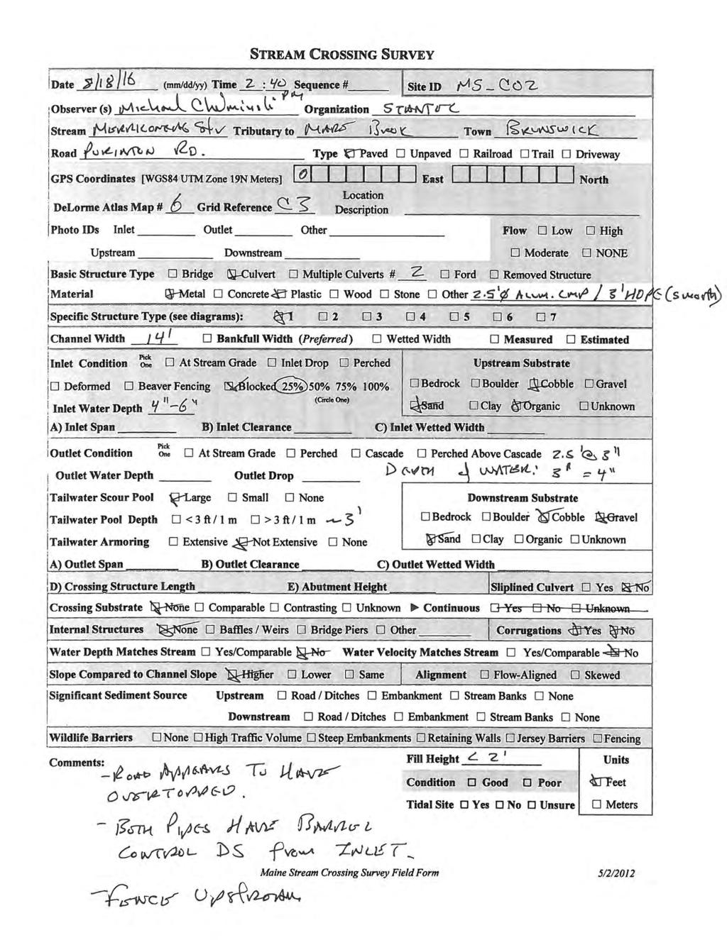
34 Preliminary Assessment of Upstream Fish Passage Purinton Road Stream Crossing (Feature ID MS_C02) The Purinton Road stream crossing of Merriconeag Stream consists of two adjacent culverts. The left culvert is a 2.5-ft-diameter CMP and the right culvert is a 3-ft-diameter CPP with a smoothbore. The estimated length of both culverts is approximately 40 ft, and water was flowing through both culverts during the site visit. The culvert outlet inverts in the right and left culverts were approximately 0.5 ft and 0.3 ft, respectively, below the water surface in the downstream plunge pool during the site visit. Substrates in the plunge pool include gravel and cobble material. Observations into the culvert barrels indicate that backwater conditions were present in the downstream ends of the culverts, but the pipe control was present in the upstream ends of the culverts downstream from the culvert inlets. The inlet inverts of both culverts were approximately 0.5 ft below the water surface during the site visit, and some woody debris was apparent at the culvert inlets. Substrate in the channel upstream from this stream crossing includes muck, sand, gravel, and cobble material. The channel upstream from the culverts is poorly defined and the stream flows around vegetated hummocks and through a security fence that parallels Purinton Road approximately 15 ft upstream from the upstream side of the roadway embankment Upstream Fish Passage Assessment The submerged condition of the culvert inlets and backwatered conditions in the downstream sections of these culverts may allow for some upstream fish passage during lower flows. However, pipe control in the upstream sections of these culverts may hinder or prevent upstream fish passage. The assigned rating for upstream fish passage at this stream crossing is therefore poor Recommendations to Improve Upstream Fish Passage The recommended action to improve upstream fish passage at the Purinton Road stream crossing is to install a single, larger culvert. 32


35 Preliminary Assessment of Upstream Fish Passage Photo 27: Outlets of Purinton Road Culvert. Stantec. August Photo 28: Inlets of Purinton Road Culvert. Stantec. August
36 Summary and Discussion 3.0 SUMMARY AND DISCUSSION This section summarizes information for the 13 culverts and two dams that are evaluated for upstream fish passage in Section SUMMARY Table 3 presents a summary of the assigned upstream fish passage ratings and recommendations for the 12 study sites on Mare Brook, and Table 4 presents similar information for the three study sites on Merriconeag Stream. Table 3: Summary of Findings at Mare Brook Sites Feature ID Feature Identifier Type Assigned Rating Recommendation MB_C01 Baribeau Drive Culvert Not Passable Replacement MB_C02 Barrow Street Culvert Good Replacement MB_C03 MacMillan Drive Culvert Good Replacement MB_C04 Maine Street Culvert Not Passable Replacement MB_C05 Meadowbrook Road Culvert Good Replacement MB_D01 Coffin Pond Dam Dam Not Passable Additional Study MB_C06 State Route 123 Culvert Not Passable Replacement MB_C07 Security Road Culvert Not Passable Replacement MB_C08 Samuel Adams Drive Culvert Good Monitor MB_C09 Runway Culvert Culvert Not Passable Additional Study MB_C10 Major Pope Ave. Culvert Not Passable Replacement MB_C11 Liberty Crossing Drive Culvert Good Monitor Table 4: Summary of Findings at Merriconeag Stream Sites Feature ID Feature Identifier Type Assigned Rating Recommendation MS_C01 Beaver Pond Road Culvert Not Passable Additional Study MS_D01 Picnic Pond Dam Dam Not Passable Additional Study MS_C02 Purinton Road Culvert Poor Replacement 34
37 References 3.2 DISCUSSION Six of the 11 evaluated stream crossings and Coffin Pond Dam on Mare Brook were rated as not passable for upstream passage of the target fish species and life stage (adult brook trout). The remaining 5 stream crossings on Mare Brook were rated as good for upstream passage. Based on these findings, it is concluded that the evaluated sites substantially limit upstream movement of that target species and life stage in Mare Brook. The evaluated stream crossings at Beaver Pond Road and Purinton Road on Merriconeag Stream were rated as not passable and poor, respectively, and upstream fish passage is not available at Picnic Pond Dam. Similar to the evaluated conditions on Mare Brook, it is concluded that the evaluated sites substantially limit upstream movement of that target species and life stage in Merriconeag Stream. Replacement of the existing culverts with culverts or bridges that are designed to provide for upstream passage appears to be practical at most of the study sites on Mare Brook and Merriconeag Stream, including those sites where upstream passage was rated as not passable, poor, and good. Replacement in-kind is not recommended at any of the evaluated sites except for the Samuel Adams Drive culvert. While upstream fish passage at the Samuel Adams Drive culvert was rated as good and not very good, the lower rating was assigned based on the potential for debris accumulation on the culvert inlet debris gate and can be addressed by regular maintenance. Additional study is recommended for evaluation of potential approaches to improving upstream fish passage at the Runway Culvert on Mare Brook. As described in Section , behavioral factors may prevent upstream fish passage even with suitable hydraulic conditions through this culvert. Additional study is also recommended for evaluation of potential approaches to improving upstream fish passage at the Beaver Pond Road stream crossing on Merriconeag Stream. The suggested focus of this study is whether the existing stream crossing is hydraulically adequate to convey high flows in Merriconeag Stream given that the existing culvert inlet is not visible and may be occluded by debris. Coffin Pond Dam on Mare Brook and Picnic Pond Dam on Merriconeag Stream are both barriers to upstream fish passage. Potential actions to improve upstream fish passage at these sites include installation of upstream fish passes and dam removal. Addition study is recommended at both dams. 4.0 REFERENCES Abbott, A Maine stream crossing survey manual. Gulf of Maine Coastal Program, U.S. Fish and Wildlife Service, Falmouth, Maine, USA. May. 35
38 Appendix A Survey Implementation Plan: Fish Passage Assessment at Mare Brook Culverts Appendix A SURVEY IMPLEMENTATION PLAN: FISH PASSAGE ASSESSMENT AT A.1
39 Survey Implementation Plan: Fish Passage Assessment at Mare Brook Culverts Fish Passage Assessment Component of Mare Brook Watershed Assessment and Community Engagement Project Prepared for: FB Environmental Associates 97A Exchange Street, Suite 305, Portland, ME Prepared by: Stantec Consulting Services Inc. 30 Park Drive Topsham, ME June 15, 2016
40 SURVEY IMPLEMENTATION PLAN: FISH PASSAGE ASSESSMENT AT Table of Contents 1.0 INTRODUCTION PROJECT AND TASK ORGANIZATION Stantec Roles and Responsibilities FB Environmental Roles and Responsibilities PRELIMINARY ASSESSMENT OF UPSTREAM FISH PASSAGE SURVEY PURPOSE SAFETY SURVEY EXTENT SITE ACCESS SURVEY AND REPORTING Schedule Survey Methods Reporting REFERENCES... 4 STREAM CROSSING SURVEY FORM... A.1 i
41 SURVEY IMPLEMENTATION PLAN: FISH PASSAGE ASSESSMENT AT 1.0 INTRODUCTION This Survey Implementation Plan (SIP) was prepared by Stantec Consulting Services Inc. (Stantec) as part of a preliminary fish passage assessment at culverts and other identified structures on Mare Brook in Brunswick, Maine. FB Environmental is contracted to the Town of Brunswick, Maine (Town), to perform the Project. Stantec is performing the preliminary fish passage assessment as a subcontractor to FB Environmental Associates (FB Environmental) as part of the Mare Brook Watershed Assessment and Community Engagement Project (Project). 1.1 PROJECT AND TASK ORGANIZATION This section presents information on project and task organization. Stantec is a subcontractor to FB Environmental; as such, Stantec will provide reports and information to FB Environmental and FB Environmental will coordinate with external entities Stantec Roles and Responsibilities Stantec will implement its internal review process in accordance with Stantec s Project Management Framework (PM Framework). The PM Framework is a component of Stantec s ISO 9001 Quality Management System. Michael Chelminski, P.E. of Stantec will serve as the Technical Lead for implementation of work described in this SIP. David Huntress, P.E. of Stantec will perform Stantec s internal Quality Review. Bryan Emerson of Stantec will perform Stantec s internal Independent Review. Stantec will document the internal review process and provide this documentation in deliverables to FB Environmental FB Environmental Roles and Responsibilities Stantec will provide deliverables to FB Environmental. FB Environmental will coordinate with external entities, including the Town and others. FB Environmental will identify the distribution list for materials prepared by Stantec and distribute the materials accordingly. 1
42 SURVEY IMPLEMENTATION PLAN: FISH PASSAGE ASSESSMENT AT 2.0 PRELIMINARY ASSESSMENT OF UPSTREAM FISH PASSAGE 2.1 SURVEY PURPOSE The purpose of this survey is to make visual observations and obtain limited measurements of features and conditions that may be used to develop a preliminary assessment of upstream fish passage at each stream crossing for adult brook trout (Salvelinus fontinalis) on the study reach of Mare Brook in Brunswick, Maine. 2.2 SAFETY Stantec will perform field surveys as part of this assessment in accordance with our Health and Safety Program. 2.3 SURVEY EXTENT The extent of this survey is the reach of Mare Brook from Baribeau Drive to tidewater and the reach of Merriconeag Stream from Beaver Pond Road to its confluence with Mare Brook. The survey will include identified instream features, such as the Coffin Pond Dam adjacent to Harpswell Road (State Route 123) and the dam on Merriconeag Stream upstream from Purinton Road. Survey work along Mare Brook between Baribeau Drive and Harpswell Road (State Route 123) will be performed from the roadway and apparent roadway easement. 2.4 SITE ACCESS FB Environmental will obtain permissions for access to other areas identified by Stantec as necessary to perform the survey, including access to the reach of Mare Brook and Merriconeag Stream in the former Brunswick Naval Air Station (BNAS). 2.5 SURVEY AND REPORTING Schedule Stantec will coordinate with FB Environmental for scheduling of the field surveys. The identified schedule is to perform the field surveys and submit draft deliverable prior to July 20, Survey Methods The preliminary assessment will be based on observed conditions at each stream crossing, such as perched culvert outlets, steep culverts, and very shallow water. Stream crossing survey forms will be prepared and representative photographs will be taken as part of the field assessment. 2
43 SURVEY IMPLEMENTATION PLAN: FISH PASSAGE ASSESSMENT AT The field survey will be performed in accordance with methods described in Abbot (2012), and a Stream Crossing Survey form from Abbott (2012) will be filled out for each evaluated stream crossing. A copy of the Stream Crossing Survey form is included in Appendix A. Digital photographs will be taken at each evaluated stream crossing as described in Abbott (2012). Coordinate data will be obtained using existing data sources (e.g., StreamStats, Google Earth) Reporting Stantec will prepare draft and final reports based on information obtained as part of the field surveys. The draft report will include brief narrative assessments, photographs, and field forms for each evaluated site and concept-level recommendations to improve upstream fish passage. The draft report will be provided to FB Environmental in editable format (i.e., Microsoft Word). The final report will be provided in Adobe PDF file format. Additional deliverables will include photographs of each site. 3
44 SURVEY IMPLEMENTATION PLAN: FISH PASSAGE ASSESSMENT AT 3.0 REFERENCES Abbott, A Maine stream crossing survey manual. Gulf of Maine Coastal Program, U.S. Fish and Wildlife Service, Falmouth, Maine, USA. May. 4

45 SURVEY IMPLEMENTATION PLAN: FISH PASSAGE ASSESSMENT AT Appendix A Stream Crossing Survey Form June 15, 2016 Appendix A STREAM CROSSING SURVEY FORM A.1
46 Appendix B Stream Crossing Survey Forms Appendix B STREAM CROSSING SURVEY FORMS B.1
47
48
49
50
51
52
53
54
55
56
57
58
59
60
61
Culvert Design for Low and High Gradient Streams in the Midwest. Dale Higgins, Hydrologist Chequamegon-Nicolet National Forest
 Culvert Design for Low and High Gradient Streams in the Midwest Dale Higgins, Hydrologist Chequamegon-Nicolet National Forest Overview Culvert Design Considerations Hydraulic Terms Culvert Impacts Low
CHAPTER 5 CULVERT DESIGN
 CHAPTER 5 CULVERT DESIGN HYDRAULICS OF CULVERTS There are two major types of culvert flow: 1) flow with inlet control, and 2) flow with outlet control. For each type, different factors and formulas are
Aquatic Organism Passage at Road-Stream Crossings CHUCK KEEPORTS FOREST HYDROLOGIST ALLEGHENY NATIONAL FOREST WARREN, PENNSYLVANIA
 Aquatic Organism Passage at Road-Stream Crossings CHUCK KEEPORTS FOREST HYDROLOGIST ALLEGHENY NATIONAL FOREST WARREN, PENNSYLVANIA TOPICS COVERED Aquatic Organism Passage (AOP) Benefits of AOP Crossings
Great Lakes Stream Crossing Inventory Instructions
 Great Lakes Stream Crossing Inventory Instructions This document is a guide to completing the Stream Crossing Data Sheet (2/28/11 version). Careful attention to this guidance will ensure consistent crossing
Culvert Design An Overview of the NYS Highway Design Manual Chapter 8
 Seventeenth Statewide Conference on Local Bridges Culvert Design An Overview of the NYS Highway Design Manual Chapter 8 Tuesday, October 25, 2011 Training Session: Culvert Design, Analysis - talk 2 Presented
DRAFT. Stonybrook Creek Watershed
 DRAFT Stonybrook Creek Watershed A Strategic Plan for Eliminating Barriers to Steelhead Migration June 4, 2010 Prepared by: PO Box 4477, Arcata, CA 95518 mlove@h2odesigns.com / (707) 476 8938 Prepared
HY-8 Version 7.2 Build Date January 17, Federal Highway Administration.
 HY-8 Version 7.2 Build Date January 17, 2012 Federal Highway Administration http://www.fhwa.dot.gov/engineering/hydraulics/software/hy8/index.cfm SIMPLE Simple to use Use for simple culverts and bridges
(Revised February,2005) CULVERTS, BRIDGES, AND FORDS
 CULVERTS, BRIDGES, AND FORDS") GUIDE TO STREAM CROSSINGS (Revised February,2005) CULVERTS, BRIDGES, AND FORDS Culverts, bridges, and fords are all methods used to cross-streams. Culverts are the most common stream crossing structure.
GUIDE TO STREAM CROSSINGS (Revised February,2005) CULVERTS, BRIDGES, AND FORDS Culverts, bridges, and fords are all methods used to cross-streams. Culverts are the most common stream crossing structure.
Big Spring Creek Habitat Enhancement and Fishery Management Plans
 Big Spring Creek Habitat Enhancement and Fishery Management Plans November 5, 2012 Big Spring Events and Activities Center Newville, PA Charlie McGarrell Regional Habitat Biologist Pennsylvania Fish and
SELBY CREEK SILVERADO TRAIL CULVERT FISH PASSAGE ASSESSMENT
 SELBY CREEK SILVERADO TRAIL CULVERT FISH PASSAGE ASSESSMENT NAPA COUNTY, CALIFORNIA PREPARED BY NAPA COUNTY RESOURCE CONSERVATION DISTRICT 1303 JEFFERSON ST. SUITE 500B NAPA, CALIFORNIA 94559 WWW.NAPARCD.ORG
APPENDIX J HYDROLOGY AND WATER QUALITY
 APPENDIX J HYDROLOGY AND WATER QUALITY J-1 Technical Report on Airport Drainage, Northern Sector Airport and Ordinance Creek Watershed / Preliminary Creek Constructed Natural Channel Culvert J-2 Preliminary
If you have comments on this or suggestions for other terms that should be added to this glossary, please send an to
 Tide Gates Glossary There is very little information available anywhere related to tide gates and flap gates. This is a glossary of terms that are associated with, or useful when discussing, tide gates.
FISH PASSAGE ALTERNATIVES ANALYSIS ON PENNYPACK CREEK AT VERREE ROAD DAM AND ROOSEVELT BOULEVARD DAM PHILADELPHIA, PENNSYLVANIA
 FISH PASSAGE ALTERNATIVES ANALYSIS ON PENNYPACK CREEK AT VERREE ROAD DAM AND ROOSEVELT BOULEVARD DAM PHILADELPHIA, PENNSYLVANIA Prepared for: One Parkway, 10 th Floor 1515 Arch Street Philadelphia, PA
APPENDIX C VEGETATED EMERGENCY SPILLWAY. VERSION 1.0 March 1, 2011
 APPENDIX C VEGETATED EMERGENCY SPILLWAY VERSION 1.0 March 1, 2011 [NOTE: Could use a better photo more clearly showing the emergency spillway in the context of the dam.] SECTION C-1: DESCRIPTION OF PRACTICE
UNDERWATER BRIDGE INSPECTION REPORT DISTRICT 8 - LAC QUI PARLE COUNTY
 UNDERWATER BRIDGE INSPECTION REPORT STRUCTURE NO. 6391 CSAH NO. 33 OVER THE MINNESOTA RIVER DISTRICT 8 - LAC QUI PARLE COUNTY PREPARED FOR THE MINNESOTA DEPARTMENT OF TRANSPORTATION BY COLLINS ENGINEERS,
JAP Additional Information Sheet
 JAP Additional Information Sheet Block 15: Purpose and Need The USACE purpose of the project is to provide a safe and reliable whitewater park for the recreational public in a city park, which will provide
Storm Damage Floating Culverts & Other Inlet Issues
 Storm Damage Floating Culverts & Other Inlet Issues Mark Bailey, PE - Hydraulic Manager, INDOT Dale Sedler, PE - Sr. Hydraulic Engineer, INDOT Road School 2016 What causes a culvert to float? 1. Accumulation
INFILTRATION PRACTICE MAINTENANCE INSPECTION FORM
 Facility Number: Date: Time: Subdivision Name: Watershed: Weather: Inspector(s): Date of Last Rainfall: Amount: Inches Streets: Mapbook Location: GPS Coordinates: Property Classification: Residential 9
APPENDIX A STRUCTURE DESCRIPTIONS AND RATING CURVES
 3 4 5 6 7 8 9 0 3 APPENDIX A STRUCTURE DESCRIPTIONS AND RATING CURVES Kissimmee River Vol December 005 Version Draft 4 3 4 5 6 7 8 9 0 3 4 5 6 7 8 9 0 3 4 5 6 7 8 9 30 3 3 33 34 35 36 37 38 39 40 4 4 43
OFFICE OF STRUCTURES MANUAL FOR HYDROLOGIC AND HYDRAULIC DESIGN CHAPTER 13 CULVERTS APRIL 2011
 OFFICE OF STRUCTURES MANUAL FOR HYDROLOGIC AND HYDRAULIC DESIGN CHAPTER 13 CULVERTS APRIL 2011 APRIL 2011 Chapter 13 Culverts Table of Contents Foreword.3 13.1 Introduction.. 4 13.2 Policy 6 13.3 Passage
STRUCTURAL STABILITY ASSESSMENT
 STRUCTURAL STABILITY ASSESSMENT CFR 257.73(d) Fly Ash Reservoir II Cardinal Plant Brilliant, Ohio October, 2016 Prepared for: Cardinal Operating Company Cardinal Plant Brilliant, Ohio Prepared by: Geotechnical
FINAL REPORT. Yonkers Creek Migration Barrier Removal Project Wonderstump Road Del Norte County. Submitted By:
 FINAL REPORT Yonkers Creek Migration Barrier Removal Project Wonderstump Road Del Norte County Submitted By: Del Norte County Community Development Department Yonkers Creek Migration Barrier Removal Project
Stream Crossings I: Engineering and Design Approaches to Provide Fish Passage at Culvert Slipline Projects in Connecticut
 University of Massachusetts - Amherst ScholarWorks@UMass Amherst International Conference on Engineering and Ecohydrology for Fish Passage International Conference on Engineering and Ecohydrology for Fish
UNDERWATER BRIDGE INSPECTION REPORT STRUCTURE NO CSAH 4 OVER THE BEAVER RIVER ST. LOUIS COUNTY
 UNDERWATER BRIDGE INSPECTION REPORT STRUCTURE NO. 7635 CSAH 4 OVER THE BEAVER RIVER ST. LOUIS COUNTY JUNE 18, 2012 PREPARED FOR THE MINNESOTA DEPARTMENT OF TRANSPORTATION BY COLLINS ENGINEERS, INC. JOB
Fish Passage Assessment of Private Stream Crossings on Lower Stonybrook Creek
 Fish Passage Assessment of Private Stream Crossings on Lower Stonybrook Creek Prepared by: Michael Love & Associates In cooperation with: Center for Ecosystem Management and Restoration Funded by: Coastal
UNDERWATER BRIDGE INSPECTION REPORT DISTRICT 8 - LAC QUI PARLE COUNTY
 UNDERWATER BRIDGE INSPECTION REPORT STRUCTURE NO. 6391 CSAH NO. 33 OVER THE MINNESOTA RIVER DISTRICT 8 - LAC QUI PARLE COUNTY OCTOBER 22, 2012 PREPARED FOR THE MINNESOTA DEPARTMENT OF TRANSPORTATION BY
Chadbourne Dam Repair and Fish Barrier
 Chadbourne Dam Repair and Fish Barrier Final Report for the Western Native Trout Initiative Prepared by: Carol Endicott Yellowstone Cutthroat Trout Conservation Biologist Montana Fish, Wildlife & Parks
BC Ministry of Forests. March Fish Stream Crossing Guidebook. Forest Practices Code of British Columbia.
 FRST 557 Lecture 7c Bridges and Culverts: Water Velocity and Discharge Lesson Background and Overview: The previous two lessons presented methods for estimating water volume flow at a particular site and
Creek Trash Assessment (CTA) Methodology (Demonstration: Mill Run Creek, Cheltenham, Pa.)
 Methodology (Demonstration: Mill Run Creek, Cheltenham, Pa.)") Creek Trash Assessment (CTA) Methodology (Demonstration: Mill Run Creek, Cheltenham, Pa.) Mill Run Creek emerges from a storm sewer in Philadelphia to an open creek in Cheltenham. The Creek downstream
Creek Trash Assessment (CTA) Methodology (Demonstration: Mill Run Creek, Cheltenham, Pa.) Mill Run Creek emerges from a storm sewer in Philadelphia to an open creek in Cheltenham. The Creek downstream
Interim Guidance Fish Presence Absence
 Interim Guidance Fish Presence Absence Source: Forest Practices Act Guidance for Division 635 of the forest practices act dealing with stream classification when no fish surveys have been done (referenced
UNDERWATER BRIDGE INSPECTION REPORT STRUCTURE NO CSAH 133 OVER A DITCH ST. LOUIS COUNTY
 UNDERWATER BRIDGE INSPECTION REPORT STRUCTURE NO. 7780 CSAH 133 OVER A DITCH ST. LOUIS COUNTY SEPTEMBER 27, 2012 PREPARED FOR THE MINNESOTA DEPARTMENT OF TRANSPORTATION BY COLLINS ENGINEERS, INC. JOB NO.
Technical Report Culvert A Hydraulic Analysis
 DATE: November 3, 2011 Technical Report Culvert A Hydraulic Analysis TO: FROM: RE: Jim Reiser, P.E. Project Manager Parsons Brinckerhoff, Inc. Kurt Killian, P.E., CFM Parsons Brinckerhoff, Inc. Design
Chapter 11. Culverts and Bridges Design Checklist for Culvert Design
 Yes No N/A Design Requirements I. GENERAL DESIGN GUIDELINES Chapter 11. Culverts and Bridges A. Culvert design is in accordance with the Culverts chapter of Volume 2 of the UDFCD Manual for additional
USING A LABYRINTH WEIR TO INCREASE HYDRAULIC CAPACITY. Dustin Mortensen, P.E. 1 Jake Eckersley, P.E. 1
 USING A LABYRINTH WEIR TO INCREASE HYDRAULIC CAPACITY Dustin Mortensen, P.E. 1 Jake Eckersley, P.E. 1 Plum Creek Floodwater Retarding Structure No. 6 is located in an area of Kyle, Texas, that is currently
Massachusetts Stream Crossing Case Studies
 Massachusetts Stream Crossing Case Studies Amy Singler Associate Director, River Restoration Program Carrie Banks River Continuity Coordinator Case Studies: Public Benefits: Movement of goods and people
Indiana LTAP Road Scholar Core Course #10 Culvert Drainage. Presented by Thomas T. Burke, Jr., PhD, PE Christopher B. Burke Engineering, Ltd.
 Indiana LTAP Road Scholar Core Course #10 Culvert Drainage Presented by Thomas T. Burke, Jr., PhD, PE Christopher B. Burke Engineering, Ltd. Objectives Review culvert shapes, end sections, and materials
Feasibility Study for Restoration of Titlow Lagoon Fish Passage. South Puget Sound Salmon Enhancement Group
 Feasibility Study for Restoration of Titlow Lagoon Fish Passage South Puget Sound Salmon Enhancement Group January 2010 Feasibility Study for Restoration of Titlow Lagoon Fish Passage Prepared for South
CHAPTER 4 SPALDING COUNTY, GEORGIA 4.0 CULVERT DESIGN
 SPALDING COUNTY, GEORGIA CHAPTER 4 4.0 CULVERT DESIGN... 4-1 4.1 INTRODUCTION... 4-1 4.2 SYMBOLS AND DEFINITIONS... 4-1 4.3 ENGINEERING DESIGN CRITERIA... 4-2 4.3.1 FREQUENCY FLOOD... 4-2 4.3.2 VELOCITY
CALIFORNIA SALMONID STREAM HABITAT RESTORATION MANUAL APPENDIX IX-A CULVERT CRITERIA FOR FISH PASSAGE INTRODUCTION
 APPENDIX IX-A STATE OF CALIFORNIA RESOURCES AGENCY DEPARTMENT OF FISH AND GAME CULVERT CRITERIA FOR FISH PASSAGE For habitat protection, ecological connectivity should be a goal of stream-road crossing
Presented by Fred Halterman, URS Jennie Agerton, URS
 Presented by Fred Halterman, URS Jennie Agerton, URS What is Eco Friendly Culvert Design? Culvert design that: Maintains connectivity for aquatic organism migration Maintains connectivity for gene flow
TECHNICAL MEMORANDUM 002 EMORANNO. 001
 TECHNICAL MEMORANDUM 002 EMORANNO. 001 To: Jack Synder, P.E. EES Consulting From: Mort McMillen, P.E. Paul Larson, SE Date: October 13, 2010 Project: Cc: Taylor Bowen Subject: Technical Memorandum (TM)
Simulating Streams Through Culverts in Mat-Su, Alaska
 Simulating Streams Through Culverts in Mat-Su, Alaska Project Managers Bill Rice, P.E., USFWS Hydrologist Mary Price, USFWS Fishery Biologist The Team Approach US Fish and Wildlife Service Bill Rice, P.E.,
General Information for Culvert Design
 Design Manual Chapter 2 - Stormwater 2E - Culvert Design 2E-1 General Information for Culvert Design A. Introduction A culvert is a conduit under an embankment that transports stormwater from one side
Five Counties Salmonid Conservation Program - Fish Passage Design Workshop. February 2013
 Program - Aquatic Organisms and Stream Crossings Ecological Connectivity A watershed is a network of channels that drain a common boundary. Channel characteristics formed by interaction of precipitation,
UNDERWATER INSPECTION REPORT DOUBLE CORRUGATED METAL PIPE CULVERT HAWTHORN ROAD OVER RICE CREEK (PELKEY LAKE) MORRISON COUNTY
 MORRISON COUNTY") UNDERWATER INSPECTION REPORT DOUBLE CORRUGATED METAL PIPE CULVERT HAWTHORN ROAD OVER RICE CREEK (PELKEY LAKE) MORRISON COUNTY OCTOBER 25, 2012 PREPARED FOR MORRISON COUNTY PUBLIC WORKS BY COLLINS ENGINEERS,
UNDERWATER INSPECTION REPORT DOUBLE CORRUGATED METAL PIPE CULVERT HAWTHORN ROAD OVER RICE CREEK (PELKEY LAKE) MORRISON COUNTY OCTOBER 25, 2012 PREPARED FOR MORRISON COUNTY PUBLIC WORKS BY COLLINS ENGINEERS,
Annex E Bridge Pier Protection Plan
 Annex E Bridge Pier Protection Plan Table E1 Bridge Types and Locations Table E2 Flow Conditions For River Sections Figure E1 Bridge Abutment Protection Figure E2 Bridge Pier Protection Figure E3 Central
Project Report for Marsh Creek and Albion River Instream Fish Barrier Removal Flynn Creek Road, CR 135, M.P. 8.1 and 8.3
 Project Report for Marsh Creek and Albion River Instream Fish Barrier Removal Flynn Creek Road, CR 135, M.P. 8.1 and 8.3 Project Title: Marsh Creek and Albion River Instream Fish Barrier Removal, Flynn
Identifying and Executing Stream Projects Kristin Thomas, Aquatic Ecologist MITU
 Identifying and Executing Stream Projects Kristin Thomas, Aquatic Ecologist MITU Introduction 1. Methods for Identifying Projects 2. Methods in Action 3. The Partnership Paradigm 2 River Stewards Program
Fish Passage Culvert Assessment for Cahilty Creek Watershed FIA Project #
 Fish Passage Culvert Assessment for Cahilty Creek Watershed FIA Project # 4602004 Prepared for Weyerhaeuser Company Ltd. Jason Ladyman R.P.F. 1550 Mission Flats Road PO Box 40 Kamloops BC V2C 5K3 Prepared
Fish Passage at Road Crossings Assessment Boise National Forest FY 2004
 Culvert Inventory Summary 2004 - Boise National Forest Fish Passage at Road Crossings Assessment Boise National Forest FY 2004 Feather River at Road #135 Crossing By Michael S. Kellett, Fishery Biologist
Packwood Hydroelectric Project Barrier Analysis December 12, 2006
 Packwood Hydroelectric Project Barrier Analysis December 12, 2006 Study Area Natural barriers to upstream fish passage on Lake Creek at RM 1.03 and RM 1.95 Snyder Creek culvert under the Project tailrace
Fish Migration Barrier Severity and Steelhead Habitat Quality in the Malibu Creek Watershed
 Fish Migration Barrier Severity and Steelhead Habitat Quality in the Malibu Creek Watershed Produced for California State Coastal Conservancy and California Department of Parks and Recreation By: Heal
South Fork Chehalis Watershed Culvert Assessment
 South Fork Chehalis Watershed Culvert Assessment Water Resource Inventory Area 23 Lewis County Conservation District Final Report By: Kelly Verd and Nikki Wilson March 2003 Funded by: The Washington State
Chinook Salmon Spawning Study Russian River Fall 2005
 Chinook Salmon Spawning Study Russian River Fall 2005 Sonoma County Water Agency 2150 West College Avenue Santa Rosa, California 95401 Prepared by David Cook - Senior Environmental Specialist March 27,
UNDERWATER BRIDGE INSPECTION REPORT DISTRICT 1 PINE COUNTY
 UNDERWATER BRIDGE INSPECTION REPORT STRUCTURE NO. 58551 CSAH NO. 41 OVER THE KETTLE RIVER DISTRICT 1 PINE COUNTY JULY 28, 2012 PREPARED FOR THE MINNESOTA DEPARTMENT OF TRANSPORTATION BY COLLINS ENGINEERS,
Earthen Embankments. turning into larger, more costly repairs. The following. The State Dam Safety Program has inspection
 TOPIC: COMMON PROBLEMS FOR SMALL DAMS WITH CONCRETE CHANNEL SPILLWAYS The State Dam Safety Program has inspection requirements for state regulated dams. A dam, like any man-made structure, will change
Joe Rathbun Michigan DEQ Water Resources Division Nonpoint Source Unit * Thanks to The Nature Conservancy
 Joe Rathbun Michigan DEQ Water Resources Division Nonpoint Source Unit rathbunj@mi.gov * Thanks to The Nature Conservancy Road-stream intersections = 67,511 Culverts = 60,700 Bridges = 6,811 Perched Piping
UNDERWATER BRIDGE INSPECTION REPORT METRO DISTRICT - ANOKA COUNTY
 UNDERWATER BRIDGE INSPECTION REPORT STRUCTURE NO. 02545 CR NO. 116 OVER THE RUM RIVER METRO DISTRICT - ANOKA COUNTY SEPTEMBER 9, 2012 PREPARED FOR THE MINNESOTA DEPARTMENT OF TRANSPORTATION BY COLLINS
UNDERWATER BRIDGE INSPECTION REPORT STRUCTURE NO CSAH NO. 7 OVER THE SNAKE RIVER DISTRICT 1 - PINE COUNTY
 UNDERWATER BRIDGE INSPECTION REPORT STRUCTURE NO. 58506 CSAH NO. 7 OVER THE SNAKE RIVER DISTRICT 1 - PINE COUNTY PREPARED FOR THE MINNESOTA DEPARTMENT OF TRANSPORTATION BY COLLINS ENGINEERS, INC. JOB NO.
Final Bull Trout Redd Monitoring Report for the Wallowa Falls Hydroelectric Project
 Final for the Wallowa Falls Hydroelectric Project East Fork Wallowa River barrier to upstream fish migration, photo courtesy of Kendrick Moholt (FERC No. P-308) December 18, 2017 Prepared by: Jeremiah
Assessment of Baseline Geomorphic Features at. Proposed Stream Crossings On The Proposed County Road 595. Marquette County, Michigan
 Assessment of Baseline Geomorphic Features at Proposed Stream Crossings On The Proposed County Road 595 Marquette County, Michigan Prepared for: Kennecott Eagle Minerals Company Marquette, Michigan Prepared
Hydraulic Modeling of Stream Enhancement Methods
 Hydraulic Modeling of Stream Enhancement Methods Matthew J. Curry John J. Levitsky Abstract Development within watersheds increases the amounts of runoff causing stream erosion and degradation of stream
Newaukum Watershed Culvert Assessment
 Newaukum Watershed Culvert Assessment Water Resource Inventory Area 23 Lewis County Conservation District Final Report By: Kelly Verd and Nikki Wilson July 2002 Funded by: Chehalis Fisheries Restoration
Fish Friendly Crossings- Examples from Nash Stream
 Fish Friendly Crossings- Examples from Nash Stream Maggie Machinist- North Regional Forester, Division of Forests and Lands. Nash Stream Nash Stream Forest is 40,000 acres, owned and managed by NH Division
ADDENDA B Hydrologic and Hydraulic (H&H) Study Guidance 2019
 Study Guidance 2019") 09/25/2018 DRAFT FEMA Region I PA H&H Study ADDENDA B Hydrologic and Hydraulic (H&H) Study Guidance 2019 Region I Federal Emergency Management Agency (FEMA) Public Assistance Hydrologic and Hydraulic (H&H)
09/25/2018 DRAFT FEMA Region I PA H&H Study ADDENDA B Hydrologic and Hydraulic (H&H) Study Guidance 2019 Region I Federal Emergency Management Agency (FEMA) Public Assistance Hydrologic and Hydraulic (H&H)
HEC 26 Aquatic Organism Passage Design Manual Evolution & Application
 HEC 26 Aquatic Organism Passage Design Manual Evolution & Application Sven Leon, P.E., Hydraulics Engineer Federal Highway Administration 2015 Alaska Fish Passage Meeting October 13 14, 2015 VTRC, Juneau,
Sediment Basin 7E-12. Design Manual Chapter 7 - Erosion and Sediment Control 7E - Design Information for ESC Measures BENEFITS.
 7E-12 Design Manual Chapter 7 - Erosion and Sediment Control 7E - Design Information for ESC Measures Sediment Basin BENEFITS Flow Control Erosion Control Sediment Control Runoff Reduction Flow Diversion
Suitable Applications Check dams may be appropriate in the following situations: To promote sedimentation behind the dam.
 Categories EC Erosion Control SE Sediment Control TC Tracking Control WE Wind Erosion Control Non-Stormwater NS Management Control Waste Management and WM Materials Pollution Control Legend: Primary Category
APPENDIX B HYDRAULIC DESIGN DATA FOR CULVERTS
 TM 5-820-4/AFM 88-5, Chap 4 APPENDIX B HYDRAULIC DESIGN DATA FOR CULVERTS B-1. General. a. This appendix presents diagrams, charts, coefficients and related information useful in design of culverts. The
Applying Engineering Solutions to the Science of Protection and Enhancement of Aquatic Environments. Bill Holman, P.E. Stanley Consultants
 Applying Engineering Solutions to the Science of Protection and Enhancement of Aquatic Environments Bill Holman, P.E. Stanley Consultants Project Development PHASE STAGE TASKS PURPOSE I II III Investigation
Gales Creek Fish Passage Assessment and Prioritization
 Gales Creek Fish Passage Assessment and Prioritization Washington County, Oregon Authors: Stephen Cruise, Environmental Resource Specialist Janet Oatney, Sr. Environmental Resource Specialist Washington
Merrimack River Watershed MERRIMACK RIVER WATERSHED
 MERRIMACK RIVER WATERSHED 96 Merrimack River Watershed Merrimack River Newburyport, Amesbury, Merrimack, Haverhill, Groveland, Methuen, Lawrence, N. Andover, Andover, Dracut, Tewksbury, Lowell, Chelmsford,
STREAM SURVEY File form No..
 scanned for KRIS THE RESOURCES AGENCY OF CALIFORNIA California Department of Fish and Game STREAM SURVEY File form No.. Date: September 4, 1969. NAME: North Fork Schooner Gulch Creek COUNTY: Mendocino.
Vermont. Vermont Fish & Wildlife Department 1 National Life Drive Montpelier, VT
 Vermont Stream Crossing Vermont Fish & Wildlife Department 1 National Life Drive Montpelier, VT 05620-3702 802-828-1000 www.vtfishandwildlife.com Handbook Introduction Vermonters have always strongly connected
Washington State Fish Passage Barrier Removal Projects. Casey Kramer, PE WSDOT State Hydraulics Engineer
 Washington State Fish Passage Barrier Removal Projects Casey Kramer, PE WSDOT State Hydraulics Engineer 2014 National Hydraulic Engineering Conference Iowa City, IA August 20 th, 2014 WSDOT Fish Passage
Culvert Design Basics
 PDHonline Course C287 (4 PDH) Culvert Design Basics Instructor: George E. Thomas, PE 2012 PDH Online PDH Center 5272 Meadow Estates Drive Fairfax, VA 22030-6658 Phone & Fax: 703-988-0088 www.pdhonline.org
Applying Engineering Solutions to the Science of Invasive Aquatic Species Control Asian Carp and Sea Lamprey. Bill Holman, P.E. Stanley Consultants
 Applying Engineering Solutions to the Science of Invasive Aquatic Species Control Asian Carp and Sea Lamprey Bill Holman, P.E. Stanley Consultants Sea Lamprey: Great Lakes Invader Lake Superior Sea Lamprey
Mr. Michael Malone CPS Energy 145 Navarro Street, Mail Drop San Antonio, Texas Project No
 October 17, 2016 Mr. Michael Malone CPS Energy 145 Navarro Street, Mail Drop 100406 San Antonio, Texas 78296 Project No. 0352436 Subject: Compilation of Construction History Calaveras Power Station San
UNDERWATER BRIDGE INSPECTION REPORT STRUCTURE NO OVER THE STRAIGHT RIVER DISTRICT 6 - RICE COUNTY
 UNDERWATER BRIDGE INSPECTION REPORT STRUCTURE NO. 66513 14 th STREET (MSAS NO. 103) OVER THE STRAIGHT RIVER DISTRICT 6 - RICE COUNTY PREPARED FOR THE MINNESOTA DEPARTMENT OF TRANSPORTATION BY COLLINS ENGINEERS,
UNDERWATER BRIDGE INSPECTION REPORT STRUCTURE NO CSAH NO. 101 OVER THE MINNESOTA RIVER DISTRICT 8 - REDWOOD COUNTY
 UNDERWATER BRIDGE INSPECTION REPORT STRUCTURE NO. 7149 CSAH NO. 101 OVER THE MINNESOTA RIVER DISTRICT 8 - REDWOOD COUNTY PREPARED FOR THE MINNESOTA DEPARTMENT OF TRANSPORTATION BY COLLINS ENGINEERS, INC.
STUDY PERFORMANCE REPORT
 STUDY PERFORMANCE REPORT State: Michigan Project No.: F-80-R-4 Study No.: 702 Title: Effects of sediment traps on Michigan river channels Period Covered: October 1, 2002 to September 30, 2003 Study Objectives:
SUMMARY OF MOVEMENT AND HABITAT USED BY TAGGED BROOK TROUT IN THE MAIN BRANCH AND NORTH BRANCH AU SABLE RIVER DURING SUMMER Data Submitted to:
 SUMMARY OF MOVEMENT AND HABITAT USED BY TAGGED BROOK TROUT IN THE MAIN BRANCH AND NORTH BRANCH AU SABLE RIVER DURING SUMMER 2014 Data Submitted to: Anglers of the Au Sable Submitted by: Dr. Mark R. Luttenton
Lecture 10 : Sewer Appurtenances
 1 P age Module 8 : Sewer Appurtenances Lecture 10 : Sewer Appurtenances 2 P age The structures, which are constructed at suitable intervals along the sewerage system to help its efficient operation and
January Submitted by: 2200 Commonwealth Blvd, Suite 300 Ann Arbor, MI Ph: Fax:
 BOARDMAN RIVER FEASIBILITY STUDY A Report on the Boardman River Fisheries Habitat Survey & Data Collection January 2009 Submitted by: 2200 Commonwealth Blvd, Suite 300 Ann Arbor, MI 48105 Ph: 734-769-3004
Conclusions. Sincerely, Michael Callahan, Owner Beaver Solutions
 Conclusions The extensive beaver damming activity in the Mendenhall Glacier Recreation Area has resulted in negative impacts on many trails in this area. This has resulted in countless hours of labor by
Little Traverse Bay Watershed Road/Stream Crossing Inventory
 Little Traverse Bay Watershed Road/Stream Crossing Inventory Completed by Tip of the Mitt Watershed Council with support from: Petoskey-Harbor Springs Area Community Foundation s Little Traverse Bay Protection
TOP:001.3 U.S. Fish and Wildlife Service TECHNICAL OPERATING PROCEDURE
 TOP:001.3 March 12, 2015 U.S. Fish and Wildlife Service Marquette Biological Station 3090 Wright Street Marquette, Michigan 49855 U.S.A. and U.S. Fish and Wildlife Service Ludington Biological Station
Assessing Ecosystem Impacts from Road Stream Crossings through Community Involvement
 Assessing Ecosystem Impacts from Road Stream Crossings through Community Involvement Background Why is the NH Fish and Game Department interested in culverts? Block fish migration Reduce opportunities
Rehabilitation of Grimes Creek, a Stream Impacted in the Past by Bucket-lined Dredge Gold Mining, Boise River Drainage, July 2008 to August 2011.
 Rehabilitation of Grimes Creek, a Stream Impacted in the Past by Bucket-lined Dredge Gold Mining, Boise River Drainage, July 2008 to August 2011. Pam Harrington TU,1020 W. Main Street Suite 440, Boise,
The Basics of Culvert and Inlet Design
 PDHonline Course C619 (8 PDH) The Basics of Culvert and Inlet Design Jerry D. Morrow, PE 2013 PDH Online PDH Center 5272 Meadow Estates Drive Fairfax, VA 22030 6658 Phone & Fax: 703 988 0088 www.pdhonline.org
Estuarine Shoreline Stabilization
 Estuarine Shoreline Stabilization Property Owner s Guide to Determining the Most Appropriate Stabilization Method Estuarine shorelines are dynamic features that experience continued erosion. Land is lost
Stevens Creek Corridor
 O F F I C E O F T H E D I R E C T O R O F P U B L I C W O R K S Stevens Creek Corridor Creek Restoration Project Volume Three Project Update: Creek Photos, Before & After BY GAIL SEEDS - PROJECT MANAGER,
Outlet Structures T-12
 Description This section provides guidance and details for outlet structures for use primarily with BMPs utilizing sedimentation, (i.e., extended detention basins (EDBs), retention ponds, and constructed
Minnesota Department of Natural Resources Division of Fish and Wildlife Section of Fisheries. Stream Survey Report. Luxemburg Creek.
 Minnesota F-29-R(P)-24 Area 315 Study 3 March 2016 Minnesota Department of Natural Resources Division of Fish and Wildlife Section of Fisheries Stream Survey Report Luxemburg Creek 2015 Mark Pelham Sauk
Creation of Fish and Wildlife Habitat on the Closed Salmon Harbour Mine in Minto, NB
 Creation of Fish and Wildlife Habitat on the Closed Salmon Harbour Mine in Minto, NB M. Coleman 1, R. Rutherford 2, RA Currie 3 1 NB Power 2 Thaumas Environmental Consultants Ltd 3 RA Currie Ltd. Location
Pre-Application Document Kaweah Project (FERC Project No. 298)
") TABLE OF CONTENTS Page 3.12 Aesthetic Resources... 3.12-1 3.12.1 Information Sources... 3.12-1 3.12.2 Setting... 3.12-1 3.12.3 Project Facilities... 3.12-2 3.12.4 Previous Visual Resources Assessment...
TABLE OF CONTENTS Page 3.12 Aesthetic Resources... 3.12-1 3.12.1 Information Sources... 3.12-1 3.12.2 Setting... 3.12-1 3.12.3 Project Facilities... 3.12-2 3.12.4 Previous Visual Resources Assessment...
FISH PASSAGE IMPROVEMENT in California s Watersheds. Assessments & Recommendations by the Fish Passage Forum
 FISH PASSAGE IMPROVEMENT in California s Watersheds Assessments & Recommendations by the Fish Passage Forum FISH PASSAGE IMPROVEMENT in California s Watersheds The mission of the Fish Passage Forum is
COA-F17-F-1343 YEAR END REPORT
 DAVE MARSHALL SALMON RESERVE RESTORATION, MAINTENANCE, AND UPGRADES YEAR END REPORT Prepared for: Fish and Wildlife Compensation Program Prepared by: Edith Tobe, RPBio, Executive Director Box 1791, Squamish,
Green CCR Surface Impoundment
 Green CCR Surface Impoundment Disposal of Coal Combustion Residuals (CCR) from Electric Utilities Final Rule CCR Impoundment 2017 Annual Inspection Report January 11, 2018 Prepared By: Project ID: 170138A
HISTORY OF CONSTRUCTION
 HISTORY OF CONSTRUCTION CFR 257.73(c)(1) West Boiler Slag Pond Clifty Creek Plant Madison, Indiana October, 2016 Prepared for: Indiana Kentucky Electric Corporation Prepared by: American Electric Power