THE RIVER LUNE. fact file NRA. National Rivers Authority North West Region
|
|
|
- Imogen McKenzie
- 6 years ago
- Views:
Transcription

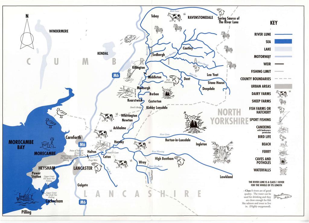
1 THE RIVER LUNE fact file NRA National Rivers Authority North West Region

2 THE RIVER LUNE The River Lune rises high on Ravenstonedale Common in Cumbria at an altitude of 540 metres and flows westward from Newbiggin-on-Lune before turning south at Tebay. It finally enters the Irish Sea, south of Lancaster, some 105 kilometres from its source. It is one of the largest fivers in the north west of England dtaining a catchment area of 1,223 square kilometres. A TOURIST ATTRACTION The area caters for a large number of tourists attracted by the small, picturesque villages and bustling market towns. Walking,, camping and potholing are popular pastimes in the limestone areas of Ingleborough and the Yorkshire Dales National Park. Waterskiing, camping, canoeing, birdwatching and angling also attract enthusiasts to the area. The lower reaches of the Lune have important recreational interests with adjacent footpaths, a cycleway and numerous picnic areas and viewpoints. PROTECTING WATER QUALITY Although the Lune's water is of the highest quality, it is still under constant threat from pollution. NRA Pollution Control Officers work to prevent pollution from farms, industry, and Waste Water Treatment Works. Agricultural effluents pose a particular threat to the Lune. For example, silage liquor (the liquid produced when farmers compress cut grass for winter feed) is around 300 times more polluting than raw sewage. Cattle slurry and milk are also highly polluting and pesticides from sheep dipping cause pollution at low concentrations. Some farms in the Lune catchment stand on a permeable limestone bed. If silage liquor escapes into the rock, it can flow through the limestone polluting underground streams and springs several kilometres downstream from the source. "Raskins View ", Kirby Lonsdale. PURE WATERS The Lune is one of the best salmon rivers in the country and is a class 1 river (good/excellent water quality) for the whole of its length. There are, however, some polluted tributaries in the urban areas. The catchment provides a diverse supply of water, for agricultural use to the north and industrial use in the lower reaches at Caton and Lancaster, due to its consistently high quality. The Lune's main use is as an important source of drinking water supplying parts of Lancaster. It also supports supplies to the Fylde Coast and the Greater Manchester conurbation via the transfer of water from the river at Halton to the River Wyre, where abstraction takes place. Water from the Estuary of Heysham Lake is abstracted for cooling purposes at Heysham Power Station. Nearly all abstractions need to be licensed. The licence says how much water can be taken and how often. It may not be granted at all if the taking of water would harm the environment or adversley affect other water users. The NRA ensures that the holders of water abstraction licences comply with the conditions of their licences. NRA staff work closely with farmers in the area to identify practical solutions to environmental problems. The NRA's aim is to prevent pollution. To this end, Pollution Control Officers working in rural areas have been trained in the many aspects of farm management and are aware of the demands placed on the fatmer's time and resources. The prosecution of farmers by the NRA following a pollution incident is a last resort. The same is true for industry and Pollution Control staff aim to prevent, rather than cure, pollution. One major role of the NRA is issuing "consents" - permission to discharge effluent within certain limits imposed by the NRA. Such limits are imposed on industrial discharges and sewage works alike. NRA staff constantly monitor discharges and can review the conditions of each consent every two years. If the consent limits are exceeded, the NRA can prosecute the offender. There are nearly 40 consented outfalls from Waste.Water Treatment Works (WWW). These include major discharges such as Lancaster WWTW and small rural systems serving individual villages. Most industrial wastes in the area drain to sewers for treatment, at WWTWs but 19 premises currently hold consents to discharge directly to the river. These include five separate fish farms/ hatcheries. The NRA can also prosecute for one-off spillages or any discharges without consent. (Frontpage photograph: the Lune at Devil's Bridge, Kirkby Lonsdale).

3 RAINFALL & RIVER FLOWS The Lune catchment is in a generally wet area of the country with high rainfall leading to a wide range of river flows. Annual rainfall varies from 2,160 mm at Borrowdale in the upper part of the river's catchment, to 960 mm in the estuary. The NRA's river flow measuring station at Caton shows an average annual flow of 30 cubic metres per second. The lowest flow on record occurred during the drought of 1976 when a reading of just 1.2 cubic metres per second was recorded. The highest flow was recorded during March 1968, of 900 cubic metres per second! BEATING THE FLOODS The NRA maintains 3.3 kilometres ofttidal defence embankment along the Lune estuary Ao protect low-lying inland areas. t Sea defence embankments built from Sunderland Point to Overton on the North side and Pilling to Cockerham south of the estuary also protect inland areas from flooding by the sea. (Total length 23.2 Kms). Maintenance works are constantly carried out by the NRA's Flood Defence staff in the never ending battle against floods. Control of riverbank vegetation and the removal of debris and silt deposits-(from the river bed and banks help to prevent localised flooding during high river flows. The NRA also operates a sophisticated round-the-clock Flood Warning Service which monitors weather systems and gives warnings of tidal and river flooding to the Police. The Police, in turn, warn Local Authorities and the public of imminent flooding so that preparations, such as sandbagging and safe storage of valuables, can be carried out well in advance. PLENTIFUL FISHERIES The Lune is noted fot its salmon and sea trout runs although it also supports fisheries for brown trout throughout its length and for a variety of coarse fish in its lower reaches. Skerton Weir. FLOODING The Lune is tidal to above the weir at Skerton. Only the coincidence of very high tides and fresh water flows can cause flooding by tidal waters. Incidentally, this can cause the intrusion of saline water into otherwise freshwater reaches. The lower and middle reaches of the valley bottom are prone to flooding during winter months. However, these floods rise and fall quickly and the land affected is agricultural pastureland. The town of Lancaster can also be at risk from some flooding, when high tides coincide with strong onshore winds. The river is almost unique in the north west of England in that it supports significant rod and line and commercial fisheries. The commercial fishery for salmon and sea trout involves the use of drift nets, a seine net and haaf nets. Haaf net fishing is unique to the north west and dates back to Viking times. There is also a small commercial fishery for eels in tidal Haaf net and freshwaters. fishing. Skerton Weir, whilst overtopped by the larger spring tides, is the effective tidal limit of the Lune. The Weir contains one of the largest fish passes in Europe. The worst flood in living memory was in August The rainfall on that occasion was of such intensity diat it was classified as "extremely rare" by the Meteorological Office and was centred over rhe Forest of Bowland. The worst affected tributaries of the Lune were the River Roeburn, Hindburn, Claughton Beck and Farleton Beck. The flood waters, charged with vast quantities of tree wreckage, debris, boulders and gravel, caused extensive damage to property, roads, weirs, public services, vehicles, livestock and farmland. The fish pass at Forge Weir.
4

5 The Lune Estuary has been designated as a "Site of Special Scientific Interest" (SSSI) under the Wildlife and Countryside Act. As part of Morecambe Bay, the estuary forms a major link in the chain of estuaries along the west coast of Britain used by birds on migration between the breeding grounds in the far north and the wintering grounds further south. A HAVEN FOR BIRDS... Forge Weir. The NRA operates two electronic fish counters on the river which provide information on the populations of migratory fish (salmon and sea trout) and data on the effects of river flow on fish movement. This information is particularly useful to the NRA in assessing the impact of abstractions of water on fish populations. A large part of the estuary between Knott End and Cockersands Point is covered by the Wyre-Lune Sanctuary which provides a protected roost for wintering pink-footed geese. Some of the saltmarshes are of interest for their breeding bird populations and collectively support a variety of plant communities and a number of uncommon plant species. The mud-flats are exposed for considerable periods between tides and are rich in invertebrates. They provide extensive feeding grounds for waders and for many of the The NRA's fish counter at Forge Weir on the lower river has been built with development in mind. A viewing chamber, camera equipment, on-site computer and a fish trap together give a unique opportunity to develop fish counting equipment beyond its capability today. The NRA owns and operates a fish hatchery on the upper reaches at Middleton This produces more than one million juvenile salmon and sea trout each year. Most of these fish are produced from wild parents from the river and are released back into the Lune catchment. The Lune Estuary; Haven for birds. In recent years the NRA has carried out extensive fish survey work on the Lune. This work has centred on juvenile fish populations and will enable the NRA to build an accurate picture the status of the rivers' fish populations. Such information is essential if the Lune's fisheries are to be protected in the long term. NATURE CONSERVATION The Lune is of high conservation value as illustrated by the fact that the Lune Valley is identified as a "Site of Biological Interest" by the Lancashire Trust for Nature Conservation, mainly for its excellent bird populations and adjacent woodland. wildfowl, especially shelduck which depend on the intertidal zone almost entirely for their diet of invertebrates. The sandbanks also provide important low tide roosting sites for pink-footed geese and other waterfowl. The estuary is fringed by a series of saltmarshes which provide roosting sites for waders at high tide and support large numbers of wildfowl, such as mallard, wigeon, shelduck and pink-footed geese. As a whole, the estuary regularly supports internationally important numbers of wintering oystercatcher, grey plover, turnstone, knot and pink-footed geese and nationally important numbers of curlew, redshank and dunlin. In spring and autumn the estuary provides an important staging post for sanderling. Spring numbers of ringed plover and dunlin are also high. The breeding bird communities of the saltmarsh are significant and of particular note is a nationally important common tern colony on Colloway Marsh.

6 Along the freshwater sections of the river, tall earth cliffs provide excellent habitat for nesting sandmartins. They also provide nesting sites for kingfishers and are a special habitat for many species of solitary wasps. The dipper is dependent on strong, fast-moving water with a rich invertebrate fauna and features such as exposed boulders. The River Lune is an ideal habitat.... AND PLANT LIFE The saltmarshes themselves are mostly grazed by sheep or cattle producing perennial grasses such as common saltmarsh grass, red fescue and creeping bent, accompanied by other salt-tolerant plants (halophytes) such as sea arrow-grass, thrift, sea milkwort and sea plantain. The marshes are dissected by irregular creeks or channels along the edges of which such typical plants as sea aster, sea purslane and annual sea-blite are found. Cordgrass occurs in patches on the seaward edge of most of the saltmarshes. The transition from saline to freshwater conditions is best shown on Middleton Marsh. Here, the outer edge of the marsh is typified by the pioneer species glasswort and occasional clumps of cordgrass. The mid-marsh zone is dominated by creeping bent, thrift and sea plantain which grades into a distinct zone of sea rush. Above this a brackish marsh supports such non-halophytic species as hemlock water-dropwort, parsley water-dropwort and toad rush. The sands at the northern extremity of this marsh are notable for the occurrence of two nationally scarce plants, the sand leek and the sea radish. Plants which are particularly sensitive to grazing, such as the common sea-lavender, the rarer lax-flowered sea lavender and sea wormwood, have survived on a small area of ungrazed saltmarsh at Condor Green which supports the widest variety of plants of all the saltmarshes within the estuary and is one of only three locations in Lancashire where these two sea-lavenders occur together, the others being Burrows Marsh SSSI and Barnaby Sands Marsh SSSI. The River Wenning at Hornby, a tributory of the Lune. GEOLOGICAL FEATURES Three distinct geological features are evident. The upper reaches of the Lune, Birk Beck, the Clough and upper reaches of the Dee flow over a carboniferous limestone series (alternating limestones, sandstones and mudstones). The middle Lune and minor tributaries between Ellington and Tebay, together with Borrowdale Beck, the Rawthey and lower sections of the Dee, flow over silurian slates, grits and flags (hard, inert and impermeable). The underlying geology of the lower Lune and minor tributaries, together with the Greta, tributaries of the upper Wenning, the Hindburn and the Roeburn, is of a carboniferous millstone grit series (alternating shales, mudstones and sandstones). There is some base flow from the sandstones. /
7 HOW YOU CAN HELP PROTECT THE RIVER LUNE Don't put oil, petrol or garden chemicals down drains or into gutters. Don't throw rubbish into rivers or streams. Don't allow any potentially polluting matter to escape into rivers or streams or the drainage system. Don't put rubbish into brooks or on the banks. Remember that rubbish blocks river channels and culverts causing flooding. Do ask for advice if you are not sure how to dispose of a potential pollutant. The Lune in Lancaster. Do report any suspected pollution to the NRA. Do tell the NRA if you have a spillage of a potential pollutant. Do consult the NRA before undertaking any work on, under or over a watercourse or on the banks of a river or stream. NRA Do use water sparingly. Do consult the NRA before abstracting water from a river, stream or borehole. For more information contact: National Rivers Authority, North West Region, P.O. Box 12, Richard Fairclough House, Knutsford Road, Warrington, WA4 1HG. Tel: Telex: Fax: /
Know Your River Dee Salmon & Sea Trout Catchment Summary
 Know Your River Dee Salmon & Sea Trout Catchment Summary Introduction This report describes the status of the salmon and sea trout populations in the Dee catchment. Bringing together data from rod catches,
Tidal defences for Clevedon, North Somerset
 Tidal defences for Clevedon, North Somerset We are t\ your env and for fi Your envidrink anc- Governm environrr The Envir environm ENVIRONMENT AGENCY inform ation Services Unit Please return or renew this
Marine Ecosystems. Aquatic Ecosystems Section 2
 Marine Ecosystems Marine ecosystems are located mainly in coastal areas and in the open ocean. Organisms that live in coastal areas adapt to changes in water level and salinity. Organisms that live in
Warm-up # 7 A day 5/17 - B day 5/18 UPDATE YOUR TABLE OF CONTENTS
 Warm-up # 7 A day 5/17 - B day 5/18 UPDATE YOUR TABLE OF CONTENTS Question: List all examples of surface water on Earth. Answer: Rivers and streams, lakes and reservoirs, (ponds) wetlands, estuaries and
COASTAL WETLAND SURVEY. Location: Sec. 35, 36 T. 13N R. 17W Quadrangle: Pt. Arena (7 1/2 min) Field Investigator: Gayle Dana Date of Survey : 2/22/78
 Field Investigator: Gayle Dana Date of Survey : 2/22/78") COASTAL WETLAND SURVEY Name of Area: Garcia River County : Mendocino Location: Sec. 35, 36 T. 13N R. 17W Quadrangle: Pt. Arena (7 1/2 min) Ownership : Private Field Investigator: Gayle Dana Date of Survey
COASTAL WETLAND SURVEY Name of Area: Garcia River County : Mendocino Location: Sec. 35, 36 T. 13N R. 17W Quadrangle: Pt. Arena (7 1/2 min) Ownership : Private Field Investigator: Gayle Dana Date of Survey
WHAT ARE ECOSYSTEMS? Dr. V. N. Nayak Professor of Marine Biology (Retd)
") WHAT ARE ECOSYSTEMS? Dr. V. N. Nayak Professor of Marine Biology (Retd) An ECOSYSTEM is an interacting system of plant, animals, and humans and the surrounding environment. An ecosystem contains living
WHAT ARE ECOSYSTEMS? Dr. V. N. Nayak Professor of Marine Biology (Retd) An ECOSYSTEM is an interacting system of plant, animals, and humans and the surrounding environment. An ecosystem contains living
DYNAMIC COASTS BEACHES AT RISK: Key Stage 3 Resource Pack
 DYNAMIC COASTS BEACHES AT RISK: Key Stage 3 Resource Pack Introduction and Coastal Habitats Summary Beaches At Risk Beaches At Risk (BAR) is an Anglo-French project that brings together geomorphologists,
View from the summit of Gun Hill, looking north-east
 GUN HILL Norfolk from www.discoverbutterflies.com the website for the book Discover Butterflies in Britain D E Newland View from the summit of Gun Hill, looking north-east Gun Hill is a high sand dune
Cornwell brook Cornwell Manor
 Cornwell brook Cornwell Manor An Advisory Visit by the Wild Trout Trust February 2014 1 1. Introduction This report is the output of a Wild Trout Trust visit to a tributary of the Cornwell Brook at Cornwell
Bathing Water Profile - Loughrea Lake (2013)
") Bathing Water Profile - Loughrea Lake (2013) Bathing Water: Loughrea Lake Bathing Water Code: IEWEBWL29_194_0100 Local Authority: Galway County Council River Basin District: Western Monitoring Point: 162397E,
Bathing Water Profile - Loughrea Lake (2013) Bathing Water: Loughrea Lake Bathing Water Code: IEWEBWL29_194_0100 Local Authority: Galway County Council River Basin District: Western Monitoring Point: 162397E,
Know Your River Conwy Salmon & Sea Trout Catchment Summary
 Know Your River Conwy Salmon & Sea Trout Catchment Summary Introduction This report describes the status of the salmon and sea trout populations in the Conwy catchment. Bringing together data from rod
Salmon Five Point Approach restoring salmon in England
 Salmon Five Point Approach restoring salmon in England Our Mission To restore the abundance, diversity and resilience of salmon stocks throughout England We will do this by:- a) Maximising the production
Know Your River - River Ogmore Salmon and Sea Trout Catchment Summary
 Know Your River - River Ogmore Salmon and Sea Trout Catchment Summary Introduction This report describes the status of the salmon and sea trout populations in the Ogmore catchments. Bringing together data
The River Feale Catchment
 streamscapes feale The River Feale Catchment www.streamscapes.ie Welcome to thee Water-Cycle! Our River s Journey from Source to Sea The River Feale Catchments Our Wildlife If we can achieve high-quality
IFM Specialist Conference 2018
 IFM Specialist Conference 2018 Managing Fisheries in Estuarine and Coastal Waters Mandy Knott Senior Scientist 23rd May 2018 Photo: Oystercatchers feeding on Foulney mussel bed December 2015 - NWIFCA What
Lake Nillahcootie. Recreation Guide
 Lake Nillahcootie Recreation Guide Welcome to Lake Nillahcootie Discover prime fishing, boating and recreation opportunities at Lake Nillahcootie. Lake Nillahcootie is located on the Broken River in north-eastern
Know Your River Conwy Salmon & Sea Trout Catchment Summary
 Know Your River Conwy Salmon & Sea Trout Catchment Summary Introduction This report describes the status of the salmon and sea trout populations in the Conwy catchment. Bringing together data from rod
The Movements of Salmon in Relation to Darkness and Daylight
 LANCASHIRE RIVER AUTHORITY FISHERIES DEPARTMENT The Movements of Salmon in Relation to Darkness and Daylight REPORT OF FISHERIES OFFICER PREFACE This report is the first of & series dealing with. th upstream
Bathing Water Profile - Carne (2017)
") Bathing Water Profile - Carne (2017) Bathing Water: Bathing Water Code: Local Authority: River Basin District: Monitoring Point: Carne IESEBWC050_0000_0300 Wexford County Council South Eastern 312952E,
Bathing Water Profile - Carne (2017) Bathing Water: Bathing Water Code: Local Authority: River Basin District: Monitoring Point: Carne IESEBWC050_0000_0300 Wexford County Council South Eastern 312952E,
SHIPTON BELLINGER Hampshire
 SHIPTON BELLINGER Hampshire from www.discoverbutterflies.com the website for the book Discover Butterflies in Britain D E Newland Stonehenge from the north Shipton Bellinger is a small village on the edge
MARSH DEGRADATION AT THE MOUTH OF MOORE CREEK
 MARSH DEGRADATION AT THE MOUTH OF MOORE CREEK Hunter Winstanley, Department of Earth Sciences, University of South Alabama, Mobile, AL 36688. E-Mail: hcw501@jaguar1.usouthal.edu. Moore Creek is located
United Kingdom names three Ramsar sites for World Wetlands Day
 United Kingdom names three Ramsar sites for World Wetlands Day 30 March 2005 Three offshore Ramsar sites in the Channel Islands The United Kingdom's Department of Environment, Food, and Rural Affairs (defra)
Fisheries Statistics Salmonid and freshwater fisheries statistics for England and Wales
 Fisheries Statistics 2000 Salmonid and freshwater fisheries statistics for England and Wales Salmonid and Freshwater Fisheries Statistics for England and Wales 1. Fisheries Statistics 1989 (out of print)
Know Your River River Afan Salmon and Sea Trout Catchment Summary
 Know Your River River Afan Salmon and Sea Trout Catchment Summary Introduction This report describes the status of the salmon and sea trout populations in the Afan catchments. Bringing together data from
1. Eating wild salmon is healthy for you and healthy for our environment. But this fishery will only continue to exist with help from you.
 Save Our Wild Salmon: It s Up to You Notes to Accompany PowerPoint Presentation by Barbara Hawkins, Education Director Central Coast Women for Fisheries, Inc. 1. Eating wild salmon is healthy for you and
GENERIC ENVIRONMENT RISK ASSESSMENT
 No. P01: Out of Classroom Page 1 of 12 Appendix 3: Generic Environment Assessment APPENDIX 3: GENERIC ENVIRONMENT RISK ASSESSMENT This appendix contains the Assessment for Generic Environment Assessment.
You, your canoe and the environment
 You, your canoe and the environment www.britishcanoeing.org.uk You, your canoe and the environment England and Wales have a wonderful network of inland and coastal water that are amongst the best in Europe.
X.B WETLANDS ROGUE RIVER ESTUARY
 X.B WETLANDS ROGUE RIVER ESTUARY The Rogue River has a drainage area of 5,100 square miles, yet the estuary of the Rogue River is one of the smallest in Oregon, measuring approximately 1,880 acres during
Chesil Beach, Dorset UK High energy, shingle coastline. Brighton Beach, Sussex UK Pebble beach
 Beaches: Depositional landform Extends from the highest high tide to the lowest low tide. Very important temporary store in coastal system. Accretion: sediment returning to the visible portion of a beach
5/8/2018. Estuaries are classified by: > Mode of formation e.g. glaciers, deposition, sea level rise. > Patterns of water circulation
 Prepared by Diana Wheat-LBCC Compare and contrast the various types of estuaries, including their origin, size, shape, and general location on earth. Distinguish and describe the different types of habitats
SALINITY. It's the amount of dissolved salts the water contains.
 AQUATIC ECOSYSTEMS SALINITY The types of organisms in an aquatic ecosystem depend upon the water s Salinity. It's the amount of dissolved salts the water contains. Salinity determines the two main aquatic
Skomer Marine Conservation Zone Byelaws and Codes of Conduct
 Skomer Marine Conservation Zone Byelaws and Codes of Conduct BYELAWS The Marine Conservation Zone (MCZ) byelaws are summarised below. A copy of the MCZ byelaws is available free on request. The MCZ s byelaws
Fish population survey report
 Fish population survey report Upper River Avon Catchment This report provides a summary of results from recent fish population surveys on the Tetbury Avon, Sherston Avon and River Marden The surveys were
Know Your River River Loughor Salmon and Sea Trout Catchment Summary
 Know Your River River Loughor Salmon and Sea Trout Catchment Summary Introduction This report describes the status of the salmon and sea trout populations in the Loughor catchments. Bringing together data
White-clawed crayfish (Austropotamobius pallipes)
") Contents Objectives... 1 Introduction... 1 National Status... 2 Local Status... 2 Local Examples... 2 Legal Status... 3 Links to other Local Action Plans... 3 Threats... 3 Requirements... 4 Local Action...
Contents Objectives... 1 Introduction... 1 National Status... 2 Local Status... 2 Local Examples... 2 Legal Status... 3 Links to other Local Action Plans... 3 Threats... 3 Requirements... 4 Local Action...
Adaptations of Flora and Fauna in Rhode Island s s Estuaries
 Adaptations of Flora and Fauna in Rhode Island s s Estuaries Presented by: Kimberly Sullivan RIDEM Division of Fish and Wildlife Estuarine Habitats One of the most biologically diverse habitats in the
Guidance Note. Hydropower Guidance Note: HGN 8 Fish Passage. When do you need to install a fish pass?
 Guidance Note Hydropower Guidance Note: This guidance note is not intended as a statement of law. It should be read in combination with, and in the context of, the relevant enactments and EU obligations.
Texas Water Resources Institute
 Texas Water Resources Institute November/December 1982 Volume 8 No. 6 A Precise Environment By Lou Ellen Ruesink, Editor, Texas Water Resources Aquarium enthusiasts know just how particular fish are about
Figure 1. Schematic illustration of the major environments on Mustang Island.
 STOP #1: PACKERY CHANNEL BEACH TO BAY We will start this field guide near the north jetty of Packery Channel and hike across the island to Corpus Christi Bay (fig. 1). The island emerges from the Gulf
Pearls in Peril (PIP): Securing the future of the freshwater pearl mussel in Great Britain. Layman s Report LIFE project LIFE/NAT/000383: PIP GB
: Securing the future of the freshwater pearl mussel in Great Britain. Layman s Report LIFE project LIFE/NAT/000383: PIP GB") Pearls in Peril (PIP): Securing the future of the freshwater pearl mussel in Great Britain Layman s Report LIFE project LIFE/NAT/000383: PIP GB Where we worked Our aims Restore in-stream habitats for freshwater
Pearls in Peril (PIP): Securing the future of the freshwater pearl mussel in Great Britain Layman s Report LIFE project LIFE/NAT/000383: PIP GB Where we worked Our aims Restore in-stream habitats for freshwater
CHAPTER 11.1 THE WORLD OCEAN MARINE BIOMES NOTES
 CHAPTER 11.1 THE WORLD OCEAN MARINE BIOMES NOTES 1. The world ocean can be divided into zones both and. The,, and zones that apply to large lakes also apply to the ocean. 2. In addition to the depth zones,
Channel Manche, refuge for the migratory fish? Dylan Roberts SAMARCH Project Manager
 Channel Manche, refuge for the migratory fish? Dylan Roberts SAMARCH Project Manager The Game and Wildlife Conservation Trust Welcome to the SAMARCH project www.samarch.org The Game and Wildlife Conservation
River Ribble Net Limitation Order and Byelaw review Brian Shields, Senior Fisheries Technical Specialist
 River Ribble Net Limitation Order and Byelaw review 217 Brian Shields, Senior Fisheries Technical Specialist Darren Bedworth, Fisheries Technical Specialist, Cumbria and Lancashire i River Ribble Net Limitation
NORTH WEST WATER AUTHORITY RIVERS DIVISION SCIENTISTS DEPARTMENT TECHNICAL SUPPORT GROUP
 NORTH WEST WATER AUTHORITY RIVERS DIVISION SCIENTISTS DEPARTMENT TECHNICAL SUPPORT GROUP ELECTROFISHING SURVEY OF THE RIVER AND ITS TRIBUTARIES APRIL 1978 CALDER B. Williams N.W.W.A. RIVERS DIVISION SCIENTISTS
Know Your River - Clwyd Salmon & Sea Trout Catchment Summary
 Know Your River - Clwyd Salmon & Sea Trout Catchment Summary Introduction This report describes the status of the salmon and sea trout populations in the Clwyd catchment. Bringing together data from rod
Know Your River - Clwyd Salmon & Sea Trout Catchment Summary
 Know Your River - Clwyd Salmon & Sea Trout Catchment Summary Introduction This report describes the status of the salmon and sea trout populations in the Clwyd catchment. Bringing together data from rod
The Wild Trout Trust. Giving Wild Trout A Future!
 Giving Wild Trout A Future! Talk today: Quick introduction to the WTT and its work Case Study WTT habitat work and river flies Our Mission We are a charity dedicated to: The conservation of wild trout
Lake William Hovell. Recreation Guide
 Lake William Hovell Recreation Guide Welcome to Lake William Hovell Lake William Hovell is just over an hours drive from Wangaratta, and is situated 18 km south of Cheshunt. Set in mountain bushland on
Examples of estuaries include bays, sounds, salt marshes, mangrove forests, mud flats, swamps, inlets, and sloughs.
 An estuary is a partially enclosed body of water where incoming seawater is mixed with fresh water coming from the land. Examples of estuaries include bays, sounds, salt marshes, mangrove forests, mud
IFM SCOTLAND S CODE of GOOD PRACTICE for FRESHWATER FISHERIES MANAGEMENT part 1: Salmon & Trout
 IFM SCOTLAND S CODE of GOOD PRACTICE for FRESHWATER FISHERIES MANAGEMENT part 1: Salmon & Trout Guides to freshwater fisheries management have been one of the pillars of the British publishing industry
My ref GLA/S&TC/Itchen 22 nd June 2018
 My ref GLA/S&TC/Itchen 22 nd June 2018 Mr Mike O Neill Environment Manager West Solent and South Downs Area Environment Agency Romsey Depot, Canal Walk Romsey SO51 7LP By email only michael.oneill@environment-agency.gov.uk
OREGON DEPARTMENT OF FISH AND WILDLIFE FIELD STAFF RESPONSE FOR COUGAR INFORMATION AND CONFLICT SITUATIONS
 OREGON DEPARTMENT OF FISH AND WILDLIFE FIELD STAFF RESPONSE FOR The following information summarizes how Oregon Department of Fish and Wildlife (ODFW) field staff typically provides public education on
Water vole presentations notes
 Water vole presentations notes Slide One Hello everyone, my name is and I work for the Norfolk Wildlife Trust. The Norfolk Wildlife Trust is a conservation charity. Our job is to care for and to protect
Lincolnshire Walks. Grainthorpe. Three circular walks of 2 ¾, 9 and 9 ½ km (1 ¾, 5 ½ and 6 miles)
") Lincolnshire Walks Grainthorpe Three circular walks of ¾, 9 and 9 ½ km (1 ¾, ½ and 6 miles) Introduction Explore the coastal marshes, arable hinterland, Louth Navigation canal and the village of Grainthorpe
Lincolnshire Walks Grainthorpe Three circular walks of ¾, 9 and 9 ½ km (1 ¾, ½ and 6 miles) Introduction Explore the coastal marshes, arable hinterland, Louth Navigation canal and the village of Grainthorpe
Chapel Point to Anderby Creek
 Coastal Country Park Walks Chapel Point to Anderby Creek A CIRCULAR WALK OF 8.5 OR 6 KM (5.3 OR 3.75 MILES) INTRODUCTION The Lincolnshire Coastal Country Park lies between Sandilands, Chapel St Leonards
Management system template for operators who have a permit to discharge used or waste sheep dip to land
 Management system template for operators who have a permit to discharge used or waste sheep dip to land Document owner: National Services/Knowledge, Strategy & Planning (KSP) Version history: Version Date
Estuarine Shoreline Stabilization
 Estuarine Shoreline Stabilization Property Owner s Guide to Determining the Most Appropriate Stabilization Method Estuarine shorelines are dynamic features that experience continued erosion. Land is lost
Habitat Fact Sheets. Rocky habitats are dominated by seaweeds and often mussels, which rely on the rocks for attachment.
 Habitat Fact Sheets Habitats in the Gulf of Maine serve many important roles for the environment and for humans as well. These include: cycling nutrients, filtering pollution, trapping sediments, storing
Fish Community. Fish Habitat, Streams and Rivers
 Clear, Ston(e)y and White Lake Plan Fish Community The lakes support a cool/warm water fishery including muskellunge, walleye, largemouth and smallmouth bass, yellow perch, pumpkinseed, rockbass, blue
USING BIOLOGICALLY IMPORTANT PHYSICAL CHARACTERISTICS OF ESTUARIES TO CLASSIFY AUSTRALIAN AND NEW ZEALAND ESTUARIES
 USING BIOLOGICALLY IMPORTANT PHYSICAL CHARACTERISTICS OF ESTUARIES TO CLASSIFY AUSTRALIAN AND NEW ZEALAND ESTUARIES Michael Whelan, Southern Cross University, Australia. Peter Saenger, Southern Cross University,
Overview Open Space and Recreation
 Overview Open Space and Recreation Open Space Plan (2004) Environmental Priority Areas Town Character Priority Areas Recreational Facilities maintained by the Town RSU 21 Recreational Facilities in Kennebunk
Draft report on one day visit to Brampton Bryan, R. Teme
 Dr Nick Giles & Associates, 50 Lake Road, Verwood, Dorset, BH31 6BX. Telephone 01202 824245 Fax 01202 828056 email nickgiles@cix.co.uk Consultants : Freshwater Fisheries, Conservation & Wetland Ecology
Advisory Visit. Bradshaw Brook, Lancashire. August 2010
 Advisory Visit Bradshaw Brook, Lancashire August 2010 1.0 Introduction This report is the output of a site visit undertaken by Tim Jacklin of the Wild Trout Trust to the Bradshaw Brook, Bolton, Lancashire
May 11, It is unclear to PEER whether Prime Hook National Wildlife Refuge management is aware of or condones the actions described below.
 U. S. Fish & Wildlife Service Office of Law Enforcement 300 Westgate Center Drive Hadley, MA 01035 May 11, 2009 TO: USFWS Region 5 Office of Law Enforcement FROM: Christine Erickson, Staff Counsel, Public
Severn and Avon Fly Life Conference
 Presentation to Severn and Avon Fly Life Conference January 12th 2011 Paul Knight S&TA Chief Executive When I see a salmon, I don t just see a fish, I see an ambassador of the wild, a litmus by which we
River Semington West Lavington
 River Semington West Lavington An advisory visit carried out by the Wild Trout Trust December 2009 1. Introduction This report is the output of a Wild Trout Trust advisory visit undertaken on the headwaters
Nechako white sturgeon are an Endangered Species
 Nechako white sturgeon are an Endangered Species There are likely less than 350 Nechako white sturgeon, and historically there were over 5000 in the Nechako Watershed. Endangered as per the Species at
Lincolnshire Walks. Ancaster. Three cir cular walks of2 3/4,4or 6km (11/3, 21/2 or 33/4 miles)
") Lincolnshire Walks Ancaster Three cir cular walks of2 3/4,4or 6km (11/3, 21/2 or 33/4 miles) Introduction These walks are set in the attractive countryside around the historic town of Ancaster. The town
Lincolnshire Walks Ancaster Three cir cular walks of2 3/4,4or 6km (11/3, 21/2 or 33/4 miles) Introduction These walks are set in the attractive countryside around the historic town of Ancaster. The town
Our foundation introduce Nature and conservation in Lake Izunuma Uchinuma.
 Our foundation introduce Nature and conservation in Lake Izunuma Uchinuma. The photo shows morning flight of greater white fronted geese. The geese leave their roosts for foraging at rice fields in the
River Severn and Estuary
 Case Study Description River Severn and Estuary Alan Walker, Mike Pawson Centre for Environment, Fisheries and Aquaculture Science (Cefas) Lowestoft Laboratory Pakefield Road, Lowestoft, Suffolk NR33 0HT.
Groton Open Space Association s AVERY FARM EXPLORER GUIDEBOOK
 Groton Open Space Association s AVERY FARM EXPLORER GUIDEBOOK AVERY FARM DESCRIPTION: Called one of the most biologically diverse and valuable conservation sites in eastern Connecticut, this beautiful,
COLUMBIA LAKE DAM REMOVAL PROJECT
 COLUMBIA LAKE DAM REMOVAL PROJECT Major Goals of the Columbia Lake Dam Removal: Reconnect 10 miles of the Paulins Kill River to the Delaware River, restoring natural flow regime and sediment transport.
COASTAL SYSTEMS WAVE ENERGY
 WAVE ENERGY The energy of a wave determines its ability to erode and transport material on the coast Wave energy depends on the fetch, the distance the wind has blown the wave Wind strength and wind duration
RIVER CONONISH INVERTEBRATE SURVEY Dr Kjersti Birkeland
 RIVER CONONISH INVERTEBRATE SURVEY 26 Dr Kjersti Birkeland Background The Cononish, the upper reaches of the River Dochart, should be very important for spring salmon but surveys by the Tay District Salmon
THE DON DISTRICT SALMON FISHERY BOARD RIVER DON DRAFT GRAVEL MANAGEMENT PLAN NEWE DAM
 THE DON DISTRICT SALMON FISHERY BOARD RIVER DON DRAFT GRAVEL MANAGEMENT PLAN NEWE DAM Introduction The Newe Dam at Strathdon is situated on the upper reaches of the river Don catchment area, Grid Reference
Significant Ecological Marine Area Assessment Sheet
 Significant Ecological arine Area Assessment Sheet Name: ouhora arbour arine Values Summary: The entrance subtidal channel, tidal flats, seagrass mangrove and saltmarsh habitats of ouhora arbour have given
Ranchers create ponds, wetlands in Owyhee County in partnership with U.S. Fish and Wildlife Service
 Ranchers create ponds, wetlands in Owyhee County in partnership with U.S. Fish and Wildlife Service By Steve Stuebner In the arid West, water is key to the survival of everything. That's why early-day
How Capel Brook An advisory visit carried out by the Wild Trout Trust July 2010
 How Capel Brook An advisory visit carried out by the Wild Trout Trust July 2010 1. Introduction This report is the output of a Wild Trout Trust advisory visit undertaken on the How Capel Brook, one of
RESTORING 400 ACRES OF TIDAL MARSH IN THE SNOHOMISH RIVER DELTA
 RESTORING 400 ACRES OF TIDAL MARSH IN THE SNOHOMISH RIVER DELTA Marya Moses, Danny Moses, Neil Moses, and Robert Moses fish on Tulalip Bay, near the mouth of the Snohomish River Estuary. QWULOOLT IS A
River Spey. Habitats and Species Issues CATCHMENT MANAGEMENT PLAN. 6.1 Specially Protected Habitats and Species
 River Spey 6 Habitats and Species Issues CATCHMENT MANAGEMENT PLAN 6.1 Specially Protected Habitats and Species There is a significant number of specially protected habitats and species, under both domestic
Lesson 1-1: Introduction to the Nechako White Sturgeon
 1-4 Lesson 1-1: Introduction to the Nechako White Sturgeon Time of Lesson: 1-1.5 hours Rationale: The purpose of this lesson is to provide the students with an overview of the Nechako white sturgeon and
Advisory Visit. River Irthing, Cumbria. 7 th July, 2010
 Advisory Visit River Irthing, Cumbria 7 th July, 2010 1.0 Introduction This report is the output of a site visit undertaken by Tim Jacklin of the Wild Trout Trust to the River Irthing, Cumbria on 7 th
NASCO Guidelines for the Protection, Restoration and Enhancement of Atlantic Salmon Habitat
 NASCO Guidelines for the Protection, Restoration and Enhancement of Atlantic Salmon Habitat 1 NASCO Guidelines for the Protection, Restoration and Enhancement of Atlantic Salmon Habitat Additional copies
Know Your River - Ogwen Salmon & Sea Trout Catchment Summary
 Know Your River - Ogwen Salmon & Sea Trout Catchment Summary Introduction This report describes the status of the salmon and sea trout populations in the Ogwen catchment. Bringing together data from rod
Ecological Appraisal Monitoring ecosystems; identifying pollution causes & impacts
 Ecological Appraisal Monitoring ecosystems; identifying pollution causes & impacts Major issues over the last 3 months: Arctic Charr monitoring in Llyn Padarn Seine netting in North Wales estuaries Llyn
Interim results The Sand Motor: driver of innovative coast maintenance
 Interim results 2011-2015 The Sand Motor: driver of innovative coast maintenance The Sand Motor The coast between Ter Heijde and Kijkduin acquired a new landmark in 2011: the Sand Motor, a large artificial
The Isar -Plan Project in Munich Great (Un) expectations.
 expectations.") The Isar -Plan Project in Great (Un) expectations. European River Restoration Conference Session 5- Enhancement of Multi-Use Landscapes 11-13 September 2013 The Isar-Plan Project: Basic Facts Approximate
The Isar -Plan Project in Great (Un) expectations. European River Restoration Conference Session 5- Enhancement of Multi-Use Landscapes 11-13 September 2013 The Isar-Plan Project: Basic Facts Approximate
MINISTRY OF ENVIRONMENT ENVIRONMENTAL STEWARDSHIP DIVISION FISH AND WILDLIFE BRANCH. Horsefly River Angling Management Plan
 MINISTRY OF ENVIRONMENT ENVIRONMENTAL STEWARDSHIP DIVISION FISH AND WILDLIFE BRANCH Horsefly River Angling Management Plan January 30 th, 2006 Area/Fishery Description The Horsefly River watershed provides
River Darent Darent Valley Trout Fishers
 River Darent Darent Valley Trout Fishers An advisory visit carried out by the Wild Trout Trust April 2010 1. Introduction This report is the output of a Wild Trout Trust advisory visit undertaken on the
Studland Bay Context and Learning Aims
 Studland Bay Enquiry 7: How are coastal processes affecting Studland Bay? Context and Learning Aims Pupils will be supported in and outside of the classroom to: Identify; describe and explain the physical
SALMONID AND FRESHWATER FISHERIES STATISTICS FOR ENGLAND AND WALES, 2003
 SALMONID AND FRESHWATER FISHERIES STATISTICS FOR ENGLAND AND WALES, 2003 (Declared catches of salmon and migratory trout by rods, nets and other instruments) This report, prepared by the Environment Agencys
5B. Management of invasive species in the Cosumnes and Mokelumne River Basins
 5B. Management of invasive species in the Cosumnes and Mokelumne River Basins Cosumnes River The Cosumnes River basin has a number of distinct habitat types that require different management strategies
Columbia Lake Dam Removal Project
 Columbia Lake Dam Removal Project The Columbia Lake dam located 1/4 mile upstream of the Paulins Kill River's confluence with the Delaware River in Knowlton Township, Warren County has been proposed for
Section 2: Biodiversity at Risk
 Section 2: Biodiversity at Risk Preview Classroom Catalyst Objectives Biodiversity at Risk Current Extinctions Species Prone to Extinction How Do Humans Cause Extinctions? Habitat Destruction and Fragmentation
Beach. Coastal Fishing
 Coastal Discoveries PROGRAM FOR GRADES 6-8 Beach Beach Seine Students explore the high energy surf zone using seine nets to sift and sort organisms. They will learn about functions of producers, consumers,
River Medway Upper Medway Fly Fishers
 River Medway Upper Medway Fly Fishers An Advisory Visit by the Wild Trout Trust April 2015 1 1. Introduction This report is the output of a site meeting and walk-over survey of a 2-km stretch of the River
California Steelhead: Management, Monitoring and Recovery Efforts
 California Steelhead: Management, Monitoring and Recovery Efforts Jonathan Nelson Steelhead Restoration & Management Program Oncorhynchus mykiss irideus California Steelhead Distinct Population Segments
Don Pedro Project Relicensing
 Don Pedro Project Relicensing M ODESTO I RRIGATION D ISTRICT TURLOCK I RRIGATION D ISTRICT FERC PROJECT N O. 2299 Resident Fish in Don Pedro Reservoir Don Pedro Reservoir Fish Stocking (1971-Present) CDFG
Sandilands to Huttoft Bank
 Coastal Country Park Walks Sandilands to Huttoft Bank A CIRCULAR WALK OF 11KM (7 MILES) INTRODUCTION The Lincolnshire Coastal Country Park lies between Sandilands, Chapel St Leonards and Huttoft on the
Wildlife Introduction
 Wildlife Introduction The wildlife section of this chapter is divided into sections for various habitats and groups of species. Old growth, snags and downed wood, and riparian areas are unique habitats