Quarterly journal of the Florida Academy of Sciences. Gainesville,Florida Academy of Sciences
|
|
|
- Andra Howard
- 6 years ago
- Views:
Transcription

1 Quarterly journal of the Florida Academy of Sciences. Gainesville,Florida Academy of Sciences v : Page(s): Page 147, Page 148, Page 149, Page 150, Page 151, Page 152, Page 153, Page 154, Page 155, Page 156, Page 157, Page 158, Page 159, Page 160, Page 161, Page 162, Page 163, Page 164, Page 165, Page 166, Page 167 Contributed by: Smithsonian Libraries Sponsored by: Biodiversity Heritage Library Generated 15 August :06 PM
2 This page intentionally left blank.

3 ADULT FISH POPULATIONS BY HAUL SEINE IN SEVEN FLORIDA LAKES HAROLD L. MooDY Florida Game and Fresh Water Fish C om1nission Leesburg, Florida INTRODUCTION This study presents an evaluation and comparison of the statics of the principal adult fish populations in several of the larger Florida lakes. The data were gathered in connection with the operation of the State Game and Fresh Water Fish Commission's rough fish control unit under supervision of the author. The lakes are analyzed qualitatively as well as quantitatively in terms of pounds of the several species available to this sampling device and taken in each of the lakes studied. The size distributions within the various species are noted and compared by means of length-frequency studies. The observed physiographic characteristics of the bodies of water are :Qresented; and the relative yields to the net are discus.sed and compared. METHODS Fish were sampled by means of a haul seine varying in length from 750 to 835 yards with a constant minimum mesh size of three inches (stretched), operated by three experienced fishermen and supervised by the Commission's biologist. Equipment consisted of a gasoline-powered launch for pulling the net, two or three fish boats, a seine boat, and the seine. The unit was provided with trucks and trailers to effect its mobility by land. Since the site of operations was often in remote localities, a tent with camping equipment was also included. The game fishes taken in the operations were released while catfishes were sold dressed, usually to the wholesale fish dealer bidding highest. The other rough fishes: gizzard shad, garfishes, chub sucker, mudfish, stingray, and golden shiner, were destroyed or sold to fertilizer companies. Dressed turtles and gizzard shad roe were sometimes so1d to the market for food. The proceeds from the sale of the fish and fish products were used to help defray the cost of operations three-quarters of the
4
5
6
7
8
9
10
11

12
13
14
15
16
17
18
19
20
21
22
23
24 The following text is generated from uncorrected OCR. [Begin Page: Page 147] ADULT FISH POPULATIONS BY HAUL SEINE IN SEVEN FLORIDA LAKES Harold L. Moody Florida Game and Fresh Water Fish Commission Leeshurg, Florida Introduction This study presents an evaluation and comparison of the statics of the principal adult fish populations in several of the larger Florida lakes. The data were gathered in connection with the operation of the State Game and Fresh Water Fish Commission's rough fish control unit under supervision of the author. The lakes are analyzed qualitatively as well as quantitatively in terms of pounds of the several species available to this sampling device and taken in each of the lakes studied. The size distributions within the various species are noted and compared by means of length-frequency studies. The observed physiographic characteristics of the bodies of water are presented; and the relative yields to the net are discussed and compared. Methods
25 Fish were sampled by means of a haul seine varying in length from 750 to 835 yards with a constant minimum mesh size of three inches (stretched), operated by three experienced fishermen and supervised by the Commission's biologist. Equipment consisted of a gasoline-powered launch for pulling the net, two or three fish boats, a seine boat, and the seine. The unit was provided with trucks and trailers to effect its mobility by land. Since the site of operations was often in remote localities, a tent with camping equipment was also included. The game fishes taken in the operations were released while catfishes were sold dressed, usually to the wholesale fish dealer bidding highest. The other rough fishes: gizzard shad, garfishes, chub sucker, mudfish, stingray, and golden shiner, were destroyed or sold to fertilizer companies. Dressed turtles and gizzard shad roe were sometimes sold to the market for food. The proceeds from the sale of the fish and fish products were used to help defray the cost of operations three-quarters of the [Begin Page: Page 148] 148 JOURNAL OF THE FLORIDA ACADEMY OF SCIENCES total amount went to the fishermen as their pay and the remaining one-quarter was retained by the Commission to aid in paying its
26 operational and maintenance costs. The dip-net method (Dequine, 1951) was used in estimating total populations of game fishes taken in the seine hauls. Largemouth bass were counted as they were released from each haul, and individuals were weighed at random in order to arrive at the average weight per bass. This average was used as the basis for determining the total weight of bass taken in the haul. The fish removed were weighed. As many fish as possible were measured at random as time and their abundance permitted. Measuring was done by means of a thirty-inch board graduated at half -inch intervals. The graduations were made in such a manner as to group all measured fishes into inch and half-inch classes. For example: a fish in the 7.5-inch size class is between 7.3 and 7.7 inches total length, inclusive; and a fish in the 8.0-inch size class is within the limits of 7.8 and 8.2 inches, inclusive, etc. Water analysis was made by means of the Schleicher-Dequine Water Analysis Kit. Dissolved oxygen and carbon dioxide in parts per million were determined by titration with sodium thiosulfate and sodium hydroxide respectively, and ph was ascertained by the colorimetric method. Air and water temperatures were taken at the surface. It was inevitable for varying conditions to exist in the operation of the seine, within the same lake as well as from lake to lake.
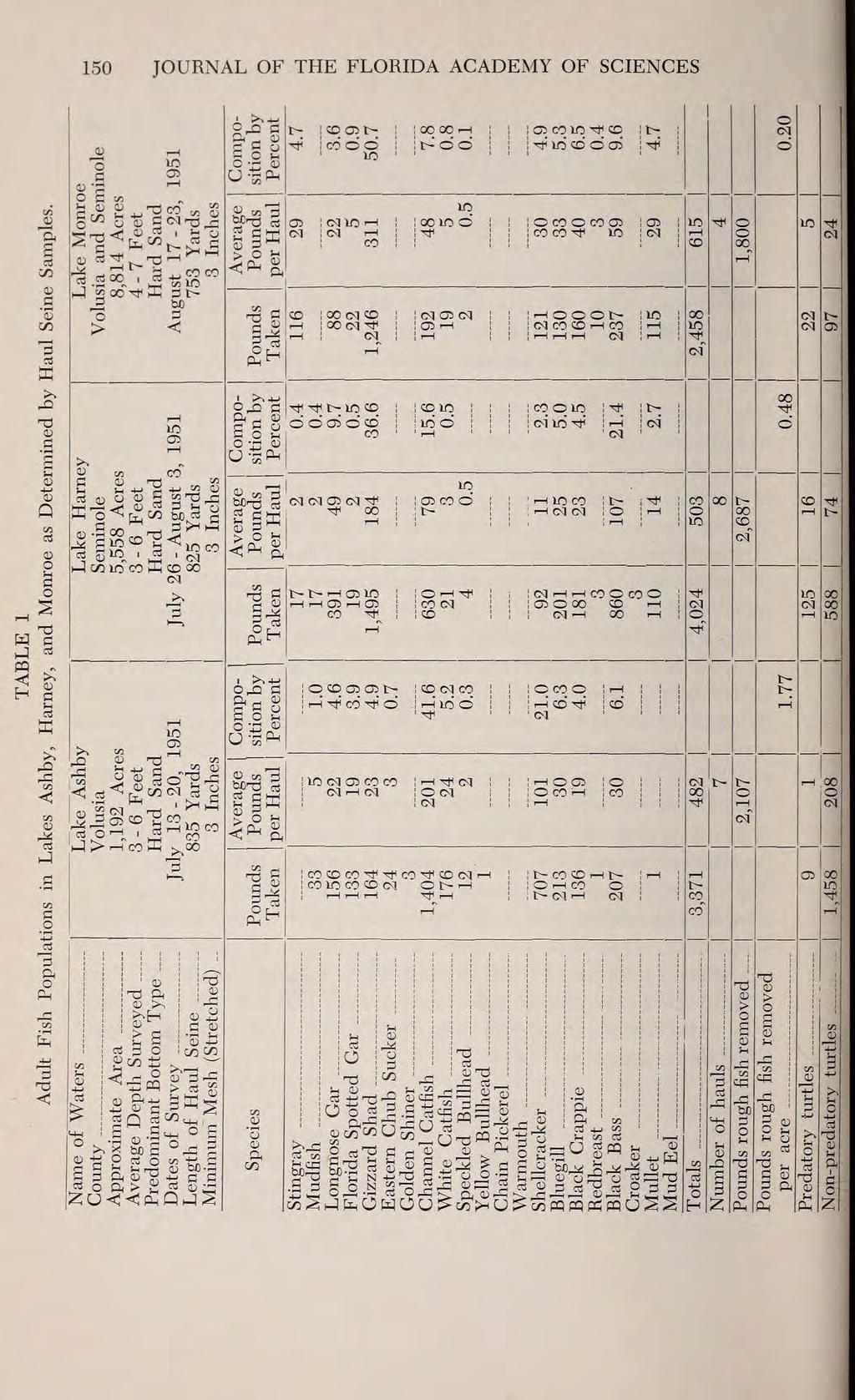
27 Seldom were any two hauls alike. Weather conditions, bottom characteristics, state of the net, and fishermen's vagaries were some of the factors affecting the area of the haul ground pulled and fishing success. It is believed that the circumstances which affected fishing success did not bias the data. Therefore: (1) the amounts of fish caught by the rough fish net are considered representative of the populations within the net selectivity in each lake during the period of study, and (2) the populations thus determined for one lake are compared quantitatively as well as qualitatively with those similarly determined in another lake at about the same season of the year. It is admitted that the comparisons may be very approximate ones, but it is felt that within the limitations of the data they are dependable. [Begin Page: Page 149] ADULT FISH POPULATIONS IN SEVEN FLORIDA LAKES 149 The lakes are summarized in terms of average pounds of fish taken per haul during the given periods, and in terms of the percentage composition by weight of each species taken in that average haul. Lake Ashby
28 Lake Ashby, in Volusia County, has an area of 1,192 acres or 1.86 square miles. It is a shallow saucer-shaped lake with wide sandy beaches in a pine flatwoods region. The average depths in the central area during the period of stay were five to six feet. The water stage was moderately low. Littoral areas were extensive, and consisted partly of sloughs and swamps. The bottom was chiefly of hard sand, although some black mud, varying in depth from about two inches to two feet, was present in a few places. Mussels were observed living on the bottom of the lake in considerable numbers. A light plankton bloom was present in the water at the time of operations. Maiden cane (Panicum sp.) grew on the edges of the beach and some eel grass (Vallisneria americana) was found in a few areas in the lake. In times of moderately high water Lake Ashby is remotely connected with the St. Johns River by a branch of Deep Creek which flows from Lake Harney and enters Ashby from the south. This branch goes periodically dry when the River is at a low stage. On the west shore a canal drains water from adjacent low flatwoods into the lake. On July 16, 1951 at 10:25 A.M. the water temperature was 90 F. and the air 89 F., the ph 7.0, dissolved oxygen 6.8 ppm, and C ppm. At the time of operations, in July 1951, available adult fish populations were low: 482 pounds constituted the average haul. The channel catfish (Ictalurus punctatus) was the most abundant species; it comprised 41.6 per cent by weight of the catch. The shellcracker (Lepomis microlophus) was the next most abundant species: it made up 21.0 per cent of the weight of the catch. Few gizzard shad (Dorosoma cepedianum) were taken at the time, and they represented about five per cent of the total weight caught.
29 For other species see Table 1. Lake Harney Lake Harney is in Seminole and Volusia Counties, and is part of the St. Johns River. It is an oblong saucer-shaped lake, in a pine flatwoods region, with about 8.73 square miles (5,558 acres) [Begin Page: Page 150] 150 JOURNAL OF THE FLORIDA ACADEMY OF SCIENCES A >"tt
30 c :3 a 03 r- ft i c 2 [Begin Page: Page 151] ADULT FISH POPULATIONS IN SEVEN FLORIDA LAKES 151 of surface area. Littoral areas were large and of the same general character as those of Lake Ashby. The bottom rose gently on all sides to the conspicuous, wide, sandy beaches. At mean low water the average depth in the middle is six feet. The water was at this stage during the period of operations. The bottom was a hard sand, covered in some places by several inches of black mud. Numerous mussels were observed living on the bottom. A light
31 plankton bloom was present in the water. Maiden cane was noted growing near the edges of the shore, and sparse growths of eel grass were found in the lake. On July 26, 1951 at 10:25 A.M. the ph of the water was 7.0; dissolved oxygen 4.20 ppm, and the temperature of the water was 84 F. when the air temperature was 85 F. Low populations of adult fishes were available to the seine during the period of operations July 26 to August 23, 1951 only 503 pounds were taken in the average haul. The predominant species found was gizzard shad, which composed 36.6 per cent by weight of the catch. Next in abundance was the largemouth bass, Micropterus salmoides floridanus (LeSueur), which represented 21.4 per cent by weight of the catch the highest percentage found in any of the seven lakes discussed. Channel catfish followed the bass in order of abundance, and comprised 15.6 per cent by weight of the catch. For average weights per haul and additional data see Table 1. Lake Monroe Lake Monroe is a part of the St. Johns River and is bounded by Seminole and Volusia Counties. It is about square miles (8,814 acres) in area, saucer-shaped and roughly circular in outline. The margins were gently sloping, with wide sandy beaches and extensive sloughs and marshes, resembling Lakes Ashby and Harney except for the bulkheaded shore on the Sanford side. The depth was fairly uniform it averaged about seven feet in the middle. The water stage was low during the operational period. The bottom type was predominantly hard sand, but a great deal of black mud
32 was present at the south end. No plankton bloom was noticeable in the water at the time of operations; Panicum and Vallisneria were present as in Lakes Ashby and Harney. On August 21, 1951 at 8:50 A.M. the ph was 7.0; dissolved oxygen 10.0 ppm; and the water temperature was 86 F. when the air temperature was 86 F. [Begin Page: Page 152] 152 JOURNAL OF THE FLORIDA ACADEMY OF SCIENCES Lake Monroe, like Lakes Harney and Ashby, yielded low adult fish populations during August pounds were taken in the average haul. The predominant species represented here was the gizzard shad, comprising 50.7 per cent by weight of the catch. Next in abundance, as in Lake Harney, was the largemouth bass, representing 9.6 per cent by weight of the catch. Again as in Lake Harney, channel catfish was third and composed 7.8 per cent by weight of the catch (Table 1). Lake Jessup Lake Jessup is approximately fifteen miles southeast of Sanford in Seminole County. It is square miles (7,922 acres) in size and is roughly crescent-shaped. Jessup is one of the St. Johns Chain of lakes, although it does not lie directly within the River, as do Lakes Harney and Monroe. It is connected to the River by a short channel on the eastern end. This channel is divided
33 by a muddy island. The lake is fed by a number of springs, some of them sulphurous, from its bed as well as from its shores. Littoral areas are very large, although the shore falls off less gently than that of Ashby, Harney, or Monroe. The margins are generally soft: sand and mud, with some shell. The entire eastern half is surrounded by a marshy margin about one-half mile in width which is composed of inlets, sloughs, and creeks. The western half has a more solid shoreline. The bottom of the lake is composed mostly of soft black mud, mixed with some sand, snail shells, and clay. It is not so uniform in depth as Ashby, Harney, and Monroe. At mean low water (the stage found during the unit's stay) the depth varies from three to seven feet. Adjacent to Bird Island, in the middle of the lake, the bottom was of hard sand and sloped up gently to a water depth of about a foot within two hundred feet of the island. The lake was colored with a fairly heavy greenish plankton bloom at the time of operations. Luxuriant grasses and emergents grew along the shallow places near the shore, and there were numerous beds of eel grass in the lake. On September 10, 1951, at 11:45 A.M., the ph of the water was 7.5, the water temperature 84 F. and the air 84 F. Dissolved oxygen was ppm, and C ppm. In Lake Jessup large numbers of fishes were available to the net during the period August 29 to October 9, The average [Begin Page: Page 153]
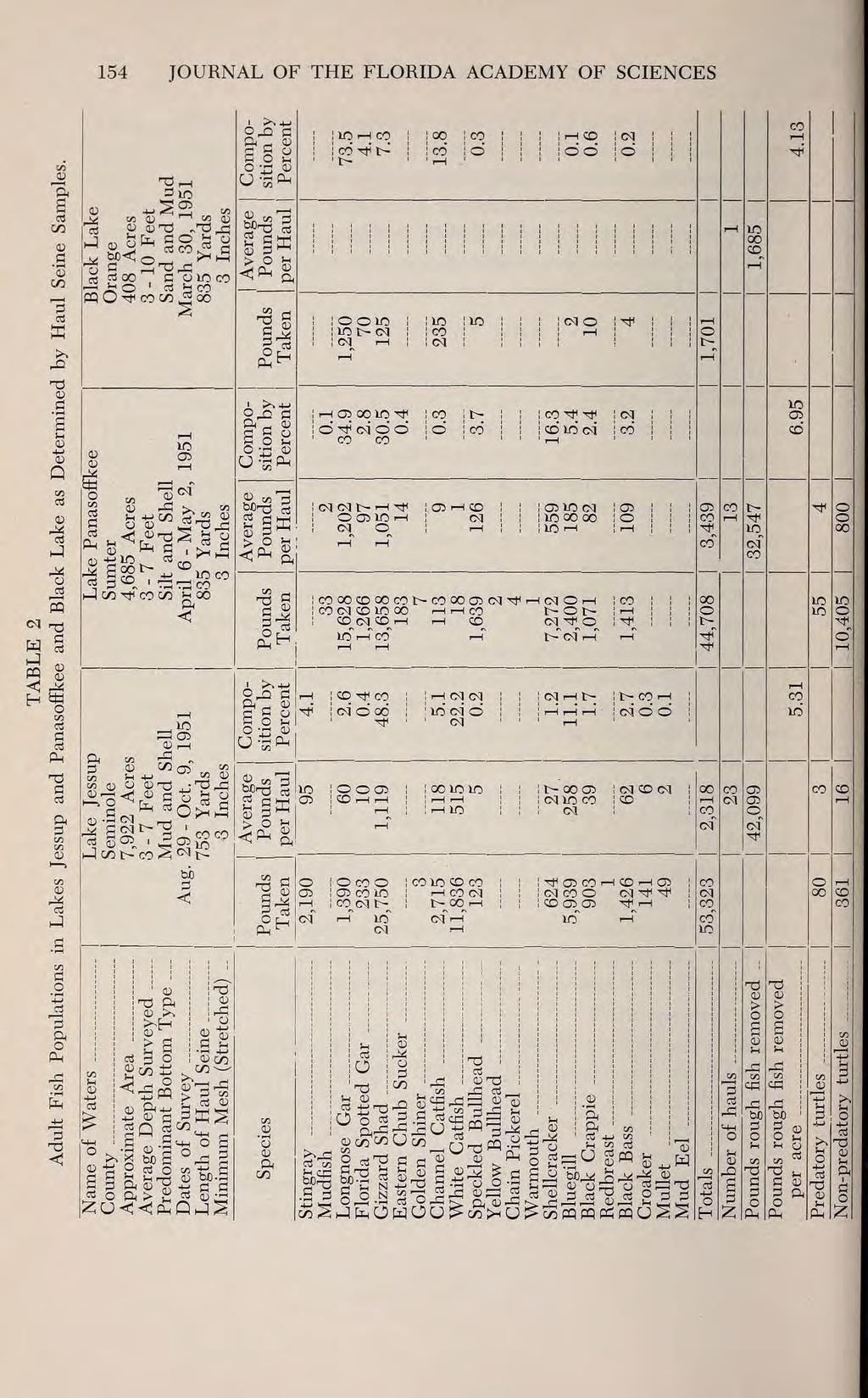
34 ADULT FISH POPULATIONS IN SEVEN FLORIDA LAKES 153 weight per haul was 2,318 pounds. Gizzard shad was the dominant species and comprised 48.3 per cent of the total weight of the catch. White catfish, Ictalurus catus, was the species second most abundant, and represented 22.2 per cent by weight. Bluegill was third 11.1 per cent; and channel catfish, stingray, longnose gar, black bass, and black crappie followed, respectively, in order of abundance (Table 2). Lake Panasoffkee In Sumter County about six miles north of Bushnell lies Lake Panasoffkee with an area of 7.32 square miles (4,685 acres). It is situated in a climax hammock region of many large oaks, hickories, and magnolias, and is surrounded by extensive cypress and sawgrass marshes. Panasoffkee is a kidney-shaped lake directly connected with the Withlacoochee River by the Panasoffkee River, which drains the lake from its west shore. The lake is relatively shallow, and at the time of operations had an average depth of about five feet (a low water stage). The bottom is composed of a deep, soft, yellowish silt. Large dense beds of eel grass were present in the lake and were especially thick and wide at its northern and southern ends, and on the eastern side. Personal observation revealed a pronounced green plankton bloom manifested in the water through the fall, spring, and summer months. The lake supported a dense population of the snail, Vivipara g. 9 and considerable numbers of mussels. The water is derived principally
35 from springs. At the time of operations it exhibited a milky appearance underlying its greenish plankton layer. Littoral areas are extensive, and large beds of giant pickerel weeds (Pontederia sp.) figure prominently in the dense vegetation. From the marshy saw-grass ringed shoreline the silty bottom slopes gently to five foot depths. On May 1, 1951 the water temperature was 78 when the air was 75 F., the ph was 8.3, dissolved oxygen 7.6 ppm, and C0 2, zero ppm. Lake Panasoffkee exhibited high fish populations during April and the first two days in May The average weight per haul was 3,439 pounds. The species of fish taken most abundantly was the longnose gar, Lepisosteus osseus, which represented 34.9 per cent by weight of the catch. Second in abundance was the gizzard shad, composing 30.5 per cent. Shellcracker ranked third 16.3 per cent; and bluegill fourth, comprising 5.4 per cent (Table 2). [Begin Page: Page 154] 154 JOURNAL OF THE FLORIDA ACADEMY OF SCIENCES Black Lake Orange 408 Acres 3-10 Feet Sand and Mud March 30, 1951
36 CO H o Oj np 0) Pm [Begin Page: Page 155] ADULT FISH POPULATIONS IN SEVEN FLORIDA LAKES 155 An outstanding fact about Lake Panasoffkee was the abundance of the hard-shell turtle or "cooter", Fseudemys fioridana peninsularis. In no other lake, to the writer's knowledge, was it found so abundantly. A total weight of 10,405 pounds were taken, representing 18.9 per cent of the combined weight of the catch. The weight of the average cooter was about eight pounds. Johns Lake
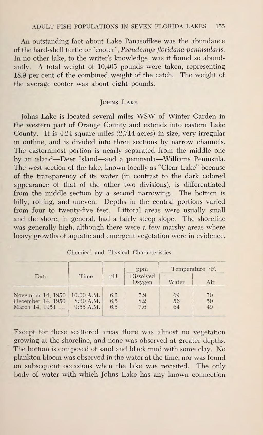
37 Johns Lake is located several miles WSW of Winter Garden in the western part of Orange County and extends into eastern Lake County. It is 4.24 square miles (2,714 acres) in size, very irregular in outline, and is divided into three sections by narrow channels. The easternmost portion is nearly separated from the middle one by an island Deer Island and a peninsula Williams Peninsula. The west section of the lake, known locally as "Clear Lake" because of the transparency of its water (in contrast to the dark colored appearance of that of the other two divisions), is differentiated from the middle section by a second narrowing. The bottom is hilly, rolling, and uneven. Depths in the central portions varied from four to twenty-five feet. Littoral areas were usually small and the shore, in general, had a fairly steep slope. The shoreline was generally high, although there were a few marshy areas where heavy growths of aquatic and emergent vegetation were in evidence. Chemical and Physical Characteristics Time ph ppm_ Dissolved Oxygen Temperature F.
38 Except for these scattered areas there was almost no vegetation growing at the shoreline, and none was observed at greater depths. The bottom is composed of sand and black mud with some clay. No plankton bloom was observed in the water at the time, nor was found on subsequent occasions when the lake was revisited. The only body of water with which Johns Lake has any known connection [Begin Page: Page 156] 156 JOURNAL OF THE FLORIDA ACADEMY OF SCIENCES co CO 1 X >> r T3
39 3 jj Tj _Q cocc^ 1! 2; in ^o^utd W d^^ O ft > g «$ co^5 >, 2cS 5-^ CO S ij fe O W O U > co >h O ^ co PQ cq p^ pq U S S [Begin Page: Page 157] ADULT FISH POPULATIONS IN SEVEN FLORIDA LAKES 157 is Black Lake, about a mile to the east. It is joined to it by a canal draining a marsh between the two lakes. The seine hauls pulled in Johns Lake are separated into three groups: (1) unbaited ones made at random in the lake during the first period of operations, (2) baited ones made at a single location during the first period, and (3) random unbaited hauls made about two months later.
40 Random hauls made during the first period yielded high fish populations the average weight per haul was 2,156 pounds (Table 3). Channel catfish was the dominant species taken, and composed 43.7 per cent of the weight of the catch. Second most abundant was the gizzard shad, 24.4 per cent of the combined weight of populations caught. Third was the bluegill, 12.6 per cent of the total weight. Longnose gar was fourth, largemouth bass fifth, white catfish sixth, and black crappie (Pomoxis nigromaculatus) seventh. In the second period of operations, after a two months lapse of time, random hauls yielded smaller total populations. The average weight per haul had dropped to 1,280 pounds. The dominant species remained the channel catfish, but it comprised only 29.3 per cent by weight of the catch. Bluegill had become the second most abundant species it represented 20.4 per cent of the weight taken. Third, fourth, and fifth in order of abundance were, respectively, gizzard shad, white catfish, and speckled bullhead. Sixth and seventh were longnose gar and black crappie (Table 3). Johns Lake was the only lake extensively baited for catfishes included in this study. The purpose of baiting is to attract large numbers to an area. The area should be baited repeatedly so as to accustom them to come there to feed. The haul ground area selected in Johns Lake was baited every day for a week before the first haul was made, and was baited daily and fished about twice a week thereafter. All the gizzard shad, garfishes, and other rough fishes (with the exception of catfishes, no parts of which
41 were used for bait) caught were cooked, salted, and placed in the baited area. Seine hauls were made early in the morning before the "cats" had a chance to leave after eating the bait. Baited hauls in Johns Lake proved extremely successful. The average weight per haul of all fishes was 2,230 pounds, of which 88.7 per cent by weight consisted of catfishes. The principal species [Begin Page: Page 158] 158 JOURNAL OF THE FLORIDA ACADEMY OF SCIENCES caught was the channel catfish, which represented 80.5 per cent by weight of the catch. Second was the white catfish, 8.0 per cent; third, the bluegill, 4.9 per cent; fourth, gizzard shad, 3.5 per cent; black crappie, fifth, 1.6 per cent; and black bass, sixth, 0.7 per cent by weight of the total catch. No longnose garfish were caught from baited hauls in Johns Lake (Table 3). Black Lake Black Lake lies about a mile east of Johns Lake and is located in Orange County. It was 0.64 square miles (408 acres) in size, and was roughly circular in shape. Littoral areas were wide, the lake was shallow four to five feet deep in the middle; the bottom was chiefly of sand with some black mud. No plankton bloom was observed on its waters, which like those of most of Johns Lake were
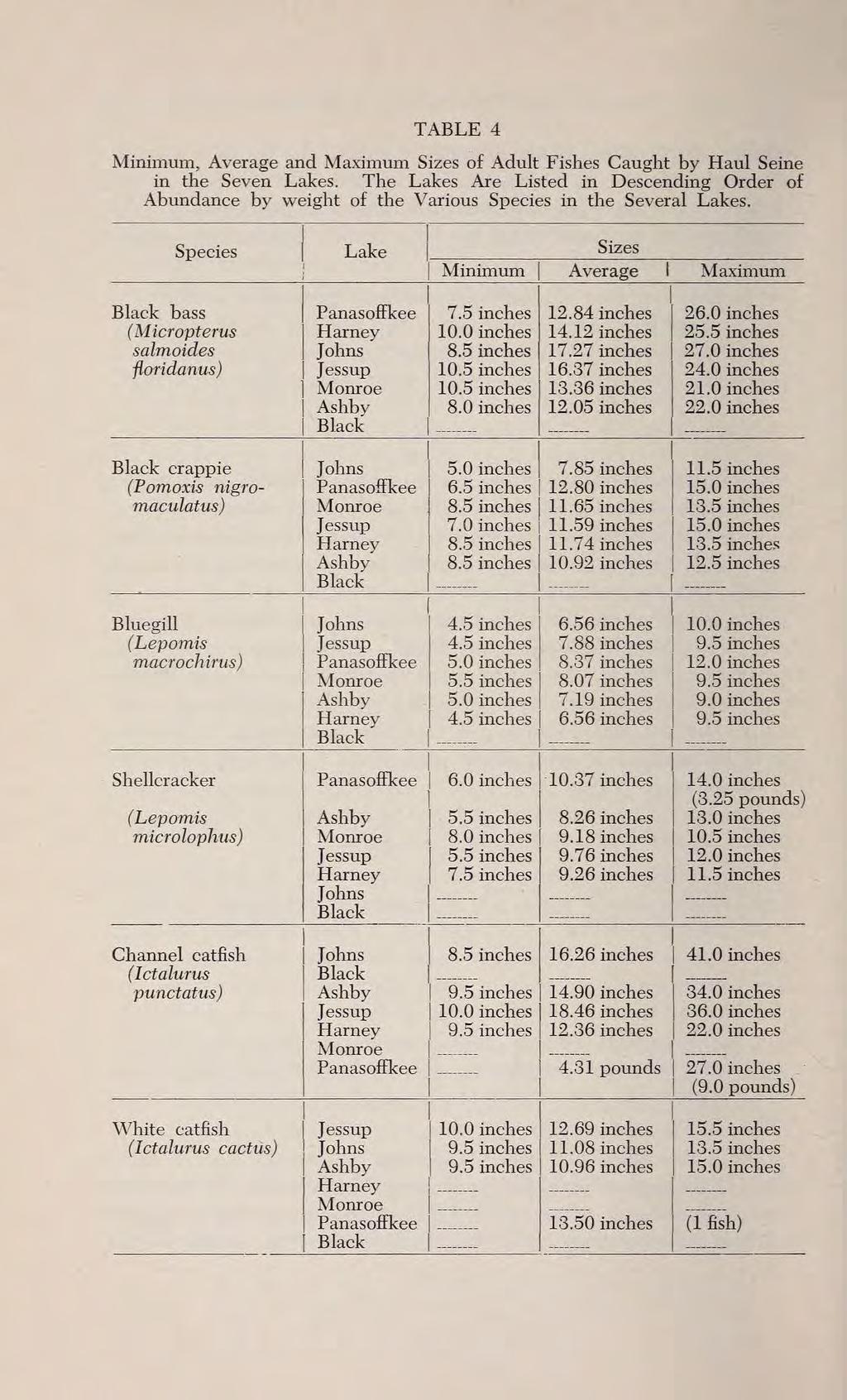
42 dark colored in appearance. Some maiden cane grew along the shoreline, together with pickerel weed and other emergents. There is a large marsh contiguous with Black Lake extending eastward approximately three miles. Black Lake is connected directly with Johns by a canal about a mile long. A single haul was made in Black Lake. Because of the lake's small size and because the haul was pulled near its central part, it is believed that the sample can be considered representative of the fish populations available to the net on March 30, The total weight of all fishes taken was 1,701 pounds: 73.5 per cent of this weight consisted of longnose gar; 13.8 per cent, of channel catfish; and 7.3 per cent of gizzard shad. Black crappie, bluegill, and black bass, jointly, represented only about 0.9 per cent of the total weight of the catch (Table 2). Size Distributions Size distributions among the populations of the several species are summarized in Table 4. The average lengths presented were determined from length-frequency data by multiplying the number of fish measured in each size group by the total-length measurement of that size group, summing up the products and dividing by the total number of fish in the sample. Occasionally where average lengths were not available, average weights are presented instead, and in the few cases where data were available the average
43 [Begin Page: Page 159] ADULT FISH POPULATIONS IN SEVEN FLORIDA LAKES 159 weight corresponding to the average length of the species in question is also given. It is regrettable that the volume of work attendant on the supervision of the rough fish unit precluded lengthweight studies, particularly for the bass, bream, and crappie, which had to be released alive. It is believed that the size distributions presented in Table 4 may be considered representative for the populations of the lakes during the periods of study. Large samples were generally taken for analysis, and efforts were made to keep them uniformly random. Comparison In drawing comparisons from lake to lake it should be recognized that the abundance of fishes available to the haul seine in a given body of water is subject to "seasonal and cyclic fluctuations" (Dequine 1951) caused perhaps principally by fish movements in connection with spawning and feeding activities which lead them to shallow water where the seine cannot go, or even outside the lake itself (H. L. Moody, Unpublished Data). It is apparent, therefore, that bodies of water sampled at about the same time of year should be more readily comparable than bodies sampled at different times. Ashby, Harney, and Monroe are logically comparable in this re-
44 spect; Panasoffkee is comparable with Black Lake; and, although the sampling in Jessup was done in early fall almost a year after the first period of operations in Johns in late fall, striking over-all population similarities justify their comparison. Lakes Harney and Monroe, similar type lakes in the St. Johns River, yielded nearly equal yet low average poundages of fishes to the sampling device, and there was a close similarity in their species composition. The three most abundant fishes in the two lakes were respectively, gizzard shad, black bass, and channel catfish. Nearby Lake Ashby, of the same bottom type as the former lakes, yielded about the same total average poundages, but yielded an extremely low shad population. Channel catfish and shellcracker were, respectively, the two most abundant species taken in Lake Ashby. Lake Panasoffkee and Black Lake are similar in two respects only: (1) the high proportions of garfishes present and (2) the high average poundages taken. The 1,320 pounds of garfishes caught in Black Lake represented 77.6 per cent of the total weight of the [Begin Page: Page 160] TABLE 4 Minimum, Average and Maximum Sizes of Adult Fishes Caught by Haul Seine in the Seven Lakes. The Lakes Are Listed in Descending Order of
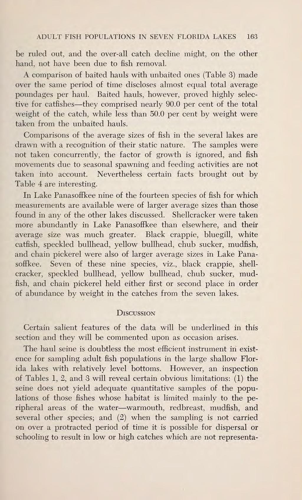
45 pounds of garfishes amounted to only 37.7 per cent of the total weight. In Black Lake the garfishes greatly outweighed all the other species caught, while in Panasoffkee they represented about one-third of the total weight. Lake Jessup (August-October 1951) and Johns Lake during the first period (November-December 1950) produced about the same total average poundages of fishes to the haul. The two principal species, in order of abundance by weight, were gizzard shad and white catfish in Jessup, and channel catfish and gizzard shad in Johns Lake. In both lakes bluegill, longnose gar, and black bass represented the next most important segments of the populations. The removal of pounds of rough fishes per surface acre of water from Johns Lake (Table 3) during November and December 1950 may have accounted for the decline in the average catch per haul in March 1951, since this decline was nearly identical with the decline in the average pounds taken per haul of rough fishes, and the average weight per haul of game fishes taken showed an increase during the second period (Table 5). However, the cyclic, seasonal fluctuations of abundance previously mentioned cannot TABLE 5 Comparisons of Poundages of Fish Taken During Two Periods of Stay in Johns Lake. November 15 -
46 December 28, 1950 March 14-28, 1951 Differences Average weight per haul all fishes (includes baited and unbaited hauls) Average weight per haul rough fishes removed: principally channel catfish, white catfish, gizzard shad, and garfishes Average weight per haul game fishes taken: principally bass, crappie, bluegill, and shellcracker 2,177 pounds 1,812 pounds
47 365 pounds 1,280 pounds 894 pounds 386 pounds 897 pounds (decline) 918 pounds (decline) 21 pounds (increase) [Begin Page: Page 163] ADULT FISH POPULATIONS IN SEVEN FLORIDA LAKES 163 be ruled out, and the over-all catch decline might, on the other hand, not have been due to fish removal. A comparison of baited hauls with unbaited ones (Table 3) made over the same period of time discloses almost equal total average poundages per haul. Baited hauls, however, proved highly selec-
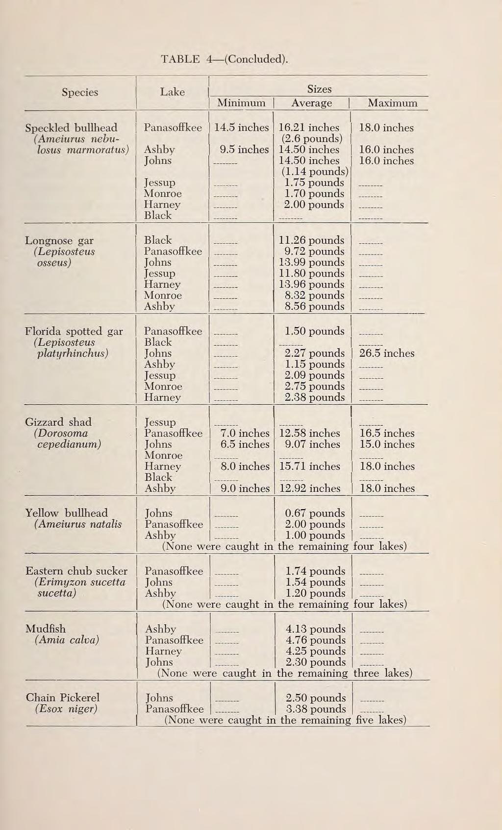
48 tive for catfishes they comprised nearly 90.0 per cent of the total weight of the catch, while less than 50.0 per cent by weight were taken from the unbaited hauls. Comparisons of the average sizes of fish in the several lakes are drawn with a recognition of their static nature. The samples were not taken concurrently, the factor of growth is ignored, and fish movements due to seasonal spawning and feeding activities are not taken into account. Nevertheless certain facts brought out by Table 4 are interesting. In Lake Panasoffkee nine of the fourteen species of fish for which measurements are available were of larger average sizes than those found in any of the other lakes discussed. Shellcracker were taken more abundantly in Lake Panasoffkee than elsewhere, and their average size was much greater. Black crappie, bluegill, white catfish, speckled bullhead, yellow bullhead, chub sucker, mudfish, and chain pickerel were also of larger average sizes in Lake Panasoffkee. Seven of these nine species, viz., black crappie, shellcracker, speckled bullhead, yellow bullhead, chub sucker, mudfish, and chain pickerel held either first or second place in order of abundance by weight in the catches from the seven lakes. Discussion Certain salient features of the data will be underlined in this section and they will be commented upon as occasion arises.
49 The haul seine is doubtless the most efficient instrument in existence for sampling adult fish populations in the large shallow Florida lakes with relatively level bottoms. However, an inspection of Tables 1, 2, and 3 will reveal certain obvious limitations: (1) the seine does not yield adequate quantitative samples of the populations of those fishes whose habitat is limited mainly to the peripheral areas of the water warmouth, redbreast, mudfish, and several other species; and (2) when the sampling is not carried on over a protracted period of time it is possible for dispersal or schooling to result in low or high catches which are not representa- [Begin Page: Page 164] 164 JOURNAL OF THE FLORIDA ACADEMY OF SCIENCES tive of the true value of the productivity, or of the size of the populations of a given body of water. Low catches in Lakes Ashby, Harney, and Monroe during July and August 1951 could be illustrative of the latter case. It is interesting to note by comparison that during the period of the "Controlled Seining Program" in Lake Crescent (July 1952 to February 1953) the average catch per haul was similarly low in July, August, and September, but more than tripled in weight during the months of November, December, and January (Dequine 1953). It seems extremely probable, therefore, that had the sampling continued over a longer period in Ashby, Harney, and Monroe similar catch
50 increases would have become evident. Schoolings and dispersals of fish in Florida's fresh waters cannot be predicted since their causes are not definitely known, but directed and integrated investigation cannot fail to uncover these secrets. Tagging studies now in progress should do much to determine whether fish leave or enter lakes in large numbers, or, alternately, whether they merely move into and out of areas of availability within them. The close correspondence in average pounds per haul, and in the species composition of the catch in Harney and Monroe suggest that the linkage of these lakes by the St. Johns River might be the cause of a homogeneity in their populations. Interesting differences in the populations of the several lakes raise many unanswered questions. Why, for example, was the population of Johns Lake composed principally of channel catfish, when catfishes of all species were extremely scarce in Panasoffkee? Was the tremendous abundance of the hard-shelled cooter in Panasoffkee associated with the presence of huge beds of eel-grass? Could the marsh contiguous with Black Lake be a factor contributing to its large garfish population? What reason could be advanced to explain the large sizes of the fish in Panasoffkee? Why did Lake Jessup yield large poundages of fish to the unit haul while nearby lakes in the same chain yielded low poundages? Why was the gizzard shad scarce in Lake Ashby, when in all the other lakes, with the exception of Black Lake, it came close to being the dominant species?
51 Nearly all these lakes have an admitted past history of commercial seining and, in some, rumor has it continuing illegally at the time of this writing. Needless to say it is not possible to secure [Begin Page: Page 165] ADULT FISH POPULATIONS IN SEVEN FLORIDA LAKES 165 data from such operations. Perhaps significant changes have been brought about by large scale "manipulations" of the populations. If the past history of these and other lakes were definitely known a great contribution would have been made toward intelligent management of Florida's fresh water fishing. Johns Lake is the only lake in this study from which rough fish were removed by haul seine where it was possible to return at a later period and compare results. After removing 45,384 pounds of rough fish (chiefly channel catfish), or pounds per acre of total water surface (Table 3) the net left at the end of December 1950 and returned two and one-half months later. It was found that the average catch per haul was reduced to nearly one-half that of the first period, and that the combined weight of rough fishes per average haul was also reduced by about one-half (Table 5). Here the net appeared astonishingly effective in reducing the populations of rough fishes. The slight rise in average weight per haul of game fishes is probably not significant as a real increase
52 since insufficient time had elapsed between the two periods for reproduction to occur. Conclusion The haul seine is a useful and efficient tool for sampling adult fish populations in shallow level bottom Florida lakes. In five of the seven lakes discussed, garfishes and gizzard shad constituted about half or more of the total weights of the populations taken. In all seven of the lakes, rough fishes, including catfishes, composed sixty per cent or more of the total weight of the catch. Summary Fish population studies were made by the author in Lakes Ashby, Harney, Monroe, Jessup, Panasoffkee, Johns Lake, and Black Lake by means of a rough fish removal unit employing a haul seine of about 800 yards in length, deep enough to fish the bottom, and with a minimum mesh size of three inches, stretched measure. The minimum average water depth in which the net was used was about three feet, and the maximum twelve. The mesh size permitted no fishes smaller than those of the size of bluegills of 4.5 inches in total length to be taken. Harney and Monroe in the St. Johns River chain yielded low fish populations. Gizzard shad made up the bulk of the catch
53 [Begin Page: Page 166] 166 JOURNAL OF THE FLORIDA ACADEMY OF SCIENCES in both lakes. Lake Ashby also yielded low populations; channel catfish and shellcracker were the more abundant species. Lake Jessup, connected with the St. Johns River, was found to have high populations, but about fifty per cent of the catch was gizzard shad, and about twenty-seven per cent catfishes. Lake Panasoffkee hauls revealed high fish populations, but about seventy per cent of the catch was composed of rough fishes, principally gizzard shad and garfishes. Despite this fact the average sizes of the individuals of numerous species, particularly the shellcracker, were larger than those found in the other lakes. The hard-shelled cooter, Pseudemys, was taken in very large numbers. The fish populations in Johns Lake were dominanted by the channel catfish and the gizzard shad. Baiting a haul area for catfishes was practiced with considerable success. A check on the effectiveness of the rough fish removal here was made possible by a re-entry two and onehalf months later. The catch of rough fish was found reduced by one-half. In Black Lake more than seventy-seven per cent of the total weight of the populations taken consisted of garfishes, and about one per cent of gamefishes. List of Species Taken Fishes: Stingray: Dasyatis spp.
54 Mudfish: Amia calva Linnaeus Longnose Gar: Lepisosteus osseus (Linnaeus) Florida Spotted Gar: Lepisosteus platyrhinchus DeKay Gizzard Shad: Dorosoma cepedianum (LeSueur) Eastern Chub Sucker: Erymyzon sucetta sucetta (Lacepede) Golden Shiner: Note?nigonus crysoleucas bosci (Cuvier and Valenciennes) Channel Catfish: Ictalurus punctatus (Rafinesque) White Catfish: Ictalurus catus (Linnaeus) Speckled Bullhead: Ameiurus nebulosus marmoratus (Holbrook) Yellow Bullhead: Ameiurus natalis Jordan Chain Pickerel: Esox niger LeSueur Warmouth: Chaenobryttus coronarius (Bartram) Shellcracker: Lepomis microlophus (Gunther) Bluegill: Lepomis macrochirus purpurescens Cope Black Crappie: Pomoxis nigromacidatus (LeSueur) Redbreast: Lepomis auritus (Linnaeus) [Begin Page: Page 167] ADULT FISH POPULATIONS IN SEVEN FLORIDA LAKES 167 Black Bass: Micropterus salmoides floridanus (LeSueur) Croaker: Micropogon undulatus (Linnaeus) Mullet: Mugil spp.
55 Amphibians: Mud eel: Siren lacertina Linnaeus Reptiles: Florida cooter or "Hard-shelled" Turtle: Pseudemys floridana peninsulari Carr, and other spp. Southeastern Soft-shelled Turtle: Amy da ferox (Schneider) Acknowledgments The writer wishes to express gratitude to William M. McLane and Melvin T. Huish of the Florida Fish Management Division for encouragement and advice in the preparation of the manuscript, and to Eva M. Bryan, who did the typing and offered many helpful suggestions. Literature Cited DEQUINE, JOHN F Fisheries Investigations of the St. Johns River and Lake Okeechobee, , with Recommendations for Management. Fla. Game & Fresh Water Fish Comm., 48 pp; 7 tables; 5 figs.; 1 form. (Mimeographed.)
56 1953. Preliminary Progress Report on Florida's Controlled Seining Program, 1 April 1952 through 28 February A Report to the Director and Members of Fla. Game & Fresh Water Fish Comm. Fla. Game & Fresh Water Fish Comm., 31 pp.; 4 tables; 6 figs. (Mimeographed.) Quart. Jour. Fla. Acad. Sci., 17(3), 1954.
Factors Affecting the Reproduction of Bluegill Bream and Largemouth Black Bass in Ponds
 CIRCULAR NO. 87FERAY14 FEBRUARY 1943 Factors Affecting the Reproduction of Bluegill Bream and Largemouth Black Bass in Ponds H-. S. SWINGLE, Fish C'ulturist and E. V. SMITH, Associate Botanist AGRICULTURAL
An Assessment of the Fish Community in Lake Acworth
 An Assessment of the Fish Community in Lake Acworth By John Damer Fisheries Biologist Georgia Department of Natural Resources Wildlife Resources Division Fisheries Section Calhoun, GA 30701 July 2008 Introduction
LAKE DIANE Hillsdale County (T8-9S, R3W, Sections 34, 3, 4) Surveyed May Jeffrey J. Braunscheidel
 Surveyed May Jeffrey J. Braunscheidel") Michigan Department of Natural Resources Status of the Fishery Resource Report No. 2003-4, 2003 LAKE DIANE Hillsdale County (T8-9S, R3W, Sections 34, 3, 4) Surveyed May 2001 Jeffrey J. Braunscheidel Environment
Michigan Department of Natural Resources Status of the Fishery Resource Report No. 2003-4, 2003 LAKE DIANE Hillsdale County (T8-9S, R3W, Sections 34, 3, 4) Surveyed May 2001 Jeffrey J. Braunscheidel Environment
Crooked Lake Oakland County (T4N, R9E, Sections 3, 4, 9) Surveyed May James T. Francis
 Surveyed May James T. Francis") Michigan Department of Natural Resources Status of the Fishery Resource Report No. 2004-1, 2004 Crooked Lake Oakland County (T4N, R9E, Sections 3, 4, 9) Surveyed May 2002 James T. Francis Environment Crooked
Michigan Department of Natural Resources Status of the Fishery Resource Report No. 2004-1, 2004 Crooked Lake Oakland County (T4N, R9E, Sections 3, 4, 9) Surveyed May 2002 James T. Francis Environment Crooked
Arizona Game and Fish Department Region VI Fisheries Program
 Arizona Game and Fish Department Region VI Fisheries Program Saguaro Lake Fish Survey Report April 18 th 21 st, 2016 Author: Bryant Dickens Report Date: July 7, 2016 The Arizona Game and Fish Department
Fish Survey of Goose Lake (ID # ), Ramsey County, Minnesota in 2012
, Ramsey County, Minnesota in 2012") Softshell Turtle from Goose Lake, July 2012 Fish Survey of Goose Lake (ID #62-0034), Ramsey County, Minnesota in 2012 Survey Dates: July 16-18, 2012 MnDNR Permit Number: 18362 Prepared for: VLAWMO and
Softshell Turtle from Goose Lake, July 2012 Fish Survey of Goose Lake (ID #62-0034), Ramsey County, Minnesota in 2012 Survey Dates: July 16-18, 2012 MnDNR Permit Number: 18362 Prepared for: VLAWMO and
JadEco, LLC PO BOX 445 Shannon, IL 61078
 Introduction: With the assistance of Lake Holiday staff and volunteers, we were able to conduct an AC electrofishing survey on May 8, 27. Water temperatures were 2.3 C (8.5 F) and water clarity was decent
AN ANALYSIS OF FISHING EFFORT AT INDIAN LAKE
 AN ANALYSIS OF FISHING EFFORT AT INDIAN LAKE LOWELL E. BINKLEY.i Section of Fish Management and Propagation, Ohio Division of Conservation and Natural Resources, Columbus, Ohio Although the study of natural
Michigan Dept. of Natural Resources Status of the Fishery Resource Report Page 1. Weber Lake Cheboygan County, T34N, R3W, Sec.
 Michigan Dept. of Natural Resources 2012-143 Status of the Fishery Resource Report Page 1 Weber Lake Cheboygan County, T34N, R3W, Sec. 31 Neal Godby, Fisheries Biologist Environment Weber Lake is a 28.5-acre
Pascagoula River Marsh 2018 REEL FACTS Stephen Brown Fisheries Biologist
 Pascagoula River Marsh 218 REEL FACTS Stephen Brown Fisheries Biologist stephenb@mdwfp.state.ms.us General Information: The Pascagoula River marsh is 25 acres of tidal creeks, canals, bays, and streams
NEVADA DEPARTMENT OF WILDLIFE STATEWIDE SPORT FISHERIES MANAGEMENT
 NEVADA DEPARTMENT OF WILDLIFE STATEWIDE SPORT FISHERIES MANAGEMENT FEDERAL AID JOB PROGRESS REPORT F-20-49 2013 Urban Sport Fisheries SOUTHERN REGION NEVADA DEPARTMENT OF WILDLIFE, FISHERIES DIVISION ANNUAL
MIDDLE FORK RESERVOIR Wayne County 2004 Fish Management Report. Christopher C. Long Assistant Fisheries Biologist
 MIDDLE FORK RESERVOIR Wayne County 2004 Fish Management Report Christopher C. Long Assistant Fisheries Biologist FISHERIES SECTION INDIANA DEPARTMENT OF NATURAL RESOURCES DIVISION OF FISH AND WILDLIFE
MARTINDALE POND Wayne County 2004 Fish Management Report. Christopher C. Long Assistant Fisheries Biologist
 MARTINDALE POND Wayne County 2004 Fish Management Report Christopher C. Long Assistant Fisheries Biologist Fisheries Section Indiana Department of Natural Resources Division of Fish and Wildlife I.G.C.
Michigan Department of Natural Resources Status of the Fishery Resource Report Page 1
 Michigan Department of Natural Resources 2007-33 Status of the Fishery Resource Report Page 1 Grand Sable Lake Alger County, T49N, R14W, Sec. Many Lake Superior watershed, last year surveyed 2004 James
Delaware River Seine Survey: 2012 Sampling Summary
 Delaware River Seine Survey: 2012 Sampling Summary Fish and Wildlife employees pull in the seine net From June 18 to November 21, 2012, biologists conducted the Delaware River Seine Survey. Over the course
Cedar Lake Comprehensive Survey Report Steve Hogler and Steve Surendonk WDNR-Mishicot
 Cedar Lake- 2006 Comprehensive Survey Report Steve Hogler and Steve Surendonk WDNR-Mishicot ABSTRACT Cedar Lake is a 142 acre lake located in the southwest corner of Manitowoc County. It is a seepage lake
Current Status and Management Recommendations for the Fishery in the Cloverleaf Chain of Lakes
 Current Status and Management Recommendations for the Fishery in the Cloverleaf Chain of Lakes Jason Breeggemann Senior Fisheries Biologist Wisconsin Department of Natural Resources Outline DNR fisheries
Upper/Lower Owl Creek Reservoir
 Upper/Lower Owl Creek Reservoir Schuylkill County 2018 Largemouth Bass Survey Upper Owl Creek Reservoir and Lower Owl Creek Reservoir are 67-acre and 26-acre impoundments, respectively, created by two
NEVADA DEPARTMENT OF WILDLIFE STATEWIDE SPORT FISHERIES MANAGEMENT
 NEVADA DEPARTMENT OF WILDLIFE STATEWIDE SPORT FISHERIES MANAGEMENT FEDERAL AID JOB PROGRESS REPORT F-20-50 2014 Urban Sport Fisheries SOUTHERN REGION NEVADA DEPARTMENT OF WILDLIFE, FISHERIES DIVISION ANNUAL
Pascagoula River Marsh 2017 REEL FACTS Stephen Brown Fisheries Biologist
 Pascagoula River Marsh 217 REEL FACTS Stephen Brown Fisheries Biologist stephenb@mdwfp.state.ms.us General Information: The Pascagoula River marsh is 25 acres of tidal creeks, canals, bays, and streams
Warmwater Fisheries Assessments 2014
 NJDEP Division of Fish and Wildlife Bureau of Freshwater Fisheries Warmwater Fisheries Assessments 2014 New Jersey has over 400 impoundments open to the general public for fishing and thousands more in
DRIPPING SPRINGS LAKE 5 YEAR LAKE MANAGEMENT PLAN
 DRIPPING SPRINGS LAKE 5 YEAR LAKE MANAGEMENT PLAN FISHERIES DIVISION CENTRAL REGION OKLAHOMA DEPTMENT OF WILDLIFE CONSERVATION PREPARED BY: DANNY BOWEN OCTOBER 2013 1 Background Dripping Springs Lake impounds
Previous Stocking Black crappie. Channel catfish. Cutbow. Rainbow trout. Saugeye Black crappie. Channel catfish. Cutbow.
 Runyon Lake FISH SURVEY AND MANAGEMENT DATA Carrie Tucker - Aquatic Biologist (Pueblo) carrie.tucker@state.co.us / 719-561-5312 General Information: Runyon Lake, which is approximately thirty-five acres
Regulations. Grabbling season May 1 July 15; only wooden structures allowed.
 Enid Reservoir 218 REEL FACTS Keith Meals, Arthur Dunn, Stanley Turner Fisheries Biologists keithm@mdwfp.state.ms.us, ArthurD@mdwfp.state.ms.us, StanleyT@mdwfp.state.ms.us General Information: Enid Reservoir
Fish Communities in Five West Coast Spring-fed Rivers. Brandon Simcox, Eric Johnson, Amanda Schworm, Bill Pouder
 Fish Communities in Five West Coast Spring-fed Rivers Brandon Simcox, Eric Johnson, Amanda Schworm, Bill Pouder Project Overview FWC/SWFWMD partnership 3-yr funded project (thru June 2017) 5 spring-fed
Fish Survey of Arctic Lake (ID # ), Scott County, Minnesota in 2012
, Scott County, Minnesota in 2012") Snapping Turtle from Arctic Lake, September 2012 Fish Survey of Arctic Lake (ID #70-0085), Scott County, Minnesota in 2012 Survey Dates: September 18-20, 2012 MnDNR Permit Number: 18362 Prepared for: Shakopee
Snapping Turtle from Arctic Lake, September 2012 Fish Survey of Arctic Lake (ID #70-0085), Scott County, Minnesota in 2012 Survey Dates: September 18-20, 2012 MnDNR Permit Number: 18362 Prepared for: Shakopee
Quillback (Carpoides cyprinus)
") t. Joseph Assessment Appendix Quillback (Carpoides cyprinus) feeding - clear to turbid water - Michigan - sand, sandy gravel, sandy silt, or clay-silt substrate - medium- to low-gradient rivers and streams;
t. Joseph Assessment Appendix Quillback (Carpoides cyprinus) feeding - clear to turbid water - Michigan - sand, sandy gravel, sandy silt, or clay-silt substrate - medium- to low-gradient rivers and streams;
Thunder Bay River Assessment Appendix. Appendix 2
 Appendix 2 Known past and present fish distributions in the River system. Distribution of fishes were compiled from Bailey et al. (2003) and from records located at the Michigan Department of Natural Resources
NEVADA DEPARTMENT OF WILDLIFE STATEWIDE FISHERIES MANAGEMENT
 NEVADA DEPARTMENT OF WILDLIFE STATEWIDE FISHERIES MANAGEMENT FEDERAL AID JOB PROGRESS REPORTS F-20-49 2013 LAKE TAHOE WESTERN REGION NEVADA DEPARTMENT OF WILDLIFE, FISHERIES DIVISION ANNUAL PROGRESS REPORT
Columbia Lake Dam Removal Project
 Columbia Lake Dam Removal Project The Columbia Lake dam located 1/4 mile upstream of the Paulins Kill River's confluence with the Delaware River in Knowlton Township, Warren County has been proposed for
RECREATIONAL PONDS AND LAKES
 RECREATIONAL PONDS AND LAKES POND ECOLOGY AQUATIC PLANTS & FISH F.S. Conte Department of Animal Science University of California Davis Photos By Flickr AQUATIC PLANTS POND HEALTH Chemical Recycling Oxygen
Pennsylvania Fish & Boat Commission Biologist Report. Wilmore Dam. Cambria County. May 2011 Trap Net, Electrofishing and Hoop Net Survey
 Pennsylvania Fish & Boat Commission Biologist Report Wilmore Dam Cambria County May 2011 Trap Net, Electrofishing and Hoop Net Survey Wilmore Dam is a 195 acre impoundment located in central Cambria County
Quemahoning Reservoir
 Pennsylvania Fish & Boat Commission Biologist Report Quemahoning Reservoir Somerset County May 2011 Trap Net, Gill Net and Electrofishing Survey Quemahoning Reservoir is an 899 acre impoundment located
ASSESSMENT OF BLACK CRAPPIE AND WHITE PERCH IN HIGHLAND LAKE, STODDARD-WASHINGTON, NH (2014) New Hampshire
 New Hampshire") ASSESSMENT OF BLACK CRAPPIE AND WHITE PERCH IN HIGHLAND LAKE, STODDARD-WASHINGTON, NH (2014) STATE: GRANT: GRANT TITLE: JOB 9: New Hampshire F-50-R-31 Anadromous and Inland Fisheries Operational Management
ASSESSMENT OF BLACK CRAPPIE AND WHITE PERCH IN HIGHLAND LAKE, STODDARD-WASHINGTON, NH (2014) STATE: GRANT: GRANT TITLE: JOB 9: New Hampshire F-50-R-31 Anadromous and Inland Fisheries Operational Management
MEMORANDUM Comfort Lake-Forest Lake Watershed District
 MEMORANDUM Comfort Lake-Forest Lake Watershed District To: Board of Managers Date: December 7, 2016 From: Mike Kinney Subject: 2016 Watercraft Inspections and AIS Report Summaries Watercraft Inspection
7/29/2011. Sport fish. Rough fish. Fish Population Assessment
 Fish Population Assessment Sport fish Forage fish Rough fish 1 Question: How Do I Assess My Fish Population? Answer: Volkswagens to Corvettes!!! Volkswagen or Do-it-yourself Approach Keep catch records
Keystone Lakes November 20, 2014
 FISH SURVEY REPORT Keystone Lakes November 20, 2014 Prepared for: Keystone HOA 6231 Shoreham Drive Evansville, IN 47711 Prepared by: Aquatic Control Inc. P.O. Box 100 Seymour, IN 47274 November 2015 -
SOONER LAKE MANAGEMENT PLAN
 SOONER LAKE MANAGEMENT PLAN Background Lake Sooner impounds Greasy Creek, 15 miles south of Ponca City in Noble and Pawnee Counties, Oklahoma (Figure 1). The Grease Creek basin that Sooner Lake impounds
Tunica Cutoff 2018 REEL FACTS Keith Meals Fisheries Biologist
 Tunica Cutoff 218 REEL FACTS Keith Meals Fisheries Biologist keithm@mdwfp.state.ms.us General Information: Tunica Cutoff was created by the US Army Corps of Engineers (COE) in 1942 when a bend in the Mississippi
BENSON PARK POND FISH SPECIES
 BENSON PARK POND FISH SPECIES Bluegill (Lepomis macrochirus) From the Greek, lepomis means scaled gill cover and macrochirus means large hand, in reference to its body shape and size. Average adult size
Fisheries Survey of White Rapids Flowage, Marinette County Wisconsin during Waterbody Identification Code
 Fisheries Survey of White Rapids Flowage, Marinette County Wisconsin during 25 Waterbody Identification Code 6343 Michael Donofrio Fisheries Supervisor Wisconsin Department of Natural Resources Peshtigo,
Regulations. Grabbling season May 1 July 15; only wooden structures allowed.
 Sardis Reservoir 218 REEL FACTS Keith Meals, Arthur Dunn, Stanley Turner Fisheries Biologists keithm@mdwfp.state.ms.us, ArthurD@mdwfp.state.ms.us, StanleyT@mdwfp.state.ms.us General Information: Sardis
Pickwick Lake 2018 REEL FACTS Trevor Knight Fisheries Biologist (662)
") Pickwick Lake 218 REEL FACTS Trevor Knight Fisheries Biologist trevork@mdwfp.state.ms.us (662) 84-5176 General Information: Covering 43,1 acres, Pickwick Lake, which borders Alabama, Tennessee, and Mississippi,
Pickwick Lake 218 REEL FACTS Trevor Knight Fisheries Biologist trevork@mdwfp.state.ms.us (662) 84-5176 General Information: Covering 43,1 acres, Pickwick Lake, which borders Alabama, Tennessee, and Mississippi,
Comparative Survival of Pellet-Reared Muskellunge Stocked As Fingerlings In Bluegill Ponds With and Without Largemouth Bass
 1 9 2 0 Comparative Survival of Pellet-Reared Muskellunge Stocked As Fingerlings In Bluegill Ponds With and Without Largemouth Bass George B. Beyerle Fisheries Research Report No. 1920 April 23, 1984 MICHIGAN
BIG TWIN LAKE Kalkaska County (T28N, R05W, Section 18, and T28N, R06W, Section 13) Surveyed May 1999
 Surveyed May 1999") Michigan Department of Natural Resources Status of the Fishery Resource Report No. 2001-1, Year 2001 BIG TWIN LAKE Kalkaska County (T28N, R05W, Section 18, and T28N, R06W, Section 13) Surveyed May 1999
Michigan Department of Natural Resources Status of the Fishery Resource Report No. 2001-1, Year 2001 BIG TWIN LAKE Kalkaska County (T28N, R05W, Section 18, and T28N, R06W, Section 13) Surveyed May 1999
Lake Butte des Morts Commercial Seining Project Report
 Lake Butte des Morts Commercial Seining Project Report Adam Nickel, Winnebago Gamefish (excluding sturgeon) Biologist, 22 December 2014 Conducting comprehensive fish surveys on the Upriver Lakes, including
NEVADA DEPARTMENT OF WILDLIFE STATEWIDE FISHERIES MANAGEMENT
 NEVADA DEPARTMENT OF WILDLIFE STATEWIDE FISHERIES MANAGEMENT FEDERAL AID JOB PROGRESS REPORTS F-20-48 2012 LAKE TAHOE WESTERN REGION Contents NEVADA DEPARTMENT OF WILDLIFE, FISHERIES DIVISION ANNUAL PROGRESS
Manual of Fisheries Survey Methods II: with periodic updates. Chapter 22: Guidelines for Sampling Warmwater Rivers with Rotenone
 Manual of Fisheries Survey Methods II: with periodic updates : Guidelines for Sampling Warmwater Rivers with Rotenone P. W. Seelbach, G. L. Towns, and D. D. Nelson Suggested citation: Seelbach, Paul W.,
NEVADA DEPARTMENT OF WILDLIFE STATEWIDE FISHERIES MANAGEMENT
 NEVADA DEPARTMENT OF WILDLIFE STATEWIDE FISHERIES MANAGEMENT FEDERAL AID JOB PROGRESS REPORTS F-2-49 213 RYE PATCH RESERVOIR WESTERN REGION NEVADA DEPARTMENT OF WILDLIFE, FISHERIES DIVISION ANNUAL PROGRESS
Penny Road Pond Population Survey
 Located in Barrington Hills on the south side of Penny Rd. west of Old Sutton Rd. This small 7 acre pond has a maximum depth of 4.6 feet and is connected to Spring Creek. The fish population of Penny Road
LOUISIANA DEPARTMENT OF WILDLIFE & FISHERIES
 LOUISIANA DEPARTMENT OF WILDLIFE & FISHERIES OFFICE OF FISHERIES INLAND FISHERIES SECTION PART VI B WATERBODY MANAGEMENT PLAN SERIES LAKE FIELDS-LAKE LONG COMPLEX WATERBODY EVALUATION & RECOMMENDATIONS
NEVADA DEPARTMENT OF WILDLIFE STATEWIDE FISHERIES MANAGEMENT
 NEVADA DEPARTMENT OF WILDLIFE STATEWIDE FISHERIES MANAGEMENT FEDERAL AID JOB PROGRESS REPORTS F-2-52 216 CHIMNEY RESERVOIR WESTERN REGION NEVADA DEPARTMENT OF WILDLIFE, FISHERIES DIVISION JOB PROGRESS
Regulations. Grabbling season May 1 July 15; only wooden structures allowed.
 Grenada Reservoir 218 REEL FACTS Keith Meals, Arthur Dunn, Stanley Turner Fisheries Biologists keithm@mdwfp.state.ms.us, ArthurD@mdwfp.state.ms.us, StanleyT@mdwfp.state.ms.us General Information: Grenada
NEVADA DEPARTMENT OF WILDLIFE STATEWIDE FISHERIES MANAGEMENT
 NEVADA DEPARTMENT OF WILDLIFE STATEWIDE FISHERIES MANAGEMENT FEDERAL AID JOB PROGRESS REPORTS F-20-48 2012 RYE PATCH RESERVOIR WESTERN REGION NEVADA DEPARTMENT OF WILDLIFE, FISHERIES DIVISION JOB PROGRESS
Big Bend Lake Population Survey
 Big Bend Lake Survey Located in Des Plaines on East River Rd. just south of Golf Rd. This 27 acre body of water has a depth of 27.8 feet; however because it is connected to the Des Plaines River by a spillway,
Introduction: JadEco, LLC PO BOX 445 Shannon, IL 61078
 Introduction: was contacted to collected data on the fishery for Lake Holiday. AC Electroshocking was conducted at 2 locations on September 28, 2015. Fish population data was collected for a total of 100
Tittabawassee River Assessment. Miles. Gladwin Smallwood Impoundment. Harrison. Clare. Midland. Mt. Pleasant. St. Louis. Saginaw.
 Warmouth Lepomis gulosus feeding - clear lakes and impoundments and very low-gradient streams - abundant aquatic vegetation - silt-free water - mucky substrate often covered with organic debris spawning
ROANOKE RAPIDS LAKE CREEL SURVEY,
 ROANOKE RAPIDS LAKE CREEL SURVEY, 2013 2014 Federal Aid in Sport Fish Restoration Project F-108 Summary Report P-2009 Article 422 Kirk R. Rundle William J. Collart N. Corey Oakley Brian J. McRae North
Little Calumet River Rapid Response Fish Identification and Enumeration Branch Summary Report
 Little Calumet River Rapid Response Fish Identification and Enumeration Branch Summary Report Introduction A rotenone rapid response was completed on a 2.6-mile section of the Little Calumet River immediately
KICKAPOO LAKE Shakamak State Park Sullivan, Greene, and Clay Counties 2009 Fish Management Report. David S. Kittaka Fisheries Biologist
 KICKAPOO LAKE Shakamak State Park Sullivan, Greene, and Clay Counties 2009 Fish Management Report David S. Kittaka Fisheries Biologist Fisheries Section Indiana Department of Natural Resources Division
NURSERY POND Fish Management Report. Jason C. Doll Assistant Fisheries Biologist
 NURSERY POND 2004 Fish Management Report Jason C. Doll Assistant Fisheries Biologist FISHERIES SECTION INDIANA DEPARTMENT OF NATURAL RESOURCES DIVISION OF FISH AND WILDLIFE I.G.C. South, Room W273 402
EcoLogic Memorandum. TO: Ben Brezell; EDR FROM: Mark Arrigo RE: Possible Impacts of Dredging Snooks Pond DATE: 6/4/07
 EcoLogic Memorandum TO: Ben Brezell; EDR FROM: Mark Arrigo RE: Possible Impacts of Dredging Snooks Pond DATE: 6/4/07 Background EDR P.C. (EDR) has been contracted by a landowner to assess the feasibility
SKIATOOK LAKE MANAGEMENT PLAN
 SKIATOOK LAKE MANAGEMENT PLAN Background Skiatook Lake impounds Hominy Creek, 5 miles west of Skiatook in Osage County, Oklahoma (Figure 1). Skiatook Lake covers 10,540 surface acres and was constructed
O Malley s Ponds Population Survey
 O Malley s Ponds Survey The newest fishing lake within the Forest Preserves of Cook County, O Malley Ponds were acquired by the District in 2005. Located in Sauk Village at the intersection of Sauk Trail
NJ DIVISION OF FISH AND WILDLIFE Bureau of Freshwater Fisheries
 NJ DIVISION OF FISH AND WILDLIFE Bureau of Freshwater Fisheries 2015 Warmwater Reproduction Checks (Shoreline Seining) Alloway Lake (Salem) A seining survey was completed at Alloway Lake (120 acres) on
LITTLE WHITE OAK Knox County 2006 Fish Management Report. Debbie King Assistant Fisheries Biologist
 LITTLE WHITE OAK Knox County 2006 Fish Management Report Debbie King Assistant Fisheries Biologist Fisheries Section Indiana Department of Natural Resources Division of Fish and Wildlife I.G.C.-South,
Relative Size Selectivity of Trap Nets for Eight Species of Fish'
 North American Journal of Fisheries Management 2:33-37, 1982 Copyright by the American Fisheries Society 1982 Relative Size Selectivity of Trap Nets for Eight Species of Fish' PERCY W. LAARMAN AND JAMES
2014 Island Lake Survey June 13 th, 2014 Andrew Plauck District Fisheries Biologist Report Prepared 4 March 2015
 2014 Island Lake Survey June 13 th, 2014 Andrew Plauck District Fisheries Biologist Report Prepared 4 March 2015 BACKGROUND - A fish survey was requested due to a moderately severe winterkill in Island
ASSESSMENT OF WHITE PERCH IN LAKE WINNIPESAUKEE, TUFTONBORO (2016) Anadromous and Inland Fisheries Operational Management Investigations
 Anadromous and Inland Fisheries Operational Management Investigations") ASSESSMENT OF WHITE PERCH IN LAKE WINNIPESAUKEE, TUFTONBORO (2016) STATE: GRANT: GRANT TITLE: JOB 9: New Hampshire F-50-R-33 Anadromous and Inland Fisheries Operational Management Investigations Warmwater
ASSESSMENT OF WHITE PERCH IN LAKE WINNIPESAUKEE, TUFTONBORO (2016) STATE: GRANT: GRANT TITLE: JOB 9: New Hampshire F-50-R-33 Anadromous and Inland Fisheries Operational Management Investigations Warmwater
Comprehensive Fisheries Survey of High Falls Reservoir, Marinette County Wisconsin during 2004 and Waterbody Identification Code
 Comprehensive Fisheries of High Falls Reservoir, Marinette County Wisconsin during 2004 and 2005 Waterbody Identification Code 540600 Justine Hasz Senior Fisheries Biologist Wisconsin Department of Natural
2014 Threatened and Endangered Fish Survey of. East Loon Lake and West Loon Lake. Lake County, Illinois
 2014 Threatened and Endangered Fish Survey of East Loon Lake and West Loon Lake Lake County, Illinois Prepared by Integrated Lakes Management 120 LeBaron St. Waukegan, IL 60085. Chris Ryan Chris Rysso
MINNESOTA DEPARTMENT OF NATURAL RESOURCES DIVISION OF FISHERIES AND WILDLIFE. Gamefish Assessment Report
 Minnesota DNR F-29-R(P) Area F312 February 1, 2013 MINNESOTA DEPARTMENT OF NATURAL RESOURCES DIVISION OF FISHERIES AND WILDLIFE Gamefish Assessment Report Spring Gamefish Assessment on the Mississippi
MIDDLE FORK RESERVOIR Wayne County 2006 Fish Management Report. Christopher C. Long Assistant Fisheries Biologist
 MIDDLE FORK RESERVOIR Wayne County 2006 Fish Management Report Christopher C. Long Assistant Fisheries Biologist Fisheries Section Indiana Department of Natural Resources Division of Fish and Wildlife
Ross Barnett Reservoir 2018
 Ross Barnett Reservoir 18 Reel Facts Ryan Jones Fisheries Biologist Ryanj@mdwfp.state.ms.us (61) 89-341 General Information: Ross Barnett Reservoir is a 33, acre impoundment of the Pearl River. It consists
Cast Net Report. As required by Minnesota Statutes, section 97C.345, subdivision 3a, paragraph (c) 03/01/2018. Cast Net Report 1
 03/01/2018. Cast Net Report 1") Cast Net Report As required by Minnesota Statutes, section 97C.345, subdivision 3a, paragraph (c) 03/01/2018 Cast Net Report 1 Report to the Minnesota Legislature Minnesota Department of Natural Resources
Cast Net Report As required by Minnesota Statutes, section 97C.345, subdivision 3a, paragraph (c) 03/01/2018 Cast Net Report 1 Report to the Minnesota Legislature Minnesota Department of Natural Resources
Lake St. Clair Fish Community and Fishery
 Lake St. Clair Fish Community and Fishery Megan Belore Ontario Ministry of Natural Resources and Forestry Mike Thomas Michigan Department of Natural Resources Fish Community Fish Community Mixture of warm
Spring Lake 2017 REEL FACTS Keith Meals Fisheries Biologist
 Spring Lake 217 REEL FACTS Keith Meals Fisheries Biologist keithm@mdwfp.state.ms.us General Information: Spring Lake is a clear, shallow 6 acre spring-fed impoundment in Wall Doxey State Park. Nearly half
LAKE PLEASANT Steuben County 2006 Fish Management Report. Larry A. Koza Assistant Fisheries Biologist
 LAKE PLEASANT Steuben County 2006 Fish Management Report Larry A. Koza Assistant Fisheries Biologist Fisheries Section Indiana Department of Natural Resources Division of Fish and Wildlife I.G.C.-South,
EVALUATION OF THE FISH COMMUNITY AND GAME FISH POPULATIONS IN SUGAR CREEK (MONTGOMERY AND PARKE COUNTIES)
") EVALUATION OF THE FISH COMMUNITY AND GAME FISH POPULATIONS IN SUGAR CREEK (MONTGOMERY AND PARKE COUNTIES) 2000 Fish Management Report Douglas C. Keller Fisheries Biologist FISHERIES SECTION INDIANA DEPARTMENT
EVALUATION OF THE FISH COMMUNITY AND GAME FISH POPULATIONS IN SUGAR CREEK (MONTGOMERY AND PARKE COUNTIES) 2000 Fish Management Report Douglas C. Keller Fisheries Biologist FISHERIES SECTION INDIANA DEPARTMENT
Countermeasures against Alien Fishes (Largemouth Bass and Bluegill) in Lake Biwa
 in Lake Biwa") 79 Countermeasures against Alien Fishes (Largemouth Bass and ) in Lake Biwa Atsuhiko IDE * and Shinsuke SEKI * Abstract Lake Biwa is one of the world's most ancient lakes, with an origin going back four
79 Countermeasures against Alien Fishes (Largemouth Bass and ) in Lake Biwa Atsuhiko IDE * and Shinsuke SEKI * Abstract Lake Biwa is one of the world's most ancient lakes, with an origin going back four
Aquatic Plant Management and Importance to Sport Fisheries
 Aquatic Plant Management and Importance to Sport Fisheries Presentation to Michigan Inland Lakes Convention May 2014 Mike Maceina Professor Emeritus School of Fisheries, Aquaculture, and Aquatic Sciences
Managing a Quality Pond
 Managing a Quality Pond Gary Burtle The University of Georgia Successful Pond Management Set your GOAL Pond design Stocking Strategy Proper Nutrients Fish Growth and Harvest Successful Fish Reproduction
feeding - downstream sections of large rivers, lakes, and impoundments
 River Assessment Appendix Shorthead redhorse (Moxostoma macrolepidotum) feeding - downstream sections of large rivers, lakes, and impoundments - rocky substrates - swift water near riffles - clear to slightly
HUBBARD LAKE Alcona County (T27N, R7E; T28N, R7E) Surveyed May and September Tim A. Cwalinski
 Surveyed May and September Tim A. Cwalinski") Michigan Department of Natural Resources Status of the Fishery Resource Report No. 2003-1, 2003 HUBBARD LAKE Alcona County (T27N, R7E; T28N, R7E) Surveyed May and September 1996 Tim A. Cwalinski Environment
Michigan Department of Natural Resources Status of the Fishery Resource Report No. 2003-1, 2003 HUBBARD LAKE Alcona County (T27N, R7E; T28N, R7E) Surveyed May and September 1996 Tim A. Cwalinski Environment
Fish Survey of Parkers Lake (ID # ), City of Plymouth, Hennepin County, Minnesota in 2013
, City of Plymouth, Hennepin County, Minnesota in 2013") Northern Pike from Parkers Lake, July, 2013 Fish Survey of Parkers Lake (ID #270107), City of Plymouth, Hennepin County, Minnesota in 2013 Survey Dates: July 2324, 2013 MnDNR Permit Number: 19241 Prepared
Northern Pike from Parkers Lake, July, 2013 Fish Survey of Parkers Lake (ID #270107), City of Plymouth, Hennepin County, Minnesota in 2013 Survey Dates: July 2324, 2013 MnDNR Permit Number: 19241 Prepared
Elk Lake, Antrim and Grand Traverse counties T. 28, 29 N., R. 8, 9 W., Sec. many. Lake surveys. began at 40 feet
 Elk Lake, Antrim and Grand Traverse counties T. 28, 29 N., R. 8, 9 W., Sec. many Physical and chemical data surveyed August 1931 Temperature ( F) Secchi disk (feet) 9. 6 Surface 74 Bottom 45 PH 8.0 Thermocline
Indiana Administrative Code Page IAC Aquaculture permit Authority: IC Affected: IC Sec. 17. (a) A person must not
 A person must not") Indiana Administrative Code Page 71 312 IAC 9-10-17 Aquaculture permit Affected: IC 14-22-27 Sec. 17. (a) A person must not import, raise, sell, or transport fish into or within Indiana without an aquaculture
Indiana Administrative Code Page 71 312 IAC 9-10-17 Aquaculture permit Affected: IC 14-22-27 Sec. 17. (a) A person must not import, raise, sell, or transport fish into or within Indiana without an aquaculture
***This summary does not include shad and herring net requirements.***
 South Carolina Department of Natural Resources Marine Resources Division Summary of Seine and Gill Net Laws (Saltwater) 2013-2014 This document should be kept on board all vessels using seines or gill
Overview of Recreational Pond Management
 Overview of Recreational Pond Management extension November 13 th 2013 Forrest Wynne State Extension Specialist for Aquaculture Kentucky State University Ponds are built for some of the following purposes:
Willett Pond Fish Survey
 Willett Pond Fish Survey By: Sean Burchesky Under the guidance of Tom Palmer, Neponset River Watershed Association Summer 20 1 Willett Pond fish documentation project 9/Jul/20-24/Sep/20 The goal of this
MISSISSIPPI LEGISLATURE REGULAR SESSION 2007
 MISSISSIPPI LEGISLATURE REGULAR SESSION 2007 By: Representative Robinson (84th) To: Wildlife, Fisheries and Parks HOUSE BILL NO. 911 (As Sent to Governor) 1 2 3 4 5 6 7 8 9 10 11 12 13 14 15 16 17 18 19
6TH PELLETIER BROOK LAKE T15 R9, Aroostook Co. U.S.G.S. Gardner Pond, Maine (7 1/2 )
") 6TH PELLETIER BROOK LAKE T15 R9, Aroostook Co. U.S.G.S. Gardner Pond, Maine (7 1/2 ) Fishes Brook trout Minnows Blacknose dace Pearl dace Physical Characteristics Area - 27 acres Average depth - 2 feet
6TH PELLETIER BROOK LAKE T15 R9, Aroostook Co. U.S.G.S. Gardner Pond, Maine (7 1/2 ) Fishes Brook trout Minnows Blacknose dace Pearl dace Physical Characteristics Area - 27 acres Average depth - 2 feet
REEL FACTS. Regulations. Limblines Fishing with limblines and set hooks is prohibited at Lake Washington.
 Lake Washington 19 REEL FACTS Nathan Aycock Fisheries Biologist NathanA@mdwfp.state.ms.us (61) 432-2 General Information: Lake Washington is a 3, acre oxbow lake of the Mississippi River. It is one of
NEVADA DEPARTMENT OF WILDLIFE STATEWIDE FISHERIES MANAGEMENT
 NEVADA DEPARTMENT OF WILDLIFE STATEWIDE FISHERIES MANAGEMENT FEDERAL AID JOB PROGRESS REPORTS F-20-52 2016 RYE PATCH RESERVOIR WESTERN REGION NEVADA DEPARTMENT OF WILDLIFE, FISHERIES DIVISION ANNUAL PROGRESS
Regulations. Grabbling season May 1 July 15; only wooden structures allowed.
 Sardis Reservoir 19 REEL FACTS Keith Meals, Arthur Dunn, Stanley Turner Fisheries Biologists keithm@wfp.ms.gov, ArthurD@wfp.ms.gov, StanleyT@wfp.ms.gov General Information: Sardis Reservoir is one of four
Crawford Reservoir. FISH SURVEY AND MANAGEMENT INFORMATION Eric Gardunio, Fish Biologist Montrose Service Center
 FISH SURVEY AND MANAGEMENT INFORMATION General Information: Crawford Reservoir is a popular fishery that provides angling opportunity for yellow perch, channel catfish, northern pike, rainbow trout, black
CARL BLACKWELL LAKE MANAGEMENT PLAN
 CARL BLACKWELL LAKE MANAGEMENT PLAN Background Lake Carl Blackwell impounds Stillwater Creek, 10 miles west of Stillwater in Payne County, Oklahoma (Figure 1). The lake covers 3,370 surface acres and was
Select Stream Fishes of North Texas
 Select Stream Fishes of North Texas Greg Conley, Pollution Biologist Adam Whisenant, Regional Biologist Texas Parks and Wildlife Department Kills and Spills Team 11810 FM 848 Tyler, Texas 75707 Fish ID
Wampum Lake Population Survey
 Wampum Lake Survey Located in Thornton on Thornton-Lansing Rd. 1½ mile west of Torrence Ave. Wampum Lake is 35 acres is size and has a maximum depth of 14.1 feet. Northern pike, largemouth bass, bluegill,
Regulations. Grabbling season May 1 July 15; only wooden structures allowed.
 Arkabutla Reservoir 219 REEL FACTS Keith Meals, Arthur Dunn, Stanley Turner Fisheries Biologists keithm@wfp.ms.gov, ArthurD@wfp.ms.gov, StanleyT@wfp.ms.gov General Information: Arkabutla Reservoir is one