The MATS Rule: A Citizenʼs Perspective. Jon A. Mueller Vice President for Litigation#
|
|
|
- Gwendolyn Riley
- 6 years ago
- Views:
Transcription

1 The MATS Rule: A Citizenʼs Perspective Jon A. Mueller Vice President for Litigation#
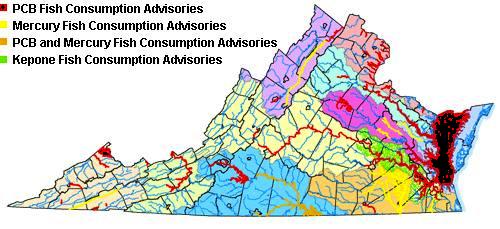
2 Background# CBF participation in Delisting and CAMR challenge# An issue for our members. Itʼs personal Quality of life and preserving the resource Experience with mercury contamination. Hair sampled.# Health advisories, impact on commercial and recreational fishing# Ø Maryland - Limit on rockfish# Ø Pennsylvania - Every river basin has an advisory# Ø Virginia - Advisories in pristine areas Mattaponi, Pamunkey, Piankatank, Dragon Run, Blackwater, Dismal Swamp #
3

4 York River Basin Bodies of water with fish consumption advisory due to Mercury:# # Lake Gordonsville# Pamunkey River# Mattaponi River# Herring Creek#

5 Pamunkey River #


6 Chesapeake Bay and Small Coastal Basin Region Bodies of water with fish consumption advisory due to Mercury:# # Lake Trashmore# Lake Whitehurst# Dragon Run Swamp# Piankatank River#

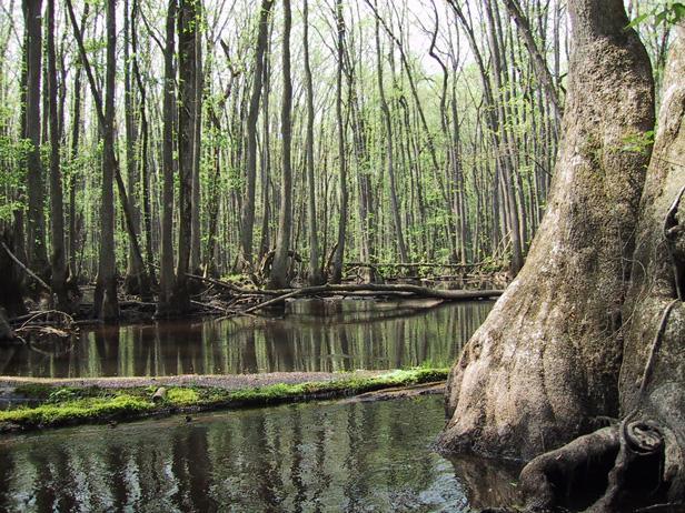
7 Dragon Run Swamp#

8 Bodies of water with fish consumption advisory due to Mercury:# # Blackwater River# Assamoosick Swamp# Nottoway River# Great Dismal Swamp, Lake Drummond# Chowan and Dismal Swamp River Basin
9 Blackwater River#

10 Lake Drummond#
11 Final Report for CHESAPEAKE BAY ANGLER INTERVIEWS IDENTIFYING POPULATIONS AT RISK FOR CONSUMING CONTAMINATED FISH IN THREE REGIONS OF CONCERN CMI-HDD Submitted: March 29, 2005 Prepared for the Chesapeake Bay Program Prepared by: Joshua C. Gibson & Julie A. McClafferty Human Dimensions Division Conservation Management Institute College of Natural Resources Virginia Polytechnic Institute and State University 1900 Kraft Drive, Suite 250 (MS 0534) Blacksburg, VA (540)

12 1 Fletcher s Boat House 2 Theodore Roosevelt Island 3 Lady Bird Johnson Park/Columbia Island Marina 4 Gravelly Point/Roaches Run 5 East Potomac Park/Haines Point 6 Monument Tidal Basin 7 Water Street Marina Area 8 Dangerfield Island/Washington Sailing Marina 9 Anacostia Park South

13 1 Denbigh Park 2 Huntington Park Boat Ramp 3 James River Bridge Fishing Pier 4 Peterson Yacht Basin/Anderson Park 5 Jones Creek Boat Ramp 6 Haven Creek Boat Ramp/Lafayette City Park 7 Elizabeth City Boat Landing and Park 8 Portsmouth City Park 9 Great Bridge Lock Park


14 Modeling the Fate and Transport of Atmospheric Mercury in the Chesapeake Bay Region Dr. Mark Cohen NOAA Air Resources Laboratory Silver Spring, Maryland Presentation at NOAA Chesapeake Bay Office May 17, 2004, Annapolis MD
15 Emissions and Direct Deposition Contributions from Different Distance Ranges Away From the Chesapeake Bay# 80 8 Emissions (metric tons/year) Emissions Deposition Flux Deposition Flux (ug/m2-year) > Distance Range from Chesapeake Bay (km)
16 Largest Local Individual Sources Contributing to 1999 Mercury Deposition Directly to the Chesapeake Bay
17 Deposition to the Chesapeake Bay and to its Watershed (~1999) (linear graph) municipal waste incin medical waste incin haz waste incin other waste incin metallurgical cement/concrete chloralkali chemical manufacturing other manufacturing mobile sources coal-fired elec gen oil combustion (non-mobile) all other fuel combustion Atmospheric Mercury Deposition (kg Hg/yr) to Bay surface to Watershed

18 Sources Modeled#
19 Bay Watershed on Grid Scale# Chesapeake Bay Watershed J I
20 Hg Deposition (g/km2-yr): All Six VA Sources J I
21 Source Area in which Annual Mercury Deposition Rate Was Exceeded (km2) Rate: 0.1 g/km2 0.5 g/km2 1.0 g/km2 Bremo Bluff 37,260 3, Chesapeake 58,400 5,430 1,380 Clinch River 40,010 4,620 1,540 Glen Lyn 25,270 2, Jewell Coke 31,590 4,620 1,860 Potomac River 27,140 1, Table 2. Mercury Deposition Exceedance Area
22 Source Total Annual Deposition (lbs) Total Mercury Hg(0) RGM Hg(p) Bremo Bluff Chesapeake Clinch River Glen Lyn Jewell Coke Potomac River All 6 VA sources Table 3. Annual Deposition of Mercury to the Chesapeake Bay Watershed
23 Sensitive Receptors; Pamunkey River Basin (PRB), Dragon Run Watershed (DRW), and Great Dismal Swamp NWR (GDS) Sensitive Watershed Receptors J I
24 Source Total Annual Deposition (g) Total Mercury Hg(0) RGM Hg(p) Bremo Bluff Chesapeake Clinch River Glen Lyn Jewell Coke Potomac River All 6 VA sources Table 6. Annual Deposition of Mercury within the Pamunkey River Basin
25 Source Total Annual Deposition (g) Total Mercury Hg(0) RGM Hg(p) Bremo Bluff Chesapeake Clinch River Glen Lyn Jewell Coke Potomac River All 6 VA sources Table 7. Annual Deposition of Mercury within the Dragon Run Watershed
26 Source Total Annual Deposition (g) Total Mercury Hg(0) RGM Hg(p) Bremo Bluff Chesapeake Clinch River Glen Lyn Jewell Coke Potomac River All 6 VA sources Table 8. Annual Deposition of Mercury within the Great Dismal Swamp NWR
27 Litigation# February 2008, the DC Circuit struck down the delisting decision and CAMR EPA used Queen of Hearts logic December Citizens filed suit alleging EPA had failed to issue MACT standards by 2002 in violation of Section 112(d) of the CAA American Nurses Assoc, et al. v. EPA Consent Decree proposed. Challenged by industry. April 2010 Consent Decree entered. EPA had until November 2011 to promulgate rule. Extension to December 16. In October 2011, industry sought to amend the judgment (CD). Denied. MATS rule issued in February Industry challenges filed White Stallion Energy Center LLC v. EPA; UARG v. EPA. Environmental and Public Health Groups have moved to intervene.
28

29

30
NAVIGABLE WATERS OF THE UNITED STATES (Section 10 of the Rivers and Harbors Act)
") NAVIGABLE WATERS OF THE UNITED STATES (Section 10 of the Rivers and Harbors Act) Revised March 5, 2010: It amends the old list to address certain waterways that are known to support interstate commerce
NAVIGABLE WATERS OF THE UNITED STATES (Section 10 of the Rivers and Harbors Act) Revised March 5, 2010: It amends the old list to address certain waterways that are known to support interstate commerce
Critical Habitat for Atlantic Sturgeon
 Critical Habitat for Atlantic Sturgeon GARFO Presentation to the Chesapeake Bay Sustainable Fisheries Goal Implementation Team September 22, 2017 Julie Crocker NMFS GAR Protected Resources This Presentation
Distribution of the Atlantic Bottlenose Dolphin (Tursiops truncatus) in the Chesapeake Bay Drainage in Virginia
 in the Chesapeake Bay Drainage in Virginia") Banisteria, Number 11, 1998 33 1998 by the Virginia Natural History Society Distribution of the Atlantic Bottlenose Dolphin (Tursiops truncatus) in the Chesapeake Bay Drainage in Virginia Thomas F. Wilcox
Banisteria, Number 11, 1998 33 1998 by the Virginia Natural History Society Distribution of the Atlantic Bottlenose Dolphin (Tursiops truncatus) in the Chesapeake Bay Drainage in Virginia Thomas F. Wilcox
ELIZABETH RIVER FACTS
 ELIZABETH RIVER FACTS How is she different from inland rivers? The Elizabeth River is an estuary a tidal finger of the Chesapeake Bay, rather than a freshwater river with a spring as origin. The Elizabeth
Three point plan to addressing land use and habitat loss impacts on Chesapeake Bay tidal fish and shellfish
 Three point plan to addressing land use and habitat loss impacts on Chesapeake Bay tidal fish and shellfish 1. Establish Principles for Protection of Chesapeake Bay Fish and Shellfish The Fisheries GIT
Sea Kayaking Maryland'S Chesapeake Bay
 Sea Kayaking Maryland'S Chesapeake Bay If you are searching for a book Sea Kayaking Maryland'S Chesapeake Bay in pdf format, then you have come on to faithful site. We presented the complete variant of
LEARN MORE OUR RESEARCH QUESTIONS WHAT WE DID THIS BROCHURE. GRAND LAKE WATERSHED MERCURY STUDY Our study website
 LEARN MORE GRAND LAKE WATERSHED MERCURY STUDY Our study website http://www.grandlakemercurystudy.org KS OK GRAND LAKE Grand Lake watershed What s in your fish? fact sheet http://www.grandlakemercurystudy.org/whats_in_your_fish.pdf
This is America: The Potomac River Flows Through Cities, History
 This is America: The Potomac River Flows Through Cities, History Today we tell about the Potomac River. The Potomac is one of America s most historic waterways. It flows more than 600 kilometers, from
Historical Trends of Polychlorinated Biphenyls in Chesapeake Bay Fish and the Influence of Ongoing Sources
 Historical Trends of Polychlorinated Biphenyls in Chesapeake Bay Fish and the Influence of Ongoing Sources Trevor Needham Dr. Upal Ghosh University of Maryland Baltimore County Background Data collected
Notice of Intent to Close Inactive CCR Surface Impoundments
 Notice of Intent to Close Inactive CCR Surface Impoundments Virginia Electric and Power Company Possum Point Power Station Coal Combustion Residual Surface Impoundments A, B, C, D, and E Dumfries, Virginia
Mercury in Fish from 21 National Parks in the Western U.S. and Alaska Inter- and Intra-park variation
 Mercury in Fish from 21 National Parks in the Western U.S. and Alaska Inter- and Intra-park variation NADP Fall Meeting October 23, 2014 Collin Eagles-Smith 1, James Willacker 1, and Colleen Flanagan Pritz
Chincoteague National Wildlife Refuge and Wallops Island National Wildlife
 This document is scheduled to be published in the Federal Register on 09/11/2015 and available online at http://federalregister.gov/a/2015-21925, and on FDsys.gov Billing Code 4310-55 DEPARTMENT OF THE
Emergency Action on Regulations
 MARYLAND REGISTER Emergency Action on Regulations TO BE COMPLETED BY AELR COMMITTEE Date Received by AELR Committee 04/09/2018 Emergency Status Approved X-Yes _-No Emergency Status Begins On 5/3/2018 Emergency
Request for Proposals L4865 The Pier 25 Marine Facility Concession at Hudson River Park (RFP) Sub- concessionaires Letters of Interest
 Sub- concessionaires Letters of Interest") Request for Proposals L4865 The Pier 25 Marine Facility Concession at Hudson River Park (RFP) Sub- concessionaires Letters of Interest January 8, 2018 To maximize the use of the Pier 25 Marine Facility,
Request for Proposals L4865 The Pier 25 Marine Facility Concession at Hudson River Park (RFP) Sub- concessionaires Letters of Interest January 8, 2018 To maximize the use of the Pier 25 Marine Facility,
The Sierra Fund Science Director Carrie Monohan, Ph.D.
 The Sierra Fund Science Director Carrie Monohan, Ph.D. Mercury and the Gold Rush USGS Fact Sheet 2005-3014 Mercury and the Gold Rush Mercury was used during hardrock and hydraulic mining. It is still entrained
The Chesapeake Bay as an Estuary: An introduction. Istvan A. Urcuyo Gettysburg College
 The Chesapeake Bay as an Estuary: An introduction. Istvan A. Urcuyo Gettysburg College The Chesapeake Bay -Native Americans resided on its shores since 8000 B.C. The Chesapeake Bay -Original Native American
Update on the 2017 Atlantic Menhaden Fishing Season
 Update on the 2017 Atlantic Menhaden Fishing Season Sustainable Fisheries Branch NMFS Beaufort Laboratory Beaufort, NC GSMFC Spring Meeting Panama City, FL March 13, 2018 2017 Landings for Reduction One
SOCIETAL GOALS TO DETERMINE ECOSYSTEM HEALTH: A FISHERIES CASE STUDY IN GALVESTON BAY SYSTEM, TEXAS
 SOCIETAL GOALS TO DETERMINE ECOSYSTEM HEALTH: A FISHERIES CASE STUDY IN GALVESTON BAY SYSTEM, TEXAS Anthony S. Pait, NOAA, National Centers for Coastal Ocean Science Thomas P. O Connor, David R. Whitall,
Atlantic States Marine Fisheries Commission
 Atlantic States Marine Fisheries Commission 050 N. Highland Street Suite 00A-N Arlington, VA 0 703.84.0740 703.84.074 (fax) www.asmfc.org MEMORANDUM January 6, 05 TO: FROM: Atlantic Striped Bass Management
Public Notice U.S. Army Corps In Reply to Application Number CENAB-OP-RMS (NATIONAL HARBOR (FORMERLY PORT Baltimore District AMERICA])
![Public Notice U.S. Army Corps In Reply to Application Number CENAB-OP-RMS (NATIONAL HARBOR (FORMERLY PORT Baltimore District AMERICA])](/thumbs/89/100795623.jpg "Public Notice U.S. Army Corps In Reply to Application Number CENAB-OP-RMS (NATIONAL HARBOR (FORMERLY PORT Baltimore District AMERICA])") Public Notice U.S. Army Corps In Reply to Application Number of Engineers CENAB-OP-RMS (NATIONAL HARBOR (FORMERLY PORT Baltimore District AMERICA]) 88-01361 PN 14-05 Comment Period: January 16, 2014 to
Public Notice U.S. Army Corps In Reply to Application Number of Engineers CENAB-OP-RMS (NATIONAL HARBOR (FORMERLY PORT Baltimore District AMERICA]) 88-01361 PN 14-05 Comment Period: January 16, 2014 to
*Sandy Point State Park Paddling Routes
 *Sandy Point State Park Paddling Routes *Paddleboards are crazy popular in Anne Arundel County creeks and rivers. The life guards on this park s beaches have paddleboards to use in recusing swimmers. Not
Fish were collected in April September 2013 by the Fisheries and Wildlife Division staff at DOEE.
 Fish were collected in April September 2013 by the Fisheries and Wildlife Division staff at DOEE. US EPA Guidance for Assessing Chemical Contaminant Data for Use in Fish Advisories Volume 1: Fish Sampling
III BASIN DESCRIPTION
 III-1 III BASIN DESCRIPTION The Youghiogheny Basin covers 1768 sq mi and extends from northern Maryland to McKeesport, Pennsylvania. This report deals only with the 1,255 sq mi of the basin within Pennsylvania
W rking towards healthy rking
 Working towards healthy, self-sustaining sustaining populations for all Atlantic coast fish species or successful restoration well in progress by 2015 Terms of Reference Atlantic Striped Bass Management
2017 State of the Tidal Potomac River Largemouth Bass Fishery (Maryland) Joe Love
 Joe Love") 2017 State of the Tidal Potomac River Largemouth Bass Fishery (Maryland) Joe Love Joseph.love@maryland.gov 410-260-8257 1 Background Targeted Black Bass Surveys Markham et al. (2002); Love (2004) Standard
2017 State of the Tidal Potomac River Largemouth Bass Fishery (Maryland) Joe Love Joseph.love@maryland.gov 410-260-8257 1 Background Targeted Black Bass Surveys Markham et al. (2002); Love (2004) Standard
HARBOR INFRASTRUCTURE INVENTORIES Harbor Beach Harbor, Michigan
 HARBOR INFRASTRUCTURE INVENTORIES Harbor Beach Harbor, Michigan Harbor Location: Harbor Beach Harbor is located on the west shore of Lake Huron about 60 miles north of Port Huron, MI. Authority: Rivers
SUMMARY COSTS: (Please attach a detailed budget including all sources of recipient funding)
") VIRGINIA SALTWATER RECREATIONAL FISHING DEVELOPMENT FUND SUMMARY PROJECT APPLICATION Please complete all fields. This page should be used as a coversheet for a detailed application. NAME AND ADDRESS OF
VIRGINIA SALTWATER RECREATIONAL FISHING DEVELOPMENT FUND SUMMARY PROJECT APPLICATION Please complete all fields. This page should be used as a coversheet for a detailed application. NAME AND ADDRESS OF
Warm-up # 7 A day 5/17 - B day 5/18 UPDATE YOUR TABLE OF CONTENTS
 Warm-up # 7 A day 5/17 - B day 5/18 UPDATE YOUR TABLE OF CONTENTS Question: List all examples of surface water on Earth. Answer: Rivers and streams, lakes and reservoirs, (ponds) wetlands, estuaries and
Indian River Lagoon: Lessons, Challenges and Opportunities
 Indian River Lagoon: Lessons, Challenges and Opportunities Upper Chain of Lakes Lake Kissimmee Kissimmee River Indian River Lagoon Caloosahatchee Estuary Lake Okeechobee St. Lucie Estuary Mark Perry, Executive
Old Dominion Soccer League
 Old Dominion Soccer League New Club Application Instructions Old Dominion Soccer League New Club Admissions Committee P.O. Box 825 Gainesville, VA 20156 Revision History Date Version Author/Editor Comments
The 2010 BP Oil Disaster Pacific States Marine Fisheries Commission 63 rd Annual Meeting August 24, 2010
 The 2010 BP Oil Disaster Pacific States Marine Fisheries Commission 63 rd Annual Meeting August 24, 2010 Larry Simpson Gulf States Marine Fisheries Commission Oil Spill On April 20, 2010, the Deepwater
Cobourg Marina and West Harbour Headland
 Cobourg Marina and West Harbour Headland Marina Expansion When I imagine Cobourg s future waterfront I see The boat storage moved and a rewilding of West Beach Keeping what we have in pristine repaired
Good first day even if you did have to motor keep me posted I enjoy them
 Left HPYC at 12X12 this afternoon. Due to lack of wind we motored to Meredith Creek off of Whitehall bay just north of the Severn River. Anchored off of Carlton Mitchell's mansion. The entrance is fairly
RIVER HERRING PROGRAM
 RIVER HERRING PROGRAM River Herring NORTHEAST REGION Assessing Sustainability of River Herring Runs Department of Marine Resources Award Amount... $400,483 Grantee Match... $415,340 Total Project... $815,823
ARTICLE III. CERTAIN PUBLIC PLACES* DIVISION 1. GENERALLY DIVISION 2. MUNICIPAL YACHT BASIN DIVISION 3. MANAGED MOORING FIELD
 ARTICLE III. CERTAIN PUBLIC PLACES* *Cross References: Parks and recreation, Ch. 14. Secs. 17-56--17-65. Reserved. DIVISION 1. GENERALLY DIVISION 2. MUNICIPAL YACHT BASIN Sec. 17-66. Mooring. It shall
SONAR ESTIMATION OF ADULT STEELHEAD: VARIOUS METHODS TO ACCOUNT FOR KELTS IN DETERMINING TOTAL ESCAPEMENT
 SONAR ESTIMATION OF ADULT STEELHEAD: VARIOUS METHODS TO ACCOUNT FOR KELTS IN DETERMINING TOTAL ESCAPEMENT Michael D. Sparkman (CDFW) Fisheries Biologist North Coast Sonar Coordinator Coastal Steelhead
Integrated Pest Management Program Final Report
 Integrated Pest Management Program Final Report Shoreline Stewardship Program: Be a Lake Pan Pal Joan Bradshaw Specialized Regional Programs for Natural Resource Citrus, Hernando, Pasco and Sumter Counties
BAY-SIC RATIOS. W. A.V.E. BAY-SIC Ratios
 BAY-SIC RATIOS INTRODUCTION: The land that surrounds the Chesapeake Bay spans 64,000 square miles and includes portions of six states Virginia, West Virginia, Maryland, Pennsylvania, Delaware, and New
James River National Wildlife Refuge, Prince George County, VA; Final. Comprehensive Conservation Plan and Finding of No Significant Impact for
 This document is scheduled to be published in the Federal Register on 07/09/2015 and available online at http://federalregister.gov/a/2015-16764, and on FDsys.gov Billing Code 4310 55 DEPARTMENT OF THE
Potomac River Fisheries Commission s. American Shad Fishing / Recovery Plan. Submitted to the Atlantic States Marine Fisheries Commission
 Potomac River Fisheries Commission s American Shad Fishing / Recovery Plan Submitted to the Atlantic States Marine Fisheries Commission January 10, 2012 1. Sustainable Fishery Plan In accordance with the
13 August 14, 2013 Public Hearing
 13 August 14, 2013 Public Hearing APPLICANT/ PROPERTY OWNER: POCAHONTAS LANDING, L.L.C. STAFF PLANNER: Ray Odom REQUEST: Condition Use Permit (Non-Commercial Marina) ADDRESS / DESCRIPTION6: Terminus of
June NMFS Address 11, 2014 (NOAA): Council Address. Dover, DE 19901
: Council Address. Dover, DE 19901") BLACK SEA BASS SEASON OPENING FRAMEWORK ADJUSTMENT Discussion Document and Background June 2014 Mid-Atlantic Fishery Management Council in cooperation with the National Marine Fisheriess Service (NMFS)
BLACK SEA BASS SEASON OPENING FRAMEWORK ADJUSTMENT Discussion Document and Background June 2014 Mid-Atlantic Fishery Management Council in cooperation with the National Marine Fisheriess Service (NMFS)
2012 Maryland FMP Report (July 2013) Section 15. Red Drum (Sciaenops ocellatus)
 Section 15. Red Drum (Sciaenops ocellatus)") 1981 1983 1985 1987 1989 1991 1995 1997 1999 2001 2003 2005 2007 2009 2011 Pounds 2012 Maryland FMP Report (July 2013) Section 15. Red Drum (Sciaenops ocellatus) Chesapeake Bay FMP In 2012, red drum were
1981 1983 1985 1987 1989 1991 1995 1997 1999 2001 2003 2005 2007 2009 2011 Pounds 2012 Maryland FMP Report (July 2013) Section 15. Red Drum (Sciaenops ocellatus) Chesapeake Bay FMP In 2012, red drum were
Recreational Boating Feasibility and Capacity Study
 TOURISTICS + Shoreplan Engineering Limited were retained by: Town of Oakville; City of Burlington; and Regional Municipality of Halton. Note: Throughout the presentation boat lengths are identified in
Summer Kick-Off Party
 EXCITING ANNOUNCEMENTS Summer Kick-Off Party Saturday, June 16th, 11am - 3pm Page 1 Tickets to the event are FREE but please RSVP for head count. To RSVP, call the Front Office at 301-261-9500 or email
Chagrin River TMDL Appendices. Appendix F
 Appendix F The following are excerpts from the Eastern Brook Trout Joint Venture s Conservation Strategy (Working Draft v.6), Conserving the Eastern Brook Trout: Strategies for Action Found at: http://www.easternbrooktrout.org/constrategy.html
Atlantic States Marine Fisheries Commission An Overview. Tina Berger, Director of Communications
 Atlantic States Marine Fisheries Commission An Overview By Tina Berger, Director of Communications Presentation Overview Commission Overview ASMFC Programs Species Highlights American Eel Atlantic Menhaden
Potomac Fever. Captain Bill Washington. President, CAPCA
 Potomac Fever by Captain Bill Washington President, CAPCA Unlike most of you, I consider the Potomac River around Washington, DC, to be my primary cruising ground. As mundane as this may sound, the area
The Sierra Fund Carrie Monohan, Ph.D. Science Director
 The Sierra Fund Carrie Monohan, Ph.D. Science Director Mercury and the Gold Rush SOURCE: USGS Fact Sheet 2005-3014 Mercury and the Gold Rush Mercury was used during hard rock and hydraulic mining. It is
EXCITING UPDATES & ANNOUNCEMENTS. Maryland Oyster Gardening Program.
 EXCITING UPDATES & ANNOUNCEMENTS Newsletter Page 1 This week Harbour Cove Marina will be participating in the Maryland Oyster Gardening Program. We will have cages on the right hand side of C-Pier. Oysters
Fisheries Resources in White Pine County
 Fisheries Resources in White Pine County June 22, 2013 Update to the Nevada Board of Wildlife Commissioners Jon C. Sjöberg Chief of Fisheries Comins Lake Located 7 miles south of Ely. Built in 1953 as
BookletChart. Chesapeake Bay Severn and Magothy Rivers NOAA Chart A reduced-scale NOAA nautical chart for small boaters
 BookletChart Chesapeake Bay Severn and Magothy Rivers NOAA Chart 12282 A reduced-scale NOAA nautical chart for small boaters When possible, use the full-size NOAA chart for navigation. Published by the
MARCH /8 DAYLIGHT SAVINGS TIME BEGINS 3/8 Chowan River Bass Bash Chowan River Tunis Landing
 MARCH 2015 3/7 NAZBASS Yeopium River Bethel Fishing Ctr 3/7 ELIZABETH CITY BASS MASTERS Chowan River Cannon s Ferry 3/7 3/7 3/8 DAYLIGHT SAVINGS TIME BEGINS 3/8 Chowan River Bass Bash Chowan River Tunis
Order Adopting Amendments. Title 58. Recreation Part II. Fish and Boat Commission Chapters 97, 109, 111 and 115 Boating. Preamble
 Order Adopting Amendments COMMONWEALTH OF PENNSYLVANIA PENNSYLVANIA FISH AND BOAT COMMISSION Title 58. Recreation Part II. Fish and Boat Commission Chapters 97, 109, 111 and 115 Boating Preamble The Fish
2012 Maryland FMP Report (August 2013) Section 18. Summer Flounder (Paralichthys dentatus)
 Section 18. Summer Flounder (Paralichthys dentatus)") 2012 Maryland FMP Report (August 2013) Section 18. Summer Flounder (Paralichthys dentatus) Chesapeake Bay FMP States were granted greater management flexibility for the recreational summer flounder fishery
2012 Maryland FMP Report (August 2013) Section 18. Summer Flounder (Paralichthys dentatus) Chesapeake Bay FMP States were granted greater management flexibility for the recreational summer flounder fishery
2015 Maryland FMP Report (August 2016) Section 22. Yellow Perch (Perca flavescens)
 Section 22. Yellow Perch (Perca flavescens)") 2015 Maryland FMP Report (August 2016) Section 22. Yellow Perch (Perca flavescens) A commercial yellow perch pilot program began at the opening of the 2016 season with twenty eight participants. These
2015 Maryland FMP Report (August 2016) Section 22. Yellow Perch (Perca flavescens) A commercial yellow perch pilot program began at the opening of the 2016 season with twenty eight participants. These
Indiana Electricity Projections and Renewable Energy
 Indiana Electricity Projections and Renewable Energy Presented by: Douglas J. Gotham, Director State Utility Forecasting Group Purdue University Presented to: 2012 Energy & Water Education Conference Indianapolis,
Gouk s Excellent Adventures Part 2
 Gouk s Excellent Adventures Part 2 Taylor s Island Tuesday, October 11, 2016 Departed Georgetown Yacht Basin, Maryland at 7:15 a.m. and made a nice long day of it, arriving at Taylor's Island, Little Choptank
EXCITING UPDATES & ANNOUNCEMENTS NEW 2019 LEASES
 EXCITING UPDATES & ANNOUNCEMENTS Page 1 NEW 2019 LEASES Harbour Cove sent out leases last week. If you have not received your lease or are not planning to renew your lease, please contact Peter at mueller@harbourcove.com
2002 REVIEW OF THE ATLANTIC STATES MARINE FISHERIES COMMISSION FISHERY MANAGEMENT PLAN FOR BLUEFISH (Pomatomus saltatrix)
") 2002 REVIEW OF THE ATLANTIC STATES MARINE FISHERIES COMMISSION FISHERY MANAGEMENT PLAN FOR BLUEFISH (Pomatomus saltatrix) Prepared by: Michael Lewis (ASMFC) Bluefish Plan Review Team Elliot Atstupenas
2002 REVIEW OF THE ATLANTIC STATES MARINE FISHERIES COMMISSION FISHERY MANAGEMENT PLAN FOR BLUEFISH (Pomatomus saltatrix) Prepared by: Michael Lewis (ASMFC) Bluefish Plan Review Team Elliot Atstupenas
Accounting for Growth: Policy Implications for the Partnership
 Accounting for Growth: Policy Implications for the Partnership Chesapeake Bay Commission September 8, 2017 Rich Batiuk Associate Director for Science, Analysis and Implementation Chesapeake Bay Program
Sconser Quarry, Caol Mor
 Sconser Quarry, Caol Mor AUTODEPOMOD MODELLIN G REPORT 4.2017 Registered in Scotland No. 138843 Registered Office, 1st Floor, Admiralty Park, Admiralty Road, Rosyth, FIFE, KY11 2YW Marine Harvest ( Scotland)
Bathing Water Profile - Carne (2017)
") Bathing Water Profile - Carne (2017) Bathing Water: Bathing Water Code: Local Authority: River Basin District: Monitoring Point: Carne IESEBWC050_0000_0300 Wexford County Council South Eastern 312952E,
Bathing Water Profile - Carne (2017) Bathing Water: Bathing Water Code: Local Authority: River Basin District: Monitoring Point: Carne IESEBWC050_0000_0300 Wexford County Council South Eastern 312952E,
Forage Fish Outcome Management Strategy , v.1
 Management Strategy 2015 2025, v.1 I. Introduction Photo credit: Virginia Institute of Marine Science. Bay anchovy (Anchoa mitchilli). Forage species are an important component of the food web linking
North Carolina Aquaculture Plan for American Eel Management Board August 2 nd, 2017
 North Carolina Aquaculture Plan for 2018 American Eel Management Board August 2 nd, 2017 Background Outline NC Aquaculture Plan: 2017 season results NC Proposed Aquaculture Plan for 2018 and beyond Highlight
NOAA Marine Debris Program
 NOAA Marine Debris Program Nancy Wallace National Oceanic and Atmospheric Administration Marine Debris Program Spill Control Association of America Annual Meeting March 2019 1 NOAA Marine Debris Program
2001 REVIEW OF THE ATLANTIC STATES MARINE FISHERIES COMMISSION FISHERY MANAGEMENT PLAN FOR WEAKFISH (Cynoscion regalis)
") 2001 REVIEW OF THE ATLANTIC STATES MARINE FISHERIES COMMISSION FISHERY MANAGEMENT PLAN FOR WEAKFISH (Cynoscion regalis) Plan Review Team Rick Cole, DE Louis Daniel, NC Charles Lesser, DE Rob O Reilly,
2001 REVIEW OF THE ATLANTIC STATES MARINE FISHERIES COMMISSION FISHERY MANAGEMENT PLAN FOR WEAKFISH (Cynoscion regalis) Plan Review Team Rick Cole, DE Louis Daniel, NC Charles Lesser, DE Rob O Reilly,
Mill Creek/Rose Valley Watershed General Information Presented by Dr. Mel Zimmerman Lycoming College CWI
 Mill Creek/Rose Valley Watershed General Information Watershed Concerns Rose Valley Lake Areas of Interest Biodiversity of Interest in Rose Valley Lake Rose Valley Lake Bird Area Fishes of Rose Valley
Introduction and Background
 Figure 1: The increase in American shad in the Potomac River. The blue line is the Atlantic States Marine Fisheries Commission s restoration target, a running geometric mean of 31.1pounds/net-day caught
Managing Development and Chesapeake Bay s Estuarine Fish
 Managing Development and Chesapeake Bay s Estuarine Fish Habitat Image and or Graphic Fisheries James H. Uphoff Jr. and Margaret M. McGinty Maryland Fisheries Service Funded through USFWS Federal Aid Maryland
Chapter 5: Survey Reports
 Manual of Fisheries Survey Methods II: with periodic updates : Survey Reports James C. Schneider and J. W. Merna Suggested citation: Schneider, James C. and J. W. Merna. 2000. Survey reports. in Schneider,
PERFORMANCE ANALYSIS of The Draft 2015 CLRP
 Item 9 PERFORMANCE ANALYSIS of The Draft CLRP Presentation to the Transportation Planning Board September 16, CLRP Performance Analysis 1 What is the Long-Range Transportation Plan (CLRP)? The CLRP identifies
As directed last month, I ve placed the matter back on your agenda for further discussion.
 SOUTHAMPTON COUNTY BOARD OF SUPERVISORS Regular Session i July 25, 2016 14. CONTINUED DISCUSSION EXPANSION OF NO-WAKE ZONES As you know, following the close of last month s public hearing, the Board took
Chesapeake Bay Jurisdictions White Paper on Draft Addendum IV for the Striped Bass Fishery Management Plan
 Chesapeake Bay Jurisdictions White Paper on Draft Addendum IV for the Striped Bass Fishery Management Plan Maryland Department of Natural Resources, District of Columbia s Fisheries and Wildlife Division,
HARBOR INFRASTRUCTURE INVENTORIES Lorain Harbor, Ohio
 HARBOR INFRASTRUCTURE INVENTORIES Lorain Harbor, Ohio Harbor Location: Lorain Harbor is located on the southern shore of Lake Erie in the city of Lorain, OH about 45 miles west of Cleveland, OH. Authority:
TENTATIVE AGENDA MARINE RESOURCES COMMISSION MARCH 29, 2011
 TENTATIVE AGENDA MARINE RESOURCES COMMISSION MARCH 29, 2011 ** APPROVAL OF AGENDA. 1. MINUTES of previous meeting. 2. PERMITS (Projects over $50,000 with no objections and with staff recommendation for
Hudson River Fish Advisory Outreach Project. PCB Forum at Marist College January 16, 2013
 Hudson River Fish Advisory Outreach Project PCB Forum at Marist College January 16, 2013 1 Hudson River Fish Advisory Outreach Project What is a fish advisory? What is the health advice about eating Hudson
AUDIT U.S. FISH AND WILDLIFE SERVICE WILDLIFE AND SPORT FISH RESTORATION PROGRAM GRANTS
 AUDIT U.S. FISH AND WILDLIFE SERVICE WILDLIFE AND SPORT FISH RESTORATION PROGRAM GRANTS Awarded to the State of Wisconsin, Department of Natural Resources, From July 1, 2007, Through June 30, 2009 Report
Florida Keys National Marine Sanctuary
 Florida Keys National Marine Sanctuary Review of the Marine Zones and Regulations [insert your name here] [insert your email here] Florida Keys National Marine Sanctuary 2900 nm 2 / 10,000 km 2 Jurisdiction
1 Overview. Pressure Measurement Transmitters for basic requirements. 1/16 Siemens FI SITRANS P220 for gauge pressure
 Siemens AG 204 Overview The pressure transmitter SITRANS P220 measures the gauge pressure of liquids, gases and vapors. Stainless steel measuring cell, fully welded Measuring ranges 2.5 to 600 bar (36.3
Potential Solutions for Mercury Control in the Cement Industry Portland Cement Association Meeting
 Potential Solutions for Mercury Control in the Cement Industry Portland Cement Association Meeting August 24, 2009 Agenda Albemarle Sorbent Technologies Quick Overview Mercury Sorbents Control Options
Collaborative. City of Stuart. September 7, Mark Perry, Executive Director Oceanographic Society. Upper Chain of Lakes
 Lake Okeechobee Collaborative Upper Chain of Lakes Lake Kissimmee Indian River Lagoon City of Stuart September 7, 2016 Kissimmee River Caloosahatchee Estuary Lake Okeechobee St. Lucie Estuary Everglades
GLOBALFOUNDRIES U.S. INC. Air Dispersion Modeling - FAB 8 Campus C.T. Male Project No.:
 C.T. Male Associates GLOBALFOUNDRIES U.S. INC. Air Dispersion Modeling - FAB 8 Campus C.T. Male Project No.: 11.1114 AIR DISPERSION MODELING RESULTS COMPARISON TO NATIONAL AMBIENT AIR QUALITY STANDARDS
Restoring the Iconicc Lower Cache River
 Restoring the Iconicc Lower Cache River A new chapter holds promise of revitalizing cherished waters and woods The story of conservation in the lower Cache River and surrounding Big Woods of eastern Arkansas
Alberta Conservation Association 2018/19 Project Summary Report. Primary ACA staff on project: Tahra Haddouche, Nikita Lebedynski, and Caitlin Martin
 Alberta Conservation Association 2018/19 Project Summary Report Project Name: Wapiti River Angler Survey Fisheries Program Manager: Peter Aku Project Leader: Nikita Lebedynski Primary ACA staff on project:
2000 REVIEW OF THE ATLANTIC STATES MARINE FISHERIES COMMISSION FISHERY MANAGEMENT PLAN FOR BLUEFISH (Pomatomus saltatrix)
") 2000 REVIEW OF THE ATLANTIC STATES MARINE FISHERIES COMMISSION FISHERY MANAGEMENT PLAN FOR BLUEFISH (Pomatomus saltatrix) Prepared by: Robert Beal (ASMFC) Bluefish Plan Review Team Elliot Atstupenas (USFWS)
2000 REVIEW OF THE ATLANTIC STATES MARINE FISHERIES COMMISSION FISHERY MANAGEMENT PLAN FOR BLUEFISH (Pomatomus saltatrix) Prepared by: Robert Beal (ASMFC) Bluefish Plan Review Team Elliot Atstupenas (USFWS)
COAL COMBUSTION RESIDUALS (CCR) FUGITIVE DUST CONTROL PLAN SANDY CREEK ENERGY STATION RIESEL, TEXAS. Prepared for:
 FUGITIVE DUST CONTROL PLAN SANDY CREEK ENERGY STATION RIESEL, TEXAS. Prepared for:") COAL COMBUSTION RESIDUALS (CCR) FUGITIVE DUST CONTROL PLAN SANDY CREEK ENERGY STATION RIESEL, TEXAS Prepared for: SANDY CREEK SERVICES, LLC P.O. Box 370 Riesel, Texas 76682 Prepared by: SCS ENGINEERS TBPE
COAL COMBUSTION RESIDUALS (CCR) FUGITIVE DUST CONTROL PLAN SANDY CREEK ENERGY STATION RIESEL, TEXAS Prepared for: SANDY CREEK SERVICES, LLC P.O. Box 370 Riesel, Texas 76682 Prepared by: SCS ENGINEERS TBPE
Potomac River Watershed Forum National Park Service Engagement Along the Tidal Potomac River Northern Neck Virginia
 Potomac River Watershed Forum National Park Service Engagement Along the Tidal Potomac River Northern Neck Virginia Overview The National Park Service is interested in engaging with partners to support:
Dissecting data. Amanda Bromilow Virginia Institute of Marine Science. Grade Level Middle School. Subject area Life, Environmental, or Marine Science
 Dissecting data Amanda Bromilow Virginia Institute of Marine Science Grade Level Middle School Subject area Life, Environmental, or Marine Science This work is sponsored by the National Estuarine Research
Hamilton Public Health Services 2014 Beach Monitoring Report
 Public Health Services Health Protection Division 110 King Street West, 2nd Floor, Hamilton, ON L8P 4S6 Phone: (905) 546-2424, ext. 3570 Fax: (905) 546-2787 Hamilton Public Health Services 2014 Beach Monitoring
Are human consumers potentially at risk from toxic chemicals in Casco Bay fish and shellfish?
 8 Are human consumers potentially at risk from toxic chemicals in Casco Bay fish and shellfish? Background Through the process of bioaccumulation (see Chapter 1) toxic metals and organic chemicals present
ALABAMA RIVER. Clarke County. Monroe County. Monroe County. Clarke County. CHART NO. 11 1, ,000 2,000 3,000 4,000 Feet RIVER MILE
 MILE 75 BAR 75 74 73 Isaac Creek Isaac Creek Campground Boat Ramp Claiborne Lock & Dam Water Outfall CLAIBORNE LOCK UA Claiborne Damsite West (232.4 Acres) Claiborne Damsite East (717.7 Acres) 72 Claiborne
February Check out our New Club Crest!! Please don t forget to visit or web site at: TABLE OF CONTENTS
 February 2010 Virginiabeachanglersclub.org vbanglersclub@yahoo.com Tight Virginia Beach Anglers Lines Club Check out our New Club Crest!! The Virginia Beach Anglers Club meets the first Thursday of each
Waterfront User Needs Assessment & Detailed Design RESPONSE TO COMMENTS
 Waterfront User Needs Assessment & Detailed Design RESPONSE TO COMMENTS Town of Cobourg Presentation to Council Monday July 3, 2018 4 PM 1 Response topics Opportunity to clarify and correct misinterpretations
Survival in an Estuary. Life in a Transition Zone
 Estuary An estuary is a semi-enclosed coastal body of water which has a free connection with the open sea and within which sea water is measurably diluted with fresh water derived from land drainage. (D.
For leasing information, contact: Andy Corno Thomas Jackman
 For leasing information, contact: Andy Corno andy.corno@am.jll.com 202-719-6137 Thomas Jackman thomas.jackman@am.jll.com 202-719-5624 This building has taken its place in history, now it s your turn. 600
Kerr Lake Vegetation Survey. October November Report submitted by NC State University. Background
 Kerr Lake Vegetation Survey October November 2012 Report submitted by NC State University Background Hydrilla (Hydrilla verticillata) is a non-native invasive submersed aquatic plant. This plant was first
Mercury Outboard Dealer!
 EXCITING UPDATES & ANNOUNCEMENTS Page 1 Harbour Cove is now an official Mercury Outboard Dealer! Inside this issue: Announcements 2 Event Calendar 3 Oyster Fest 4 Fishing News 5 Pool Hours 6 New Slip Renters
Atlantic States Marine Fisheries Commission
 Atlantic States Marine Fisheries Commission 1050 N. Highland Street Suite 200A N Arlington, VA 22201 703.842.0740 703.842.0741 (fax) www.asmfc.org MEMORANDUM August 1, 2016 To: Atlantic Striped Bass Management
Information about the Walleye Stocking in Douglas Lake June 27, /09/2018
 Date: August 9, 2018 To: From: Subject: Douglas Lake Improvement Association members Holly Gedert, President, DLIA 2018 Walleye Stocking in Douglas Lake Douglas Lake Improvement Association (DLIA) likes