How can river-estuarine planktonic copepods survive river floods?
|
|
|
- Nickolas Harrell
- 5 years ago
- Views:
Transcription
1 How can river-estuarine planktonic copepods survive river floods? Hiroshi Ueda 1 *, Ayumi Terao 1, Masaru Tanaka 2, Manabu Hibino 2 and Md. Shahidul Islam 2 1 Center for Marine Environmental Studies, Ehime University, Bunkyo-cho 3, Matsuyama, Ehime , Japan and Graduate School of Agriculture, Kyoto University, Oiwake-cho, Kitashirakawa, Sakyo-ku, Kyoto , Japan Running head: River-estuarine copepods survive floods *Author to whom correspondence should be addressed. hueda@sci.ehime-u.ac.jp Present address: Aichi Fisheries Promotion Fund, Department of Sea-Farming, 1-3 Ichizenmatsu, Nakayama, Atsumi-cho, Aichi , Japan 1
2 ABSTRACT Distribution of brackish-water zooplankton was surveyed in the Chikugo River estuary, Japan, at 3-hour intervals for 24 hours, including several hours when the river was heavily flooded due to rainfall and discharge from an upstream dam. The populations of the dominant copepods Pseudodiaptomus inopinus and Sinocalanus sinensis were concentrated in the mixing zone of the salt wedge before river flooding. During the period of flooding, they were almost completely swept out from the river, but examination of water trapped by a sediment grab sampler revealed that adults of P. inopinus were aggregated immediately above the bottom of the submerged channel outside the river mouth. After the flood, aggregations of both species appeared again in the river together with the salt wedge, and the proportion of adults in the aggregations became significantly higher than before. These results suggest that immature copepodids suffer population losses through river flooding, but that the copepods can survive such flooding by means of both behavioral and reproductive mechanisms; that is, adult copepods maintain their position on the bottom of submerged channels outside the river mouth during a river flood and replace the population loss through reproduction after the flood. Channels outside river mouths are thus regarded as important topographic refuges for river-estuarine zooplankton to survive a flood. Key Words: copepods, estuary, river flood, submerged channel, survival 2
3 INTRODUCTION Some planktonic animals inhabiting the tidal reaches of rivers exhibit adaptive behaviors to maintain their position in the river against the residual tidal flow, i.e. long-term average flow. A well-documented behavior is tidal vertical migration (Haertel & Osterberg 1967; Cronin & Forward 1979; Wooldridge & Erasmus 1980; Hough & Naylor 1991; Morgan et al. 1997; Kimmerer et al. 1998). Plankters maintain their position in the tidal reaches by shifting the population lower in the water column on the ebb tide than on the flood tide. When a river is swollen due to heavy rainfall and water flow is much faster than usual, however, indigenous river-estuarine zooplankton will be swept out to sea in spite of such maintenance mechanisms. Because there have been no reported instances of river floods causing local extinction of estuarine zooplankton, it seems that these organisms succeed in surviving such natural events. There have been no studies to learn how river-estuarine zooplankton manage to do this. Possible ways to withstand river floods are to return quickly into the tidal reaches without significant population losses, to recover the population loss through subsequent reproduction, or both. The present study provides some data to demonstrate the mechanism actually employed. On 6-7 July 2001, we made a 24-hour plankton survey in the lower tidal reaches of the Chikugo River, Kyushu. The objective of the survey was to monitor the tide-related vertical migration of the dominant planktonic copepods. In the morning of 6 July, however, there was a heavy rain, which had begun the previous night. The water at the study site flowed seaward much faster than usual, especially for several hours from the late morning, because a dam 23 km up the river released water by fully opening its water gate at 9:10. We completed the survey despite the severe field conditions, but we failed to take adequate data for showing tidal vertical 3
4 migration because we could collect only a small number of copepods in the tidal reaches during the period of river flooding. Nonetheless, we could observe that copepods once swept out from the tidal reaches returned quickly after the episode of flooding. This paper describes the phenomenon and presents an answer to the question of how they can do it. METHODS The study site was the tidal reaches of the Chikugo River and the submerged channel outside the river mouth (Fig. 1). The bottom of the channel was about 3 m deeper than the surrounding intertidal mudflat. The dominant zooplankton species at the site in summer are two brackishwater calanoid copepods, Pseudodiaptomus inopinus Burckhardt and Sinocalanus sinensis (Poppe), which are known to occur usually in water with a salinity of less than 20 psu (Hibino 2000). Nine sets of zooplankton samplings were made at about 3-hour intervals from the flood tide in the morning of 6 July 2001 to the same tide of the following day. The high tides were at 9:39 and 22:39 on 6 July and the low tides were at 16:02 on 6 July and 4:36 on 7 July. The sunset on 6 July was at 19:32 and the sunrise was at 5:16 on 7 July. In each set, zooplankton was taken at 3 to 5 consecutive stations out of a total of 6 stations located along the river axis. Samplings were made in ascending order of station number except for the fifth set, in which samplings were done from St. 5 to St. 1, and the time to start each sampling set is presented in Fig. 2. At each station, water samples were taken from the surface and about 0.5 to 1 m above the bottom using a self-closing trap-type water sampler designed by Ueda & Yoshimura (1992), with the volume of the sampler enlarged to 12 L. Middepth water samples also were taken at one or two stations in the first three sampling sets. 4
5 The boat was left to drift during sampling at each station, without driving it against the water flow or anchoring it, in order to be able to deploy the sampler vertically in the water column. Copepods in 10 L of the water were collected by sieving through a 200-µm mesh cloth and fixing with 2% formalin solution on board the boat. Salinity, temperature, and turbidity were measured simultaneously with the water sampling at depth intervals of 2 m at 4 or 5 consecutive stations using a portable water quality meter (DKK-TOA Corp., Model WQC-22A). The time required to complete one sampling set was approximately hours, most of which was spent in moving between the stations. In addition to the samples collected by the water sampler, the water immediately above the bottom was collected together with bottom mud at three different sites, near St. 2 at 14:30 (between the third and fourth sets), St. 6 at 16:30 (just after the fourth set), and on the mudflat near St. 6 at 18:40 (after sampling at St. 5 in the fifth set), using an Ekman grab sampler (225 cm 2 in mouth area). To collect copepods, the water in the grab was sieved through a 200-µm mesh cloth on board the boat and the mud was sieved through the same cloth by adding water in the laboratory. Developmental stages of P. inopinus and S. sinensis copepods were distinguished and all copepods collected were counted under a microscope. RESULTS Environmental conditions of the site In the first sampling set in the morning of 6 July, the river was already swollen due to rainfall since the previous evening, but riverward water flow on the flood tide was still weakly observed. 5
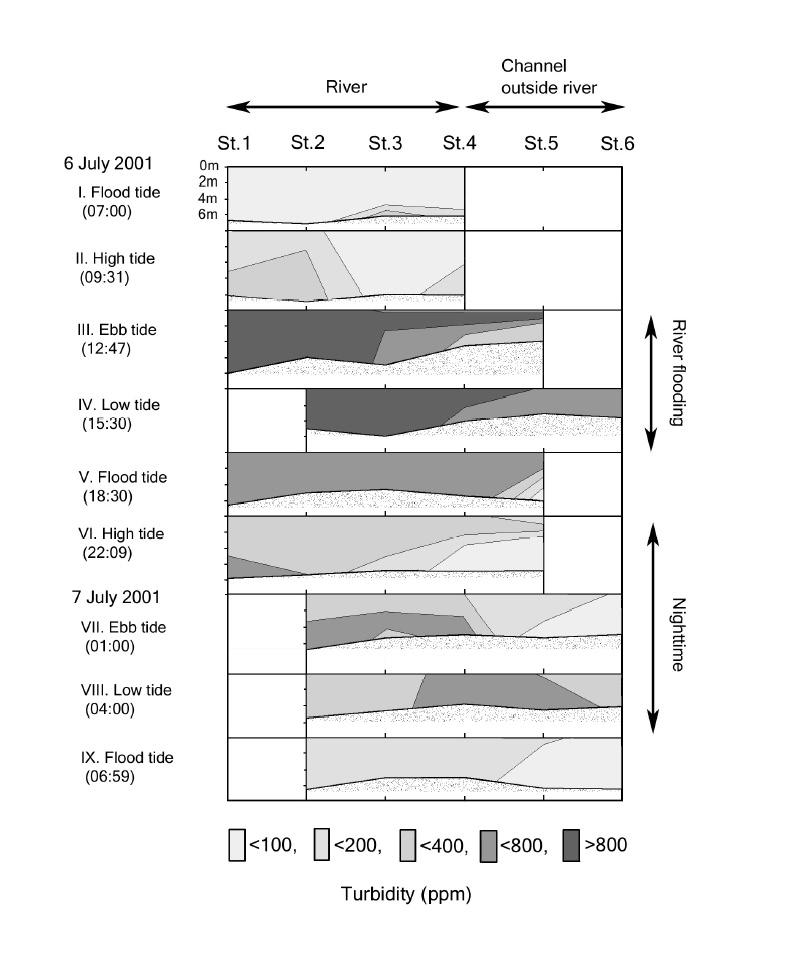
6 A distinct salt wedge was found in the river in the first and second sets (Fig. 2). The wedge did not move riverward from the first set on the flood tide to the second set on the high tide, indicating the rainfall had already strongly affected on the river flow at the second set. The water flow became much faster seaward a short time after the second set, which was apparently due to release of water from a dam upstream. The water in the entire study area was completely fresh in the third and fourth sets; under the usual conditions, a freshwater never reaches St. 4 even on a low tide (Shirota and Tanaka 1981). Henceforth we refer to the time of the third and fourth sets as the period of river flooding. In the evening, when the rain had almost stopped, a seaward surface-water flow was still observable in spite of the flood tide, but a salt wedge had appeared again in the channel outside the river mouth. This indicates that the saline bottom water was flowing as a countercurrent to the seaward surface-water flow. At the nighttime of 6 July, the surface water was still fresh even in the channel outside the river mouth, but the saline bottom water reached to a point between St. 2 and St. 3 in the river. The riverward tip of the mixing zone of the salt wedge moved about 7 km seaward, from St. 2 at high tide to St. 5 in the channel outside the river mouth at low tide at night. It returned into the river on the flood tide the next morning. The salt wedges at the fifth and ninth sets on the flooding tide lay much seaward than that at the first set on the same tide, This indicates that the effect of the river flood still considerably remained even at the ninth sampling set. Water temperature before the period of river flooding ranged from 25.8 C to 27.8 C and was higher in the bottom layer of the seaward stations. During the river flooding, the water was significantly cooler ( C) and no vertical difference was observed in either temperature or salinity, indicating strong turbulence caused by swift downward flow. Starting with the sixth 6
7 sampling set on the high tide, the temperature rose to C in the bottom layer in the channel outside the river mouth despite the nighttime cooling of the surface water. Turbidity greatly varied during the course of the survey (Fig. 3). The turbid bottom water (>200 ppm) at the riverward stations in the second sampling set is considered to have resulted from resuspension of bottom mud due to the swift water flow. The water in the river was extremely turbid (>800 ppm) during the period of river flooding, but less turbid water (<400 ppm) remained in the bottom layer of the channel outside the river mouth on the ebb tide. Turbidity of the mid- and surface water decreased gradually to <400 ppm on the high tide at night. Highly turbid freshwater remained near the salt wedge until the low tide of the next early morning. The water on the flood tide of 7 July was clearer than that at the preceding low tide but still more turbid than that on the same tide before the period of river flooding, indicating that the effect of river flooding persisted to the following day. Copepod distribution Pseudodiaptomus inopinus and Sinocalanus sinensis were equally abundant in the samples collected by the water sampler and their distributions in the estuary were similar to each other (Figs. 4 and 5). In the first sampling set, when both species were observed to aggregate in the mid-layer at St. 3 in the mixing zone of the salt wedge, a difference in distribution was seen between them at the more riverward stations (Sts. 1 and 2) with a salinity of less than 0.1 psu. There, S. sinensis was absent but P. inopinus was present at a density of 1.1 L -1. In the second set, they were again aggregated in the bottom layer of St. 3, with the highest abundances observed in the present survey (23.6 L -1 for P. inopinus and 16.3 L -1 for S. sinensis). During the period of river flooding, no P. inopinus were found in the samples collected by the water sampler, and only 7
8 1 (0.1 L -1 ) adult or late copepodid of S. sinensis appeared in each of the three water samples from the bottom layer at St. 2 on the ebb and low tides and the mid-layer at St. 3 on the low tide. A small number ( L -1 ) of copepods of both species occurred in the saline bottom-water from the flood tide in the evening through the ebb tide at midnight. On the next low tide, aggregations of both species were formed at the tip of the salt wedge in the channel outside the river mouth; their densities were comparable to those observed in the first sampling set. These aggregations moved to the river mouth with the salt wedge on the flood tide the next morning. The proportion of adults in these aggregations were significantly higher (58% in P. inopinus and 61% in S. sinensis) than those in the first sampling set (3% and 35%, respectively; p<0.001 for both species, test of the difference of the population ratios). The sex ratios of adult copepods in these aggregations were not extremely biased (female ratios in P. inopinus and in P. inopinus). Among the samples taken by the sediment grab sampler, the sample collected in the channel outside the river mouth (St.6) at 16:30, during the period of river flooding, contained 34 specimens of P. inopinus. These were all adult copepods and all were found in the trapped water except for one specimen in the mud sample. The volume of the trapped water was not measured but was clearly less than 1.5 L because the mud sample occupied more than half the capacity (3.3 L) of the sampler; therefore the density of the copepods in the trapped water was comparable to that in aggregations observed before the river flooding. One adult specimen of P. inopinus was also discovered in the trapped water of the sample taken near St. 2 at 14:30, but the sample from the mudflat near St. 6 at 18:40 on the flood tide contained no copepods. No specimen of S. sinensis was found in any grab sample. 8
9 DISCUSSION As far as we know, there have been no studies on the mechanism by which river-estuarine zooplankton survive river floods. One reason for the lack of such studies may be practical difficulties in monitoring zooplankton distribution in a flooded river. Especially, plankton sampling using a small boat in a rapidly flowing river is very risky. The original aim of our investigation was not to study the survival mechanism of the dominant copepods during floods, but to demonstrate a vertical migration and tidal current-related retention mechanism under normal conditions of the river estuary, as have been done by many other authors (e.g., Kimmerer et al. 1998). Accordingly the sampling scheme was not necessarily adequate to document all details of their survival mechanism. A major fault in the scheme was the location of the sampling stations, which did not cover the whole range of distribution of the object copepods Pseudodiaptomus inopinus and Sinocalanus sinensis; their populations were distributed much more seaward than we expected based on our previous studies in this estuary (Hibino 2000; Hibino et al. 1999). The present study is, however, providing important hints as to how they can survive river floods. Water sampling revealed that dense populations of both species were restricted to a single station situated in a mixing zone with a salinity of 5-20 psu, in contrast to much lower densities or absence of the copepods at the neighboring stations. The major part of the population was thus concentrated in the mixing zone of the salt wedge. During the period of river flooding, the water was fresh even at St. 6, the seaward end of the channel outside the river mouth, and no or very few copepods were captured in the water sampler. Instead, a number of P. inopinus were discovered in the water trapped by the sediment grab sampler at St. 6. These facts 9
10 indicate that the flood almost completely swept the populations of both copepods out of the river, but part of the P. inopinus population remained in an aggregation on the bottom of the submerged channel. This aggregation must have been confined to a very thin layer on the bottom since the copepods were absent in the bottom water sample taken m above the bottom at the same site just before the grab sample. Although the salinity in the bottom layer (about 1 m above the bottom) at St. 6 in the fourth sampling set was zero, the aggregation of P. inopinus in the grab sampler suggests that saline water remained on the bed of the channel during the period of river flooding. In general, saline water in the mixing zone of a river estuary would tend to be retained more on the bottom of channels outside the river mouth than in the bed of the river proper. This is because freshwater in the surface layer above the submerged deep channels would flow more slowly due to its spreading horizontally and in consequence vertical mixing of water would be weaker there than in the river. Weaker turbulence in the channel is also suggested by the fact that, on the ebb tide during the river flood, the water was less turbid on the bottom of the submerged channel outside than in the river itself. In addition, the freshwater covering the channel may keep copepods on the bed of the channel by preventing their upward migration (Grindley 1964). Copepods retained in the channel outside could return successfully to the river on the next flood tide. Thus, submerged channels outside a river mouth are regarded as important topographic refuges that allow river-estuarine zooplankton to survive floods. We did not discover any aggregation of S. sinensis during the period of river flooding. This species showed almost the same distribution pattern as P. inopinus in the estuary, but its distribution in the first sampling set somewhat differed from P. inopinus, that is, S. sinensis was absent at St. 1 and St. 2 where P. inopinus was present. This suggests that P. inopinus is more 10
11 tolerant of fresh- or extremely low saline water than S. sinensis and may account for the absence of S. sinensis at the point on the channel bed where P. inopinus aggregated. To evaluate population losses caused by river flooding, it is essential to consider organisms capacity for surviving such floods. The present results show that the populations of P. inopinus and S. sinensis in the Chikugo River estuary are usually concentrated in the mixing zone of the salt wedge. Copepod densities in the samples collected from these aggregations, however, do not necessarily provide good estimates of their population losses, because the densities no doubt vary greatly depending on the degree of concentration and the position in the aggregation. Instead, the stage composition of the copepod population could provide better information because this may not vary much with the degree of concentration or position in the aggregation. The aggregated copepods on the channel bed outside the river mouth during the period of river flooding were exclusively adults, indicating that adult copepods could maintain their position more successfully in the channel than immature copepodids, and therefore that the latter must suffer greater losses than the former. The proportion of immature copepodids in aggregations of P. inopinus dropped from 86% in the second sampling set to 42% in the ninth set, and those of S. sinensis were from 63% to 39 %. Assuming that adult copepods did not suffer population losses and the stage compositions were uniform in their aggregations, 76% and 94% losses of immature copepodids by P. inopinus and S. sinensis, respectively, are calculated from the deceases in the proportion of immature copepodids. These values imply that population losses due to river flooding were significant at least for immature copepodids, and accordingly, that the copepods would be forced to make up for these losses by reproduction after the flood. In conclusion, the present study indicates that the river-estuarine copepods in the Chikugo River estuary survive river floods by both behavioral and reproductive mechanisms; adult 11
12 copepods maintain their position on the bottom of submerged channels outside the river mouth during river floods, and they replace losses of immature copepodids through reproduction after the flood. ACNOWLEDGEMENTS We are grateful to Drs F.D. Ferrari, Smithsonian Institution, and M.J. Grygier, Lake Biwa Museum, for critical reading and improving of the manuscript, Messrs. K. Sakemi and S. Koga for driving the boat, and students of Kyoto University and Ehime University for field assistance. This work was supported by a grant of the Nissei Foundation to MT. REFERENCES Cronin T. W. & Forward R. B. Jr. (1979) Tidal vertical migrations: an endogenous rhythm in estuarine crab larvae. Science 205: Grindley J. R. (1964) Effects of low-salinity water on the vertical migration of estuarine plankton. Nature 203: Haertel L. & Osterberg C. (1967) Ecology of zooplankton, benthos and fishes in the Columbia River estuary. Ecology 48: Hibino M. (2000) [Early life history of Japanese temperate bass in the inner part of Ariake Sound: comparison between a surf zone and a river estuary]. MS thesis, Kyoto University, Kyoto, Japan. (In Japanese.) Hibino M., Ueda H. & Tanaka M. (1999) Feeding habits of Japanese temperate bass and copepod 12
13 community in the Chikugo River estuary, Ariake Sea, Japan. Nippon Suisan Gakkaishi 65: (in Japanese with English abstract.) Hough A. R. & Naylor E. (1991) Field studies on retention of the planktonic copepod Eurytemora affinis in a mixed estuary. Marine Ecology Progress Series 76: Kimmerer W. J., Burau J. R. & Bennett W. A. (1998) Tidally oriented vertical migration and position maintenance of zooplankton in a temperate estuary. Limnology and Oceanography 43: Morgan C. A., Cordel J. R. & Simenstad C. A. (1997) Sink or swim? Copepod population maintenance in the Columbia River estuarine turbidity-maxima region. Marine Biology 129: Shirota A. & Tanaka K. (1981) Studies on the suspended matter in the Ariake Bay - I. Transportation of the clay floc-suspension from the Chikugo River to the estuary. Bulletin of the Seikai Regional Fisheries Research Laboratory 56: (in Japanese with English abstract.) Ueda H. & Yoshimura M. (1992) Improved Patalas' self-closing water sampler - the easiest middepth use. Bulletin of Plankton Society of Japan 38: Wooldridge, T. & Erasmus, T. (1980) Utilization of tidal currents by estuarine zooplankton. Estuarine, Coastal and Shelf Science 11:
14 Figure legends Fig. 1. Map of the Chikugo River estuary with sampling stations. Broken lines show the extent of the intertidal mudflat outside the river mouth. Fig. 2. Salinity profiles in the Chikugo River estuary. Small circles indicate the sampling depths at each station. The depth of the bottom at each station varied depending on the tide and the position of the boat in the river when the measurement was done. The time in parentheses is the starting time for sampling at each tidal stage. Fig. 3. Turbidity profiles in the Chikugo River estuary. See Fig. 2 for further explanation. Fig. 4. Distribution of Pseudodiaptomus inopinus in the Chikugo River estuary before and after the period of river flooding on 6 July The letters S, M, and B represent surface, middepth, and bottom layers, respectively, which are shown in Fig. 2. The length of each horizontal bar represents the cumulative number of copepods per liter: early copepodids (CI- CIII, white bar), late copepodids (CIV-CV, grey bar), and adults (black bar). Fig. 5. Distribution of Sinocalanus sinensis in the Chikugo River estuary before and after the period of river flooding on 6 July See Fig. 4 for further explanation.
15
16
17
18
19
Zooplankton Migration Patterns at Scotton Landing: Behavioral Adaptations written by Lauren Zodl, University of Delaware
 Zooplankton Migration Patterns at Scotton Landing: Behavioral Adaptations written by Lauren Zodl, University of Delaware Summary: Zooplankton have evolved specific migration patterns that increase their
Co-Principal Investigators Stephen C. Jewett, Ph.D. Paul C. Rusanowski, Ph.D.
 PROGRESS REPORT FACTORS AFFECTING NEARSHORE SURVIVAL AND PRODUCTION OF JUVENILE SOCKEYE SALMON FROM KVICHAK BAY Phase I: Important habitat, migration routes and food resources CoPrincipal Investigators
Warm-up # 7 A day 5/17 - B day 5/18 UPDATE YOUR TABLE OF CONTENTS
 Warm-up # 7 A day 5/17 - B day 5/18 UPDATE YOUR TABLE OF CONTENTS Question: List all examples of surface water on Earth. Answer: Rivers and streams, lakes and reservoirs, (ponds) wetlands, estuaries and
What is an Estuary? Importance of Estuaries. Importance of Estuaries. Importance of Estuaries
 Oceanography 101, Richard Strickland Lecture 20 What is an Estuary? Portion of the ocean that is semi-enclosed by land and diluted by freshwater runoff All estuaries are embayments But embayments without
CHAPTER 11.1 THE WORLD OCEAN MARINE BIOMES NOTES
 CHAPTER 11.1 THE WORLD OCEAN MARINE BIOMES NOTES 1. The world ocean can be divided into zones both and. The,, and zones that apply to large lakes also apply to the ocean. 2. In addition to the depth zones,
SOME WATER CHARACTERISTICS OF ESTUARIES IN INDONESIA
 SOME WATER CHARACTERISTICS OF ESTUARIES IN INDONESIA by HENK L. UKTOLSEYA 1 ABSTRACT This paper describes the results obtained during several hydro-oceanographical observations of some estuaries in Indonesia
Ocean Current Worksheet
 Ocean Current Worksheet Temperature Affects and Surface Currents: Surface waters of the Earth s oceans are forced to move, primarily by winds. Where winds blow in the same direction for a long period of
10.6 The Dynamics of Drainage Flows Developed on a Low Angle Slope in a Large Valley Sharon Zhong 1 and C. David Whiteman 2
 10.6 The Dynamics of Drainage Flows Developed on a Low Angle Slope in a Large Valley Sharon Zhong 1 and C. David Whiteman 2 1Department of Geosciences, University of Houston, Houston, TX 2Pacific Northwest
-2- A. schlegeli and A. latus inhabit Hiroshima Bay. Although the former is abundant, the
 estimated TL has about a ± 5% error in the actual TL (Shigeta, unpubl. data). The water temperature and the salinity at the site of the observation were measured by a T-S and DO meter ( YSI Model 85, YSI
Cove Point Beach Restoration: Utilization of a Spawning Habitat by Horseshoe Crabs (Limulus polyphemus)
") Cove Point Beach Restoration: Utilization of a Spawning Habitat by Horseshoe Crabs (Limulus polyphemus) Paul Bushmann, Jessica Peterson, Bethany Enyeart and Deborah Smith Anne Arundel Community College
Cove Point Beach Restoration: Utilization of a Spawning Habitat by Horseshoe Crabs (Limulus polyphemus) Paul Bushmann, Jessica Peterson, Bethany Enyeart and Deborah Smith Anne Arundel Community College
Adaptations of Flora and Fauna in Rhode Island s s Estuaries
 Adaptations of Flora and Fauna in Rhode Island s s Estuaries Presented by: Kimberly Sullivan RIDEM Division of Fish and Wildlife Estuarine Habitats One of the most biologically diverse habitats in the
Juvenile Salmon Use of Knik Arm Estuaries. Hannah N. Ramage
 Juvenile Salmon Use of Knik Arm Estuaries Hannah N. Ramage Literature Review Function of estuaries for juvenile salmon Migration pathway Pink salmon use estuaries as a neutral pathway (Simenstad 1982)
Thermohaline Front at the Mouth of Ise Bay
 Journal of Oceanography, Vol. 53, pp. 403 to 409. 1997 Short Contribution Thermohaline Front at the Mouth of Ise Bay TETSUO YANAGI 1, XINYU GUO 1, TOSHIRO SAINO 2, TAKASHI ISHIMARU 3 and SINICHIRO NORIKI
Atsuko YAMAGUCHI. Since the catches of these fish decrease as the waters, including those around western Kyushu and
 Atsuko YAMAGUCHI distributions, feeding habits, reproductive behavior, off the coast of Nagasaki, western Kyushu. It is growth, migration, population structure, and other relatively large biological aspects
System of Plankton Database Opening to the Public in Lake Biwa
 Sengupta, M. and Dalwani, R. (Editors). 2008 Proceedings of Taal2007: The 12 th World Lake Conference: 597-602 System of Plankton Database Opening to the Public in Lake Biwa Satoshi Ichise,Tetsuya Wakabayashi,
7.4 Temperature, Salinity and Currents in Jamaica Bay
 7.4 Temperature, Salinity and Currents in Jamaica Bay Arnold Gordon, Bruce Huber and Robert Houghton 7.4.1 INTRODUCTION Jamaica Bay stratification is weakly indicative of a shallow, tidally active environment,
Chapter 10 Lecture Outline. The Restless Oceans
 Chapter 10 Lecture Outline The Restless Oceans Focus Question 10.1 How does the Coriolis effect influence ocean currents? The Ocean s Surface Circulation Ocean currents Masses of water that flow from one
Factors influencing production
 Fisheries Reading: Miller Ch. 15 Supplementary: Levinton, Ch. 18 Krkošek et al. Epizootics of wild fish induced by farm fish. Proceedings of the National Academy of Sciences (2006) vol. 103 (42) pp. 15506
Title: SYSTEM OF PLANKTON DATABASE OPENING TO THE PUBLIC IN LAKE BIWA. Satoshi ICHISE*,Tetsuya WAKABAYASHI*, Kenji YAMASHITA*and Shigeru AOKI*
 Title: SYSTEM OF PLANKTON DATABASE OPENING TO THE PUBLIC IN LAKE BIWA Satoshi ICHISE*,Tetsuya WAKABAYASHI*, Kenji YAMASHITA*and Shigeru AOKI* *Shiga prefectural Lake Biwa Environmental Research Institute
LIFE CYCLE AND COMMUNITY STRUCTURE OF CADDISFLIES (INSECTA:TRICHOPTERA) IN THE NAVASOTA RIVER, TEXAS.
 IN THE NAVASOTA RIVER, TEXAS.") LIFE CYCLE AND COMMUNITY STRUCTURE OF CADDISFLIES (INSECTA:TRICHOPTERA) IN THE NAVASOTA RIVER, TEXAS. An Undergraduate Research Scholars Thesis by SARAH PRUSKI Submitted to Honors and Undergraduate Research
LIFE CYCLE AND COMMUNITY STRUCTURE OF CADDISFLIES (INSECTA:TRICHOPTERA) IN THE NAVASOTA RIVER, TEXAS. An Undergraduate Research Scholars Thesis by SARAH PRUSKI Submitted to Honors and Undergraduate Research
Biotic vs. physical control of zooplankton in estuaries. Wim Kimmerer Romberg Tiburon Center for Environmental Studies San Francisco State University
 Biotic vs. physical control of zooplankton in estuaries Wim Kimmerer Romberg Tiburon Center for Environmental Studies San Francisco State University Outline Physical conditions for zooplankton How they
Figure 4, Photo mosaic taken on February 14 about an hour before sunset near low tide.
 The Impact on Great South Bay of the Breach at Old Inlet Charles N. Flagg and Roger Flood School of Marine and Atmospheric Sciences, Stony Brook University Since the last report was issued on January 31
170 points. 38 points In your textbook, read about modern oceanography. For each item write the word that meets the description.
 Ch 15 Earth s Oceans SECTION 15.1 An Overview of Oceans 38 points In your textbook, read about modern oceanography. For each item write the word that meets the description. (5 points) 1. German research
Structure and discharge test cases
 Chapter 28 Structure and discharge test cases 28.1 Introduction Three test case have been implemented to test the performance and applicability of the structures and discharges modules. drythin Simulates
Types of Estuaries and Mixing Patterns. Mrs. Stahl Marine Science Honors
 Types of Estuaries and Mixing Patterns Mrs. Stahl Marine Science Honors Coastal Plain Form between glacial periods, when water from melting glaciers raises the sea level and floods coastal plains and low
SEA GRANT PROGRESS REPORT
 SEA GRANT PROGRESS REPORT Project Title: The relationship between seasonal migrations of berried female lobster Homarus americanus, egg development and larval survival. Principal Investigator: Winsor H.
Fine-Scale Survey of Right and Humpback Whale Prey Abundance and Distribution
 DISTRIBUTION STATEMENT A. Approved for public release; distribution is unlimited. Fine-Scale Survey of Right and Humpback Whale Prey Abundance and Distribution Joseph D. Warren School of Marine and Atmospheric
MARSH DEGRADATION AT THE MOUTH OF MOORE CREEK
 MARSH DEGRADATION AT THE MOUTH OF MOORE CREEK Hunter Winstanley, Department of Earth Sciences, University of South Alabama, Mobile, AL 36688. E-Mail: hcw501@jaguar1.usouthal.edu. Moore Creek is located
Factors Affecting the Reproduction of Bluegill Bream and Largemouth Black Bass in Ponds
 CIRCULAR NO. 87FERAY14 FEBRUARY 1943 Factors Affecting the Reproduction of Bluegill Bream and Largemouth Black Bass in Ponds H-. S. SWINGLE, Fish C'ulturist and E. V. SMITH, Associate Botanist AGRICULTURAL
HARBOUR SEDIMENTATION - COMPARISON WITH MODEL
 HARBOUR SEDIMENTATION - COMPARISON WITH MODEL ABSTRACT A mobile-bed model study of Pointe Sapin Harbour, in the Gulf of St. Lawrence, resulted in construction of a detached breakwater and sand trap to
FIELD MEASUREMENT OF SAND MOVEMENT ON RIVER-MOUTH TIDAL FLAT USING COLOR SAND TRACING
 FIELD MEASUREMENT OF SAND MOVEMENT ON RIVER-MOUTH TIDAL FLAT USING COLOR SAND TRACING Shigeru Kato 1, Takumi Okabe 2, Yusuke Aoki 3 and Satoru Kamohara 4 The color sand tracing to investigate the characteristics
Migration, Behaviour and Habitat Selection by Anadromous Brook Trout, Salvelinus fontinalis (Mitchell), in a Nova Scotia Southern Upland:
, in a Nova Scotia Southern Upland:") Migration, Behaviour and Habitat Selection by Anadromous Brook Trout, Salvelinus fontinalis (Mitchell), in a Nova Scotia Southern Upland: FFRC Year-End REPORT E.A. Halfyard Dalhousie University and the
Migration, Behaviour and Habitat Selection by Anadromous Brook Trout, Salvelinus fontinalis (Mitchell), in a Nova Scotia Southern Upland: FFRC Year-End REPORT E.A. Halfyard Dalhousie University and the
Kenai River Sockeye Escapement Goals. United Cook Inlet Drift Association
 Kenai River Sockeye Escapement Goals United Cook Inlet Drift Association 2014 Evaluating Sockeye Escapement Goals in the Kenai River Utilizing Brood Tables and Markov Tables This presentation pertains
Finding the Way Home
 Finding the Way Home Adapted from: Activity 27 The Great Anadromous Fish Game Living in Water. The National Aquarium in Baltimore, 1997. Migration Grade Level: Intermediate Duration: 1-2 class periods
2015 Winnebago System Walleye Report
 215 Winnebago System Walleye Report Adam Nickel, Winnebago Gamefish Biologist, March 216 As winter passes in the rear view mirror, it won t be long until the spring rush of the 216 walleye run is here.
2016 ANNUAL FISH TRAWL SURVEY REPORT
 216 ANNUAL FISH TRAWL SURVEY REPORT The University of Rhode Island Graduate School of Oceanography The Graduate School of Oceanography (GSO) Fish trawl survey began weekly sampling two stations in Narragansett
Frontal Processes in the Columbia River Plume Area
 Portland State University PDXScholar Civil and Environmental Engineering Faculty Publications and Presentations Civil and Environmental Engineering 2-1-2006 Frontal Processes in the Columbia River Plume
Manual of Fisheries Survey Methods II: with periodic updates. Chapter 22: Guidelines for Sampling Warmwater Rivers with Rotenone
 Manual of Fisheries Survey Methods II: with periodic updates : Guidelines for Sampling Warmwater Rivers with Rotenone P. W. Seelbach, G. L. Towns, and D. D. Nelson Suggested citation: Seelbach, Paul W.,
Undertow - Zonation of Flow in Broken Wave Bores
 Nearshore Circulation Undertow and Rip Cells Undertow - Zonation of Flow in Broken Wave Bores In the wave breaking process, the landward transfer of water, associated with bore and surface roller decay
Temporal changes of zooplankton in the detention pond closed off in 1997 from Isahaya Bay, Kyushu, in relation to
 Plankton Biol. Ecol. 50 (): 0-6, 03 plankton biology & ecology C The Plankton Society of Japan O3 Temporal changes of zooplankton in the detention pond closed off in 997 from Isahaya Bay, Kyushu, in relation
Undertow - Zonation of Flow in Broken Wave Bores
 Lecture 22 Nearshore Circulation Undertow - Zonation of Flow in Broken Wave Bores In the wave breaking process, the landward transfer of water, associated with bore and surface roller decay within the
COMPARISON OF DEEP-WATER ADCP AND NDBC BUOY MEASUREMENTS TO HINDCAST PARAMETERS. William R. Dally and Daniel A. Osiecki
 COMPARISON OF DEEP-WATER ADCP AND NDBC BUOY MEASUREMENTS TO HINDCAST PARAMETERS William R. Dally and Daniel A. Osiecki Surfbreak Engineering Sciences, Inc. 207 Surf Road Melbourne Beach, Florida, 32951
FIELD MEASUREMENTS OF SURFACE SUSPENDED SEDIMENT CONCENTRATION IN THE YANGTZE ESTUARY, CHINA
 International Conference on Estuaries and Coasts November 9-11, 2003, Hangzhou, China FIELD MEASUREMENTS OF SURFACE SUSPENDED SEDIMENT CONCENTRATION IN THE YANGTZE ESTUARY, CHINA Qing HE, Zhiying YU, Yuanye
Observed pattern of diel vertical migration of Pacific mackerel larvae and its implication for spatial distribution off the Korean Peninsula
 SPF-S2_Lee Observed pattern of diel vertical migration of Pacific mackerel larvae and its implication for spatial distribution off the Korean Peninsula Hwahyun Lee 1, Sukyung Kang 2, Kyungmi Jung 2, Jung-Jin
The Oregon Coast Education Program. Concepts to Teach: Tidal cycles, interconnectedness and balance
 Tides of the Estuary Adapted from TIDES Activity 4- South Slough NERR Time requirement: 45 minutes Summary of Activity: This lesson is designed to give an introduction to how tides and tidal cycles work
Detailed Observation of Spatial Abundance of Clam Larva Ruditapes philippinarum in Tokyo Bay, Central Japan
 Journal of Oceanography, Vol. 60, pp. 631 to 636, 2004 Short Contribution Detailed Observation of Spatial Abundance of Clam Larva Ruditapes philippinarum in Tokyo Bay, Central Japan TOMOYUKI KASUYA 1,
How does climate change make fish late for dinner?
 October 2017 How does climate change make fish late for dinner? Authors: Xavier Chevillot, Hilaire Drouineau, Patrick Lambert, Laure Carassou, Benoit Sautour and Jeremy Lobry Associate editors: Gogi Kalka,
Fish Conservation and Management
 Fish Conservation and Management CONS 486 Ocean ecosystems Ross Chapter 2 Topics Physical/temperature zones Magnitude/types of currents Major theme: Linking science to conservation & management Physiology
Comparative growth of pinfish in field mesocosms across marsh, oyster, and soft-bottom habitat types in a Mississippi estuary
 Comparative growth of pinfish in field mesocosms across marsh, oyster, and soft-bottom habitat types in a Mississippi estuary Virginia Shervette and Fran Gelwick Department of Wildlife and Fisheries Sciences
Green Sturgeon Feeding Observations in Humboldt Bay, California
 Green Sturgeon Feeding Observations in Humboldt Bay, California Matt Goldsworthy 1, Bill Pinnix, Miles Barker 1, Liz Perkins 1, Aaron David, Jeffrey Jahn 1 Introduction Understanding the distribution,
Larval recruitment of the manila clam Ruditapes philippinarum in Ariake Sound, southern Japan
 FISHERIES SCIENCE 2001; 67: 579 591 Original Article Larval recruitment of the manila clam Ruditapes philippinarum in Ariake Sound, southern Japan Ryo ISHII, 1 Hideo SEKIGUCHI, 1 * Yasutomo NAKAHARA 2
CHAPTER 134 INTRODUCTION
 CHAPTER 134 NEW JETTIES FOR TUNG-KANG FISHING HARBOR, TAIWAN Chi-Fu Su Manager Engineering Department Taiwan Fisheries Consultants, Inc. Taipei, Taiwan INTRODUCTION Tung-Kang Fishing Harbor, which is about
Dr. Prakash N. Mesta
 Coastal Wetland Monitoring Dr. Prakash N. Mesta prakashhonavar@gmail.com Coastal Ecosystem is diverse in nature Most of the world human population p settled in Coastal region. Cities & Industries established
Three Rivers Cockle Abundance Survey Report April 2016
 Three Rivers Cockle Abundance Survey Report April 16 May 16 Crown Copyright WG 2884 ISBN digital 978-1-4734-669-6 1. Introduction The annual Three Rivers Estuaries cockle abundance survey was conducted
Marine Ecosystems. Aquatic Ecosystems Section 2
 Marine Ecosystems Marine ecosystems are located mainly in coastal areas and in the open ocean. Organisms that live in coastal areas adapt to changes in water level and salinity. Organisms that live in
Countermeasures against Alien Fishes (Largemouth Bass and Bluegill) in Lake Biwa
 in Lake Biwa") 79 Countermeasures against Alien Fishes (Largemouth Bass and ) in Lake Biwa Atsuhiko IDE * and Shinsuke SEKI * Abstract Lake Biwa is one of the world's most ancient lakes, with an origin going back four
79 Countermeasures against Alien Fishes (Largemouth Bass and ) in Lake Biwa Atsuhiko IDE * and Shinsuke SEKI * Abstract Lake Biwa is one of the world's most ancient lakes, with an origin going back four
The Air-Sea Interaction. Masanori Konda Kyoto University
 2 The Air-Sea Interaction Masanori Konda Kyoto University 2.1 Feedback between Ocean and Atmosphere Heat and momentum exchange between the ocean and atmosphere Atmospheric circulation Condensation heat
Chapter 22, Section 1 - Ocean Currents. Section Objectives
 Chapter 22, Section 1 - Ocean Currents Section Objectives Intro Surface Currents Factors Affecting Ocean Currents Global Wind Belts (you should draw and label a diagram of the global wind belts) The Coriolis
NATIVE OYSTER RESTORATION AT ELKHORN SLOUGH, CALIFORNIA Summary of Elkhorn Slough National Estuarine Research Reserve and Elkhorn Slough Foundation
 NATIVE OYSTER RESTORATION AT ELKHORN SLOUGH, CALIFORNIA Summary of Elkhorn Slough National Estuarine Research Reserve and Elkhorn Slough Foundation partnership project Pain%ng by Cory and Catska Ench,
Our foundation introduce Nature and conservation in Lake Izunuma Uchinuma.
 Our foundation introduce Nature and conservation in Lake Izunuma Uchinuma. The photo shows morning flight of greater white fronted geese. The geese leave their roosts for foraging at rice fields in the
Yasuyuki Hirose 1. Abstract
 Study on Tsunami force for PC box girder Yasuyuki Hirose 1 Abstract In this study, a waterway experiment was performed in order to understand the influence of tsunami forms on tsunami forces acting on
PROPAGATION OF LONG-PERIOD WAVES INTO AN ESTUARY THROUGH A NARROW INLET
 PROPAGATION OF LONG-PERIOD WAVES INTO AN ESTUARY THROUGH A NARROW INLET Takumi Okabe, Shin-ichi Aoki and Shigeru Kato Department of Civil Engineering Toyohashi University of Technology Toyohashi, Aichi,
Examples of estuaries include bays, sounds, salt marshes, mangrove forests, mud flats, swamps, inlets, and sloughs.
 An estuary is a partially enclosed body of water where incoming seawater is mixed with fresh water coming from the land. Examples of estuaries include bays, sounds, salt marshes, mangrove forests, mud
Managing Chesapeake Bay s Land Use, Fish Habitat, and Fisheries: Studies. Jim Uphoff & Margaret McGinty, Fisheries Service
 Managing Chesapeake Bay s Land Use, Fish Habitat, and Fisheries: Positive Image and or Negative Graphic Case Studies Jim Uphoff & Margaret McGinty, Fisheries Service Maryland Fisheries Service has been
Tracking Juvenile Summer Flounder
 Tracking Juvenile Summer Flounder East Coast MARE Materials For the leader: Whiteboard Markers (different colors) For each group: Copies of student group packets Copies of student worksheet Overview Scientists
Refined Designated Uses for the Chesapeake Bay and Tidal Tributaries
 A-1 appendixa Refined Designated Uses for the Chesapeake Bay and Tidal Tributaries BACKGROUND Federal water quality standards regulations establish that states must specify appropriate water uses to be
Today: Coastal Issues and Estuaries
 Today: Coastal Issues and Estuaries Coastal issues Human effect on coastlines What is an estuary Why are they so important? Circulation of water in estuary Environmental issues Coastal Issues: Problem
Section 1. Global Wind Patterns and Weather. What Do You See? Think About It. Investigate. Learning Outcomes
 Chapter 5 Winds, Oceans, Weather, and Climate Section 1 Global Wind Patterns and Weather What Do You See? Learning Outcomes In this section, you will Determine the effects of Earth s rotation and the uneven
Tidally influenced environments. By Alex Tkaczyk, Henrique Menezes, and Isaac Foli
 Tidally influenced environments By Alex Tkaczyk, Henrique Menezes, and Isaac Foli Goals and aims Describe the role of tidal influence in depositional environments. - Deltas - Estuaries Provide an overview
Beach. Coastal Fishing
 Coastal Discoveries PROGRAM FOR GRADES 6-8 Beach Beach Seine Students explore the high energy surf zone using seine nets to sift and sort organisms. They will learn about functions of producers, consumers,
FINAL REPORT APPENDIX A. Physical Description of the Shubenacadie River
 FINAL REPORT APPENDIX A Physical Description of the Shubenacadie River Smart Solutions for Engineering, Science and Computing Physical Description of the Shubenacadie River Martec Technical Report # TR-07-12
Michigan Department of Natural Resources Status of the Fishery Resource Report Page 1
 Michigan Department of Natural Resources 2007-33 Status of the Fishery Resource Report Page 1 Grand Sable Lake Alger County, T49N, R14W, Sec. Many Lake Superior watershed, last year surveyed 2004 James
Applied policy in the Mediterranean lagoons
 Applied policy in the Mediterranean lagoons Dr. A. Kallianiotis National Agricultural Research Foundation Fisheries Research Institute Nea Peramos, Greece Web site: www.fishri.gr Main characteristics in
Ref. No. [UMCES CBL]
![Ref. No. [UMCES CBL]](/thumbs/90/101424874.jpg "Ref. No. [UMCES CBL]") Ref. No. [UMCES CBL] 00-0165 Potential impact of Site 104 dredging and sediment placement operations on fish eggs and larvae in the upper Chesapeake Bay January 5, 2000 E. W. North and E. D. Houde University
Ref. No. [UMCES CBL] 00-0165 Potential impact of Site 104 dredging and sediment placement operations on fish eggs and larvae in the upper Chesapeake Bay January 5, 2000 E. W. North and E. D. Houde University
Aerobic reoxidation in marine sediments
 Aerobic reoxidation in marine sediments This exercise consists of three small experiments\demonstrations that should be run in parallel. Read the whole description and divide the work between the members
Lecture Outlines PowerPoint. Chapter 15 Earth Science, 12e Tarbuck/Lutgens
 Lecture Outlines PowerPoint Chapter 15 Earth Science, 12e Tarbuck/Lutgens 2009 Pearson Prentice Hall This work is protected by United States copyright laws and is provided solely for the use of instructors
FISH PROTECTION STRUCTURES AND FISH PASSAGE FACILITIES. Toshio Hirose The honorary member of the Japan Society of Civil Engineers, Japan UNESCO EOLSS
 FISH PROTECTION STRUCTURES AND FISH PASSAGE FACILITIES Kyohei Baba University of Tokyo, Japan Toshio Hirose The honorary member of the Japan Society of Civil Engineers, Japan Keywords: specific fish population,
Recruitment processes of jack mackerel (Trachurus
 Recruitment processes of jack mackerel (Trachurus japonicus) ) in the East China Sea (ECS) in relation to environmental conditions Chiyuki Sassa 1, Youichi Tsukamoto 1, Yoshinobu Konishi 1* Songguang Xie
APPLICATION OF SOUND PROPAGATION (IN THE PERSIAN GULF AND OMAN SEA)
") APPLICATION OF SOUND PROPAGATION (IN THE PERSIAN GULF AND OMAN SEA) Seyed Majid Mosaddad Department of Physics, Shoushtar Branch, Islamic Azad University, Shoushtar, Iran Email: mosaddad5@gmail.com Abstract
APPLICATION OF SOUND PROPAGATION (IN THE PERSIAN GULF AND OMAN SEA) Seyed Majid Mosaddad Department of Physics, Shoushtar Branch, Islamic Azad University, Shoushtar, Iran Email: mosaddad5@gmail.com Abstract
Abstract. The aim of this study was to determine the size and age compositions, growth
 Abstract The aim of this study was to determine the size and age compositions, growth rates, reproductive biology, dietary compositions and mesh selectivity of the King George whiting Sillaginodes punctata,
Managing Development and Chesapeake Bay s Estuarine Fish
 Managing Development and Chesapeake Bay s Estuarine Fish Habitat Image and or Graphic Fisheries James H. Uphoff Jr. and Margaret M. McGinty Maryland Fisheries Service Funded through USFWS Federal Aid Maryland
Decadal scale linkages between climate dynamics & fish production in Chesapeake Bay and beyond
 Decadal scale linkages between climate dynamics & fish production in Chesapeake Bay and beyond Co-authors: Ed Martino, Xinsheng Zhang, Jackie Johnson NOAA/NOS/NCCOS/Cooperative Oxford Lab Co-authors: Jackie
THE BIOLOGY OF THE PRAWN, PALAEMON
 J. mar. bio!. Ass. U.K. (1959) 38 621-627 Printed in Great Britain 621 THE BOLOGY OF THE PRAWN PALAEMON (=LEANDER) SERRA TU S (PENNANT) BY G. R. FORSTER The Plymouth Laboratory n a recent paper Cole (1958)
Protect Our Reefs Grant Interim Report (October 1, 2008 March 31, 2009) Principal investigators: Donald C. Behringer and Mark J.
 Principal investigators: Donald C. Behringer and Mark J.") Investigating the role of the spotted spiny lobster (Panulirus guttatus) in the recovery of the long spined sea urchin (Diadema antillarum) on the coral reefs of the Florida Keys Protect Our Reefs Grant
Investigating the role of the spotted spiny lobster (Panulirus guttatus) in the recovery of the long spined sea urchin (Diadema antillarum) on the coral reefs of the Florida Keys Protect Our Reefs Grant
Concentration and Upstream Migration of Postlarval Pink Shrimp in Northern Florida Bay
 Concentration and Upstream Migration of Postlarval Pink Shrimp in Northern Florida Bay Maria M. Criales Joan A. Browder Michael B. Robblee Thomas L. Jackson Hernando Cardenas Outline Question Hypothesis
Ocean Conditions, Salmon, and Climate Change
 Ocean Conditions, Salmon, and Climate Change John Ferguson 1 NOAA Fisheries Northwest Fisheries Science Center Seattle, Washington 1 Talk represents work by dozens of scientists at NWFSC and OSU Today
Currents measurements in the coast of Montevideo, Uruguay
 Currents measurements in the coast of Montevideo, Uruguay M. Fossati, D. Bellón, E. Lorenzo & I. Piedra-Cueva Fluid Mechanics and Environmental Engineering Institute (IMFIA), School of Engineering, Research
SALINITY. It's the amount of dissolved salts the water contains.
 AQUATIC ECOSYSTEMS SALINITY The types of organisms in an aquatic ecosystem depend upon the water s Salinity. It's the amount of dissolved salts the water contains. Salinity determines the two main aquatic
New York District Briefing Template
 New York District Briefing Template New York District US Army Corps of Engineers Insert Text Here Dredging Windows Workshop November 30, 2011 Aquatic Biological Survey Winter Flounder Jenine Gallo & Kate
Zooplankton community structure in the northern Gulf of Mexico: Implications for ecosystem management
 Zooplankton community structure in the northern Gulf of Mexico: Implications for ecosystem management By Andrew F. Millett Dauphin Island Sea Lab University of South Alabama W. Monty Graham, Glenn A. Zapfe,
 Title AUTOMATIC PLANKTON SAMPLER WITH MUL NETS Author(s) Yamazi, Isamu Citation PUBLICATIONS OF THE SETO MARINE BIO LABORATORY (1960), 8(2): 451-453 Issue Date 1960-12-20 URL http://hdl.handle.net/2433/174642
The Movement of Ocean Water. Currents
 The Movement of Ocean Water Currents Ocean Current movement of ocean water that follows a regular pattern influenced by: weather Earth s rotation position of continents Surface current horizontal movement
FISHERIES BLUE MOUNTAINS ADAPTATION PARTNERSHIP
 FISHERIES A warming climate, by itself, substantially affects the hydrology of watersheds in the Blue Mountains. Among the key hydrologic changes projected under all scenarios for the 2040s and beyond
Fish Conservation and Management
 Fish Conservation and Management CONS 486 Fisheries Exploitation Chapters 4 and 5 Ross Fisheries Exploitation Fisheries sectors (i.e., user groups) Fisheries harvest methods Major theme: Linking science
Monitoring of sea trout post-smolts, 2012
 Monitoring of sea trout post-smolts, 2012 A report to the West Sutherland Fisheries Trust, Report No. WSFT2/13 January 2013 Shona Marshall Fisheries Biologist West Sutherland Fisheries Trust Gardeners
Beach Coastal ecology PROGRAM FOR GRADES Beach. Coastal Fishing
 Coastal ecology PROGRAM FOR GRADES 9-12 Beach Beach Seine Students explore the high energy surf zone using a seine net to sift and sort critters. They will learn about behavioral and structural adaptations
Appendix 5: Currents in Minas Basin. (Oceans Ltd. 2009)
") Appendix 5: Currents in Minas Basin (Oceans Ltd. 29) Current in Minas Basin May 1, 28 March 29, 29 Submitted To: Minas Basin Pulp and Power P.O. Box 41 53 Prince Street Hansport, NS, BP 1P by 22, Purdy
Appendix 5: Currents in Minas Basin (Oceans Ltd. 29) Current in Minas Basin May 1, 28 March 29, 29 Submitted To: Minas Basin Pulp and Power P.O. Box 41 53 Prince Street Hansport, NS, BP 1P by 22, Purdy
N.H. Sea Grant Research Project Progress Report
 N.H. Sea Grant Research Project Progress Report Today s date: 4/23/12 Project number: R/CFR-15 Project title: Calibrating lobster ventless trap and standard trap surveys to optimize measurements of lobster
JIMAR PFRP ANNUAL REPORT FOR FY 2006
 JIMAR PFRP ANNUAL REPORT FOR FY 2006 P.I./Sponsor Name: Michael P. Seki and Jeffrey J. Polovina Project Proposal Title: Oceanographic Characterization of the American Samoa Longline Fishing Grounds for
MESSOLOGI LAGOON AREA (GREECE)
") MESSOLOGI LAGOON AREA (GREECE) 20 Contact: Kyriakos SPYROPOULOS TRITON Consulting Engineers 90 Pratinou Str. 11634 Athens (GREECE) Tel: +32 10 729 57 61 Fax: +32 10 724 33 58 e-mail: kspyropoulos@tritonsa.gr
MESSOLOGI LAGOON AREA (GREECE) 20 Contact: Kyriakos SPYROPOULOS TRITON Consulting Engineers 90 Pratinou Str. 11634 Athens (GREECE) Tel: +32 10 729 57 61 Fax: +32 10 724 33 58 e-mail: kspyropoulos@tritonsa.gr