4.4 ASSESSMENT OF POTENTIAL ANADROMOUS FISH HABITAT UPSTREAM OF MERWIN DAM (AQU 4)
|
|
|
- Marylou Goodwin
- 5 years ago
- Views:
Transcription
1 4.4 ASSESSMENT OF POTENTIAL ANADROMOUS FISH HABITAT UPSTREAM OF MERWIN DAM (AQU 4) Study Objectives The objectives of this study are to: (1) delineate the stream segments in the upper North Fork Lewis River (above Merwin Dam) that would be accessible to anadromous fish under any fish passage option; (2) estimate the area (in square feet) of stream that would be accessible to anadromous fish under any fish passage option and estimate production potential; (3) calculate stream gradient of habitat accessible to anadromous fish under any fish passage option; and (4) provide qualitative descriptions of anadromous fish habitat when information is readily available from existing sources or incidentally collected or observed during field studies Study Area The study area includes the entire Lewis River watershed upstream from Merwin Dam Methods The following are key pieces of existing information to be used in this assessment. Continued research of existing information will occur throughout the study. Chambers (1957) report on the 1956 survey of the North Fork of the Lewis River above Yale Dam. Kray s (1957) report on the 1956 survey of resident game fish resources on the North Fork of the Lewis River. USFS physical stream survey reports and fish population studies. PacifiCorp physical stream survey reports and fish population studies. Washington Stream and Salmon Utilization Catalog and WDFW habitat utilization reports or records. PacifiCorp maps based on Chambers and other sources. USGS topographic maps. Aerial photographs. Anecdotal information. A qualitative characterization of potential anadromous fish habitat upstream of Merwin Dam will be accomplished in 3 steps. The first step will be to fully research and summarize existing information. The product of this step will be a matrix similar to the following example: Example stream inventory matrix Stream Name Linear Distance Stream or Segment Gradient (n=?) Stream or Segment Width (n=?) Stream or Segment Area Quality Comment April 2004 Final Technical Reports - Page AQU 4-1
2 Once the matrix has been completed, PacifiCorp and Cowlitz PUD, working with the ARG, will identify data gaps. Field studies will be conducted to fill the data gaps, as described below for the following tasks. Task 1: Delineate Stream Segments Lengths of stream reaches potentially accessible to anadromous fish will be assessed using existing reports or, if necessary, ground truthed. The presence of a permanent barrier to upstream fish migration will define the uppermost limit of anadromous fish use. If a permanent barrier does not exist but other factors (primarily gradient) would likely limit utilization beyond a certain point, utilization will be delineated up to that point. Decisions regarding the upper end of all delineations will be explained and justified. Ground surveys will occur up to the first natural and permanent impassable barrier encountered. Physical features that have been identified in previous investigations as permanent barriers will be evaluated by the weight of the evidence cited by the investigator and by corroboration from other sources. If there is any doubt about whether the obstruction is passable, it will be measured in the field. Field verification of barriers will be performed in accordance with criteria of Powers and Orsborn (1985). The type of barrier (total, partial, or temporary) will be determined by measuring (among other parameters) the depth of the exit pool, slope and height of the barrier, and depth and location of the entrance zone. These field parameters will be examined with respect to leaping criteria for coho salmon and steelhead and using a coefficient of fish condition (CFC) of Results of this evaluation (and other data) will be used to determine whether or not the obstruction is passable by salmon and steelhead. All potential barriers encountered in field will be photographed and, as accurately as possible, classified according to table below. Segment lengths and barrier type will be incorporated into a matrix with stream segment gradient and stream segment area. Classification of barriers to upstream fish migration (based on Powers and Orsborn, 1985). 1. Impassable to all of the fish all of the time 2. Partial Impassable to some fish all of the time 3. Temporary Impassable to all fish some of the time Single Falls SF Entire stream flows through a single opening offering one path for fish passage. Multiple Falls - MF Flow divides through two or more channels offering the fish several passage routes of varying difficulty. Simple Chute SC Unvarying cross sections and constant bottom slope (steep), with supercritical flow at all stages. Complex Chute CC Varying cross sections, several changes in bed slope and/or curved alignment in plan view. White water at all stages. Page AQU Final Technical Reports April 2004
3 Classification of barriers to upstream fish migration (based on Powers and Orsborn, 1985) (cont.). 1. Impassable to all of the fish all of the time 2. Partial Impassable to some fish all of the time 3. Temporary Impassable to all fish some of the time Boulder Cascades BC Large instream boulders which constrict the flow creating large head losses from upstream to downstream sides of boulders. Intermediate resting areas in very turbulent pools. Turbulent Cascades TC Large instream roughness elements, wood, or jutting rocks which churn the flow into surges, boils, eddies, and vortices. No good resting areas. Compound C Combinations of single falls and/or simple chutes (e.g. Culvert with high velocity and outfall drop). From Thompson, Minimum Depth 1 MD Adult coho and steelhead: 0.6 feet Adult Chinook: 0.8 feet Artificial Features AF Culverts, dams, or other man-made structures. Example: 3BC = A temporary impassible barrier to all fish created by a boulder cascade. Task 2: Determine Stream Segment Area - Stream segment area will be estimated by multiplying the accessible stream segment length by the average width. Stream width data will be derived from existing stream survey reports, as available. stream widths will be measured in the field when existing data do not exist, are suspect, or are incomplete. However, widths of ephemeral and stream segments that are expected to have a mean annual discharge of less than approximately 2 cfs will be estimated. Procedures for measuring stream widths in the field are as follows: For this task, a stream segment will be defined as that segment of the stream lying between the stream mouth and a perennial tributary that appears to contribute at least 25 percent of the total flow or between 2 perennial tributaries that appear to contribute at least 25 percent of the total flow of the primary stream. Stream widths will be measured at the bankfull point of the channel profile and the wetted perimeter. Bank full width and wetted perimeter will be measured at no fewer than 15 points along each stream segment. stream width will be calculated from the central 50 percent of the range of values (high and low quartiles will be discarded). Widths will be measured in tenths of feet using a surveyor s tape or a range finder for wider stream segments. Task 3: Determine Stream Segment Gradient - Stream segment gradient will be calculated from USGS 1:24,000 scale topographic maps with 40-foot contours. To ensure measurement accuracy, distance between contours will be measured twice. Coordinates will be input to a spreadsheet program and converted to an x-y graph. In April 2004 Final Technical Reports - Page AQU 4-3
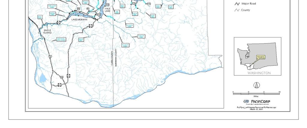
4 addition to the slope line, data labels on the graph will display the percent gradient between contours. Task 4: Qualitative Descriptions of Anadromous Fish - Qualitative descriptions of anadromous fish habitat found in the existing information will be included and cited in a report. As available, this will include historic use by anadromous fish and descriptions of physical parameters such as general substrate size and distribution, summer and fall low flows and temperatures, riparian quality, and instream cover. Field observations of habitat quality will be made and reported as time permits Key Questions The study objectives identified in Section were derived from key questions developed through the watershed scoping process in A summary of these key questions follows: How much habitat would potentially become accessible to each species of anadromous fish if they were reintroduced to upstream habitat areas? A summary of the amount of potential habitat that would be accessible to anadromous fish if they were reintroduced above Merwin, Yale and Swift dams is presented in Table in the 2000 Technical Study Status Reports (PacifiCorp and Cowlitz PUD 2001). This table describes the length, width, area, and average gradient of accessible anadromous fish habitat and the percent of total accessible habitat in 3 reaches (the Lake Merwin reach, Yale Lake reach and Swift Reservoir reach). What is the location and type of natural and artificial fish barriers present in the basin? The locations of anadromous fish migration barriers encountered during the field survey and derived from existing literature sources are presented in Figure Photographs of barriers encountered during the field survey and classifications of barrier types [using methods described in Powers and Orsborn (1985)] are included in AQU 4 Appendix 1. AQU 4 Appendix 1 also includes photographs of representative habitat in the surveyed streams, a narrative qualitative description of habitat quality, Rosgen (1996) stream channel classifications and detailed charts illustrating channel gradient. What is the estimated fish production potential for each fish species that may be reintroduced to upstream areas? Mobrand Biometrics, Inc. and the ARG are currently developing an EDT-based assessment of production potential for the upper basin tributaries. Using the habitat data collected by the USFS and the Licensee (referenced in AQU 4), the EDT model should provide a fairly robust estimate of production potential for the 3 Lewis River reaches. Page AQU Final Technical Reports April 2004
5 4.4.5 Results Based on a review of existing information and field surveys conducted in September and October of 1999 and September 2000, there are approximately 96.1 miles (155 km) of potentially accessible anadromous fish habitat in the North Fork Lewis River basin upstream from Merwin Dam (Figure 4.4-1; Table 4.4-1). Of this potentially accessible habitat, 6.2 miles (9.9 km) (6.5 percent) are located between Merwin Dam and the base of Yale Dam. Approximately 15.8 miles (25.4 km) (16.4 percent) are between Yale Dam and the base of Swift Dam, and the remaining 74.1 miles (119 km) (77.1 percent) are upstream from Swift Dam. In addition to the stream length information described above, detailed habitat area estimates (in square feet) were calculated using wetted width measurements collected in the field or taken directly from existing survey data. Because these wetted width measurements were usually collected during low flow conditions, the area calculations (generated by the length and width data) typically represent an estimate of the minimum amount of potentially accessible habitat. As expected, the total area and percent area calculations paralleled the length-based calculations. The North Fork Lewis River basin above Merwin Dam contains an estimated 20,583,173 square feet (1,912,239 m 2 ) of potentially accessible anadromous fish habitat. Of this habitat area, 361,702 square feet (33,603 m 2 ) (1.8 percent) are located between Merwin Dam and the base of Yale Dam. Approximately 2,753,035 square feet (255,765 m 2 ) (13.4 percent) are between Yale Dam and the base of Swift Dam, and the remaining 17,468,436 square feet (1,622,871 m 2 ) (84.9 percent) are upstream of Swift Dam. stream gradients range from 0.6 to 22.5 percent, but typically were variable throughout the surveyed potions of the stream (Table 4.4-1). More detailed descriptions of potentially accessible habitat, detailed charts illustrating individual stream gradients (by 40-foot [12 m] contour intervals), descriptions of each barrier using methods developed by Powers and Orsborn (1985), Rosgen (1996) channel types, and photographs of each stream surveyed in the field were prepared and are presented in AQU 4 Appendix 1. Descriptions of individual Rosgen (1996) channel types are also included in this appendix. These descriptive summaries are presented in a downstream to upstream order and separated by reservoir reach. Anadromous salmonid production potential estimates are currently being developed by the WDFW, USFS, and other members of the ARG Discussion Merwin, Yale and Swift dams block the upstream and downstream migration of both resident and anadromous fish, and inundate over 39 miles of historical riverine habitat. This loss of historical habitat, combined with other factors, has contributed to an overall decline in the abundance of both native and wild (non-hatchery) resident and anadromous fish populations. April 2004 Final Technical Reports - Page AQU 4-5
6 During the watershed study scoping and planning process in 1997 and 1998, the ARG identified the need for a series of studies designed to determine the feasibility of reintroducing anadromous fish into the upper Lewis River Basin. The primary objective of this study (AQU 4) was to quantify the amount of potentially accessible anadromous fish habitat in the North Fork Lewis River above Merwin, Yale and Swift dams. The results of this study, as presented in PacifiCorp and Cowlitz PUD (2001), indicate that there are over 96.1 miles of potentially accessible riverine habitat still available above Merwin Dam. The Lake Merwin reach, located between Merwin Dam and Yale Dam, contains 6.2 miles of potentially accessible anadromous fish habitat. The Yale Lake reach, located between Yale Dam and Swift Dam, contains 15.8 miles of potentially accessible habitat, and the Swift Reservoir reach contains 74.1 miles of accessible habitat. As can be seen from these data, the vast majority of this habitat (77.1 percent of the total) is located in the mainstem and tributary reaches above Swift Dam. Prior to the completion of Merwin, Yale and Swift dams, the river and stream reaches in the upper Lewis River Basin supported large numbers of spring and fall Chinook, coho and winter steelhead (Smoker et al. 1951). The majority of the Lewis River fall Chinook spawned in the mainstem Lewis River downstream from the Merwin Dam site and in the mainstem reaches that are now inundated by Lake Merwin, Yale Lake and Swift Reservoir. As can be seen from the results of this study, the river and stream reaches located in the upper basin still contain a substantial amount of relatively high quality habitat capable of supporting one or more species of anadromous fish. With the information collected during this assessment, the ARG members can move forward in their analysis of anadromous fish production potential and in their development of one or more ecologically sound reintroduction alternatives. The reintroduction alternatives or actions developed by the ARG will be based on the ability of a reservoir reach (or multiple reaches) to support self-sustaining populations of anadromous fish, the effects of the reintroduction action on ESA-listed fish species, interactions with other resource measures, and the costs associated with implementation (including the costs of appropriate fish passage facilities and supplementation efforts) Schedule This study is complete. Page AQU Final Technical Reports April 2004
7
8 Table The length, width, area, and average gradient of accessible anadromous fish habitat and the percent of total accessible habitat in 3 reaches of the North Fork Lewis River upstream of Merwin Dam. Reach Name* LAKE MERWIN Length of Length of (miles) Wetted Width Bankfull Width Wetted Area (ft 2 ) Gradient (%) Estimated Flow (cfs) Percent of (by area) Percent of (by length) Marble Creek % 0.0% Harza (1999) Cape Horn Creek 1, , % 0.3% Harza (1999) Jim Creek 3, , % 0.6% Harza (1999) Indian George Creek 4, , % 0.9% Harza (1999) Buncombe Hollow Creek 4, , % 0.8% Harza (1999) M4 3, , % 0.8% Harza (1999) Rock Creek , % 0.1% Harza (1999) Brooks Creek 5, , % 1.1% Harza (1999) B1 2, , % 0.5% Harza (1999) M14 6, , % 1.3% Harza (1999) Canyon Creek NA NA NA NA NS 0.0% 0.0% Harza (1999) YALE LAKE Lake Merwin 32, , % 6.5% Siouxon Creek 18, ,014, % 3.6% Harza (2000) North Siouxon Creek 10, , % 2.2% Harza (2000) Speelyai Creek 16, , % 3.3% Harza (1999) West Fork Speelyai *** NS NS NS NS NS NS NS NS NS NS Y8 1, , % 0.2% Harza (1999) Dog Creek 7, , to % 1.5% Harza (1999) Cougar Creek 8, , % 1.8% USFS (1995a) Panamaker Creek 1, , % 0.3% Harza (1995) Source April 2004 Final Technical Reports - Page AQU 4-9
9 Table The length, width, area, and average gradient of accessible anadromous fish habitat and the percent of total accessible habitat in 3 reaches of the North Fork Lewis River upstream of Merwin Dam (cont.). Reach Name* Length of Length of (miles) Wetted Width Bankfull Width Wetted Area (ft 2 ) Gradient (%) Estimated Flow (cfs) Percent of (by area) Percent of (by length) Source North Fork Lewis River 14, , % 2.8% Harza (1995) Ole Creek 4, , to % 0.8% Harza (1995) Rain Creek **** NS Harza (1999) Yale Lake 83, ,753, % 16.4% SWIFT RESERVOIR Swift Creek 1, NA 48, % 0.3% USFS (1995b) Diamond Creek , % 0.1% Harza (1999) Range Creek 3, , % 0.7% USFS (1995c) S10 1, , % 0.4% Harza (1999) Drift Creek 8, , % 1.7% USFS (1995d) S15 6, , % 1.3% Harza (1999) North Fork Lewis River 69, ,203, ** 35.0% 13.7% Harza (1999) Pine Creek 42, ,161, % 8.3% USFS (1994a) P1 4, , % 0.9% Harza (1999) P3 5, , % 1.0% Harza (1999) P7 5, , % 1.1% Harza (1999) P8 22, , % 4.3% Harza (1999) P10 1, , % 0.3% Harza (1999) Muddy River 72, ,519, % 14.4% USFS (1995e) Clear Creek 65, NA 2,335, % 12.8% USFS (1997) Clearwater Creek 27, ,459, % 5.4% Harza (2000) Smith Creek 30, NA 537, % 6.0% USFS (1998) April 2004 Final Technical Reports - Page AQU 4-10
10 Table The length, width, area, and average gradient of accessible anadromous fish habitat and the percent of total accessible habitat in 3 reaches of the North Fork Lewis River upstream of Merwin Dam (cont.). Reach Name* Length of Length of (miles) Wetted Width Bankfull Width Wetted Area (ft 2 ) Gradient (%) Estimated Flow (cfs) Percent of (by area) Percent of (by length) Source U8 1, , % 0.4% Harza (1999) Pepper Creek 2, , % 0.4% USFS (1989a) Rush Creek 8, , ** 1.1% 1.8% USFS (1994b) Little Creek 1, NA 16, % 0.3% USFS (1990) Big Creek 1, , % 0.3% USFS (1991) Spencer Creek 3, , % 0.6% Harza (1999) Cussed Hollow Creek 1, , % 0.3% USFS (1989b) Chickoon Creek 1, , % 0.3% USFS (1989c) Swift Reservoir 391, ,468, % 77.1% Grand (all reaches) 507, ,583, % 100.0% * The "Lake Merwin" reach extends from Merwin Dam to the base of Yale Dam, the "Yale Lake" reach extends from Yale Dam to the base of Swift Dam and the "Swift Reservoir" reach extends from Swift Dam to the lower falls on the North Fork Lewis River. ** Estimate based on historical gage data. *** West Fork Speelyai Creek was not surveyed due to access difficulties and time constraints. **** Rain Creek lacked surface flow in September 1999 (during low flow conditions). NS = Not surveyed. April 2004 Final Technical Reports - Page AQU 4-11
11 4.4.8 References Chambers, J.S Report on the 1956 survey of the North Fork of the Lewis River above Yale Dam. State of Washington Department of Fisheries. Prepared for Pacific Power & Light. Kray, A A survey of resident game fish resources on the North Fork of the Lewis River with a post flooding management plan. State of Washington Department of Fisheries. Prepared for Pacific Power & Light. PacifiCorp and Cowlitz PUD. 1999, as amended. Study Plan Document for the Lewis River Hydroelectric Projects. Portland, OR and Longview, WA. March 29, 1999, as amended. PacifiCorp and Cowlitz PUD Technical Study Status Reports for the Lewis River Hydroelectric Projects. Portland, OR, and Longview, WA. March Powers, P.D., and J.F. Orsborn Analysis of barriers to upstream migration. An investigation of the physical and biological conditions affecting fish passage success at culverts and waterfalls. Final report part 4 of 4, development of new concepts in fish ladder design. Project No , Bonneville Power Administration, Portland, OR. August Rosgen, D.R Applied River Morphology. Wildland Hydrology, Pasoga Springs, CO. Smoker, W.A., J.M. Hurley, and R.C. Meigs Compilation of observations on the effect of Ariel Dam on the production of salmon and trout in the Lewis River. State of Washington Department of Fisheries and State of Washington Department of Game. Olympia, WA. Page AQU Final Technical Reports April 2004
12 4.4.9 Comments and Responses on Draft Report This section presents stakeholder comments provided on the draft report, followed by the Licensees responses. The final column presents any follow-up comment offered by the stakeholder and in some cases, in italics, a response from the Licensees. Commenter Volume Page/ Paragraph Statement Comment Response Response to Responses TWHB 5 AQU 04 Data Summary Section not in volume We regret this apparent error by the printer. This material is present in other copies. USDA Forest Service: John Kinney 1 AQU 04 General Comment There needs to be an identifiable linkage between AQU-1 fish habitat requirements and the interpretation and results of AQU-4 This linkage will be developed in detail in the Conceptual Foundation document (Lewis River Fish Planning Document) currently being prepared by the Licensee s consultants. USDA Forest Service: John Kinney 1 AQU 04 Objectives 1-4 In particular #4 The data is of limited value when describing the quality of accessible anadromous aquatic habitat. There was no substantive description or discussion of habitat units or stream channel characteristics that would provide an indication of overall stream condition (presence of large wood, riparian health, boulders etc). Recently, the Forest Service provided a draft copy of a stream summary report with some of the necessary aquatic habitat information to the ARG and proponents. Therefore, this study was considered incomplete by the Forest Service. Qualitative descriptions of habitat characteristics found in each of the surveyed streams (including substrate composition, riparian condition, channel type, channel gradient, and cover characteristics) are provided in the Data Summary Sheets (provided in the Appendices to the 2000 Technical Study Status Reports). Photographs of representative habitat and barriers are also included in these summary sheets. This information will be USDA Forest Service crews found most juvenile coho salmon occupying un-named side tributaries to named streams. Many of those unnamed tributaries have not, or were not, surveyed for aquatic habitat attributes or for length of accessible habitat. In other words, the amount of accessible habitat reported may be underestimated. To what extent is yet to be determined. We would suggest discussing this situation. April 2004 Final Technical Reports - Page AQU 4-13
13 Commenter WDFW JIM BYRNE WDFW KAREN Volume Page/ Paragraph Statement Comment Response Response to Responses incorporated into the Appendices to the final report. 1 AQU 04 Assessment Above Merwin. Only physical characteristics are provided: stream lengths to barriers, gradients and wetted widths. More qualitative and quantitative descriptions of habitat, substrate composition, riparian vegetation, etc., would be more useful. A creek may be 1,132 feet to an impassible barrier, but it is all bedrock it is of no value to fish. 1 AQU 04 Stream habitat. Were the streams looked at from Chinook or sea-run cutthroat habitat We agree that the draft USFS stream summary report provides valuable information describing habitat conditions in the basin and we encourage the ARG members to review this information in addition to other referenced USFS stream habitat surveys. Qualitative descriptions of habitat characteristics found in each of the surveyed streams (including substrate composition, riparian condition, channel type, channel gradient, and cover characteristics) are provided in the Data Summary Sheets included in the Appendices to the 2000 Technical Study Status Reports. Photographs of representative habitat are also included in the Summary Sheets. This information will be incorporated into the Appendices to the final report. Because anadromous fish reintroduction may occur in Licensees Response: We concur that there likely IS more habitat than has been measured. I have the 2000 Technical Study Status Reports but no appendices. Descriptions in the 1999Technical Study Status Reports are just a few sentences. Licensees Response: The information is presented in this report. April 2004 Final Technical Reports - Page AQU 4-14
14 Commenter KLOEMPKEN Volume Page/ Paragraph Statement Comment Response Response to Responses point? the surveyed stream reaches, professional opinion was Some of the streams mentioned as used to qualitatively assess anadromous and resident use, but potential use by anadromous mostly only mention of anadromous. salmonids. Focus species Why not more resident? were Chinook, coho and steelhead; however; many of There is a statement about the Muddy these stream reaches are River is poor fish habitat. Weren t currently used by resident coho radio tracked going up the cutthroat trout and rainbow Muddy to spawn? trout. Reference to Smith Creek What about anadromous habitat? The Little Creek sounds like perfect anadromous juvenile rearing/over wintering habitat. Was only habitat for adults considered? We agree that Muddy River and Smith Creek have the potential to support anadromous salmonids including coho, Chinook and steelhead. Despite the effects of the Mt. St. Helens eruption, radio telemetry studies showed that coho definitely prefer the Muddy River. Although spawning habitat may be limited in Little Creek, we also agree that it does contain valuable rearing/over wintering habitat especially for coho salmon and cutthroat trout. April 2004 Final Technical Reports - Page AQU 4-15
15 Commenter Volume Page/ Paragraph Statement Comment Response Response to Responses TWHB 1 AQU 04-1 Methods The methods are not described but referenced in a separate document. The methods description for this study is over 3 pages This makes understanding difficult long, so it was not and requires regressing to that document. At least a synthesis of methods should be described. reproduced here. We will provide a more thorough summary of the methods for the final report. TWHB 1 AQU 04-1 Key Questions: How much habitat would potentially become acc.. The referenced table and figures included and appendix with the document. I could not find the appendix in volume 4. This information is presented in Volume 5. WDFW JIM BYRNE And what is location and type 1 AQU 04-1 Objectives. The objectives call for estimating area and estimating production potential. Production estimates are not available. Mobrand Biometrics, Inc. and members of the ARG developed an Excel-based model designed to derive the number of juvenile outmigrants that could potentially be produced by habitat located upstream from Merwin Dam. The ARG is also currently evaluating the need for an EDT-based assessment of production potential for the upper basin tributaries. We need to do EDT. Licensees Response: An EDT study is being performed. April 2004 Final Technical Reports - Page AQU 4-16
16 Commenter Volume Page/ Paragraph Statement Comment Response Response to Responses TWHB 1 AQU 04-2 An Excelbased model designed to derive the production potential of habitat located upstream of Merwin This is an inaccurate statement. The model was developed to assess fish passage alternatives and given a starting point of juvenile out migrants based on number of river miles. This is not analogous to a habitat based production model (EDT and others are directed at the production issue). The fish passage model is being oversold as an analytical tool and this is example of its miss use. I will have more to say about this model if it remains in use, but the models utility, strengths, and shortcoming needs to be described. This statement will be revised in the final report to reflect its utility and limitations. The model output will play a pivotal role in the development of the Lewis River Fish Planning Document (AQU 18), and in the reintroduction planning effort (desired future conditions). Mobrand Biometrics, Inc. and the ARG are currently evaluating the need for an EDT based assessment of production potential for the upper basin tributaries. Using the habitat data collected by the USFS and the Licensee (referenced in AQU 4), the EDT model should provide a fairly robust estimate of production potential for the three Lewis River reaches. TWHB 1 AQU 04-2 Results The general physical descriptions provided are useful components of a full watershed assessment. The USFS level 2, EDT or protocols and others can be utilized to evaluate value of the information for recovery planning. The Gifford Pinchot National Forest has provided additional information on the tributaries that needs to be included. Agreed, more detailed habitat information collected by the USFS and the Licensees will be reviewed and entered into the EDT model. April 2004 Final Technical Reports - Page AQU 4-17
17 Commenter Volume Page/ Paragraph Statement Comment Response Response to Responses The fish management framework document proposed by the ARG on July 8, 2002 would be a starting place to evaluate desired future conditions (the puzzle, mentioned above) and the relevance of this and the other habitat /water quality studies to that end. USDA Forest Service: John Kinney 1 AQU 04-8 para 1 Last sentence: production potential At this time, I am unsure who is developing this information for the ARG. Mobrand Biometrics, Inc. and the ARG developed an Excel-based model designed to derive the number of juvenile outmigrants that could potentially be produced by habitat located upstream from Merwin Dam (the Lake Merwin reach, Yale Lake reach and Swift Reservoir reach). The ARG is also currently evaluating the need for an EDT based assessment of production potential for the upper basin tributaries. Using data collected by the USFS and the Licensee, the EDT model will provide a fairly robust estimate of production potential. April 2004 Final Technical Reports - Page AQU 4-18
Packwood Hydroelectric Project Barrier Analysis December 12, 2006
 Packwood Hydroelectric Project Barrier Analysis December 12, 2006 Study Area Natural barriers to upstream fish passage on Lake Creek at RM 1.03 and RM 1.95 Snyder Creek culvert under the Project tailrace
Interim Guidance Fish Presence Absence
 Interim Guidance Fish Presence Absence Source: Forest Practices Act Guidance for Division 635 of the forest practices act dealing with stream classification when no fish surveys have been done (referenced
Lake Merwin and Swift Creek Reservoir Tributaries. Bull Trout Limiting Factors Analysis
 Lake Merwin and Swift Creek Reservoir Tributaries Bull Trout Limiting Factors Analysis Study Objectives Answer Key? s Do other tributaries to Swift Creek Reservoir and Lake Merwin not known to support
Final Bull Trout Genetics Monitoring Plan for the Wallowa Falls Hydroelectric Project. (FERC No. P-308) June 2017
 June 2017") Final for the Wallowa Falls Hydroelectric Project (FERC No. P-308) June 2017 Prepared by: Jeremiah Doyle PacifiCorp 825 NE Multnomah Street Portland, OR 97232 June, 2017 Page 1 of 8 Table of Contents 1.0
Final for the Wallowa Falls Hydroelectric Project (FERC No. P-308) June 2017 Prepared by: Jeremiah Doyle PacifiCorp 825 NE Multnomah Street Portland, OR 97232 June, 2017 Page 1 of 8 Table of Contents 1.0
INTERIM REPORT LAKE CREEK ANADROMOUS BARRIER ANALYSIS
 INTERIM REPORT LAKE CREEK ANADROMOUS BARRIER ANALYSIS Prepared for Energy Northwest Prepared by EES Consulting JULY 2005 INTERIM REPORT LAKE CREEK ANADROMOUS BARRIER ANALYSIS SECTION 1: INTRODUCTION In
Study Update Fish Distribution and Species Composition
 Study Update Fish Distribution and Species Composition Goals and Study Area Gain a better understanding of fish species composition and abundance in waters associated with the Packwood Lake Hydroelectric
APPENDIX D: LEWIS RIVER HATCHERY REVIEW
 APPENDIX D: LEWIS RIVER HATCHERY REVIEW JANUARY 14, 2004 Prepared for PacifiCorp and Cowlitz PUD Prepared by S.P. Cramer & Associates, Inc. 600 NW Fariss Gresham, Oregon 97030 www.spcramer.com D-1 TABLE
Study Update Tailrace Slough Use by Anadromous Salmonids
 Study Update Tailrace Slough Use by Anadromous Salmonids Goals and Objectives Identify what anadromous salmonids use the tailrace slough by: Life Stage (Juvenile, migrating and spawning adults) Timing
Lewis River Hydroelectric Projects Settlement Agreement Aquatic Coordination Committee (ACC) Meeting Agenda
 Meeting Agenda") Lewis River Hydroelectric Projects Settlement Agreement Aquatic Coordination Committee (ACC) Meeting Agenda Date & Time: Thursday, September 4, 27 9: a.m. : a.m. Place: CONFERENCE CALL ONLY Contacts: Frank
Lewis River Hydroelectric Projects Settlement Agreement Aquatic Coordination Committee (ACC) Meeting Agenda Date & Time: Thursday, September 4, 27 9: a.m. : a.m. Place: CONFERENCE CALL ONLY Contacts: Frank
BATTLE CREEK FISHERIES STUDIES TASK 4: SURVEYS OF BARRIERS TO THE UPSTREAM MIGRATION OF ANADROMOUS SALMONIDS
 BATTLE CREEK FISHERIES STUDIES TASK 4: SURVEYS OF BARRIERS TO THE UPSTREAM MIGRATION OF ANADROMOUS SALMONIDS Prepared for: California Department of Fish and Game Redding, California 96001 Prepared by:
Final Bull Trout Redd Monitoring Report for the Wallowa Falls Hydroelectric Project
 Final for the Wallowa Falls Hydroelectric Project East Fork Wallowa River barrier to upstream fish migration, photo courtesy of Kendrick Moholt (FERC No. P-308) December 18, 2017 Prepared by: Jeremiah
Five Counties Salmonid Conservation Program - Fish Passage Design Workshop. February 2013
 Program - Aquatic Organisms and Stream Crossings Ecological Connectivity A watershed is a network of channels that drain a common boundary. Channel characteristics formed by interaction of precipitation,
Lewis River Hydroelectric Projects Settlement Agreement Aquatic Coordination Committee (ACC) Meeting Agenda
 Meeting Agenda") Lewis River Hydroelectric Projects Settlement Agreement Aquatic Coordination Committee (ACC) Meeting Agenda Date & Time: Thursday, December 14, 2017 9:00 a.m. 11:15 a.m. Place: Merwin Hydro Control Center
Lewis River Hydroelectric Projects Settlement Agreement Aquatic Coordination Committee (ACC) Meeting Agenda Date & Time: Thursday, December 14, 2017 9:00 a.m. 11:15 a.m. Place: Merwin Hydro Control Center
PRE- PROPOSAL FORM - Lewis River Aquatic Fund
 PRE- PROPOSAL FORM - Lewis River Aquatic Fund 1. Applicant organization. USDA Forest Service Gifford Pinchot National Forest 2. Organization purpose Resource management agency 3. Project manager (name,
Yale Reservoir Kokanee (Oncorhynchus nerka) Escapement Report 2016
 Escapement Report 2016") Yale Reservoir Kokanee (Oncorhynchus nerka) Escapement Report 2016 North Fork Lewis River Hydroelectric Project Yale FERC No. 2071 Prepared by: Jeremiah Doyle, PacifiCorp April 4, 2017 1.0 INTRODUCTION
Yale Reservoir Kokanee (Oncorhynchus nerka) Escapement Report 2016 North Fork Lewis River Hydroelectric Project Yale FERC No. 2071 Prepared by: Jeremiah Doyle, PacifiCorp April 4, 2017 1.0 INTRODUCTION
Southern Oregon Coastal Cutthroat Trout
 Species Management Unit Description Southern Oregon Coastal Cutthroat Trout The Southern Oregon Coastal Cutthroat Trout SMU includes all populations of cutthroat trout inhabiting ocean tributary streams
Newaukum Watershed Culvert Assessment
 Newaukum Watershed Culvert Assessment Water Resource Inventory Area 23 Lewis County Conservation District Final Report By: Kelly Verd and Nikki Wilson July 2002 Funded by: Chehalis Fisheries Restoration
Lewis River Hydroelectric Projects Settlement Agreement Aquatic Coordination Committee (ACC) Meeting Agenda
 Meeting Agenda") Lewis River Hydroelectric Projects Settlement Agreement Aquatic Coordination Committee (ACC) Meeting Agenda Date & Time: Thursday, August, 27 9: a.m. :45 a.m. Place: CONFERENCE CALL ONLY Contacts: Frank
Lewis River Hydroelectric Projects Settlement Agreement Aquatic Coordination Committee (ACC) Meeting Agenda Date & Time: Thursday, August, 27 9: a.m. :45 a.m. Place: CONFERENCE CALL ONLY Contacts: Frank
Abundance of Steelhead and Coho Salmon in the Lagunitas Creek Drainage, Marin County, California
 scanned for KRIS Abundance of Steelhead and Coho Salmon in the Lagunitas Creek Drainage, Marin County, California Prepared for: Marin Municipal Water District 220 Nellen Drive Corte Madera, California
1. Project Title Bull Trout Habitat Restoration Project Identification Assessment. 3. Identification of problem or opportunity to be addressed
 PROPOSAL FORM - Lewis River Aquatic Fund 1. Project Title Bull Trout Habitat Restoration Project Identification Assessment 2. Project Manager Adam Haspiel USFS Abi Groskopf Mount S. Helens Institute (MSHI)
Fish Passage Culvert Assessment for Cahilty Creek Watershed FIA Project #
 Fish Passage Culvert Assessment for Cahilty Creek Watershed FIA Project # 4602004 Prepared for Weyerhaeuser Company Ltd. Jason Ladyman R.P.F. 1550 Mission Flats Road PO Box 40 Kamloops BC V2C 5K3 Prepared
Packwood Lake Hydroelectric Project (FERC No. P-2244) Anadromous Salmonid Habitat and Spawner Survey Report
 Anadromous Salmonid Habitat and Spawner Survey Report") Packwood Lake Hydroelectric Project (FERC No. P-2244) Anadromous Salmonid Habitat and Spawner Survey Report Prepared For Prepared By EES Consulting 1155 N. State Street, Suite 700 Bellingham, WA 98225
Packwood Lake Hydroelectric Project (FERC No. P-2244) Anadromous Salmonid Habitat and Spawner Survey Report Prepared For Prepared By EES Consulting 1155 N. State Street, Suite 700 Bellingham, WA 98225
Assessment of Baseline Geomorphic Features at. Proposed Stream Crossings On The Proposed County Road 595. Marquette County, Michigan
 Assessment of Baseline Geomorphic Features at Proposed Stream Crossings On The Proposed County Road 595 Marquette County, Michigan Prepared for: Kennecott Eagle Minerals Company Marquette, Michigan Prepared
LEWIS RIVER FISH PLANNING DOCUMENT
 LEWIS RIVER FISH PLANNING DOCUMENT Prepared for PacifiCorp and Cowlitz PUD April 2004 S. P. Cramer & Associates, Inc. 600 NW Fariss Gresham, OR 97030 (503) 491-9577 www.spcramer.com EXECUTIVE SUMMARY The
Klamath Lake Bull Trout
 Klamath Lake Bull Trout Existing Populations The Klamath Lake Bull Trout SMU is comprised of seven existing populations and four populations classified as extinct or functionally extinct (Table 189). Populations
South Fork Chehalis Watershed Culvert Assessment
 South Fork Chehalis Watershed Culvert Assessment Water Resource Inventory Area 23 Lewis County Conservation District Final Report By: Kelly Verd and Nikki Wilson March 2003 Funded by: The Washington State
3. The qualification raised by the ISRP is addressed in #2 above and in the work area submittal and review by the ISRP as addressed in #1.
 Please find attached a response from The Confederated Tribes of the Warm Springs Reservation of Oregon (CTWSRO) for Project # 2008-301-00, Habitat Restoration Planning, Design and Implementation within
Executive Summary. Map 1. The Santa Clara River watershed with topography.
 Santa Clara River Steelhead Trout: Assessment and Recovery Opportunities December 2005 Prepared By: Matt Stoecker and Elise Kelley, Ph.D. University of California, Santa Barbara Prepared For: The Santa
Packwood Lake Intake Screen Velocity Test Report for Energy Northwest's Packwood Lake Hydroelectric Project FERC No Lewis County, Washington
 for Energy Northwest's Packwood Lake Hydroelectric Project FERC No. 2244 Lewis County, Washington Submitted to P.O. Box 968 Richland, Washington 99352-0968 Submitted by EES Consulting 1155 North State
Big Spring Creek Habitat Enhancement and Fishery Management Plans
 Big Spring Creek Habitat Enhancement and Fishery Management Plans November 5, 2012 Big Spring Events and Activities Center Newville, PA Charlie McGarrell Regional Habitat Biologist Pennsylvania Fish and
STREAM SURVEY File form No..
 scanned for KRIS THE RESOURCES AGENCY OF CALIFORNIA California Department of Fish and Game STREAM SURVEY File form No.. Date: September 4, 1969. NAME: North Fork Schooner Gulch Creek COUNTY: Mendocino.
Oregon Coast Coastal Cutthroat Trout
 Oregon Coast Coastal Cutthroat Trout Species Management Unit Description The Oregon Coast Coastal Cutthroat Trout Species Management Unit (SMU) includes all populations of cutthroat trout inhabiting ocean
Redd Dewatering and Juvenile Salmonid Stranding in the Lower Feather River,
 Redd Dewatering and Juvenile Salmonid Stranding in the Lower Feather River, 2005-2006 Interim Report for NOAA Fisheries Prepared by: California Department of Water Resources Division of Environmental Services
Lewis River Bull Trout Habitat Restoration Project Identification Assessment
 Lewis River Bull Trout Habitat Restoration Project Identification Assessment Jamie Lamperth 1, Bryce Michaelis 2, and Abi Groskopf 3 1 Washington Department of Fish and Wildlife, Fish Ecology and Life
Yakima River Basin Coho Reintroduction Feasibility Study
 Yakima River Basin Coho Reintroduction Feasibility Study Yakima Klickitat Fisheries Project Goals and Mission The purposes of the YKFP are to: enhance existing stocks of anadromous fish in the Yakima and
PRE- PROPOSAL FORM - 1. Applicant organization. USDA Forest Service Gifford Pinchot National Forest & WDFW Region 5
 PRE- PROPOSAL FORM - 1. Applicant organization. USDA Forest Service Gifford Pinchot National Forest & WDFW Region 5 2. Organization purpose USFS-Resource management agency WDFW-Fish and Wildlife management
Proposed Habitat Suitability Criteria (HSC) Curves For Application in Habitat Flow Modeling For the Sultan River Instream Flow Study RSP 3
 Curves For Application in Habitat Flow Modeling For the Sultan River Instream Flow Study RSP 3") - - Proposed Habitat Suitability Criteria (HSC) Curves For Application in Habitat Flow Modeling For the Sultan River Instream Flow Study RSP 3 Prepared for: Public Utility District No. 1 of Snohomish County
- - Proposed Habitat Suitability Criteria (HSC) Curves For Application in Habitat Flow Modeling For the Sultan River Instream Flow Study RSP 3 Prepared for: Public Utility District No. 1 of Snohomish County
OREGON DEPARTMENT OF FISH AND WILDLIFE ROGUE FISH DISTRICT REPORT
 OREGON DEPARTMENT OF FISH AND WILDLIFE ROGUE FISH DISTRICT REPORT TITLE: Upper Rogue Smolt Trapping Project, 1999 STREAM: Big Butte, Little Butte, South Fork Big Butte, Slate and West Fork Evans Creeks
Summary of HSRG Findings for Chum Populations in the Lower Columbia River and Gorge
 Summary of HSRG Findings for Chum Populations in the Lower Columbia River and Gorge The Congressionally-established Hatchery and Scientific Review Group (HSRG) developed a foundation of salmon hatchery
Fish Passage at Road Crossings Assessment Boise National Forest FY 2004
 Culvert Inventory Summary 2004 - Boise National Forest Fish Passage at Road Crossings Assessment Boise National Forest FY 2004 Feather River at Road #135 Crossing By Michael S. Kellett, Fishery Biologist
Summary of the Pilot Assessment of Three Potential Fish Barriers on Battle Creek
 Summary of the Pilot Assessment of Three Potential Fish Barriers on Battle Creek Laurie A. Earley March 2014 U.S. Fish and Wildlife Service, Red Bluff Fish and Wildlife Office 10950 Tyler Road, Red Bluff,
STREAM CLASSIFICATION AND MAPPING. Prepared For. MacMillan Bloedel Ltd. Menzies Bay Division BOX 6000, Campbell River V9W 5E1.
 STREAM CLASSIFICATION AND MAPPING OF STREAMS IN MENZIES AND OYSTER BAY Prepared For MacMillan Bloedel Ltd. Menzies Bay Division BOX 6000, Campbell River V9W 5E1 September 1998 a a North Island Biological
Fish Habitat Restoration and Monitoring in Southeast Washington. Andy Hill Eco Logical Research, Inc.
 Fish Habitat Restoration and Monitoring in Southeast Washington Andy Hill Eco Logical Research, Inc. Fish Habitat Restoration and Monitoring in Southeast Washington Talk overview: Restoration projects
FISH PASSAGE IMPROVEMENT in California s Watersheds. Assessments & Recommendations by the Fish Passage Forum
 FISH PASSAGE IMPROVEMENT in California s Watersheds Assessments & Recommendations by the Fish Passage Forum FISH PASSAGE IMPROVEMENT in California s Watersheds The mission of the Fish Passage Forum is
Lewis River Upstream Transport Plan Interim Final. Prepared by Frank Shrier Principal Fish Biologist PacifiCorp Energy.
 Lewis River Interim Final Upstream Transport Plan Lewis River Upstream Transport Plan Interim Final Prepared by Frank Shrier Principal Fish Biologist PacifiCorp Energy December 18, 2009 Page 1 of 31 Table
Job 1. Title: Estimate abundance of juvenile trout and salmon.
 STUDY PERFORMANCE REPORT State: Michigan Project No.: F-53-R-13 Study No.: 461 Title: Population dynamics of juvenile rainbow trout and coho salmon in Lake Superior tributaries Period Covered: April 1,
Steve Hemstrom Sr. Fisheries Biologist Chelan PUD Natural Resources Desk: Cell:
 From: To: Cc: Subject: Date: Attachments: Hemstrom, Steven "Lewis, Stephen" Sokolowski, Rosana 2014 Rocky Reach Bull Trout Report Wednesday, June 18, 2014 3:01:07 PM Final 2014 Rocky Reach Bull Trout Observations
August 11 Snorkel SCC side channel network (SBA, SCC3) feet 707
 feet 707") Date Survey Type Habitat July 29 Snorkel (reconnaissance) Table 1. Fish use survey schedule 2004 Water temperature 1 (ºC) Estimated Mean visibility 2 discharge 3 (cfs) Mainstem (units #1 42) ND ND 814
Date Survey Type Habitat July 29 Snorkel (reconnaissance) Table 1. Fish use survey schedule 2004 Water temperature 1 (ºC) Estimated Mean visibility 2 discharge 3 (cfs) Mainstem (units #1 42) ND ND 814
Strategies for mitigating ecological effects of hatchery programs
 Strategies for mitigating ecological effects of hatchery programs Some case studies from the Pacific Northwest Kathryn Kostow Oregon Department of Fish and Wildlife Ecological risks occur when the presence
THE OREGON PLAN for. Salmon and Watersheds. Smith River Steelhead and Coho Monitoring Verification Study, Report Number: OPSW-ODFW
 THE OREGON PLAN for Salmon and Watersheds Smith River Steelhead and Coho Monitoring Verification Study, 2007 Report Number: OPSW-ODFW-2009-11 The Oregon Department of Fish and Wildlife prohibits discrimination
CHAPTER 4 DESIRED OUTCOMES: VISION, GOALS, AND OBJECTIVES
 CHAPTER 4 DESIRED OUTCOMES: VISION, GOALS, AND OBJECTIVES Vision One of the first steps in developing this Plan was articulating a vision - a clear statement of what the Plan strives to achieve and what
Summer Steelhead Surveys North Fork Trinity River Trinity County, California
 KRIS edition Summer Steelhead Surveys North Fork Trinity River Trinity County, California 1978-1997 By Loren Everest Fishery Biologist Weaverville Ranger District Shasta-Trinity National Forests October
SELBY CREEK SILVERADO TRAIL CULVERT FISH PASSAGE ASSESSMENT
 SELBY CREEK SILVERADO TRAIL CULVERT FISH PASSAGE ASSESSMENT NAPA COUNTY, CALIFORNIA PREPARED BY NAPA COUNTY RESOURCE CONSERVATION DISTRICT 1303 JEFFERSON ST. SUITE 500B NAPA, CALIFORNIA 94559 WWW.NAPARCD.ORG
TABLE OF CONTENTS LIST OF TABLES NONE LIST OF FIGURES NONE
 TABLE OF CONTENTS 7.4 RIVER-RELATED RECREATION SURVEYS (REC 4)... REC 4-1 7.4.1 Study Objectives... REC 4-1 7.4.2 Study Area... REC 4-1 7.4.3 Methods... REC 4-1 7.4.4 Key Questions... REC 4-3 7.4.5 Results...
Warner Lakes Redband Trout
 Warner Lakes Redband Trout Existing Populations Warner Valley is an endorheic basin that contains a complex series of interconnected lakes, marshes, sloughs, and potholes, all of which are remnants of
Okanagan Sockeye Reintroduction
 Okanagan Sockeye Reintroduction Backgrounder Elders accounts, and other forms of Traditional Ecological Knowledge (TEK) tell us that many species of salmon once came into the Okanagan Valley and tell us
Sub-watershed Summaries
 Project Description The Salmon Drift Creek Watershed Council (SDCWC) has focused their efforts in the Salmon River estuary for the past few years. The multifaceted partnership effort is nearing completion
Fish Passage Assessment of Private Stream Crossings on Lower Stonybrook Creek
 Fish Passage Assessment of Private Stream Crossings on Lower Stonybrook Creek Prepared by: Michael Love & Associates In cooperation with: Center for Ecosystem Management and Restoration Funded by: Coastal
Chinook Salmon Spawning Study Russian River Fall 2005
 Chinook Salmon Spawning Study Russian River Fall 2005 Sonoma County Water Agency 2150 West College Avenue Santa Rosa, California 95401 Prepared by David Cook - Senior Environmental Specialist March 27,
Susitna-Watana Hydroelectric Project (FERC No ) Salmon Escapement Study Study Plan Section 9.7
 Salmon Escapement Study Study Plan Section 9.7") (FERC No. 14241) Salmon Escapement Study Study Plan Section 9.7 Part D: Supplemental Information to June 2014 Initial Study Report Prepared for Prepared by LGL Alaska Research Associates, Inc. & Alaska
(FERC No. 14241) Salmon Escapement Study Study Plan Section 9.7 Part D: Supplemental Information to June 2014 Initial Study Report Prepared for Prepared by LGL Alaska Research Associates, Inc. & Alaska
FINAL Meeting Notes Lewis River License Implementation Aquatic Coordination Committee (ACC) Meeting November 8, 2007 Ariel, WA
 Meeting November 8, 2007 Ariel, WA") ACC Participants Present (19) FINAL Meeting Notes Lewis River License Implementation Aquatic Coordination Committee (ACC) Meeting November 8, 2007 Ariel, WA Jim Byrne, WDFW Clifford Casseseka, Yakama Nation
ACC Participants Present (19) FINAL Meeting Notes Lewis River License Implementation Aquatic Coordination Committee (ACC) Meeting November 8, 2007 Ariel, WA Jim Byrne, WDFW Clifford Casseseka, Yakama Nation
Deschutes Bull Trout
 Deschutes Bull Trout Existing Populations The Deschutes Bull Trout SMU is comprised of eight populations, three of which are classified as extinct (Table 1). Populations are identified according to those
Union Pacific Railroad
 Input Questions: 404/401 Pre Application Meeting, December 18, 2013, Portland, Oregon 1. What is the project purpose and need? The purpose of the project is to improve the efficiency and average velocity
State of San Francisco Bay 2011 Appendix O Steelhead Trout Production as an Indicator of Watershed Health
 State of San Francisco Bay 2011 Appendix O Steelhead Trout Production as an Indicator of Watershed Health Gordon Becker and Katherine Smetak, Center for Ecosystem Management and Restoration 290 Introduction
Aquatic Organism Passage at Road-Stream Crossings CHUCK KEEPORTS FOREST HYDROLOGIST ALLEGHENY NATIONAL FOREST WARREN, PENNSYLVANIA
 Aquatic Organism Passage at Road-Stream Crossings CHUCK KEEPORTS FOREST HYDROLOGIST ALLEGHENY NATIONAL FOREST WARREN, PENNSYLVANIA TOPICS COVERED Aquatic Organism Passage (AOP) Benefits of AOP Crossings
Burns Paiute Tribe Fisheries Department. Evaluate The Life History Of Native Salmonids Within The Malheur Subbasin Project #
 Burns Paiute Tribe Fisheries Department Evaluate The Life History Of Native Salmonids Within The Malheur Subbasin Project # 199701900 Prior to 1990 Technical and/or scientific background Malheur population,
Potlatch River Drainage: Salmonid Presence: Largest lower Clearwater River tributary
 X Y Potlatch River Drainage: Largest lower Clearwater River tributary Area = 1500 km 2 Mouth ~ 13 km upstream of Snake/Clearwater confluence X Y Dominated by private land Salmonid Presence: Steelhead,
Backgrounder and Frequently Asked Questions
 Backgrounder and Frequently Asked Questions Who Sent the Letter? The 60-day Notice of Intent to File Suit was sent by Conservation Angler, Wild Fish Conservancy, Snake River Waterkeeper, Friends of the
STEELHEAD SURVEYS IN OMAK CREEK
 STEELHEAD SURVEYS IN OMAK CREEK 2002 Annual Report Prepared by Chris Fisher John Arterburn Colville Confederated Tribes Fish and Wildlife Department P.O. Box 150 Nespelem, WA 99155 Prepared for Project
JOINT STAFF REPORT WINTER FACT SHEET NO. 9 Columbia River Compact March 18, 2004
 JOINT STAFF REPORT WINTER FACT SHEET NO. 9 Columbia River Compact March 18, 2004 Purpose: To review ongoing commercial fisheries and consider non-indian commercial fishing seasons for salmon, smelt and
Susitna-Watana Hydroelectric Project (FERC No ) Salmon Escapement Study Study Plan Section 9.7
 Salmon Escapement Study Study Plan Section 9.7") (FERC No. 14241) Salmon Escapement Study Study Plan Section 9.7 Initial Study Report Part C: Executive Summary and Section 7 Prepared for Prepared by LGL Alaska Research Associates, Inc. & Alaska Department
(FERC No. 14241) Salmon Escapement Study Study Plan Section 9.7 Initial Study Report Part C: Executive Summary and Section 7 Prepared for Prepared by LGL Alaska Research Associates, Inc. & Alaska Department
Management of headwater streams in the White Mountain National Forest
 Management of headwater streams in the White Mountain National Forest White Mountain National Forest Weeks Act of 1911 authorized the federal government to purchase lands east of the Mississippi River
Project Award Presentation
 University of Massachusetts Amherst ScholarWorks@UMass Amherst International Conference on Engineering and Ecohydrology for Fish Passage International Conference on Engineering and Ecohydrology for Fish
Trout Unlimited Comments on the Scope of Environmental Impact Statement for the Constitution Pipeline Project, Docket No. PF12-9
 October 9, 2012 Kimberly D. Bose, Secretary Federal Energy Regulatory Commission 888 First Street, NE, Room 1A Washington, DC 20426 RE: Trout Unlimited Comments on the Scope of Environmental Impact Statement
Youngs Creek Hydroelectric Project (FERC No. P 10359)
") Youngs Creek Hydroelectric Project (FERC No. P 10359) Resident Trout Monitoring Plan Annual Report 2010 Survey and Results of Pre Project Monitoring Prepared by: September 2010 Overview The Public Utility
Youngs Creek Hydroelectric Project (FERC No. P 10359) Resident Trout Monitoring Plan Annual Report 2010 Survey and Results of Pre Project Monitoring Prepared by: September 2010 Overview The Public Utility
107 FERC 61,282 UNITED STATES OF AMERICA FEDERAL ENERGY REGULATORY COMMISSION
 107 FERC 61,282 UNITED STATES OF AMERICA FEDERAL ENERGY REGULATORY COMMISSION Before Commissioners: Pat Wood, III, Chairman; Nora Mead Brownell, and Joseph T. Kelliher. Public Utility District No. 1 of
Aquatic Biological Assessment. Lassen 15 Restoration Project. Modoc National Forest Warner Mountain Ranger District
 Aquatic Biological Assessment Lassen 15 Restoration Project Modoc National Forest Warner Mountain Ranger District Prepared By:_/s/ Marty Yamagiwa Date: December 10, 2015 Marty Yamagiwa, Natural Resources
MEMORANDUM Oregon Department of Fish and Wildlife
 MEMORANDUM Oregon Department of Fish and Wildlife Date: January 18, 2019 To: From: Oregon Fish and Wildlife Commission Greg Apke, ODFW Statewide Fish Passage Program Coordinator Tom Murtagh, North Willamette
Ecology of Place: What salmon need Eric Beamer Skagit River System Cooperative. November 2010
 Ecology of Place: What salmon need Eric Beamer Skagit River System Cooperative November 2010 Acknowledgements NOAA Fisheries NW Fisheries Science Center Tim Beechie George Pess Correigh Greene Talk overview
REC 6 FISHERIES HABITAT EVALUATION
 REC 6 FISHERIES HABITAT EVALUATION 1.0 EXECUTIVE SUMMARY Analysis of fisheries habitat for recreational angling opportunities was completed by reviewing the results of the CAWG 1, Characterize Stream and
WFC 50 California s Wild Vertebrates Jan. 11, Inland Waters (Lakes and Streams) Lisa Thompson
 Lisa Thompson") Inland Waters: Lakes and Streams WFC 50 11 January 2011 Lisa Thompson Fisheries Extension Specialist Wildlife, Fish, & Conservation Biology Department University of California, Davis Take home messages
Inland Waters: Lakes and Streams WFC 50 11 January 2011 Lisa Thompson Fisheries Extension Specialist Wildlife, Fish, & Conservation Biology Department University of California, Davis Take home messages
THE CONFEDERATED TRIBES OF THE WARM SPRINGS RESERVATION OF OREGON
 THE CONFEDERATED TRIBES OF THE WARM SPRINGS RESERVATION OF OREGON To: Branch of Natural Resources P.0. Box C, Warm Springs, Oregon 97761 Phone (541) 553-2002/2003 Fax (541) 553-1994 The Independent Science
NEVADA DEPARTMENT OF WILDLIFE STATEWIDE FISHERIES MANAGEMENT
 NEVADA DEPARTMENT OF WILDLIFE STATEWIDE FISHERIES MANAGEMENT FEDERAL AID JOB PROGRESS REPORTS F-20-52 2016 REDBAND TROUT EASTERN REGION NEVADA DEPARTMENT OF WILDLIFE, FISHERIES DIVISION ANNUAL JOB PROGRESS
Discussion on the Selection of the Recommended Fish Passage Design Discharge
 Discussion on the Selection of the Recommended Fish Passage Design Discharge Introduction The provision of fish passage is a requirement for most proposed culvert and bridge installations in Alberta, depending
U.S Department of the Interior, U.S. Geological Survey
 Aerial image from Google Earth Development of New Information to Inform Fish Passage Decisions at the Yale and Merwin Hydro Projects on the Lewis River U.S Department of the Interior, U.S. Geological Survey
TABLE OF CONTENTS LIST OF TABLES
 TABLE OF CONTENTS 4.8 REPORT ON FISH MANAGEMENT AND HATCHERY OPERATIONS OF THE LEWIS RIVER (AQU 8)...AQU 8-1 4.8.1 Study Objectives...AQU 8-1 4.8.2 Study Area...AQU 8-1 4.8.3 Methods...AQU 8-1 4.8.4 Key
Mountain Columbia Province
 Rolling Provincial Review: Implementation 2001-2003 Province 229 Columbia Basin Fish & Wildlife Authority Province FY 2001-2003 Spending Summaries NPCC Recommendations and BPA Spending by Project Category,
Kasaan to Goose Creek Road Project Project Description U.S. Army Corps of Engineers Permit The following table presents the mile point of the culverte
 Kasaan to Goose Creek Road Project Project Description U.S. Army Corps of Engineers Permit The following table presents the mile point of the culverted open water crossings, name of water crossing if known,
APPENDIX B. Final reports on chinook salmon spawning surveys - Sultan River, Washington Report
 APPENDX B Final reports on chinook salmon spawning surveys - Sultan River, Washington B-1. B-2. 1987 Report. 1988 Report APPENDX B-l Final report on 1987 chinook spawning survey - Sultan River, Snohomish
Susitna-Watana Hydroelectric Project (FERC No )
") (FERC No. 14241) Study of Fish Passage Barriers in the Middle and Upper Susitna River and Susitna Tributaries Study Plan Section 9.12 Final Study Plan July 2013 9.12. Study of Fish Passage Barriers in
(FERC No. 14241) Study of Fish Passage Barriers in the Middle and Upper Susitna River and Susitna Tributaries Study Plan Section 9.12 Final Study Plan July 2013 9.12. Study of Fish Passage Barriers in
Removal of natural obstructions to improve Atlantic Salmon and Brook Trout habitat in western NL. 26/02/2015 Version 2.0
 Removal of natural obstructions to improve Atlantic Salmon and Brook Trout habitat in western NL 26/02/2015 Version 2.0 1 Table of Contents List of Tables... 2 Introduction... 3 Methods... 4 Preliminary
Draft Central Valley Salmon and Steelhead Recovery Plan
 Draft Central Valley Salmon and Steelhead Recovery Plan for Sacramento River winter-run Chinook salmon Central Valley spring-run Chinook Salmon Central Valley Steelhead National Marine Fisheries Service
MINISTRY OF ENVIRONMENT ENVIRONMENTAL STEWARDSHIP DIVISION FISH AND WILDLIFE BRANCH. Horsefly River Angling Management Plan
 MINISTRY OF ENVIRONMENT ENVIRONMENTAL STEWARDSHIP DIVISION FISH AND WILDLIFE BRANCH Horsefly River Angling Management Plan January 30 th, 2006 Area/Fishery Description The Horsefly River watershed provides
2013 WHITE SALMON CHINOOK SALMON VSP MONITORING. Jeremy Wilson Washington Department of Fish and Wildlife
 2013 WHITE SALMON CHINOOK SALMON VSP MONITORING Jeremy Wilson Washington Department of Fish and Wildlife Study Area Outline History of WDFW Chinook Monitoring in WS 2013 Objectives 2013 Study Design 2013
ASSESSMENT OF THE STATUS OF NESTUCCA RIVER WINTER STEELHEAD
 ASSESSMENT OF THE STATUS OF NESTUCCA RIVER WINTER STEELHEAD Gary Susac and Steve Jacobs Coastal Salmonid Inventory Project Oregon Department of Fish and Wildlife August 21, 2001 INTRODUCTION This report
Coho. Oregon Native Fish Status Report 13
 12 Coho Coho salmon are widespread in small, low gradient streams of the coast and lower Columbia. They enter freshwater and spawn after fall rains raise river levels, typically from September through
Meeting Notes Lewis River License Implementation Aquatic Coordination Committee (ACC) Meeting March 8, 2012 Meeting at Merwin
 Meeting March 8, 2012 Meeting at Merwin") ACC Participants Present (13) Meeting Notes Lewis River License Implementation Aquatic Coordination Committee (ACC) Meeting March 8, 2012 Meeting at Merwin Eli Asher, Lower Columbia River Fish Recovery
ACC Participants Present (13) Meeting Notes Lewis River License Implementation Aquatic Coordination Committee (ACC) Meeting March 8, 2012 Meeting at Merwin Eli Asher, Lower Columbia River Fish Recovery
Juvenile Steelhead and Stream Habitat Conditions Steelhead and Coho Salmon Life History Prepared by: DW ALLEY & Associates, Fishery Consultant
 Juvenile Steelhead and Stream Habitat Conditions Steelhead and Coho Salmon Life History Prepared by: DW ALLEY & Associates, Fishery Consultant I-1. Steelhead and Coho Salmon Ecology Migration. Adult steelhead
Attachment 6. Public Correspondence. Public correspondence received as of July 2, 2008
 Attachment 6 Public Correspondence Public correspondence received as of July 2, 2008 May 8, 2008 Roger Smith Oregon Department of Fish and Wildlife 3406 Cherry Avenue N.E. Salem, OR 97303 Mr. Smith and
PLEASE BRING YOUR LUNCH
 Lewis River Hydroelectric Projects Settlement Agreement Aquatic Coordination Committee (ACC) Meeting Agenda Date & Time: Thursday, July 13, 217 9: a.m. 3: p.m. Place: Merwin Hydro Control Center 15 Merwin