Kari Gunson & Andrew Healy 1 MONITORING EFFECTIVENESS OF ROAD WILDLIFE MITIGATION FOR LARGE ANIMALS IN ONTARIO, CANADA
|
|
|
- Wesley Ellis
- 5 years ago
- Views:
Transcription
1 Kari Gunson & Andrew Healy 1 MONITORING EFFECTIVENESS OF ROAD WILDLIFE MITIGATION FOR LARGE ANIMALS IN ONTARIO, CANADA Kari E. Gunson ( kegunson@eco-kare.com) Road Ecologist/Principal, Eco-Kare International. 644 Bethune Street, Peterborough, Ontario, K9H 4A3 Andrew Healy ( Andrew.healy@ontario.ca) Senior Environmental Planner, Ministry of Transportation, Northeastern Region, 447 McKeown Ave., Suite 301, North Bay, Ontario, P1B 9S9
2 Kari Gunson & Andrew Healy 2 ABSTRACT This presentation documents methods, results, and conclusions from 46 months of monitoring (September 2011 to July 2015) mitigation measures on Highway 69 in Ontario, Canada. Mitigation measures included one wildlife overpass, one wildlife underpass, one creek bridge pathway, three reptile tunnels, 10 km fencing, 27 one-way gates, and 2 ungulate guards. Monitoring data was collected for one year prior to and three years post mitigation completion on a new highway alignment and existing highway. Monitoring methods entailed using snow tracking and motion activated cameras to evaluate both mitigation measures as well as highway permeability for Deer, Elk, Moose, Black bear, Lynx, Coyote, and Wolves. All the target species above other than Lynx and Elk, have been documented using the 30 m wide overpass more than the nearby (800 m away) underpass (5 m x 5 m twin structures). The use of multiple cameras at each entrance and middle of each structure allowed usage rates defined as passages / passages + repels to be assessed. Black bear usage rates were similar at all structures, and Deer and Moose often repelled from the underpass more than the overpass. Deer used the overpass most in the summer and fall and Moose used the structure the most in the spring, during dawn and dusk periods. When comparing sex ratios (with antlers) of Moose and Deer using the overpass to those surrounding the overpass, more male Deer used the structure than expected. Relative abundance indices showed more ungulates at the crossing structures than surrounding the structures and the reverse was true for carnivores. This indicates that crossings are more readily used by ungulates, and carnivores need more time to habituate to and use the structures. Wildlife-vehicle collision (WVC) data collected during the study period by commuting researchers showed at least a 50% reduction in WVCs along the fenced section. WVCs that did occur were Black bears and Deer, and no WVCs with Moose and Elk have occurred post fencing. Higher than average Black bear collisions occurred the last year of monitoring and this may be because the spring bear hunt was reinstated in Three seasons of snow tracking data were used to compare large animal crossing rates and presence along roads with varying traffic volumes and highway configurations (Deer, Moose, Elk, Lynx and Wolf). Wildlife presence, crossing rates and number of crossings were greatest on access roads with no traffic volume and decreased with increasing traffic volume and number of lanes. Collectively, these results indicate that four-lane highways are barriers to wildlife and crossing structures and fencing can alleviate this impact. Monitoring the Highway 69 mitigation in addition to adjacent Highway 11 (100 km east) mitigation is continuing through 2015 and Due to variation in mitigation design between the two highways (i.e. fence height, fence design such as buried apron, use of jump-outs and varying underpass size the two concurrent monitoring projects will help provide recommendations on the most effective and efficient mitigation design for large animals in Ontario and elsewhere. INTRODUCTION There are numerous solutions to mitigate wildlife road mortality and road-barrier effects that have been outlined in numerous Best Management Practice documents (Huijser et al. 2007; Clevenger and Huijser, 2010; Huijser et al. 2015; MTO unpublished report). The most effective to date, especially for large animals, is the use of wildlife crossing structures and fencing prioritized at high-risk road sections. These measures are most often implemented when roads are being upgraded or twinned from two to four lanes (see examples in Clevenger & Waltho 2000, Gagnon et al. 2011). The most recognized long-term project for monitoring crossing structures and fencing effectiveness for large animals in Canada is in Banff National Park. There are now 166 km of wildlife fencing, 39 underpasses, and six overpasses along 83 km
3 Kari Gunson & Andrew Healy 3 of the Trans-Canada Highway that have been installed in four phases of highway construction (Clevenger and Barrueto 2014). Research has shown that large animals may prefer different crossing structure designs and this may vary depending on movement type and species (Eco-Kare International 2014). Furthermore, some wildlife species such as carnivores may take longer to adapt to new wildlife mitigation than other species such as Deer. In light of this variability and the additional costs associated with mitigation it is essential to monitor road mitigation effectiveness in an adaptive rigorous approach that uses standard, consistent and rigour monitoring techniques for at least five years of monitoring. The Ministry of Transportation, Northeastern Region initiated a monitoring project in September 2011 aimed at evaluating the effectiveness of mitigation measures, e.g., crossing structures, fencing, and oneway gates for large wildlife on Highway 69 (Figure 1, Table 1). Other questions being evaluated are the effectiveness of snow tracking and motion activated camera data to evaluate mitigation effectiveness. Snow tracking data was also used to measure permeability rates of wildlife as a function of traffic volume and highway configuration. Highways that are barriers to movement provide rationale for implementation of crossing structures and fencing to reduce barrier highway effects (Dodd et al. 2012). Throughout the monitoring project data collections and evaluations were optimized to expand measuring mitigation effectiveness beyond a simple count of crossing structure use by wildlife. Mitigation effectiveness was evaluated by measuring the following: Crossing structure effectiveness for each target species o Crossing structure design o Seasonal use (post-construction 3 years) o Sex and age-level use of wildlife crossing structures Fencing effectiveness o Reduction in wildlife road mortality o Reduction in wildlife breaches One-way gate effectiveness Highway permeability o Crossing locations o Highway configuration, two lanes vs. four lanes o Traffic Volume STUDY AREA The study area is in Northeastern Ontario, near the unincorporated town of Estaire approximately 40 km south of Sudbury on Highway 69. The landscape surrounding the highway is low human density and is characterized as a recreational cottage country region. The highway bisects large expanses of Canadian Shield rock cuts, extensive wetlands, and several river gorges. Weather in the area is characterized by warm and often hot summers and long, cold, winters with heavy snow fall. Monitoring was initiated in September 2011 while Highway 69 was being expanded from 2 to 4 lanes. This section of highway included a new 4-lane alignment (6.8 km) east of the highway (Figure 1). The main study area for this monitoring spanned approximately 12 km from Nelson Road Interchange to Lovering Creek bridge (Figure 1). The new four-lane section of Highway was opened to traffic in phases in the summer and fall of First, on June 6 th, 2012 two lanes of traffic (now northbound lanes) were opened for vehicle use on the new alignment (where the wildlife crossing structures are located), diverting vehicles away from what is now termed Old Highway 69 (Figure 1). Following this, on August 8 th, 2012
4 Kari Gunson & Andrew Healy 4 all lanes of traffic on the new alignment and on the northerly twinned section were open for vehicle use (Figure 1). Data collected for wildlife road-kill is considered post-construction in November 2012 when the wildlife fencing was continuous and complete. Data collected at the crossing structures is considered post construction as of June 30 th 2012, because fencing abutted all the structures, and two lanes were opened to motorists. Mitigation measures that are being monitored, pictures and their description are included in each relevant section.
.")
5 Kari Gunson & Andrew Healy 5 FIGURE 1 Study area for Highway 69 monitoring (Eco-Kare International 2014).
6 Kari Gunson & Andrew Healy 6 DATA COLLECTION The main method for data collection was the use of 25 to 30 Reconyx infrared motion detected cameras placed at mitigation measures throughout the study area. Data was collected and cameras were maintained for power and alignment approximately one time a month. In addition to camera monitoring, snow tracking data was also used to supplement animal interactions with the mitigation measures as well as with highway sections that varied in traffic volume and presence of wildlife fence. Wildlife behaviour from both snow tracking and camera data was compiled and summarized into an action group (Table 1). A wildlife action from the camera data was independent if it occurred more than five minutes from the previous interaction in a picture series. Cameras placed at One-way gates were also used to measure fence intrusions, and wildlife presence and behaviour both inside and road-side of the fence (Table 1). TABLE 1 Definition of interaction terms used to describe wildlife response to mitigation measures using camera, and tracking surveys as tools for effectiveness monitoring Action Type Definition Crossing Structure and One-Way Gates: Cross or Through Approach Repel Look Ignore Fence Road-side Safe-side Individual is documented as travelling across (in the middle) of the overpass structure, or approaching the underpass and Lovering Creek bridge wildlife path, and is not documented turning around. Individual is captured on only one approach camera clearly moving towards or away from structure. For one-way gates an approach is used to classify an individual that looks at or deviates from path to check-out the structure, but continues on same path. Individual about to enter/use the structure but abruptly turns around moving away from structure. Similar to approach but possibly biased because occurs at night and individual changes direction to look at infrared illumination from camera. No deviation from path or movement behaviour when moving by structure. Fence intrusion, e.g., individual present on the road-side of the wildlife fence. Individual present on the safe-side of the wildlife fence, data used to measure presence, movement direction, and behaviour of animal along fence. Fence ends, Texas Gates Road-side Fence intrusion, e.g., individual present on the road-side of the wildlife fence. Safe-side Individual present on the safe-side of the wildlife fence, data used to measure presence, movement direction, and behaviour of animal along fence. Breach - Toward Hwy Breach - Away Hwy Approach Ignore Individual moves past or around the fence end toward the highway; this is also referred to as a breach in the fence. Individual moves past or around the fence end away from the Highway; this is also referred to as a breach in the fence. Individual looks at the fence or deviates from path to inspect the fence, and continues on same path. May approach from either side of the fence. Individual is moving or gazing in the vicinity of the fence end, but is not interacting with the fence at all. Movement is not directional with respect to the fence.
7 Kari Gunson & Andrew Healy 7 Action Type Repel Definition Individual approaches the fence end, then abruptly turns away and does not pass the fence. Access road, or Highway Parallel Animal(s) are noted as travelling alongside an access road or highway. Cross Animal(s) are noted as crossing an access road or highway Approach Animal(s) approach access road or highway and turnaround WILDLIFE OVERPASS Structure Type: 30 m wide bridge with ~ 2 m high concrete noise berms on both sides; vegetation plantings completed in summer Monitoring: Three posts installed at each east and west entrance and one post in the middle, with a total of two cameras at each post. Snowtracking completed approximately 8 times in winter months. In addition two cameras installed along access road approaching wildlife overpass to measure observed use with expected use. A Relative Abundance Index (RAI) [(number of photos*100)/(# of trap nights)] where number of trap nights is the total # of cameras multiplied by operation days, was used to standardize abundance of animals at access roads and at crossing structures and measure whether animals used the structures more than expected. Target Species: Large to medium sized animals, most specifically White-tailed deer (Odocoileus virginianus), Moose (Alces alces), Black bear (Ursus americanus), Wolves (Canis lycaon), Coyotes (Canis latrans), Red Fox (Vulpes vulpes) and small mammals (Rabbits, Groundhogs, and Racoons). Results: Camera and snow-tracking data; Post-construction data (July 1 st 2012 to July 20 th 2015). Deer have used the structure over 800 times, Moose almost 90 times, followed by Black bear, Fox, Coyote and Wolves; Animals rarely repel from the structure; Carnivore abundance was higher on the access road compared to the overpass. Moose and Deer showed the opposite trend and were more abundant on the overpass than the access road; Lynx was the only carnivore that did not use the overpass but were observed on the overpass access road in small numbers.


8 Kari Gunson & Andrew Healy 8 FIGURE 2 Post-construction monitoring results (camera and snowtracking data) and photo from wildlife overpass (MTO unpublished data).
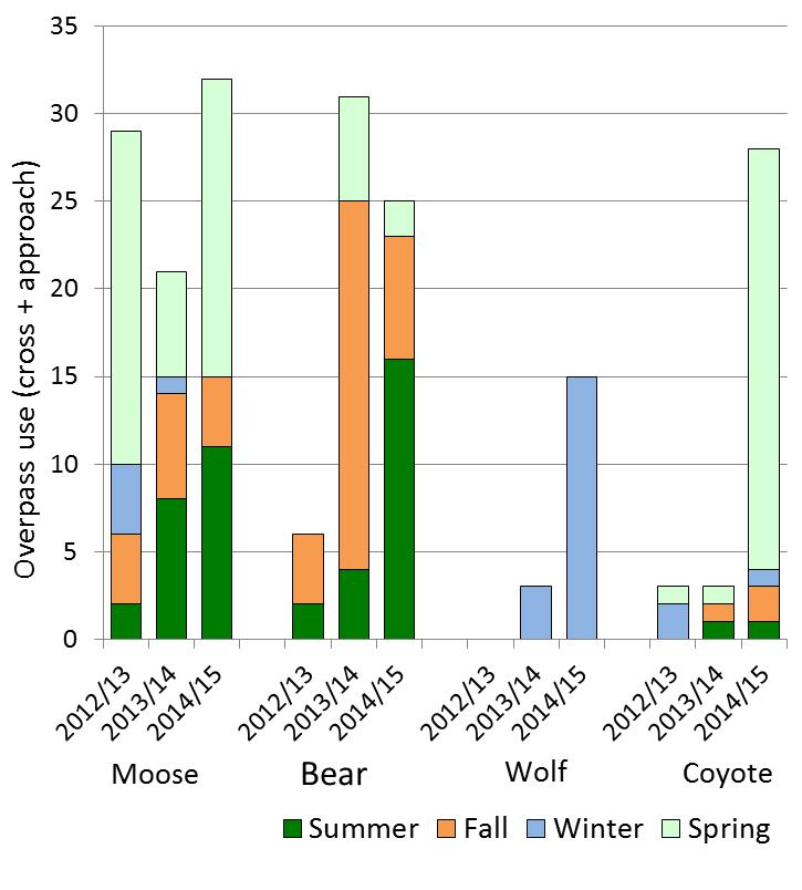
9 Kari Gunson & Andrew Healy 9 Seasonal Use Methods and Results: Camera and snow-tracking data; Post-construction data (July 1 st 2012 to July 20 th 2015). Note data was used from June 2012 to allow a full three months of data for summer in the 2012 and 2013 year. Summer (June, July, August); Fall (September, October, November); Winter (December, January, February); Spring (March, April, May). Target species: White-tailed deer (Odocoileus virginianus), Moose (Alces alces), Black bear (Ursus americanus), Wolves (Canis lycaon), Coyotes (Canis latrans) Wildlife use increased in the summer months for Moose, Bear, and Deer over the three years of monitoring; Increased Deer use in the summer is most likely due to increased forage opportunities with new vegetation growth; while decreased winter use can most likely be attributed to winter snow-fall and climate; Use of overpass increased in the winter months for Wolves over the three years of monitoring; Overall use for Deer and Moose was high in the first year of monitoring, dropped in the second year, but picked up again in the third year; Canids are using the structure more over time; Black bear use peaked in the 2013/14 year but use may have decreased in 2014/15 due to the road-kill of three adult Black bears near the wildlife overpass from October 2013 to May 2014.


10 Kari Gunson & Andrew Healy 10 FIGURE 3 Post-construction seasonal use and photo from wildlife overpass (MTO unpublished data).
11 Kari Gunson & Andrew Healy 11 Sex-Related Use Methods and Results: Camera data only; Post-construction data between June and December for 2012, 2013, and Males were classified from camera pictures that showed Deer and Moose with antlers between June and December when antlers are well-defined. Sex and age-related ratios were calculated on both the overpass and compared to camera data in the surrounding areas, i.e. cameras placed at one-way gates and access roads. Chi-squared tests (p<0.05) were used to measure whether the ratios differed between the overpass and surrounding landscape. Target species: White-tailed Deer (Odocoileus virginianus), Moose (Alces alces), On the overpass, 17 Moose were assessed and 88% were female and 12% were male (Table 2). The sex ratio between the area surrounding the overpass was not significantly different from the sex ratio of Moose using the wildlife overpass (p value >0.05). In the area surrounding the overpass there were 707 observations of Deer; 25% were male and 75% were female. Of the 495 Deer using the overpass where sex could be determined, 57% were male and 43% were female and this was significantly different than that surrounding the overpass (X 2 =266.42, d.f.=3, P<0.001; Table 2). Deer use of the overpass was sex biased towards males who used it 2.3 times more than expected. TABLE 2 Observed and (expected) overpass crossings for male and female Moose and Deer from June to December of 2012, 2013, and 2014 (Eco-Kare International 2014) Moose Deer Male Female Total Male Female Total Observed Observed Expected Expected Chi Square Chi Square P - - p>0.05 P - - p<0.001 WILDLIFE UNDERPASS One Large Box Culvert Structure Type: Twinned concrete structures 5 m wide x 5 m tall, x 24.1 m long, grass seeded on clay substrate. Monitoring: Two cameras at each entrance and one camera in middle of structure. Snow tracking completed approximately 8 times in the winter months. In addition two cameras installed along access road approaching wildlife overpass to measure observed use with expected. A Relative Abundance Index (RAI) [(number of photos*100)/(# of trap nights)] where number of trap nights is the total # of cameras multiplied by operation days, was used to standardize abundance of animals at access roads and at crossing structures and measure whether animals used the structures more than expected. Target Species: Large to medium sized animals, most specifically White-tailed deer (Odocoileus virginianus), Moose (Alces alces), Black bear (Ursus americanus), Wolves (Canis lycaon), Coyotes (Canis latrans) and Red Fox (Vulpes vulpes). Results: Camera and snow-tracking data; Post-construction data (July 1 st 2012 to July 20 th 2015).

 and photo from one large box culvert wildlife underpass (MTO")

12 Kari Gunson & Andrew Healy 12 Moose have used the underpass the most (46 times) followed by Deer (31 times) and Fox, Bear and Coyote; Moose and Deer regularly repel from the underpass more so than the other animals that used the structure, e.g. Bear and Coyote; All species with the exception of Moose, were more abundant on the underpass access road than at the underpass. Moose were two times more abundant at the underpass (RAI 4.1) than along the access road (RAI=2.04). FIGURE 4 Post-construction monitoring results (camera and snowtracking data) and photo from one large box culvert wildlife underpass (MTO unpublished data). Three Smaller Box Culverts Structure Type: Twinned concrete structures 3.4 m wide x 2.4 m high x 24.1 m long with some water flow in spring and tapering off in late summer; any standing water freezes in tunnels in winter
13 Kari Gunson & Andrew Healy 13 Monitoring: Two cameras at each entrance of two tunnels; snow tracking completed approximately 8 times in the winter months. Cameras placed approximately 1 m high on wall of structure to target large animals. Target Species: These tunnels were designed for Blanding s Turtles (Emydoidea blandingii) however were also monitored to investigate whether large to medium sized animals, most specifically White-tailed deer (Odocoileus virginianus), Moose (Alces alces), Black bear (Ursus americanus), Wolves (Canis lycaon), Coyotes (Canis latrans) and Red Fox (Vulpes vulpes) used them. Results: January 2015 to July A diversity of animals were captured using the reptile tunnel, including a Snapping Turtle; several other Snapping Turtles and Painted Turtles were documented using the tunnel as part of another study (MTO, 2015 unpublished data) Tunnels are providing some connectivity for larger animals, i.e. three Moose, two Deer, and two Wolves over one year of monitoring and are very permeable for small mammals and use by turtles (intended species) is currently being assessed.


14 Kari Gunson & Andrew Healy 14 FIGURE 5 Monitoring results from January to July 2015 (camera and snowtracking data) and photo from three smaller box culvert wildlife underpass (MTO unpublished data).
15 Kari Gunson & Andrew Healy 15 Wildlife Creek Bridge Pathway Structure Type: Two metre creek bridge pathway constructed on north side of river gorge under open bridge span; connected to rugged, rocky trails along the creek that wildlife will follow under the highway, however wildlife can also follow the river and not be captured on the cameras. Monitoring: Two cameras at each entrance and one camera on access trail approaching wildlife pathway. Snow tracking completed approximately 8 times in the winter months. Target Species: Large to medium sized animals, most specifically White-tailed deer (Odocoileus virginianus), Moose (Alces alces), Black bear (Ursus americanus), Wolves (Canis lycaon), Coyotes (Canis latrans) and Red Fox (Vulpes vulpes). Results: Camera and snow-tracking data; Post-construction data (July 1 st 2012 to July 20 th 2015). Of the larger animals Black Bears have used the structure the most (10 times); The pathway is relatively used more by mid to small animals
.")

16 Kari Gunson & Andrew Healy 16 FIGURE 6 Post-construction monitoring results (camera and snowtracking data) and photo from Lovering Creek bridge path (MTO unpublished data). CROSSING STRUCTURE COMPARISON Methods: Wildlife use and passage rate defined as: (approaches + passages/(approaches + passages + repels) was compared between species and the three crossing structures that have been monitored for three years post construction. Results: Post construction data from July 1 st, 2012 to July 20 th, 2015 Wildlife use for all species is highest at the overpass than at the other two structures, followed by the underpass and Lovering Creek wildlife pathway;
17 Kari Gunson & Andrew Healy 17 Wolves have not yet been documented using the large box culvert. TABLE 3 Wildlife use of crossing structures (overpass, underpass, Lovering Creek bridge, and reptile tunnels) from July 1st, 2012 to Jul 20 th, 2015 (MTO unpublished report). Structure Moose Deer Bear Wolf Coyote Fox Total Overpass Underpass Lovering Creek bridge Total Passage rates were highest at the overpass for all larger species; and Black Bear tend not to repel from both the underpass and overpass Moose and Deer followed a similar pattern with high passage rates close to 1 for the overpass but decreased to approximately 0.5 at the underpass and Lovering Creek bridge On average all wildlife used the three crossing structure types 84% of the time TABLE 4 Passage rate for Deer, Moose, Black bear, Wolf, Coyote, and Fox at the overpass, underpass, Lovering Creek bridge, and Reptile tunnels from July 1st, 2011 to Jul 20 th, 2015 Passage Rate Moose Deer Bear Wolf Coyote Fox Average Overpass Underpass n/a Lovering Creek bridge Average ONE WAY GATES Structure Type: Curved prong gates along fence to allow animals one-way passage from the road-side to the safe-side (26 installed in study stie) Monitoring: The number of one-way gates monitored with cameras ranged from 6 to 15 during the study period. Gates also monitored with snow tracking surveys approximately 8 times a winter season. Results: Pre and Post construction data from September 1 st, 2011 to July 20 th, 2015; only includes data obtained from animals on the road-side of the fence Black Bear have used the gates the most (6 times) followed by Deer (4 times), and Elk and Moose have not yet used the one-way gates Small mammals (Rabbits, Racoons, and Groundhogs), Lynx, and Black Bear have been documented using the gates the wrong way from safe-side to road-side on a few occasions.
.")

 and during low traffic")
18 Kari Gunson & Andrew Healy 18 FIGURE 7 Monitoring results (camera and snowtracking data) and photo from one-way gates (MTO unpublished data). Includes pre- and post-construction data from September 1 st, 2011 to July 20 th, 2015; only includes data obtained from animals on the road-side of the fence. HIGHWAY PREMEABILITY Objective: Evaluate whether animal crossing behaviour changed due to varying traffic volumes and road types Methods: Road driving surveys were conducted along Old Highway 69 during high traffic volumes ( ) and during low traffic volumes ( and ) and also along two control sections, one 5 km stretch of highway and two access roads with no traffic. When wildlife interactions with the roads were recorded the following interactions were noted (Table 1):
 Parallel if they animal tracks moved parallel with the road.")
19 Crossing rates Permeability Presence Kari Gunson & Andrew Healy 19 1) A crossing event if the animal tracks crossed the road from one side to the other, 2) An approach if the animal approached the road but did not cross it, or, 3) Parallel if they animal tracks moved parallel with the road. Results: The independent data (one count when more than one track for the same species within 300 m) used for analyses were 86 tracks (permeability analysis), 181 (presence analysis), and 101 for the crossing rate; The Old Highway 69 was most permeable for all large animals (Figure 8 top left) when traffic volumes were less than 500 vehicles per day and there were two lanes of traffic; Large animals were much more abundant and crossed the road along the access roads followed by the Old Highway 69 with two lanes and minimal traffic and than the twinned highway (Figure 8, top right and bottom left); The presence of animals that also crossed the highway were very similar when traffic volumes were diverted to the new alignment on Old Hwy 69 suggesting that one year of data may not be adequate to assess change in animal present along roads; More years of Before data would have greatly supplemented this analysis and the data should be analysed for statistical significance using a Before-After-Control-Impact Design Twinned Old Hwy 69 (before) Old Hwy 69 (after) Twinned Old Hwy 69 (before) Old Hwy 69 (after) Access Roads Twinned Old Hwy 69 (before) Old Hwy 69 (after) Access Roads
20 Kari Gunson & Andrew Healy 20 FIGURE 8. Permeability (cross / cross + approach; "top"), Presence (cross + approach + parallel / km / surveys; "middle"), and Crossing rates (crosses / length / surveys; "bottom") for all large animals for three highway types with high, moderate, low and no traffic volumes over three winter tracking seasons (Eco- Kare International, 2014) FENCING EFFECTIVENESS Structure Type: ~ 20 km continuous wire mesh fence spanning 10 km both sides of highway; 2.4 m high, steel poles; fence ends on north side tied into steep rocky highway embankments Monitoring: evaluated with two performance measures 1) fence breaches, i.e. animals on road-side of fence with cameras and snow tracking data; and 2) wildlife-vehicle collisions collected by wildlife researchers (pre Sept to October 31, 2012; post November 1, 2012 to September 1, 2014). Results: Since October 31, 2012, when the fence was complete there have been 33 breaches of the fence by Deer; There have been 11 breaches by Black Bear documented near the south and north fence ends as well as near the overpass; One fence breach has been observed for Moose just south of Killarney and Highway 69 interchange on Highway 637; and none on Highway 69; There has been a 58% decrease in collisions post fencing and no documented collisions with Moose, Elk, or Wolves have occurred along the fenced section post fencing. CONCLUSIONS The mitigation strategy in its entirety has contributed to less animals on the highway, reduced wildlife-vehicle collisions, and provided substantial permeability across the new highway alignment for mid- to large-sized mammals (Deer, Moose, Black Bears, Coyotes and Red Fox); Four years of monitoring have shown species-specific patterns of use at the three crossing structures. Ungulates (Deer and Moose) that are moving within the vicinity of both crossings are using them. Lynx are present in the vicinity of the structures but have not used the structures. Wolf use of structures is increasing and this may be related to more wolves in the area; Black Bear use is decreasing and this may be due to less bears in the area; Large ungulates tend to prefer the overpass as opposed to the underpass, but Moose are using the underpass more than expected; There are sex-related differences in use of the overpass by Deer, and more males tend to use the overpass than expected; There are seasonal differences in use of the overpass, and Moose and Deer have increasingly used the overpass more in the summer, but also use the overpass regularly in the fall and summer. A previous study has found that Moose used the overpass significantly more than expected in the spring and Deer used the overpass significantly more in the summer and fall (Eco-Kare International 2014). Animal use and movements in the winter is most likely fluctuating with snow fall and temperature; Currently, one-way gates have limited known effectiveness, and the use of the gates by animals the wrong way may negate any benefits; it may be possible to improve effectiveness with better
21 Kari Gunson & Andrew Healy 21 design. For example gates in New Brunswick have a perpendicular fence extension at the gate that may funnel and deflect animals to the gate opening; Snow tracking data has complemented evaluation of mitigation effectiveness for large animals and has provided information about passage of Deer at the one-way gate, and complemented passages of animals at crossing structures; Snow tracking data is also a useful technique for documenting fence breaches as well as evaluating the barrier effect of highways with varying traffic volumes (Eco-Kare International 2014) and results have shown that animals avoid high volume roads with 4 lanes moreso than 2 lane highways with low traffic and access roads with no traffic. Crossing structures and fencing are an optimal measure to reduce this barrier effect (Dodd et al. 2012). ACKNOWLEDGEMENTS The first three years of monitoring was funded by the Ministry of Transportation (MTO) head office, St. Catharines and Jennifer Wittig managed all financial and contractual obligations. The fourth and fifth years of monitoring were funded by a MTO retainer fund. Andrew Healy in MTO Northeastern Region, has managed all progress meetings, provided technical information and helped facilitate many logistical components of this project. A special thank-you to all the interns, graduate students, and field technicians for their assistance with field data collections, namely W. Kowbasniuk and S. Boyle. Special thank-you to Dr. Josef Hamr, D. McGeachy and W. Kowbasniuk that provided quality assurance for species identifications from camera and track data. Dr. J. Hamr also reported the majority of the wildlife-vehicle collisions. W. Carrigan managed the camera set-up and maintenance, as well as picture processing and management. D. McGeachy, contributed to the study design, data collections and analytical support for this report. Dr. David Lesbarrères assisted in providing logistical support, reviewing progress, as well as expertise on genetics analyses. Dr. Mike Sawaya provided advisement on field set up for collecting bear genetic samples in the field and relating these data to research questions. Norris Dodd provided quality assurance in preliminary field study designs. At the time of writing, The Ministry of Transportation has confirmed an additional one year of funding for effectiveness monitoring on Highway 69, monitoring data will be compiled over a five year time period in BIOGRAPHICAL SKETCHES Kari Gunson is a self-employed road ecologist with 16 years of expertise with planning for and monitoring road-wildlife mitigation measures for both large and small animals in Ontario and elsewhere. Her work has led to over 16 peer-reviewed papers and five book chapters in the field of road ecology and Geographic Information Science. Andrew Healy is a Senior Environmental Planner with the Ontario Ministry of Transportation. Since 2007, Andrew has been the chair of Northeastern Region s Wildlife Mitigation Team, and has been directly involved with the design, implementation and monitoring of various collision mitigation measures, including the province s first wildlife crossings and wildlife detection systems. Through this work Andrew has advanced the practice of wildlife mitigation in Ontario and is currently working towards the development of provincial standards.
22 Kari Gunson & Andrew Healy 22 REFERENCES Clevenger, A. P., and M. Barrueto, editors Trans-Canada Highway Wildlife and Monitoring Research, Final Report. Part B: Research. Prepared for Parks Canada Agency, Radium Hot Springs, British Columbia. Clevenger, A. P., and M. P. Huijser Handbook for design and evaluation of wildlife crossing structures in North America. Prepared by the Western Transportation Institute for the Federal Highway Administration. 212 pages, Washington, D.C. Clevenger, A. P., and N. Waltho Factors influencing the effectiveness of wildlife underpasses in Banff National Park, Alberta, Canada. Conservation Biology 14: Dodd, N. L., J. W. Gagnon, S. C. Sprague, S. Boe, and R. E. Schweinsburg Wildlife accident reduction study and monitoring: Arizona State Route 64. Final report 626. Prepared for the Arizona Department of Transportation in coorperation with the US Department of Transportation, Federal Highway Administration. Eco-Kare International Monitoring effectiveness of large mammal mitigation measures: Highway 69 between Sudbury and Parry Sound. 92 pages. Final report submitted to the Ministry of Transportation, Northeastern Region, North Bay, Ontario. Gagnon, J. W., N. L. Dodd, K. S. Ogren, and R. E. Schweinsburg Factors associated with use of wildlife underpasses and importance of long-term monitoring. The Journal of Wildlife Management 75: Huijser, M. P., A. V. Kociolek, T. D. H. Allen, P. T. McGowen, P. C. Cramer, and M. Venner Construction guidelines for wildlife fencing and associated escape and lateral access control measures. Prepared for the American Association of State Highway and Transportation Officials (AASHTO) Standing Committee on the Environment. 218 pages, Washington, D.C. Huijser, M. P., A. Kociolek, P. McGowen, A. Hardy, A. P. Clevenger, and R. Ament Wildlifevehicle collision and Crossing mitigation measures: A Toolbox for the Montana Department of Transportation. No. FHWA/MT / Montana Department of Transportation.
MPC-432 January 1, December 31, 2013
 MPC-43 January 1, 013- December 31, 013 Project Title: Finding Innovative Solutions to Prevent Wildlife Access to Highways at Wildlife Guards University: Utah State University Principal Investigators:
APPENDIX 1. Cost Estimates for Mitigation Measures
 APPENDIX 1. Cost Estimates for Mitigation Measures We estimated the cost of the mitigation measures listed in Table 1 based on a review of the literature and interviews with researchers, manufacturers,
Wildlife Crossings: A Solution for Moose Vehicle Collisions in Alaska
 Wildlife Crossings: A Solution for Moose Vehicle Collisions in Alaska M elchisedek Jean & Katy Wright April 8, 2017 Prepared for: Dr. Protasel PADM A628: Public Financial M anagement Statement of Need
Jeff Gagnon Norris Dodd Sue Boe. Scott Sprague Ray Schweinsburg Arizona Game and Fish Department
 EVALUATION OF AN ANIMAL ACTIVATED ACTIVATED HIGHWAY CROSSWALK INTEGRATED WITH RETROFIT FENCING Jeff Gagnon Norris Dodd Sue Boe Kari Ogren Scott Sprague Ray Schweinsburg Arizona Game and Fish Department
Evaluation of Wildlife Mitigation Measures,
 Evaluation of Wildlife Mitigation Measures, US93 Evaro-Polson: Preconstruction Monitoring and Research Results Marcel Huijser, Amanda Hardy, Julie Fuller, Angela Kociolek, Meredith Evans, Pat McGowen September
EXECUTIVE SUMMARY. Banff Wildlife Crossings Project:
 EXECUTIVE Banff Wildlife Crossings Project: SUMMARY Integrating science and education in restoring population connectivity across transportation corridors. A report prepared for: Parks Canada Agency Box
DEER AND ELK POPULATION STATUS AND HARVEST STRUCTURE IN WESTERN NORTH AMERICA: A SUMMARY OF STATE AND PROVINCIAL STATUS SURVEYS.
 DEER AND ELK POPULATION STATUS AND HARVEST STRUCTURE IN WESTERN NORTH AMERICA: A SUMMARY OF STATE AND PROVINCIAL STATUS SURVEYS. JUSTIN BINFET,' Wyoming Game and Fish Department, 5400 Bishop Boulevard,
Wildlife Vehicle Collision Study
 Wildlife Vehicle Collision Study HIGHWAY 3 SCIENCE WORKSHOP FERNIE, B.C. January 28-29, 2008 Rob Ament Road Ecology Program Manager Western Transportation Institute Wildlife Vehicle Collision Reduction
2010 Wildlife Management Unit 510 moose
 2010 Wildlife Management Unit 510 moose Photo: Shevenell Webb Section Authors: Kristina Norstrom and Shevenell Webb Suggested Citation: Norstrom, K., and S. Webb. 2010. Wildlife Management Unit 510 moose.
White-tailed Deer: A Review of the 2010 Provincially Coordinated Hunting Regulation
 Population Estimate White-tailed Deer: A Review of the 21 Provincially Coordinated Hunting Regulation White-tailed deer in BC were managed using a combination of General Open Season (GOS) and Limited Entry
Ecological gains through EIA in Parks Canada
 Ecological gains through EIA in Parks Canada Eric Tremblay, Park Ecologist, Kouchibouguac National Park, NB, Canada April 6 th, 2017 1 Integrating SARA and Fisheries Act Aboriginal consultations 2 Kouchibouguac
Wildlife Use of Highway Underpass Structures in Washington State
 1 3 7 9 1 11 1 13 1 1 1 17 1 19 1 3 7 9 3 31 3 33 3 3 3 37 3 39 1 3 7 9 1 3 Wildlife Use of Highway Underpass Structures in Washington State Hailey Starr, Habitat Connectivity Research Intern Washington
Copyright 2018 by Jamie L. Sandberg
 Copyright 2018 by Jamie L. Sandberg All rights reserved. This book or any portion thereof may not be reproduced or used in any manner whatsoever without the express written permission of the publisher,
H8 Signs, Supports and Poles
 Alberta Infrastructure and Transportation Roadside Design Guide November 2007 H8 Signs, Supports and Poles H8.1 Introduction This section identifies the appropriate roadside safety treatment for signs,
PREDATOR CONTROL AND DEER MANAGEMENT: AN EAST TEXAS PERSPECTIVE
 PREDATOR CONTROL AND DEER MANAGEMENT: AN EAST TEXAS PERSPECTIVE BEN H. KOERTH, Institute for White-tailed Deer Management and Research, Box 6109, Arthur Temple College of Forestry, Stephen F. Austin State
CHAPTER 20 WILDLIFE CROSSINGS
 CHAPTER 20 WILDLIFE CROSSINGS 20.0 INTRODUCTION The linear nature of surface transportation systems creates a suite of concerns for transportation and natural resource management agencies as they seek
Iroquoia Heights Conservation Area White-tailed Deer Management Strategy
 Iroquoia Heights Conservation Area White-tailed Deer Management Strategy Public Engagement Workshops May 31 st and June 1 st, 2011 Hosted by Hamilton Conservation Authority (HCA) and the Deer Management
Frequently Asked Questions Reintroduction of Bison to Banff National Park
 Frequently Asked Questions Reintroduction of Bison to Banff National Park Background For thousands of years, vast herds of plains bison roamed the prairies and the eastern slopes of the Continental Divide,
Enhancing Connectivity
 Recommendations for Enhancing Connectivity for Terrestrial and Aquatic Wildlife along the I-70 Mountain Corridor CONTENTS Recommendations for Terrestrial Connectivityy LIZ-2011 LIZ A: Dotsero LIZ B: Wolcott
PLACEMENT OF SIGNS RECOMMENDED PRACTICES SUB-SECTION
 Page 1 of 6 RECOMMENDED PRACTICES PART SECTION SUB-SECTION HIGHWAY SIGNS GENERAL General Proper positioning of signs is an important element in the overall control of traffic within a roadway network.
DESIGN RECOMMENDATIONS FROM FIVE YEARS OF WILDLIFE CROSSING RESEARCH ACROSS UTAH
 Proceedings of the 2013 International Conference on Ecology and Transportation (ICOET 2013) DESIGN RECOMMENDATIONS FROM FIVE YEARS OF WILDLIFE CROSSING RESEARCH ACROSS UTAH Patricia Cramer, (435-764-1995,
ALTERNATIVE WORKSHOP JULY
 WELCOME - ALTERNATIVE WORKSHOP JULY 27, 2017 MEETING GOALS ITD is committed to working collaboratively with stakeholders to ensure safe and efficient mobility through Island Park and Targhee Pass. TONIGHT
COUNTY ROAD 22 HORSESHOE VALLEY ROAD. Municipal Class Environmental Assessment. simcoe.ca
 OCTOBER 2014 Municipal Class Environmental Assessment COUNTY ROAD 22 HORSESHOE VALLEY ROAD Project A Truck Climbing Lanes Project B Intersection Improvements simcoe.ca CORPORATE COMMUNICATIONS DEPARTMENT
#!! "$% ##! &! # '#! % $ #!
 Executive Summary US Highway 16 (US 16) is the primary corridor connecting Rapid City to the Black Hills region. It serves a growing population of commercial and residential traffic, as well as seasonal
MoPac South: Impact on Cesar Chavez Street and the Downtown Network
 MoPac South: Impact on Cesar Chavez Street and the Downtown Network Prepared by: The University of Texas at Austin Center for Transportation Research Prepared for: Central Texas Regional Mobility Authority
Terwillegar Drive Expressway Draft Concept Plan
 Terwillegar Drive Expressway Draft Concept Plan Anthony Henday Drive to Whitemud Drive November 28 5:00-8:00 p.m. December 1 10:00 a.m. - 3:00 p.m. Let s Talk Today you can: Learn about the new direction
Appendix T CCMP TRAIL TRAFFIC & TRANSPORTATION DESIGN STANDARD
 Appendix T CCMP 3.3.4 TRAIL TRAFFIC & TRANSPORTATION DESIGN STANDARD 3.3.4 Trail Traffic and Transportation Design Multi-use trails have certain design standards, which vary depending on the agency that
Design Criteria. Design Criteria
 F Design Criteria Design Criteria Ministry of Transportation Ministère des Transports DESIGN CRITERIA Page: 1 of 13 WORK PROJECT NO. N/A GO Bloomington Station TYPE OF PROJECT LOCATION Bloomington Road
AN INCIDENTAL TAKE PLAN FOR CANADA LYNX AND MINNESOTA S TRAPPING PROGRAM
 349 AN INCIDENTAL TAKE PLAN FOR CANADA LYNX AND MINNESOTA S TRAPPING PROGRAM Glenn D. DelGiudice, Michael DonCarlos, and John Erb SUMMARY A Habitat Conservation Plan (HCP) has been developed in association
Competition. Competition. Competition. Competition. Competition. Competition. Competition. Long history in ecology
 Two species use the same limited resource or harm one another while seeking a resource Resource Organisms use common resources that are in short supply Resource Interference Interference Organisms seeking
MONITORING WILDLIFE-VEHICLE COLLISIONS: ANALYSIS AND COST- BENEFIT OF ESCAPE RAMPS FOR DEER AND ELK ON U.S. HIGHWAY 550
 Applied Research and Innovation Branch MONITORING WILDLIFE-VEHICLE COLLISIONS: ANALYSIS AND COST- BENEFIT OF ESCAPE RAMPS FOR DEER AND ELK ON U.S. HIGHWAY 550 Jeremy L. Siemers, Kenneth R. Wilson, and
Evaluation of Measures to Reduce Wildlife-Vehicle Collisions and Promote Connectivity in a Sonoran Desert Environment State Route 77
 Progress Report Evaluation of Measures to Reduce Wildlife-Vehicle Collisions and Promote Connectivity in a Sonoran Desert Environment State Route 77 Santa Catalina Tortolita Mountain Corridor Presented
Project No.: Contract No. Key Words: wildlife crossings, highway underpasses, large mammals, white-tailed deer, black bear, deervehicle
 Standard Title Page - Report on State Project Report No. Report Date No. Pages Type Report: Final VTRC 06-R2 August 2005 37 Period Covered: June 2004-May 2005 Title: The Use of Highway Underpasses by Large
Review of Considerations and Requirements for Automated Enforcement
 Review of Considerations and Requirements for Automated Enforcement Summary: The purpose of this report is to provide information related to expanding the use of automated enforcement in the City of Toronto,
White-Tailed Deer Management FAQ
 December 6 th, 217 Ministry of Forests, Lands, Natural Resource Operations and Rural Development White-Tailed Deer Management FAQ What are current white-tailed deer management objectives in the Kootenay
Monitoring Population Trends of White-tailed Deer in Minnesota Marrett Grund, Farmland Wildlife Populations and Research Group
 Monitoring Population Trends of White-tailed Deer in Minnesota - 2014 Marrett Grund, Farmland Wildlife Populations and Research Group INTRODUCTION White-tailed deer (Odocoileus virginianus) represent one
2010 Wildlife Management Unit 501 moose and deer
 2010 Wildlife Management Unit 501 moose and deer Section Authors: Barb Maile and Velma Hudson Suggested Citation: Maile, B., and V. Hudson. 2010. Wildlife Management Unit 501 moose and deer. Pages 73 77.
Mitigating Vehicle Collisions with Large Wildlife
 Mitigating Vehicle Collisions with Large Wildlife Internet Amanda Shearin, Wildlife Biologist/Habitat Outreach Coordinator - Augusta Standing in for Chuck Hulsey, Regional Wildlife Biologist - Strong Maine
Job Title: Game Management, Subsection B Game Management Mountain Lion
 Job Title:, Subsection B Goal: Manage the mountain lion population, its numbers and distribution, as an important part of Arizona s fauna and to provide mountain lion hunting recreation opportunity while
Twinning Hwy 11/17 Thunder Bay to Nipigon
 Twinning Hwy 11/17 Thunder Bay to Nipigon 55 th Annual Engineering and Technology Conference Lakehead Chapter PEO November 4, 2016 Presented by: Bruce Caldwell, P. Eng., MBA Manager Program Planning Ministry
WEST AND SOUTH WEST RING ROAD DOWNSTREAM TRAFFIC IMPACTS
 Page 1 of 9 EXECUTIVE SUMMARY Alberta Transportation ( AT ) is preparing to construct the final sections of the Calgary Ring Road. This includes the South West Ring Road ( SWRR ) (from Lott Creek Blvd
Job Title: Game Management, Subsection B Game Management Mountain Lion. SPECIES: Mountain Lion
 SPECIES: Goal: Manage the mountain lion population, its numbers and distribution, as an important part of Arizona s fauna and to provide mountain lion hunting recreation opportunity while maintaining existing
Current Travel Needs and Operating Conditions (See pages 4 9 of the Discussion Guide)
") Phase 1 Consultation: Understanding the Need Feedback Form Thank you for participating in this phase of planning for the George Massey Tunnel Replacement. Your feedback is important to us. Input received
Phase 1 Consultation: Understanding the Need Feedback Form Thank you for participating in this phase of planning for the George Massey Tunnel Replacement. Your feedback is important to us. Input received
Job Title: Game Management, Subsection B Game Management Mountain Lion. SPECIES: Mountain Lion
 SPECIES: Goal: Manage the mountain lion population, its numbers and distribution, as an important part of Arizona s fauna and to provide mountain lion hunting recreation opportunity while maintaining existing
Memorandum. Exhibit 60 SSDP To: Jenny Bailey, Senior Planner. From: Bill Schultheiss, P.E. (WA. P.E. #46108) Date: June 20, 2017
 Date: June 20, 2017") Memorandum To: Jenny Bailey, Senior Planner From: Bill Schultheiss, P.E. (WA. P.E. #46108) Date: June 20, 2017 Re: East Lake Sammamish Trail, Segment 2B Review King County has asked Toole Design Group
Memorandum To: Jenny Bailey, Senior Planner From: Bill Schultheiss, P.E. (WA. P.E. #46108) Date: June 20, 2017 Re: East Lake Sammamish Trail, Segment 2B Review King County has asked Toole Design Group
YELLOWSTONE NATIONAL PARK, UNITED STATES
 YELLOWSTONE NATIONAL PARK, UNITED STATES Date - December 2008 Duration - 15 Days Destinations Yellowstone National Park and environs. Trip Overview This was primarily a research trip to try out a UK company
Study Terrestrial Furbearer Abundance and Habitat Use
 Initial Study Report Meeting Study 10.10 Terrestrial Furbearer Abundance and Habitat Use October 21, 2014 Prepared by Institute of Arctic Biology, University of Alaska Fairbanks 10/21/2014 1 Study 10.10
Findings and Guidelines Wednesday, March 12, 2003 Page 1
 Findings and Guidelines Wednesday, March 12, 2003 Page 1 Findings of the Board of Game and Guidelines for a Unit 19D East Predation Control Program March 12, 2003 I. Overview Of Project Development And
Wildlife Hazard Mitigation Policy, Plan and Procedure. May
 Wildlife Hazard Mitigation Policy, Plan and Procedure May - 2010 I. POLICY: The Wildlife Hazard Mitigation Plan will identify both short and long term strategies for mitigating the hazard that certain
Fish Passage Design Aids Wildlife Crossing in Washington State State of the Practice
 Fish Passage Design Aids Wildlife Crossing in Washington State State of the Practice 0 Submission date: November, 0 Word Count:, Jon Peterson, corresponding author (0-0-, peterjn@wsdot.wa.gov) Fish Passage
BOZEMAN PASS WILDLIFE PRE-AND POST-FENCE MONITORING PROJECT. April C. Craighead 1. Frank L. Craighead 2. Lauren Oechsli 3
 BOZEMAN PASS WILDLIFE PRE-AND POST-FENCE MONITORING PROJECT April C. Craighead 1 Frank L. Craighead 2 Lauren Oechsli 3 1 Craighead Environmental Research Institute, 201 South Wallace Avenue, Suite B2D,
MOUNTAIN CARIBOU INTERACTIONS WITH WOLVES AND MOOSE IN CENTRAL BRITISH COLUMBIA
 MOUNTAIN CARIBOU INTERACTIONS WITH WOLVES AND MOOSE IN CENTRAL BRITISH COLUMBIA Dale R. Seip British Columbia Ministry of Forests and Range, 1011 Fourth Ave., Prince George, B.C. V2L 3H9, Canada, e-mail:
Active Transportation Infrastructure Investment A Business Case
 Active Transportation Infrastructure Investment A Business Case In 2016, the Real Estate Foundation awarded the Capital Regional District a $50,000 grant for Shifting Gears: Land Use Change through Active
DMU 038 Jackson County
 DMU 038 Jackson County Area Description The Jackson Deer Management Unit (DMU), or DMU 038, lies in the Southern Lower Peninsula (SLP) region and covers Jackson County. The DMU consists of five percent
REBOUND. on the. It was the winter of 2000/2001, and it seemed like the snow
 JILLIAN COOPER / istockphoto.com 12 January / February 2018 on the While concerns remain, American marten are making a comeback in New Hampshire REBOUND by Jillian Kilborn It was the winter of 2000/2001,
Ministry of Forests, Lands and Natural Resource Operations
 For Immediate Release 2015FLNR0004-000035 January 15, 2015 INFORMATION BULLETIN Government acting to save endangered caribou VICTORIA - The Ministry of Forests, Lands and Natural Resource Operations is
Subject: Scoping Comments Ochoco Summit OHV Trail Project
 Bill Richardson Oregon & Washington Lands Program Manager Rocky Mountain Elk Foundation 24550 Ervin Road Philomath OR 97370 866-399-6089 office 541-760-5083 cell brichardson@rmef.org December 21, 2009
Peace Region Wildlife Regulations Proposed Changes for Comment ( )
") Peace Region Wildlife Regulations Proposed Changes for Comment (2010-11) INTRODUCTION This document summarizes changes to hunting regulations currently under consideration in the Peace Region. These changes,
Peace Region Wildlife Regulations Proposed Changes for Comment (2010-11) INTRODUCTION This document summarizes changes to hunting regulations currently under consideration in the Peace Region. These changes,
Deer and Bison Artiodactyla
 Deer and Bison Artiodactyla Moose: Linda Shaw 100 Wapiti Cervus elaphus When Europeans first settled Canada, the eastern race of Wapiti or Elk (C. e. canadensis) were found in the Rainy River area and
STATE OF MINNESOTA IN COURT OF APPEALS. Court File No. A Petitioners, Respondents.
 STATE OF MINNESOTA IN COURT OF APPEALS Court File No. A12-1680 Center for Biological Diversity, Howling for Wolves, Petitioners, vs. AFFIDAVIT OF JOHN D. ERB Minnesota Department of Natural Resources,
Alberta Highway 881. Corridor Management Plan. Session Forum 1 - Highways. Tri-Party Transportation Conference Moving Alberta Into the Future
 Tri-Party Transportation Conference Moving Alberta Into the Future Alberta Highway 881 Corridor Management Plan Lac La Biche to Anzac Session Forum 1 - Highways March 2017 INTRODUCTION + 241 km long, 2
2. THAT the Mayor and Corporate Officer be authorized to execute all documents related to this matter.
 COUNCIL REPORT Report No. PRC 016-2016 EXECUTIVE COMMITTEE Date: March 2, 2016 File No: 6240-01 To: From: Subject: Mayor and Council Heidi Enns, General Manager, Parks, Recreation and Culture BikeBC Program
To position power poles a safe distance from the road to minimise the likelihood of being accidentally hit by vehicles.
 Policy Statement Subject Placement of Rigid Distribution Poles Along Roads With Speed Limits Exceeding 70KM/H Approved by Robert Rogerson Signature & Date Distribution Standards and Policy Manager Authorised
General Design Factors
 Chapter 3: 3-1.0 Introduction General Design Factors Mn/DOT s goals include encouraging and accommodating safe bicycling. From a design perspective, these goals are achieved by first having an understanding
Appendix A: Crosswalk Policy
 Appendix A: Crosswalk Policy Appendix A: Crosswalk Policy Introduction This citywide Crosswalk Policy is aimed at improving pedestrian safety and enhancing pedestrian mobility by providing a framework
Population Ecology Yellowstone Elk by C. John Graves
 Population Ecology Yellowstone Elk by C. John Graves Group Names: Hour Date: Date Assignment is due: end of class Score: + - Day of Week Date Rocky Mountain elk (Cervus elaphus) living in Yellowstone National
Post impact trajectory of vehicles at rural intersections
 Post impact trajectory of vehicles at rural intersections Doecke SD., Woolley JE. and Mackenzie JR. Centre for Automotive Safety Research Abstract This report describes the path of vehicles after a collision
Life history Food Distribution Management... 98
 BEAR: Table of Contents Overview Life history... 97 Food... 97 Distribution... 98 Management... 98 2010 Statistical Reports Controlled spring bear season harvest... 100 General season black bear harvest...
Questionnaire for Aboriginal Traditional Knowledge Interviews on Boreal Caribou LONG VERSION
 ANNEX 1 Annex 1 Questionnaire for Aboriginal Traditional Knowledge Interviews on Boreal Caribou LONG VERSION The following questions have been developed to gain information and understanding related to
Conservation Planning in Vermont
 Conservation Planning in Vermont Today s outline 1. A primer on conservation biology 2. VT Wildlife Action Plan 3. How VTRANS & Fish and Wildlife work together 4. Discussion: How can we better work together?
VGI for mapping change in bike ridership
 VGI for mapping change in bike ridership D. Boss 1, T.A. Nelson* 2 and M. Winters 3 1 Unviersity of Victoria, Victoria, Canada 2 Arizona State University, Arizona, USA 3 Simon Frasier University, Vancouver,
Northern Yellowstone Cooperative Wildlife Working Group 2012 Annual Report (October 1, 2012-September 30, 2012) Member Agencies
 Member Agencies") Northern Yellowstone Cooperative Wildlife Working Group 2012 Annual Report (October 1, 2012-September 30, 2012) Member Agencies Montana Fish, Wildlife & Parks National Park Service, Yellowstone National
Northern Yellowstone Cooperative Wildlife Working Group 2012 Annual Report (October 1, 2012-September 30, 2012) Member Agencies Montana Fish, Wildlife & Parks National Park Service, Yellowstone National
make people aware of the department s actions for improving the deer population monitoring system,
 Investing in Wisconsin s Whitetails 1 Over the last 60 years, the department has developed a deer herd monitoring and management system that seeks to use the best science and data possible. The deer monitoring
Alberta Infrastructure HIGHWAY GEOMETRIC DESIGN GUIDE AUGUST 1999
 Alberta Infrastructure HIGHWAY GEOMETRIC DESIGN GUIDE AUGUST 1999,1'(; A ACCELERATION Data on acceleration from stop D-29 Effects of grade D-35 Intersections D-97, D-99 Lanes D-97, F-5, F-7, F-15, F-21,
Welcome to the Open House
 Leslie Street Between 19 th Avenue and Stouffville Road Addendum to Class Environmental Assessment Study Welcome to the Open House Please sign in at the front desk. March 28, 2017 Richmond Green Sports
EXECUTIVE SUMMARY OF CALEDON TRANSPORTATION NEEDS STUDY
 EXECUTIVE SUMMARY OF CALEDON TRANSPORTATION NEEDS STUDY The Caledon Transportation Needs Study has been undertaken as a joint project by the Town of Caledon and the Region of Peel to determine the existing
Ecology and Environmental Impact of Javan Rusa Deer (Cervus timorensis russa) in the Royal National Park
 in the Royal National Park") Ecology and Environmental Impact of Javan Rusa Deer (Cervus timorensis russa) in the Royal National Park Andrew James Moriarty B. App. Sc. (Hons.) A thesis submitted in fulfillment of the requirements
Ecology and Environmental Impact of Javan Rusa Deer (Cervus timorensis russa) in the Royal National Park Andrew James Moriarty B. App. Sc. (Hons.) A thesis submitted in fulfillment of the requirements
Traffic Management Guidelines for Structure Rehabilitation Projects
 , Traffic Management Guidelines for Structure Rehabilitation Projects February 2009 1 Purpose & Background These guidelines were prepared in order to assist the Regional Structural Office in determining
Roundabouts along Rural Arterials in South Africa
 Krogscheepers & Watters 0 0 Word count: 00 text + figures = 0 equivalent words including Title and Abstract. Roundabouts along Rural Arterials in South Africa Prepared for: rd Annual Meeting of Transportation
2008 WMU 359 moose, mule deer, and white tailed deer
 2008 WMU 359 moose, mule deer, and white tailed deer Section Authors: Dave Stepnisky and Robb Stavne Suggested citation: Stepnisky, D. and R. Stavne. 2009. WMU 359 moose, mule deer, and white tailed deer.
April Nisga a Fisheries & Wildlife Department
 April 2013 Nisga a Fisheries & Wildlife Department Nass Wildlife Committee created by the Nisga a Final Agreement Only wildlife co-management body in B.C. First Nass Wildlife Management Plan 2001 Annual
Michigan Predator-Prey Project Phase 1 Preliminary Results and Management Recommendations. Study Background
 Michigan Predator-Prey Project Phase 1 Preliminary Results and Management Recommendations Study Background White-tailed deer are important ecologically, socially, and economically throughout their geographic
Washington St. Corridor Study
 FIGURE 7.17 Bridge Alternatives - Cross Sections 86 Discarded Alternative: Short-Term Bridge Repair Short-term repairs and west bridge span replacement were considered during analysis. Short-term repairs
WELCOME TO OPEN HOUSE # 1 June 14, 2017
 Langstaff Road Weston Road to Highway 7 Class Environmental Assessment Study WELCOME TO OPEN HOUSE # 1 June 14, 2017 Please sign in and join our mailing list Purpose of Open House #1 & Study Area York
CITY OF WEST LAKE HILLS. Forest View Neighborhood Traffic Calming Study
 CITY OF WEST LAKE HILLS 901 South Mopac Expressway Building V, Suite 220 Austin, Texas 78746 Texas P.E. Firm Registration No. F-929 Klotz Associates Final Report Submittal: March 20, 2015 Revised Final
Job Title: Game Management, Subsection B Game Management Mountain Lion. SPECIES: Mountain Lion
 SPECIES: Goal: Manage the mountain lion population, its numbers and distribution, as an important part of Arizona s fauna and to provide mountain lion hunting recreation opportunity while maintaining existing
Deer Management Unit 152
 Deer Management Unit 152 Geographic Location: Deer Management Unit (DMU) 152 is 386 miles 2 in size and is primarily in southwestern Marquette County. This DMU falls within the moderate snowfall zone and
Management of Canada Geese
 Management of Canada Geese Erika Lok, Canadian Wildlife Service Union of BC Municipalities Convention - Urban Wildlife Workshop September 27, 2011 Historical and current distribution of southern breeding
USDA APHIS WILDLIFE SERVICES ACTIVITIES SUMMARY REPORT 2013 WHITE-TAILED DEER MANAGEMENT PROGRAM TOWNSHIP OF UPPER ST. CLAIR (September 2013)
") USDA APHIS WILDLIFE SERVICES ACTIVITIES SUMMARY REPORT 2013 WHITE-TAILED DEER MANAGEMENT PROGRAM TOWNSHIP OF UPPER ST. CLAIR (September 2013) USDA APHIS Wildlife Services (WS) was requested by the Township
USDA APHIS WILDLIFE SERVICES ACTIVITIES SUMMARY REPORT 2013 WHITE-TAILED DEER MANAGEMENT PROGRAM TOWNSHIP OF UPPER ST. CLAIR (September 2013) USDA APHIS Wildlife Services (WS) was requested by the Township
ROADWAY LIGHTING Literature Summary
 ROADWAY LIGHTING There have been a number of studies done about the effect of roadway lighting, but little research has focused on its deer-vehicle crash (DVC)-reduction potential. Most DVCs occur in the
2008 WMU 360 moose, white tailed deer and mule deer. Section Authors: Robb Stavne, Dave Stepnisky and Mark Heckbert
 2008 WMU 360 moose, white tailed deer and mule deer Section Authors: Robb Stavne, Dave Stepnisky and Mark Heckbert Suggested citation: Stavne, R., D. Stepnisky, and M. Heckbert. 2009. WMU 360 moose, white
TRAFFIC IMPACT STUDY CRITERIA
 Chapter 6 - TRAFFIC IMPACT STUDY CRITERIA 6.1 GENERAL PROVISIONS 6.1.1. Purpose: The purpose of this document is to outline a standard format for preparing a traffic impact study in the City of Steamboat
M-58 HIGHWAY ACCESS MANAGEMENT STUDY Mullen Road to Bel-Ray Boulevard. Prepared for CITY OF BELTON. May 2016
 M-58 HIGHWAY ACCESS MANAGEMENT STUDY Prepared for CITY OF BELTON By May 2016 Introduction Missouri State Highway 58 (M-58 Highway) is a major commercial corridor in the City of Belton. As development has
DRAFT. A fifth objective, other considerations, has been added to capture considerations not captured by the four primary objectives.
 TECHNICAL MEMORANDUM Albany - Washington Avenue Traffic Calming Evaluation Matrix of Conceptual Alternatives Date: May 17, 2017 Project #: 17356 To: Aleida Andrino-Chavez From: Laurence Lewis, Sara Muse,
United States Department of the Interior
 United States Department of the Interior FISH AND WILDLIFE SERVICE Virginia Ecological Services Field Office 6669 SHORT LANE GLOUCESTER, VA 23061 PHONE: (804)693-6694 FAX: (804)693-9032 URL: www.fws.gov/northeast/virginiafield/
MUTCD Part 6G: Type of Temporary Traffic Control Zone Activities
 MUTCD Part 6G: Type of Temporary Traffic Control Zone Activities 6G.01 Typical Applications Each temporary traffic control (TTC) zone is different. Many variables, such as location of work, highway type,
Highway 1 Kamloops to Alberta Four-Laning Program
 Highway 1 Kamloops to Alberta Four-Laning Program COMMUNITY ENGAGEMENT DISCUSSION GUIDE AND FEEDBACK FORM February 7 March 1, 2013 www.bchwy1.ca 1 FEEDBACK FORM INSIDE HOW INPUT WILL BE CONSIDERED FAST
Traffic Data Needs for National Parks
 Traffic Data Needs for National Parks by Patrick McGowen Research Engineer Western Transportation Institute College of Engineering Montana State University A report prepared for the CLR Analytics For Small
1 Monash University Accident Research Centre, Monash University, Victoria, RACV, 550 Princes Highway Noble Park, Victoria, 3174.
 Roadside Environment Safety: a statistical analysis of collisions with fixed roadside objects in Victoria Amanda Delaney 1, Stuart Newstead 1, Bruce Corben 1, Jim Langford 1 and Peter Daly 2 1 Monash University
Toronto Complete Streets Guidelines
 88 90 5.1 Cycling Design Principles 92 5.2 Context-sensitive Cycling Facilities 96 5.3 Key Cycling Elements Cycling infrastructure provides choice in how people are able to move around the city. Cyclists