ROUTEING MEASURES AND MANDATORY SHIP REPORTING SYSTEMS
|
|
|
- Brian Cunningham
- 5 years ago
- Views:
Transcription


1 E SUB-COMMITTEE ON NAVIGATION, COMMUNICATIONS AND SEARCH AND RESCUE 6th session Agenda item 3 NCSR 6/3/3 12 October 2018 Original: ENGLISH ROUTEING MEASURES AND MANDATORY SHIP REPORTING SYSTEMS Establishment of a new traffic separation scheme and associated routeing measures in the Sunda Strait, Indonesia Submitted by Indonesia SUMMARY Executive summary: Strategic direction, if applicable: This document contains a proposal to establish a traffic separation scheme (TSS) in the Sunda Strait for enabling separation of the two streams of routes by using a separation zone. A precautionary area with recommended directions of traffic flow and inshore traffic zones is also provided for managing the intersection of shipping lanes in the Sunda Strait. All of these proposed routeing measures are aimed to minimize the risk of collision between ships as well as grounding on the existing Koliot Reefs located in the Sunda Strait. Other work Output: OW 4 Action to be taken: Paragraph 54 Related documents: SOLAS regulation V/10, resolutions A.572(14), as amended; MSC.71(69); MSC 72(69); SN/Circ.206; MSC.1/Circ.1060, as amended; and UNCLOS 1982, part IV and NCSR 6/INF.19 Introduction 1 This document contains a proposal by Indonesia to establish an IMO-adopted traffic separation scheme (TSS) that includes one precautionary area and two inshore traffic zones in the Sunda Strait located between Sumatera Island and Java Island in Indonesia.
2 Page 2 2 Details of the proposed TSS, precautionary area and inshore traffic zones are provided as follows: Summary.1 description of the TSS and inshore traffic zones, including the name, number, edition and geodetic datum of the reference chart as well as the geographical coordinates that define them, are provided in annex 1;.2 chartlet showing proposed routeing measures is provided in annex 2;.3 description of the proposed precautionary area with recommended directions of traffic flow, including the name, number, edition and geodetic datum of the reference chart as well as the geographical coordinates that define them are provided in annex 3;.4 detailed chartlet of the proposed routeing measures is provided in annex 4; and.5 the existing visual aids to navigation in the area are provided in annex 5. 3 The proposal aims to establish a new TSS, a precautionary area and inshore traffic zones in the Sunda Strait which are located within Sumatera Island and Java Island as shown in figures 1 to 3. 4 The objectives of establishing the proposed TSS with one precautionary area and inshore traffic zones are to:.1 reduce the number of head-on situations to increase the safety of navigation by separating opposing traffic streams in the area;.2 reduce, if not eliminate, the risk of accidental ship grounding by keeping ships well away from the coral reef atolls of Terumbu Koliot;.3 reduce, if not eliminate, the risk of collision between ships by recommending one precautionary area; and.4 ensure that ships follow the routes that are absolutely free from the known dangers posed by the coral reef atolls of Terumbu Koliot by AToN. 5 The proposed ship's routeing measures can be seen in figure 4 followed by details of each routeing measure: NM wide TSS separated by 0.3 NM wide separation zone, which lies between northern entrance of TSS and proposed precautionary area. The total length of the TSS is approximately 2.6 NM that lies between the southern bound and proposed precaution area (see Figure 4);.2 a precautionary area with recommended directions of traffic flow located within the proposed TSS, approximately 2.67 NM from the northern entrance of TSS to about 1.2 NM to the south (see Figure 4);
; and.")
3 Page NM wide TSS in the Sunda Strait that lies between the proposed precautionary areas and the southern entrance and acts as a main shipping lane at the southern entrance of the Sunda Strait. The total length of the proposed southern TSS is approximately 4 NM (see figures 3 and 4); and.4 inshore traffic zones that lie from TSS to the east coast of Sumatera Island and west coast of Java Island (see Figure 4). 6 The demonstrated need to establish the TSS with a precautionary area is to ensure that all ships are well informed of the existing potential of collision due to crossing traffic from Merak Port in Java Island to Bakauheni Port in Sumatera Island. Hence, the established TSS would likely reduce ship collisions on the route by providing a separation zone and a precautionary area for the intersection routes. Figure 1: Location of the Sunda Strait

4 Page 4 Figure 2: Map of the Sunda Strait

5 Page 5 Figure 3: Map of southern side of the Sunda Strait

6 Page 6 Figure 4: Chartlet of the proposed TSS and associated routeing measures in the Sunda Strait


7 Page 7 Figure 5: Copy of chart showing the proposed TSS and associated routeing measures in the Sunda Strait

8 Page 8 7 The reason of the TSS being preferred is because this system provides an area for separation of the two opposing streams of the shipping lane. The separation zone is aimed at increasing the safety of ship navigation in the route and reducing the probability of head-on ships' collisions. The TSS which is effective for giving adequate sea separation area is controlling the two-way traffic route and keeping the ships in the right track. 8 The TSS is proposed to establish clear ship navigation courses. This is used as guidance to assist ships to navigate safely so they can avoid approaching the shallow water and the Koliot Reef. The reef exists near the traffic lane and can potentially cause groundings. 9 The TSS has one precautionary area to prevent collisions in the intersection area of the route. The precautionary area enables the ship's master to have more awareness so the risk of collision is minimized. In addition, the risk of ship grounding could be reduced since the proposed TSS will provide more time for the responsible ship to give aid to the drifting ship. This is to prevent additional damage to the reef as well as to the ship itself since the ship could be assisted before the impact occurs. 10 As mentioned previously, the new routeing measures are proposed in order to increase the safety of ship navigation in the route, to prevent the collision in the intersection area of the route, as well as to prevent the occurrence of ship grounding by avoiding ships approaching the shallow water, particularly the Koliot Reef. Based on history, there have been several incidents involving collisions between ships and groundings in the Sunda Strait. 11 On 26 September 2012, a collision occurred involving Singapore registered gas tanker MT Norgas Cathinka that was passing thesunda Strait and Indonesia-registered ro-ro passenger ferry MV Bahuga Jaya that was crossing the Sunda Strait on the way from Java island to Sumatera island. Figure 6 shows the passage way of MT Norgas Canthinka, the position before collision and the structure condition of MT Norgas Canthinka after collision. Figure 6: Collision between MT Norgas Canthinka and MV Bahuga Jaya in 2012


9 Page 9 12 In 2014, a collision occurred involving a passenger ship and a general cargo ship. The passenger ship was sailing across the Sunda Strait while the general cargo ship passed the Sunda Strait. The damage caused by the collision is shown figure 7. The density of passenger ships crossing the Sunda Strait is very high (covering 77.4% of the total traffic density in the Sunda Strait). This means there is the potential for a collision with ships passing the Sunda Strait. Figure 7: Impact of collision on the hull of passenger ship after collided with general cargo ship in In 2015, a containership MV Hanjin Aqua (IMO No ) was grounded to Koilot Reef (Terumbu Kailot). Figure 8 shows the passage way of the MV Hanjin Aqua, the grounded position and the container transfer activity before she was pulled out from the reef. Figure 8: Grounding of a containership MV Hanjin Aqua to Koliot Reefs in The proposed system is recommended for use by all ships, whether national or foreign flagged, navigating to and from the Sunda Strait.
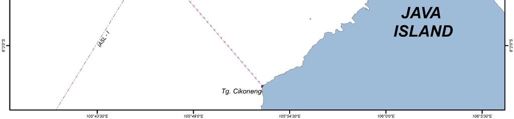
 that stipulates the rules of ships navigating in or near a TSS. 16 After the adoption of Archipelagic Sea Lanes in 1998 (resolution MSC.")
10 Page It is expected that ships using the TSS and associated routeing measures will comply with rule 10 of the Convention on the International Regulations for Preventing Collisions at Sea, 1972 (COLREG) that stipulates the rules of ships navigating in or near a TSS. 16 After the adoption of Archipelagic Sea Lanes in 1998 (resolution MSC.72(69)), ships exercising the right of archipelagic sea lane passage in Archipelagic Sea Lane I have been using the lane as a primary route between coordinate I-12 to I-14. Referring to Indonesian Nautical Chart No. 170 second edition of June 2018, based on WGS 84 datum, the coordinates are (see figure 9):.1 Coordinate I-12: 05 o 15'.00 S, 106 o 12'.50 E;.2 Coordinate I-13: 05 o 57'.25 S, 105 o 46'.33 E; and.3 Coordinate I-14: 06 o 18'.50 S, 105 o 33'.25 E. Figure 9: Point I-12 to I-14 of the Indonesia Archipelagic Sea Lane I 17 The proposed TSS will still be using the axis line of the Archipelagic Sea Lane (ASL) I as the separation line or the centre of the separation zone. The proposed scheme will not materially alter the way ships navigate in the area. There will be no increase in typical voyage distances for ships on voyages from Indonesia to ports in other countries. 18 A risk analysis of ship collision has been conducted for the proposed ship routeing measures. The analysis was done by using the methodology mentioned in figure 10.
11 Page 11 Figure 10: Methodology of risk analysis of ship collision 19 The model of the proposed routeing measures was simulated by using IWRAP (IALA Waterways Risk Assessment Program) which is shown in figure 11. The inputted data is the data of the traffic density, metocean data, bathymetry data, conservation area and ports data. The ship traffic density used in the model is the data for the next 20 years until The traffic density is assumed to increase by 2% annually during this period. The model of IWRAP comprises LEG and WAY POINT in order to input the data and simulate the collision frequency based on the type, number, size and speed of ship. The model of IWRAP shows the annual frequency of ship collisions. There are five types of collision to be analysed in this model, namely head-on, crossing, overtaking, bend and merging collisions. The result of IWRAP simulation can be seen in table 1. The result shows that the total frequency of ship collision in the proposed routeing measures for the next 20 years is (less than one event of ship collision). In comparison, if the simulation is conducted for existing shipping lane (without TSS and other routeing measures), the total annual frequency of ship collision by implementing proposed TSS and other routeing measures can be reduced about 27%.

12 Page 12 Figure 11: Model of the ship traffic using IWRAP
13 Collision Type w/o Proposed Routeing Measures Annual Frequency Collision NCSR 6/3/3 Page 13 With Proposed Routeing Measures Head-on collision Crossing collision Overtaking collision Bend collision Merging collision Total annual frequency Table 1: Annual frequency of collision without and with proposed routeing measures 20 Indonesia seeks IMO's approval and adoption for the TSS, one precautionary area with recommended directions of traffic flow and inshore traffic zones in the area of the Sunda Strait. Description of the area 21 The Sunda Strait lies between Java Island and Sumatera Island (see figure 1). This Strait connects the Indian Ocean and the Java Sea. The Sunda Strait is one of the most important straits in Indonesia. This strait has been used as a primary route since it was adopted as the Archipelagic Sea Lane (ASL) I in 1998 (resolution MSC.72(69)) where ships exercise the right of ASL passage on their voyages through the Sunda Strait from southbound to northbound and vice versa. Along with the existence of ASL I in the Sunda Strait, there is also a high density crossing traffic line oscillate Java Island and Sumatera Island that cuts ASL I. This crossing traffic is mainly occupied by passenger ferry ro-ro as well as other merchant ships. Figures 9 and 11 in addition to figures 1 to 3 show the location map of the Sunda Strait and adopted ASL I, while figures 12 and 13 show the chartlet of the Sunda Strait.

14 Page 14 Figure 12: Reference chart of the Sunda Strait (Southern Part)

15 Page 15 Figure 13: Reference chart of the Sunda Strait (Northern Part) 22 The bathymetry of the Sunda Strait has a variation of depth. It includes angular subbasin and steep slopes that the formation is controlled by faulting which makes the contour of bathymetry much more complex. The western part bathymetry of the Sunda Strait is constructed of an array of four main ridges. The ridges are the Semangko Horst, the Tabuan, Panaitan and Krakatau Ridges; and also two pronounced grabens: the Semangko Graben and the Krakatau Graben. The depth of Semangko Graben varies from less than 800 to 1,500 m, while the bathymetry of Krakatau Graben is relatively flat caused by abundance of volcanic deposition since the Krakatau Volcano is located in this area. There is also the Koliot Reef which is located approximately 1 NM northeast of the centreline of IASL I. The Koliot Reef is a coral reef which is located in the northwest of Sangiang Island in the Sunda Strait. Koliot Reefs will potentially increase the event of groundings for the ships that pass through the IASL I and go to the Indian Ocean from the Java Sea and vice versa. 23 Based on the Indonesian Hydro-Oceanography chart number 170, July 2018 edition, the Sunda Strait also contains flora and fauna nature reserve areas such as Sangiang Island, Panaitan Island and Ujung Kulon (Java Island). The waters around Krakatau Island, Krakatau Kecil Island, and Sertung Island are declared as dangerous areas because there could be a hazardous eruption at any time since these are active volcanic areas which had the biggest eruption in history.

16 Page There is one inshore lane that has been proposed for the reason that there is a lot of coastal traffic in the eastern bound and western bound of the Sunda Strait. Cooperation between States 25 This proposal has been developed solely by Indonesia. The TSS, precautionary area and inshore traffic zones are proposed to be adopted in the Sunda Strait between Sumatera and Java Islands, and between the Java Sea and the Indian Ocean. 26 The Indonesian Government had conducted communication and consultation with the stakeholders which concerned with the existence of the route namely government agencies, shipping companies, shipowners, port managements and ship operator associations. Traffic considerations 27 According to the Indonesian Law Number 6 Year 1996 on Indonesian Waters and Government Regulation Number 37 Year 2002 on Rights and Obligations of Foreign Ship and Aircraft Exercising Archipelagic Sea Lanes Passage in Designated Archipelagic Sea Lanes, the Sunda Strait is designated as Indonesian Archipelagic Sea Lane (IASL) I. This Strait serves as a domestic and international sea lane and is also crossed by ferries between Java and Sumatera Islands. The IASL was also adopted by IMO through resolution MSC.72(69) in Indonesia as the Archipelagic State has the right to prescribe the TSS to enhance the safety of navigation, based on Article 53(6) of the United Nations Convention on the Law of the Sea (UNCLOS) 1982 and also based on the General Provisions for the Adoption, Designation and Substitution of Archipelagic Sea Lanes. The designation of the TSS will not affect the rights of Archipelagic Sea Lane Passage in the Sunda Strait. 29 According to AIS data provided by the traffic patterns in the Sunda Strait are given in figures 14 and 15. The traffic pattern shows that ASL I has been used as reference of voyage in the Sunda Strait by international shipping. The traffic pattern also shows the existence of crossing traffic from Java Island in the east to Sumatera Island on the west side and vice versa. The existence of an industrial area in Cilegon (Java Island) also affects the density of ship traffic to this area which is shown with the traffic pattern towards the east side water area of Sangiang Island. Figure 14: Traffic pattern in the Sunda Strait (1)

17 Page 17 Figure 15: Traffic pattern in the Sunda Strait (2) 30 There are also existing visual aids to navigation in the area of the proposed TSS. The detail of the name as well as the location of the visual aids is shown in annex There were 53,068 ship voyages made through the area of the Sunda Strait in This translates to about 145 ships per day. Of these, 77.4% were passenger ships, 8.7% were cargo ships, 7.6% were tankers, 2.6% were tugboats, offshore supply vessels and AHTS, 1.7% were barge and landing crafts and 1.9% others (chips, bitumen, woods, cements, vehicles, livestock, urea, carriers, researches, fishing, sailing ships, etc.). 32 There is fluctuation in the shipping activity near the Sunda Strait. The fluctuation is caused by two main shipping routes which intersect in the middle of the Sunda Strait. An international shipping route which lies on the north-south bound intersects with a national shipping route which lies on the east-west bound of the Sunda Strait. The international shipping route is fluctuated by the transportation of commodities between southeast, east Asia and middle Asia countries to Australia. While the national shipping route is fluctuated by the crossing of shipping routes between Port of Merak, Port of Tanjung Priok, Port of Bakauheni and other ports in the district of Banten. Ship traffic density between these routes is likely to grow since the Indonesian Government is speeding up Indonesia maritime development by proposing a sea highway.

18 Page 18 Figure 16: Number of ships passing through the Sunda Strait in The Indonesian Naval Hydrographic and Oceanographic Centre conducted hydrographic surveys in the Sunda Strait in 2004, 2007, 2008, 2011 and 2016:.1 The last hydrographic survey conducted in 2017 was based on WGS84 datum. The survey was conducted using GPS Trimble Net R5, Trimble Net R9, and Trimble SPS 855 equipped with Zephyr Geodetic 2 antennas for positioning. The area was 100% covered by multi-beam echo-sounder in 2012; maximum error is less than 10 cm with a confidence level of 95%. The depths in the area vary from 30 m to 100 m..2 The proposed TSS area is clear from navigational hazard. Uncharted features hazardous to surface navigation are not expected but may exist, so the area is designated as Zone of Confidence (ZOC) B..3 The area is covered by Electronic Navigational Chart (ENC) in scale of 1:200,000 and nautical chart in scale up to 1:25,000 that was updated in All charts are in metric units and based on WGS84 datum.


19 Page 19 Figure 17: Bathymetry in the Sunda Strait 34 The proposed scheme has been designed to follow the IASL I (existing traffic pattern) as closely as possible, as well as to consider the record of ship navigation pattern obtained from AIS data in the Sunda Strait. Course alterations, convergence areas and route junctions have been kept to a minimum. 35 There are no offshore structures such as drilling rigs or exploration platforms located in or near the proposed TSS. 36 There is no existing hydrocarbon exploration or exploitation activities planned in the vicinity of the proposed TSS. Marine environmental considerations 37 The eastern tropical Indian Ocean including the Sunda Strait is greatly influenced by the Australian-Indonesian monsoon system. These two monsoon systems are seasonally reversing monsoon winds which dynamically impact the ocean currents along the southern part of Java and Sumatera sea water. The northwest monsoon season occurs between December and February. Wind flows from the Eurasian continent, past the South China Sea and the Bay of Bengal. During this season, the wind carries warm and moist air to Indonesia. The southeast monsoon season happens between June and September. During this time south-easterly winds blow from Australia and carry warm and dry air to Indonesia.
20 Page Inside the Sunda Strait, there is an exchange of water mass between the Java Sea and the Indian Ocean. In general, the mass of water moves towards the Indian Ocean because the water level in the Java Sea is higher than that in the Indian Ocean. The Java Sea and the South China Sea are the source of low-salinity water masses. Runoff from major rivers of Sumatera, Kalimantan and Java affects more salinity than rainfall, while the mass of the Indian Ocean water is characterized by high salinity due to the mass of water from the Red Sea and Persian Gulf. 39 The presence of the Koliot Reef located close to the shipping lane poses a potential hazard to the safety of navigation of ships passing through ASL I, especially the occurrence of ship grounding to the Koliot Reef. The Koliot Reef is located at coordinates of 5 55'.00 S and '.17 E. The Indonesian Government has established Aids to Navigation as a presence of the reef, with details as follows:.1 AtoN name : West Cardinal Light Beacon.2 Coordinate : 05 55'.29 S, '.84 E Status of routeing systems 40 As an IMO adopted TSS, all vessels will be subject to the provision of rule 10 of COLREG If a vessel fails to comply with the measures on a designated ship routeing system, appropriate actions will be taken, including interaction with the flag State, in accordance with relevant IMO regulations. 42 The proposed TSS can be reasonably expected to reduce the risk of collision, reduce and delay the risk of pollution or other harm to the marine environment.

21 Page 21 Figure 18: Location of the Koliot Reef
22 Page 22 Position-fixing in relation to the routeing system 43 There are existing visual aids to navigation in the area of the proposed TSS and other ships' routeing measures. The detail of the name as well as the location of the visual aids is shown in annex The installation of virtual AtoN will be determined in accordance with IMO and IALA guidelines regarding virtual AtoN. The installation of the said virtual AToN will be conducted prior to the implementation of the measures in the Sunda Strait upon adoption. 45 The proposed TSS, precautionary area and inshore traffic zones are within coverage of the fully operational AIS base stations. 46 There are AIS base stations operated by the Indonesian Government which are able to reach the AIS signal from ships located in the area, namely VTS Merak, VTS Jakarta and VTS Center Panjang. These AIS base stations recognize all the ships located in the TSS as well as the ships which are out of TSS. By using VTS, the Indonesian Government will give services to all ships in order to ensure the safe passage of ships. Every effort will be made to ensure ships out of TSS maintain their voyage in the right track. 47 There are VTS services available within the proposed TSS, precautionary area and inshore traffic zones and ships are expected to participate using the said services. Miscellaneous information 48 There are no fishing grounds in the area of the proposed TSS. 49 According to Ministerial Decree of the Ministry of Forestry of Indonesia No. 55/Kpts-II/1993, Sangiang Island which is located in vicinity of ASL I has been designated as a Marine Nature Park. 50 There are no foreseeable changes in the traffic patterns stemming from ports or any other related developments. 51 Extensive consultation has taken place with user States and stakeholders including other local interested parties. 52 The Indonesian Government conducted the international Workshop on the proposal of the Designation traffic separation scheme (TSS) in Lombok and the Sunda Strait that took place in Bali on 9 April 2018 and was attended by the representatives of user States, the shipping industry and other stakeholders. The objectives were to update the information on the proposal of the designation of TSS in Lombok and the Sunda Strait as well as to enhance the awareness of the user States and stakeholders on the said proposals. Proposed date of implementation 53 It is proposed that the TSS and associated routeing measures will enter into force six months after adoption by the Maritime Safety Committee. Action requested of the Sub-Committee 54 The Sub-Committee is invited to consider the proposal and recommend it to the Maritime Safety Committee for adoption. ***
23 Annex 1, page 1 ANNEX 1 DESCRIPTION OF THE PROPOSED TRAFFIC SEPARATION SCHEME AND INSHORE TRAFFIC ZONES (Reference chart: Indonesian Nautical Chart No. 170, second edition of June Note: This chart is based on World Geodetic System 1984 datum (WGS84)). Description of the traffic separation scheme (a) A separation zone, 0.3 mile wide, is centred upon the following geographical positions: (1) 05 49'.06 S '.58 E (2) 05 48'.89 S '.31 E (3) 05 51'.17 S '.89 E (4) 05 51'.34 S '.16 E (b) A traffic lane for northeast bound traffic is established between the separation zone in (a) and a line connecting the following geographical positions: (5) 05 49'.66 S '.54 E (6) 05 51'.94 S '.13 E (c) A traffic lane for southwest bound traffic is established between the separation zone in (a) and a line connecting the following geographical positions: (7) 05 50'.57 S '.92 E (8) 05 48'.30 S '.35 E (d) A separation line connects the following geographic positions: (9) 05 53'.65 S '.56 E (10) 05 57'.04 S '.46 E (e) A traffic lane for northeast bound traffic is established between the separation line in (d) and a line connecting the following geographical positions: (11) 05 53'.97 S '.09 E (12) 05 57'.36 S '.98 E (f) A traffic lane for southwest bound traffic is established between the separation line in (d) and a line connecting the following geographical positions: (13) 05 56'.72 S '.95 E (14) 05 53'.34 S '.06 E
24 Annex 1, page 2 Inshore traffic zones (g) Eastern inshore traffic zone The area between the traffic separation scheme from position (5) to Pujut Point (05 52'.56 S, '.47 E) with direction 106, and a line drawn from position (12) to Cikoneng Point ( S, E) with direction 139 is designated as an inshore traffic zone. (h) Western inshore traffic zone The area between the traffic separation scheme from position (8) to Kanggalan Point ( S, E) with direction 288, and a line drawn from position (13) to Tua Point ( S, E) with direction 307 is designated as an inshore traffic zone. ***


25 Annex 2, page 1 ANNEX 2 CHARTLET OF THE TRAFFIC SEPARATION SCHEME AND INSHORE TRAFFIC ZONE IN THE SUNDA STRAIT ***
26
.")
27 Annex 3, page 1 ANNEX 3 DESCRIPTION OF THE PROPOSED PRECAUTIONARY AREA WITH RECOMMENDED DIRECTIONS OF TRAFFIC FLOW IN THE SUNDA STRAIT (Reference chart: Indonesian Nautical Chart No. 170 second edition of June Note: This chart is based on World Geodetic System 1984 datum (WGS84).) Precautionary area with recommended directions of traffic flow A precautionary area with recommended directions of traffic flow, as described in the chartlet below, is established bounded by a line joining the following geographical positions: (15) 05 51'.94 S '.13 E (16) 05 50'.57 S '.92 E (17) 05 53'.34 S '.06 E (18) 05 53'.97 S '.09 E Chartlet: Precautionary area with recommended directions of traffic flow ***
28

29 Annex 4, page 1 ANNEX 4 DETAILED CHARTLET OF PROPOSED TSS AND ASSOCIATED ROUTEING MEASURES IN THE SUNDA STRAIT

30 Annex 4, page 2 ***
31 Annex 5, page 1 ANNEX 5 EXISTING NAVIGATION AIDS (LIGHTS) The name as well as the location of the existing visual aids to navigation in the area of the proposed TSS are listed in detail, as follows: I. Main AtoN (shown in the chartlet) No AtoN Position Latitude Longitude Range 1 Cikoneng Lighthouse 06 04'.00 S '.00 E 19 NM 2 Tanjung Tua Light Beacon 05 54'.37 S '.00 E 12 NM 3 Sangiang Light Beacon 05 58'.33 S '.13 E 16 NM 4 Pulau Ular Light Beacon 06 00'.55 S '.57 E 13 NM 5 Koliot Reef Light Beacon 05 55'.29 S '.84 E 12 NM 6 Pulau Panjurit Light Beacon 05 53'.12 S '.12 E 18 NM 7 Serdang Light Beacon 05 57'.01 S '.83 E 21 NM 8 Merak Besar Light Beacon 05 56'.08 S '.53 E 12 NM 9 Tempurung Lighthouse 05 54'.01 S '.88 E 13 NM II. Secondary AtoN 1 Sebeku beacon light 05 51'.00 S '.00 E 11 NM 2 Pulau Rakata beacon light 06 09'.74 S '.53 E 12 NM 3 Pulau Tiga beacon light 05 49'.17 S '.54 E 13 NM 4 Pasir Brower buoy light 05 56'.74 S '.80 E 5 NM 5 Karang Ayer Serdang beacon light 05 59'.23 S '.50 E 12 NM Chartlet of the main Navigation Aids in the Sunda Strait
ROUTEING MEASURES AND MANDATORY SHIP REPORTING SYSTEMS
 E SUB-COMMITTEE ON NAVIGATION, COMMUNICATIONS AND SEARCH AND RESCUE 5th session Agenda item 3 NCSR 5/INF.24 15 December 2017 ENGLISH ONLY ROUTEING MEASURES AND MANDATORY SHIP REPORTING SYSTEMS Information
IMPLEMENTATION OF TRAFFIC SEPARATION SCHEME FOR PREVENTING ACCIDENTS ON THE SUNDA STRAIT
 International Journal of Technology (2015) 6: 990-997 ISSN 2086-9614 IJTech 2015 IMPLEMENTATION OF TRAFFIC SEPARATION SCHEME FOR PREVENTING ACCIDENTS ON THE SUNDA STRAIT Sunaryo 1*, Antoni Arif Priadi
ROUTEING MEASURES OTHER THAN TRAFFIC SEPARATION SCHEMES
 E 4 ALBERT EMBANKMENT LONDON SE1 7SR Telephone: +44 (0)20 7735 7611 Fax: +44 (0)20 7587 3210 SN.1/Circ.317 4 December 2012 ROUTEING MEASURES OTHER THAN TRAFFIC SEPARATION SCHEMES 1 The Maritime Safety
ROUTEING MEASURES AND MANDATORY SHIP REPORTING SYSTEMS
 E SUB-COMMITTEE ON NAVIGATION, COMMUNICATIONS AND SEARCH AND RESCUE 5th session Agenda item 3 NCSR 5/INF.23 15 December 2017 ENGLISH ONLY ROUTEING MEASURES AND MANDATORY SHIP REPORTING SYSTEMS Information
III Code. TRACECA Maritime Safety and Security IMSAS workshop Kiev (Ukraine) III Code. Dr. Jens U. Schröder-Hinrichs
 III Code. Dr. Jens U. Schröder-Hinrichs") III Code III Code III Code TRACECA Maritime Safety and Security IMSAS workshop Kiev (Ukraine) Dr. Jens U. Schröder-Hinrichs IMSAS workshop Kiev Agenda 1 2 3 4 5 6 7 8 9 Introduction Background to IMSAS
III Code III Code III Code TRACECA Maritime Safety and Security IMSAS workshop Kiev (Ukraine) Dr. Jens U. Schröder-Hinrichs IMSAS workshop Kiev Agenda 1 2 3 4 5 6 7 8 9 Introduction Background to IMSAS
International regulations and guidelines for maritime spatial planning related to safe distances to multiple offshore structures (e.g.
 International regulations and guidelines for maritime spatial planning related to safe distances to multiple offshore structures (e.g. wind farms) Introduction This is a summary of the most important international
World Shipping Council. National Oceanographic and Atmospheric Administration
 Comments of the World Shipping Council Submitted to the National Oceanographic and Atmospheric Administration In the matter of Endangered and Threatened Species; Petition for Rulemaking to Establish a
SAFE PASSAGE THE STRAITS OF MALACCA AND SINGAPORE. CF6-6.7.a the 6 th Co-Operation Forum 7-8 October 2013, Bali, Indonesia DRAFT CONTENT TEXT
 CF6-6.7.a the 6 th Co-Operation Forum 7-8 October 2013, Bali, Indonesia DRAFT CONTENT TEXT VER. 24 September 2013 SAFE PASSAGE THE STRAITS OF MALACCA AND SINGAPORE 1 INTRODUCTION Today, the Straits of
Study Proposal for the Batu Berhenti Light Buoy
 Study Proposal for the Batu Berhenti Light Buoy Malacca Strait Council The 17 th Aids to Navigation Fund Committee meeting 22 23 September 2016, Singapore 1 Contents 1. About Batu Berhanti Light Buoy 2.
RESOLUTION MEPC.136(53) Adopted on 22 July 2005 DESIGNATION OF THE BALTIC SEA AREA AS A PARTICULARLY SENSITIVE SEA AREA
 Adopted on 22 July 2005 DESIGNATION OF THE BALTIC SEA AREA AS A PARTICULARLY SENSITIVE SEA AREA") MEPC 53/24/Add.2 RESOLUTION MEPC.136(53) THE MARINE ENVIRONMENT PROTECTION COMMITTEE, BEING AWARE of the ecological, social, economic, cultural, scientific and educational value of the Baltic Sea Area,
MEPC 53/24/Add.2 RESOLUTION MEPC.136(53) THE MARINE ENVIRONMENT PROTECTION COMMITTEE, BEING AWARE of the ecological, social, economic, cultural, scientific and educational value of the Baltic Sea Area,
RESOLUTION MSC.161(78) (adopted on 17 May 2004) AMENDMENTS TO THE EXISTING MANDATORY SHIP REPORTING SYSTEM "THE TORRES STRAIT AND INNER ROUTE OF THE
 (adopted on 17 May 2004) AMENDMENTS TO THE EXISTING MANDATORY SHIP REPORTING SYSTEM THE TORRES STRAIT AND INNER ROUTE OF THE") MSC 78/26/Add.2 RESOLUTION MSC.161(78) REPORTING SYSTEM THE TORRES STRAIT AND INNER ROUTE OF THE GREAT BARRIER REEF THE MARITIME SAFETY COMMITTEE, RECALLING Article 28(b) of the Convention on the International
MSC 78/26/Add.2 RESOLUTION MSC.161(78) REPORTING SYSTEM THE TORRES STRAIT AND INNER ROUTE OF THE GREAT BARRIER REEF THE MARITIME SAFETY COMMITTEE, RECALLING Article 28(b) of the Convention on the International
PROJECT 1 REMOVAL OF WRECKS IN THE TRAFFIC SEPARATION SCHEME IN THE STRAITS OF MALACCA AND SINGAPORE OBJECTIVE. Generally to enhance the safety of
 PROJECT 1 REMOVAL OF WRECKS IN THE TRAFFIC SEPARATION SCHEME IN THE STRAITS OF MALACCA AND SINGAPORE OBJECTIVE Generally to enhance the safety of navigation in the Straits of Malacca and Singapore (Straits)
IMO ROUTEING OF SHIPS, SHIP REPORTING AND RELATED MATTERS
 INTERNATIONAL MARITIME ORGANIZATION E IMO SUB-COMMITTEE ON SAFETY OF NAVIGATION 52nd session Agenda item 3 NAV 52/3/9 13 April 2006 Original: ENGLISH ROUTEING OF SHIPS, SHIP REPORTING AND RELATED MATTERS
SOLAS requirements for nonpassenger ships 300 or above but less than 500 gross tonnage
 SOLAS requirements for nonpassenger ships 300 or above but less than 500 gross tonnage Guidance for owners, masters and surveyors for ships undertaking international voyages SOLAS requirements applied
AWARENESS ON HIGH RISK SITUATION OF BATU BERHANTI LIGHT BUOY IN SINGAPORE STRAIT (assure sustainable isolated danger marking)
") DIRECTORATE GENERAL OF SEA TRANSPORTATION MINISTRY OF TRANSPORTATION REPUBLIC OF INDONESIA AWARENESS ON HIGH RISK SITUATION OF BATU BERHANTI LIGHT BUOY IN SINGAPORE STRAIT (assure sustainable isolated
DIRECTORATE GENERAL OF SEA TRANSPORTATION MINISTRY OF TRANSPORTATION REPUBLIC OF INDONESIA AWARENESS ON HIGH RISK SITUATION OF BATU BERHANTI LIGHT BUOY IN SINGAPORE STRAIT (assure sustainable isolated
NEW AND AMENDED EXISTING TRAFFIC SEPARATION SCHEMES
 INTERNATIONAL MARITIME ORGANIZATION 4 ALBERT EMBANKMENT LONDON SE1 7SR Telephone: 020 7587 3152 Fax: 020 7587 3210 IMO E Ref. T2-OSSHE/2.7.1 COLREG.2/Circ.57 26 May 2006 NEW AND AMENDED EXISTING TRAFFIC
Maritime Rules Part 25: Nautical Charts and Publications
 Maritime Rules Part 25: Nautical Charts and Publications ISBN 978-0-478-44797-2 Published by Maritime New Zealand, PO Box 25620, Wellington 6146, New Zealand Maritime New Zealand Copyright 2015 Part 25:
Norwegian Coastal Administration (NCA) HSSC November 2015 Busan - Republic of Korea
 HSSC November 2015 Busan - Republic of Korea") Norwegian Coastal Administration (NCA) HSSC7 9-13 November 2015 Busan - Republic of Korea Requirements relating to sector lights for Electronic Navigational Chart (ENC) Product Specifications B E Krosness
Norwegian Coastal Administration (NCA) HSSC7 9-13 November 2015 Busan - Republic of Korea Requirements relating to sector lights for Electronic Navigational Chart (ENC) Product Specifications B E Krosness
The Maritime Law Association of Australia and New Zealand
 The Maritime Law Association of Australia and New Zealand Protecting the Environment and Promoting Safe Navigation: Australia s System of Pilotage in the Torres Strait Adam McCarthy Assistant Secretary
World Shipping Council. Bureau of Ocean Energy Management Department of the Interior
 Comments of the World Shipping Council Submitted to the Bureau of Ocean Energy Management Department of the Interior In the matter of Commercial Leasing for Wind Power Development on the Outer Continental
NEW AND AMENDED TRAFFIC SEPARATION SCHEMES
 INTERNATIONAL MARITIME ORGANIZATION 4 ALBERT EMBANKMENT LONDON SE1 7SR Telephone: 020 7587 3152 Fax: 020 7587 3210 IMO E Ref. T2-OSSHE/2.7.1 COLREG.2/Circ.56 6 December 2005 NEW AND AMENDED TRAFFIC SEPARATION
properly applied assessment in the use.1 landmarks.1 approved in-service of ECDIS is not experience The primary method of fixing required for those
 STCW Code Table A-II/3 Specification of minimum standard of for officers in charge of a navigational watch and for masters on ships of less than 500 gross tonnage engaged on near-coastal voyages Ref: https://www.edumaritime.net/stcw-code
RESOLUTION A.817(19) adopted on 23 November 1995 PERFORMANCE STANDARDS FOR ELECTRONIC CHART DISPLAY AND INFORMATION SYSTEMS (ECDIS)
 adopted on 23 November 1995 PERFORMANCE STANDARDS FOR ELECTRONIC CHART DISPLAY AND INFORMATION SYSTEMS (ECDIS)") A 19/Res.817 15 December 1996 Original: ENGLISH ASSEMBLY 19th session Agenda item 10 RESOLUTION A.817(19) adopted on 23 November 1995 PERFORMANCE STANDARDS FOR ELECTRONIC CHART DISPLAY AND INFORMATION
A 19/Res.817 15 December 1996 Original: ENGLISH ASSEMBLY 19th session Agenda item 10 RESOLUTION A.817(19) adopted on 23 November 1995 PERFORMANCE STANDARDS FOR ELECTRONIC CHART DISPLAY AND INFORMATION
PERFORMANCE STANDARDS FOR ELECTRONIC CHART DISPLAY AND INFORMATION SYSTEMS (ECDIS) [IMO Resolutions A.817 (19), MSC.64 (67) and MSC.
 [IMO Resolutions A.817 (19), MSC.64 (67) and MSC.") 1 PERFORMANCE STANDARDS FOR ELECTRONIC CHART DISPLAY AND INFORMATION SYSTEMS (ECDIS) [IMO Resolutions A.817 (19), MSC.64 (67) and MSC.86 (70)] (amended March 1999) Note: The IMO Performance Standards for
1 PERFORMANCE STANDARDS FOR ELECTRONIC CHART DISPLAY AND INFORMATION SYSTEMS (ECDIS) [IMO Resolutions A.817 (19), MSC.64 (67) and MSC.86 (70)] (amended March 1999) Note: The IMO Performance Standards for
S-44 edition 5 The IHO s New Standard For Hydrographic Surveys Chris Howlett Head of Seabed Data Centre United Kingdom Hydrographic Office
 S-44 edition 5 The IHO s New Standard For Hydrographic Surveys Chris Howlett Head of Seabed Data Centre United Kingdom Hydrographic Office Chairman of IHO Working Group that created S-44 edition 5 S-44
THE REPUBLIC OF LIBERIA LIBERIA MARITIME AUTHORITY
 Office of Deputy Commissioner of Maritime Affairs THE REPUBLIC OF LIBERIA LIBERIA MARITIME AUTHORITY Marine Notice NAV-003 Rev. 06/12 TO: SUBJECT: ALL SHIPOWNERS, OPERATORS, MASTERS AND OFFICERS OF MERCHANT
SHIP DESIGN AND EQUIPMENT
 E MARITIME SAFETY COMMITTEE 92nd session Agenda item 13 MSC 92/INF.7 5 April 2013 ENGLISH ONLY SHIP DESIGN AND EQUIPMENT Sample form for ship-specific plans and procedures for recovery of persons from
MARINE NOTICE MARINE NOTICE. Marine Notice 7/2012. Guidance on ECDIS for ships calling at Australian ports 7/2012
 MARINE NOTICE MARINE 7/2012 NOTICE Marine Notice 7/2012 Guidance on ECDIS for ships calling at Australian ports This notice aims to clarify some of the emerging issues relating to the carriage requirements
C H A P T E R X X V. Prevention of pollution by garbage from ships
 Only the Danish version is authentic Notice D XXV 1 November 2004 Technical regulation on the construction and equipment, etc. of passenger ships on domestic voyages C H A P T E R X X V Prevention of pollution
PASSENGER SHIP SAFETY. Review of Operational Safety Measures to Enhance the Safety of Passenger Ships. Submitted by ICS SUMMARY
 MARITIME SAFETY COMMITTEE 92 nd session Agenda item 6 MSC 92/6/XX 2013 Original: ENGLISH PASSENGER SHIP SAFETY Review of Operational Safety Measures to Enhance the Safety of Passenger Ships Submitted by
OPERATIONS SEAFARER CERTIFICATION GUIDANCE NOTE SA MARITIME QUALIFICATIONS CODE. Deck: Chart Work
 Page 1 of 6 Compiled by Approved by Chief Examiner Syllabus Committee: 26 February 2013 OPERATIONS SEAFARER CERTIFICATION GUIDANCE NOTE SA MARITIME QUALIFICATIONS CODE Deck: Chart Work Page 2 of 6 COLUMN
MARINE CIRCULAR MC-25/2012/1
 Singapore Operations Office: 10 Anson Road #25-16, International Plaza, Singapore 079903 Tel: (65) 6224 2345 Fax: (65) 6227 2345 Email: info@tvship.com Website: www.tvship.com 4/2013 MARINE CIRCULAR MC-25/2012/1
ANNEX 24 RESOLUTION MSC.232(82) (adopted on 5 December 2006)
 (adopted on 5 December 2006)") RESOLUTION MSC.232(82) (adopted on 5 December 2006) ADOPTION OF THE REVISED PERFORMANCE STANDARDS FOR ELECTRONIC CHART DISPLAY AND INFORMATION SYSTEMS (ECDIS) THE MARITIME SAFETY COMMITTEE, RECALLING Article
RESOLUTION MSC.232(82) (adopted on 5 December 2006) ADOPTION OF THE REVISED PERFORMANCE STANDARDS FOR ELECTRONIC CHART DISPLAY AND INFORMATION SYSTEMS (ECDIS) THE MARITIME SAFETY COMMITTEE, RECALLING Article
Convention on the International Regulations for Preventing Collisions at Sea, 1972 (COLREGs) EXPLANATORY NOTES
 EXPLANATORY NOTES") Convention on the International Regulations for Preventing Collisions at Sea, 1972 (COLREGs) EXPLANATORY NOTES Adoption: 20 October 1972 Entry into force: 15 July 1977 Introduction Amendment procedure
Convention on the International Regulations for Preventing Collisions at Sea, 1972 (COLREGs) EXPLANATORY NOTES Adoption: 20 October 1972 Entry into force: 15 July 1977 Introduction Amendment procedure
Vessel Traffic Service. Functions and responsibilities. Speaker - Ivan Gotovchitc Head of RVTS
 Vessel Traffic Service. Functions and responsibilities. Speaker - Ivan Gotovchitc Head of RVTS In accordance with the requirements of the International Convention for the Safety of SOLAS-74/88 life at
Commonwealth of Dominica. Office of the Maritime Administrator
 Commonwealth of Dominica Office of the Maritime Administrator TO: ALL SHIPOWNERS, OPERATORS, MASTERS, AND SEAFARERS OF MERCHANT SHIPS, AND RECOGNIZED ORGANIZATIONS SUBJECT: REFERENCE: EMERGENCY TRAINING
HELSINKI COMMISSION HELCOM SAFE NAV 4/2014 Group of Experts on Safety of Navigation Fourth Meeting Helsinki, Finland, 4 February 2014
 HELSINKI COMMISSION HELCOM SAFE NAV 4/2014 Group of Experts on Safety of Navigation Fourth Meeting Helsinki, Finland, 4 February 2014 Agenda Item 3 Accidents and ship traffic in the Baltic Sea Document
NOTICES TO MARINERS 1 to 46 ANNUAL EDITION 2018
 NOTICES TO MARINERS 1 to 46 CANADIAN COAST GUARD www.notmar.gc.ca Notices to Mariners 1 to 46 Annual Edition 2018 Published under the authority of: Canadian Coast Guard Programs Aids to Navigation and
MARINE NOTICE MARINE NOTICE. Marine Notice 11/2012 Supersedes 15/2010 and 7/2012. Guidance on ECDIS for ships calling at Australian ports 11/2012
 MARINE NOTICE MARINE 11/2012 NOTICE Marine tice 11/2012 Supersedes 15/2010 and 7/2012 Guidance on ECDIS for ships calling at Australian ports This notice aims to clarify some of the emerging issues relating
Maritime Traffic Situations in Bornholmsgat
 http://www.transnav.eu the International Journal on Marine Navigation and Safety of Sea Transportation Volume 9 Number 1 March 2015 DOI: 10.12716/1001.09.01.14 Maritime Traffic Situations in Bornholmsgat
Executive Order on the activities of pilotage service providers and the obligations of pilots
 Unofficial translation Executive Order on the activities of pilotage service providers and the obligations of pilots EXECUTIVE ORDER no. 1199 of 01/12/2006 (In force) Legislation affected by the regulation
Outcome of the discussion with other HSSC WG on contribution to the MSP MSP development work
 NIPWG 4-43.1 Submitted by: Executive Summary: Paper for Consideration by NIPWG IMO e-navigation Hydrographic Services Related Documents: HSSC7 (action item 7/35) Related Projects: IMO e-navigation NIPWG
iii) Satisfactory completion of approved training in the following:
 Satisfactory completion of approved training in the following:") Enclosure (1) to NVIC 13-14 DISCUSSION OF QUALIFICATION REQUIREMENTS FOR MASTER AND OFFICER IN CHARGE OF A NAVIGATIONAL WATCH ON VESSELS OF LESS THAN 500 GT LIMITED TO NEAR-COASTAL WATERS 1. GENERAL. This
Enclosure (1) to NVIC 13-14 DISCUSSION OF QUALIFICATION REQUIREMENTS FOR MASTER AND OFFICER IN CHARGE OF A NAVIGATIONAL WATCH ON VESSELS OF LESS THAN 500 GT LIMITED TO NEAR-COASTAL WATERS 1. GENERAL. This
Article. By: Capt. Himadri Lahiry; Prof. Reza Ziarati
 July 2014 marifuture.org Article Reduction of collisions risks at sea. A study of recent casualties through collisions and endeavour to predict the changes required in the use and application of existing
ST. VINCENT AND THE GRENADINES
 ST. VINCENT AND THE GRENADINES MARITIME ADMINISTRATION CIRCULAR N SOL 036 Amendment to SOLAS 1974 as amended, Resolution MSC.256 (84) TO: SHIPOWNERS & SHIPS OPERATORS & MANAGERS, MASTERS SURVEYORS TO FLAG
The Marking of Offshore Wind Farms. Provide guidance for a response to IALA. M-4 B445.8 &.9 (& B for on-shore wind farms).
.") CSPCWG2-INF 2 The Marking of Offshore Wind Farms Submitted by: Executive Summary: Chairman (from IALA via IHB) Provide guidance for a response to IALA. Does the Related Project reference have any impact
CSPCWG2-INF 2 The Marking of Offshore Wind Farms Submitted by: Executive Summary: Chairman (from IALA via IHB) Provide guidance for a response to IALA. Does the Related Project reference have any impact
ANNEX 2. RESOLUTION MSC.256(84) (adopted on 16 May 2008)
 (adopted on 16 May 2008)") RESOLUTION MSC.256(84) (adopted on 16 May 2008) ADOPTION OF AMENDMENTS TO THE INTERNATIONAL CONVENTION FOR THE SAFETY OF LIFE AT SEA, 1974, AS AMENDED THE MARITIME SAFETY COMMITTEE, RECALLING Article 28(b)
RESOLUTION MSC.256(84) (adopted on 16 May 2008) ADOPTION OF AMENDMENTS TO THE INTERNATIONAL CONVENTION FOR THE SAFETY OF LIFE AT SEA, 1974, AS AMENDED THE MARITIME SAFETY COMMITTEE, RECALLING Article 28(b)
NAEST(M) training Course Structure and Session Objectives. Day Introduction and enrolment
 training Course Structure and Session Objectives. Day Introduction and enrolment") NAEST(M) training Course Structure and Session Objectives Day 1 0830-0930 Introduction and enrolment 0930-1330 Effective Bridge Procedures & Rule of the Road Lecturer will go through the PowerPoint on
NAEST(M) training Course Structure and Session Objectives Day 1 0830-0930 Introduction and enrolment 0930-1330 Effective Bridge Procedures & Rule of the Road Lecturer will go through the PowerPoint on
Scientific Journal of Silesian University of Technology. Series Transport Zeszyty Naukowe Politechniki Śląskiej. Seria Transport
 Scientific Journal of Silesian University of Technology. Series Transport Zeszyty Naukowe Politechniki Śląskiej. Seria Transport Volumme 92 2016 p-issn: 0209-3324 e-issn: 2450-1549 DOI: 10.20858/sjsutst.2016.92.12
TICES TO MARINERS 1 TO 46 ANNUAL EDITION 2018 SECTION A AIDS TO NAVIGATION AND MARINE SAFETY
 A5 NAVIGATION SAFETY 10 Routeing of Ships 1 GENERAL 1.1 Rule 10 of the Collision Regulations applies to all ships navigating in or near a routeing system. 1.2 The information on ships' routeing in this
ROUTEING MEASURES AND MANDATORY SHIP REPORTING SYSTEMS. Establishment of three new areas to be avoided in the Bering Sea
 E SUB-COMMITTEE ON NAVIGATION, COMMUNICATIONS AND SEARCH AND RESCUE 5th session Agenda item 3 NCSR 5/3/8 17 November 2017 Original: ENGLISH ROUTEING MEASURES AND MANDATORY SHIP REPORTING SYSTEMS Establishment
Memorandum of Understanding (MoU) of the Baltic Pilotage Authorities Commission (BPAC) on deepsea pilotage in the Baltic Sea area
 of the Baltic Pilotage Authorities Commission (BPAC) on deepsea pilotage in the Baltic Sea area") Memorandum of Understanding (MoU) of the Baltic Pilotage Authorities Commission (BPAC) on deepsea pilotage in the Baltic Sea area Adopted on 2013-05-30 THE BALTIC PILOTAGE AUTHORITIES COMMISSION, RECALLING
Memorandum of Understanding (MoU) of the Baltic Pilotage Authorities Commission (BPAC) on deepsea pilotage in the Baltic Sea area Adopted on 2013-05-30 THE BALTIC PILOTAGE AUTHORITIES COMMISSION, RECALLING
Dr Sam BATEMAN, Australian National Centre for Ocean Resources and Security, University of Wollongong
 Dr Sam BATEMAN, Australian National Centre for Ocean Resources and Security, University of Wollongong sbateman@uow.edu.au Coastal State regulation of navigation in adjacent waters is increasing Shipping
IDENTIFYING SKILL GAPS IN THE KNOWLEDGE AND TEACHING OF COLREGS
 IDENTIFYING SKILL GAPS IN THE KNOWLEDGE AND TEACHING OF COLREGS ABSTRACT Đani Mohović, Ph.D. Robert Mohović, Ph.D. Mate Barić, B.Sc. University of Rijeka Faculty of Maritime Studie Studentska 2, 51000
SCIENTIFIC COMMITTEE NINTH REGULAR SESSION August 2013 Pohnpei, Federated States of Micronesia
 SCIENTIFIC COMMITTEE NINTH REGULAR SESSION 6-14 August 2013 Pohnpei, Federated States of Micronesia ANNUAL REPORT TO THE COMMISSION PART 1: INFORMATION ON FISHERIES, RESEARCH, AND STATISTICS WCPFC-SC9-AR/CNM-35
1.0 PURPOSE AND NEED
 1.0 PURPOSE AND NEED 1.0 PURPOSE OF AND NEED FOR THE PROPOSED ACTION 1.1 INTRODUCTION The National Environmental Policy Act (NEPA) of 1969, as amended (42 United States Code Section 4321 et seq.); the
Information for Merchant Ships
 SAFE. PROFESSIONAL. RELIABLE. EFFICIENT Information for Merchant Ships by PSA Marine (Pte) Ltd - Pilotage Services Department 1 st Edition [August 2017] Nearly a third of the world s traded goods pass
UNMANNED SHIPS: LEGAL ISSUES
 UNMANNED SHIPS: LEGAL ISSUES AIMU MARINE INSURANCE DAY OCTOBER 6, 2017 BRIAN EISENHOWER HILL RIVKINS LLP INSURANCE As long as drone ships don't comply with IMO regulations, they would be considered unseaworthy
International Convention on Maritime Search and Rescue, 1979
 International Convention on Maritime Search and Rescue, 1979 http://www.imo.org/conventions/contents.asp?doc_id=653&topic_id=257#top Adoption: 27 April 1979 Entry into force: 22 June 1985 Introduction
15B. Contents. Introduction...1. MGN 543 Checklist...1. Methodology Checklist INCH CAPE OFFSHORE LIMITED
 Contents Introduction...1 MGN 543 Checklist...1 Methodology Checklist... 14 www.inchcapewind.com i Introduction 1 The Maritime and Coastguard Agency (MCA) has developed a checklist in conjunction with
AMSA A Roadmap Forward & Relevant Alaska Activities. Captain Bob Pawlowski, NOAA (Ret), MNI Legislative Liaison to the Denali Commission
, MNI Legislative Liaison to the Denali Commission") AMSA A Roadmap Forward & Relevant Alaska Activities Captain Bob Pawlowski, NOAA (Ret), MNI Legislative Liaison to the Denali Commission Selected AMSA Key Findings UNCLOS: Fundamental framework IMO: Competent
AMSA A Roadmap Forward & Relevant Alaska Activities Captain Bob Pawlowski, NOAA (Ret), MNI Legislative Liaison to the Denali Commission Selected AMSA Key Findings UNCLOS: Fundamental framework IMO: Competent
.3 the correct operation of the communications medium between the navigation bridge and the steering gear compartment.
 221-389.2 a visual inspection of the steering gear and its associated links; and.3 the correct operation of the communications medium between the navigation bridge and the steering gear compartment. 3.1
Competency framework for Skipper Coastal / Offshore. Competency framework for Skipper Coastal/ Offshore
 Competency framework for Skipper Coastal/ Offshore Table of Contents... 1... 1 Function: Safety at the management level... 11 Manage safety aboard a coastal and vessel... 11 Competency framework for Skipper
NAVIGATION ACCIDENTS AND THEIR CAUSES IS SHIPBOARD TECHNOLOGY A HELP OR HINDERANCE? CAPT.CLEANTHIS ORPHANOS MSc HEAD MAIC SERVICE
 NAVIGATION ACCIDENTS AND THEIR CAUSES IS SHIPBOARD TECHNOLOGY A HELP OR HINDERANCE? CAPT.CLEANTHIS ORPHANOS MSc HEAD MAIC SERVICE Shipboard Technology Radar/Arpa ECDIS GPS/DGPS/ LRIT VDR Loran Gyro compass
Navigators Behavior in Traffic Separation Schemes
 http://www.transnav.eu the International Journal on Marine Navigation and Safety of Sea Transportation Volume 9 Number 1 March 2015 DOI: 10.12716/1001.09.01.15 Navigators Behavior in Traffic Separation
IMO DEVELOPMENT OF MODEL PROCEDURE FOR EXECUTING SHIPBOARD EMERGENCY MEASURES. Emergency steering drills. Submitted by the Republic of Korea
 INTERNATIONAL MARITIME ORGANIZATION E IMO SUB-COMMITTEE ON STANDARDS OF TRAINING AND WATCHKEEPING 41st session Agenda item 12 STW 41/12/2 9 October 2009 Original: ENGLISH DEVELOPMENT OF MODEL PROCEDURE
To: Relevant departments of CCS Headquarters, Plan approval centers, CCS surveyors, relevant shipyards, designers and shipping companies
 Form: RWPRR401-B CCS Circular China Classification Society (2012) Circ. No. 14 Total No.176 January 29, 2012 (Total pages: 1+5 ) To: Relevant departments of CCS Headquarters, Plan approval centers, CCS
RESOLUTION MSC.235(82) (adopted on 1 December 2006) ADOPTION OF THE GUIDELINES FOR THE DESIGN AND CONSTRUCTION OF OFFSHORE SUPPLY VESSELS, 2006
 (adopted on 1 December 2006) ADOPTION OF THE GUIDELINES FOR THE DESIGN AND CONSTRUCTION OF OFFSHORE SUPPLY VESSELS, 2006") MSC 82/24/Add.2 RESOLUTION MSC.235(82) CONSTRUCTION OF OFFSHORE SUPPLY VESSELS, 2006 THE MARITIME SAFETY COMMITTEE, RECALLING Article 28(b) of the Convention on the International Maritime Organization
MSC 82/24/Add.2 RESOLUTION MSC.235(82) CONSTRUCTION OF OFFSHORE SUPPLY VESSELS, 2006 THE MARITIME SAFETY COMMITTEE, RECALLING Article 28(b) of the Convention on the International Maritime Organization
IALA Recommendation O-130. Categorisation and Availability Objectives for Short Range Aids to Navigation. Edition 1. December 2004
 International Association of Marine Aids to Navigation and Lighthouse Authorities AISM Association of Internationale de Signalisation Maritime IALA IALA Recommendation O-130 On Categorisation and Availability
DUKC Chart Overlay. Presentation to IHO TWL and DQ Working Groups Wollongong, March 2014
 DUKC Chart Overlay Presentation to IHO TWL and DQ Working Groups Wollongong, March 2014 Outline Who is OMC? DUKC description & methodology. DUKC Chart Overlay concept. Chart Overlay application example.
RESOLUTION MSC.256(84) (adopted on 16 May 2008) ADOPTION OF AMENDMENTS TO THE INTERNATIONAL CONVENTION FOR THE SAFETY OF LIFE AT SEA, 1974, AS
 (adopted on 16 May 2008) ADOPTION OF AMENDMENTS TO THE INTERNATIONAL CONVENTION FOR THE SAFETY OF LIFE AT SEA, 1974, AS") RESOLUTION MSC.256(84) ADOPTION OF AMENDMENTS TO THE INTERNATIONAL CONVENTION FOR THE SAFETY OF LIFE AT SEA, 1974, AS AMENDED THE MARITIME SAFETY COMMITTEE, RECALLING Article 28(b) of the Convention on
RESOLUTION MSC.256(84) ADOPTION OF AMENDMENTS TO THE INTERNATIONAL CONVENTION FOR THE SAFETY OF LIFE AT SEA, 1974, AS AMENDED THE MARITIME SAFETY COMMITTEE, RECALLING Article 28(b) of the Convention on
SOME NOTES OF THE HYDROGRAPHIC SURVEYS IN INDONESIAN WATERS INTRODUCTION
 SOME NOTES OF THE HYDROGRAPHIC SURVEYS IN INDONESIAN WATERS by DJAMHIR PARDJAMAN 1) ABSTRACT During the period of 1969 to 1975 "JANHIDROS" carried out several hydrographic surveys and marine investigations
THE CHALLENGES OF A LARGE-AREA BATHYMETRIC SURVEY
 THE CHALLENGES OF A LARGE-AREA BATHYMETRIC SURVEY Agenda: - Introduction - Tender - Project Planning - Survey - Processing - Delivery - Conclusion 2 Introduction We know less of the oceans at our feet,
NIGERIAN NOTICES TO MARINERS November 2017 EDITION PUBLISHED BY THE HYDROGRAPHIC OFFICE LAGOS. Notice 01 November 2017 Supplied Gratis
 NIGERIAN NOTICES TO MARINERS November 2017 EDITION PUBLISHED BY THE HYDROGRAPHIC OFFICE LAGOS Notice 01 November 2017 Supplied Gratis November 2017 CONTENTS I II Explanatory Notes and Index Nigerian Navy
A CYCLONIC EDDY NORTH OF LOMBOK *)
") A CYCLONIC EDDY NORTH OF LOMBOK *) by George Cresswell ABSTRACT A satellite drifter that passed from south to north through Lombok Strait in early 1988 became trapped in a cyclonic eddy 100 km north of
A CYCLONIC EDDY NORTH OF LOMBOK *) by George Cresswell ABSTRACT A satellite drifter that passed from south to north through Lombok Strait in early 1988 became trapped in a cyclonic eddy 100 km north of
INTERNATIONAL CONVENTION FOR THE CONTROL AND MANAGEMENT OF SHIPS' BALLAST WATER AND SEDIMENTS, 2004
 E INTERNATIONAL CONVENTION FOR THE CONTROL AND MANAGEMENT OF SHIPS' BALLAST WATER AND SEDIMENTS, 2004 BWM.2/Circ.35 15 August 2011 Communication received from the Regional Marine Pollution Emergency Response
GUIDELINES ON OPERATIONAL INFORMATION FOR MASTERS IN CASE OF FLOODING FOR PASSENGER SHIPS CONSTRUCTED BEFORE 1 JANUARY 2014 *
 E 4 ALBERT EMBANKMENT LONDON SE1 7SR Telephone: +44 (0)20 7735 7611 Fax: +44 (0)20 7587 3210 MSC.1/Circ.1589 24 May 2018 GUIDELINES ON OPERATIONAL INFORMATION FOR MASTERS IN CASE OF FLOODING FOR PASSENGER
IMO SAFETY PROVISIONS APPLICABLE TO TENDERS OPERATING FROM PASSENGER SHIPS. Passenger Vessel Tender Guidelines
 INTERNATIONAL MARITIME ORGANIZATION E IMO SUB-COMMITTEE ON SHIP DESIGN AND EQUIPMENT 53rd session Agenda item 14 DE 53/14 15 December 2009 Original: ENGLISH SAFETY PROVISIONS APPLICABLE TO TENDERS OPERATING
Paper for consideration by ENC Working Group. Use of AU6 ENC cells as an option for Bathymetric ENCs (benc)
") Paper for consideration by ENC Working Group Use of AU6 ENC cells as an option for Bathymetric ENCs (benc) Submitted by: Alvaro Sanchez (AHS) Executive Summary: Compilation of high density bathymetric
Paper for consideration by ENC Working Group Use of AU6 ENC cells as an option for Bathymetric ENCs (benc) Submitted by: Alvaro Sanchez (AHS) Executive Summary: Compilation of high density bathymetric
ADMINISTRATIVE INSTRUCTION No. STCW-14 QUALIFICATION / CERTIFICATION REQUIRED FOR OPERATION OF A DOMESTIC VESSESL
 ADMINISTRATIVE INSTRUCTION No. STCW-14 QUALIFICATION / CERTIFICATION REQUIRED FOR OPERATION OF A DOMESTIC VESSESL (Issued under section 3(5) of the Gibraltar Merchant Shipping (Safety etc.) Ordinance 1993
South African Maritime Safety Authority Ref: SM6/5/2/1 /1
 South African Maritime Safety Authority Ref: SM6/5/2/1 /1 Date: 27 March 2014 Marine Notice 6 of 2014 Sail and Motor Yachts of over 25 GT but less than 100 GT used for Charter Purposes TO ALL PRINCIPAL
DO NOT PRINT THIS PAGE
 DO NOT PRINT THIS PAGE 15 Shipping and Navigation 339 15.1 Introduction 339 15.2 Baseline Environment 341 15.3 Potential Effects 350 15.4 Sensitivity of vessels /receptors 351 15.5 Potential Significance
Technical Information
 Subject Implementation of Electronic Chart Display and Information System (ECDIS) To whom it may concern Technical Information No. TEC-1129 Date 11 September 2017 ClassNK has informed the requirements
EBA Position Statement AIS Virtual Aids to Navigation
 EBA Position Statement AIS Virtual Aids to Navigation Document date: 17 October 2015 Latest update: 9 December 2015 Executive Summary The European Boating Association 1 (EBA) recognises the value of Automatic
ANY OTHER BUSINESS. Guidelines for passenger ship tender operator. Submitted by Cruise Lines International Association (CLIA) SUMMARY
 SUMMARY") E SUB-COMMITTEE ON STANDARDS OF TRAINING AND WATCHKEEPING 42nd session Agenda item 3 STW 42/13/2 25 October 2010 Original: ENGLISH ANY OTHER BUSINESS Guidelines for passenger ship tender operator Submitted
E SUB-COMMITTEE ON STANDARDS OF TRAINING AND WATCHKEEPING 42nd session Agenda item 3 STW 42/13/2 25 October 2010 Original: ENGLISH ANY OTHER BUSINESS Guidelines for passenger ship tender operator Submitted
Baltic Marine Environment Protection Commission
 Baltic Marine Environment Protection Commission Group of Experts on Safety of Navigation Copenhagen, Denmark, 7 September 2018 SAFE NAV 9-2018 Document title Information on planned amending of traffic
E-navigation / IMO / TC update
 E-navigation / IMO / TC update Mariners Workshop Montréal January 2018 RDIMS 13629363 IMO UPDATE NCSR / MSC SESSIONS Navigation, Communications and Search and Rescue (NCSR) 4 th Session March 6 th to 10
IOTC Agreement Article X. Report of Implementation for the year 2016
 IOTC Agreement Article X Report of Implementation for the year 2016 DEADLINE FOR SUBMISSION OF THE REPORT 17 MARCH 2017 Reporting CPC: MALAYSIA Date of submission: 28/02/2017 Please NOTE: this document
The LA/LB Harbors handle more than 5,500 commercial vessel arrivals per year (excluding local coastwise and Catalina Island traffic).
.") X. SMALL CRAFT For the purpose of the Los Angeles and Long Beach Harbor Safety Plan, pleasure vessels, commercial fishing vessels and sportfishing boats are designated as small craft. A. BACKGROUND: The
X. SMALL CRAFT For the purpose of the Los Angeles and Long Beach Harbor Safety Plan, pleasure vessels, commercial fishing vessels and sportfishing boats are designated as small craft. A. BACKGROUND: The
Higher National Unit Specification. General information for centres. Unit title: Emergency Response and Communications. Unit code: D77X 34
 Higher National Unit Specification General information for centres Unit code: D77X 34 Unit purpose: This Unit is about developing a knowledge of the correct procedures to be followed in response to emergencies
MARINE SAFETY REGULATION 2016 EXEMPTION ORDER. Clause 140(1)
") MARINE SAFETY REGULATION 2016 EXEMPTION ORDER Clause 140(1) I, Angus Mitchell, Executive Director, NSW Maritime, a delegate of Roads and Maritime Services (RMS), pursuant to clause 140(1) of the Marine
MARINE SAFETY REGULATION 2016 EXEMPTION ORDER Clause 140(1) I, Angus Mitchell, Executive Director, NSW Maritime, a delegate of Roads and Maritime Services (RMS), pursuant to clause 140(1) of the Marine
REGULATORY SCOPING EXERCISE FOR THE USE OF MARITIME AUTONOMOUS SURFACE SHIPS (MASS)
") E MARITIME SAFETY COMMITTEE 100th session Agenda item 5 MSC 100/INF.6 28 September 2018 ENGLISH ONLY REGULATORY SCOPING EXERCISE FOR THE USE OF MARITIME AUTONOMOUS SURFACE SHIPS (MASS) Preliminary analysis
E MARITIME SAFETY COMMITTEE 100th session Agenda item 5 MSC 100/INF.6 28 September 2018 ENGLISH ONLY REGULATORY SCOPING EXERCISE FOR THE USE OF MARITIME AUTONOMOUS SURFACE SHIPS (MASS) Preliminary analysis
World Shipping Council. Bureau of Ocean Energy Management U.S. Department of the Interior
 Comments of the World Shipping Council Submitted to the Bureau of Ocean Energy Management U.S. Department of the Interior In the matters of Commercial Leasing for Wind Power Development on the Outer Continental
DISCUSSION PAPER: NEW GENERALISATION POLICY FOR SMALL SCALE ADMIRALTY CHARTS.
 DISCUSSION PAPER: NEW GENERALISATION POLICY FOR SMALL SCALE ADMIRALTY CHARTS. PREFACE. Throughout this paper we will be making reference to largest scale, second scale, third scale coverage on an SNC (Standard
The role of UKCM now and the future
 The role of UKCM now and the future NAV18 Torres Strait use case omcinternational.com Who is OMC International? Inventor (1993) and sole supplier of DUKC (>160,000 deep draft transits without incident)
Pilotage Directions 2017
 Pilotage Directions 2017 1. Commencement These Pilotage Directions shall come into force on 31 st August 2017 on which date the existing Pilotage Directions are revoked. 2. Short Title These Pilotage Directions
Chart Features Maritime maps and Admiralty charts have these features:
 Introduction to Charts A chart or map of the area is an important safety item to carry on board. It allows the Master to obtain knowledge of the area to be travelled, and indicates the navigable channels
THE SYLLABUS FOR WRITTEN EXAMINATION PILOT'S FOURTH CLASS LICENCE (TEES AND HARTLEPOOL) AND
 AND") PD TEESPORT CONSERVANCY DIVISION HARBOUR MASTER'S OFFICE THE SYLLABUS FOR WRITTEN EXAMINATION IN RESPECT OF A PILOT'S FOURTH CLASS LICENCE (TEES AND HARTLEPOOL) AND PILOTAGE EXEMPTION CERTIFICATE (Issued
PD TEESPORT CONSERVANCY DIVISION HARBOUR MASTER'S OFFICE THE SYLLABUS FOR WRITTEN EXAMINATION IN RESPECT OF A PILOT'S FOURTH CLASS LICENCE (TEES AND HARTLEPOOL) AND PILOTAGE EXEMPTION CERTIFICATE (Issued
World Shipping Council. Bureau of Ocean Energy Management
 Comments of the World Shipping Council Submitted to the Bureau of Ocean Energy Management In the matter of Potential Commercial Leasing for Wind Power on the Outer Continental Shelf (OCS) Offshore New
Vessel Traffic in the Salish Sea Mitigating Risk... Captain Joe Raymond Coast Sector Puget Sound
 Vessel Traffic in the Salish Sea Mitigating Risk.... Captain Joe Raymond Coast Sector Puget Sound Overview Prevention Waterways Management Oil Spill Data Mitigating Risks Sector Puget Sound AOR Blan k