The dryline is a mesoscale phenomena whose development and evaluation is strongly linked to the PBL.
|
|
|
- Paul Mason
- 5 years ago
- Views:
Transcription
1 2.2. Development and Evolution of Drylines The dryline is a mesoscale phenomena whose development and evaluation is strongly linked to the PBL. Text books containing sections on dryline: The Dry Line. Chapter 23, Ray, P. S. (Editor), 1986: Mesoscale Meteorology and Forecasting. American Meteorological Soc., 793 pp.. Pages Bluestein, H. B., 1993: Synoptic-Dynamic Meteorology in Midlatitudes. Vol. 2: Observations and Theory of Weather Systems. Oxford University Press, 594pp. The dryline 1. Definition: A narrow zone of strong horizontal moisture gradient at and near the surface. 2. Most observed in the Western Great Plains of the U.S. (also in India, China, Australia, Central Africa,...) 3. Over the U.S., the dry line is a boundary between warm, moist air from the Gulf of Mexico, and hot, dry continental air from the southwestern states or the Mexican plateau 1
2 0.6C 19.4C In this example, some 20 0 C dew-point temperature gradient is observed across the dryline in the above example. 2
3 4. The dry line is not a front; i.e., there is very little density contrast between warm, moist air and hot, dry air (because dry air is more dense than moist air the two effects offset each other virtual temperature a measure of relative-density of moist air, is T = T( q) ) v 5. A veering wind shift usually occurs with dryline passage during the day because the dry adiabatic lapse rate behind the dry line facilitates vertical mixing of upper-level westerly momentum down to the surface. 3
4 6. The dryline is often located near a surface pressure trough (often a lee trough or "heat trough"), but does not have to be coincident with the trough. (see the first example). 7. Typical moisture (in terms of dew-point temperature) gradient is 15 0 C per 100 km, but 9 0 C in 1 km has been observed. 8. Vertical structure: Is nearly vertical for < 1 km and then "tilts" to the east over the moist air (see Figures) 4
5 θ q v 5
6 Wind + q v 6
 May 23, 1981,")
 00 UTC, 23 May (6 pm LST)")
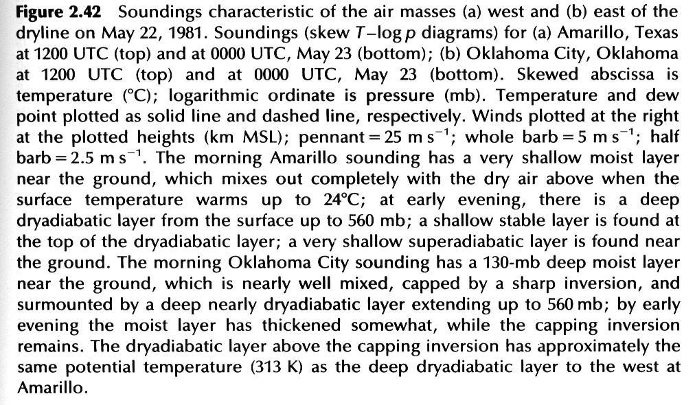
7 Amarillo TX and OKC soundings at 12 UTC (6am CST) May 22, 1981 and 00 UTC (6pm CST) May 23, 1981, corresponding to last example case Amarillo TX OKC 12 UTC, 22 May (6am LST) 00 UTC, 23 May (6 pm LST) 7
8 8
9 The May 11, 1970 Case 25F 57F Strong moisture gradient is found across the dryline Nocturnal inversion is found at the surface. An inversion is found to the east of the dryline at ~850mb level, capping moist air below No clear horizontal θ gradient separating the dry and moist air 03 CST, 11 May CST, 11 May 1970 Dryline was between Carlsbad, New Mexico (T d = 25 F) and Wink, Texas (T d = 57 F). 9
10 10
11 In the afternoon, a typical dryline structure is found To the west of dryline, ML extended to ~600mb Upward bulge of moisture at the dryline is an indicator of moist convection A lid still exits to the east above the surface moist layer Second cross-section is about 200 miles to the north it again shows a typical dryline structure 11
12 TYPICAL BACKGROUND CONDITIONS FOR DRY LINES 1. Surface anticyclone to the east, allowing moist Gulf air to flow into the Great Plains 2. Westerly flow aloft, causing a lee trough, and providing a confluence zone for the concentration of the moisture gradient 3. The presence of a stable layer or "capping inversion" or "lid" aloft. The southerly flow under this lid is often called "underrunning". 4. Because the terrain slopes upward to the west, the moist layer is shallow at the west edge of the moist air, and deeper to the east. This sets the stage for understanding the movement of the dry line. 12
13 MOVEMENT OF THE DRY LINE Under "quiescent" (i.e., in the absence of strong synoptic-scale forcing) conditions, the dryline usually moves eastward during the day and westward at night, as shown by the following example (we have just looked at the vertical structure of this case) 0300 CST 1500 CST 0300 CST, day 2 13
14 1. As the sun rises, the heating of the surface near the dry line is greater than that of the surface to the east in the deeper moist air (the difference in soil moisture content and low-level cloudiness often also contribute to such differential heating) 2. Thus it takes less insolation to mix out the shallow mixed layer just to the east of the initial dry line position (see Figure). This mixing out brings dry air (and westerly momentum) downward, and the position of the dry line moves eastward. 14
15 3. As the heating continues, deeper and deeper moist layers are mixed out, causing the apparent eastward "propagation" of the dry line. This propagation is not necessarily continuous or at a rate equal to the wind component normal to the dry line. 4. Eventually, the heating is insufficient to mix out the moist layer and propagation stops. 5. If a well-defined jet streak exists aloft, we often see a "dry line bulge" underneath the jet, as this air has the most westerly momentum to mix downward. The strong westerly momentum mixed down from above provides extra push for the eastward propagation of dryline 15

16 6. After sunset, the vertical mixing dies out, the westerly momentum at the surface west of the dryline weakens, the surface winds will back to a southeasterly direction in response to the lower pressure to the west. The moist air east of the dry line will be advected back toward the west, and surface stations will experience an east to west dry line passage. The above case assuming synoptic scale forcing is weak the situation is quiescent. If synoptic forcing is strong, the dryline may continue to be advected eastward in association with a surface low pressure system. 16
17 Sometimes, there exists a cold front behind the dryline that eventually catch up to the dry line. 17
18 The dryline as a focus of convection Possible reasons why convection initiates near dry lines: 1. Surface convergence between winds with easterly component east of the dry line and westerly component west of the dry line. 2. Dryline is the westernmost boundary of moist, convectively unstable air. The area along it and immediately east is the first region susceptible to convection encountered by the vertical motion associated with traveling disturbances from the west. 3. Gravity waves may form on or near the dry line, possibly triggering the first release of potential instability (Koch abd McCarthy 1982). 4. Dryline bulges provide an even greater focus for surface moisture convergence 5. "Underrunning" air moves northward until cap is weaker and/or large- or mesoscale forcing is strong enough to release the instability. Convective temperature may be reached just east of the dry line. Some observations: The reason for most tornado chase "busts" is that the advection of warm, dry air over the moist layer is building the cap or lid strength faster than the surface heating can overcome, thus convection never occurs. 18
2.4. Applications of Boundary Layer Meteorology
 2.4. Applications of Boundary Layer Meteorology 2.4.1. Temporal Evolution & Prediction of the PBL Earlier, we saw the following figure showing the diurnal evolution of PBL. With a typical diurnal cycle,
Mesoscale Meteorology
 Mesoscale Meteorology METR 4433 Spring 2015 3.4 Drylines The dryline is a mesoscale phenomena whose development and evaluation is strongly linked to the PBL. In this section, we will consider its general
Chapter 2. Turbulence and the Planetary Boundary Layer
 Chapter 2. Turbulence and the Planetary Boundary Layer In the chapter we will first have a qualitative overview of the PBL then learn the concept of Reynolds averaging and derive the Reynolds averaged
Local Winds. Please read Ahrens Chapter 10
 Local Winds Please read Ahrens Chapter 10 Scales of Motion Microscale: meters Turbulent eddies Formed by mechanical disturbance or convection Lifetimes of minutes Mesoscale: km s to 100 s of km s Local
WEATHER SYSTEMS OF MIDDLE LATITUDES
 CHAPTER 10 WEATHER SYSTEMS OF MIDDLE LATITUDES MULTIPLE CHOICE QUESTIONS 1. In equal volumes, which one of the following air masses exerts the highest surface air pressure? a. cp *b. A c. mp d. ct e. mt
Wind: Small Scale and Local Systems Chapter 9 Part 1
 Wind: Small Scale and Local Systems Chapter 9 Part 1 Atmospheric scales of motion Scales of atmospheric circulations range from meters or less to thousands of kilometers- millions of meters Time scales
Meteorology. Circle the letter that corresponds to the correct answer
 Chapter 4 Worksheet 3 Meteorology Name: Circle the letter that corresponds to the correct answer 1) Natural convection and turbulence are most likely to occur when: a) temperature decreases rapidly with
Sea and Land Breezes METR 4433, Mesoscale Meteorology Spring 2006 (some of the material in this section came from ZMAG)
") Sea and Land Breezes METR 4433, Mesoscale Meteorology Spring 2006 (some of the material in this section came from ZMAG) 1 Definitions: The sea breeze is a local, thermally direct circulation arising from
Sea and Land Breezes METR 4433, Mesoscale Meteorology Spring 2006 (some of the material in this section came from ZMAG) 1 Definitions: The sea breeze is a local, thermally direct circulation arising from
Vertical Motion and Atmospheric Stability
 Lesson 4 Vertical Motion and Atmospheric Stability This lesson describes the vertical structure of the atmosphere, atmospheric stability and the corresponding vertical motion. Adiabatic diagrams are introduced
METEOROLOGICAL GUIDE LA ROUTE DES TAMARINS PWC 2014 REUNION ISLAND
 METEOROLOGICAL GUIDE LA ROUTE DES TAMARINS PWC 2014 REUNION ISLAND From the 14 th to 18 th of November 2008 1. PREVAILING WINDS The Reunion island is situated on the 21 st parallel south. Its climate as
+ R. gr T. This equation is solved by the quadratic formula, the solution, as shown in the Holton text notes given as part of the class lecture notes:
 Homework #4 Key: Physical explanations 1.The way water drains down a sink, counterclockwise or clockwise, is independent of which hemisphere you are in. A draining sink is an example of vortex in cyclostrophic
ABSTRACT INTRODUCTION
 Numerical investigation of the formation of elevated pollution layers over the Los Angeles air basin Rong Lu, R.P. Turco Department of Atmospheric Sciences, University of California, Los Angeles, 405 Hilgard
The atmospheric circulation system
 The atmospheric circulation system Key questions Why does the air move? Are the movements of the winds random across the surface of the Earth, or do they follow regular patterns? What implications do these
ATMS 310 Tropical Dynamics
 ATMS 310 Tropical Dynamics Introduction Throughout the semester we have focused on mid-latitude dynamics. This is not to say that the dynamics of other parts of the world, such as the tropics, are any
Cold Air Damming. Introduction. Learning Objectives. Cold Air Damming. Cold Air Damming. Cold Air Damming 9/28/17. After this class you should
 Learning Objectives Atmos6250: Mountain Meteorology Jim Steenburgh Department of Atmospheric Sciences University of Utah Jim.Steenburgh@utah.edu After this class you should Recognize areas of North America
BUF PIT SLO HTS AHN 10.0 CHS CKL AYS
 Cold-air damming When a cold anticyclone is located to the north of an approximately north-south oriented mountain range in winter, a pool of cold air may become entrenched along the eastern slope and
ATS 351 Lecture 6. Air Parcel. Air Parcel Movement: Why does rising air expand and cool? Stability & Skew-T Diagrams
 ATS 351 Lecture 6 Stability & Skew-T Diagrams To demonstrate stability, a parcel of air is used Expands and contracts freely Always has uniform properties throughout Air Parcel Air Parcel Movement: Why
MET Lecture 8 Atmospheric Stability
 MET 4300 Lecture 8 Atmospheric Stability Stability Concept Stable: Ball returns to original position Neutral: Ball stays wherever it is placed Unstable: Displacement grows with time. Atmospheric Stability
Monsoon. Arabic word mausim means season. Loose definition: a wind/precipitation pattern that shifts seasonally
 Monsoon Arabic word mausim means season Loose definition: a wind/precipitation pattern that shifts seasonally Classical criteria (Ramage 1971) Prevailing wind shifts 120 o between Jan & July Average frequency
Lecture 14. Heat lows and the TCZ
 Lecture 14 Heat lows and the TCZ ITCZ/TCZ and heat lows While the ITCZ/TCZ is associated with a trough at low levels, it must be noted that a low pressure at the surface and cyclonic vorticity at 850 hpa
9/25/2014. Scales of Atmospheric Motion. Scales of Atmospheric Motion. Chapter 7: Circulation of the Atmosphere
 Chapter 7: Circulation of the Atmosphere The Atmosphere: An Introduction to Meteorology, 12 th Lutgens Tarbuck Lectures by: Heather Gallacher, Cleveland State University Scales of Atmospheric Motion Small-
AT350 EXAM #2 November 18, 2003
 AT350 EXAM #2 November 18, 2003 Name and ID: Enter your name and student ID number on the answer sheet and on this exam. Record your answers to the 50 questions by using a No. 2 pencil to completely fill
ATMOSPHERIC CIRCULATION. WIND = The horizontal movement of air. Results from the differences in air pressure. Always moves from HIGH to LOW.
 ATMOSPHERIC CIRCULATION WIND = The horizontal movement of air. Results from the differences in air pressure. Always moves from HIGH to LOW. Pressure differences result from variations in temperature. AIR
Chapter 6: Atmospheric Pressure, Wind, and Global Circulation
 Discovering Physical Geography Third Edition by Alan Arbogast Chapter 6: Atmospheric Pressure, Wind, and Global Circulation Factors That Influence Air Pressure Air Pressure is the measured weight of air
PHSC 3033: Meteorology Stability
 PHSC 3033: Meteorology Stability Equilibrium and Stability Equilibrium s 2 States: Stable Unstable Perturbed from its initial state, an object can either tend to return to equilibrium (A. stable) or deviate
VI. Static Stability. Consider a parcel of unsaturated air. Assume the actual lapse rate is less than the dry adiabatic lapse rate: Γ < Γ d
 VI. Static Stability Consider a parcel of unsaturated air. Assume the actual lapse rate is less than the dry adiabatic lapse rate: Γ < Γ d VI. Static Stability Consider a parcel of unsaturated air. Assume
Characterization of Boundary-Layer Meteorology During DISCOVER-AQ
 Characterization of Boundary-Layer Meteorology During DISCOVER-AQ Daniel M. Alrick and Clinton P. MacDonald Sonoma Technology, Inc. Gary A. Morris St. Edward s University for Texas Air Quality Research
REMINDERS: Problem Set 2: Due Monday (Feb 3)
") REMINDERS: Problem Set 2: Due Monday (Feb 3) Midterm 1: Next Wednesday, Feb 5 - Lecture material covering chapters 1-5 - Multiple Choice, Short Answers, Definitions - Practice midterm will be on course
REMINDERS: Problem Set 2: Due Monday (Feb 3) Midterm 1: Next Wednesday, Feb 5 - Lecture material covering chapters 1-5 - Multiple Choice, Short Answers, Definitions - Practice midterm will be on course
Synoptic features of orographically enhanced heavy rainfall on the east coast of Korea associated with Typhoon Rusa (2002)
") Click Here for Full Article GEOPHYSICAL RESEARCH LETTERS, VOL. 34, L02803, doi:10.1029/2006gl028592, 2007 Synoptic features of orographically enhanced heavy rainfall on the east coast of Korea associated
Click Here for Full Article GEOPHYSICAL RESEARCH LETTERS, VOL. 34, L02803, doi:10.1029/2006gl028592, 2007 Synoptic features of orographically enhanced heavy rainfall on the east coast of Korea associated
SESSION THREE: FACTORS THAT INFLUENCE WEATHER IN SOUTH AFRICA
 SESSION THREE: FACTORS THAT INFLUENCE WEATHER IN SOUTH AFRICA KEY CONCEPTS: In this section we will focus on the following aspects: Factors determining the weather of South Africa Influence of the oceans
Chapter 8. Circulation of The Atmosphere
 Chapter 8 Circulation of The Atmosphere Scales of Atmospheric Motion Atmospheric circulations are broken-down into different scales bases on physical size and duration. Macroscale This is the largest scale,
Air Pollution Dispersion
 Air Pollution Dispersion Dispersion Processes Convective Dispersion Air Parcel Dynamics Adiabatic Process Lapse Rate Equilibrium and Stability Atmospheric Stability Stability and Dispersion Temperature
Wind: Small-scale and Local Systems
 Wind: Small-scale and Local Systems Scales of Atmospheric Motion Atmospheric motions/phenomena occur on many diverse spatial and temporal scales. Weather forecasters tend to focus on Mesoscale and synoptic
Chapter 8 Air Masses
 Chapter 8 Air Masses Air Masses - 1 1. An Air Mass is a large body of air usually about 1500 km across and several km thick, that has homogeneous physical properties. 2. The important physical properties
Scott Denning CSU CMMAP 1
 Thermodynamics, Buoyancy, and Vertical Motion Temperature, Pressure, and Density Buoyancy and Static Stability Adiabatic Lapse Rates Dry and Moist Convective Motions Present Atmospheric Composition What
MET 200 Lecture 11 Local Winds. Last Lecture: Forces. Review of Forces. Balance of Forces
 MET 200 Lecture 11 Local Winds Last Lecture: Forces Scales of Motion Eddies Sea Breeze Mountain-Valley Circulations Chinook - Snow Eater Drainage Wind - Katabatic Wind 1 2 Review of Forces 1. Pressure
Abrupt marine boundary layer changes revealed by airborne in situ and lidar measurements
 Abrupt marine boundary layer changes revealed by airborne in situ and lidar measurements David A. Rahn 1, Thomas R. Parish 2, and David Leon 2 1 Univeristy of Kansas 2 Univeristy of Wyoming Precision Atmospheric
Lecture 7. The Indian monsoon: is it a gigantic land-sea breeze?
 Lecture 7 The Indian monsoon: is it a gigantic land-sea breeze? In the next set of lectures I am going to discuss the different hypotheses put forth for the basic system responsible for the monsoon. I
Winds and Ocean Circulations
 Winds and Ocean Circulations AT 351 Lab 5 February 20, 2008 Sea Surface Temperatures 1 Temperature Structure of the Ocean Ocean Currents 2 What causes ocean circulation? The direction of most ocean currents
Atmospheric Stability. GEOG/ENST 2331 Lecture 10 Ahrens: Chapter 6
 Atmospheric Stability GEOG/ENST 2331 Lecture 10 Ahrens: Chapter 6 Last lecture: Thanks to Dr. Stewart! Hydrologic cycle! Humidity! Diabatic: convection, conduction, radiation; mixing! Adiabatic: change
Darwin s mid-evening surge
 Australian Meteorological and Oceanographic Journal 60 (2010) 25-36 Darwin s mid-evening surge Gerald L. Thomsen and Roger K. Smith Meteorological Institute, University of Munich, Germany (Manuscript received
Gravity waves and bores. Material kindly provided by Dr. Steven Koch GSD NOAA (Boulder, CO)
") Gravity waves and bores Material kindly provided by Dr. Steven Koch GSD NOAA (Boulder, CO) Presented at Iowa State University 11 April 2005 What is a gravity wave? An oscillation caused by the displacement
Gravity waves and bores Material kindly provided by Dr. Steven Koch GSD NOAA (Boulder, CO) Presented at Iowa State University 11 April 2005 What is a gravity wave? An oscillation caused by the displacement
Lecture 13 March 24, 2010, Wednesday. Atmospheric Pressure & Wind: Part 4
 Lecture 13 March 24, 2010, Wednesday Atmospheric Pressure & Wind: Part 4 Synoptic scale winds Mesoscale winds Microscale winds Air-sea interactions The largest synoptic scale wind. Monsoon: Arabic for
Meteorology. Circle the letter that corresponds to the correct answer
 Chapter 7 Worksheet 2 Meteorology Name: Circle the letter that corresponds to the correct answer 1) Which of the following factors contributes to the general subsidence in the latitude zone 20 degrees
Global Circulations. GEOG/ENST 2331 Lecture 15 Ahrens: Chapter 10
 Global Circulations GEOG/ENST 2331 Lecture 15 Ahrens: Chapter 10 Last lecture Microscale (turbulence) Mesoscale (land/sea breeze) Synoptic scale (monsoon) Global scale (3 cell circulation) Three Cell Model
Darwin s mid-evening surge
 Darwin s mid-evening surge Gerald L. Thomsen and Roger K. Smith Meteorological Institute, University of Munich, Germany November 11, 2009 Corresponding author: Gerald Thomsen, gerald@meteo.physik.uni-muenchen.de
McKnight's Physical Geography 11e
 Chapter 2 Lecture McKnight's Physical Geography 11e Lectures Chapter 5 Atmospheric Pressure and Wind Michael Commons Ohio Northern University Atmospheric Pressure and Wind The Nature of Atmospheric Pressure
Ocean Currents that Redistribute Heat Globally
 Ocean Currents that Redistribute Heat Globally Ocean Circulation Ocean Currents Fig. CO7 OCEAN CURRENTS Surface ocean currents are similar to wind patterns: 1. Driven by Coriolis forces 2. Driven by winds
National Weather Service
 National Weather Service Gulf of California Moisture Surges Gulf of California moisture surges, or simply Gulf Surges, are one of the most researched components of the North American Monsoon. As early
TOPICS YOU NEED TO KNOW
 ATMO 101 Introduction to Meteorology Midterm Study Sheet Chapters 6, 7, 8 and 10 Exam Thursday 3/23/2017 Vocabulary Words for True and False, and Multiple Choice You are responsible for the following words:
ENVIRONMENTAL PHYSICS
 ENVIRONMENTAL PHYSICS Atmospheric Stability An understanding of why and how air moves in the atmosphere is fundamental to the prediction of weather and climate. What happens to air as it moves up and down
Chapter 22, Section 1 - Ocean Currents. Section Objectives
 Chapter 22, Section 1 - Ocean Currents Section Objectives Intro Surface Currents Factors Affecting Ocean Currents Global Wind Belts (you should draw and label a diagram of the global wind belts) The Coriolis
Boundary layer meso-scale flows. Hannu Savijärvi University of Helsinki
 Boundary layer meso-scale flows Hannu Savijärvi University of Helsinki Contents Mechanical channeling Thermal heat islands Slope winds Sea breezes Thermal channeling on a sea gulf spring, early summer
The total precipitation (P) is determined by the average rainfall rate (R) and the duration (D),
 is determined by the average rainfall rate (R) and the duration (D),") Orographic precipitation Common ingredients of heavy orographic precipitation The total precipitation (P) is determined by the average rainfall rate (R) and the duration (D), P = RD. (1) The rainfall rate
Orographic precipitation Common ingredients of heavy orographic precipitation The total precipitation (P) is determined by the average rainfall rate (R) and the duration (D), P = RD. (1) The rainfall rate
Mountain Forced Flows
 Mountain Forced Flows Jeremy A. Gibbs University of Oklahoma gibbz@ou.edu February 3, 2015 1 / 45 Overview Orographic Precipitation Common Ingredients of Heavy Orographic Precipitation Formation and Enhancement
Scales of Atmospheric Motion
 Lecture 12 Local Wind Systems Scales of Atmospheric Motion Small turbulent eddies (swirls) A synoptic eddy 1 Coriolis Effect The larger the scale, the longer the life time. Wind shear and turbulent eddy
Measuring characteristics of fronts
 Atmospheric Measurements and Observations EAS 535 Measuring characteristics of fronts Dr. J. Haase http://web.ics.purdue.edu/~jhaase/teaching/eas535/index.html Vertical structure Contours of potential
Chapter 10: Global Wind Systems
 Chapter 10: Global Wind Systems Three-cell model of atmospheric circulation Intertropical Convergence Zone (ITCZ) Typical surface wind patterns Upper-level pressure and winds Climatological sea-level pressure
Adiabatic Lapse Rates and Atmospheric Stability
 8 Adiabatic Lapse Rates and Atmospheric Stability Learning Goals After studying this chapter, students should be able to: 1. describe adiabatic processes as they apply to the atmosphere (p. 174); 2. apply
Prof. Geraint Vaughan. Centre for Atmospheric Science School of Earth, Atmospheric and Environmental Sciences. Bogdan Antonescu
 Upper-level fronts tropopause disturbances and convection Prof. Geraint Vaughan Centre for Atmospheric Science School of Earth, Atmospheric and Environmental Sciences Bogdan Antonescu the meteorological
Atmospheric Stability/Skew-T Diagrams. Fall 2016
 Atmospheric Stability/Skew-T Diagrams Fall 2016 Air Parcel Consider a parcel of infinitesimal dimensions that is: Thermally isolated from the environment so that its temperature changes adiabatically as
CHAPTER 9. More on meteorology
 CHAPTER 9 More on meteorology 1). Atmospheric Pressure Atmospheric pressure is the pressure with which the atmosphere acts downwards due to its weight. Pressure decreases with altitude because the column
Envs, Geol, Phys 112: Global Climate. Energy-Atmosphere System Review Aguado & Bert, Ch. 1, 2, 3, 4, 5, 6, 9, 10
 Exam 1 Review Energy-Atmosphere System Review Aguado & Bert, Ch. 1, 2, 3, 4, 5, 6, 9, 10 Location on Earth (L04) Latitude & Longitude great circles, prime meridian, time zones, cardinal points, azimuth
Organized Deep Cumulus Convection Over the South China Sea and its Interaction with Cold Surges
 December 1983 F.-C. Zhu 839 Organized Deep Cumulus Convection Over the South China Sea and its Interaction with Cold Surges By Fu-Cheng Zhu* Atmospheric Physics Group, Imperial College, London, U.K. (Manuscript
2.2 Southwest Monsoon
 2.2 Southwest Monsoon While many manuals place their discussion of the northeast monsoon first-since it can be associated with January, the first month of the year-the southwest monsoon is presented first
Civil Air Patrol Auxiliary of the United States Air Force
 Mountain Flying Qualification Course Civil Air Patrol Auxiliary of the United States Air Force Mountain Weather Slopes Most U.S. mountain ranges are oriented north-south, while the prevailing winds are
Chapter 4. Convec.on Adiaba.c lapse rate
 Chapter 4 Convec.on Adiaba.c lapse rate 1.Outline: a. air parcel theory, adiabatic processes b. how do we define/determine atmospheric stability? 2.Readings: Chapter 4 VERTICAL STRUCTURE T STRATIFICATION
Chapter 7: Circulation And The Atmosphere
 Chapter 7: Circulation And The Atmosphere Highly integrated wind system Main Circulation Currents: series of deep rivers of air encircling the planet Various perturbations or vortices (hurricanes, tornados,
APPI PPG LECTURE 5: FURTHER METEOROLOGY
 LECTURE 5: FURTHER METEOROLOGY Introduction: This lecture covers Further Meteorology and aims to give you more of an understanding of advanced weather conditions and patterns. However Meteorology is a
EVE 402/502 Air Pollution Generation and Control. Introduction. Intro, cont d 9/18/2015. Chapter #3 Meteorology
 EVE 402/502 Air Pollution Generation and Control Chapter #3 Meteorology Introduction Meteorology is the study and forecasting of weather changes resulting from large-scale atmospheric circulation Characteristics
SIO20 - Midterm Examination 2 v1 Winter Section A. Circle the letter corresponding to the best answer. (1 point each)
") NAME: Section A. Circle the letter corresponding to the best answer. (1 point each) 1. Rainbows result from: a. refraction and reflection of sunlight by water droplets b. reflection of sunlight by oceans
NAME: Section A. Circle the letter corresponding to the best answer. (1 point each) 1. Rainbows result from: a. refraction and reflection of sunlight by water droplets b. reflection of sunlight by oceans
10.6 The Dynamics of Drainage Flows Developed on a Low Angle Slope in a Large Valley Sharon Zhong 1 and C. David Whiteman 2
 10.6 The Dynamics of Drainage Flows Developed on a Low Angle Slope in a Large Valley Sharon Zhong 1 and C. David Whiteman 2 1Department of Geosciences, University of Houston, Houston, TX 2Pacific Northwest
What is Air Temperature? Temperature, Buoyancy, and Vertical Motion. How Atmospehric Temperature is Measured. Temperature Scales
 Temperature, Buoyancy, and Vertical Motion Temperature, Pressure, and Density Buoyancy and Static Stability Temperature Lapse Rates Rising & Falling Motions in the Air What is Air Temperature? Temperature
Impact of Sea Breeze Fronts on Urban Heat Island & Air Quality in Texas
 Impact of Sea Breeze Fronts on Urban Heat Island & Air Quality in Texas Xiao-Ming Hu Center for Analysis and Prediction of Storms, School of Meteorology University of Oklahoma July 14, 2015 at LanZhou
Air Masses and Fronts. Holt Science and Technology Weather and Climate Chapter 2, Section 2
 Air Masses and Fronts Holt Science and Technology Weather and Climate Chapter 2, Section 2 Types of Air Masses Changes in weather are caused by the movement and interaction of air masses. An air mass is
It seemed that airplanes arriving and departing AVWEATHER
 BY ED BROTAK It seemed that airplanes arriving and departing from Will Rogers World Airport in Oklahoma City, Oklahoma, United States, on the morning of Aug. 3, 2012, would have few problems with wind
METEOROLOGICAL FACTORS AFFECTING ENVIRONMENTAL NOISE PROPAGATION OVER SEVERAL KILOMETRES
 METEOROLOGICAL FACTORS AFFECTING ENVIRONMENTAL NOISE PROPAGATION OVER SEVERAL KILOMETRES Abstract Aleks Todoroski Todoroski Air Sciences 2b, 14 Glen Street Eastwood NSW 2122, Australia Email: atodoroski@airsciences.com.au
>>>>>>>>WHEN YOU FINISH <<<<<<<< Hand in the answer sheet separately.
 Instructor: Prof. Seiberling PHYSICS DEPARTMENT MET 1010 2nd Midterm Exam October 28, 2002 Name (print, last rst): Signature: On my honor, I have neither given nor received unauthorized aid on this examination.
Atmospheric Rossby Waves Fall 2012: Analysis of Northern and Southern 500hPa Height Fields and Zonal Wind Speed
 Atmospheric Rossby Waves Fall 12: Analysis of Northern and Southern hpa Height Fields and Zonal Wind Speed Samuel Schreier, Sarah Stewart, Ashley Christensen, and Tristan Morath Department of Atmospheric
Lecture 20. Active-weak spells and breaks in the monsoon: Part 1
 Lecture 20 Active-weak spells and breaks in the monsoon: Part 1 Although the summer monsoon season is the rainy season over most of the Indian region, it does not rain every day, at any place, during the
Goals for today: continuing Ch 8: Atmospheric Circulation and Pressure Distributions. 26 Oct., 2011
 Goals for today: 26 Oct., 2011 continuing Ch 8: Atmospheric Circulation and Pressure Distributions Examples of synoptic scale and mesoscale circulation systems that are driven by geographic diversity in
ASSESSMENT OF SEA BREEZE CHARACTERISTICS FROM SODAR ECHOGRAMS
 ASSESSMENT OF SEA BREEZE CHARACTERISTICS FROM SODAR ECHOGRAMS SUNEETHA RANI. JUPUDI Prof. M. PURNACHANDRA RAO Department of Physics, Andhra University, Visakhapatnam, India. ABSTRACT The SODAR echograms
Idealized WRF model sensitivity simulations of sea breeze types and their effects on offshore windfields: Supplementary material
 Idealized WRF model sensitivity simulations of sea breeze types and their effects on offshore windfields: Supplementary material Authors: C. J. Steele, S. R. Dorling, R. von Glasow and J. Bacon Synoptic
CHAPTER 8 WIND AND WEATHER MULTIPLE CHOICE QUESTIONS
 CHAPTER 8 WIND AND WEATHER MULTIPLE CHOICE QUESTIONS 1. is the movement of air measured relative to the Earth's surface. a. Gravity b. The pressure gradient force c. The Coriolis Effect d. The centripetal
Isaac Newton ( )
") Introduction to Climatology GEOGRAPHY 300 Isaac Newton (1642-1727) Tom Giambelluca University of Hawai i at Mānoa Atmospheric Pressure, Wind, and The General Circulation Philosophiæ Naturalis Principia
Introduction to Climatology GEOGRAPHY 300 Isaac Newton (1642-1727) Tom Giambelluca University of Hawai i at Mānoa Atmospheric Pressure, Wind, and The General Circulation Philosophiæ Naturalis Principia
Lecture 18: El Niño. Atmosphere, Ocean, Climate Dynamics EESS 146B/246B
 Lecture 18: El Niño Atmosphere, Ocean, Climate Dynamics EESS 146B/246B El Niño Transient equatorial motions: Kelvin and Rossby waves. Positive feedback mechanism associated with air-sea coupling. Atmospheric
The Dynamics of Northwest Summer Winds over the Santa Barbara Channel
 1042 MONTHLY WEATHER REVIEW VOLUME 129 The Dynamics of Northwest Summer Winds over the Santa Barbara Channel ERIC D. SKYLLINGSTAD AND PHILIP BARBOUR College of Oceanic and Atmospheric Sciences, Oregon
Cloud Development and Forms
 Chapter 6 Lecture Understanding Weather and Climate Seventh Edition Cloud Development and Forms Redina L. Herman Western Illinois University Mechanisms That Lift Air When air lifts, clouds develop and
Figure 1. Modeling domains used in WRF-ARW
 SIMULATION OF TRANSPORT AND DISPERSION OF POLLUTANTS FROM ELEVATED POINT SOURCES IN MISSISSIPPI GULF COAST USING A MESOSCALE ATMOSPHERIC DISPERSION MODELING SYSTEM Venkata Srinivas Challa, Jayakumar Indracanti,
Section 1. Global Wind Patterns and Weather. What Do You See? Think About It. Investigate. Learning Outcomes
 Chapter 5 Winds, Oceans, Weather, and Climate Section 1 Global Wind Patterns and Weather What Do You See? Learning Outcomes In this section, you will Determine the effects of Earth s rotation and the uneven
The Coriolis force, geostrophy, Rossby waves and the westward intensification
 Chapter 3 The Coriolis force, geostrophy, Rossby waves and the westward intensification The oceanic circulation is the result of a certain balance of forces. Geophysical Fluid Dynamics shows that a very
QUARTERLY JOURNAL ROYAL METEOROLOGICAL SOCIETY
 QUARTERLY JOURNAL OF THE ROYAL METEOROLOGICAL SOCIETY Vol. 132 APRIL 2006 Part A No. 616 Q. J. R. Meteorol. Soc. (2006), 132, pp. 691 707 doi: 10.1256/qj.05.126 Simulations of low-level convergence lines
ESCI 107 The Atmosphere Lesson 11 Global Circulation
 Reading: Meteorology Today, Chapter 10 THE GLOBAL CIRCULATION ESCI 107 The Atmosphere Lesson 11 Global Circulation Latitudinal heat imbalance The tropics receive more radiation than they emit. The polar
Directed Reading. Section: Ocean Currents. a(n). FACTORS THAT AFFECT SURFACE CURRENTS
. FACTORS THAT AFFECT SURFACE CURRENTS") Skills Worksheet Directed Reading Section: Ocean Currents 1. A horizontal movement of water in a well-defined pattern is called a(n). 2. What are two ways that oceanographers identify ocean currents? 3.
Skills Worksheet Directed Reading Section: Ocean Currents 1. A horizontal movement of water in a well-defined pattern is called a(n). 2. What are two ways that oceanographers identify ocean currents? 3.
Summary of Lecture 10, 04 March 2008 Introduce the Hadley circulation and examine global weather patterns. Discuss jet stream dynamics jet streams
 Summary of Lecture 10, 04 March 2008 Introduce the Hadley circulation and examine global weather patterns. Discuss jet stream dynamics jet streams arise because the Coriolis force prevents Hadley-type
Title: Gravity wave over flat terrain.
 Title: Gravity wave over flat terrain. Author: Daniel L. Johnson (MD), Mayo Clinic Health System, drdan@wwt.net Abstract: Wave is everywhere throughout the atmosphere, whereever shear exists. Standing
Gravity waves in stable atmospheric boundary layers
 Gravity waves in stable atmospheric boundary layers Carmen J. Nappo CJN Research Meteorology Knoxville, Tennessee 37919, USA Abstract Gravity waves permeate the stable atmospheric planetary boundary layer,
Horizontal movement of air between cooler and warmer regions. - horizontal movement of air Convection over areas where is
 Winds and Water Chapter 9 continued... Uneven Heating The various materials of the earth absorb and emit energy at different rates Convection Heated air expands; density reduced; air rises Upward movement
Santa Ana Winds. Surface weather map showing typical Santa Ana conditions.
 Santa Ana Winds Surface weather map showing typical Santa Ana conditions. High Desert Elevation ~1500-2000 ft Santa Ana Winds ~1500 meters 0 meters Santa Ana Winds ~875 mb ~1500 meters ~875 mb Horizontal
Assessment Schedule 2016 Earth and Space Science: Demonstrate understanding of processes in the ocean system (91413)
") NCEA Level 3 Earth & Space Science (91413) 2016 page 1 of 6 Assessment Schedule 2016 Earth and Space Science: Demonstrate processes in the ocean system (91413) Evidence Statement Q Evidence with with Excellence
NCEA Level 3 Earth & Space Science (91413) 2016 page 1 of 6 Assessment Schedule 2016 Earth and Space Science: Demonstrate processes in the ocean system (91413) Evidence Statement Q Evidence with with Excellence