Application for. Foreshore Lease. for the. Construction. and. Operation of an
|
|
|
- Gary Evans
- 5 years ago
- Views:
Transcription
1 Application for a Foreshore Lease for the Construction and Operation of an Offshore Electricity Generating Station cat2lce Complete and return, with fourteen (14) copies of EIS and Admiralty Charts and one copy of the Articles of Association, to Foreshore Section, Department of the Marine and Natural Resources, Leeson Lane, Dublin 2 44
2 APPLICATION FOR FORESHORE LEASE TO CONSTRUCT AN OFFSHORE ELECTRICITY GENERATING STATION (Please read the guidance notes before completing this application form) 1. Applicant s Name: Bray Offshore Wind Ltd Address: Kerry Technology Park, Listowel Road, Tralee, Co. Kerry Fax aidan.forde@saorgus.com 1. (a) Name and address of applicant s legal advisor Mark Varian, O'Donnell Sweeney, One Earlsfort Centre, Earlsfort Terrace, Dublin Fax mvarian@odonnellsweeney.ie 2. Nature of proposed generating station (i.e. wind powered, wave powered, etc.) Wind powered 3. Details of Authorisation to construct and Licence to generate and supply issued by the Commission for Electricity Regulation (include. photocopies) Applications for an Authorisation to Construct and a Generation Licence have been made to CER and are being processed. See attached letter of confirmation from CER. 4. Longitude and Latitude of proposed generating station site boundaries See attached response. 4.(a) Where the area can be identified on the Ordnance Survey map, the Ordnance survey co-ordinates should also be shown Area cannot be identified on OS map 5. Longitude and Latitude of the central Point of the proposed wind farm 53 deg 11 min 30 sec N; 5 deg 54 min 30 sec W 5(a) Where the area can be identified on the Ordnance Survey map, the Ordnance survey co-ordinates should also be shown Area cannot be identified on OS map 45
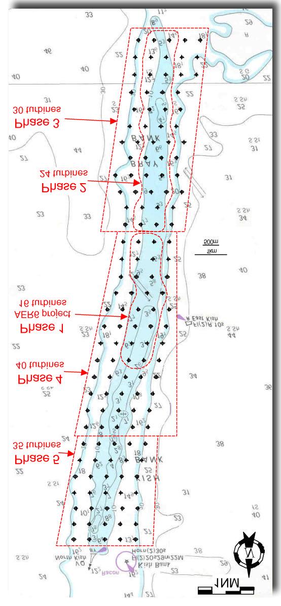
3 6. Area to be covered by the proposed generating station 2,000 Ha 7. Dimension of the generating station area at its longest and widest points Length: 8.0 km Width: 2.5 km 8. Number & location of turbines within the area (indicate on charts) 70 turbines. See attached site layout diagram. 9. Maximum height of turbines above chart datum (including, in the case of windfarms, blades when vertical) 160 m 10. Rotor diameter of turbines (in the case of windfarms) up to 120 m 11. Physical dimensions of each complete structure including anchorage or foundation * Turbine tower: See attached diagrams in response to Q12 & Q13. Foundation: Diameter up to 35 m. See attached diagrams in response to Q12 & Q Nature of construction below sea- level* See attached diagram and response. 13. Nature of construction above sea-level* See attached diagram and response. 14. Manner in which structures will be anchored to the sea bed (i.e. cable, set in concrete foundations, etc.)* See attached diagram and response. * Provide scaled drawings with the responses to these questions. 15. Nearest distance from other generating stations or other constructions on the sea-bed (including constructions anchored permanently or semi-permanently to the sea-bed) ** See attached diagram and response. 16. Distance from shore at nearest point 10.2 km (see attached diagram) ** 17. Distance from nearest habitation 10.2 km (see attached diagram) ** 18. Distance from nearest Aquaculture operation if less than 3 km None known to occur. 19. Distance from nearest Special Protection Area (SPA) or Special Area of Conservation (SAC) if less than 5 Km. N/A. See attached response. ** 46
4 20. Distance from shipping lanes at nearest point See attached diagram and response. ** ** Illustrate on the appropriate marine charts accompanying the application 21. Indicate any other economic or leisure activities known to take place within or adjacent to the area proposed for the generating station See attached response. CONDITIONS WHEN OPERATING 22. Maximum noise levels expected at the site See attached response. 23. Normal noise levels expected at the site See attached response. 24. Normal noise levels expected at site of nearest habitation See attached response. 25. Maximum Noise levels expected at site of nearest habitation See attached response. 26. Maximum noise levels expected at nearest SPA or SAC (if closer than 5 Km.) N/A - There are no SPAs or SACs located closer than 5 km. 27. Indicate conditions which might be expected (a) to increase noise levels above normal and (b) to maximum levels (a) Fault in major turbine component such as gearbox / blade. See response to (b). This combined with onshore winds would maximise noise levels. 28. Describe visual impact of the proposal at site of nearest habitation or human activity on-shore (indicate type of site (i.e. houses, beach, boat club, etc.) See attached response. 29. Designed maximum annual output of the proposed generating station Phase 1: 25 MW (74 GWh/yr). Phases 2-5: up to 372 MW (1,101 GWh/yr) 30.. Anticipated maximum annual output of the proposed generating station Phase 1: 25 MW (74 GWh/yr). Phases 2-5: 310 MW (918 GWh/yr) 31(a). Is an exclusion zone for passage of shipping (including fishing and leisure boats) sought (YES/NO) (If yes please supply details and give reasons) See attached response. (b) Is an exclusion zone (or ban) sought on the use of any type of fishing gear or leisure activity within the area occupied by the turbines and/or associated cables? See attached response. 47
5 See attached map indicating the area in question. (exclusion zone should be indicated on the appropriate marine charts which should accompany the application) 32. Capital Cost of Proposed Venture Phase 1: 50m; Phases 2-5: 370m - 745m. 33. Source of capital Debt finance (various banks interested) / equity (Corporate Finance Ireland) 34. Has consultation taken place with Dúchas - the National Heritage Service? (Yes/No) Yes. See attached correspondence. (If yes please supply copies of relevant correspondence ) 35. Have nearby harbour authorities been consulted (Yes/No) Yes. See attached correspondence. (If yes please supply copies of relevant correspondence ) Also consulted by Capt Tom Proctor on our behalf. 36. Has planning permission been received for shore based works? (if yes copy should be attached) No. See attached comments. If planning permission has not been received a copy of the planning application(s) should accompany the application) 37. Have necessary on-shore eaves been obtained? No. See attached comments. Signed for and on behalf of the applicant Name of Signatory (block letters) Aidan Forde Position Director Date 21 Dec 2005 Name address, telephone etc. details of contact (if different from that of the applicant) As per applicant details 48
6 Attachment to Accompany an Application for a Foreshore Lease for the Construction and Operation of an Offshore Electricity Generating Station on the Bray Bank - Bray Offshore Wind Ltd - 21 December 2005
7 Response to Q.3 See below letter of confirmation of applications for Authorisation to Construct and Generation Licence from CER.

8 Response to Q.4 The longitude and latitude of the proposed generating station site boundaries for the Bray Bank are as follows: A N 5-56 W B N 5-53 W C N 5-53 W D N 5-56 W This area is illustrated below:

9 Response to Q.8 The diagram below shows the location of turbines to be sited on both the Kish and Bray Banks. The southernmost 16 rows constitute the proposed generating station to be located on the Bray Bank.


 Dimensions: The piles have a diameter of between 1.5 m")
10 Response to Q.12 The nature of construction below sea-level would consist of one of the following foundation types: (A) Monopile (B) Multi-pile (tripod) (C) Gravity Caisson Monopile Dimensions: The diameter of the monopile varies from 3.5 m to 5.5 m, and it is driven a distance of between 20 m and 40 m into the seabed. Multipile (Tripod) Dimensions: The piles have a diameter of between 1.5 m and 3.5 m. The total area occupied by the structure is up to 35 m in diameter. Gravity Caisson Dimensions: Typically 15 m diameter, though can be as large as 25 m diameter depending on depth of water.
11 Response to Q.13 A diagram of the turbine tower as it would appear above sea-level is indicated below. The maximum hub height is 100 m and the maximum rotor diameter is 120 m.
: Monopile foundation turbine is driven / vibrated into the seabed Gravity caisson foundation turbine")
12 Response to Q.14 Turbine towers would be anchored to the seabed using one of the following methods (see diagram): Monopile foundation turbine is driven / vibrated into the seabed Gravity caisson foundation turbine is set in a concrete / steel caisson Multipile (tripod) foundation a variation of the piled foundation where more than one pile is used The type of foundation to be used at a particular location would depend on the ground conditions at that location.
.")
13 Response to Q.15 The proposed Bray Bank development would be located to the south of the Kish Lighthouse. The shortest distance between the Kish Lighthouse and turbines on the north of the Bray Bank would be 8.4 km (see diagram below). The proposed Codling Bank wind farm development would be located to the southeast of the Bray Bank development. The shortest distance between turbines on the south of the Bray Bank and those on the Codling Bank would be 3.1 km. The shortest distance between turbines from Phase 1 of the Bray Bank and those on the Codling Bank would be 9.1 km. Response to Q The distance from the proposed development to the nearest point onshore (and the nearest habitation) is 10.2 km (see diagram above). Response to Q.19 There are no SPAs or SACs located within 5 km of the proposed development. Bray Head (SAC, pnha) is located 10.4 km from the closest turbine of the development.
14 Response to Q.20 The distance from shipping lanes to the proposed development at the closest point is as follows: North Bray: The closest shipping lane to the north of the Bray bank passes 1-2 cables to the north of the Kish Lighthouse. This is located approximately 9 km to the north of the proposed development on the Bray Bank. Approximately 15% of Dublin traffic (6 passages per day) uses this shipping lane. See diagram below. South Bray: Traffic destined for Dublin (approx. 10 passages per day) passes within 1 nautical mile of the southern extremity of the Bray Bank. See diagram below. East Kish: Traffic destined for Dublin (approx. 3 passages per day) has a closest point of approach of approximately 4.5 nautical miles when passing the southern extremity of the Bray Bank to an average of 1.5 nautical miles when passing the northern extremity of the bank (marked by the Red Can Buoy). See diagram below. West Kish: Traffic operating to the west of the Bray Bank (approx. 3 passages per day) has a closest point of approach of approximately 1 nautical mile to the west of the Bray Bank. See diagram below. The shipping lanes in the vicinity of the Bray Bank are illustrated in the diagrams below. These diagrams were produced as part of the Sector Analysis for the Shipping Collision Risk Assessment study that was performed as part of the Environmental Impact Assessment.

15 9.0 Sector Analysis 9.1 North Kish The area under consideration is the Ferry/RoRo corridor North of Kish L/H. 1. The Holyhead-Dun Laoghaire Service: 6 passages per day 2. The Liverpool/Birkenhead- Dublin Service: 10 passages per day 3. The Heysham Dublin Service: 4 passages per day 4. The Holyhead-Dublin Service: 14 passages per day. 5. Scheduled and Unscheduled Traffic: 5 passages per day (1.5 East/3.5South) Note: Although the HSC operate at speeds of approximately 40 knots the speed is much reduced on passing Kish and Bennet Bank Revision 0 September 2004 Page 18 of 18

16 9.2 South Kish Southern Extremity of Kish/Bray Bank East of India North West of India North 1. Dublin Traffic: 9 passages per day 2. Drogheda, Dundalk, Greenore, Warrenpoint & Belfast Traffic: 1 passages per day NB: Wicklow/Waterford traffic has not been shown as its impact is not considered important as it routing is biased further West Revision 0 September 2004 Page 19 of 19

17 9.3 East Kish Analysis 1. Dublin Traffic: 3 passages per day. 2. Drogheda, Dundalk, Greenore, Warrenpoint & Belfast Traffic: 4 passages per day 3. Belfast /Larne Traffic: 6 passages per day Revision 0 September 2004 Page 20 of 20

18 9.4 West Kish Analysis The area under consideration is West of Kish Bank referred to in text as the Inside passage 1. Wicklow Traffic: 1 passage per day. 2. Dublin Traffic: 10 passages per day 3. Drogheda, Dundalk, Greenore, Warrenpoint & Belfast Traffic: 1.5 passages per day Revision 0 September 2004 Page 21 of 21
19 Response to Q.21 The following economic and leisure activities are known to take place on and around the Kish and Bray Banks: Commercial Fishing Due to the dangerous nature of the Kish and Bray banks, the banks themselves tend not to be fished. There is a thriving inshore industry in the fishing of whelks that extends to a lesser degree to the banks. Mussel Seedbeds While mussel seedbeds have been located inshore from the Kish and Bray banks and on a number of sites to the south of the banks, the banks themselves have not been used to date for the location of mussel seedbeds for the mussel culture industry. Sea Angling Some sea angling is carried out in the area of the banks though activities tend to be located more inshore than on the banks themselves due to the distance of the banks from shore and the dangerous nature of the banks. Sailing While the majority of sailing activity in the vicinity of the development is confined to areas further inshore, there is some sailing activity around the banks. Response to Q.22 / 23 / 24 / 25 The noise level that would arise from the proposed development was estimated by producing a noise intensity profile map (see below). The location of Dalkey and Bray town is marked on the map. The noise level of each turbine at source was assumed to be db(a) with onshore wind speed of 8 m/s for the wind turbine at 90 m hub height (Phase 1), and db(a) with onshore wind speed of 8 m/s for the wind turbine at 100 m hub height (Phases 2-5). The noise intensity map was produced for Phase 1 alone (90 m hub height, 90 m rotor diameter) and for Phases 1-5 (Phase 1: 90 m hub height, 90 m rotor diameter; Phases 2 5: 100 m hub height, 120 m rotor diameter). The attached diagrams indicate that the resulting noise level experienced at the nearest residence onshore would be negligible (< 20 db).
20 Phase 1 Point A indicates the location of Dalkey; Point B indicates the location of Bray town.

21 Point A indicates the location of Dalkey; Point B indicates the location of Bray town.
22 Response to Q.28 The nearest site of human activity to the development which was assessed in the Visual Impact Study is Greystones Harbour, Co. Wicklow. The nearest turbine to the development would be located at a distance of 10.2 km from this site. All turbines in the proposed development would be visible against the horizon from this viewpoint with no local screening being provided. Given that the wind farm occupies a significant portion of the seascape and that the turbines are located at a close distance of 10.2 km from this viewpoint, the visual impact from this point would be significant. The closest turbines, which are located to the right (southern side) of the development, are regularly spaced. As one moves to the left, a number of avenues of turbines appear and towards the far left (northern side) of the development the turbines gradually taper, easing the transition to open sea. The visual impact from this viewpoint was assessed as Adverse Moderate. Response to Q.31(a) No existing shipping lanes traverse the banks. No exclusion zone is sought for commercial traffic / trawlers. Leisure boats and fishing vessels would be permitted access to the site, with the exception of those vessels (such as very large sailing yachts) whose mast height would exceed the lowest point of the arc swept by the turbine blades (40 m asl). It is understood that such vessels do not use the site in any case. Response to Q.31(b) The development would require that trawling on the Bray Bank be forbidden in the area within each phase of the project from when the construction of that phase commences. It should be noted that the Bray Bank is already too dangerous for this activity. These areas are outlined in the diagram below (the area within which trawling would be forbidden for each phase is indicated by the red dashed line for that phase). Sailing boats would be permitted to use the site, with the exception of very large sailing yachts whose mast height would exceed the lowest point of the arc swept by the turbine blades (40 m asl).
23
24 Response to Q.34 Letters of consultation were sent to the following people: Ms Alison Harvey, Planning Officer, The Heritage Council, Rothe House, Co. Kilkenny Mr Niall Callan Secretary General Department of the Environment, Heritage and Local Government Custom House Quay Dublin 1 Mr Chris O Grady The Director of Planning National Parks and Wildlife Service Department of the Environment, Heritage and Local Government 7 Ely Place Dublin 2 A copy of the relevant correspondence is shown below.
25 Form consultation letter and attachment
26 Saorgus Energy Ltd Enterprise House, Kerry Technology Park, Listowel Road, Tralee, Co. Kerry TEL FAX info@saorgus.com WWW «Name1» «Address1» «Address2» «Address3» «Address4» 18/11/2005 Re: Kish and Bray Banks Offshore Wind Farm Project Dear «Salutation», Saorgus Energy Ltd is leading the development of an offshore wind farm to be located on the Kish and Bray Banks in the Irish Sea approximately ten kilometres off the coast of Dublin / Wicklow. The wind farm is to be developed in a number of phases commencing with sixteen turbines to be constructed in the summer of 2006 with the capability to generate 50MW of power. It is intended that subsequent phases will be developed over the following five year period with up to 145 turbines, equivalent to 435MW, being finally installed see the attached diagram of the proposed site layout and phasing. This approach will allow for continuous monitoring of each phase of the development to be carried out, with ongoing development being dependent on the results of the previous phases. The turbines will consist of a tower height of up to 90m, with a rotor diameter of up to 90m. The wind farm will be connected to the mainland by means of an undersea cable to a point near Bray. Renewable energy generated from the wind provides many environmental and economic benefits for Ireland. The development of the Kish and Bray Banks project comprises up to 435MW of electrical power generated from an indigenous renewable resource. This will help to significantly reduce emissions of carbon dioxide, sulphur dioxide and nitrogen oxides from fossil fuel generation plants. It will very significantly improve Ireland s position in relation to the Kyoto Agreement. The development will help to reduce our dependence on imported fossil fuels that would otherwise be required to generate electricity and it will help to improve our control over the security of electricity supply. Direct employment will be provided during the construction, continued monitoring and operational phases of the project. The proposed wind farm on the Kish and Bray Banks will also provide additional local benefits. Registered in Ireland No VAT No. IE K Registered Office: Enterprise House, Kerry Technology Park, Listowel Road, Tralee, Co.Kerry Directors: M. Barry, A. Forde, J. Bourke
27 Wind data that has been collected as part of this project is being made available to Met Éireann to assist in weather forecasting in Dublin Bay. The wind data is also being made available to the Dublin Coastal Flooding Protection Project. The marking of the wind farm on the shallow Kish and Bray Banks will help to serve as a navigational aid for commercial and recreational marine traffic. The Environmental Impact Assessment for the proposed development is currently being undertaken. As part of this work, we now invite any comments that you would like to make in relation to the proposed development. If you would like to make any comments or suggestions in relation to the proposed development please contact me at the above address or by at Damien.Courtney@saorgus.com. With your permission, submissions that are made may be included in the Environmental Impact Statement. Yours sincerely Damien Courtney Saorgus Energy Ltd

28 1NM N Phase 5 35 turbines Phase 4 40 turbines Phase 1 AER6 project 16 turbines km 500m Phase 2 24 turbines Phase 3 30 turbines Kish and Bray Banks Project Preliminary layout of all five phases totalling 145 turbines Turbines are Vestas V90, >500m separation Saorgus Energy Ltd, Kerry Technology Park, Tralee, Co. Kerry. Phone: SIZE FSCM NO DWG NO REV SCALE As shown SHEET 1 OF 1
29 Responses from DoEHLG

30
31
32
33
34 Response to Q.35 Letters of consultation were sent to the following people: Mr David Dingham, Dublin Port Company, Port Centre, Alexandra Road, Dublin 1 Mr Capt John Barlow Wicklow Port Company North Quay Wicklow The same form of consultation letter as shown above in the response to Q34 was sent. No responses indicating any objections were received. The following bodies were also contacted by Capt Tom Proctor, Vectra Group, as part of the Shipping Collision Risk Assessment study: The Harbour Master, Arklow Harbour The Harbour Master, Wicklow Harbour The Harbour Master & Commercial Department, Port of Dublin The Harbour Master, Drogheda The Harbour Master, Dundalk The Harbour Master, Greenore The Harbour Master, Warrenpoint The Commercial Department, Port of Belfast The Harbour Master, Port of Larne Response to Q.36 No, planning permission has not been obtained for shore based works. While a connection application for Phase One of the project was submitted in Aug 2004, a connection offer has not yet been received from ESB. Since the connection point for the project is not yet known, a planning application for the onshore connection works cannot yet be submitted. The planning application will be submitted once clarity is provided for the connection point of the project. It is expected that Phase One of the project would be connected at Fassaroe, Co. Wicklow. The area around Fassaroe has been examined, and potential sites for the onshore substation / switchgear have been identified. Response to Q.37 The onshore wayleaves will be arranged when the location of the connection point is confirmed. However, should the connection point be located at Fassaroe, Co. Wicklow, it is expected that the offshore cable would come ashore close to Bray town, and it would be connected to the grid at Fassaroe via underground cable that runs along the public road.
The Marking of Offshore Wind Farms. Provide guidance for a response to IALA. M-4 B445.8 &.9 (& B for on-shore wind farms).
.") CSPCWG2-INF 2 The Marking of Offshore Wind Farms Submitted by: Executive Summary: Chairman (from IALA via IHB) Provide guidance for a response to IALA. Does the Related Project reference have any impact
CSPCWG2-INF 2 The Marking of Offshore Wind Farms Submitted by: Executive Summary: Chairman (from IALA via IHB) Provide guidance for a response to IALA. Does the Related Project reference have any impact
Safety Zone Application Construction Phase Sheringham Shoal Wind Farm Project
 Safety Zone Application Construction Phase Sheringham Shoal Wind Farm Project Classification: Internal Status: Draft Expiry date: 2009-12-18 Page 1 of 19 Title: Safety Zone Application Sheringham Shoal
14 NOISE AND VIBRATION
 14 NOISE AND VIBRATION 14.1 EXISTING ENVIRONMENT 14.1.1 The noise environment within Poole Harbour is generally characterised by low to medium noise levels depending on location. For example, certain areas
Marine Renewables Industry Association. Marine Renewables Industry: Requirements for Oceanographic Measurements, Data Processing and Modelling
 Marine Renewables Industry Association Marine Renewables Industry: Requirements for Oceanographic Measurements, Data Processing and Modelling October 2009 Table of Contents 1. Introduction... 1 2. Measurements
BASELINE SURVEY, VISUAL - SITE SPECIFIC
 BASELINE SURVEY, VISUAL - SITE SPECIFIC Introduction As stated in SEPA s policy and in the Fish Farm Manual (1998), scientific data are required by SEPA in order to assess the existing condition on the
Contents. 3) Construction Vessels ) Guard Vessels ) Crew Transfer Vessels ) Upcoming Operations (following 7 days)...
 Construction Vessels ) Guard Vessels ) Crew Transfer Vessels ) Upcoming Operations (following 7 days)...") Contents 1) Notice to Mariners (NtM) (Active)... 2 2) Hazards/Mitigation for Project Vessels and PAX... 3 3) Construction Vessels... 4 4) Guard Vessels... 4 5) Crew Transfer Vessels... 5 6) Upcoming (following
Contents 1) Notice to Mariners (NtM) (Active)... 2 2) Hazards/Mitigation for Project Vessels and PAX... 3 3) Construction Vessels... 4 4) Guard Vessels... 4 5) Crew Transfer Vessels... 5 6) Upcoming (following
OFFSHORE WIND: A CRASH COURSE
 OFFSHORE WIND: A CRASH COURSE OFFSHORE WIND: DEFINED OFFSHORE WIND: Construction of wind farms in bodies of water to generate electricity from wind. Unlike the typical usage of the term offshore in the
Contents. 3) Construction Vessels ) Guard Vessels ) Crew Transfer Vessels ) Upcoming Operations (following 7 days)...
 Construction Vessels ) Guard Vessels ) Crew Transfer Vessels ) Upcoming Operations (following 7 days)...") Contents 1) Notice to Mariners (NtM) (Active)... 2 2) Hazards/Mitigation for Project Vessels and PAX... 3 3) Construction Vessels... 4 4) Guard Vessels... 4 5) Crew Transfer Vessels... 5 6) Upcoming (following
Contents 1) Notice to Mariners (NtM) (Active)... 2 2) Hazards/Mitigation for Project Vessels and PAX... 3 3) Construction Vessels... 4 4) Guard Vessels... 4 5) Crew Transfer Vessels... 5 6) Upcoming (following
Burbo Bank Extension Offshore Wind Farm
 Burbo Bank Extension Offshore Wind Farm Developer: DONG energy Site Size: Covering an area of approximately 40 km² Site Location: The proposed project would be located west of the operational Burbo Bank
Wind Energy 101 for Southeastern Policy Makers Overview of Wind Energy Development and Potential in the US
 Wind Energy 101 for Southeastern Policy Makers Overview of Wind Energy Development and Potential in the US Jim Doane, Senior Engineer March 2012, Charlotte, North Carolina, USA Agenda Introduction to PMSS
Notice of operations at London Array Offshore Wind Farm
 London Array Ltd. Construction Management Port of Ramsgate Military Road Ramsgate CT11 9LG www.londonarray.com Notice of operations at London Array Offshore Wind Farm Date of Notice: June 19th 2011 Notice
FishRamp Irish Sea VMS
 2015 FishRamp Irish Sea VMS Laurence Rooney AFBI 24/02/2015 Contents Summary Page 2 Data and Method details Page 4 Overview of competing interests Page 6 GB designated Wind-farms in the Irish Sea Page
Contents. 3) Construction Vessels ) Guard Vessels ) Crew Transfer Vessels ) Upcoming Operations (following 7 days)...
 Construction Vessels ) Guard Vessels ) Crew Transfer Vessels ) Upcoming Operations (following 7 days)...") Contents 1) Notice to Mariners (NtM) (Active)... 2 2) Hazards/Mitigation for Project Vessels and PAX... 3 3) Construction Vessels... 4 4) Guard Vessels... 4 5) Crew Transfer Vessels... 5 6) Upcoming (following
Contents 1) Notice to Mariners (NtM) (Active)... 2 2) Hazards/Mitigation for Project Vessels and PAX... 3 3) Construction Vessels... 4 4) Guard Vessels... 4 5) Crew Transfer Vessels... 5 6) Upcoming (following
This project has been withdrawn by the developer. Atlantic Array Wind Farm
 This project has been withdrawn by the developer Developer: RWE Site Size: Covering an area of approximately 200km². Atlantic Array Wind Farm Site Location: The wind farm would be located in the Bristol
Atlantic Array Wind Farm
 This project has been withdrawn by the developer Developer: RWE Site Size: Covering an area of approximately 200km². Atlantic Array Wind Farm Site Location: The wind farm would be located in the Bristol
World Shipping Council. Bureau of Ocean Energy Management
 Comments of the World Shipping Council Submitted to the Bureau of Ocean Energy Management In the matter of Potential Commercial Leasing for Wind Power on the Outer Continental Shelf (OCS) Offshore New
3 CONSTRUCTION. 3.1 Construction Methods and Sequence. 3.2 Construction Sequence
 3 CONSTRUCTION 3.1 Construction Methods and Sequence The Construction Strategy for the offshore field and pipeline is described in the 2001 Offshore EIS. Some construction activities have taken place since
Japan s Floating Offshore Wind Projects
 Japan s Floating Offshore Wind Projects An Overview Annette Bossler Main(e) International Consulting LLC Bremen, ME USA Japan s Wind Resources Onshore and Offshore Source: Japan FEPC Onshore wind potential
US Offshore Wind An Industry in the Making
 US Offshore Wind An Industry in the Making November 14, 2017 Alla Weinstein Founder, Trident Winds LLC Trident Winds Page 2 Agenda Offshore Wind Development in the US Governing bodies Resource potential
Offshore Wind Vessels. Steven Kopits Douglas-Westwood LLC
 Offshore Wind Vessels Steven Kopits Douglas-Westwood LLC Offshore Wind: Removing Market Barriers DOE Webinar July 25, 2012 1 www.dw-1.com Our business History and Office Locations Established 1990 Aberdeen,
WindProspector TM Lockheed Martin Corporation
 WindProspector TM www.lockheedmartin.com/windprospector 2013 Lockheed Martin Corporation WindProspector Unparalleled Wind Resource Assessment Industry Challenge Wind resource assessment meteorologists
3 Maps and Charts In order to navigate we need to use some form of map. The two choices are nautical charts, or land maps.
 13 3 Maps and Charts In order to navigate we need to use some form of map. The two choices are nautical charts, or land maps. Charts Nautical Charts only show the land detail that is visible from the sea.
World Shipping Council. Bureau of Ocean Energy Management U.S. Department of the Interior
 Comments of the World Shipping Council Submitted to the Bureau of Ocean Energy Management U.S. Department of the Interior In the matters of Commercial Leasing for Wind Power Development on the Outer Continental
8 SHADOW FLICKER 8.1 INTRODUCTION 8.2 RECEIVING ENVIRONMENT
 QS-000169-02-R460-003 Assessment Report of Phase 1 and Phase 2 8 SHADOW FLICKER 8.1 INTRODUCTION A shadow flicker assessment has been undertaken for the Phase 1 and Phase 2 only part of the development
Contents. 3) Construction Vessels (All dates are weather dependant) ) Survey Vessel ) Guard Vessels... 5
 Construction Vessels (All dates are weather dependant) ) Survey Vessel ) Guard Vessels... 5") Weekly Notice of (WNoO) Contents 1) Notice to Mariners (NtM) (Active)... 2 2) Hazards/Mitigation for Project Vessels and PAX... 3 3) Construction Vessels (All dates are weather dependant)... 4 4) Survey
Weekly Notice of (WNoO) Contents 1) Notice to Mariners (NtM) (Active)... 2 2) Hazards/Mitigation for Project Vessels and PAX... 3 3) Construction Vessels (All dates are weather dependant)... 4 4) Survey
IMO ROUTEING OF SHIPS, SHIP REPORTING AND RELATED MATTERS
 INTERNATIONAL MARITIME ORGANIZATION E IMO SUB-COMMITTEE ON SAFETY OF NAVIGATION 52nd session Agenda item 3 NAV 52/3/9 13 April 2006 Original: ENGLISH ROUTEING OF SHIPS, SHIP REPORTING AND RELATED MATTERS
Visiting Lake Macquarie
 Visiting Lake Macquarie Lake Macquarie is the largest coastal salt water lake in Australia and is a prime boating destination for both small and large vessels. Many sailing regattas and fishing activities
Fisheries Resource Access Mapping Project (FishRAMP):
:") Fisheries Resource Access Mapping Project (FishRAMP): The Co. Down Wind Resource Zone Contributors: Matthew Service and Laurence Rooney (AFBI); Rod Cappell (Poseidon); Lynn Gilmore (Seafish) and the NI
Fisheries Resource Access Mapping Project (FishRAMP): The Co. Down Wind Resource Zone Contributors: Matthew Service and Laurence Rooney (AFBI); Rod Cappell (Poseidon); Lynn Gilmore (Seafish) and the NI
COXSWAIN NAVIGATION EXERCISES AUS197 NAME:
 COXSWAIN NAVIGATION EXERCISES AUS197 NAME: A deviation card is supplied at the end of this file. Check the answers Question 1 Using any chart (or use the AUS 197 extract) to: 1. Identify a distance of
OFFSHORE WIND ACCELERATOR (OWA) Access Competition. Competition Overview and Technical Specification
 Access Competition. Competition Overview and Technical Specification") OFFSHORE WIND ACCELERATOR (OWA) Access Competition Competition Overview and Technical Specification In partnership with In collaboration with Supported by Version 1.0. Wednesday 29 September 2010. Offshore
OFFSHORE WIND ACCELERATOR (OWA) Access Competition Competition Overview and Technical Specification In partnership with In collaboration with Supported by Version 1.0. Wednesday 29 September 2010. Offshore
NATIONAL MARINE RESEARCH VESSELS
 NATIONAL MARINE RESEARCH VESSELS VESSEL CHARTER GUIDELINES 2018-2019 1. INTRODUCTION The Marine Institute operates the national marine research fleet (RV Celtic Explorer and RV Celtic Voyager) on behalf
Offshore wind power in the Baltic sea
 Offshore wind power in the Baltic sea Conditions for profitability Henrik Malmberg 2014-09-27 Content BACKGROUND... 2 PURPOSE... 2 ABOUT THE AUTHOR... 2 RELEVANT ISSUES... 3 WIND CONDITIONS AND ENERGY
World Shipping Council. Bureau of Ocean Energy Management Department of the Interior
 Comments of the World Shipping Council Submitted to the Bureau of Ocean Energy Management Department of the Interior In the matter of Commercial Leasing for Wind Power Development on the Outer Continental
UK Coastal Atlas of Recreational Boating 2.0: User Guide
 UK Coastal Atlas of Recreational Boating 2.0: User Guide Royal Yachting Association September 2016 RYA UK Coastal Atlas of Recreational Boating 2.0 Contents 1. Overview... 2 1.1. What is it?... 2 1.2.
Wind Mills of the Mind Delivering large scale offshore wind. Andy Kinsella CEO, Offshore November 24th, 2011, Dundalk
 Wind Mills of the Mind Delivering large scale offshore wind Andy Kinsella CEO, Offshore November 24th, 2011, Dundalk Delivering Large Scale Offshore Wind The Task Mountains of the Mind Delivering large-scale
THE REPUBLIC OF LIBERIA LIBERIA MARITIME AUTHORITY
 THE REPUBLIC OF LIBERIA LIBERIA MARITIME AUTHORITY 8619 Westwood Center Drive Suite 300 Vienna, Virginia 22182, USA Tel: +1 703 790 3434 Fax: +1 703 790 5655 Email: safety@liscr.com Web: www.liscr.com
DESIGN CODE. Enterprise West Harlow London Road North Design Code 21
 DESIGN CODE Enterprise West Essex @ Harlow London Road North Design Code 21 4 MAXIMUM BUILDING HEIGHTS 4.1 Table 4A sets out maximum building height standards for each character area within the LDO boundary.
Part 9 Specific Land Uses - Foreshore & Waterway Development
 7 FORESHORE AND WATERWAY DEVELOPMENT This section applies to the following development uses proposed within the foreshore area (defined by LM LEP 2014), and contains Council s specific requirements for
Proposed UK Offshore Renewable Energy Installations (OREI) - Guidance on Navigational Safety Issues.
 - Guidance on Navigational Safety Issues.") M MARINE GUIDANCE NOTE MGN xxxxx (M) Proposed UK Offshore Renewable Energy Installations (OREI) - Guidance on Navigational Safety Issues. Notice to Other UK Government Departments, Offshore Renewable Energy
M MARINE GUIDANCE NOTE MGN xxxxx (M) Proposed UK Offshore Renewable Energy Installations (OREI) - Guidance on Navigational Safety Issues. Notice to Other UK Government Departments, Offshore Renewable Energy
Wind Projects: Optimizing Site Selection
 Wind Projects: Optimizing Site Selection ECOWAS Regional Workshop on Wind Energy Babul Patel, Principal Alain Rosier, Vice President Nexant, Inc. Praia, Cape Verde November 4-5, 2013 Basic Criteria for
Coastal and marine recreation in New England is ingrained in the region s economic and
 RECREATION Coastal and marine recreation in New England is ingrained in the region s economic and social fabric. Recreation on the ocean and coast includes many of New Englanders most time-honored and
SAFETY OF NAVIGATION STANDARDS IN THE PORTS OF NAUTICAL TOURISM WITH A SPECIAL FOCUS ON THE MAINTENANCE OF THE PORT ORDER
 SAFETY OF NAVIGATION STANDARDS IN THE PORTS OF NAUTICAL TOURISM WITH A SPECIAL FOCUS ON THE MAINTENANCE OF THE PORT ORDER Ranka Petrinović, Ph. D, Full Professor Nikola Mandić, Ph. D, Assistant Professor
Implications of proposed Whanganui Port and lower Whanganui River dredging
 PO Box 637 Wanganui 4540 Attention: Rowan McGregor Dear Rowan 1 Summary We understand that it has been proposed to bring large vessels into the Port at Whanganui requiring the excavation of a channel up
Contents. 3) Construction Vessels (All dates are weather dependant) ) Survey Vessel ) Guard Vessels... 4
 Construction Vessels (All dates are weather dependant) ) Survey Vessel ) Guard Vessels... 4") Contents 1) Notice to Mariners (NtM) (Active)... 2 2) Hazards/Mitigation for Project Vessels and PAX... 3 3) Construction Vessels (All dates are weather dependant)... 4 4) Survey Vessel... 4 5) Guard Vessels...
Contents 1) Notice to Mariners (NtM) (Active)... 2 2) Hazards/Mitigation for Project Vessels and PAX... 3 3) Construction Vessels (All dates are weather dependant)... 4 4) Survey Vessel... 4 5) Guard Vessels...
Scottish Hydro Electric Power Distribution Operation, Inspection, Maintenance and Decommissioning Strategy Bute Cumbrae Cable Replacement
 SHEPD Section ID 154 Scottish Hydro Electric Power Distribution Operation, Inspection, Maintenance and Decommissioning Strategy Bute Cumbrae Cable Replacement Contents Definitions and Abbreviations...
THE SYLLABUS FOR WRITTEN EXAMINATION PILOT'S FOURTH CLASS LICENCE (TEES AND HARTLEPOOL) AND
 AND") PD TEESPORT CONSERVANCY DIVISION HARBOUR MASTER'S OFFICE THE SYLLABUS FOR WRITTEN EXAMINATION IN RESPECT OF A PILOT'S FOURTH CLASS LICENCE (TEES AND HARTLEPOOL) AND PILOTAGE EXEMPTION CERTIFICATE (Issued
PD TEESPORT CONSERVANCY DIVISION HARBOUR MASTER'S OFFICE THE SYLLABUS FOR WRITTEN EXAMINATION IN RESPECT OF A PILOT'S FOURTH CLASS LICENCE (TEES AND HARTLEPOOL) AND PILOTAGE EXEMPTION CERTIFICATE (Issued
RETAIL INVESTMENT FOR SALE HARBOUR SQUARE CROFTON ROAD DUN LAOGHAIRE CO. DUBLIN (tenants not affected)
") RETAIL INVESTMENT FOR SALE HARBOUR SQUARE CROFTON ROAD DUN LAOGHAIRE CO. DUBLIN (tenants not affected) KEY FEATURES Prominent retail parade. Weighted Average Unexpired Lease Term of (WAULT) 9.86 years.
RETAIL INVESTMENT FOR SALE HARBOUR SQUARE CROFTON ROAD DUN LAOGHAIRE CO. DUBLIN (tenants not affected) KEY FEATURES Prominent retail parade. Weighted Average Unexpired Lease Term of (WAULT) 9.86 years.
Project Context. Legend. Jacky. Project Boundary. Fixed Platform/Structure Existing Demonstrator Turbine. Scottish Territorial Waters Boundary
 3 0'0"W Legend C A Jacky B Project Boundary Fixed Platform/Structure Existing Demonstrator Turbine Scottish Territorial Waters Boundary 58 0'0"N British Crown and SeaZone Solutions Limited. All rights
Virginia Offshore Wind Advanced Technology Demonstration Program and Test Pad Sites
 Virginia Offshore Wind Advanced Technology Demonstration Program and Test Pad Sites Briefing to Virginia Offshore Wind Development Authority Richmond, VA 08 December 2011 George Hagerman VCERC Director
Description of Underwater Noise Attenuation System Design Unit 2. New NY Bridge Project
 New NY Bridge Project Description of Underwater Noise Attenuation System (NAS) Design Unit 2 Description of Underwater Noise Attenuation System Design Unit 2 for the New NY Bridge Project Revision 1 May
Introduction of the term Traffic Control Zone and formalization of Fraser River Traffic Control Zone procedures
 Consideration Report Introduction of the term Traffic Control Zone and formalization of Fraser River Traffic Control Zone procedures Background Under the Canada Marine Act, all Canada Port Authorities
International regulations and guidelines for maritime spatial planning related to safe distances to multiple offshore structures (e.g.
 International regulations and guidelines for maritime spatial planning related to safe distances to multiple offshore structures (e.g. wind farms) Introduction This is a summary of the most important international
Charlottetown Marine Terminal Pipeline Decommissioning Project Description
 Charlottetown Marine Terminal Pipeline Decommissioning Project Description 69 Marr Road Unit B Rothesay NB, E2E 3J9 Tel (506) 848-1920 Fax (506) 848-1929 Charlottetown Marine Terminal Pipeline Decommissioning
OPERATIONS SEAFARER CERTIFICATION GUIDANCE NOTE SA MARITIME QUALIFICATIONS CODE. Deck: Chart Work
 Page 1 of 6 Compiled by Approved by Chief Examiner Syllabus Committee: 26 February 2013 OPERATIONS SEAFARER CERTIFICATION GUIDANCE NOTE SA MARITIME QUALIFICATIONS CODE Deck: Chart Work Page 2 of 6 COLUMN
REPORT OF INVESTIGATION INTO CASUALTY OFF DALKEY ISLAND CO. DUBLIN ON 12th OCTOBER 2010
 Leeson Lane, Dublin 2. Telephone: 01-678 3485/86. Fax: 01-678 3493. email: info@mcib.ie www.mcib.ie REPORT OF INVESTIGATION INTO CASUALTY OFF DALKEY ISLAND CO. DUBLIN ON 12th OCTOBER 2010 The Marine Casualty
Hydrographic Surveying Methods, Applications and Uses
 Definition: Hydrographic Surveying Methods, Applications and Uses It is the branch of surveying which deals with any body of still or running water such as a lake, harbor, stream or river. Hydrographic
IMPLEMENTATION. Argyll Marine Special Areas of Conservation
 5 5 Argyll Marine Special Areas of Conservation 5.1 Implementation of the Management Plan Implementation of this management plan will be necessary to ensure compliance with the Habitats Directive. Although
Fisheries Unit Welsh Government Rhodfa Padarn Llanbadarn Fawr Aberystwyth SY23 3UR 15 November 2013
 Fisheries Unit Welsh Government Rhodfa Padarn Llanbadarn Fawr Aberystwyth SY23 3UR 15 November 2013 Re: Natural Resources Wales response to Welsh Government s consultation Further Review of the Exceptions
13. TIDES Tidal waters
 Water levels vary in tidal and non-tidal waters: sailors should be aware that the depths shown on the charts do not always represent the actual amount of water under the boat. 13.1 Tidal waters In tidal
VISUAL AIDS FOR DENOTING OBSTACLES
 CHAPTER 6. VISUAL AIDS FOR DENOTING OBSTACLES 6.1 Objects to be marked and/or lighted Note. The marking and/or lighting of obstacles is intended to reduce hazards to aircraft by indicating the presence
Task 16: Impact on Lummi Cultural Properties
 Gateway Pacific Terminal Vessel Traffic and Risk Assessment Study Task 16: Impact on Lummi Cultural Properties Prepared for Pacific International Terminals, Inc. Prepared by The Glosten Associates, Inc.
Status: Rev: Comments Date: Author: Reviewer:
 MT EMERALD WIND FARM REVISED A-WEIGHTED NOISE ASSESSMENT Rp 002 R01 2015545ML 30 January 2017 6 Gipps Street Collingwood VIC 3066 Australia T: +613 9416 1855 ABN: 53 470 077 191 www.marshallday.com Project:
Appendix 12: Marine Transportation Study. (Gartner Lee Ltd. 2008)
") Appendix 12: Marine Transportation Study (Gartner Lee Ltd. 2008) memorandum to: John Woods, Minas Basin Pulp and Power Co. Ltd from: Joseph Kozak date: ref: GLL 80308 re: FINAL Technical Marine Transportation
Appendix 12: Marine Transportation Study (Gartner Lee Ltd. 2008) memorandum to: John Woods, Minas Basin Pulp and Power Co. Ltd from: Joseph Kozak date: ref: GLL 80308 re: FINAL Technical Marine Transportation
Assessment and operation of Wind Turbine Installation Vessels.
 Noble Denton Marine Services Assessment and operation of Wind Turbine Installation Vessels. Risk reduction through implementation of good practice recommendations Mark Hayward 24 January 2017 1 DNV GL
MARINERS BRIEFING NEW ENGLAND SURVEY ACTIVITY CONTACT. RODNEY AVILA FISHERIES LIAISON Phone:
 NEW ENGLAND SURVEY ACTIVITY MARINERS BRIEFING DATE OF NOTICE: 16 OCTOBER 2018 NOTICE NO. 003 OVERVIEW ABOUT THE WIND FARMS These briefings are intended to update mariners on marine operations for the Revolution
HELCOM Submerged and The Nairobi International Convention. HELCOM Submerged Expert Group meeting in Bonn, Germany, 22 nd of April 2015
 HELCOM Submerged and The Nairobi International Convention HELCOM Submerged Expert Group meeting in Bonn, Germany, 22 nd of April 2015 The Nairobi International Convention on the Removal of Wrecks 2007
Real Time Surveying GPS and HYDRO Software for Tide and Swell Compensation
 Real Time Surveying GPS and HYDRO Software for Tide and Swell Compensation by Mr Michael Walker, B.Surv. (Otago) HYDRO Division Trimble Navigation New Zealand Ltd. Abstract This paper focuses on the use
SAFETY MANAGEMENT PLAN - All divisions Updated January 2018
 SAFETY MANAGEMENT PLAN - All divisions Updated January 2018 1. APPLICATION 1.1 This safety management plan applies only to vessels and crews participating in Cairns Yacht Club (CYC) sanctioned racing events
Willett Kempton Center for Carbon-free Power Integration College of Earth, Ocean, and Environment University of Delaware
 Transmission and wind Willett Kempton Center for Carbon-free Power Integration College of Earth, Ocean, and Environment University of Delaware Energy and Environment Study Institute 17 July 2009 Outline
Planning of Major Recreational Boating Facilities at Shell Cove Boat Harbour
 Planning of Major Recreational Boating Facilities at Shell Cove Boat Harbour B Morgan 1, Deborah Lam 1, Glenn Colquhoun 2 1 Advisian, Sydney, NSW 2 Frasers Property Australia, Shell Cove, NSW Abstract
That is why. April 24, 2008
 That is why Page 1 Our Vision: Wind, Oil and Gas Page 2 Our Product R&D and manufacture Assembly and testing Sales and planning Transport Installation Maintenance A 100% focused value chain Producing turbines
17. High Resolution Application of the Technology Development Index (TDI) in State Waters. South of Block Island
 in State Waters. South of Block Island") 17. High Resolution Application of the Technology Development Index (TDI) in State Waters South of Block Island for the Rhode Island Ocean Special Area Management Plan 2010 by Annette Grilli 1, Malcolm
17. High Resolution Application of the Technology Development Index (TDI) in State Waters South of Block Island for the Rhode Island Ocean Special Area Management Plan 2010 by Annette Grilli 1, Malcolm
INDO-FRENCH TECHNOLOGY MEET. Round Table MARINE TECHNOLOGIES
 INDO-FRENCH TECHNOLOGY MEET Round Table MARINE TECHNOLOGIES Date : 24 th October 2013 Place : New Delhi 24 April 2007 1 Outline Marine Renewable Energies Global scenario Wind Energy in India Wind Energy
 Page 1 of 6 Nav-Aid Basics Unlike the roads and highways that we drive on, the waterways we go boating on do not have road signs that tell us our location, the route or distance to a destination, or of
VISUAL SIGNALS (MARKING) ON VESSELS
 ON VESSELS") Annex 3 VISUAL SIGNALS (MARKING) ON VESSELS I. GENERAL 1.1 The sketches which follow relate to the signals (marking) provided for in the articles of chapter 3 of CEVNI, but not to those provided for in,
Annex 3 VISUAL SIGNALS (MARKING) ON VESSELS I. GENERAL 1.1 The sketches which follow relate to the signals (marking) provided for in the articles of chapter 3 of CEVNI, but not to those provided for in,
G+ Global offshore wind health and safety organisation
 G+ Global offshore wind health and safety organisation 2016 incident data report www.gplusoffshorewind.com About the G+ Global offshore wind health and safety organisation The primary aim of the G+ is
Technology and innovation challenges for UK Offshore Wind Energy Andrew Scott
 Technology and innovation challenges for UK Offshore Wind Energy Andrew Scott Offshore Wind Operations/Science Meets Industry, Bergen 2013 10 September 2013 2013 Energy Technologies Institute LLP The information
WAVE HUB. Dr Mike Patching. A Future for Wave Energy in Cornwall. BEng, PhD, CEng, MEI
 WAVE HUB A Future for Wave Energy in Cornwall Dr Mike Patching BEng, PhD, CEng, MEI 1 Pelamis - Wave Energy in Action!! 2 Wave Hub - What is it? Simple idea! An area of sea with an electrical cable and
MARITIME AND PORT AUTHORITY OF SINGAPORE SHIPPING CIRCULAR TO SHIPOWNERS NO. 7 OF 2018
 MARITIME AND PORT AUTHORITY OF SINGAPORE SHIPPING CIRCULAR TO SHIPOWNERS NO. 7 OF 2018 MPA Shipping Division 460 Alexandra Road 21 st Storey PSA Building Singapore 119963 Fax: 6375-6231 http://www.mpa.gov.sg
ADANI PORTS & SEZ LTD. ++ MUNDRA PORT ++ GENERAL INFORMATION
 ADANI PORTS & SEZ LTD. ++ MUNDRA PORT ++ GENERAL INFORMATION LOCATION Mundra Port is all weather, independent, commercial port with geographical and hydrological advantages on the West Coast of India,
Offshore Wind Energy Potential for the United States
 Offshore Wind Energy Potential for the United States Walt Musial Senior Engineer National Renewable Energy Laboratory walter_musial@nrel.gov Wind Powering America - Annual State Summit May 19, 2005 Evergreen
SA New Trial Artificial Reef Project
 BACKGROUND PAPER SA New Trial Artificial Reef Project Development of options for the trial artificial reef 1. Summary CONTENTS Each year, an estimated 236,000 South Australians participate in recreational
Advanced Sea Kayak Leader Assessment Notes
 Advanced Sea Kayak Leader Assessment Notes Technical Syllabus Part A - Personal Paddling Skills Through the blending of their body, boat and blade positions, the paddler must be able to skilfully control
BEFORE THE ENVIRONMENTAL PROTECTION AUTHORITY JOINT STATEMENT OF EXPERTS IN THE FIELD OF MARINE MAMMALS
 BEFORE THE ENVIRONMENTAL PROTECTION AUTHORITY IN THE MATTER of the Exclusive Economic Zone and Continental Shelf (Environmental Effects) Act 2012 AND IN THE MATTER of an Application for Marine D u m p
ADMINISTRATIVE INSTRUCTION No. STCW-14 QUALIFICATION / CERTIFICATION REQUIRED FOR OPERATION OF A DOMESTIC VESSESL
 ADMINISTRATIVE INSTRUCTION No. STCW-14 QUALIFICATION / CERTIFICATION REQUIRED FOR OPERATION OF A DOMESTIC VESSESL (Issued under section 3(5) of the Gibraltar Merchant Shipping (Safety etc.) Ordinance 1993
Influence of wind direction on noise emission and propagation from wind turbines
 Influence of wind direction on noise emission and propagation from wind turbines Tom Evans and Jonathan Cooper Resonate Acoustics, 97 Carrington Street, Adelaide, South Australia 5000 ABSTRACT Noise predictions
ROYAL VANCOUVER YACHT CLUB
 ROYAL VANCOUVER YACHT CLUB PROPOSED EXPANSION PROJECT NAVIGATION CHANNEL DESIGN COAL HARBOUR Prepared for: Royal Vancouver Yacht Club Prepared by: Typlan Consulting Ltd. March 2016 Page 1 of 17 March 23,
Marine Character Areas MCA 04. Location and boundaries NORTH WALES OPEN WATERS
 Marine Character Areas MCA 04 NORTH WALES OPEN WATERS Location and boundaries This Marine Character Area (MCA) covers the outer inshore waters of North Wales, coinciding broadly with the coastline stretching
EXECUTIVE SUMMARY. Argyll Marine Special Areas of Conservation
 Argyll Marine Special Areas of Conservation Legislative Background Under the Habitats Directive (Council Directive 92/43/EEC on the conservation of natural habitats and of wild fauna and flora), Loch Creran
The Array cable installation vessel Stemat 82 and Assist tugs Lydia D and Claudia B are expected to commence installing array cables during week 5.
 London Array Ltd. Construction Management Port of Ramsgate Military Road Ramsgate CT11 9LG www.londonarray.com Notice of operations at London Array Offshore Wind Farm Date of Notice: 29 th January 2012
APPENDIX A. F107 & 380 Lines OYSTER RIVER DURHAM, NH
 APPENDIX A F107 & 380 Lines OYSTER RIVER DURHAM, NH 1. The design and proposed construction of this crossing is shown on the attached PSNH Transmission Business Drawing entitled DOUBLE CKT F107 & 380 BETWEEN
2018 SPINNAKER CUP San Francisco To Monterey Saturday, May 26
 2018 SPINNAKER CUP San Francisco To Monterey Saturday, May 26 SAILING INSTRUCTIONS Organizing Authorities: The San Francisco Yacht Club, Belvedere, CA and Monterey Peninsula Yacht Club, Monterey, CA 1
Wake Effects from Wind Turbines
 Wake Effects from Wind Turbines Brian Wareing Brian Wareing.Tech Ltd Chester, UK Secretary WG28 Meteorology for overhead lines Wind power Over 70GW installed capacity of wind power world-wide Europe is
WESTERMOST ROUGH. OffshOre Wind farm.
 WESTERMOST ROUGH OffshOre Wind farm www.westermostrough.co.uk Welcome to Westermost Rough The Westermost Rough Offshore Wind Farm, situated off the Holderness coast, is currently in the latter stages of
Wake measurements from the Horns Rev wind farm
 Wake measurements from the Horns Rev wind farm Leo E. Jensen, Elsam Engineering A/S Kraftvaerksvej 53, 7000 Fredericia Phone: +45 7923 3161, fax: +45 7556 4477 Email: leje@elsam.com Christian Mørch, Elsam
LOCAL NOTICE TO MARINERS
 USCG Notice to Mariners 3/26/15 (View full Notice here) LNM 12/15 Coast Guard District 1 : U.S. Department of Homeland Security United States Coast Guard LOCAL NOTICE TO MARINERS COASTAL WATERS FROM EASTPORT,
COMBINED OCEAN POINTSCORE SAILING INSTRUCTIONS 2018 / 2019
 COMBINED OCEAN POINTSCORE NEWCASTLE CRUISING YACHT CLUB LAKE MACQUARIE YACHT CLUB SAILING INSTRUCTIONS 2018 / 2019 1 1 RULES 1.1 The event will be governed by the rules as defined in The Racing Rules of
15B. Contents. Introduction...1. MGN 543 Checklist...1. Methodology Checklist INCH CAPE OFFSHORE LIMITED
 Contents Introduction...1 MGN 543 Checklist...1 Methodology Checklist... 14 www.inchcapewind.com i Introduction 1 The Maritime and Coastguard Agency (MCA) has developed a checklist in conjunction with
Incident Report. Close Quarters Pegasus II & Distraction. 26 April 2006 Class B
 Incident Report Close Quarters Pegasus II & Distraction 26 April 2006 Class B NARRATIVE Pegasus II (See Photograph 1 Pegasus II) is a 15.46 metre commercial fishing vessel with a gross tonnage of 40. She
MARINERS BRIEFING NEW ENGLAND SURVEY ACTIVITY CONTACT. RODNEY AVILA FISHERIES LIAISON Phone:
 NEW ENGLAND SURVEY ACTIVITY MARINERS BRIEFING DATE OF NOTICE: 20 NOVEMBER 2018 NOTICE NO. 013 OVERVIEW ABOUT THE WIND FARMS These briefings are intended to update mariners on marine operations for the