Bonaire National Marine Park Hurricane Matthew Reef Damage Assessment
|
|
|
- Stephen Patterson
- 5 years ago
- Views:
Transcription
, causing waves to start heading towards Bonaire.")
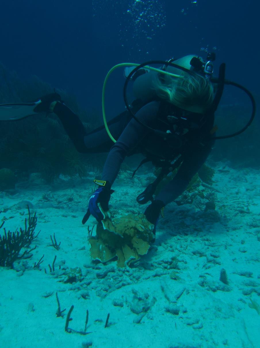
1 Bonaire National Marine Park Hurricane Matthew Reef Damage Assessment Hurricane Matthew passed north of Bonaire on September 23 rd, After it passed Aruba, it decelerated, and then it slowly began heading north-northeast (Figure 1), causing waves to start heading towards Bonaire. On September 29 th, waves from Hurricane Matthew reached the leeward shore of Bonaire. The largest waves (3.1 m according to Windguru, Appendix 1) reached Bonaire on the evening of September 29 th and larger waves (larger than 2 m) continued to hit parts of the leeward shore of Bonaire on September 30 th. Immediately after the waves subsided, STINAPA sent survey forms to dive operators requesting information on reef conditions as well as offering to assist in removing large debris. Bonaire National Marine Park rangers took photos of damage to piers, docks, ladders, etc. and began removing large debris from the reef. On October 6 th, 2016, STINAPA staff, interns and volunteers began surveying sites along the leeward shore of Bonaire to assess reef condition. Figure 1. Path of Hurricane Matthew Methodology A total of 18 sites were surveyed. At each site, a 20 m x 4 m area was surveyed at three depths (20m, 10m and less than 10m). In each transect, the total number of corals and the number of broken and/or toppled corals in three size classes (>10 and
2 <30 cm, 30 cm 100 cm, and >100 cm in diameter) was recorded. The total number of sponges and damaged sponges was also recorded in each transect. Observers also estimated the percent of sand/silt covering living coral tissue and made general observations at depths of 30 m, 20 m, 10 m and less than 10 m. Additionally, divers fanned sponges and righted toppled corals when possible. Results The corals at depths of 10 m and deeper were mostly undamaged (Figure 2, Appendix 2). In the shallows (less than 10 m depth), an average of 25% of the coral colonies were damaged (Figure 3). Most of the damaged corals were fire corals (Millepora complanata). Several stands of branching corals (Acropora species) were also reported as damaged. Smaller colonies (between 10 and 30 cm in diameter) were damaged more than larger colonies (Figure 4) and this supports the written observations that many of the larger boulder/mound corals were undamaged in the shallows. Although eight sites had no sponge damage in the survey areas, the average sponge damage at all sites and depths was 12% with little difference by depth (Figure 3, Figure 5 and Appendix 2). Sponges, if they don t move about, may reattach to the substrate and continue growing. From general observations and photo documentation, there were many sites where the sand in the shallows had been scoured away and seemed to be flocking the rest of the reef. A week after the heaviest wave action, most of the corals had cleaned themselves of the sand cover. There was an average of less than five percent sand/silt covering corals at all depths. Corals, unless smothered, are often able to clean themselves using their tiny cilia. Figure 2. Percent corals damaged at three different depths at eighteen locations on the western shore of Bonaire and Klein Bonaire.


3 Figure 3. Overall Percent Damage of Corals and Sponges and Sand Cover by Depth. Overall % Damage and Sand Cover by Depth Corals Sponges Sand/Silt <10 m 10 m 20 m

4 Figure 4. Percent of small (>10 and <30 cm), medium ( cm) and large (> 100 cm) coral colonies damaged at three different depths. Percent Coral Colonies Damaged by Size Class and Depth <10 m 10 m 20 m % small colonies % medium colonies % large colonies Figure 5. Percent sponges damaged at three different depths at eighteen locations on the western shore of Bonaire and Klein Bonaire.
5 Conclusions Bonaire has had a series of impacts to its leeward reefs in recent years. In 1999, waves from Lenny completely destroyed many of the shallow coral reefs of Bonaire, causing particular damage to branching corals. Some sites that had high coral cover before Lenny were completely bare down to a depth of 15 m. Lenny changed the underwater landscape of the island. In 2008, waves from Tropical storm Omar hit the leeward coast and also caused extensive damage to depths of 10m and more and some sites, also heavily damaging branching corals. The results of this damage assessment show that, although the waves from Hurricane Matthew damaged an average of 25% of shallow corals (less than 10 m deep) and 10% of sponges on the leeward side of the island, Bonaire s corals were mostly undamaged. The sites that showed the most damage in the shallows were some of the same sites that had been damaged by previous storms (Lenny, Omar) and many of the broken corals were fire corals (Millepora complanata). Although most of Bonaire s corals were spared from breakage and toppling, coral recovery at some of the sites most heavily hit by Lenny and Omar was reset and must begin anew. Also, there may be indirect effects of these types of disturbances
, and a decrease in immunity of corals due to stress, possibly resulting in more susceptibility to disease.")
6 such as nutrients being released from the sediment/sand into the water column, death of small corals or coral recruits from abrasion of sand and/or rubble (small corals were not included in this assessment), and a decrease in immunity of corals due to stress, possibly resulting in more susceptibility to disease. Coral reefs are declining in most areas of the world and climate change is predicted to result in more storms and more coral bleaching events. Doing everything possible at the local level to safeguard Bonaire s coral reefs is essential. October 11 th, 2016 Prepared by: Caren Eckrich and Hannah Rempel STINAPA Bonaire Appendix 1. Archive data from Windguru for Bonaire. Appendix 2. Percent coral and sponge damage by depth at each site. Percent Coral Damage Depth <10m 10m 20m
7 Bachelor's Beach 43.33% 1.59% 0.00% Bellafonte 20.00% 0.00% 0.00% Bise Morto, WSNP 60.00% 14.06% 3.13% Boka Bartol, WSNP 38.30% 4.88% 0.00% Boka Slagbaai, WSNP 17.86% 8.57% 4.17% Buddy's Reef 86.05% 2.13% 0.00% Forest, Klein 0.00% 0.00% 0.00% Jeff Davis 0.00% 0.00% 0.00% Karpata Reserve 0.00% 0.00% 0.00% Mi Dushi, Klein 51.28% 37.50% 0.00% Monte's Divi 0.00% 0.00% 0.00% Ol' Blue 0.00% 0.00% 0.00% The Lake 25.93% 1.32% 0.00% Small Wall 0.00% 0.00% 0.00% Tori's Reef 79.17% 5.13% 0.00% Vista Blue 13.33% 0.00% 0.00% White Slave 0.00% 0.00% 0.00% Windsock 27.91% 1.45% 0.00% Percent Sponge Damage Depth <10m 10m 20m Bachelor's Beach 0.00% 0.00% 0.00% Bellafonte 0.00% 0.00% 0.00% Bise Morto, WSNP 50.00% 50.00% 0.00% Boka Bartol, WSNP 0.00% 16.67% 0.00% Boka Slagbaai, WSNP 40.00% 26.32% 33.33% Buddy's Reef 1.00% 62.50% 21.43% Forest, Klein 0.00% 0.00% 21.43% Jeff Davis 0.00% 0.00% 0.00% Karpata Reserve 0.00% 0.00% 0.00% Mi Dushi, Klein 33.33% 0.00% 0.00% Monte's Divi 0.00% 0.00% 0.00% Ol' Blue 0.00% 0.00% 0.00% The Lake 0.00% 0.00% 0.00% Small Wall 0.00% 20.00% 0.00% Tori's Reef 1.00% 33.33% 0.00% Vista Blue 13.33% 0.00% 0.00% White Slave 0.00% 0.00% 23.53% Windsock 0.00% 0.00% 0.00%

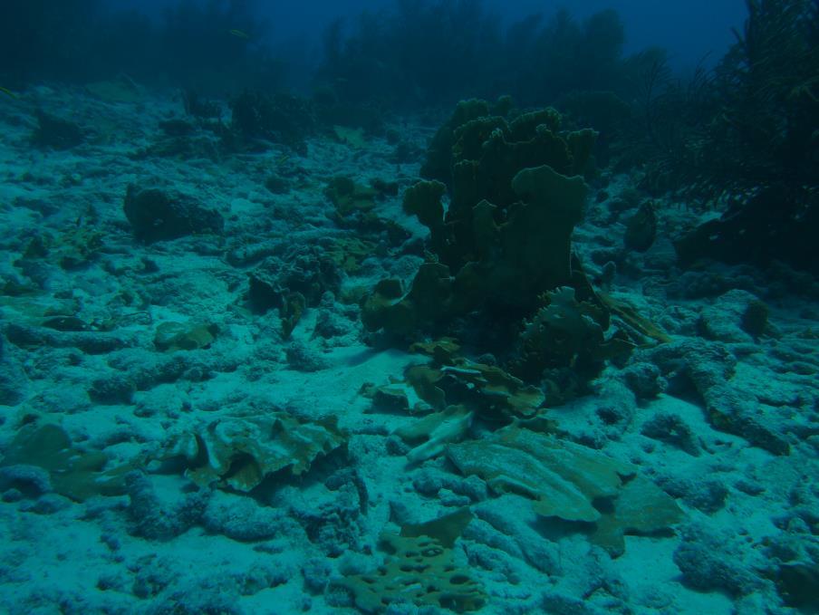
8 Photo documentation: Sand/silt covering all but living coral at 30 m. Sand and silt covering sponge.


9 Sand piling up against coral.


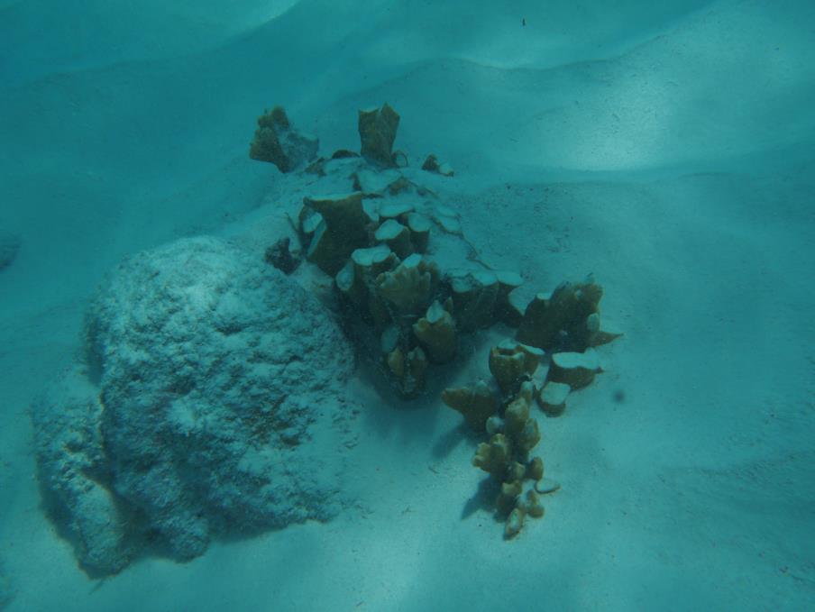
10 Sand scoured away from shallow sites exposing old dead corals. Diver doing 30 x 2 m survey.

11 Diver attempting to right toppled fire coral.
12

13 Diver fanning sand/silt off sponge.

14 Broken fire coral (Millepora complanata).
15
Reef Check Australia. Magnetic Island Season Report 2016
 Reef Check Australia Season Report 16 Reef Check Foundation Ltd. (Australia) www.reefcheckaustralia.org PO Box 134 George St Brisbane QLD 43 This report should be cited as: M. Welch, J. Salmond and J.
Ghost (net) Busters. Ghost Net Retrieval. Time to complete lesson: minutes
 Busters. Ghost Net Retrieval. Time to complete lesson: minutes") Ghost (net) Busters Ghost Net Retrieval Time to complete lesson: 20-30 minutes Purpose of module: This module allows students to simulate the removal of a derelict fishing net from a model coral reef.
Ghost (net) Busters Ghost Net Retrieval Time to complete lesson: 20-30 minutes Purpose of module: This module allows students to simulate the removal of a derelict fishing net from a model coral reef.
Can Corals Survive In A Warming World?
 Published August 11, 2009 Can Corals Survive In A Warming World? by Richard Harris Mark Vermeij Glassy sweepers are small nervous fish that can cluster in groups of 100 or more. When they're young, their
The Surge of the Storm By Margaret Olsen and Katie Greganti
 The Surge of the Storm By Margaret Olsen and Katie Greganti Grade Level: 5-12 Type of Activity: Hands on Focus Question: How does a hurricane s storm surge of a hurricane affect the low-lying areas along
Nature Foundation Marine Park, Reef & Marine Research Assessments Post Hurricane Irma
 Nature Foundation Marine Park, Reef & Marine Research Assessments Post Hurricane Irma Melanie Meijer zu Schlochtern Project Officer Nature Foundation St Maarten 24 November 2017 - ongoing Hurricane Irma
Reef Check Australia 2009 Great Barrier Reef Survey Season Report
 Reef Check Australia 2009 Great Barrier Reef Survey Season Report Supported by the Australian Government s Marine and Tropical Sciences Research Facility Project 1.1.2 Condition and trend of the Great
3.9 FROM ISLANDS TO ATOLLS
 3.9 1 3.9 FROM ISLANDS TO ATOLLS OBJECTIVES The students Listen to a description of the formation of volcanic islands, fringing reefs, barrier reefs, and atolls. Observe and participate in a simulation
Boulder Island Coral Survey. Project Manaia. Phase one - Final Report
 Boulder Island Coral Survey Project Manaia Phase one - Final Report Thor Jensen & Annika Dose January 2018 Content 1. Coral genera and their abundance in the bays of Boulder Island...3 2. Reef maps...5
ACT NOW for the future of our reefs
 Do It Yourself Kit WWW.CORALWATCH.ORG ACT NOW for the future of our reefs Rising water temperatures are a major contributor to mass coral bleaching events. Get involved in CoralWatch to monitor and protect
John Brewer Reef Sunferries-Townsville
 John Brewer Reef Sunferries-Townsville Latitude: 18 57.364S Longitude: 146 57.375E Date: 31-1-4, 1-2-4 and 24.3.4 Florent Cade 24 SITE DESCRIPTION John Brewer Reef is a mid shelf reef situated approximately
Determining coral reef impacts associated with boat anchoring and user activity
 Determining coral reef impacts associated with boat anchoring and user activity Protect Our Reefs Grant Interim Report October 1, 2008 March 31, 2009 Donald C. Behringer 1, Thomas K. Frazer 1, Robert A.
Overview. What are Corals?
 Overview Coral Reefs extend back over 500 m.y. Grow in tropical seas with normal salinity Support a great variety of plant and animal life Cover less than 0.2% of sea floor Contain about 25% of marine
Kuwait Dive Team's Report of Coral Bleaching in the Reefs of the State of Kuwait
 Kuwait Dive Team's Report of Coral Bleaching in the Reefs of the State of Kuwait 19/09/2009 Created by: Kuwait Dive Team Guardians of the Sea, Kuwait Dive Team (KDT) resumed the inspection tours for the
Resort and Dive Operation Management, Marine Biology Support, Programmes and Training.
 Helen Sykes & Stuart Gow Mail: PO Box 2558 Government Buildings SUVA, Fiji Islands Tel: (679) 336 3625 or 359 2136 Email: resortsupport@connect.com.fj Resort and Dive Operation Management, Marine Biology
SEASFIRE Introduction explore discover create
 SEASFiRE MX2 March 2018 2 SEASFIRE Introduction SEASFiRE organizes citizen science, marine education, and adventure programs which enable you to explore nature, discover the world around you, and create
Great Barrier Reef: Bleaching 'kills 35% of area's coral' 8 hours ago From the section Australia
 Great Barrier Reef: Bleaching 'kills 35% of area's coral' 8 hours ago From the section Australia Image copyright AFP Image caption The recovery of coral cover is expected to take a decade or longer, scientists
Reef Watch Guidelines
 Reef Watch Guidelines What is Reef Watch? Reef watch is a simple one-dive-one-survey method to record the health of coral reefs. The method is easily learnt and it is even easier to participate in the
STATUS REPORT FOR THE SUBMERGED REEF BALL TM ARTIFICIAL REEF SUBMERGED BREAKWATER BEACH STABILIZATION PROJECT FOR THE GRAND CAYMAN MARRIOTT HOTEL
 August 23 STATUS REPORT FOR THE SUBMERGED REEF BALL TM ARTIFICIAL REEF SUBMERGED BREAKWATER BEACH STABILIZATION PROJECT FOR THE GRAND CAYMAN MARRIOTT HOTEL performed by Lee E. Harris, Ph.D., P.E. Consulting
Coral Reefs N Q U. Visit for thousands of books and materials.
 Coral Reefs A Reading A Z Level N Leveled Book Word Count: 615 N Q U Written by Paula Schricker Visit www.readinga-z.com for thousands of books and materials. www.readinga-z.com Photo Credits: Front cover:
Determining Coral Reef Impacts Associated with Boat Anchoring and User Activity in Southeast Florida
 Determining Coral Reef Impacts Associated with Boat Anchoring and User Activity in Southeast Florida Southeast Florida Coral Reef Initiative Fishing, Diving, and Other Uses Local Action Strategy Project
Citizen Science Based Survey GBR Far North Dive Trip 2016 April 18-26
 Citizen Science Based Survey GBR Far North Dive Trip 2016 April 18-26 Chris Roelfsema Karen Johnson Douglas Stetner Trevor Baerenger Peran Brady May 2016 GBR Far North Citizen Science Trip 5 May 2016 1
 ROV Transects of Deep Sea Coral Communities Habitat Type, Species Abundance and Diversity The teacher may choose to explore species abundance and diversity in deep sea coral communities in several different
Great Barrier Reef: Two-thirds damaged in 'unprecedented' bleaching
 Great Barrier Reef: Two-thirds damaged in 'unprecedented' bleaching Image copyright ARC CENTRE OF EXCELLENCE FOR CORAL REEF STUDIES Image caption Bleaching occurs when warmer temperatures drive out colour-giving
OBSERVING CORALS and ALGAE:
 5 OBSERVING CORALS and ALGAE: MANTA TOW, SNORKEL SURVEY, and POINT-INTERCEPT TRANSECT A. Manta Tow Definition A manta tow survey is the observation of an underwater area of good visibility by a snorkeler
Mass coral mortality under local amplification of 2 C ocean warming
 Mass coral mortality under local amplification of C ocean warming Thomas M. DeCarlo, Anne L. Cohen, George T.F. Wong, Kristen A. Davis, Pat Lohmann, Keryea Soong correspondence to: tdecarlo@uwa.edu.au
STATUS OF REEFS AROUND MAGNETIC ISLAND: REEF CHECK AUSTRALIA
 STATUS OF REEFS AROUND MAGNETIC ISLAND: 2003-2006 REEF CHECK AUSTRALIA Zoë Andrews Loren Hartley Jos Hill April 2006 1 INTRODUCTION The purpose of this project was to engage Townsville community members
Reef Check Australia South East Queensland Survey Season Summary
 2009 Reef Check Australia South East Queensland Survey Season Summary Ian Banks Jennifer Loder Reef Check Foundation Ltd Reef Check Australia greatly appreciates all of the people and organizations who
Seagrasses of the Virgin Islands
 Seagrasses of the Virgin Islands Seagrasses are flowering plants that live underwater. These marine plants resemble the land species of grasses in that they have long blade-like leaves. Seagrasses grow
Oceans Humans both depend on it and threaten it with their activities
 Oceans Humans both depend on it and threaten it with their activities Oceans Water covers nearly ¾ of the Earth s surface More than 50% of the world s population lives within an hour of the coast Oceans
Haitian Curriculum Fourth Grade Science Lesson Plan Coral Reefs in Haiti
 Haitian Curriculum Fourth Grade Science Lesson Plan Coral Reefs in Haiti Content/Theme: Coral Reefs in Haiti/Ecosystems Grade: Fourth Primary Benchmark: SC.4.L.17.4 Recognize ways plants and animals, including
FLAGLER BEACH PIER POST INCIDENT SAFETY INSPECTION HURRICANE IRMA SEPTEMBER 15-17, 2017
 LOGAN DIVING & SALVAGE 2815 SAINT JOHNS BLUFF JACKSONVILLE, FLORIDA 32246 TEL: (904) 731-0000 FAX: (904) 731-5493 MARINE SPECIALTY CONTRACTOR FL SCC131151014 FLAGLER BEACH PIER POST INCIDENT SAFETY INSPECTION
DURING ALL ACTIVITIES, MAKE SURE YOU DON T DAMAGE THE REEF OR OTHER MARINE LIFE!
 Fish surveys Long term volunteers can take part in the fish surveys. These surveys are the most complex research we do with volunteers. You have to learn a lot, but in return you will receive a lot of
Marine Ecosystems. Aquatic Ecosystems Section 2
 Marine Ecosystems Marine ecosystems are located mainly in coastal areas and in the open ocean. Organisms that live in coastal areas adapt to changes in water level and salinity. Organisms that live in
4 Reef Watch Guidelines
 11 4 Reef Watch Guidelines Reef watch is a simple one-dive-one-survey method to record the health of a coral reef. You can easily learn the method and take part in the programme. On your dive or snorkel
The Wide Spread Negative Effects of Exposure to Excess Nutrients for Coral Reefs
 The Wide Spread Negative Effects of Exposure to Excess Nutrients for Coral Reefs Introduction: The majority of the Earth we live on is underwater, yet we know so little about life below the surface. It
Status of Curaçao s Reefs
 References can be found in BioNews Issue 4 Map of Curaçao. Image credit: DCNA The island of Curaçao is almost entirely surrounded by narrow fringing reef that covers an estimated area of 7.85 km2 (Vermeij,
DIVE 1: UNDERWATER EXPLORER
 DIVE 1: UNDERWATER EXPLORER Summary This lesson introduces students to the marine habitat and the wealth and diversity of life found in the ocean. Students will learn about how scientists explore underwater,
The Movement of Ocean Water. Currents
 The Movement of Ocean Water Currents Ocean Current movement of ocean water that follows a regular pattern influenced by: weather Earth s rotation position of continents Surface current horizontal movement
Great Barrier Reef Season Summary Report 2014 Reef Check Foundation Ltd Annie Bauer Edited by Jennifer Loder
 Reef Check Australia Great Barrier Reef Season Summary Report 214 Reef Check Foundation Ltd Annie Bauer Edited by Jennifer Loder www.reefcheckaustralia.org Reef Check Australia This project is supported
Assessment of Artificial Reefs Impacted by Hurricane Michael
 Assessment of Artificial Reefs Impacted by Hurricane Michael Jeff Renchen, Keith Mille, Devin Resko, Christine Kittle Florida Fish and Wildlife Conservation Commission Division of Marine Fisheries Management
COASTAL HAZARDS. What are Coastal Hazards?
 COASTAL HAZARDS What are Coastal Hazards? Hazards in the New Jersey coastal zone include unavoidable risks to life and property generated by: coastal flooding, waves, high winds and waves, short-term and
Cool Coral Facts. coral_reef_1.jpg
 Corals Background Cool Coral Facts http://oceanworld.tamu.edu/students/coral/images/ coral_reef_1.jpg 1. One of the oldest ecosystems on Earth 2. Largest living structure on Earth 3. Without coral reefs,
Reef Check Australia Moreton Bay Oil Spill Monitoring Report Prepared for: SEQ Catchments Ltd
 2009 Reef Check Australia Moreton Bay Oil Spill Monitoring Report Prepared for: SEQ Catchments Ltd Ian Banks Reef Check Foundation Ltd Geoffrey M. Cook, statistical analysis Jody Kreuger, editor 2 Jennifer
MAHS Field School 2018 Pickles Reef Florida Keys National Marine Sanctuary
 MAHS Field School 2018 Pickles Reef Florida Keys National Marine Sanctuary MAHS returned to Pickles Reef in June of 2018 to hold its annual field school. Pickles Reef lies about 6 miles from Key Largo
Unit 11 Lesson 2 How Does Ocean Water Move? Copyright Houghton Mifflin Harcourt Publishing Company
 Unit 11 Lesson 2 How Does Ocean Water Move? Catch a Wave A wave is the up-and-down movement of surface water. Catch a Wave Catch a Wave (wave effects) Surface waves are caused by wind pushing against
INVESTIGATING VARIATIONS IN CORAL REEF MORPHOLOGY WITH PHOTOMOSAICS AND ANALYSIS OF PERCENT COVER
 INVESTIGATING VARIATIONS IN CORAL REEF MORPHOLOGY WITH PHOTOMOSAICS AND ANALYSIS OF PERCENT COVER by JUSTIN CULMAN A THESIS Presented to the Environmental Studies Program of the University of Oregon In
Ocean Exploration and Human Impact. By: Carly Coupal, Logan Hoeppner, and Sydney McMichael
 Ocean Exploration and Human Impact By: Carly Coupal, Logan Hoeppner, and Sydney McMichael Scuba Divers Scuba divers are people that wear underwater suits and have air tanks called an breathing apparatus
UNDERWATER BRIDGE INSPECTION REPORT STRUCTURE NO CSAH 4 OVER THE BEAVER RIVER ST. LOUIS COUNTY
 UNDERWATER BRIDGE INSPECTION REPORT STRUCTURE NO. 7635 CSAH 4 OVER THE BEAVER RIVER ST. LOUIS COUNTY JUNE 18, 2012 PREPARED FOR THE MINNESOTA DEPARTMENT OF TRANSPORTATION BY COLLINS ENGINEERS, INC. JOB
Night Diving. Why night dive? The preparations. Keeping track of where you are. Handling equipment
 Night Diving Why night dive? The preparations Keeping track of where you are Handling equipment Night Diving The preparations Keeping track of where you are Handling equipment Night Diving Why night dive:
STATUS OF REEFS AROUND MAGNETIC ISLAND:
 STATUS OF REEFS AROUND MAGNETIC ISLAND: 2003-2007 REEF CHECK AUSTRALIA Zoë Andrews Loren Hartley Jos Hill Revised by Steven Prutzman Tara Swansborough Jos HIll February 2008 TABLE OF CONTENTS STATUS OF
Keywords: marine habitat recovery, derelict fishing gear
 Marine habitat recovery after derelict fishing net removal. Jeff June*, Kyle Antonelis, Natural Resources Consultants, Inc. Seattle, WA. *Corresponding author: jjune@nrccorp.com Keywords: marine habitat
Seahorse (Hippocampus spp.) hotspots and habitat associations in Thailand
 hotspots and habitat associations in Thailand") Seahorse (Hippocampus spp.) hotspots and habitat associations in Thailand Tse-Lynn Loh, Lindsay Aylesworth, Sarah Foster & Chuck Knapp Shedd Aquarium & Project Seahorse Funky Fish Seahorses under threat
Seahorse (Hippocampus spp.) hotspots and habitat associations in Thailand Tse-Lynn Loh, Lindsay Aylesworth, Sarah Foster & Chuck Knapp Shedd Aquarium & Project Seahorse Funky Fish Seahorses under threat
Improving fishermen awareness to reduce the presence of lobster traps in MPAs of the Florida Keys. Gabrielle Renchen & Tom Matthews
 Improving fishermen awareness to reduce the presence of lobster traps in MPAs of the Florida Keys Spiny Lobster Advisory Panel Meeting Key Largo, FL April 25, 2016 Gabrielle Renchen & Tom Matthews Florida
APPENDIX H PLUME MODELS
 APPENDIX H PLUME MODELS APPENDIX H PLUME MODELS Prior to the initiation of recovery activities, the National Oceanic and Atmospheric Administration ran a series of oil plume trajectory analyses (2001a)
SCHOOLING BEHAVIOR OF HAEMULON SPP. IN BERMUDA REEFS AND SEAGRASS BEDS
 SCHOOLING BEHAVIOR OF HAEMULON SPP. IN BERMUDA REEFS AND SEAGRASS BEDS Hillary, Department of Biology,, Worcester, MA 01610 (hisullivan@clarku.edu) Abstract Schooling behavior is common among many different
Reef Check Monitoring and COTs Control in Palu Bay Central Sulawesi, Indonesia: Earth Day 2007 Activity Repo rt
 Reef Check Monitoring and COTs Control in Palu Bay Central Sulawesi, Indonesia: Earth Day 7 Activity Repo rt By: Yayasan Palu Hijau (YPH) and STPL-Palu (LP3M & MAPALA) Supported by Yayasan Reef Check Indonesia
Junior Park Warden Reef Discovery Site
 Junior Park Warden Reef Discovery Site Reef Ball Restoration Project 2012 Sponsored by: Submitted By: Marsha Pardee and John Walch September 11, 2012 1 P a g e For 5 days in June 2012, Marsha Pardee and
UNDERSTANDING STORM SURGE
 The Education Program at the New Jersey Sea Grant Consortium 22 Magruder Road, Fort Hancock, NJ 07732 (732) 872-1300 www.njseagrant.org UNDERSTANDING STORM SURGE ACTIVITY 6 SURGE OF THE STORM http://secoora.org/classroom/virtual_hurricane/surge_of_the_storm>
FIGURE 1. TOTAL LENGTH OF FISH, IN THIS CASE A PILE PERCH, IS MEASURED FROM MOUTH TO TIP OF TAIL (ILLUSTRATION LARRY G. ALLEN).
.") Fish Transect Updates- 2013 Sizing Fish Before discussing how to size fish underwater, we must have a picture of what we are measuring. For the purposes of Reef Check California, we will be measuring total
Fish Transect Updates- 2013 Sizing Fish Before discussing how to size fish underwater, we must have a picture of what we are measuring. For the purposes of Reef Check California, we will be measuring total
Do you have any reef related concerns or specific problems you would like to share?
 Submitted County Do you have any reef related concerns or specific problems you would like to share? Do you have any suggestions about how to Improve the Our Florida Reefs Community Planning Process? What's
UNDERWATER BRIDGE INSPECTION REPORT STRUCTURE NO CSAH 133 OVER A DITCH ST. LOUIS COUNTY
 UNDERWATER BRIDGE INSPECTION REPORT STRUCTURE NO. 7780 CSAH 133 OVER A DITCH ST. LOUIS COUNTY SEPTEMBER 27, 2012 PREPARED FOR THE MINNESOTA DEPARTMENT OF TRANSPORTATION BY COLLINS ENGINEERS, INC. JOB NO.
CMS Modeling of the North Coast of Puerto Rico
 CMS Modeling of the North Coast of Puerto Rico PRESENTED BY: Dr. Kelly Rankin Legault, Ph.D., P.E. 1 Dr. Alfredo Torruella, Ph.D. 2 1 USACE Jacksonville District 2 University of Puerto Rico October 2016
Experimental reestablishment of populations of the long spined sea urchin, Diadema antillarum, on two small patch reefs in the upper Florida Keys
 Principal Investigator Ken Nedimyer 212 Silver Palm Avenue Tavernier, FL 33070 phone (305) 852-4955, fax (305) 852-3500 email, sealife@terranova.net Associate Investigator Martin A. Moe, Jr. 222 Gulfview
WHALE SHARK (Rhincodon typus) RECOVERY PLAN
 RECOVERY PLAN") WHALE SHARK (Rhincodon typus) RECOVERY PLAN 2004-2009 Great Barrier Reef Marine Park Authority Background The whale shark (Rhincodon typus) is the world s largest fish, and one of only 3 filter-feeding
WHALE SHARK (Rhincodon typus) RECOVERY PLAN 2004-2009 Great Barrier Reef Marine Park Authority Background The whale shark (Rhincodon typus) is the world s largest fish, and one of only 3 filter-feeding
SCRIPPS AQUARIUM WORKSHEET Spring 2006 Name updated 4/28/06 FOR CREDIT TURN IT IN TO YOUR PROFESSOR AT THE END OF CLASS INSTRUCTIONS:
 SCRIPPS AQUARIUM WORKSHEET Spring 2006 Name updated 4/28/06 FOR CREDIT TURN IT IN TO YOUR PROFESSOR AT THE END OF CLASS INSTRUCTIONS: This worksheet will help you to observe some of the fascinating exhibits
Volume and Shoreline Changes along Pinellas County Beaches during Tropical Storm Debby
 Volume and Shoreline Changes along Pinellas County Beaches during Tropical Storm Debby Ping Wang and Tiffany M. Roberts Coastal Research Laboratory University of South Florida July 24, 2012 Introduction
Volunteering in the Virgin Islands. 7 Days
 Volunteering in the Virgin Islands 7 Days Volunteering in the Virgin Islands Discover the unspoiled beauty of St. John, the smallest of the Virgin Islands. This trip has all the highlights of a Caribbean
Lee E. Harris, Ph.D., P.E. Assoc. Professor of Ocean Engineering. Doug Bowlus and Ashley Naimaster Ocean Engineering Graduate Students
 FLORIDA TECH OCEAN ENGINEERING PROFESSOR LEE HARRIS AND HIS GRADUATE STUDENTS ASSIST WITH POST-HURRICANE IVAN CORAL REEF RESTORATION IN THE CAYMAN ISLANDS Lee E. Harris, Ph.D., P.E. Assoc. Professor of
SALINITY. It's the amount of dissolved salts the water contains.
 AQUATIC ECOSYSTEMS SALINITY The types of organisms in an aquatic ecosystem depend upon the water s Salinity. It's the amount of dissolved salts the water contains. Salinity determines the two main aquatic
Chapter 5 Decompression, Dive Tables, and Dive Computers
 Chapter 5 Decompression, Dive Tables, and Dive Computers Nitrogen and Diving 1. If the partial pressure of nitrogen in the air you are breathing is greater than the pressure of nitrogen in your body, your
Florida Seagrass Integrated Mapping and Monitoring Program
 Florida Seagrass Integrated Mapping and Monitoring Program - 2004 The following document is composed of excerpts taken from the 2011 publication, Seagrass Integrated Mapping and Monitoring for the State
Ocean Series Coral Reefs
 Ocean Series Coral Reefs Coral is part of the animal kingdom, a member of the scientific phylum Cnidaria along with other marine creatures including sea jellies. Sea jellies have a soft gelatinous body
Recovery of Coral Populations at Helen Reef Atoll after a Major Bleaching Event
 Recovery of Coral Populations at Helen Reef Atoll after a Major Bleaching Event Yimnang Golbuu 1, Jay Andrew 1, Geory Mereb 1, Robert van Woesik 2 1 Palau International Coral Reef Center 2 Florida Institute
Alan Davis Field Trip Activities
 Alan Davis Field Trip Activities Establish your sampling group. Groups should be no larger than four students. Obtain an assigned sampling region and a bucket with a variety of tools for sampling. Other
Chapter 1: The Rocky Intertidal: Disturbance and Diversity Pirates of the Intertidal: On stranger Tides. By: Connor Rooks and Austin Grace.
 Chapter 1: The Rocky Intertidal: Disturbance and Diversity Pirates of the Intertidal: On stranger Tides By: Connor Rooks and Austin Grace Introduction Abstract In our study, we investigated the intermediate
Coral Snapshots: Biodiversity in Marine Protected Areas A Classroom Activity for Ocean Gazing Episodes 4 & 44: Sonar in the sea; ROVers over and under
 Coral Snapshots: Biodiversity in Marine Protected Areas A Classroom Activity for Ocean Gazing Episodes 4 & 44: Sonar in the sea; ROVers over and under Written by: Christopher J. Petrone and Noelle J. Relles,
St Vincent. Grenadines. Wise practices for coping with. and the. i b bea n Se a
 Wise practices for coping with St Vincent Car i b bea n Se a and the Grenadines Bequia Community High School, Bequia, St Vincent and the Grenadines Ministry of Agriculture, Lands and Fisheries, St Vincent
Ocean Motion Notes. Chapter 13 & 14
 Ocean Motion Notes Chapter 13 & 14 What is a Wave? Wave: movement of energy through a body of water How are Waves Caused? Caused mostly by wind Wind blowing on the water transmits energy to the water Size
Firth of Lorn Sea Fan Surveys
 Firth of Lorn Sea Fan Surveys 2007-2009 The Northern Sea Fan Project the east coast of the Western Isles. However, the comparatively low number of records will be largely due to the lack of data from exposed
While the fishing standing stock at Wheeler North Reef has been consistently below the 28 ton requirement, data from last summer s survey showed that
 1 While the fishing standing stock at Wheeler North Reef has been consistently below the 28 ton requirement, data from last summer s survey showed that it increased by 88% in 2014. This raises the question
* Appalachian Mountains -the mountain range in the Eastern U.S. which terminates in north-central Alabama
 MR. SAND TEACHER'S MANUAL INTRODUCTION: Although Mr. Sand is a cartoon presentation that is attractive to children (of all ages), the material is technically accurate and quite significant to our understanding
Pre and Post Dredging Coral Health Monitoring
 Pre and Post Dredging Coral Health 11/08/16 Level 31, 12 Creek St Brisbane QLD 4000 Australia 301310-09660-00-EN-REP-0003 www.advisian.com Disclaimer This report has been prepared on behalf of and for
Productivity, Energy, and Resources. Symbiosis. Commensalism Mutualism Parasitism. Commensalism
 Productivity, Energy, and Resources Symbiosis Commensalism Mutualism Parasitism Commensalism Hitching a ride Using an organism for shelter Using abandoned parts after death (hermit crabs) http://www.scubaduba.com/gallery/shark2.jpg
UNDERWATER BRIDGE INSPECTION REPORT STRUCTURE NO OVER THE STRAIGHT RIVER DISTRICT 6 - RICE COUNTY
 UNDERWATER BRIDGE INSPECTION REPORT STRUCTURE NO. 66513 14 th STREET (MSAS NO. 103) OVER THE STRAIGHT RIVER DISTRICT 6 - RICE COUNTY PREPARED FOR THE MINNESOTA DEPARTMENT OF TRANSPORTATION BY COLLINS ENGINEERS,
Comparison of Coral Diversity Across Three Reef Habitats
 Biodiversity of Borneo Project 2: Coral Reefs Coral Diversity Study Comparison of Coral Diversity Across Three Reef Habitats Marcel Alfasisurya.S.A, Ross McFarland, Charlie Ryland, Olivia Tandon, Kore
Reef Check Australia. Great Sandy Marine Park Reef Health Survey Report 2017
 Reef Check Australia Great Sandy Marine Park Reef Health Survey Report 2017 Reef Check Foundation Ltd M. Welch, J. Salmond. J. Passenger and J. Loder www.reefcheckaustralia.org March 2018 We acknowledge
TRACKING LIFE ON THE REEF Monitoring Benthic Communities in FKNMS No-Take Management Zones
 TRACKING LIFE ON THE REEF Monitoring Benthic Communities in FKNMS No-Take Management Zones Steven Miller 1, Mark Chiappone 1, Leanne Rutten 1 Jerry Ault 2, Steve Smith 2 1 Nova Southeastern University
Shoreline Erosion Control Failures and How To Avoid Them
 2008 Illinois Lake Management Association Shoreline Erosion Control Failures and How To Avoid Them by: Hank Sutton, President, Lake Rip Rap, Inc. www.lakeriprap.com - www.macoupinboats.com Setting the
Concepts & Phenomena
 Concepts & Phenomena in coastal and port sedimentation R. Kamalian Ports and Maritime Organization of Iran and PIANC-Iran 7 9 December 2015 What is the problem? Many harbours have sedimentation problems
Coastal management has lagged behind the growth in population leading to problems with pollution
 Fifty percent of the population of the industrialized world lives within 100 km of a coast. Coastal management has lagged behind the growth in population leading to problems with pollution and natural
Beach Profiles: Monitoring Sea Level Rise. Student Activity Sheet. Name Date Class
 Beach Profiles: Monitoring Sea Level Rise Student Activity Sheet Name Date Class A shoreline is the area where the water and land meet. This is where we find beach: areas where sediments (sand or other
Habitat Fact Sheets. Rocky habitats are dominated by seaweeds and often mussels, which rely on the rocks for attachment.
 Habitat Fact Sheets Habitats in the Gulf of Maine serve many important roles for the environment and for humans as well. These include: cycling nutrients, filtering pollution, trapping sediments, storing
QuickTime and a decompressor are needed to see this picture.
 QuickTime and a decompressor are needed to see this picture. The future of the Florida Keys? Jeremy Jackson Scripps Institution of Oceanography & Smithsonian Tropical Research Institute Coral reefs in
SCRIPPS BIRCH AQUARIUM WORKSHEET
 SCRIPPS BIRCH AQUARIUM WORKSHEET Name 1. Read over the Student Learning Outcomes and associated General Questions on this page, and refer back and take notes on this page as you walk through the aquarium,
satellite image Penjalin (30th Nov - 2nd Dec 2006) N E
 N E") Page 1 Penjalin (30th Nov - 2nd Dec 2006) N E SV Infinity's anchorage rocks with fringing reef, west side Penjalin Besar bay on east side Penjalin Besar 22.1910' 22.8764' 20.5266' Penjalin Besar: beach
Page 1 Penjalin (30th Nov - 2nd Dec 2006) N E SV Infinity's anchorage rocks with fringing reef, west side Penjalin Besar bay on east side Penjalin Besar 22.1910' 22.8764' 20.5266' Penjalin Besar: beach
Annex E Bridge Pier Protection Plan
 Annex E Bridge Pier Protection Plan Table E1 Bridge Types and Locations Table E2 Flow Conditions For River Sections Figure E1 Bridge Abutment Protection Figure E2 Bridge Pier Protection Figure E3 Central
Environmental. Effects of Dredging
 Envi~onmental Effects of Dredging Technical Notes THE VALUE OF GRAVEL DISPOSAL MOUNDS IN RIVER SIDE CHANNELS FOR FRESHWATER MUSSELS PURPOSE: This note provides information on the value of gravel disposal
ISLAND RESOLUTION MARINE PARK BONAIRE
 ISLAND RESOLUTION MARINE PARK BONAIRE NOTE: This translation of the Island Resolution Marine Park Bonaire has been prepared to assist interested parties in understanding the content of this resolution.
Ecological Processes and Coral Reef Recovery in the Florida Keys
 Final 2 October 26 Ecological Processes and Coral Reef Recovery in the Florida Keys Struan R. Smith (Bermuda Biological Station for Research, Inc., St. George s GE, Bermuda) Richard B. Aronson and Thaddeus
REEF COMMUNITIES AFTER THE 2010 MASS CORAL BLEACHING AT RACHA YAI ISLAND IN THE ANDAMAN SEA AND KOH TAO IN THE GULF OF THAILAND
 Phuket mar. biol. Cent. Res. Bull. 71: 103 110 (2012) REEF COMMUNITIES AFTER THE 2010 MASS CORAL BLEACHING AT RACHA YAI ISLAND IN THE ANDAMAN SEA AND KOH TAO IN THE GULF OF THAILAND Suchana Chavanich 1,