Assessment of Artificial Reefs Impacted by Hurricane Michael
|
|
|
- Elwin Underwood
- 5 years ago
- Views:
Transcription
1 Assessment of Artificial Reefs Impacted by Hurricane Michael Jeff Renchen, Keith Mille, Devin Resko, Christine Kittle Florida Fish and Wildlife Conservation Commission Division of Marine Fisheries Management Artificial Reef Program
 extended 30 miles from the eyewall")
 $25.")
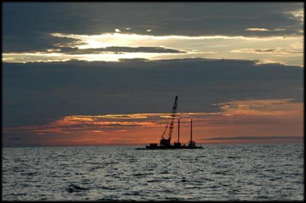
2 Hurricane Michael Landfall in Mexico Beach as a major Category 4 storm in October 2018 Maximum sustained winds 154 mph Over 10 ft storm surge Hurricane force winds (>74 mph) extended 30 miles from the eyewall Strongest hurricane on record to make landfall in the FL panhandle Photo Credit: NOAA Environmental Visualization Laboratory ( $25.1 billion in damages 1

3 Impacted Artificial Reefs Artificial reefs have been displaced in the past due to storm-force winds 650 artificial patch reefs experienced hurricane force winds 1300 artificial patch reefs experienced tropical storm force winds 2

")

4 Assessment Sites Photo Credit: MBARA Bell Shoals (15-25 ft depth) Sherman/Crooked Island Sites (60-75 ft depth) 3


5 Assessment Methods Side Scan Operations Dive Observations Compare pre- and post- storm imagery Locate displaced reefs Ground truth side scan imagery Assess damage to artificial reef material 4

6 Assessment Methods Same track pre- and post- storm Pre-storm: September 2017 Post-storm: December 2018 Three days to map Bell Shoals 28 lines that were 4 miles long Each track 290 ft apart 6.25 mi 2 area Post-processing Cleaning the imagery Identifying materials 5
7 Assessment Methods MB-196 Pre-Imagery (September 2017) Post-Imagery (December 2018) Locations of individual material manually identified in pre- and post- imagery Pyramid Modules Ecosystem (Piling) 6
 Post-Imagery (December")

8 Assessment Methods MB-196 Pre-Imagery (September 2017) Post-Imagery (December 2018) Displacement of material locations assessed in ArcGIS Pyramid Modules Ecosystem (Piling) 7

 Grouper Box w/")


9 Results Bell Shoals Post-storm Locations Pre-storm Locations Five reef types Secondary use concrete Ecosystem (Piling) Grouper Box w/ Ecosystem Reefball Pyramid XH6WXft.X4W ft. Hft.X5H6ft.ft. 7ft.DDiameter Above Seafloor: Tons Below Seafloor: 15 ft. fiberglass piling 1.5 Tons 8ft. H X 10 W 3 Tons Material deployed distinct artificial patch reefs Pre-storm: 524 individual artificial reefs Post-storm: 500 individual artificial reefs 8


10 Material Assessment Ecosystem with Piling Grouper Box with Ecosystem FWC January 2019 FWC January 2019 No damage or movement No damage or lateral movement Grouper box subsided or buried 9

11 Material Assessment Secondary Use Concrete Gordy s Reef Photo Credit: MBARA June 2010 No damage or movement Material uncovered Bell Shoals Total: Pre-storm: 1,077.5 ft 2 Post-storm: 6,205.4 ft 2 10


12 Material Assessment Reefballs Karl Sinclair Reef Photo Credit: MBARA June 2010 No damage and minimal movement More uncovered than buried Bell Shoals Total: Pre-storm: 70 Reefballs Post-storm: 83 Reefballs 11

13 Material Assessment - Pyramids Only module type displaced Minimal damage observed Majority moved outside patch reef Displaced pyramids toppled 12


14 Material Assessment - Pyramids Most pyramids identical Search for memorial reefs Memorial reef easily identified Unique plaque Embedded object: Sport memorabilia 13


")

15 Billy Gillen Memorial Reef Deployed April 7, 2015 Identified by Georgia Bulldog and plaque Measured displacement distance: 956 ft (North) Expect similar movement for other pyramids Photo Credit: MBARA 14

16 Where did the Pyramids move? 83% oriented SE-SW 15
17 Pyramid Movement Not all pyramids were displaced 35% remained in patch reef Other material impeded movement Majority of the pyramids moved Mean distance: 803 ft Max confirmed distance: 956 ft Max estimated distance: 2,887 ft (>0.5 miles) 16


18 Crooked Island & Sherman Sites Modules deployed 2016 and 2017 Depth: ft High precision deployment GPS placed upon the crane boom Allows for pre- and post- comparison 17


19 Crooked Island & Sherman Sites 5 patch reefs surveyed 65 modules pre-storm 65 modules post-storm Module Types Super Reef Pyramid FL Limestone Pyramid Grouper Box w/ Ecosystem 5 ft. H X 6 ft. W X 7 D 3.5 Tons ft. H X 19ft. 10 W 19 3 Tons Each module type: No evidence of movement No apparent damage 18

20 Conclusion- Summary Secondary Use, Reefballs, Ecosystem on Pilings and Grouper Boxes remained in same location FL Limestone Pyramids (8 ft) Only moved in shallow water (<25 ft) Has artificial reef function changed? Habitat Relief vs Footprint Different fishing and diving experience Cluster vs Spread Fish assemblage structure Forage Area vs Complexity 19
 North Site South Site Bridge Span SAARS H LAARS A Continue dive")
21 Future Monitoring Prioritize Side Scan: 1. Mid-depth Sites (50-75 ft) Car Body Tower Sites 2. Deeper Sites ( ft) North Site South Site Bridge Span SAARS H LAARS A Continue dive assessments 20

22 Bell Shoals Hurricane Assessment Viewer : 21
23 Questions
WALTON COUNTY NRDA ARTIFICIAL REEF PROGRAM
 WALTON COUNTY NRDA ARTIFICIAL REEF PROGRAM Melinda Gates Lauren Floyd Kathryn Brown Beau Suthard, PG Franky Stankiewicz Walton County - Coastal Resource Liaison APTIM - Senior Marine Biologist APTIM -
East Central Florida Region Matt Culver, Brevard County James Gray, Indian River County Jim Oppenbourn, St. Lucie County Kathy Fitzpatrick, Martin
 James Gray, Indian River County January 14, 2015 East Central Florida Region Matt Culver, Brevard County James Gray, Indian River County Jim Oppenbourn, St. Lucie County Kathy Fitzpatrick, Martin County
Florida s Artificial Reef Monitoring Efforts
 Florida s Artificial Reef Monitoring Efforts Prepared by Keith Mille March 14, 2016 Dive assessment of the Oriskany Reef, October 2006. Photo by Keith Mille Florida Fish and Wildlife Conservation Commission
Integrating basic and applied ecology using paired artificial natural reef systems.
 Integrating basic and applied ecology using paired artificial natural reef systems. Christopher D. Stallings 1, Kara R. Wall 1, Peter Simard 1, Jennifer E. Granneman 1, Kelly Kingon 2, and Christopher
Assessment of the Introduced Lionfish in Everglades and Dry Tortugas National Parks
 Assessment of the Introduced Lionfish in Everglades and Dry Tortugas National Parks Tracy A. Ziegler, Ph.D. Fisheries Biologist National Park Service Problem Sightings of lionfish at Dry Tortugas (DRTO)
ARTIFICIAL REEF CONSTRUCTION: AN ENGINEERED APPROACH. Timothy K. Blankenship, P.E. R. Harvey Sasso, P.E.
 ARTIFICIAL REEF CONSTRUCTION: AN ENGINEERED APPROACH Timothy K. Blankenship, P.E. R. Harvey Sasso, P.E. Coastal Systems International, Inc. 464 South Dixie Highway Coral Gables, Florida 33146 Stephen Higgins
STATUS REPORT FOR THE SUBMERGED REEF BALL TM ARTIFICIAL REEF SUBMERGED BREAKWATER BEACH STABILIZATION PROJECT FOR THE GRAND CAYMAN MARRIOTT HOTEL
 August 23 STATUS REPORT FOR THE SUBMERGED REEF BALL TM ARTIFICIAL REEF SUBMERGED BREAKWATER BEACH STABILIZATION PROJECT FOR THE GRAND CAYMAN MARRIOTT HOTEL performed by Lee E. Harris, Ph.D., P.E. Consulting
6/19/2006 The Reef Ball Foundation 1
 6/19/2006 The Reef Ball Foundation 1 Overview Reef Balls are prefabricated concrete modules used as a base for natural coral reefs to form. Reef Balls have been used in 55 countries in over 3,500 projects
Improving fishermen awareness to reduce the presence of lobster traps in MPAs of the Florida Keys. Gabrielle Renchen & Tom Matthews
 Improving fishermen awareness to reduce the presence of lobster traps in MPAs of the Florida Keys Spiny Lobster Advisory Panel Meeting Key Largo, FL April 25, 2016 Gabrielle Renchen & Tom Matthews Florida
Tires: unstable materials for artificial reef construction
 Environmental Problems in Coastal Regions VI 215 Tires: unstable materials for artificial reef construction R. L. Sherman & R. E. Spieler Farquhar College of Arts and Sciences and Oceanographic Center,
Artificial Reef Program. A Win for Our Ecosystem, a Win for Our Economy!
 Artificial Reef Program A Win for Our Ecosystem, a Win for Our Economy! A Boom for Economic Development Deploy 36 artificial reefs off the Coast of Naples/Marco/Collier County. Pay for the reefs with a
Biogeographic Assessment of Florida Keys National Marine Sanctuary
 Biogeographic Assessment of Florida Keys National Marine Sanctuary NOAA National Centers for Coastal Ocean Science NOAA Florida Keys National Marine Sanctuary Florida Fish and Wildlife Commission Photos
Project Webpage:
 Project Webpage: http://nature.ly/marinesatlanticbightera Coastal Data and Full Metadata: http://easterndivision.s3.amazonaws.com/marine/sab MA/SABMACoastalEcosystems.zip Coastal Chapter: http://easterndivision.s3.amazonaws.com/marine/sab
Lessons Learned from Shoreline Protection Demonstration Projects in Southwest Louisiana
 Lessons Learned from Shoreline Protection Demonstration Projects in Southwest Louisiana Tommy McGinnis and Maggie Luent CPRA Operations Division Lafayette Regional Office State of the Coast June 01, 2018
Go to Reference with Economic Statistics for US by Region and State. NOAA summary of fisheries of the US by state
 Go to Reference with Economic Statistics for US by Region and State Fisheries Economics of the United States 2014 Economics and Sociocultural Status and Trends Series U.S. Department of Commerce National
New Jersey Scuba Diver - Artificial Reefs - Townsends
 Page 1 of 7 Townsends Reef Home & Search Artificial Reefs Contents Top of Page Deepwater Reef Latest News Prev Next Dive Sites Marine Biology Artifacts & Shipwrecks Gear & Training Bay Jack Donna's Star
Determining coral reef impacts associated with boat anchoring and user activity
 Determining coral reef impacts associated with boat anchoring and user activity Protect Our Reefs Grant Interim Report October 1, 2008 March 31, 2009 Donald C. Behringer 1, Thomas K. Frazer 1, Robert A.
Effective multi-agency collaboration improves spatial monitoring and planning in the Florida Keys
 Effective multi-agency collaboration improves spatial monitoring and planning in the Florida Keys Jim Bohnsack Southeast Fisheries Science Center NOAA Fisheries Service Miami, FL 1 The Managed Florida
Eglin Air Force Base, FL
 Determining Marine Movement and Behavior of the Gulf Sturgeon in the Gulf Sturgeon Critical Habitat of the Gulf Testing and Training Range and Santa Rosa Island Complex Bob Miller/J. Mike Nunley /Amanda
Case Study 3. Case Study 3: Cebu Island, Philippines MPA Network 10
 Case studies of mpa networks Case Study 3: Cebu Island, Philippines MPA Network 10 Location and background Cebu Island in the Philippines lies in the center of the Visayan Islands, known as an area high
Evolution of Deepwater Coral Protection in the Southeast U.S
 Evolution of Deepwater Coral Protection in the Southeast U.S Tina Udouj, Florida Fish and Wildlife Conservation Commission Roger Pugliese, South Atlantic Fishery Management Council Overview Deepwater Corals
Utilizing Vessel Based Mobile LiDAR & Bathymetry Survey Techniques for Survey of Four Southern California Breakwaters
 Utilizing Vessel Based Mobile LiDAR & Bathymetry Survey Techniques for Survey of Four Southern California Breakwaters Western Dredging Association: Pacific Chapter September 2012 Insert: Pipe Location
Restoration of Spawning Habitat for Native Fish in the Central Great Lakes
 Restoration of Spawning Habitat for Native Fish in the Central Great Lakes D. H. B E N N I O N 1, E. R O S E M A N 1, B. M A N N Y 1, G. K E N N E D Y 1, J. B O A S E 2, J C R A I G 1 1 U S G S - G R E
Oceans Humans both depend on it and threaten it with their activities
 Oceans Humans both depend on it and threaten it with their activities Oceans Water covers nearly ¾ of the Earth s surface More than 50% of the world s population lives within an hour of the coast Oceans
BookletChart. Sand Key to Rebecca Shoal NOAA Chart A reduced-scale NOAA nautical chart for small boaters
 BookletChart Sand Key to Rebecca Shoal NOAA Chart 11439 A reduced-scale NOAA nautical chart for small boaters When possible, use the full-size NOAA chart for navigation. Published by the National Oceanic
UNDERSTANDING STORM SURGE
 The Education Program at the New Jersey Sea Grant Consortium 22 Magruder Road, Fort Hancock, NJ 07732 (732) 872-1300 www.njseagrant.org UNDERSTANDING STORM SURGE ACTIVITY 6 SURGE OF THE STORM http://secoora.org/classroom/virtual_hurricane/surge_of_the_storm>
Lee E. Harris, Ph.D., P.E. Assoc. Professor of Ocean Engineering. Doug Bowlus and Ashley Naimaster Ocean Engineering Graduate Students
 FLORIDA TECH OCEAN ENGINEERING PROFESSOR LEE HARRIS AND HIS GRADUATE STUDENTS ASSIST WITH POST-HURRICANE IVAN CORAL REEF RESTORATION IN THE CAYMAN ISLANDS Lee E. Harris, Ph.D., P.E. Assoc. Professor of
Climate change, Carbon Markets and wildlife management in Florida. Doug Parsons Florida Fish and Wildlife Conservation Commission April 7th, 2009
 Climate change, Carbon Markets and wildlife management in Florida Doug Parsons Florida Fish and Wildlife Conservation Commission April 7th, 2009 Florida Fish and Wildlife Conservation Commission Mission:
OYSTER REEF RESTORATION; RESTORING ECOLOGICAL FUNCTION
 OYSTER REEF RESTORATION; RESTORING ECOLOGICAL FUNCTION Paul Jensen, David Buzan, and Ka-Leung Lee; Atkins Mark Dumesnil and Julie Sullivan; The Nature Conservancy Presentation Overview The Nature Conservancy
ARTIFICIAL REEF RESEARCH OFF COASTAL ALABAMA
 ARTIFICIAL REEF RESEARCH OFF COASTAL ALABAMA ANDREW J. STRELCHECK Florida Fish and Wildlife Conservation Commission Division of Marine Fisheries INTRODUCTION Most artificial reef studies to date have focused
Artificial Reef Program Management Plan for Walton County, Florida
 Artificial Reef Program Management Plan for Walton County, Florida May 2015 Artificial Reef Program Management Plan for Walton County, Florida Prepared for By 1221 Airport Road, Suite 210 Destin, FL 32541
Unless otherwise noted, images throughout the presentation are by FWC.
 This is a review and discussion of actions and discussions from the Gulf of Mexico Fishery Management Council s (Council) Oct. 22-25 meeting in Mobile, AL. Division: Marine Fisheries Management Authors:
Florida Fish and Wildlife Conservation Commission (FWC)
") Florida Fish and Wildlife Conservation Commission (FWC) Mason Smith Florida Fish and Wildlife Conservation Commission Division of Marine Fisheries Management Version 1 FWC Mission To manage fish and wildlife
Florida Fish and Wildlife Conservation Commission (FWC) Mason Smith Florida Fish and Wildlife Conservation Commission Division of Marine Fisheries Management Version 1 FWC Mission To manage fish and wildlife
Artificial Reef Uses. Mitigation Shore Protection Scientific Studies Habitat Creation Conservation Economic Stimulus Diver Attractions
 Artificial Reef Uses Mitigation Shore Protection Scientific Studies Habitat Creation Conservation Economic Stimulus Diver Attractions Barbados Study The Relationship between Diver Experience Levels and
Re: Algae/Cyanobacteria Bloom in St. Lucie, Martin, Palm Beach and Lee Counties.
 July 18, 2016 Richard L. Scott Governor, State of Florida 400 S Monroe St Tallahassee, FL 32399 Re: Algae/Cyanobacteria Bloom in St. Lucie, Martin, Palm Beach and Lee Counties. Dear Governor Scott: I am
BookletChart. Intracoastal Waterway Matecumbe to Grassy Key NOAA Chart A reduced-scale NOAA nautical chart for small boaters
 BookletChart Intracoastal Waterway Matecumbe to Grassy Key NOAA Chart 11449 A reduced-scale NOAA nautical chart for small boaters When possible, use the full-size NOAA chart for navigation. Published by
Reef Fish Amendment 32 Gag and Red Grouper
 AMENDMENT GUIDE 11/2/11 Reef Fish Amendment 32 Gag and Red Grouper Provisions in the Magnuson-Stevens Fishery Conservation and Management Act require regional fishery management councils to develop annual
LIONFISH CONTROL PLAN
 LIONFISH CONTROL PLAN Action Items Summary 2017 LIONFISH CONTROL PLAN Action Items Summary 2017 Two species of Indo-Pacific lionfish have invaded the coastal and deep waters of the state of Florida. Lionfish
Florida Reef Fish Guide READ ONLINE
 Florida Reef Fish Guide READ ONLINE Coral Reef Basic Facts About Coral Reefs - Coral reefs cover less than 0.2% of our oceans but they contain 25% of the world's marine fish species! Coral reefs are second
MAHS Field School 2018 Pickles Reef Florida Keys National Marine Sanctuary
 MAHS Field School 2018 Pickles Reef Florida Keys National Marine Sanctuary MAHS returned to Pickles Reef in June of 2018 to hold its annual field school. Pickles Reef lies about 6 miles from Key Largo
Essential Fish Habitat. Conservation and Management
 Essential Fish Habitat Agenda Item H.8.b Supplemental Public Comment 8 September 2015 Conservation and Management Olympic Coast NMS Mariel Combs and Geoff Shester PFMC H.8 Groundfish EFH/RCA Modifications
Unless otherwise noted, images throughout the presentation are by FWC.
 This presentation provides an update on current programs in place to collect catch and effort data for Florida s saltwater recreational fisheries, including the Gulf Reef Fish Survey (GRFS) and potential
The State of Florida Artificial Reef Program s Dive Assessment Team: 22 Years of Fish Census Data, 1992 to 2014
 The State of Florida Artificial Reef Program s Dive Assessment Team: 22 Years of Fish Census Data, 1992 to 2014 Bill Horn Florida Fish and Wildlife Conservation Commission (retired) Division of Marine
Florida Seagrass Integrated Mapping and Monitoring Program
 Florida Seagrass Integrated Mapping and Monitoring Program - 2004 The following document is composed of excerpts taken from the 2011 publication, Seagrass Integrated Mapping and Monitoring for the State
Bonaire National Marine Park Hurricane Matthew Reef Damage Assessment
 Bonaire National Marine Park Hurricane Matthew Reef Damage Assessment Hurricane Matthew passed north of Bonaire on September 23 rd, 2016. After it passed Aruba, it decelerated, and then it slowly began
Vieques Underwater Demonstration Project
 Vieques Underwater Demonstration Project NOAA Office of Response and Restoration National Ocean Service 2006-2007 2007 University of New Hampshire Joint Hydrographic Center 2006 Science Application International
Authors: Luiz Barbieri and Martha Bademan
 This is a review and discussion of a proposal to develop and implement a Gulf Offshore Recreational Fishing Permit in support of more accurate, precise, and timely catch and effort estimates for offshore
Field Protocol for Monitoring Coral Reef Fisheries Resources in Belize
 Field Protocol for Monitoring Coral Reef Fisheries Resources in Belize Charles A. Acosta, PhD Wildlife Conservation Society Glover s Reef Marine Research Station P.O. Box 272 Dangriga, Belize and Department
Southeast Volusia Coastal Projects Update
 Southeast Volusia Coastal Projects Update Public Works Department Coastal Division August 15, 2016 2016 Dune Walkover Re-Decking Program Completed Dune Walkovers South End 8 th Ave. New Smyrna Beach* 12
Assessment of Creosote-Treated Structures and Other Artificial Substrates in San Francisco Bay
 Assessment of Creosote-Treated Structures and Other Artificial Substrates in San Francisco Bay Jennifer Hunt, Christine Werme, Kristen Cayce, Marcus Klatt, William Winner, Erin Beller, Eric Polson, Robin
Unit 1 Lesson 2: Reef Surveys and Deep Worker. When Coral Reefs Get in the Way...
 Unit 1 Lesson 2: Reef Surveys and Deep Worker Lesson Objectives: Upon completion of this unit students should gain knowledge and understanding of: factors that cause physical damage to coral reefs the
Georgia s Offshore Artificial Reef Project Historical Summary
 Georgia s Offshore Artificial Reef Project Historical Summary The Georgia Department of Natural Resources (GADNR) Offshore Artificial Reef (OAR) Project was established to develop long-term fisheries habitat
Final Report, October 19, Socioeconomic characteristics of reef users
 Socioeconomic Study of Reefs in Southeast Florida - Executive Summary By Hazen and Sawyer in association with Florida State University and National Oceanic and Atmospheric Administration, October 19, 2001
Geomorphology of grouper and snapper spawning aggregation sites in the Upper Florida Keys, USA
 Geomorphology of grouper and snapper spawning aggregation sites in the Upper Florida Keys, USA Art Gleason, Pamela Reid Division of Marine Geology and Geophysics University of Miami / Rosenstiel School
$ Course Price Includes: all materials, dive gear, instruction and 1 boat dive.
 Discover Scuba Diving: $140.00 If you ve never tried scuba diving or you ve tried but you are still not sure you re ready to pursue certification, this is the course for you. Often referred to as a resort
Miccosukee Tribe of Indians of Florida. Rory Feeney: Fish and Wildlife Director Gintautas Zavadzkas: Fisheries Biologist
 Miccosukee Tribe of Indians of Florida Rory Feeney: Fish and Wildlife Director Gintautas Zavadzkas: Fisheries Biologist History/Background Priority Animal Species Priority Animals Burmese Python, exotic
Hook Selectivity in Gulf of Mexico Gray Triggerfish when using circle or J Hooks
 Hook Selectivity in Gulf of Mexico Gray Triggerfish when using circle or J Hooks Alisha M. Gray and Beverly Sauls SEDAR43- WP- 09 25 March 2015 This information is distributed solely for the purpose of
South Atlantic proposed MPAs: : three years of pre- closure data on habitat and fish assemblages
 South Atlantic proposed MPAs: : three years of pre- closure data on habitat and fish assemblages Principal Investigators: Stacey L. Harter Andrew W. David NOAA Fisheries, Panama City, FL Similar project
Artificial Reefs of the Gulf of Mexico:
 Artificial Reefs of the Gulf of Mexico: A Review of Gulf State Programs & Key Considerations November 2013 Reef Pyramids being deployed into a Florida Bay Photo Courtesy of Florida Fish & Wildlife Conservation
Sheepshead Fishery Overview South Atlantic State/Federal Management Board May 2014 Introduction Life History Landings
 Sheepshead Fishery Overview South Atlantic State/Federal Management Board May 2014 Introduction The Atlantic States Marine Fisheries Commission (ASMFC) does not currently manage sheepshead (Archosargus
Small Footprint Topo-Bathymetric LiDAR
 May 8, 2013 Small Footprint Topo-Bathymetric LiDAR PNAMP Remote Sensing Forum Russ Faux, Co-CEO, WSI Amar Nayegandhi, Manager of Elevation Technologies, Dewberry Colin Cooper, Senior Analyst, WSI Watershed
Conservation and Restoration Florida s Coastal Marshes: An Overview of MESS. Jeff Beal, Kent Smith, Erin McDevitt, Maria Merrill
 Conservation and Restoration Florida s Coastal Marshes: An Overview of MESS Jeff Beal, Kent Smith, Erin McDevitt, Maria Merrill FWC s MESS: -Marine/Estuarine Subsection -within Aquatic Habitat Conservation
A non-equilibrium surplus production model of black grouper (Mycteroperca bonaci) in southeast United States waters
 in southeast United States waters") SEDAR19-AW-05 A non-equilibrium surplus production model of black grouper (Mycteroperca bonaci) in southeast United States waters Introduction Robert G. Muller Florida Fish and Wildlife Conservation Commission
SEDAR19-AW-05 A non-equilibrium surplus production model of black grouper (Mycteroperca bonaci) in southeast United States waters Introduction Robert G. Muller Florida Fish and Wildlife Conservation Commission
Marine Recreational and Commercial Industries and Activities in Lee and Charlotte Counties: Economic Consequences and Impacts
 Marine Recreational and Commercial Industries and Activities in Lee and Charlotte Counties: Economic Consequences and Impacts Betty Staugler Florida Sea Grant Extension Marine Agent & Chuck Adams Florida
Gulf of Mexico Region Fisheries Extension Enhancement Review
 Gulf of Mexico Region Fisheries Extension Enhancement Review Rex H. Caffey Louisiana Sea Grant College Program Center for Natural Resource Economics & Policy FEE in the Gulf of Mexico Region 1) Programming
Fine-scale Focal DTAG Behavioral Study in the Gulf of Maine
 DISTRIBUTION STATEMENT A: Approved for public release; distribution is unlimited. Fine-scale Focal DTAG Behavioral Study in the Gulf of Maine Alessandro Bocconcelli Woods Hole Oceanographic Institution
Artificial Reef Program Biological Monitoring Update
 Artificial Reef Program Biological Monitoring Update Texas Parks and Wildlife Department Coastal Fisheries - Artificial Reef Program Brooke Shipley, Ph.D. Artificial Reef Program Over 4800 Acres 76 Established
Moving beyond BACI: What do to when science and reality clash in marine reserve monitoring? Workshop Held: June 10 th, 2015
 Moving beyond BACI: What do to when science and reality clash in marine reserve monitoring? Workshop Held: June 10 th, 2015 Challenges have arisen when implementing a BACI (Before-After-Control-Impact)
New two-lane bridge to replace the existing structure spanning the Maple River just south of the Village s central business district
 New two-lane bridge to replace the existing structure spanning the Maple River just south of the Village s central business district Rehabilitate the old bridge Convert to a nonmotorized trail Restore
What is Project Baseline?
 What is Project Baseline? A global network of highly skilled and organized SCUBA divers who are creating a lasting visual legacy of underwater conditions in oceans, lakes, rivers, springs, and caves all
While the fishing standing stock at Wheeler North Reef has been consistently below the 28 ton requirement, data from last summer s survey showed that
 1 While the fishing standing stock at Wheeler North Reef has been consistently below the 28 ton requirement, data from last summer s survey showed that it increased by 88% in 2014. This raises the question
WELCOME. FM 2818 (Harvey Mitchell Parkway) Open House. Tuesday, Nov. 14, 2017
 Open House. Tuesday, Nov. 14, 2017") WELCOME FM 2818 (Harvey Mitchell Parkway) Open House Tuesday, Nov. 14, 2017 Why am I here? Review the planned improvements Provide comments on the proposed project The environmental review, consultation,
WELCOME FM 2818 (Harvey Mitchell Parkway) Open House Tuesday, Nov. 14, 2017 Why am I here? Review the planned improvements Provide comments on the proposed project The environmental review, consultation,
The Maho Beach Resort and Casino. By The. Submitted to. With Contributions From. ?? Lee E. Harris, Ph.D., P.E. Consulting Coastal/Ocean/Engineer
 Proposal for Reef Ball Artificial Reef Submerged Breakwater to Assist with Shoreline Stabilization for the Maho Beach Resort with Optional Snorkeling/Diving Trails and Coral Propagation For Maho Beach
Climate Change Impacts to KSC Launch Complex
 Climate Change Impacts to KSC Launch Complex Presented to: 2010 International Workshop on Environment and Energy By: John Shaffer NASA Environmental Management Branch Kennedy Space Center Hurricane Season
Fisheries of the Caribbean, Gulf of Mexico, and South Atlantic; Reef Fish Fishery of Puerto Rico and the U.S. Virgin Islands;
 This document is scheduled to be published in the Federal Register on 06/11/2018 and available online at https://federalregister.gov/d/2018-12420, and on FDsys.gov BILLING CODE: 3510-22-P DEPARTMENT OF
Zooplankton community structure in the northern Gulf of Mexico: Implications for ecosystem management
 Zooplankton community structure in the northern Gulf of Mexico: Implications for ecosystem management By Andrew F. Millett Dauphin Island Sea Lab University of South Alabama W. Monty Graham, Glenn A. Zapfe,
Ivan-like hurricane storm surge simulations for Tampa Bay, FL with 3-D and 2-D models
 Ivan-like hurricane storm surge simulations for Tampa Bay, FL with 3-D and 2-D models R.H. Weisberg and L. Zheng Storm Surge Workshop St. Pete Beach 2/11/09 Potential for Tampa Bay area inundation is large
Introduction to Storm Surge
 Introduction to Storm Surge Hurricane Katrina (2005) Mississippi 1200 deaths, $108 billion damage Hurricane Sandy (2012) Northeast U.S. 73 deaths, $65 billion damage Hurricane Ike (2008) - Bolivar Peninsula,
SARASOTA BAY ESTUARY PROGRAM OYSTER HABITAT MONITORING RESULTS: YEAR 1. Jay R. Leverone
 SARASOTA BAY ESTUARY PROGRAM OYSTER HABITAT MONITORING RESULTS: YEAR 1 by Jay R. Leverone Mote Marine Laboratory 1600 Ken Thompson Parkway Sarasota, Fl 34236 to Gary Raulerson Sarasota Bay Estuary Program
Abaco Islands, Bahamas 2015 Deployments
 On May 13, 2015, the IGFA Great Race (IGMR) returned to Abaco Beach Resort & Marina in the Bahamas for the 2015 Custom Shootout where fifty-two custom built sport-fishing yachts entered the 14th annual
PENSACOLA BAY BRIDGE PROJECT DEVELOPMENT AND ENVIRONMENT (PD&E) STUDY. Appendix D to the Environmental Assessment Standard Protection Measures
 STUDY. Appendix D to the Environmental Assessment Standard Protection Measures") February 2015 PENSACOLA BAY BRIDGE PROJECT DEVELOPMENT AND ENVIRONMENT (PD&E) STUDY Appendix D to the Environmental Assessment Standard Protection Measures Construction Special Provisions, Gulf Sturgeon
February 2015 PENSACOLA BAY BRIDGE PROJECT DEVELOPMENT AND ENVIRONMENT (PD&E) STUDY Appendix D to the Environmental Assessment Standard Protection Measures Construction Special Provisions, Gulf Sturgeon
LAKE JESUP VEGETATION MAPPING: AN INTER-AGENCY COLLABORATION. Lakshmi Sankaran, GISP Public Works Department, Seminole County
 LAKE JESUP VEGETATION MAPPING: AN INTER-AGENCY COLLABORATION Lakshmi Sankaran, GISP Public Works Department, Seminole County LAKE JESUP Area - 12 sq miles Shoreline - 53 miles Watershed - 136 sq miles
SECTION II NM 26/10 NAVIGATION PUBLICATIONS ALMANACS CORRECTIONS
 NAVIGATION PUBLICATIONS ALMANACS CORRECTIONS NAUTICAL ALMANAC Ed 2011 NEW EDITION (NGA) 26/10 SAILING DIRECTIONS CORRECTIONS PUB 140 8 Ed 2010 NEW EDITION (NGA) 26/10 COAST PILOT CORRECTIONS COAST PILOT
HURRICANE EARL FINAL DAMAGE ASSESSMENT REPORT FOR ANTIGUA AND BARBUDA S FISHERIES SECTOR
 HURRICANE EARL FINAL DAMAGE ASSESSMENT REPORT FOR ANTIGUA AND BARBUDA S FISHERIES SECTOR Photo: Mark Archibald Danielle Earl NOAA Sun Aug 29, 2010, 5:50pm Fisheries Division Ministry of Agriculture, Lands,
Mitigation Plan for Broward County Beach Erosion Control Project Broward County, Florida
 Mitigation Plan for Broward County Beach Erosion Control Project Broward County, Florida United States Army Corps of Engineers Permit # 199905545 (IP-DSG) Florida Department of Environmental Protection
In-Water Mass Spectrometry for Characterization of Light Hydrocarbon Seeps and Leaks
 In-Water Mass Spectrometry for Characterization of Light Hydrocarbon Seeps and Leaks R. T. Short, S. K. Toler, A. M. Cardenas-Valencia, S. Untiedt, C. Cullins, M. Ryder, and J. Kloske HEMS Workshop 2015
Fishing Panama City. and Surrounding Areas. halfhitch.com. Presented by Ron Barwick Service Manager at Half Hitch
 Fishing Panama City and Surrounding Areas Presented by Ron Barwick ron@halfhitch.com Service Manager at Half Hitch halfhitch.com 1 Inshore Fishing Inshore Panama City Fishing Forecast May 2012 Speckled
Protect Our Reefs Grant Interim Report (October 1, 2008 March 31, 2009) Principal investigators: Donald C. Behringer and Mark J.
 Principal investigators: Donald C. Behringer and Mark J.") Investigating the role of the spotted spiny lobster (Panulirus guttatus) in the recovery of the long spined sea urchin (Diadema antillarum) on the coral reefs of the Florida Keys Protect Our Reefs Grant
Investigating the role of the spotted spiny lobster (Panulirus guttatus) in the recovery of the long spined sea urchin (Diadema antillarum) on the coral reefs of the Florida Keys Protect Our Reefs Grant
Black Seabass Length Frequencies and Condition of Released Fish from At-Sea Headboat Observer Surveys, 2004 to 2010.
 SEDAR25-DW1 Black Seabass Length Frequencies and Condition of Released Fish from At-Sea Headboat Observer Surveys, 24 to 21. Prepared by: Beverly Sauls, Florida Fish and Wildlife Conservation Commission
Presentation to : Marine Aquaculture Task Force 2006
 Presentation to : Marine Aquaculture Task Force 2006 January 19th, 2006 Kona Kampachi Development of the first hatch-to-harvest open ocean fish farm in the U.S. Presentation by: Neil Anthony Sims, M.Sc.
NASA takes 23,000-foot view of the world's coral reefs 9 June 2016, by Caleb Jones
 NASA takes 23,000-foot view of the world's coral reefs 9 June 2016, by Caleb Jones Using specially designed instruments mounted on high-flying aircraft, the scientists plan to map large understanding how
Goliath Grouper Public Workshops August and October, 2017
 Goliath Grouper Public Workshops August and October, 2017 Florida Fish and Wildlife Conservation Commission Division of Marine Fisheries Management and Fish and Wildlife Research Institute Version 1 1
VII. Marine debris distribution
 2008 Quick Look Report: Miller et al. VII. Marine debris distribution Background Fishing constitutes one of the most significant threats to marine biodiversity and ecosystem function, documented by a growing
Behavior and survival of hatchery reared advanced fingerling largemouth bass using radio telemetry. Brandon Thompson
 Behavior and survival of hatchery reared advanced fingerling largemouth bass using radio telemetry Brandon Thompson Florida largemouth bass Micropterus salmoides floridanus Premier freshwater sportfish
OFFSHORE PATROL VESSEL OPERATIONS
 Florida Fish and Wildlife Conservation Commission Division of Law Enforcement OFFSHORE PTROL VESSEL OPERTIONS GENERL ORDER EFFECTIVE DTE RESCINDS/MENDS PPLICBILITY 30 May 7, 2018 July 21, 2008 ll Sworn
Geographic Response Plan Map: SFL-21. Map continued on: SFL-31S XXX. k Curry Hammock. SFL21-05 Grassy Key Beaches. Map continued on: SFL-20
 ! 81 0'0"W Geographic Response Plan Map: SFL-21 Map continued on: SFL-31S 80 52'30"W Arse XXX S A 24 52'30"N j Everglades National Park [] [ 24 52'30"N Florida Bay Flo Nati S 9N-01 oo Banks ock 54! Bamboo
Volume and Shoreline Changes along Pinellas County Beaches during Tropical Storm Debby
 Volume and Shoreline Changes along Pinellas County Beaches during Tropical Storm Debby Ping Wang and Tiffany M. Roberts Coastal Research Laboratory University of South Florida July 24, 2012 Introduction
Florida panther conservation challenges. Darrell Land, Florida Fish and Wildlife Conservation Commission
 Florida panther conservation challenges Darrell Land, Florida Fish and Wildlife Conservation Commission Map from Young and Goldman 1946 depicting Puma distribution in North and Central America Former and
Point LaBarbe/McGulpin Point Response April 2 May 8, 2018 Regional Response Team 3 Meeting November, 2018
 Point LaBarbe/McGulpin Point Response April 2 May 8, 2018 Regional Response Team 3 Meeting November, 2018 TJ Mangoni District Response Advisory Team Supervisor Ninth Coast Guard District 216-214-4285 Summary
A PHYSICAL AND BIOLOGICAL SURVEY OF THE MID-REACH MITIGATION REEF SET NUMBER 1
 A PHYSICAL AND BIOLOGICAL SURVEY OF THE MID-REACH MITIGATION REEF SET NUMBER 1 John M. Hearin, Ph.D., P.E. 1 ; Geoff Swain, Ph.D. 2 ; Robert Weaver, Ph.D., P.E. 2 ; Kelli Z. Hunsucker, Ph.D. 2 ; Caglar