APPENDIX F BIGHT 13 FIELD SAMPLING DATA SHEETS
|
|
|
- Roderick McLaughlin
- 5 years ago
- Views:
Transcription
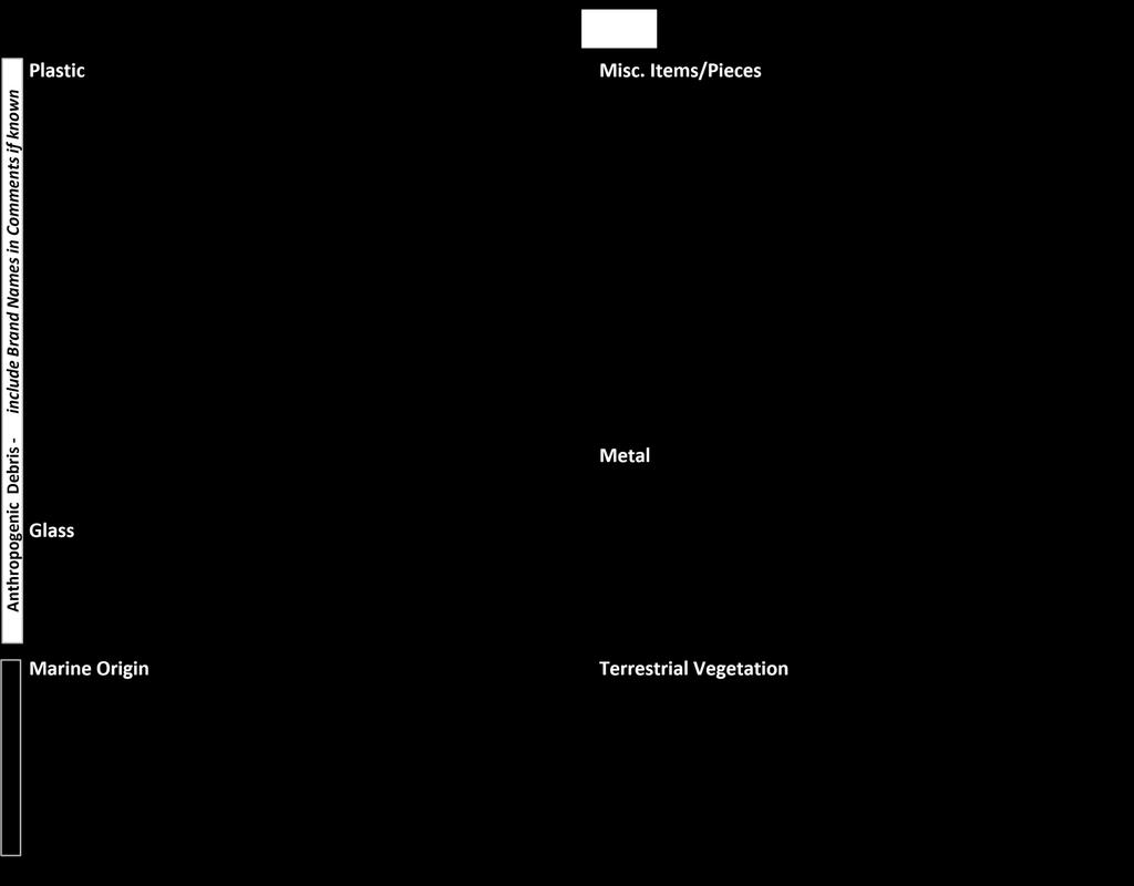
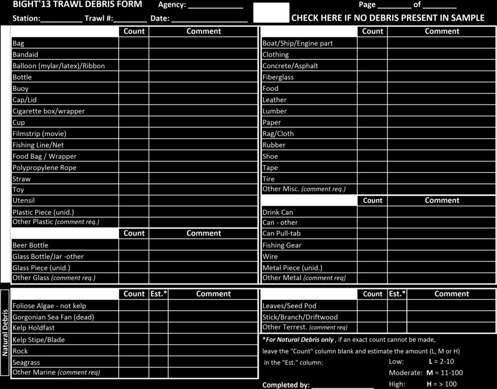
1 APPENDIX F BIGHT 13 FIELD SAMPLING DATA SHEETS
2 STATION OCCUPATION BIGHT 13 Agency Code Weather Sea State Salinity (ppt) Station ID Clear Rain Calm Vessel Name Overcast Thunderstorm Choppy At estuary Sites only Date Arrival Time (hh:mm) Partly cloudy Fog Rough Drizzle Abandoned site? Y or N (If Y explain in comments) Wind Swell Nav Type Station Comments Speed (kts) Period (s) DGPS Direction (4) Height (ft) GPS Station Fail Code Direction (4) Equipment Type Van Veen Tandem Van Veen GRAB EVENTS Sample types (Chk all that apply) # Time (hh:mm) Latitude (DD MM.mmmm) Longitude (DD MM.mmmm) Depth (m) Distance to target (m) Grab Fail Code (6) Penetration (cm) Composition (1) Odor (2) Color (3) Shell Hash (Y/N) Infauna Sed Chem Grain Size Sed Tox Debris (Y/N) Grab Event Comments: Grab Event Comments: Grab Event Comments: Grab Event Comments: Grab Event Comments: Grab Event Comments: 1 Sediment Composition: Coarse sand, Fine sand, Silt/clay, Gravel, Cobble, Mixed 2 Sediment Odor: None (N), Petroleum (P), Hydrogen sulfide (HS), Humic (HU), Other (O, describe in comments) 3 Sediment Color: Brown, Gray, Black, Olive green, Red 4 Directions: N, NE, E, SE, S, SW, W, NW, or XX for calm 5 Station Fail codes: None, Temporary - sea conditions (comment req.), Temporary - atmosphere (comment req.), Temporary - mechanical (comment req.), Pre-abandoned (comment req.), Site On Land (comment req.), Vessel safety (comment req.), No Access Allowed (comment req.), Prolonged rough seas, Bottom salinity <25psu, Too Shallow (comment req.), Too many Event Failures (comment req.), Anthropogenic obstruction (comment req.), Natural hard bottom obstructions (comment req.), Not sampleable - other (comment req.) Grab Fail codes: None, Outside Radius Limit, Outside Target Depth, Premature closure, Flipped, Rocks/gravel, Dead shell, Live animal (comment req.), Debris (comment req.), Poor closure - other (comment req.), Heavily Canted, Large Humping, Washed, Disturbed Surface, < 5 cm Penetration, <= 7 cm Penetration - biology only
3 STATION OCCUPATION BIGHT 13 Agency Code Weather Sea State Nav Type Station ID Clear Rain Calm DGPS Vessel Name Overcast Thunderstorm Choppy GPS Date Partly cloudy Fog Rough Arrival Time Drizzle (hh:mm) Abandoned site? Station Fail Code Y or N (If Y explain in comments) Wind Swell Station Comments Speed (kts) Direction (4) Period (s) Height (ft) Direction (4) TRAWL EVENTS Trawl Number Time (hh:mm) Latitude (DD MM.mmmm) Longitude (DD MM.mmmm) Depth (m) Wire Out Distance to target (m) Trawl Fail Code (3) P/T Sensor Data (Y/N) Community Structure (Y/N) Tissue Chemistry (Y/N) Net Over Start Trawl End Trawl Net on Deck Net Over Start Trawl End Trawl Net on Deck Net Over Start Trawl End Trawl Net on Deck 1 Directions: N, NE, E, SE, S, SW, W, NW, or XX for calm 2 Station Fail codes: None, Temporary - sea conditions (comment req.), Temporary - atmosphere (comment req.), Temporary - mechanical (comment req.), Pre-abandoned (comment req.), Site On Land (comment req.), Vessel safety (comment req.), No Access Allowed (comment req.), Prolonged rough seas, Bottom salinity <25psu, Too Shallow (comment req.), Too many Event Failures (comment req.), Anthropogenic obstruction (comment req.), Natural hard bottom obstructions (comment req.), Not sampleable - other (comment req.) 3 Trawl Fail codes: None, Outside Radius Limit, Outside Target Depth, Fouled Net (comment req.), Open cod end (knot untied), Trawl hit unknown obstruction, Doors - No contact with bottom, Torn Net, Unusually low catch, Improper Deck Time, Improper Bottom Time, Inadequate trawl track, Other - Trawl Failure (comment req.)
4 BIGHT 13 DEMERSAL FISH IDENTIFICATION FORM Station: Page of Completed by: Data from Short/Long >300 m Depth Yes No Species N Std Length Size Class (cm) Use for up to 10 individuals. Use Size Class sheet for more abundant spp. FID or Voucher # Weight (kg) Gross Tare Net Anomaly Codes: (record as superscript to tally mark): A = ambicoloration B = albinism, D = skeletal deformity, E = copepod eye-parasite (i.e., Phrixocephalus), F = fin erosion, H = Leeches, L = lesion (describe in Comments), M = Monogeneans, O = other anomaly (describe in Comments), P = other external parasite (describe in Comments), T = tumor, multiple occurrences on individual put - and #, FID = specimen(s) collected for further identification, #V = Number of specimens collected as species vouchers Comments: QA Pass/Fail: (circle) Yes No NA (not available)
5 BIGHT 13 DEMERSAL FISH SIZE CLASS FORM Station: Page of Completed by: Gross weight (kg) Tare Weight (kg) Net weight (kg) Size class N Species: Anomalies Anomaly Codes (record as superscript to length measurement): A = ambicoloration, B = albinism, D = skeletal deformity, E = copepod eye-parasite (i.e., Phrixocephalus), F = fin erosion, H = Leeches, L = lesion (describe in Comments), M = Monogeneans, O = other anomaly (describe in Comments), P = other external parasite (describe in Comments), T = tumor, multiple occurrences on individual put - and # Comments: Total Abundance QA Pass/Fail: (circle) Yes No NA (not available)
6 Species: ALIQUOT DATA N Gross (kg) Tare (kg) Net (kg) Record Catch gross weights here: Show calculations here Catch gross wt. Catch tare wt. = catch Net wt. - = (Catch Net wt. /Aliquot net wt.) x # in Aliquot = Abundance x = All weights are to be recorded in kg. Comments:
7 BIGHT 13 EPIBENTHIC INVERTEBRATE FORM Station: Page of Completed by: Data from Short/Long >300 m Depth Yes No Species N Comments (or Anomalies) FID or Voucher # Weight (kg) Gross Tare Net Anomaly Codes: B = burnspot, P = External Parasite, O = other anomaly (describe in Comments), W = wasting disease, multiple occurrences on individual put - and #, FID = specimen(s) collected for further identification, #V = Number of specimens collected as species vouchers Comments: QA Pass/Fail: (circle) Yes No NA (not available)
8 Species: ALIQUOT DATA N Gross (kg) Tare (kg) Net (kg) Record Catch gross weights here: Show calculations here Catch gross wt. Catch tare wt. = catch Net wt. - = (Catch Net wt. /Aliquot net wt.) x # in Aliquot = Abundance x = All weights are to be recorded in kg. Species: ALIQUOT DATA N Gross (kg) Tare (kg) Net (kg) Record Catch gross weights here: Show calculations here Catch gross wt. Catch tare wt. = catch Net wt. - = (Catch Net wt. /Aliquot net wt.) x # in Aliquot = Abundance x = All weights are to be recorded in kg. Species: ALIQUOT DATA N Gross (kg) Tare (kg) Net (kg) Record Catch gross weights here: Show calculations here Catch gross wt. Catch tare wt. = catch Net wt. - = (Catch Net wt. /Aliquot net wt.) x # in Aliquot = Abundance x = All weights are to be recorded in kg.
9
10 BIGHT'13 SAMPLE TRACKING FORM AGENCY: Page of DATE: COMPLETED BY: Station Sample Description Sample disposition Include all stations that have been abandoned during the sampling day(s) and describe the reason for each instance of abandonment.
11 BIGHT 13 CHAIN OF CUSTODY FORM Agency: Contact name: Contact #: Sampled By: Station Sample type Container type # of Containers Relinquished by: Agency: Signature: Comments: Accepted by: Agency: Signature: Relinquished by: Agency: Signature: Comments: Accepted by: Agency: Signature:
12 Example: LACSD -agency name can be preprinted Station Name 4003 Gear/Split vanveen 3 of 3 Date of Collection: 21 Aug 2013
13 Example: LACSD, D. Cadien, 1Aug2013 Exosphaeroma inornata
1. Weigh entire catch (small, ~400 kg,) before or
 before or") Trawl Total Catch Estimation & Effort ISERT ISTRUCTOR ame http://wwwsafmcnet Sampling Priorities 1 Collect information on fishing effort 2 Randomly sample for catch composition 3 Record gear characteristics
Trawl Total Catch Estimation & Effort ISERT ISTRUCTOR ame http://wwwsafmcnet Sampling Priorities 1 Collect information on fishing effort 2 Randomly sample for catch composition 3 Record gear characteristics
Our Council s Own: Oceanography Cadette/Senior/Ambassador Badge
 Our Council s Own: Oceanography Cadette/Senior/Ambassador Badge Oceanography: The science that deals with oceans, the delimitation of their extent and depth, the physics and chemistry of their water, marine
SURVEILLANCE FOR AMPHIBIAN MASS MORTALITIES IN BRITISH COLUMBIA (SAMM B.C.)
") SURVEILLANCE FOR AMPHIBIAN MASS MORTALITIES IN BRITISH COLUMBIA (SAMM B.C.) In British Columbia, 64% of the frog species and 30% of the salamander species are listed as species of conservation concern.
SURVEILLANCE FOR AMPHIBIAN MASS MORTALITIES IN BRITISH COLUMBIA (SAMM B.C.) In British Columbia, 64% of the frog species and 30% of the salamander species are listed as species of conservation concern.
Protocol 1. Site Conditions Data Sheet
 Protocol 1. Site Conditions Data Sheet Field monitoring Initial Observations Name of site or water body: Coordinates: Date of monitoring: Time of monitoring: Name of monitor(s): (names of all group members)
APPENDIX F GROUNDWATER SAMPLING LOGS
 APPENDIX F GROUNDWATER SAMPLING LOGS Project:Enclave on 241 St Site Location: Bronx Well No: MW07 Date: 10/6/2015 Initial Depth to Water (ft): 15.13 Well Depth (ft): 20.00 Pump Intake Depth (ft): 19 1225
N NE E SE S SW W NW N/A. onshore offshore sideshore side-on side-off
 COASTAL SITE SURVEY Survey Guidelines: Complete one Coastal Litter survey form per site and one transect data form for each transect at the site. Record all coordinates in WGS84 datum only. Minimum of
REGIONAL AND LOCAL VARIATION OF BOTTOM FISH AND INVERTEBRATE POPULATIONS
 M. James Allen and Robert Voglin REGIONAL AND LOCAL VARIATION OF BOTTOM FISH AND INVERTEBRATE POPULATIONS One of the projects included in our recently completed research for the EPA was an assessment of
This in an internal Commission document provided to Industry for reference purposes only.
 FORM C EMERGENCY INCIDENT FORM BC Oil and Gas Commission 6534 Airport Road Fort St. John BC V1J 4M6 Phone: (250) 794-5200 emp@bcogc.ca This in an internal Commission document provided to Industry for reference
INCIDENT REPORT OASIS SAILING CLUB
 1) BOAT DESCRIPTION INCIDENT REPORT OASIS SAILING CLUB Name: Make: CATALINA Length: 34' 6" Registration: Model: CATALINA 34 MKII Type: SLOOP Hull ID: Year Built: Motor: 30 hp Diesel 2) BOAT OWNER Friends
WIND DATA REPORT. Vinalhaven
 WIND DATA REPORT Vinalhaven January - December, 2003 Prepared for Fox Islands Electric Cooperative by Anthony L. Rogers May 12, 2004 Report template version 1.1 Renewable Energy Research Laboratory 160
HOW BENTHIC HABITATS AND BOTTOM TRAWLING AFFECT TRAIT COMPOSITION IN THE DIET OF EUROPEAN PLAICE (PLEURONECTES PLATESSA) IN THE NORTH SEA
 IN THE NORTH SEA") HOW BENTHIC HABITATS AND BOTTOM TRAWLING AFFECT TRAIT COMPOSITION IN THE DIET OF EUROPEAN PLAICE (PLEURONECTES PLATESSA) IN THE NORTH SEA Jacqueline Eggleton, Kenny A.J., Bolam S.G., Depestele J., Garcia
HOW BENTHIC HABITATS AND BOTTOM TRAWLING AFFECT TRAIT COMPOSITION IN THE DIET OF EUROPEAN PLAICE (PLEURONECTES PLATESSA) IN THE NORTH SEA Jacqueline Eggleton, Kenny A.J., Bolam S.G., Depestele J., Garcia
I. Monitoring and Adaptive Management Approach. Potential Effects, Monitoring Studies & Mitigation
 I. Monitoring and Adaptive Management Approach Define the problem or management objective. Determine potential effects of the project on indicator species. Emphasis on examining potentially negative, rather
Test of new underwater television towed cone and new television sled off Redondo Beach, STRAIGHT ARROW II, 8 July 1975.
 Appendix D SAMPLING AT SEA During the past year. Project personnel conducted or participated in 109 cruises involving a total of 283 man-days at sea. The cruises are described below. Retrieval and installation
How to do the survey. Photos Indigo Pacific
 How to do the survey Photos Indigo Pacific Karakia Ko Rangi Ko Papa Ka Puta ko Rongo Ko Tanemahuta Ko Tāwhirimātea Ko Tangaroa Ko Haumietiketike Ko Tumatauenga Ko te Rangi ki runga Ko te Papa ki raro Ka
VESSEL INCIDENT REPORT (Reporting procedures required by NSW Marine Legislation)
") VESSEL INCIDENT REPORT (Reporting procedures required by NSW Marine Legislation) To assist in completing this form, please refer to the Explanatory Notes at the end of this document. For further information
VESSEL INCIDENT REPORT (Reporting procedures required by NSW Marine Legislation) To assist in completing this form, please refer to the Explanatory Notes at the end of this document. For further information
Fleming County High School Flemingsburg, KY 41041
 Fleming County High School Flemingsburg, KY 41041 Date Mon 08/15/2016 Job # Prepared By Clay Barton 6:00 AM:70 F Drizzle Wind: 1 MPH NE Precipitation:.01'' Humidity: 95% Weather 12:00 PM:81 F Light Rain
VESSEL REGISTRATION # P.O. BOX Rev. 09/10 BATON ROUGE, LA OPERATOR BOATING INCIDENT REPORT PAGE 1 of
 LOUISIANA DEPARTMENT OF WILDLIFE AND FISHERIES LAW ENFORCEMENT DIVISION DWF-BIR-010-OP VESSEL REGISTRATION # P.O. BOX 98000 Rev. 09/10 BATON ROUGE, LA 70898-9000 OPERATOR BOATING INCIDENT REPORT PAGE 1
Fine-Scale Survey of Right and Humpback Whale Prey Abundance and Distribution
 DISTRIBUTION STATEMENT A. Approved for public release; distribution is unlimited. Fine-Scale Survey of Right and Humpback Whale Prey Abundance and Distribution Joseph D. Warren School of Marine and Atmospheric
Report on Vessel Casualty of Accident (Form Casualty) Instructions:
 Instructions:") Report on Vessel Casualty of Accident (Form Casualty) Tuvalu Ship Registry 10 Anson Road #25-16 International Plaza Singapore 079903 Tel: (65) 6224 2345 Fax: (65) 6227 2345 Email: info@tvship.com Website:
Report on Vessel Casualty of Accident (Form Casualty) Tuvalu Ship Registry 10 Anson Road #25-16 International Plaza Singapore 079903 Tel: (65) 6224 2345 Fax: (65) 6227 2345 Email: info@tvship.com Website:
Trials of a Net Grid for the UK Nephrops trawl fisheries
 Trials of a Net Grid for the UK Nephrops trawl fisheries Tom Catchpole, Frank Armstrong, Stuart Masson, Dave Price, Mark O Brien & John Hingley June 2012 This work was funded by Defra Executive Summary
Essential Fish Habitat Description Atlantic herring (Clupea harengus)
") Description Atlantic herring (Clupea harengus) In its Report to Congress: Status of the Fisheries of the United States (September 1997), NMFS determined Atlantic herring is not currently overfished. This
Description Atlantic herring (Clupea harengus) In its Report to Congress: Status of the Fisheries of the United States (September 1997), NMFS determined Atlantic herring is not currently overfished. This
ESA, Proposed Threatened ESA, Threatened New Mexico-WCA, Endangered
 Scientific Name: Luciana parva Common Name: Rainwater killifish BISON No.: 010265 Legal Status: Arizona, Species of Special Concern ESA, Endangered ESA, Proposed Endangered ESA, Proposed Threatened ESA,
National Oil Spill Contingency Plan. Chapter 2 Forms
 National Oil Spill Contingency Plan Chapter 2 Forms Contents Overview... 3 Summary of Forms... 3 Pollution Incident Evaluation Form... 3 Notification of a Marine Oil Spill... 3 Offshore Installation Notification
M. James Allen and Alan J. Mearns BOTTOM FISH POPULATIONS BELOW 200 METERS
 M. James Allen and Alan J. Mearns BOTTOM FISH POPULATIONS BELOW 200 METERS A few kilometers from the shores of Los Angeles and Orange Counties, the gently sloping coastal shelf steepens, descending into
Product highlights Variable frequency and thrust
 Innovative engineering for extreme global environments FT550 - VIBROCORER The 3rd generation FT550 lightweight variable frequency high power vibrocorer leads the market in its technical innovation and
Document Title : Air Diving Procedures Manual. Asia Divers Limited. Air Diving Procedures Manual DIV-MA Copyright
 Asia Divers Limited Document Title : Air Diving Procedures Manual Doc. No : DIV-MA-0002 Page : 1 of 43 Rev : 0 Date : 06 th July 2001 Asia Divers Limited Air Diving Procedures Manual DIV-MA-0002 Copyright
NOTICE TO MARINERS DUDGEON OFFSHORE WIND FARM CONSTRUCTION WORKS
 NOTICE TO MARINERS 15.03.2017 DUDGEON OFFSHORE WIND FARM CONSTRUCTION WORKS NOTICE IS HEREBY GIVEN that construction activities are in progress at the Dudgeon Offshore Wind Farm. Wind turbine generators
Design Criteria Data
 FRESNO CA Latitude = 36.77 N WMO No. 72389 Longitude =119.7 W Elevation = 328 feet Period of Record = 1972 to 1996 Average Pressure = 29.62 inches Hg Design Criteria Data Mean Coincident (Average) Values
Quantitative Freshwater Mussel Survey Date Prepared: 11/20/2017
 PARTNERSHIP FOR THE DELAWARE ESTUARY Science Group Quantitative Freshwater Mussel Survey Date Prepared: 11/20/2017 Prepared By: Kurt Cheng Suggested Citation: Cheng, K. 2017. Quantitative Freshwater Mussel
Design Criteria Data
 TUCUMCARI NM Latitude = 35.18 N WMO No. 723676 Longitude =13.6 W Elevation = 465 feet Period of Record = 1973 to 1996 Average Pressure = 25.86 inches Hg Design Criteria Data Mean Coincident (Average) Values
WIND IN KNOTS, WAVE HEIGHTS IN METERS. NO SEA STATE GIVEN IF WAVES LESS THAN 3M.
 DATE ISSUED: 14/08/2015 FORECAST VALID FROM 132200 TO 142200 UTC: IN KNOTS, WAVE HEIGHTS IN METERS. NO SEA STATE GIVEN IF WAVES LESS THAN 3M. GALE WARNINGS: ============== 1 / 13 1. TRISTAN: SW 35 in the
Sampling Priorities. Trawl Catch Composition Sampling. Effects on sampling. Objectives 1/19/2012. List 4 things that can impact catch composition
 1/19/2012 Trawl Catch Composition Sampling http://www.safmc.net Sampling Priorities 1. Collect information on fishing effort 2. Randomly sample for catch composition 3. Record gear characteristics 4. Collect
SVP-B drifter built by METOCEAN Use and deployment instructions
 Centre de Meteorologie Marine Tel: +33 2 98 22 18 52 Meteo-France Fax: +33 2 98 22 18 49 13, rue du Chatellier E-mail: Pierre.Blouch@meteo.fr BP 90411 29604 BREST CEDEX France SVP-B drifter built by METOCEAN
Marine Ecosystems. Aquatic Ecosystems Section 2
 Marine Ecosystems Marine ecosystems are located mainly in coastal areas and in the open ocean. Organisms that live in coastal areas adapt to changes in water level and salinity. Organisms that live in
Steelhead Society of BC. Thompson River Watershed Restoration and Enhancement Project #4 Nicola River Bank Stabilization and Enhancement Project
 Steelhead Society of BC Presents: Thompson River Watershed Restoration and Enhancement Project #4 Nicola River Bank Stabilization and Enhancement Project Application for Funding December 2013 1.0 BACKGROUND
Wind Resource Assessment for NOME (ANVIL MOUNTAIN), ALASKA Date last modified: 5/22/06 Compiled by: Cliff Dolchok
, ALASKA Date last modified: 5/22/06 Compiled by: Cliff Dolchok") 813 W. Northern Lights Blvd. Anchorage, AK 99503 Phone: 907-269-3000 Fax: 907-269-3044 www.akenergyauthority.org SITE SUMMARY Wind Resource Assessment for NOME (ANVIL MOUNTAIN), ALASKA Date last modified:
813 W. Northern Lights Blvd. Anchorage, AK 99503 Phone: 907-269-3000 Fax: 907-269-3044 www.akenergyauthority.org SITE SUMMARY Wind Resource Assessment for NOME (ANVIL MOUNTAIN), ALASKA Date last modified:
NOTICE TO MARINERS DUDGEON OFFSHORE WIND FARM CONSTRUCTION WORKS
 NOTICE TO MARINERS 19.04.2017 DUDGEON OFFSHORE WIND FARM CONSTRUCTION WORKS NOTICE IS HEREBY GIVEN that construction activities are in progress at the Dudgeon Offshore Wind Farm. Wind turbine generators
Fisheries (Codes and Instructions) Circular. Fisheries (Codes and Information) Circular 2017
 Circular. Fisheries (Codes and Information) Circular 2017") Fisheries (Codes and Information) Circular 01 Draft 1 July 01 Issuing Authority This circular is issued under regulation of the Fisheries (Reporting) Regulations 01 by xyz, acting under delegation from
Fisheries (Codes and Information) Circular 01 Draft 1 July 01 Issuing Authority This circular is issued under regulation of the Fisheries (Reporting) Regulations 01 by xyz, acting under delegation from
Fisheries Myths. Ray Hilborn School of Aquatic and Fishery Sciences University of Washington
 Fisheries Myths Ray Hilborn School of Aquatic and Fishery Sciences University of Washington Thanks to collaborators Full disclosure of funding Myths to be addressed Stocks worldwide are declining Eating
PUBLICATIONS. Appendix C
 Appendix C PUBLICATIONS The Project distributes news of its progress and findings through several types of documents. The papers (contributions) listed below have been published or accepted for publication
York River Marine Debris Survey (Off-season)
") York River Marine Debris Survey- Marine Debris Removal Jan/Feb 2006 (Off-season) Kirk Havens David Stanhope Kory Angstadt Center for Coastal Resources Management Virginia Institute of Marine Science Sarah
York River Marine Debris Survey- Marine Debris Removal Jan/Feb 2006 (Off-season) Kirk Havens David Stanhope Kory Angstadt Center for Coastal Resources Management Virginia Institute of Marine Science Sarah
ITEM Time Reading 1 Reading 2 Comments
 Day in the Life of the Hudson River 10/20/15 RIVER MILE 23.5 Dobbs Ferry, Waterfront NY Stephen Fleming & Bill Livingston, EF Academy and 160 Students 11 th & 12 th, 4 adults total (41.009253-73.880438)
Dr. Prakash N. Mesta
 Coastal Wetland Monitoring Dr. Prakash N. Mesta prakashhonavar@gmail.com Coastal Ecosystem is diverse in nature Most of the world human population p settled in Coastal region. Cities & Industries established
Bycatch accounting and management in the Ross Sea toothfish fishery
 Bycatch accounting and management in the Ross Sea toothfish fishery Steve Parker Sophie Mormede Stuart Hanchet New Zealand Ross Sea Region 4.5 million km 2 of ocean High seas fishery Managed by CCAMLR
An Camus, Lochboisdale, South Uist
 An Camus, Lochboisdale, South Uist BASELINE VIDEO SURVE Y REPORT 2016 Contents 1.0 Video Survey Analysis... 3 2.0 Appendix 1. Species identified and stills extracted from raw video footage... 5 1.0 Video
windnavigator Site Analyst Report
 windnavigator Site Analyst Report for Central NY Created for Stephen Meister April 27, 2010 ID NUMBER: N2-128 AWS Truepower, LLC Albany - Barcelona - Bangalore p: +1.518.21.00 e: info@awstruepower.com
Data Collection and Processing: Elwha Estuary Survey, February 2013
 Data Collection and Processing: Elwha Estuary Survey, February 2013 Ian Miller, WA Sea Grant Olympic Peninsula Field Office, 1502 E. Lauridsen Blvd #82, Port Angeles, WA 98362 immiller@u.washington.edu
Changes in Fish Composition in an Eutrophic, Lacustrine River
 Changes in Fish Composition in an Eutrophic, Lacustrine River Lori McCloud St. Johns River Water Management District Russell Brodie, Florida Fish and Wildlife Conservation Commission Justin Solomon, Florida
Isaacs Kidd Mid water Trawl
 2007 Standard Operating Procedures of Isaacs Kidd Mid water Trawl NAKARET YASOOK APINANT TARADOL TAWEESAK TIMKRUB NARONG REUNGSIVAKUL SOMBOON SIRIRAKSOPHON SOUTHEAST ASIAN FISHERIES DEVELOPMENT CENTER
Instrumented Ballast Tank Studies to Examine Ballast Management Practices
 Instrumented Ballast Tank Studies to Examine Ballast Management Practices Tom Johengen, CILER-U.Michigan David Reid, NOAA-GLERL Phil Jenkins, Jenkins & Assoc. Hugh MacIsaac, U. Windsor Greg Ruiz, SERC
We would also like to thank Dr. Martin O Grady (CFB) and No. 3 Operational Wing, Irish Air Corps (Aer Chór na héireann) for the aerial photographs.
 and No. 3 Operational Wing, Irish Air Corps (Aer Chór na héireann) for the aerial photographs.") ACKNOWLEDGEMENTS The authors wish to gratefully acknowledge the help and co-operation of the CEO Mr. Vincent Roche, the assistant CEO Dr. John Conneely and the staff of the North Western Regional Fisheries
ACKNOWLEDGEMENTS The authors wish to gratefully acknowledge the help and co-operation of the CEO Mr. Vincent Roche, the assistant CEO Dr. John Conneely and the staff of the North Western Regional Fisheries
Management of Hybrid Watermilfoil (Myriophyllum sibericum x spicatum) using Diver Assisted Suction Harvesting
 using Diver Assisted Suction Harvesting") 2527 Lake Ottawa Road Iron River, MI 49935 906.284.2198 Management of Hybrid Watermilfoil (Myriophyllum sibericum x spicatum) using Diver Assisted Suction Harvesting Lake Ellwood, Florence, WI - 2014 Final
2527 Lake Ottawa Road Iron River, MI 49935 906.284.2198 Management of Hybrid Watermilfoil (Myriophyllum sibericum x spicatum) using Diver Assisted Suction Harvesting Lake Ellwood, Florence, WI - 2014 Final
Nicholas Brown. 31 Bennett Rd Wolfeboro NH Application submitted
 Nicholas Brown 31 Bennett Rd Wolfeboro NH 03894 603-856-5454 Nick4634@gmail.com Application submitted 8-12-2017 Description of proposed project A. General Methodology The site located approximately 600
Trawl fishery management of Eastern Arabian Sea
 Trawl fishery management of Eastern Arabian Sea Dr. A.P.Dineshbabu, Central Marine Fisheries Research Institute, India Existing management practices Seasonal closure of fishery: The regulations for closed
MOUNTAIN FLYING TEST
 MOUNTAIN FLYING TEST USE ANSWER SHEET (AF FORM 1584C, EXAM RECORD) ON THE LAST PAGE OF THIS TEST. 1. It is best to plan an early morning flight to take advantage of the air, which is: a. hotter and smoother.
Rethinking the Three Hour Daysail
 Rethinking the Three Hour Daysail American Sail Training Association's 37th Annual Conference on Sail Training and Tall Ships Margaret Flanagan Director of Marine Education Schooner Pioneer 1885 Marcus
Design Criteria Data
 MEMPHIS TN Latitude = 35.35 N WMO No. 723345 Longitude = 89.87 W Elevation = 322 feet Period of Record = 1973 to 1996 Average Pressure = 29.68 inches Hg Design Criteria Data Mean Coincident (Average) Values
West Coast Anchorages
 West Coast Anchorages This document aims to catalogue a number of anchorages along the West Coast of Tasmania where shelter may be sought. In addition the degree of protection from the wind, and holding
Removal of natural obstructions to improve Atlantic Salmon and Brook Trout habitat in western NL. 26/02/2015 Version 2.0
 Removal of natural obstructions to improve Atlantic Salmon and Brook Trout habitat in western NL 26/02/2015 Version 2.0 1 Table of Contents List of Tables... 2 Introduction... 3 Methods... 4 Preliminary
Blakely Island, N Thatcher Bay. Restoration Recommendation: Rank Score (total score)
") Soft Shore Protection/Structure Removal Blueprint for San Juan County Forage Fish Beaches Appendix 2: Recommendations for sites scoring below the top ten, sorted by island (east to west) Blakely Island,
Soft Shore Protection/Structure Removal Blueprint for San Juan County Forage Fish Beaches Appendix 2: Recommendations for sites scoring below the top ten, sorted by island (east to west) Blakely Island,
Red Salmon Lake Data Report 2011
 Red Salmon Lake Data Report 2011 Prepared by: Nathan Weber, Biologist February 2012 The Red Salmon Lake Project was made possible through an Alaskan Sustainable Salmon Fund grant received from the Alaska
STREAM Girls field notebook
 s STREAM Girls field notebook Welcome...... to your stream! Trout Unlimited is excited to offer you and other Girl Scouts the chance to really get to know your home waters. Over the next three days, you
CENGRS GEOTECHNICA PVT. LTD. Job No Sheet No. 1
 CENGRS GEOTECHNICA PVT. LTD. Job No. 214030 Sheet No. 1 INTERIM REPORT ON GEOTECHNICAL INVESTIGATION FOR PROPOSED 66 KV GRID PLOT AT G-7, DWARKA, NEW DELHI. 1.0 INTRODUCTION 1.1 Project Description M/s.
CHAPTER 11.1 THE WORLD OCEAN MARINE BIOMES NOTES
 CHAPTER 11.1 THE WORLD OCEAN MARINE BIOMES NOTES 1. The world ocean can be divided into zones both and. The,, and zones that apply to large lakes also apply to the ocean. 2. In addition to the depth zones,
Results of a Suspended Solids Survey at the Whites Point Quarry, Little River, Digby County, Nova Scotia
 Results of a Suspended Solids Survey at the Whites Point Quarry, Little River, Digby County, Nova Scotia Prepared for Global Quarry Products P.O. Box 2113 Digby, Nova Scotia B0V 1A0 By Michael Brylinsky
John Brewer Reef Sunferries-Townsville
 John Brewer Reef Sunferries-Townsville Latitude: 18 57.364S Longitude: 146 57.375E Date: 31-1-4, 1-2-4 and 24.3.4 Florent Cade 24 SITE DESCRIPTION John Brewer Reef is a mid shelf reef situated approximately
Methods for Standardizing the U.S. West Coast Groundfish Trawl Survey
 Methods for Standardizing the U.S. West Coast Groundfish Trawl Survey Aimee Keller, Victor Simon and Beth Horness Northwest Fisheries Science Center Fisheries Resource Analysis and Monitoring Division
Gulf of Maine Northern Shrimp Survey
 November 21, 2003 CRUISE RESULTS Gulf of Maine Northern Shrimp Survey July 27 - August 8, 2003 Introduction This report summarizes results of the 2003 survey cruise for northern shrimp, Pandalus borealis,
Salinity and Dissolved Oxygen (D.O.) Lecture 2
 Lecture 2") Salinity and Dissolved Oxygen (D.O.) Lecture 2 Salinity defn Salinity is the saltiness or dissolved salt content of a body of water. fresh water (or sweet water) is less than 0.05%. brackish water is 0.03
Salinity and Dissolved Oxygen (D.O.) Lecture 2 Salinity defn Salinity is the saltiness or dissolved salt content of a body of water. fresh water (or sweet water) is less than 0.05%. brackish water is 0.03
AD HOC WORKING GROUP ON GROUNDFISH MANAGEMENT, MAY 5 and 6 Overview of ADF&G skate fishery management and data collection, 2003
 Skate fisheries in state waters: AD HOC WORKING GROUP ON GROUNDFISH MANAGEMENT, MAY 5 and Overview of ADF&G skate fishery management and data collection, 003 Alaska Board of Fisheries requires a Commissioner
ESA, Proposed Threatened ESA, Threatened New Mexico-WCA, Endangered
 Scientific Name: Oncorhynchus gilae Common Name: Gila trout BISON No.: 010600 Legal Status: Arizona, Species of Special Concern ESA, Endangered ESA, Proposed Endangered ESA, Proposed Threatened ESA, Threatened
Note that this arming distance is not affected by the speed setting of your torpedoes.
 Torpedoes From SilentHunterIII Community Manual Range The minimum (arming) range for the torpedoes in SH3 is officially stated as 300m. However, some [subsim.com (http://www.subsim.com)] forum members
Why do different beaches have different types of vegetation?
 Why do different beaches have different types of vegetation? Allan Crowe Environment Canada National Water Research Institute Burlington, Ontario Environment Canada Environnement Canada NATIONAL WATER
Benthic Habitat Assessment
 APPENDIX F Benthic Habitat Assessment CBCL Limited / Appendices Stantec Consulting Ltd. 102 40 Highfield Park Drive Dartmouth NS B3A 0A3 Tel: (902) 468-7777 Fax: (902) 468-9009 January 12, 2012 File: 121614003
MATERIAL SAFETY DATA SHEET
 Revision Date: 01/2013 MATERIAL SAFETY DATA SHEET Section 1: Product and Company Identification Product Name: FLEX FILL (PART B) Company: POLYGEM INC. PO Box 609 West Chicago, Illinois 60185 Telephone:
ESA, Proposed Threatened ESA, Threatened New Mexico-WCA, Endangered
 Scientific Name: Lepisosteus osseus Common Name: Longnose gar BISON No.: 010230 Legal Status: Arizona, Species of Special Concern ESA, Endangered ESA, Proposed Endangered ESA, Proposed Threatened ESA,
Rising Tide Oyster Company 2.0 Acre Bellamy Site Marine Aquaculture License Application
 Rising Tide Oyster Company 2.0 Acre Bellamy Site Marine Aquaculture License Application Joshua and Jessica Carloni 264 Swain Road Barrington, N.H. 03825 Summary This is an amendment to our existing license
Seagrass Surveys in Kampot
 Coastal Annual Forum 23 rd October 2014 Sihanoukville, Cambodia Seagrass Surveys in Kampot Presentation by Louis Bourne INTERNATIONAL UNION FOR CONSERVATION OF NATURE Presentation Overview Location and
Quality control of data streams at ANFOG
 Quality control of data streams at ANFOG Christine Hanson & Claire Gourcuff Australian National Facility for Ocean Gliders (ANFOG), School of Environmental Systems Engineering (SESE) and UWA Oceans Institute
Geographic Response Plan Map: EFL-13NW AB 608 AB 5 1 AB 68 ") 770. !Å Heliport [ Historical!Å Site!(RSeagrass! Manatee
 770. !Å Heliport [ Historical!Å Site!(RSeagrass! Manatee") ! 27 30'0"N 80 22'30"W! Geographic Response Plan Map: EFL-13NW [k Indian River - Vero Beach to Ft. Pierce Aquatic Preserve Ft. Pierce State Park [k J a c k I s l a n d 80 18'45"W [\ 27 30'0"N ]^607A ")
! 27 30'0"N 80 22'30"W! Geographic Response Plan Map: EFL-13NW [k Indian River - Vero Beach to Ft. Pierce Aquatic Preserve Ft. Pierce State Park [k J a c k I s l a n d 80 18'45"W [\ 27 30'0"N ]^607A ")
Predator diet as an indicator of comb jellyfish (Ctenophora) abundance dynamics in the Barents Sea
 abundance dynamics in the Barents Sea") Predator diet as an indicator of comb jellyfish (Ctenophora) abundance dynamics in the Barents Sea Eriksen, E. 1, Dolgov, A. 2, Bogstad, B. 1 1 Institute of Marine Research (IMR), Norway 2 Polar Research
Predator diet as an indicator of comb jellyfish (Ctenophora) abundance dynamics in the Barents Sea Eriksen, E. 1, Dolgov, A. 2, Bogstad, B. 1 1 Institute of Marine Research (IMR), Norway 2 Polar Research
Long Island Sound Study
 T HE J O HN D E MP S E Y: Connecticut Department of Environmental Protection s largest research vessel, the John Dempsey, underway in Milford Harbor during a day of sampling for the Long Island Sound Trawl
 FIGURES APPENDIX A SYMBOL SAMPLING DESCRIPTION Location of sample obtained in general accordance with ASTM D 1586 Standard Penetration Test with recovery Location of sample obtained using thin-wall
The ocean water is dynamic. Its physical
 CHAPTER MOVEMENTS OF OCEAN WATER The ocean water is dynamic. Its physical characteristics like temperature, salinity, density and the external forces like of the sun, moon and the winds influence the movement
THE SEAGRASS LANDSCAPE OF BUNDAS MARINE PROTECTED AREA, BARANGAY BAGUMBAYAN, LUPON, DAVAO ORIENTAL, PHILIPPINES
 THE SEAGRASS LANDSCAPE OF BUNDAS MARINE PROTECTED AREA, BARANGAY BAGUMBAYAN, LUPON, DAVAO ORIENTAL, PHILIPPINES Presented by: Cirilo O. Ybaňez Jr. 1, Kris Vallerie A. Oñate 2 Davao Oriental of State College
Fisheries of the Caribbean, Gulf of Mexico, and South Atlantic; Reef Fish Fishery of Puerto Rico and the U.S. Virgin Islands;
 This document is scheduled to be published in the Federal Register on 06/11/2018 and available online at https://federalregister.gov/d/2018-12420, and on FDsys.gov BILLING CODE: 3510-22-P DEPARTMENT OF
DIGITAL MONITORING OF COMMERCIAL FISHING
 DIGITAL MONITORING OF COMMERCIAL FISHING User Guide >28 metre trawl vessels Geospatial Position Reporting and E-logbook Reporting FUTURE OF OUR FISHERIES www.mpi.govt.nz Digital Monitoring of Commercial
6 th Meeting of the Scientific Committee Puerto Varas, Chile, 9-14 September SC6-Doc15 The Russian Federation s Annual Report
 6 th Meeting of the Scientific Committee Puerto Varas, Chile, 9-14 September 2018 SC6-Doc15 The Russian Federation s Annual Report National report of the Russian Federation to the SPRFMO Science Working
J Drewery, M Watt, R J Kynoch, A Edridge, J Mair and FG O Neill
 Marine Scotland Science Report 08/12 Catch Comparison Trials of the Flip Flap Netting Grid Trawl J Drewery, M Watt, R J Kynoch, A Edridge, J Mair and FG O Neill Crown Copyright 2012 Marine Scotland Science
Cove Point Beach Restoration: Utilization of a Spawning Habitat by Horseshoe Crabs (Limulus polyphemus)
") Cove Point Beach Restoration: Utilization of a Spawning Habitat by Horseshoe Crabs (Limulus polyphemus) Paul Bushmann, Jessica Peterson, Bethany Enyeart and Deborah Smith Anne Arundel Community College
Cove Point Beach Restoration: Utilization of a Spawning Habitat by Horseshoe Crabs (Limulus polyphemus) Paul Bushmann, Jessica Peterson, Bethany Enyeart and Deborah Smith Anne Arundel Community College
SOME NOTES OF THE HYDROGRAPHIC SURVEYS IN INDONESIAN WATERS INTRODUCTION
 SOME NOTES OF THE HYDROGRAPHIC SURVEYS IN INDONESIAN WATERS by DJAMHIR PARDJAMAN 1) ABSTRACT During the period of 1969 to 1975 "JANHIDROS" carried out several hydrographic surveys and marine investigations
Private Bag X097, Pretoria, 0001 Tel: + 27 (0) USSD: *120*7297#
 USSD: *120*7297#") Private Bag X097, Pretoria, 0001 Tel: + 27 (0) 12 367 6000 www.weathersa.co.za USSD: *120*7297# FQZA31 FAPR 241330 SECURITE: ========= WEATHER BULLETIN FOR THE HIGH SEAS FOR METAREA VII. ISSUED BY THE
Private Bag X097, Pretoria, 0001 Tel: + 27 (0) 12 367 6000 www.weathersa.co.za USSD: *120*7297# FQZA31 FAPR 241330 SECURITE: ========= WEATHER BULLETIN FOR THE HIGH SEAS FOR METAREA VII. ISSUED BY THE
National Maritime Center
 National Maritime Center Providing Credentials to Mariners (Sample Examination) Page 1 of 19 Choose the best answer to the following multiple choice questions. NO reference materials are authorized for
Water Framework Directive Fish Stock Survey of Transitional Waters in the South Western River Basin District Lough Gill
 Water Framework Directive Fish Stock Survey of Transitional Waters in the South Western River Basin District Lough Gill Fiona L. Kelly, Ronan Matson, John Coyne, Rory Feeney, Emma Morrissey, and Kieran
Florida Seagrass Integrated Mapping and Monitoring Program
 Florida Seagrass Integrated Mapping and Monitoring Program - 2004 The following document is composed of excerpts taken from the 2011 publication, Seagrass Integrated Mapping and Monitoring for the State
Cordova Harbor Page 2 of 9
 Cordova Harbor Cordova Harbor Page 2 of 9 Condition of Improvements 30 December 2017 Cordova Harbor, Alaska (CWIS No. 087136, 087186, 087711) Authorization Rivers and Harbors Act, 30 August 1935 (R & H
Data Type Example Additional Explanation. ISO 3 alpha country code
 Observer landing (Purse Seine) Reference Data Field (CMM 02) Observer Vessel Header (one row per submission): Current vessel flag part O 1a) Name of vessel part O 2b) Name of the Captain: First Name (if
MINI HIGH SPEED TRAWL TRAWLSHARE PROTOCOLS
 MINI HIGH SPEED TRAWL TRAWLSHARE PROTOCOLS A note on communication: The TrawlShare program depends on our citizen scientists sharing their experiences. In addition to providing data, please share photos
WCA Wind Research Project Report
 WCA Wind Research Project Report Steven Selvaggio Hasz Consulting Company Whitestone Community Association Presented to: Alaska Energy Authority September 25 Table of Contents I. Project Overview II. Results
Executive Summary Gantahaz Lake 2006
 Executive Summary Gantahaz Lake 2006 A stocking assessment was conducted at Gantahaz Lake on September 29, 2006. This was the third assessment completed since the inception of stocking in 1976. The management