SOLID WASTE MANAGEMENT UNIT B-27 CAMP STANLEY STORAGE ACTIVITY
|
|
|
- Jennifer Richard
- 5 years ago
- Views:
Transcription

1 RELEASE INVESTIGATION REPORT SOLID WASTE MANAGEMENT UNIT B-27 CAMP STANLEY STORAGE ACTIVITY Prepared for: Camp Stanley Storage Activity Boerne, Texas Prepared by: PARSONS Austin, Texas September 2011
2 Release Investigation Report SWMU B-27 EXECUTIVE SUMMARY Solid Waste Management Unit (SWMU) B-27 is located in the northwestern portion of the Inner Cantonment, approximately 650 yards east of the western facility boundary, and is approximately 2 acres in size. The site was used as a landfill area prior to the 1960s. Between June and July 2011, waste material from eight trenches and soil containing contaminants above Tier 1 protective concentration levels (PCLs) was removed and properly disposed. This Release Investigation Report (RIR) requests No Further Action (NFA) at SWMU B-27. In summary, activities at SWMU B-27 as described in this RIR showed the following results: Excavation, waste removal, and confirmation sampling was performed at SWMU B-27. The contaminant of concerns (COCs) identified above soil background concentrations at SWMU B-27 were barium, cadmium, copper, and zinc. Waste materials have been excavated and removed from the site; or were used to calculate a 95% upper confidence limit (UCL) per TAC (2)(A) that does not exceed the Tier 1 PCL. From the information summarized above and presented in this report, the results of the investigations at SWMU B-27 meet the three criteria as described in Texas Commission on Environmental Quality (TCEQ) (2003) guidance Determining Which Releases are Subject to the Texas Risk Reduction Program (TRRP): Soils found to have COC concentrations above the Tier 1 PCLs were excavated and removed from the site or were used to calculate a 95% upper confidence limit (UCL) per TAC (2)(A) that does not exceed the Tier 1 PCL. There is no evidence of other affected or threatened environmental media (groundwater, surface water, or sediment) at SWMU B-27. Inorganic groundwater contamination has not been reported in the closest well to SWMU B-27 (well CS- MW19-LGR located approximately 830 feet downgradient). Since soils that were found to have concentrations of metals above their PCLs were excavated and removed, there will be no impact to groundwater, surface water, or sediment from SWMU B-27. SWMU B-27 passes the Tier 1 Ecological Exclusion Criteria Checklist (Appendix B). Because these three criteria are met, SWMU B-27 is not subject to TRRP. Therefore, this RIR was prepared to document the results and a NFA decision is requested from the TCEQ. J:\CSSA PROGRAM\RESTORATION\SWMUS\SWMU B-27\RIR\FINAL RIR B-27.DOC i RIR SWMU B-27 September 2011
3 Release Investigation Report SWMU B-27 TABLE OF CONTENTS EXECUTIVE SUMMARY... I TABLE OF CONTENTS... II 1.0 INTRODUCTION HISTORICAL BACKGROUND Camp Stanley Storage Activity SWMU B Overview Setting, Size, and Description Potential Contaminant Sources, Chemicals of Concern, and Previous Investigations OBJECTIVES OF RIR FOR SWMU B Field Activities and Investigations Sampling and Analytical Procedures Excavation, Removal, and Confirmation Sampling at SWMU B Waste Characterization and Off-Post Disposal Activities Site Geology/Hydrogeology CSSA Geology/Hydrogeology SWMU B-27 Groundwater and Surface Water TIER 1 ECOLOGICAL EXCLUSION CRITERIA CHECKLIST SUMMARY AND RECOMMENDATIONS...8 J:\CSSA PROGRAM\RESTORATION\SWMUS\SWMU B-27\RIR\FINAL RIR B-27.DOC ii RIR SWMU B-27 September 2011
4 Release Investigation Report SWMU B-27 LIST OF TABLES Table 1 Summary of Volumes of Excavated Soil and Metal Debris at SWMU B Table 2 Summary of Chemical Constituents Remaining in Soils at SWMU B LIST OF FIGURES Figure 1 CSSA Location Map Figure 2 SWMU B-27 Site Location Map Figure 3 SWMU B-27 Aerial Photographs Figure Geophysical Survey at SWMU B Figure 5 SWMU B-27 Sample & Excavation Locations Figure 6 Topography, Surface Water, and Floodplains APPENDICES Appendix A Site Photographs Appendix B Tier 1 Ecological Exclusion Criteria Checklist Appendix C Confirmation Sample Results for All Analytes at SWMU B-27 Appendix D Data Verification Summary Report Appendix E List of Munitions Debris Found at SWMU B-27 Appendix F Waste Characterization Sampling Results for SWMU B-27 Appendix G TCEQ Approval for Non-Hazardous Soils Reuse, December 20, 2010 Appendix H ProUCL Statistical Calculation Summary for Zinc in SWMU B-27 Soils Appendix I Summary of 2011 USGS Geophysical Survey Results for SWMU B-27 J:\CSSA PROGRAM\RESTORATION\SWMUS\SWMU B-27\RIR\FINAL RIR B-27.DOC iii RIR SWMU B-27 September 2011
5 Release Investigation Report SWMU B-27 ACRONYMS AND ABBREVIATIONS AOC Area of Concern APPL Agriculture & Priority Pollutants Laboratory, Inc. bgs below ground surface BS Bexar Shale CC Cow Creek COC contaminant of concern CSSA Camp Stanley Storage Activity CY cubic yards DQO Data Quality Objective EE Environmental Encyclopedia FSP Field Sampling Plan ft feet GW Soil Ing Soil to Groundwater Ingestion Pathway (PCL) IM Interim Measures LGR Lower Glen Rose MCL Maximum Contaminant Level MD munitions debris milligrams per kilogram MEC munitions and explosives of concern mm millimeters MQL Method Quantification Limit NFA No Further Action PCE tetrachloroethene PCL protective concentration level QA Quality Assurance QAPP Quality Assurance Project Plan QC Quality Control RCRA Resource Conservation and Recovery Act RFI RCRA Facility Investigation RIR Release Investigation Report RL reporting limit RMU Range Management Unit SAP Sampling and Analysis Plan SVOC semivolatile organic compound SWMU Solid Waste Management Unit TAC Texas Administrative Code J:\CSSA PROGRAM\RESTORATION\SWMUS\SWMU B-27\RIR\FINAL RIR B-27.DOC iv RIR SWMU B-27 September 2011
6 Release Investigation Report SWMU B-27 TCEQ Texas Commission on Environmental Quality TCLP toxicity characteristic leaching procedure Tot Soil Comb Total Combined Soil (PCL) TPH total petroleum hydrocarbons TRRP Texas Risk Reduction Program UCL upper confidence limit UGR Upper Glen Rose USEPA U.S. Environmental Protection Agency USGS U.S. Geological Survey UXO unexploded ordnance VOC volatile organic compound WMP Waste Management Plan J:\CSSA PROGRAM\RESTORATION\SWMUS\SWMU B-27\RIR\FINAL RIR B-27.DOC v RIR SWMU B-27 September 2011
7 Release Investigation Report SWMU B INTRODUCTION Parsons is under contract to provide investigations and environmental services for waste sites located at Camp Stanley Storage Activity (CSSA) in Boerne, Texas (Figure 1). This contract includes characterization of selected waste disposal sites and preparation of appropriate documentation, including a Release Investigation Report (RIR) for Solid Waste Management Unit (SWMU) B-27 (Figure 2). SWMU B-27 is located in the northwest portion of the Inner Cantonment area, approximately 650 yards east of the western facility boundary. The site covers approximately 2 acres. This work was performed in accordance with requirements of the Resource Conservation and Recovery Act (RCRA) 3008(h) Order in effect for CSSA and in accordance with 30 Texas Administrative Code (TAC) 350, the Texas Risk Reduction Program (TRRP) of the Texas Commission on Environmental Quality (TCEQ). This RIR was prepared following TCEQ reporting and documentation requirements for releases that do not trigger applicability to the TRRP rule. This report describes environmental investigation activities at SWMU B-27. Work included surface and subsurface sampling; excavation and removal of impacted soil and waste; waste characterization and confirmatory sampling and analysis; and proper documentation of all activities, including preparation of this closure report. All work was performed according to applicable federal, state, and local rules and regulations. For this report, Section 1 provides the introduction and the documentation to support this RIR. Section 2 provides historical background information for CSSA and for SWMU B-27. Section 3 describes the objectives and rationale for preparing an RIR for SWMU B-27 and the findings from environmental investigations for the site. The groundwater and surface water for CSSA and the area near SWMU B-27 are also described in Section 3. Section 4 summarizes the findings from completing the Tier 1 Ecological Exclusion Criteria Checklist, which is included as an appendix to this RIR. Section 5 summarizes the overall findings and recommendations for the site. All figures and tables are provided at the end of this RIR (pages 15 through 20). References cited in this report can be found in the CSSA Environmental Encyclopedia (EE) (Volume 1-1, Bibliography) at HISTORICAL BACKGROUND 2.1 CAMP STANLEY STORAGE ACTIVITY Camp Stanley Storage Activity is located in northwestern Bexar County, about 19 miles northwest of downtown San Antonio. The installation consists of approximately 4,004 acres immediately east of Ralph Fair Road, and approximately 0.5 mile east of Interstate Highway 10 (Figure 1). Camp Bullis borders CSSA on the north, east, and south. The land where CSSA is located was used for ranching and agriculture until the 1900s. During 1906 and 1907, six tracts of land were purchased by the U.S. Government and designated the Leon Springs Military Reservation. The land included campgrounds and cavalry shelters. J:\CSSA PROGRAM\RESTORATION\SWMUS\SWMU B-27\RIR\FINAL RIR B-27.DOC 1 RIR SWMU B-27 September 2011
8 Release Investigation Report SWMU B-27 In October 1917, the installation was re-designated Camp Stanley. Extensive construction was started during World War I to provide housing for temporary cantonments and support facilities. In 1931, the installation was selected as an ammunition depot, and construction of standard magazines and igloo magazines began in Land was also used to test, fire and overhaul ammunition components. As a result of these historic activities, CSSA has several historical waste sites, including SWMUs, Areas of Concern (AOCs), and Range Management Units (RMUs). The present mission of CSSA is the receipt, storage, issue, and maintenance of ordnance as well as quality assurance testing and maintenance of military weapons and ammunition. Because of its mission, CSSA has been designated a restricted access facility. No changes to the CSSA mission and/or military activities are expected in the future. 2.2 SWMU B Overview SWMU B-27 was reportedly used as a sanitary landfill prior to the 1960s. A series of historical aerial photos of the sites are shown on Figure 3. The 1957 photograph shows slight ground disturbance on the southern boundary of the site, and a narrow dirt road can be seen north of the main road along the site boundary. All later photographs show a grass-covered area, and the narrow road is no longer visible by the 1973 photo. The history of the site and previous investigations at the site are discussed below Setting, Size, and Description SWMU B-27 is located in the northwestern portion of the Inner Cantonment Area, approximately 650 yards east of the western facility boundary. SWMU B-27 covers approximately 2 acres. Prior to the excavation activities described herein, the area was open and covered by grass. Some low brush, oak, and juniper trees had grown up in areas around the site. An intermittent creek bed lies just north of the site. Prior to excavation, several low soil mounds (less than 1 foot tall) and shallow trenches ran the length of the site, ranging in length from 375 to 525 feet (ft). The crests of the soil mounds had a rounded shape suggestive of erosion since the time of their emplacement. Soil borings drilled at the site have shown evidence of buried waste which appears to have been burned. Additional background information on SWMU B-27 can be found in the CSSA EE (Volume 3-1, SWMU B-27) Potential Contaminant Sources, Chemicals of Concern, and Previous Investigations A geophysical survey performed in March 1996 identified five different anomalous areas throughout SWMU B-27 potentially related to waste management activities at the site (Figure 4). Based on the configuration and size of the areas, three of those areas were presumed J:\CSSA PROGRAM\RESTORATION\SWMUS\SWMU B-27\RIR\FINAL RIR B-27.DOC 2 RIR SWMU B-27 September 2011
9 Release Investigation Report SWMU B-27 to be buried trenches ranging in depths from 10 to 13 ft below ground surface (bgs), and containing approximately 17,800 cubic yards (CY) of material, including buried waste. In March 2000, three surface soil samples (RW-B27-SS01, RW-B27-SS02, and RWB27- SS03) were collected to replace samples collected in 1996 that were determined unusable by the U.S. Environmental Protection Agency (USEPA). These rework samples were analyzed for volatile organic compounds (VOCs), semivolatile organic compounds (SVOCs), and metals (arsenic, barium, cadmium, chromium, copper, lead, mercury, nickel, and zinc). The sample locations are shown on Figure 5. The results were all below the identified Tier 1 protective concentration levels (PCLs). Three soil borings (RW-B27-SB01, RW-B27-SB02, and RW-B27-SB03) were also drilled in 2000 to replace previously drilled but unusable samples. These were drilled to refusal depths ranging from 10.5 to 13.7 ft bgs at the locations identified on Figure 5. These samples were also analyzed for the nine metals, VOCs, and SVOCs. Bis(2-ethylhexyl)phthalate was detected in four of the six subsurface samples. Since no other VOCs or SVOCs were detected and there is no history of its use at CSSA, the detection of bis(2-ethylhexyl)phthalate was considered to be associated with laboratory contamination and VOCs and SVOCs were removed from the list of contaminants of potential concern. Concentrations of barium, copper, lead, and zinc exceeded background levels in two of the samples (RW-B27-SB01 and RW-B27-SB03). Detailed soil analytical results are included in the RCRA Facility Investigation Report (RFI), July 2002 (CSSA EE, Volume 3-1, SWMU B-27 RFI). A series of exploratory excavations were performed across the site in October 2004 to help delineate the existing trench locations and composition. In addition to miscellaneous debris such as railroad ties, banding material, and 5-gallon empty cans, unexploded ordnance (UXO) was encountered in two locations, which included 37 millimeter (mm) projectiles,.75mm fuses, and 20mm and 37mm casings. The locations of the exploratory excavations are shown on Figure 4. In February 2011, the U.S. Geological Survey (USGS) performed a geophysical survey at SWMU B-27 to demonstrate the ALLTEM system. The survey produced a polarized target map which included detailed depth, horizontal extent, and density of anomalies on site (Appendix I). USGS also performed earth resistivity imaging at SWMU B-27 in February Several shallow, closely-spaced trenches were evident on site as zones of low resistivity. Additional information about past activities and investigations at the site can be found in the CSSA EE (Volume 3-1, SWMU B-27). 3.0 OBJECTIVES OF RIR FOR SWMU B-27 In accordance with TCEQ (2003) guidance, Determining Which Releases are Subject to TRRP ( an RIR can be prepared for a site when results of an investigation lead to the following conclusions: Concentrations of chemicals detected at the site do not exceed Tier 1 residential soil action levels; J:\CSSA PROGRAM\RESTORATION\SWMUS\SWMU B-27\RIR\FINAL RIR B-27.DOC 3 RIR SWMU B-27 September 2011
10 Release Investigation Report SWMU B-27 There is no evidence of other affected or threatened environmental media (groundwater, surface water, or sediment) at the site; and The site passes the Tier 1 Ecological Exclusion Criteria Checklist (the completed checklist is provided in Appendix B). When these three criteria are met for a site, the release is not subject to TRRP. For such sites, an RIR can be submitted to document the results and a No Further Action (NFA) decision can be requested from the TCEQ. As referred to in the criteria listed above, the Tier 1 residential soil action levels are provided by TCEQ and were selected following TCEQ guidance (TCEQ, 2007). The most current action levels were used (May 2011). These action levels are referred to as PCLs and are selected for each chemical detected at the site (i.e., COCs). The PCLs are based on the general size of the site, which is also referred to as the source area size. If the source area is greater than 0.5 acre, then the source area is assumed to be 30 acres. Thus, the soil action levels for SWMU B-27 are based on a 30-acre source area. The PCL is then selected based on the lower of the two PCLs listed for either (1) the total soil combined pathway ( Tot Soil Comb ) (i.e., exposure to a COC from incidental ingestion, dermal contact, inhalation of volatiles and particulates, and vegetable consumption); or (2) the soil to groundwater pathway ( GW Soil Ing ) (i.e., soil-togroundwater leaching of a COC to groundwater, where the PCL is the highest concentration of COC allowed in soil to be protective of Class 1 or Class 2 groundwater). Also based on the TCEQ guidance, if the background level or the method quantification limit (MQL) is a higher concentration than the PCL, then the higher of the background or MQL is used as the action level. Based on the metals that are most common to past activities at CSSA, TCEQ has approved background concentrations for nine metals (arsenic, barium, cadmium, chromium, copper, lead, mercury, nickel, and zinc). The statistically calculated and TCEQ-approved background metal concentrations are available in the CSSA EE (Volume 2, Background Metals Levels). Note that the PCLs for five of the nine metals are based on the background concentrations (these four metals are arsenic, barium, cadmium, lead, and mercury). 3.1 FIELD ACTIVITIES AND INVESTIGATIONS A summary of the cleanup confirmation results at the sites are shown in Table 2 (detected compounds only) and Appendix C (all analytes), and the confirmation soil sampling locations are shown on Figure 5. The data verification summary report for the sampling and analytical results is provided in Appendix D. Waste characterization results for samples collected from stockpiled soil excavated as part of this effort are shown in Appendix F. Sample locations for soils remaining at the site are shown on Figure 5. The clearance areas where soils were excavated and removed are also shown on Figure 5. Additional information about past activities and investigations at the site can be found in the CSSA EE (Volume 3-1, SWMU B-27). J:\CSSA PROGRAM\RESTORATION\SWMUS\SWMU B-27\RIR\FINAL RIR B-27.DOC 4 RIR SWMU B-27 September 2011
11 Release Investigation Report SWMU B Sampling and Analytical Procedures For all sampling and analytical activities at CSSA, Parsons follows TCEQ-approved Quality Assurance (QA) and Quality Control (QC) procedures as described in the post-wide CSSA Quality Assurance Project Plan (QAPP) which can be found in the CSSA EE (Volume 1-4, QAPP). The detailed CSSA QAPP presents specific policies, organization, functions, and QA/QC requirements for environmental programs at CSSA, including TCEQ-approved analytical methods, reporting limits (RL), and QA/QC procedures. The CSSA QAPP (1) was prepared for use by contractors that perform environmental services at CSSA to ensure that the data are scientifically valid and defensible; (2) establishes the analytical protocols and documentation requirements to ensure that the samples are collected and analyzed, and that the data are reviewed and validated in a specified manner; and (3) provides detailed guidance for using the Data Quality Objective (DQO) process for specific investigations. The CSSA QAPP and delivery/task order specific Field Sampling Plans (FSP) constitute the CSSA Sampling and Analysis Plan (SAP). The SAP defines data quality for a specific project. Information regarding post-wide and site-specific plans and TCEQ correspondence can be found in the CSSA EE (Volume 1-1, Correspondence). Following the CSSA-specific plans, the investigative soil analyses for SWMU B-27 were performed using USEPA Test Methods for Evaluating Solid Waste (SW-846): Method 8260B (VOCs); Method 8270C (SVOCs); Method 8330 (explosives); and Method 6010 (arsenic, barium, cadmium, chromium, copper, lead, mercury, nickel, and zinc, referred to as CSSA 9 metals). Prior to soil/waste disposal, waste characterization samples were collected from the excavated material and analyzed for toxicity characteristic leaching procedure (TCLP) metals (Methods SW1311/6010B and SW1311/7470A) and total petroleum hydrocarbons (TPH) (Method TX1005). All samples were sent to Agriculture & Priority Pollutants Laboratory, Inc. (APPL) for analyses Excavation, Removal, and Confirmation Sampling at SWMU B-27 Excavation activities at SWMU B-27 were initiated on June 15, 2011 to remove the contents of eight trenches located at the site. The easternmost trench (Trench 1) was excavated first while two UXO technicians performed inspections on the excavated material as it was stockpiled. Each trench was banked to allow safe ingress and egress for sampling. A summary of trench dimensions and contents is listed in Table 1. Once all eight trenches were excavated and materials were placed into stockpiles, an excavator was used to remove larger metal debris from the soil matrix. After the excavator had worked through the stockpiles, a front end loader was used to spread out the material in 2-3 inch layers in the inspection area. UXO technicians, assisted by laborers, handpicked foreign debris from the soil matrix. When munitions items were observed during this effort a UXO technician would identify it as munitions and explosives of concern (MEC) or munitions debris (MD), certify it as inert (if appropriate), and place it in a secure area. No MEC was found in any of the trenches. All MD was segregated from other metal debris, removed from the site, and shipped to J:\CSSA PROGRAM\RESTORATION\SWMUS\SWMU B-27\RIR\FINAL RIR B-27.DOC 5 RIR SWMU B-27 September 2011
12 Release Investigation Report SWMU B-27 Bonetti Explosives in Columbus, Texas for disposal. All MD removed from the trenches during this effort is listed in Appendix E. On June 28, 2011, 14 soil samples were collected along Trench 1 and analyzed for CSSA 9 metals, SVOCs, and explosives. No explosives or SVOCs were detected; however the barium concentration for one sample (B27-SW06) exceeded the Tier 1 PCL of 300 milligrams per kilogram (). VOC samples were collected; however, due to a sample cooler exceeding QA/QC temperature requirements in transit, the samples were not analyzed by the laboratory. Four additional soil samples were collected on July 6, 2011 and analyzed for VOCs. The results were all below Tier 1 PCLs. Following completion of the excavation effort, all trench bottoms and sidewalls were sampled and the results are shown in Table 1. Samples were collected approximately every 50 ft along trench sidewalls to confirm the horizontal extent of contamination and approximately one sample every 10,000 square ft to confirm the vertical extent of contamination. Sampling frequency was in accordance with CSSA s RFI and Interim Measures (IM) Waste Management Plan (WMP) Revised, dated May 2006 (approved by TCEQ in August 2006) and the RFI/IM WMP Addendum for SWMU B-27, dated February A total of 86 samples were collected from trench sidewalls (SW01-86) and 22 samples were collected from trench bottoms (SS01-22). Samples were analyzed for metals (arsenic, barium, cadmium, chromium, copper, lead, mercury, nickel, and zinc), VOCs, SVOCs, and explosives. Only six samples exceeded Tier 1 PCLs. Two of these six sample locations were removed: SW06, which contained barium at a concentration of 404 ; and SW67, which contained copper at and zinc at The areas surrounding SW06 and SW67 were over-excavated on August 22, 2011 and two confirmation samples were collected (SW85 and SW86). Samples SS09, SS10, and SS14 exceeded the PCL for methylene chloride ( ). The presence of low concentrations of methylene chloride in the samples is most likely due to laboratory contamination as there is no known usage of this chemical at CSSA. To confirm this assumption, three additional samples (SS20, SS21, and SS22) were collected from the original sample locations and analyzed for methylene chloride. All re-sample results were below the Tier 1 PCL for methylene chloride. Sample SS18 exceeded the PCL for zinc (120 ) with a zinc concentration of Per TAC (2)(A), a 95% upper confidence limit (UCL) may be calculated to determine if there is a statistical basis for no further action on a particular COC. A 95% UCL of was calculated for the zinc concentrations remaining in site soils, which does not exceed the Tier 1 PCL of 120 (Appendix H). Therefore, per TAC (2)(A), further response action for zinc is not required at SWMU B Waste Characterization and Off-Post Disposal Activities Waste characterization efforts were performed in accordance with requirements of CSSA s RFI and Interim Measures (IM) Waste Management Plan (WMP) Revised, dated May 2006 (approved by TCEQ in August 2006) and the RFI/IM WMP Addendum for SWMU B-27, dated February Waste characterization sample results for excavated soils are included in Appendix F. J:\CSSA PROGRAM\RESTORATION\SWMUS\SWMU B-27\RIR\FINAL RIR B-27.DOC 6 RIR SWMU B-27 September 2011
13 Release Investigation Report SWMU B-27 Results of waste characterization showed that the impacted media from SWMU B-27 met State of Texas Class 2 non-hazardous criteria (30 TAC 335 Subchapter R). Approximately 9,130 CY of Class 2 non-hazardous soil was transported to the East Pasture Berm for reuse, as per TCEQ approval December 20, 2010 (Appendix G). Additionally, approximately 20 CY of miscellaneous metal debris was collected from SWMU B-27 and were sent for recycling to Monterrey Iron and Metal Company in San Antonio, Texas. All MD was segregated from other metal debris, removed from the site, and shipped to Bonetti Explosives in Columbus, Texas for disposal. The waste manifests and profile data, including the waste analytical results, are kept on file at the CSSA Environmental Office. 3.2 SITE GEOLOGY/HYDROGEOLOGY Based on the sampling results and the geological and hydrogeological characteristics of the site, surface water and groundwater have not been affected by historical activities at SWMU B-27. A description of the geology and hydrogeology of the area is provided below. Additional information on geology, hydrology and physiography at CSSA are also available in the CSSA EE (Volume 1-1, Background Information Report) CSSA Geology/Hydrogeology The Lower Glen Rose (LGR) is the uppermost geologic stratum in the CSSA area. The LGR is a massive, fossiliferous, vuggy limestone that grades upward into thin beds of limestone, marl, and shale. The LGR is approximately ft thick in the CSSA area and is underlain by the Bexar Shale (BS) facies of the Hensell Sand, which is estimated to be from 60 to 150 ft thick under the CSSA area. The BS consists of silty dolomite, marl, calcareous shale, and shaley limestone. The geologic strata dip approximately 1 to 2 degrees to the south-southeast at CSSA. The uppermost hydrogeologic layer at CSSA is the unconfined Upper Trinity aquifer, which consists of the Upper Glen Rose (UGR) Limestone. Locally at CSSA, very low-yielding perched zones of groundwater can exist in the UGR; however, it is very sporadic and seasonal. Transmissivity values are not available for the UGR. Regionally, groundwater flow is thought to be enhanced along the bedding contacts between marl and limestone; however, the hydraulic conductivity between beds is thought to be poor. This interpretation is based on the observation of discordant static water levels in adjacent wells completed in different beds. Principal development of solution channels is limited to evaporite layers in the UGR Limestone. The Middle Trinity aquifer functions as the primary source of groundwater at CSSA. It consists of the LGR Limestone, the BS, and the Cow Creek (CC) Limestone. The LGR Limestone outcrops north of CSSA, along Cibolo Creek, and within the central and southwestern portions of CSSA. As such, principal recharge into the Middle Trinity aquifer is via precipitation infiltration at outcrops and along creek beds during flood events. At CSSA, the BS is interpreted as a confining layer, except where it is fractured and faulted, allowing vertical flow from the up-dip CC Limestone into the overlying, down-dip LGR. Fractures and faults within the BS may allow hydraulic communication between the LGR and CC Limestones. Regional groundwater flow within the Middle Trinity aquifer is toward the south and southeast and the average J:\CSSA PROGRAM\RESTORATION\SWMUS\SWMU B-27\RIR\FINAL RIR B-27.DOC 7 RIR SWMU B-27 September 2011
14 Release Investigation Report SWMU B-27 transmissivity coefficient is 1,700 gallons per day per ft (CSSA EE, Volume 5, Hydrogeologic Report). In general, groundwater at CSSA flows in a northeast to southwest direction. However, local flow gradient may vary depending on rainfall, recharge, and possibly well pumping SWMU B-27 Groundwater and Surface Water No site-specific information regarding groundwater is available. However, between September 2002 and March 2011, measured water levels at Well CS-MW19-LGR, which is located approximately 830 ft downgradient of the site, have ranged from 69.0 ft below top of casing (BTOC) (December 2004) to ft BTOC (September 2009). Groundwater samples have been collected from this well and analyzed for metals and VOCs since September No inorganic analytes have exceeded Maximum Contaminant Levels (MCL). Sporadic low-level tetrachloroethene (PCE) detections at CS-MW19-LGR (below the MCL) are attributed to contaminated groundwater from Plume 2. The closest surface water body to SWMU B-27 is an unnamed intermittent tributary or drainage which runs along the northern edge of the site (Figure 6). The tributary, which only contains water immediately after significant rain events, drains to Salado Creek, located approximately 3,330 ft west of SWMU B-27. The north-south trending creek exits the CSSA boundary approximately 6,600 ft south-southeast of the site. No significant degradation of high quality receiving waters is anticipated from SWMU B TIER 1 ECOLOGICAL EXCLUSION CRITERIA CHECKLIST In accordance with TCEQ (2003) guidance, an RIR is submitted when the results of an investigation lead to a conclusion that COCs do not exceed Tier 1 residential soil action levels and there is no evidence of other affected media. The site must also pass the Tier 1 Ecological Exclusion Criteria Checklist. The checklist must be completed as part of the RIR for a site. The completed checklist is provided in Appendix B. Results show that the site passes the checklist and that there are no ecological exposure pathways of concern at SWMU B-27. Thus, based on the absence of any complete or significant ecological exposure pathways, SWMU B-27 may be excluded from further ecological assessment. 5.0 SUMMARY AND RECOMMENDATIONS SWMU B-27 is located in the northwestern portion of the Inner Cantonment Area, approximately 650 yards east of the western facility boundary, and is approximately 2 acres in size. The site was used as a landfill area prior to the 1960s. In June and July 2011, waste material from eight trenches and soil containing contaminants above Tier 1 PCLs was removed and properly disposed. In summary, activities at SWMU B-27 as described in this RIR showed the following results: Excavation, waste removal, and confirmation sampling was performed at SWMU B-27. J:\CSSA PROGRAM\RESTORATION\SWMUS\SWMU B-27\RIR\FINAL RIR B-27.DOC 8 RIR SWMU B-27 September 2011
15 Release Investigation Report SWMU B-27 Approximately 9,150 CY of soil and waste materials in eight trenches were excavated, inspected for UXO, and properly disposed of. Confirmation samples were collected from trench bottoms and sidewalls to confirm all waste had been removed. Soils found to have COC concentrations above Tier 1 PCLs were either excavated and removed from the site or used to calculate a 95% UCL per TAC (2)(A) that does not exceed the Tier 1 PCL. From the information summarized above and presented in this report, the results of the investigations at SWMU B-27 meet the three criteria as described in TCEQ (2003) guidance Determining Which Releases are Subject to the TRRP. Thus, the following criteria were met: Soils found to have COC concentrations above the Tier 1 PCLs were excavated from the site or were used to calculate a 95% UCL per TAC (2)(A) that does not exceed the Tier 1 PCL. SWMU B-27 passes the Tier 1 Ecological Exclusion Criteria Checklist (Appendix B). COC concentrations remaining in soil at SWMU B-27 were all below Tier 1 residential PCLs or the calculated 95% UCL, both of which are protective of groundwater; therefore, no other media (surface water, sediment, or groundwater) have been affected, nor will be affected in the future, by the site. Because these three criteria are met, SWMU B-27 is not subject to TRRP. Therefore, this RIR was prepared to document the results and a NFA decision is requested from the TCEQ. J:\CSSA PROGRAM\RESTORATION\SWMUS\SWMU B-27\RIR\FINAL RIR B-27.DOC 9 RIR SWMU B-27 September 2011
16 Release Investigation Report SWMU B-27 TABLES AND FIGURES J:\CSSA PROGRAM\RESTORATION\SWMUS\SWMU B-27\RIR\FINAL RIR B-27.DOC 10 RIR SWMU B-27 September 2011
17 Release Investigation Report SWMU B-27 Table 1 Summary of Volumes of Excavated Soil and Metal Debris at SWMU B-27 Trench Length (ft) Width (ft) Depth (ft) Contents Total Volume (CY) Metal debris; 40mm cartridge cases; projectile burster tubes; antitank pressure plates; and 1,400 household trash Metal debris; miscellaneous bottles; mortar fuses; grenades; grenade project adapters; ground 1,440 smoke signals; and 20mm and 40mm cartridge cases Metal debris; fuses; cartridge igniters; 37mm projectiles; and 20mm, 37mm, 40mm, 75mm, and 1,010 5-inch cartridge cases Metal debris and 37mm and 40mm cartridge cases Metal debris; 37mm, 40mm, 75mm, 105mm, and 3-inch cartridge cases; 37mm projectiles; 1,250 fuses; cartridge igniters; and a 2.36-inch rocket Metal debris and a 100-pound bomb 1, Metal debris 1, Metal debris; 40mm cartridge cases; and grenades 710 J:\CSSA PROGRAM\RESTORATION\SWMUS\SWMU B-27\RIR\FINAL RIR B-27.DOC 11 RIR SWMU B-27 September 2011
18 Table 2. Summary of Chemical Constituents Remaining in Soils at SWMU B 27 Volatile Organics Semi Volatile Organics Metals Tier 1 Soil PCLs 30 acre Methylene chloride CAS: Toluene CAS: Benzo(b)fluoranthene CAS: Benzo(g,h,i)perylene CAS: Di n butyl phthalate CAS: Arsenic CAS: Barium Residential Combined Exposure [1] 2.60E+02 c 5.40E+03 n 5.70E+00 c 1.80E+03 n 6.20E+03 n 2.40E+01 n 8.10E+03 n 5.20E+01 n 2.70E+04 n 5.50E+02 n 5.00E+02 n 2.10E+00 n 8.30E+02 n 9.90E+03 n Residential Groundwater Exposure [2] 6.50E 03 m 4.10E+00 m 3.00E+01 c 2.30E+04 n >S 1.70E+03 n 2.50E+00 m >S 2.20E+02 m >S 7.50E 01 m >S 1.20E+03 m >S 5.20E+02 a >S 1.50E+00 a >S 3.90E 03 m 7.90E+01 n >S 1.20E+03 n >S TCEQ Approved Background Values CSSA 9 Metals Background Concentration [3] na na na na na Sample Locations (Date Collected) B27 SS01 (28 Jun 2011) U U U F U 1 10 F F F J 1 B27 SS01 DUP (28 Jun 2011) U U U F U 1 12 F F J 1 B27 SS02 (28 Jun 2011) U U U F U F F B27 SS03 (06 Jul 2011) U U 1 B27 SS04 (06 Jul 2011) U U 1 B27 SS05 (18 Jul 2011) U U U U U F U F U F U J 1 B27 SS06 (19 Jul 2011) U U U U U F U F U F U J 1 B27 SS07 (19 Jul 2011) U U U U U F U F U F U J 1 B27 SS08 (19 Jul 2011) U U U U U F U 1 18 F F J 1 B27 SS09 (09 Aug 2011) U U U U F UJ 1 15 F F J 1 B27 SS09 DUP (09 Aug 2011) U U U U F UJ 1 14 F F J 1 B27 SS10 (09 Aug 2011) U U U F UJ J 1 B27 SS11 (09 Aug 2011) F U U U U F UJ F F U J 1 B27 SS12 (09 Aug 2011) U U U U U F UJ F F U J 1 B27 SS13 (09 Aug 2011) F U U U U F UJ F F U U F 1 B27 SS14 (09 Aug 2011) U U U U F U F F U B27 SS15 (09 Aug 2011) F U U U U F M F F U B27 SS16 (04 Aug 2011) U U U U U F U F F U B27 SS17 (04 Aug 2011) U U U U U 1 12 F U 1 15 F F B27 SS18 (17 Aug 2011) U U F F U F UJ 1 12 F 1 20 J 1 33 J U J J 1 B27 SS19 (17 Aug 2011) U F U U U F UJ F J 1 28 J F J 1 19 J 1 B27 SS20 (30 Aug 2011) F 1 B27 SS21 (30 Aug 2011) U 1 B27 SS22 (30 Aug 2011) F 1 B27 SW01 (28 Jun 2011) 5.3 F F 1 15 F F B27 SW02 (28 Jun 2011) 6.4 F U 1 17 F F B27 SW03 (28 Jun 2011) U U U F U 1 14 F U B27 SW04 (28 Jun 2011) 6.4 F U 1 18 F U B27 SW05 (28 Jun 2011) 5.8 F U 1 17 F U B27 SW06 (28 Jun 2011) 19 F U 1 18 F F B27 SW07 (28 Jun 2011) U U U F U 1 12 F F F B27 SW08 (28 Jun 2011) 4.6 F U 1 12 F F U B27 SW09 (28 Jun 2011) 2.6 F U F F U B27 SW10 (28 Jun 2011) 4.5 F U 1 12 F F U B27 SW11 (28 Jun 2011) 5.0 F U 1 14 F F F B27 SW11 DUP (28 Jun 2011) 5.3 F U 1 13 F F F B27 SW12 (28 Jun 2011) 6.3 F U 1 18 F F F B27 SW13 (06 Jul 2011) U U 1 B27 SW14 (06 Jul 2011) U U 1 B27 SW15 (18 Jul 2011) U M U U U M M 1 10 F M M F M 1 16 M 1 B27 SW16 (18 Jul 2011) 3.9 F U 1 12 F F F F B27 SW17 (18 Jul 2011) 5.4 F U 1 17 F F F B27 SW18 (18 Jul 2011) 3.6 F U 1 12 F F F F B27 SW19 (18 Jul 2011) 5.0 F U 1 19 F U B27 SW20 (18 Jul 2011) 10 F U 1 17 F F J 1 B27 SW21 (19 Jul 2011) 5.5 F 1 67 J U 1 17 F F U B27 SW22 (19 Jul 2011) U U U U U F U 1 17 F J F U J 1 B27 SW22 DUP (19 Jul 2011) U U U U U F U 1 18 F J U J 1 CAS: Cadmium CAS: Chromium CAS: Copper CAS: Lead CAS: Mercury CAS: Nickel CAS: Zinc CAS:
19 Table 2. Summary of Chemical Constituents Remaining in Soils at SWMU B 27 Volatile Organics Semi Volatile Organics Metals Tier 1 Soil PCLs 30 acre Methylene chloride CAS: Toluene CAS: Benzo(b)fluoranthene CAS: Benzo(g,h,i)perylene CAS: Di n butyl phthalate CAS: Arsenic CAS: Barium Residential Combined Exposure [1] 2.60E+02 c 5.40E+03 n 5.70E+00 c 1.80E+03 n 6.20E+03 n 2.40E+01 n 8.10E+03 n 5.20E+01 n 2.70E+04 n 5.50E+02 n 5.00E+02 n 2.10E+00 n 8.30E+02 n 9.90E+03 n Residential Groundwater Exposure [2] 6.50E 03 m 4.10E+00 m 3.00E+01 c 2.30E+04 n >S 1.70E+03 n 2.50E+00 m >S 2.20E+02 m >S 7.50E 01 m >S 1.20E+03 m >S 5.20E+02 a >S 1.50E+00 a >S 3.90E 03 m 7.90E+01 n >S 1.20E+03 n >S TCEQ Approved Background Values CSSA 9 Metals Background Concentration [3] na na na na na Sample Locations (Date Collected) B27 SW23 (19 Jul 2011) 6.9 F J F U B27 SW24 (19 Jul 2011) 5.9 F 1 90 J U U B27 SW25 (19 Jul 2011) 6.4 F J F U B27 SW26 (19 Jul 2011) 7.2 F J F U B27 SW27 (19 Jul 2011) 7.9 F J F U B27 SW28 (19 Jul 2011) 5.2 F 1 56 J U 1 16 F F F B27 SW29 (19 Jul 2011) 5.3 F 1 70 J U 1 17 F F U B27 SW30 (19 Jul 2011) 4.7 F 1 59 J U 1 16 F F U B27 SW31 (19 Jul 2011) 4.8 F 1 72 J U 1 16 F U B27 SW32 (19 Jul 2011) 5.7 F 1 68 J U 1 18 F U B27 SW33 (19 Jul 2011) 6.2 F 1 97 J U U B27 SW34 (19 Jul 2011) 6.6 F J U U B27 SW35 (19 Jul 2011) U U U U U F F 1 15 F J U J 1 B27 SW35 DUP (19 Jul 2011) U U U U U F F 1 18 F J U J 1 B27 SW36 (19 Jul 2011) 7.8 F J F U B27 SW37 (19 Jul 2011) 4.2 F U 1 10 F F F U J 1 B27 SW38 (19 Jul 2011) 4.1 F U F U F U J 1 B27 SW39 (19 Jul 2011) 3.8 F U F J 1 B27 SW40 (19 Jul 2011) 4.7 F 1 60 J U 1 15 F F U B27 SW41 (19 Jul 2011) 4.5 F 1 55 J U 1 12 F F U B27 SW42 (19 Jul 2011) 5.0 F 1 73 J U 1 14 F F U B27 SW43 (19 Jul 2011) U U U U U F U U J 1 B27 SW44 (19 Jul 2011) 5.7 F 1 99 J U 1 18 F U B27 SW45 (19 Jul 2011) 6.3 F F 1 20 F U J 1 B27 SW46 (19 Jul 2011) 1.5 F U F U U U J 1 B27 SW47 (19 Jul 2011) 3.0 F U F F U J 1 B27 SW48 (19 Jul 2011) 4.8 M 1 57 J M 1 16 F 1 15 J 1 17 M U M 1 66 M 1 B27 SW48 DUP (19 Jul 2011) 4.0 F 1 36 J U 1 12 F J F U J 1 B27 SW49 (19 Jul 2011) 5.0 F U 1 16 F F U J 1 B27 SW50 (19 Jul 2011) 4.5 F U 1 15 F F U J 1 B27 SW51 (19 Jul 2011) 5.2 F U 1 18 F F J 1 B27 SW52 (19 Jul 2011) 5.9 F U 1 17 F F J 1 B27 SW53 (19 Jul 2011) 5.5 F U 1 19 F F J 1 B27 SW54 (19 Jul 2011) U U U U U F J F U B27 SW55 (19 Jul 2011) 5.7 F U 1 18 F U J 1 B27 SW56 (19 Jul 2011) 6.2 F F 1 19 F U J 1 B27 SW57 (09 Aug 2011) 3.5 F UJ F F U J 1 B27 SW58 (09 Aug 2011) 5.2 F UJ 1 12 F F F J 1 B27 SW59 (09 Aug 2011) 5.7 F UJ 1 12 F F F J 1 B27 SW60 (09 Aug 2011) 6.8 F UJ 1 14 F F J 1 B27 SW61 (09 Aug 2011) 3.7 F U F F U J 1 B27 SW61 DUP (09 Aug 2011) 3.1 F U F F U J 1 B27 SW62 (09 Aug 2011) 4.4 F U F F U B27 SW63 (09 Aug 2011) 5.0 F U 1 12 F F B27 SW64 (09 Aug 2011) 5.5 F U 1 13 F F B27 SW65 (09 Aug 2011) 6.2 F U 1 14 F F F B27 SW66 (09 Aug 2011) 5.7 F U 1 13 F F F B27 SW67 (09 Aug 2011) 7.5 F F CAS: Cadmium CAS: Chromium CAS: Copper CAS: Lead CAS: Mercury CAS: Nickel CAS: Zinc CAS:
20 Table 2. Summary of Chemical Constituents Remaining in Soils at SWMU B 27 Volatile Organics Semi Volatile Organics Metals Tier 1 Soil PCLs 30 acre Methylene chloride CAS: Toluene CAS: Benzo(b)fluoranthene CAS: Benzo(g,h,i)perylene CAS: Di n butyl phthalate CAS: Arsenic CAS: Barium Residential Combined Exposure [1] 2.60E+02 c 5.40E+03 n 5.70E+00 c 1.80E+03 n 6.20E+03 n 2.40E+01 n 8.10E+03 n 5.20E+01 n 2.70E+04 n 5.50E+02 n 5.00E+02 n 2.10E+00 n 8.30E+02 n 9.90E+03 n Residential Groundwater Exposure [2] 6.50E 03 m 4.10E+00 m 3.00E+01 c 2.30E+04 n >S 1.70E+03 n 2.50E+00 m >S 2.20E+02 m >S 7.50E 01 m >S 1.20E+03 m >S 5.20E+02 a >S 1.50E+00 a >S 3.90E 03 m 7.90E+01 n >S 1.20E+03 n >S TCEQ Approved Background Values CSSA 9 MtlB Metals Background dconcentration ti na na na na na Sample Locations (Date Collected) B27 SW68 (09 Aug 2011) 5.7 F U 1 14 F U B27 SW69 (09 Aug 2011) 4.7 F U F F B27 SW70 (04 Aug 2011) 2.6 F U 1 11 F F U B27 SW71 (04 Aug 2011) 4.3 F U 1 15 F F U B27 SW72 (04 Aug 2011) 2.8 F U 1 11 F J F U J 1 B27 SW72 DUP (04 Aug 2011) 2.9 F U 1 11 F J F U J 1 B27 SW73 (04 Aug 2011) 4.7 F U 1 19 F F U B27 SW74 (04 Aug 2011) 5.3 F U F U B27 SW74 DUP (04 Aug 2011) 5.1 F U 1 18 F F U B27 SW75 (04 Aug 2011) 5.0 F U F U B27 SW76 (04 Aug 2011) 3.8 F U 1 15 F F U B27 SW77 (04 Aug 2011) 3.1 F U 1 13 F F U B27 SW78 (04 Aug 2011) 3.2 F U 1 11 F F U B27 SW79 (17 Aug 2011) 5.0 F UJ 1 13 F J F U J 1 13 J 1 B27 SW80 (17 Aug 2011) 5.3 F UJ 1 15 F J F U J 1 16 J 1 B27 SW81 (17 Aug 2011) 5.4 F UJ 1 11 F J F U J 1 11 J 1 B27 SW82 (17 Aug 2011) 5.3 F UJ 1 12 F J 1 12 J U J 1 15 J 1 B27 SW83 (17 Aug 2011) 7.8 F UJ 1 12 F 1 24 J 1 27 J F 1 17 J 1 49 J 1 B27 SW83 DUP (17 Aug 2011) 5.9 F UJ 1 12 F 1 16 J 1 37 J F J 1 50 J 1 B27 SW84 (17 Aug 2011) 4.7 F UJ 1 13 F J F F 1 10 J 1 21 J 1 B27 SW85 (23 Aug 2011) B27 SW86 (23 Aug 2011) CAS: Cadmium CAS: Chromium CAS: Copper CAS: Lead CAS: Mercury CAS: Nickel CAS: Zinc CAS: NOTES: QA NOTES AND DATA QUALIFIERS: TCEQ, TRRP Tier 1 Soil PCLs (Last Revised: May 24, 2011). (NO CODE) Confirmed identification. CSSA Soil Background Concentrations. Second Revision, Evaluation of Background Metals Concentrations in Soils and Bedrock at CSSA. U Analyte was not detected above the indicated Method Detection Limit (MDL). February Values from Table 3.3. F Analyte was positively identified, but the quantitation is an estimation above the MDL and Texas Specific median background concentration. below the Reporting Limit (RL). PCLs and CSSA background values coded in this table as [1, 2, 3]. J Analyte was positively identified, but the quantitation is an estimation due to discrepancies [1] Tot Soil Comb = PCL for COPC in soil for a 30 acre source area and a potential future resident (combined exposure for ingestion, dermal contact, in meeting certain analyte specific quality control criteria. inhalation of volatiles and particulates, and ingestion of above ground and below ground vegetables). UJ Analyte was not detected above the indicated RL; however, the result is estimated due to [2] GW Soil Ing = PCL for COPC in soil for a 30 acre source area and a potential future resident (soil to groundwater leaching of COPC to Class 1 discrepancies in meeting certain analyte specific quality control criteria. and 2 groundwater). M = Concentration is estimated due to a matrix effect. [3] CSSA Soil Background Concentrations. Values shown in BOLD indicate detections above the MDL. PCLs are shown in blue font. Values HIGHLIGHTED indicate detections above the PCL. All values are measured in milligrams per kilogram (mg/kg) unless otherwise noted. c = carcinogenic. n = noncarcinogenic. m = primary MCL based. a = EPA Action Level based. >S = solubility limit exceeded during calculation. na = not applicable. 14


21 UV46 Kendall Comal tu 87 CSSA Camp Bullis New Mexico UV 16 Oklahoma 10 Bexar Texas UV1604 Bexar County tu Miles Miles J:\CSSA\GIS\Non Site Specific\Maps\cssa_site_location_zoom.mxd - 3:58:15 PM CSSA Freeway Highway Major Road County Boundary Military Installation Figure 1 CSSA Location Map Camp Stanley Storage Activity PARSONS
22 Approximate Map Location Overview of CSSA D-Tank Unnamed Tributary B-27 AOC-53 Aerial Photo Date: Feet J:\CSSA\GIS\B27\Maps\B27_RIR_site_location_map.mxd - 1:00:17 PM SWMU B-27 AOC Boundary SWMU Boundary Stream Figure 2 SWMU B-27 Site Location Map Camp Stanley Storage Activity Parsons


23 Figure 3 SWMU B Feet J:\CSSA\GIS\B27\Maps\B27_RIR_historical_photos.mxd - 1:58:59 PM SWMU-B27 Aerial Photographs Camp Stanley Storage Activity Parsons 17
24 Aerial Photo Date: Feet J:\CSSA\GIS\B27\Maps\B27_RIR_geophysical.mxd - 4:30:43 PM Conductivity in milli-siemens per meter (ms/m) contour lines; EM-31 survey, 1996 SWMU B-27 Boundary Figure 4 SWMU B Geophysical Survey Camp Stanley Storage Activity Parsons


25 Parsons

 Surface Water Surface Drainage")

26 Cibolo Creek Drainage Basin Salado Creek Drainage Basin Salado C reek Unnamed Tributary SWMU B-27 Salado Creek Drainage Basin Leon Creek Watershed Leon Creek Tributary Feet Above Sealevel 1,122-1,150 1,150-1,185 1,185-1,220 1,220-1,255 1,255-1,290 1,290-1,325 1,325-1,360 1,360-1,395 1,395-1,430 1,430-1,465 SWMU B Year Floodplain FEMA 100-Year Floodplain Modeled 100-Year Floodplain (Salado Creek) Surface Water Surface Drainage Ponds and Impoundments Drainage Basin Boundary Miles Figure 6 SWMU B-27 Topography, Surface Water, and Floodplains Camp Stanley Storage Activity Parsons J:\CSSA\GIS\B27\Maps\B27_RIR_topo_map.mxd - 4:21:50 PM
27 Release Investigation Report SWMU B-27 APPENDIX A Site Photographs J:\CSSA PROGRAM\RESTORATION\SWMUS\SWMU B-27\RIR\FINAL RIR B-27.DOC RIR SWMU B-27 September 2011
28 Release Investigation Report SWMU B-27 Photo 1. SWMU B-27 prior to excavation, looking northeast (March 2011). Photo 2. SWMU B-27 prior to excavation, looking northwest (March 2011). J:\CSSA PROGRAM\RESTORATION\SWMUS\SWMU B-27\RIR\FINAL RIR B-27.DOC A-1 RIR SWMU B-27 September 2011


29 Release Investigation Report SWMU B-27 Photo 3. Excavation at SWMU B-27, looking west (August 2011). Photo 4. Excavated Trench 1, looking northwest (June 2011). J:\CSSA PROGRAM\RESTORATION\SWMUS\SWMU B-27\RIR\FINAL RIR B-27.DOC A-2 RIR SWMU B-27 September 2011

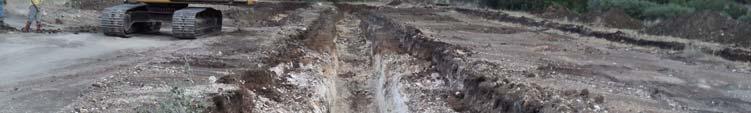


30 Release Investigation Report SWMU B-27 Photo 5. Excavated Trench 2, looking northwest (July 2011). Photo 6. Excavated Trench 5, looking northwest (July 2011). J:\CSSA PROGRAM\RESTORATION\SWMUS\SWMU B-27\RIR\FINAL RIR B-27.DOC A-3 RIR SWMU B-27 September 2011


31 Release Investigation Report SWMU B-27 Photo 7. Sifting metal debris at SWMU B-27, looking west (July 2011). Photo 8. MD found at SWMU B-27, looking south (July 2011). J:\CSSA PROGRAM\RESTORATION\SWMUS\SWMU B-27\RIR\FINAL RIR B-27.DOC A-4 RIR SWMU B-27 September 2011


. Photo 10.")


32 Release Investigation Report SWMU B-27 Photo 9. Confirmation sampling at Trench 1, looking southeast (July 2011). Photo 10. Final graded site, looking west (July 2011). J:\CSSA PROGRAM\RESTORATION\SWMUS\SWMU B-27\RIR\FINAL RIR B-27.DOC A-5 RIR SWMU B-27 September 2011
33 Release Investigation Report SWMU B-27 APPENDIX B Tier 1 Ecological Exclusion Criteria Checklist J:\CSSA PROGRAM\RESTORATION\SWMUS\SWMU B-27\RIR\FINAL RIR B-27.DOC A-1 RIR SWMU B-27 September 2011
34 Release Investigation Report SWMU B-27 TIER 1: Exclusion Criteria Checklist Figure: 30 TAC (b) This exclusion criteria checklist is intended to aid the person and the TNRCC in determining whether or not further ecological evaluation is necessary at an affected property where a response action is being pursued under the Texas Risk Reduction Program (TRRP). Exclusion criteria refer to those conditions at an affected property which preclude the need for a formal ecological risk assessment (ERA) because there are incomplete or insignificant ecological exposure pathways due to the nature of the affected property setting and/or the condition of the affected property media. This checklist (and/or a Tier 2 or 3 ERA or the equivalent) must be completed by the person for all affected property subject to the TRRP. The person should be familiar with the affected property but need not be a professional scientist in order to respond, although some questions will likely require contacting a wildlife management agency (i.e., Texas Parks and Wildlife Department or U.S. Fish and Wildlife Service). The checklist is designed for general applicability to all affected property; however, there may be unusual circumstances which require professional judgement in order to determine the need for further ecological evaluation (e.g., cave-dwelling receptors). In these cases, the person is strongly encouraged to contact TNRCC before proceeding. Besides some preliminary information, the checklist consists of three major parts, each of which must be completed unless otherwise instructed. PART I requests affected property identification and background information. PART II contains the actual exclusion criteria and supportive information. PART III is a qualitative summary statement and a certification of the information provided by the person. Answers should reflect existing conditions and should not consider future remedial actions at the affected property. Completion of the checklist should lead to a logical conclusion as to whether further evaluation is warranted. Definitions of terms used in the checklist have been provided and users are strongly encouraged to familiarize themselves with these definitions before beginning the checklist. Name of Facility: Camp Stanley Storage Activity (CSSA), Boerne, Texas. Affected Property Location: SWMU B-27 is located in the northwest portion of the Inner Cantonment area (see Figure 2 of this RIR). The site lies approximately 650 yards east of the western CSSA boundary and is approximately 2 acres in size. Mailing Address: Camp Stanley Storage Activity Ralph Fair Road Boerne, TX TNRCC Case Tracking #s: Water Customer No.: CN Air Customer No.: CN Solid Waste Registration #s: Texas Solid Waste Registration No.: Voluntary Cleanup Program #: Not applicable. EPA I.D. #s: USEPA Identification No.: TX J:\CSSA PROGRAM\RESTORATION\SWMUS\SWMU B-27\RIR\FINAL RIR B-27.DOC B-1 RIR SWMU B-27 September 2011
35 Release Investigation Report SWMU B-27 Figure: 30 TAC (b) Definitions 1 Affected property - The entire area (i.e., on-site and off-site; including all environmental media) which contains releases of chemicals of concern at concentrations equal to or greater than the assessment level applicable for residential land use and groundwater classification. Assessment level - A critical protective concentration level for a chemical of concern used for affected property assessments where the human health protective concentration level is established under a Tier 1 evaluation as described in (b) of this title (relating to Tiered Human Health Protective Concentration Level Evaluation), except for the protective concentration level for the soil-to-groundwater exposure pathway which may be established under Tier 1, 2, or 3 as described in (i)(7) of this title, and ecological protective concentration levels which are developed, when necessary, under Tier 2 and/or 3 in accordance with (c) and/or (d), respectively, of this title (relating to Ecological Risk Assessment and Development of Ecological Protective Concentration Levels). Bedrock - The solid rock (i.e., consolidated, coherent, and relatively hard naturally formed material that cannot normally be excavated by manual methods alone) that underlies gravel, soil or other surficial material. Chemical of concern - Any chemical that has the potential to adversely affect ecological or human receptors due to its concentration, distribution, and mode of toxicity. Depending on the program area, chemicals of concern may include the following: solid waste, industrial solid waste, municipal solid waste, and hazardous waste as defined in Texas Health and Safety Code, , as amended; hazardous constituents as listed in 40 Code of Federal Regulations Part 261, Appendix VIII, as amended; constituents on the groundwater monitoring list in 40 Code of Federal Regulations Part 264, Appendix IX, as amended; constituents as listed in 40 CFR Part 258 Appendices I and II, as amended; pollutant as defined in Texas Water Code, , as amended; hazardous substance as defined in Texas Health and Safety Code, , as amended, and the Texas Water Code , as amended; regulated substance as defined in Texas Water Code , as amended and of this title (relating to Definitions), as amended; petroleum product as defined in Texas Water Code , as amended and (b)(12) of this title (relating to Definitions for ASTs), as amended; other substances as defined in Texas Water Code (a), as amended; and daughter products of the aforementioned constituents. Community - An assemblage of plant and animal populations occupying the same habitat in which the various species interact via spatial and trophic relationships (e.g., a desert community or a pond community). Complete exposure pathway - An exposure pathway where a human or ecological receptor is exposed to a chemical of concern via an exposure route (e.g., incidental soil ingestion, inhalation of volatiles and particulates, consumption of prey, etc). De minimus - The description of an area of affected property comprised of one acre or less where the ecological risk is considered to be insignificant because of the small extent of contamination, the absence of protected species, the availability of similar unimpacted habitat nearby, and the lack of adjacent sensitive environmental areas. Ecological protective concentration level - The concentration of a chemical of concern at the point of exposure within an exposure medium (e.g., soil, sediment, groundwater, or surface water) which is determined in accordance with (c) or (d) of this title (relating to Ecological Risk Assessment and Development of Ecological Protective Concentration Levels) to be protective for ecological receptors. These concentration levels are primarily intended to be protective for more mobile or wide-ranging ecological receptors and, where appropriate, benthic invertebrate communities within the waters in the state. These concentration levels are not intended to be directly protective of receptors with limited mobility or range (e.g., plants, soil invertebrates, and small rodents), particularly those residing within active areas of a facility, unless these receptors are threatened/endangered species or unless 1 These definitions were taken from 30 TAC and may have both ecological and human health applications. For the purposes of this checklist, it is understood that only the ecological applications are of concern. J:\CSSA PROGRAM\RESTORATION\SWMUS\SWMU B-27\RIR\FINAL RIR B-27.DOC B-2 RIR SWMU B-27 September 2011
36 Release Investigation Report SWMU B-27 impacts to these receptors result in disruption of the ecosystem or other unacceptable consequences for the more mobile or wide-ranging receptors (e.g., impacts to an off-site grassland habitat eliminate rodents which causes a desirable owl population to leave the area). Ecological risk assessment - The process that evaluates the likelihood that adverse ecological effects may occur or are occurring as a result of exposure to one or more stressors; however, as used in this context, only chemical stressors (i.e., COCs) are evaluated. Environmental medium - A material found in the natural environment such as soil (including non-waste fill materials), groundwater, air, surface water, and sediments, or a mixture of such materials with liquids, sludges, gases, or solids, including hazardous waste which is inseparable by simple mechanical removal processes, and is made up primarily of natural environmental material. Exclusion criteria - Those conditions at an affected property which preclude the need to establish a protective concentration level for an ecological exposure pathway because the exposure pathway between the chemical of concern and the ecological receptors is not complete or is insignificant. Exposure medium - The environmental medium or biologic tissue in which or by which exposure to chemicals of concern by ecological or human receptors occurs. Facility - The installation associated with the affected property where the release of chemicals of concern occurred. Functioning cap - A low permeability layer or other approved cover meeting its design specifications to minimize water infiltration and chemical of concern migration, and prevent ecological or human receptor exposure to chemicals of concern, and whose design requirements are routinely maintained. Landscaped area - An area of ornamental, or introduced, or commercially installed, or manicured vegetation which is routinely maintained. Off-site property (off-site) - All environmental media which is outside of the legal boundaries of the on-site property. On-site property (on-site) - All environmental media within the legal boundaries of a property owned or leased by a person who has filed a self-implementation notice or a response action plan for that property or who has become subject to such action through one of the agency s program areas for that property. Physical barrier - Any structure or system, natural or manmade, that prevents exposure or prevents migration of chemicals of concern to the points of exposure. Point of exposure - The location within an environmental medium where a receptor will be assumed to have a reasonable potential to come into contact with chemicals of concern. The point of exposure may be a discrete point, plane, or an area within or beyond some location. Protective concentration level - The concentration of a chemical of concern which can remain within the source medium and not result in levels which exceed the applicable human health risk-based exposure limit or ecological protective concentration level at the point of exposure for that exposure pathway. Release - Any spilling, leaking, pumping, pouring, emitting, emptying, discharging, injecting, escaping, leaching, dumping, or disposing into the environment, with the exception of: (A) A release that results in an exposure to a person solely within a workplace, concerning a claim that the person may assert against the person's employer; (B) An emission from the engine exhaust of a motor vehicle, rolling stock, aircraft, vessel, or pipeline pumping station engine; (C) A release of source, by-product, or special nuclear material from a nuclear incident, as those terms are defined by the Atomic Energy Act of 1954, as amended (42 U.S.C et seq.), if the release is subject to requirements concerning financial protection established by the Nuclear Regulatory Commission under 170 of that Act; J:\CSSA PROGRAM\RESTORATION\SWMUS\SWMU B-27\RIR\FINAL RIR B-27.DOC B-3 RIR SWMU B-27 September 2011
37 Release Investigation Report SWMU B-27 (D) For the purposes of the environmental response law 104, as amended, or other response action, a release of source, by-product, or special nuclear material from a processing site designated under 102(a)(1) or 302(a) of the Uranium Mill Tailings Radiation Control Act of 1978 (42 U.S.C and 7942), as amended; and (E) The normal application of fertilizer. Sediment - Non-suspended particulate material lying below surface waters such as bays, the ocean, rivers, streams, lakes, ponds, or other similar surface water body (including intermittent streams). Dredged sediments which have been removed from below surface water bodies and placed on land shall be considered soils. Sensitive environmental areas - Areas that provide unique and often protected habitat for wildlife species. These areas are typically used during critical life stages such as breeding, hatching, rearing of young, and overwintering. Examples include critical habitat for threatened and endangered species, wilderness areas, parks, and wildlife refuges. Source medium - An environmental medium containing chemicals of concern which must be removed, decontaminated and/or controlled in order to protect human health and the environment. The source medium may be the exposure medium for some exposure pathways. Stressor - Any physical, chemical, or biological entity that can induce an adverse response; however, as used in this context, only chemical entities apply. Subsurface soil - For human health exposure pathways, the portion of the soil zone between the base of surface soil and the top of the groundwater-bearing unit(s). For ecological exposure pathways, the portion of the soil zone between 0.5 feet and 5 feet in depth. Surface cover - A layer of artificially placed utility material (e.g., shell, gravel). Surface soil - For human health exposure pathways, the soil zone extending from ground surface to 15 feet in depth for residential land use and from ground surface to 5 feet in depth for commercial/industrial land use; or to the top of the uppermost groundwater-bearing unit or bedrock, whichever is less in depth. For ecological exposure pathways, the soil zone extending from ground surface to 0.5 feet in depth. Surface water - Any water meeting the definition of surface water in the state as defined in of this title (relating to Abbreviations and Definitions), as amended. J:\CSSA PROGRAM\RESTORATION\SWMUS\SWMU B-27\RIR\FINAL RIR B-27.DOC B-4 RIR SWMU B-27 September 2011
38 Release Investigation Report SWMU B-27 PART I. Affected Property Identification and Background Information 1) Provide a description of the specific area of the response action and the nature of the release. Include estimated acreage of the affected property and the facility property, and a description of the type of facility and/or operation associated with the affected property. Also describe the location of the affected property with respect to the facility property boundaries and public roadways. Camp Stanley Storage Activity: CSSA is located in northwestern Bexar County, about 19 miles northwest of downtown San Antonio. The installation consists of approximately 4,004 acres immediately east of Ralph Fair Road, and approximately 0.5 mile east of Interstate Highway 10 (see Figure 1 of the RIR). CSSA has several historical waste sites, including SWMUs, AOCs, and RMUs. The present mission of CSSA is the receipt, storage, issue, and maintenance of ordnance as well as quality assurance testing and maintenance of military weapons and ammunition. Because of its mission, CSSA has been designated a restricted access facility. No changes to the CSSA mission and/or military activities are expected in the future. SWMU B-27 is located in the northwest portion of the Inner Cantonment area. The site lies approximately 650 yards east of the western CSSA boundary and covers approximately 2 acres. Prior to the excavation activities described herein, the area was open and covered by grass. The site is bounded by roads to the east, south, and west. An intermittent creek bed lies just north of the site. Several low soil mounds and shallow trenches originally ran the length of the site, ranging in length from 375 to 525 ft. The crests of the soil mounds had a rounded shape suggestive of erosion since the time of their emplacement. The trenches were less than ten feet wide. Attach available USGS topographic maps and/or aerial or other affected property photographs to this form to depict the affected property and surrounding area. Indicate attachments: Topo map Aerial photo Other Aerial photos of the site and land adjacent to the site are shown on Figure 3 of the RIR. Figure 2 of the RIR shows the general location of SWMU B-27. 2) Identify environmental media known or suspected to contain chemicals of concern (COCs) at the present time. Check all that apply: Known/Suspected COC Location Based on sampling data? NO Soil 5 ft below ground surface Yes No NO Soil >5 ft below ground surface Yes No NO Groundwater Yes No NO Surface Water/Sediments Yes No Explain (previously submitted information may be referenced): Based on soil samples collected at SWMU B-27, there are no VOCs or SVOCs at the sites (see Appendix C of this RIR). Metals with concentrations exceeding Tier 1 PCLs at the site were excavated and removed or used to calculate a 95% UCL per TAC (2)(A) that does not exceed the Tier 1 PCL. There is no evidence of other affected or threatened environmental media (groundwater, surface water, or sediment) at SWMU B-27. Inorganic groundwater contamination has not been reported in the closest well to SWMU B-27 (well CS-MW19-LGR located approximately 830 feet downgradient). Low concentrations of VOCs detected in CS-MW19-LGR (below their MCLs) are attributed to contaminated groundwater from Plume 2. Additionally, since soils found to have concentrations of J:\CSSA PROGRAM\RESTORATION\SWMUS\SWMU B-27\RIR\FINAL RIR B-27.DOC B-5 RIR SWMU B-27 September 2011
39 Release Investigation Report SWMU B-27 metals above their PCLs were excavated and removed, there will be no impact to groundwater, surface water, or sediment from SWMU B-27. 3) Provide the information below for the nearest surface water body which has become or has the potential to become impacted from migrating COCs via surface water runoff, air deposition, groundwater seepage, etc. Exclude wastewater treatment facilities and stormwater conveyances/impoundments authorized by permit. Also exclude conveyances, decorative ponds, and those portions of process facilities which are: a. Not in contact with surface waters in the State or other surface waters which are ultimately in contact with surface waters in the State; and b. Not consistently or routinely utilized as valuable habitat for natural communities including birds, mammals, reptiles, etc. The nearest surface water body, an unnamed tributary that drains to Salado Creek, is approximately 35 feet from the affected property (north of SWMU B-27). The water body is best described as a: freshwater stream: perennial (has water all year) intermittent (dries up completely for at least 1 week a year) [only has water during and immediately after rain events] intermittent with perennial pools freshwater swamp/marsh/wetland saltwater or brackish marsh/swamp/wetland reservoir, lake, or pond; approximate surface acres: drainage ditch tidal stream bay estuary other; specify Is the water body listed as a State classified segment in Appendix C of the current Texas Surface Water Quality Standards; ? No Yes Segment # Use Classification: If the water body is not a State classified segment, identify the first downstream classified segment. Name: Salado Creek Segment #: Segment From the confluence with the San Antonio River in Bexar County to Rocking Horse Lane west of Camp Bullis in Bexar County. Use Classification: Salado Creek is classified as an intermittent creek upstream (south) of CSSA to Loop 410 in San Antonio. The creek is classified as perennial downstream of Loop 410. The distance downgradient of SWMU B-27 to perennial surface water of Salado Creek is approximately 21.6 miles. Although water uses are not distinguished between the upstream intermittent and the downstream perennial sections, the designated uses of Segment 1910 as a whole are high aquatic life, contact recreation, public water J:\CSSA PROGRAM\RESTORATION\SWMUS\SWMU B-27\RIR\FINAL RIR B-27.DOC B-6 RIR SWMU B-27 September 2011
40 Release Investigation Report SWMU B-27 supply, and aquifer protection. No significant degradation of high quality receiving waters is anticipated from SWMU B-27. As necessary, provide further description of surface waters in the vicinity of the affected property: PART II. Exclusion Criteria and Supportive Information Subpart A. Surface Water/Sediment Exposure 1) Regarding the affected property where a response action is being pursued under the TRRP, have COCs migrated and resulted in a release or imminent threat of release to either surface waters or to their associated sediments via surface water runoff, air deposition, groundwater seepage, etc.? Exclude wastewater treatment facilities and stormwater conveyances/impoundments authorized by permit. Also exclude conveyances, decorative ponds, and those portions of process facilities which are: a. Not in contact with surface waters in the State or other surface waters which are ultimately in contact with surface waters in the State; and b. Not consistently or routinely utilized as valuable habitat for natural communities including birds, mammals, reptiles, etc. Yes No Explain: There is no evidence of other affected or threatened environmental media (groundwater, surface water, or sediment) at SWMU B-27. Since soils that were found to have concentrations of metals above their PCLs were excavated/removed, there will be no impact to groundwater, surface water, or sediment from SWMU B-27. The closest surface water body to SWMU B-27 is an unnamed tributary approximately 35 ft north of the site that drains to Salado Creek. This creek, and all other creeks at CSSA, are intermittent and only contain water during and immediately following rain events. If the answer is Yes to Subpart A above, the affected property does not meet the exclusion criteria. However, complete the remainder of Part II to determine if there is a complete and/or significant soil exposure pathway, then complete PART III - Qualitative Summary and Certification. If the answer is No, go to Subpart B. Subpart B. Affected Property Setting In answering Yes to the following question, it is understood that the affected property is not attractive to wildlife or livestock, including threatened or endangered species (i.e., the affected property does not serve as valuable habitat, foraging area, or refuge for ecological communities). (May require consultation with wildlife management agencies.) 1) Is the affected property wholly contained within contiguous land characterized by: pavement, buildings, landscaped area, functioning cap, roadways, equipment storage area, manufacturing or process area, other surface cover or structure, or otherwise disturbed ground? Yes No Explain: Concentrations of chemicals detected in soil samples at SWMU B-27 do not exceed Tier 1 residential soil action levels. Soils found to have metals concentrations above their PCLs were excavated and removed J:\CSSA PROGRAM\RESTORATION\SWMUS\SWMU B-27\RIR\FINAL RIR B-27.DOC B-7 RIR SWMU B-27 September 2011
41 Release Investigation Report SWMU B-27 from the site or were used to calculate a 95% UCL per TAC (2)(A) that does not exceed the Tier 1 PCL. There is no evidence of other affected or threatened environmental media (groundwater, surface water, or sediment) at SWMU B-27. Since soils found to have concentrations of metals above their PCLs were excavated/removed, there will be no impact to groundwater, surface water, or sediment in the area. Inorganic groundwater contamination has not been reported in the closest well to SWMU B-27 (well CS-MW19-LGR located approximately 830 feet downgradient of the site). Additionally, several surveys have been conducted at CSSA for T&E species. The only T&E species that have been documented at CSSA are the black-capped vireo (Vireo atricapillus) [BCVI] and golden-cheeked warbler (Dendroica chrysoparia) [GCWA]. SWMU B-27 is not located within BCVI or GCWA habitat. The nearest potential habitats for local endangered species are approximately 4,400 ft east. Additional information can be found in the following references: Parsons, Final Integrated Natural Resource Management Plan. Prepared for Camp Stanley Storage Activity, Boerne, Texas. October Available online: CSSA EE (Volume 1.6, Other Plans and Approaches) Parsons, Final Species and Habitat Distributions of Black-Capped Vireos and Golden-Cheeked Warblers, 2009 Breeding/Nesting Season. Prepared for Camp Stanley Storage Activity, Boerne, Texas. September Available online: CSSA EE (Volume 1.6, Other Plans and Approaches) If the answer to Subpart B above is Yes, the affected property meets the exclusion criteria, assuming the answer to Subpart A was No. Skip Subparts C and D and complete PART III - Qualitative Summary and Certification. If the answer to Subpart B above is No, go to Subpart C. Subpart C. Soil Exposure 1) Are COCs which are in the soil of the affected property solely below the first 5 feet beneath ground surface or does the affected property have a physical barrier present to prevent exposure of receptors to COCs in surface soil? Yes See explanation No Explain: Based on Table 1 of this RIR there are no longer any COCs at the site. What contaminated soil horizon that was present at the site was removed during excavation activities. If the answer to Subpart C above is Yes, the affected property meets the exclusion criteria, assuming the answer to Subpart A was No. Skip Subpart D and complete PART III - Qualitative Summary and Certification. If the answer to Subpart C above is No, proceed to Subpart D. Subpart D. De Minimus Land Area Subpart D skipped based on answers to Subparts A and C. In answering Yes to the question below, it is understood that all of the following conditions apply: The affected property is not known to serve as habitat, foraging area, or refuge to threatened/endangered or otherwise protected species. (Will likely require consultation with wildlife management agencies.) Similar but unimpacted habitat exists within a half-mile radius. The affected property is not known to be located within one-quarter mile of sensitive environmental areas (e.g., rookeries, wildlife management areas, preserves). (Will likely require consultation with wildlife management agencies.) There is no reason to suspect that the COCs associated with the affected property will migrate such that the affected property will become larger than one acre. J:\CSSA PROGRAM\RESTORATION\SWMUS\SWMU B-27\RIR\FINAL RIR B-27.DOC B-8 RIR SWMU B-27 September 2011
42 Release Investigation Report SWMU B-27 1) Using human health protective concentration levels as a basis to determine the extent of the COCs, does the affected property consist of one acre or less and does it meet all of the conditions above? Yes No Explain how conditions are met/not met: If the answer to Subpart D above is Yes, then no further ecological evaluation is needed at this affected property, assuming the answer to Subpart A was No. Complete PART III - Qualitative Summary and Certification. If the answer to Subpart D above is No, proceed to Tier 2 or 3 or comparable ERA. J:\CSSA PROGRAM\RESTORATION\SWMUS\SWMU B-27\RIR\FINAL RIR B-27.DOC B-9 RIR SWMU B-27 September 2011
43 Release Investigation Report SWMU B-27 PART III. Qualitative Summary and Certification (Complete in all cases). Attach a brief statement (not to exceed 1 page) summarizing the information you have provided in this form. This summary should include sufficient information to verify that the affected property meets or does not meet the exclusion criteria. The person should make the initial decision regarding the need for further ecological evaluation (i.e., Tier 2 or 3) based upon the results of this checklist. After review, TNRCC will make a final determination on the need for further assessment. Note that the person has the continuing obligation to re-enter the ERA process if changing circumstances result in the affected property not meeting the Tier 1 exclusion criteria. Completed by: Laura Marbury, P.G. (Typed/Printed Name) Principal Geologist (Title) September 26, 2011 (Date) I believe that the information submitted is true, accurate, and complete, to the best of my knowledge. Julie Burdey, P.G. (Typed/Printed Name of Person) Project Manager (Title of Person) (Signature of Person) September 26, 2011 (Date Signed) J:\CSSA PROGRAM\RESTORATION\SWMUS\SWMU B-27\RIR\FINAL RIR B-27.DOC B-10 RIR SWMU B-27 September 2011
44 Release Investigation Report SWMU B-27 APPENDIX C Confirmation Sample Results for All Analytes at SWMU B-27 J:\CSSA PROGRAM\RESTORATION\SWMUS\SWMU B-27\RIR\FINAL RIR B-27.DOC RIR SWMU B-27 September 2011
45 Appendix C. Summary of Chemical Constituents Remaining in Soils at SWMU B 27 Volatile Organics Tier 1 Soil PCLs 30 acre 1,1,1,2 Tetrachloroethane CAS: ,1,1 Trichloroethane CAS: ,1,2,2 Tetrachloroethane CAS: ,1,2 Trichloroethane CAS: ,1 Dichloroethane CAS: ,1 Dichloroethene CAS: Residential Combined Exposure [1] 3.90E+01 c 3.20E+04 n 3.00E+01 c 1.00E+01 c 8.80E+03 n 1.60E+03 n 2.60E+01 c 8.70E+01 n 2.00E 01 c 7.00E+01 n 7.90E+01 n 8.00E 02 c 4.30E 01 c 3.90E+02 n Residential Groundwater Exposure [2] 7.10E 01 c 8.10E 01 m 1.20E 02 c 1.00E 02 m 9.20E+00 n 2.50E 02 m 6.70E 02 c 1.30E+01 n 2.70E 04 c 2.40E+00 m 2.40E+01 n 8.70E 04 m 1.00E 04 m 8.90E+00 m TCEQ Approved Background Values CSSA 9 Metals Background Concentration [3] na na na na na na na na na na na na na na Sample Locations (Date Collected) B27 SS01 (28 Jun 2011) B27 SS01 DUP (28 Jun 2011) B27 SS02 (28 Jun 2011) B27 SS03 (06 Jul 2011) U U U U U U U U U U U U U U 1 B27 SS04 (06 Jul 2011) U U U U U U U U U U U U U U 1 B27 SS05 (18 Jul 2011) U U U U U U U U U U U U U U 1 B27 SS06 (19 Jul 2011) U U U U U U U U U U U U U U 1 B27 SS07 (19 Jul 2011) U U U U U U U U U U U U U U 1 B27 SS08 (19 Jul 2011) U U U U U U U U U U U U U U 1 B27 SS09 (09 Aug 2011) U U U U U U U U U U U U U U 1 B27 SS09 DUP (09 Aug 2011) U U U U U U U U U U U U U U 1 B27 SS10 (09 Aug 2011) U U U U U U U U U U U U U U 1 B27 SS11 (09 Aug 2011) U U U U U U U U U U U U U U 1 B27 SS12 (09 Aug 2011) U U U U U U U U U U U U U U 1 B27 SS13 (09 Aug 2011) U U U U U U U U U U U U U U 1 B27 SS14 (09 Aug 2011) U U U U U U U U U U U U U U 1 B27 SS15 (09 Aug 2011) U U U U U U U M U M U U U U 1 B27 SS16 (04 Aug 2011) U U U U U U U U U U U U U U 1 B27 SS17 (04 Aug 2011) U U U U U U U U U U U U U U 1 B27 SS18 (17 Aug 2011) U U U U U U U U U U U U U U 1 B27 SS19 (17 Aug 2011) U U U U U U U U U U U U U U 1 B27 SS20 (30 Aug 2011) B27 SS21 (30 Aug 2011) B27 SS22 (30 Aug 2011) B27 SW01 (28 Jun 2011) B27 SW02 (28 Jun 2011) B27 SW03 (28 Jun 2011) B27 SW04 (28 Jun 2011) B27 SW05 (28 Jun 2011) B27 SW06 (28 Jun 2011) B27 SW07 (28 Jun 2011) B27 SW08 (28 Jun 2011) B27 SW09 (28 Jun 2011) B27 SW10 (28 Jun 2011) B27 SW11 (28 Jun 2011) B27 SW11 DUP (28 Jun 2011) B27 SW12 (28 Jun 2011) B27 SW13 (06 Jul 2011) U U U U U U U U U U U U U U 1 B27 SW14 (06 Jul 2011) U U U U U U U U U U U U U U 1 B27 SW15 (18 Jul 2011) M M M M M M M M M M M M M M 1 B27 SW16 (18 Jul 2011) B27 SW17 (18 Jul 2011) B27 SW18 (18 Jul 2011) B27 SW19 (18 Jul 2011) B27 SW20 (18 Jul 2011) B27 SW21 (19 Jul 2011) B27 SW22 (19 Jul 2011) U U U U U U U U U U U U U U 1 B27 SW22 DUP (19 Jul 2011) U U U U U U U U U U U U U U 1 B27 SW23 (19 Jul 2011) B27 SW24 (19 Jul 2011) B27 SW25 (19 Jul 2011) B27 SW26 (19 Jul 2011) B27 SW27 (19 Jul 2011) B27 SW28 (19 Jul 2011) B27 SW29 (19 Jul 2011) 1,1 Dichloropropene CAS: ,2,3 Trichlorobenzene CAS: ,2,3 Trichloropropane CAS: ,2,4 Trichlorobenzene CAS: ,2,4 Trimethylbenzene CAS: ,2 Dibromo 3 chloropropane CAS: ,2 Dibromoethane (EDB) CAS: ,2 Dichlorobenzene CAS:
46 Appendix C. Summary of Chemical Constituents Remaining in Soils at SWMU B 27 Volatile Organics Tier 1 Soil PCLs 30 acre 1,1,1,2 Tetrachloroethane CAS: ,1,1 Trichloroethane CAS: ,1,2,2 Tetrachloroethane CAS: ,1,2 Trichloroethane CAS: ,1 Dichloroethane CAS: ,1 Dichloroethene CAS: Residential Combined Exposure [1] 3.90E+01 c 3.20E+04 n 3.00E+01 c 1.00E+01 c 8.80E+03 n 1.60E+03 n 2.60E+01 c 8.70E+01 n 2.00E 01 c 7.00E+01 n 7.90E+01 n 8.00E 02 c 4.30E 01 c 3.90E+02 n Residential Groundwater Exposure [2] 7.10E 01 c 8.10E 01 m 1.20E 02 c 1.00E 02 m 9.20E+00 n 2.50E 02 m 6.70E 02 c 1.30E+01 n 2.70E 04 c 2.40E+00 m 2.40E+01 n 8.70E 04 m 1.00E 04 m 8.90E+00 m TCEQ Approved Background Values CSSA 9 Metals Background Concentration [3] na na na na na na na na na na na na na na Sample Locations (Date Collected) B27 SW30 (19 Jul 2011) B27 SW31 (19 Jul 2011) B27 SW32 (19 Jul 2011) B27 SW33 (19 Jul 2011) B27 SW34 (19 Jul 2011) B27 SW35 (19 Jul 2011) U U U U U U U U U U U U U U 1 B27 SW35 DUP (19 Jul 2011) U U U U U U U U U U U U U U 1 B27 SW36 (19 Jul 2011) B27 SW37 (19 Jul 2011) B27 SW38 (19 Jul 2011) B27 SW39 (19 Jul 2011) B27 SW40 (19 Jul 2011) B27 SW41 (19 Jul 2011) B27 SW42 (19 Jul 2011) B27 SW43 (19 Jul 2011) U U U U U U U U U U U U U U 1 B27 SW44 (19 Jul 2011) B27 SW45 (19 Jul 2011) B27 SW46 (19 Jul 2011) B27 SW47 (19 Jul 2011) B27 SW48 (19 Jul 2011) B27 SW48 DUP (19 Jul 2011) B27 SW49 (19 Jul 2011) B27 SW50 (19 Jul 2011) B27 SW51 (19 Jul 2011) B27 SW52 (19 Jul 2011) B27 SW53 (19 Jul 2011) B27 SW54 (19 Jul 2011) U U U U U U U U U U U U U U 1 B27 SW55 (19 Jul 2011) B27 SW56 (19 Jul 2011) B27 SW57 (09 Aug 2011) B27 SW58 (09 Aug 2011) B27 SW59 (09 Aug 2011) B27 SW60 (09 Aug 2011) B27 SW61 (09 Aug 2011) B27 SW61 DUP (09 Aug 2011) B27 SW62 (09 Aug 2011) B27 SW63 (09 Aug 2011) B27 SW64 (09 Aug 2011) B27 SW65 (09 Aug 2011) B27 SW66 (09 Aug 2011) B27 SW67 (09 Aug 2011) 1,1 Dichloropropene CAS: ,2,3 Trichlorobenzene CAS: ,2,3 Trichloropropane CAS: ,2,4 Trichlorobenzene CAS: ,2,4 Trimethylbenzene CAS: ,2 Dibromo 3 chloropropane CAS: ,2 Dibromoethane (EDB) CAS: ,2 Dichlorobenzene CAS:
47 Appendix C. Summary of Chemical Constituents Remaining in Soils at SWMU B 27 Volatile Organics Tier 1 Soil PCLs 30 acre 1,2 Dichloroethane CAS: ,2 Dichloropropane CAS: ,3,5 Trimethylbenzene (Mesitylene) CAS: ,3 Dichlorobenzene CAS: ,3 Dichloropropane CAS: ,4 Dichlorobenzene CAS: Residential Combined Exposure [1] 6.40E+00 c 3.10E+01 n 5.90E+01 n 6.20E+01 n 2.60E+01 c 2.50E+02 c 2.30E+03 n 3.10E+01 n 1.10E+03 n 1.60E+03 n 6.90E+01 c 2.80E+02 n 3.30E+03 n 9.80E+01 c Residential Groundwater Exposure [2] 6.90E 03 m 1.10E 02 m 2.70E+01 n 3.40E+00 n 3.20E 02 c 1.10E+00 m 2.00E+01 n 6.00E 02 c 4.50E+00 n 5.40E+00 n 1.30E 02 m 1.20E+00 n 1.50E+00 n 3.30E 02 c TCEQ Approved Background Values CSSA 9 Metals Background Concentration [3] na na na na na na na na na na na na na na Sample Locations (Date Collected) B27 SS01 (28 Jun 2011) B27 SS01 DUP (28 Jun 2011) B27 SS02 (28 Jun 2011) B27 SS03 (06 Jul 2011) U U U U U U U U U U U U U U 1 B27 SS04 (06 Jul 2011) U U U U U U U U U U U U U U 1 B27 SS05 (18 Jul 2011) U U U U U U U U U U U U U U 1 B27 SS06 (19 Jul 2011) U U U U U U U U U U U U U U 1 B27 SS07 (19 Jul 2011) U U U U U U U U U U U U U U 1 B27 SS08 (19 Jul 2011) U U U U U U U U U U U U U U 1 B27 SS09 (09 Aug 2011) U U U U U U U U U U U U U U 1 B27 SS09 DUP (09 Aug 2011) U U U U U U U U U U U U U U 1 B27 SS10 (09 Aug 2011) U U U U U U U U U U U U U U 1 B27 SS11 (09 Aug 2011) U U U U U U U U U U U U U U 1 B27 SS12 (09 Aug 2011) U U U U U U U U U U U U U U 1 B27 SS13 (09 Aug 2011) U U U U U U U U U U U U U U 1 B27 SS14 (09 Aug 2011) U U U U U U U U U U U U U U 1 B27 SS15 (09 Aug 2011) U U U U U U U M U U U U U U 1 B27 SS16 (04 Aug 2011) U U U U U U U U U U U U U U 1 B27 SS17 (04 Aug 2011) U U U U U U U U U U U U U U 1 B27 SS18 (17 Aug 2011) U U U U U U U U U U U U U U 1 B27 SS19 (17 Aug 2011) U U U U U U U U U U U U U U 1 B27 SS20 (30 Aug 2011) B27 SS21 (30 Aug 2011) B27 SS22 (30 Aug 2011) B27 SW01 (28 Jun 2011) B27 SW02 (28 Jun 2011) B27 SW03 (28 Jun 2011) B27 SW04 (28 Jun 2011) B27 SW05 (28 Jun 2011) 2011) B27 SW06 (28 Jun 2011) B27 SW07 (28 Jun 2011) B27 SW08 (28 Jun 2011) B27 SW09 (28 Jun 2011) B27 SW10 (28 Jun 2011) B27 SW11 (28 Jun 2011) B27 SW11 DUP (28 Jun 2011) B27 SW12 (28 Jun 2011) B27 SW13 (06 Jul 2011) U U U U U U U U U U U U U U 1 B27 SW14 (06 Jul 2011) U U U U U U U U U U U U U U 1 B27 SW15 (18 Jul 2011) U M M M M M M M M M M M U M 1 B27 SW16 (18 Jul 2011) B27 SW17 (18 Jul 2011) B27 SW18 (18 Jul 2011) B27 SW19 (18 Jul 2011) B27 SW20 (18 Jul 2011) B27 SW21 (19 Jul 2011) B27 SW22 (19 Jul 2011) U U U U U U U U U U U U U U 1 B27 SW22 DUP (19 Jul 2011) U U U U U U U U U U U U U U 1 B27 SW23 (19 Jul 2011) B27 SW24 (19 Jul 2011) B27 SW25 (19 Jul 2011) B27 SW26 (19 Jul 2011) B27 SW27 (19 Jul 2011) B27 SW28 (19 Jul 2011) B27 SW29 (19 Jul 2011) 1 Chlorohexane CAS: ,2 Dichloropropane CAS: Chlorotoluene CAS: Chlorotoluene CAS: Benzene CAS: Bromobenzene CAS: Bromochloromethane CAS: Bromodichloromethane CAS:
48 Appendix C. Summary of Chemical Constituents Remaining in Soils at SWMU B 27 Volatile Organics Tier 1 Soil PCLs 30 acre 1,2 Dichloroethane CAS: ,2 Dichloropropane CAS: ,3,5 Trimethylbenzene (Mesitylene) CAS: ,3 Dichlorobenzene CAS: ,3 Dichloropropane CAS: ,4 Dichlorobenzene CAS: Residential Combined Exposure [1] 6.40E+00 c 3.10E+01 n 5.90E+01 n 6.20E+01 n 2.60E+01 c 2.50E+02 c 2.30E+03 n 3.10E+01 n 1.10E+03 n 1.60E+03 n 6.90E+01 c 2.80E+02 n 3.30E+03 n 9.80E+01 c Residential Groundwater Exposure [2] 6.90E 03 m 1.10E 02 m 2.70E+01 n 3.40E+00 n 3.20E 02 c 1.10E+00 m 2.00E+01 n 6.00E 02 c 4.50E+00 n 5.40E+00 n 1.30E 02 m 1.20E+00 n 1.50E+00 n 3.30E 02 c TCEQ Approved Background Values CSSA 9 Metals Background Concentration [3] na na na na na na na na na na na na na na Sample Locations (Date Collected) B27 SW30 (19 Jul 2011) B27 SW31 (19 Jul 2011) B27 SW32 (19 Jul 2011) B27 SW33 (19 Jul 2011) B27 SW34 (19 Jul 2011) B27 SW35 (19 Jul 2011) U U U U U U U U U U U U U U 1 B27 SW35 DUP (19 Jul 2011) U U U U U U U U U U U U U U 1 B27 SW36 (19 Jul 2011) B27 SW37 (19 Jul 2011) B27 SW38 (19 Jul 2011) B27 SW39 (19 Jul 2011) B27 SW40 (19 Jul 2011) B27 SW41 (19 Jul 2011) B27 SW42 (19 Jul 2011) B27 SW43 (19 Jul 2011) U U U U U U U U U U U U U U 1 B27 SW44 (19 Jul 2011) B27 SW45 (19 Jul 2011) B27 SW46 (19 Jul 2011) B27 SW47 (19 Jul 2011) B27 SW48 (19 Jul 2011) B27 SW48 DUP (19 Jul 2011) B27 SW49 (19 Jul 2011) B27 SW50 (19 Jul 2011) B27 SW51 (19 Jul 2011) B27 SW52 (19 Jul 2011) B27 SW53 (19 Jul 2011) B27 SW54 (19 Jul 2011) U U U U U U U U U U U U U U 1 B27 SW55 (19 Jul 2011) B27 SW56 (19 Jul 2011) B27 SW57 (09 Aug 2011) B27 SW58 (09 Aug 2011) B27 SW59 (09 Aug 2011) B27 SW60 (09 Aug 2011) B27 SW61 (09 Aug 2011) B27 SW61 DUP (09 Aug 2011) B27 SW62 (09 Aug 2011) B27 SW63 (09 Aug 2011) B27 SW64 (09 Aug 2011) B27 SW65 (09 Aug 2011) B27 SW66 (09 Aug 2011) B27 SW67 (09 Aug 2011) B27 SW68 (09 Aug 2011) B27 SW69 (09 Aug 2011) B27 SW70 (04 Aug 2011) B27 SW71 (04 Aug 2011) B27 SW72 (04 Aug 2011) B27 SW72 DUP (04 Aug 2011) B27 SW73 (04 Aug 2011) B27 SW74 (04 Aug 2011) B27 SW74 DUP (04 Aug 2011) B27 SW75 (04 Aug 2011) B27 SW76 (04 Aug 2011) B27 SW77 (04 Aug 2011) B27 SW78 (04 Aug 2011) B27 SW79 (17 Aug 2011) B27 SW80 (17 Aug 2011) B27 SW81 (17 Aug 2011) B27 SW82 (17 Aug 2011) B27 SW83 (17 Aug 2011) B27 SW83 DUP (17 Aug 2011) B27 SW84 (17 Aug 2011) B27 SW85 (23 Aug 2011) B27 SW86 (23 Aug 2011) 1 Chlorohexane CAS: ,2 Dichloropropane CAS: Chlorotoluene CAS: Chlorotoluene CAS: Benzene CAS: Bromobenzene CAS: Bromochloromethane CAS: Bromodichloromethane CAS:
49 Appendix C. Summary of Chemical Constituents Remaining in Soils at SWMU B 27 Volatile Organics Tier 1 Soil PCLs 30 acre Bromoform CAS: Bromomethane CAS: Carbon tetrachloride CAS: Chlorobenzene CAS: Chloroethane CAS: Chloroform CAS: Residential Combined Exposure [1] 2.80E+02 c 2.90E+01 n 2.30E+01 c 3.20E+02 n 2.30E+04 n 8.00E+00 c 8.40E+01 c 1.20E+02 n 7.80E+00 n 7.20E+01 c 4.20E+01 n 7.50E+02 n 5.30E+03 n 1.20E+01 c Residential Groundwater Exposure [2] 3.20E 01 c 6.50E 02 n 3.10E 02 m 5.50E 01 m 1.50E+01 n 5.10E 01 n 2.00E 01 c 1.20E 01 m 3.30E 03 c 2.50E 02 c 5.60E 01 c 1.20E+02 n 3.80E+00 m 1.60E+00 c TCEQ Approved Background Values CSSA 9 Metals Background Concentration [3] na na na na na na na na na na na na na na Sample Locations (Date Collected) B27 SS01 (28 Jun 2011) B27 SS01 DUP (28 Jun 2011) B27 SS02 (28 Jun 2011) B27 SS03 (06 Jul 2011) U U U U U U U U U U U U U U 1 B27 SS04 (06 Jul 2011) U U U U U U U U U U U U U U 1 B27 SS05 (18 Jul 2011) U U U U U U U U U U U U U U 1 B27 SS06 (19 Jul 2011) U U U U U U U U U U U U U U 1 B27 SS07 (19 Jul 2011) U U U U U U U U U U U U U U 1 B27 SS08 (19 Jul 2011) U U U U U U U U U U U U U U 1 B27 SS09 (09 Aug 2011) U U U U U U U U U U U U U U 1 B27 SS09 DUP (09 Aug 2011) U U U U U U U U U U U U U U 1 B27 SS10 (09 Aug 2011) U U U U U U U U U U U U U U 1 B27 SS11 (09 Aug 2011) U U U U U U U U U U U U U U 1 B27 SS12 (09 Aug 2011) U U U U U U U U U U U U U U 1 B27 SS13 (09 Aug 2011) U U U U U U U U U U U U U U 1 B27 SS14 (09 Aug 2011) U U U U U U U U U U U U U U 1 B27 SS15 (09 Aug 2011) U U U U U U U M U U U U U U 1 B27 SS16 (04 Aug 2011) U U U U U U U U U U U U U U 1 B27 SS17 (04 Aug 2011) U U U U U U U U U U U U U U 1 B27 SS18 (17 Aug 2011) U U U U U U U U U U U U U U 1 B27 SS19 (17 Aug 2011) U U U U U U U U U U U U U U 1 B27 SS20 (30 Aug 2011) B27 SS21 (30 Aug 2011) B27 SS22 (30 Aug 2011) B27 SW01 (28 Jun 2011) B27 SW02 (28 Jun 2011) B27 SW03 (28 Jun 2011) B27 SW04 (28 Jun 2011) B27 SW05 (28 Jun 2011) 2011) B27 SW06 (28 Jun 2011) B27 SW07 (28 Jun 2011) B27 SW08 (28 Jun 2011) B27 SW09 (28 Jun 2011) B27 SW10 (28 Jun 2011) B27 SW11 (28 Jun 2011) B27 SW11 DUP (28 Jun 2011) B27 SW12 (28 Jun 2011) B27 SW13 (06 Jul 2011) U U U U U U U U U U U U U U 1 B27 SW14 (06 Jul 2011) U U U U U U U U U U U U U U 1 B27 SW15 (18 Jul 2011) M M M M M M M M M M U M M M 1 B27 SW16 (18 Jul 2011) B27 SW17 (18 Jul 2011) B27 SW18 (18 Jul 2011) B27 SW19 (18 Jul 2011) B27 SW20 (18 Jul 2011) B27 SW21 (19 Jul 2011) B27 SW22 (19 Jul 2011) U U U U U U U U U U U U U U 1 B27 SW22 DUP (19 Jul 2011) U U U U U U U U U U U U U U 1 B27 SW23 (19 Jul 2011) B27 SW24 (19 Jul 2011) B27 SW25 (19 Jul 2011) B27 SW26 (19 Jul 2011) B27 SW27 (19 Jul 2011) B27 SW28 (19 Jul 2011) B27 SW29 (19 Jul 2011) Chloromethane CAS: cis 1,2 Dichloroethene CAS: cis 1,3 Dichloropropene CAS: Dibromochloromethane CAS: Dibromomethane CAS: Dichlorodifluoromethane CAS: Ethylbenzene CAS: Hexachlorobutadiene CAS:
50 Appendix C. Summary of Chemical Constituents Remaining in Soils at SWMU B 27 Volatile Organics Tier 1 Soil PCLs 30 acre Bromoform CAS: Bromomethane CAS: Carbon tetrachloride CAS: Chlorobenzene CAS: Chloroethane CAS: Chloroform CAS: Residential Combined Exposure [1] 2.80E+02 c 2.90E+01 n 2.30E+01 c 3.20E+02 n 2.30E+04 n 8.00E+00 c 8.40E+01 c 1.20E+02 n 7.80E+00 n 7.20E+01 c 4.20E+01 n 7.50E+02 n 5.30E+03 n 1.20E+01 c Residential Groundwater Exposure [2] 3.20E 01 c 6.50E 02 n 3.10E 02 m 5.50E 01 m 1.50E+01 n 5.10E 01 n 2.00E 01 c 1.20E 01 m 3.30E 03 c 2.50E 02 c 5.60E 01 c 1.20E+02 n 3.80E+00 m 1.60E+00 c TCEQ Approved Background Values CSSA 9 Metals Background Concentration [3] na na na na na na na na na na na na na na Sample Locations (Date Collected) B27 SW30 (19 Jul 2011) B27 SW31 (19 Jul 2011) B27 SW32 (19 Jul 2011) B27 SW33 (19 Jul 2011) B27 SW34 (19 Jul 2011) B27 SW35 (19 Jul 2011) U U U U U U U U U U U U U U 1 B27 SW35 DUP (19 Jul 2011) U U U U U U U U U U U U U U 1 B27 SW36 (19 Jul 2011) B27 SW37 (19 Jul 2011) B27 SW38 (19 Jul 2011) B27 SW39 (19 Jul 2011) B27 SW40 (19 Jul 2011) B27 SW41 (19 Jul 2011) B27 SW42 (19 Jul 2011) B27 SW43 (19 Jul 2011) U U U U U U U U U U U U U U 1 B27 SW44 (19 Jul 2011) B27 SW45 (19 Jul 2011) B27 SW46 (19 Jul 2011) B27 SW47 (19 Jul 2011) B27 SW48 (19 Jul 2011) B27 SW48 DUP (19 Jul 2011) B27 SW49 (19 Jul 2011) B27 SW50 (19 Jul 2011) B27 SW51 (19 Jul 2011) B27 SW52 (19 Jul 2011) B27 SW53 (19 Jul 2011) B27 SW54 (19 Jul 2011) U U U U U U U U U U U U U U 1 B27 SW55 (19 Jul 2011) B27 SW56 (19 Jul 2011) B27 SW57 (09 Aug 2011) B27 SW58 (09 Aug 2011) B27 SW59 (09 Aug 2011) B27 SW60 (09 Aug 2011) B27 SW61 (09 Aug 2011) B27 SW61 DUP (09 Aug 2011) B27 SW62 (09 Aug 2011) B27 SW63 (09 Aug 2011) B27 SW64 (09 Aug 2011) B27 SW65 (09 Aug 2011) B27 SW66 (09 Aug 2011) B27 SW67 (09 Aug 2011) B27 SW68 (09 Aug 2011) B27 SW69 (09 Aug 2011) B27 SW70 (04 Aug 2011) B27 SW71 (04 Aug 2011) B27 SW72 (04 Aug 2011) B27 SW72 DUP (04 Aug 2011) B27 SW73 (04 Aug 2011) B27 SW74 (04 Aug 2011) B27 SW74 DUP (04 Aug 2011) B27 SW75 (04 Aug 2011) B27 SW76 (04 Aug 2011) B27 SW77 (04 Aug 2011) B27 SW78 (04 Aug 2011) B27 SW79 (17 Aug 2011) B27 SW80 (17 Aug 2011) B27 SW81 (17 Aug 2011) B27 SW82 (17 Aug 2011) B27 SW83 (17 Aug 2011) B27 SW83 DUP (17 Aug 2011) B27 SW84 (17 Aug 2011) B27 SW85 (23 Aug 2011) B27 SW86 (23 Aug 2011) Chloromethane CAS: cis 1,2 Dichloroethene CAS: cis 1,3 Dichloropropene CAS: Dibromochloromethane CAS: Dibromomethane CAS: Dichlorodifluoromethane CAS: Ethylbenzene CAS: Hexachlorobutadiene CAS:
51 Appendix C. Summary of Chemical Constituents Remaining in Soils at SWMU B 27 Volatile Organics Tier 1 Soil PCLs 30 acre Isopropylbenzene CAS: m,p Xylene CAS: Methylene chloride CAS: Naphthalene CAS: n Butylbenzene CAS: n Propylbenzene CAS: Residential Combined Exposure [1] 3.00E+03 n na 2.60E+02 c 1.20E+02 n 3.30E+03 n 1.60E+03 n 2.90E+04 n 8.20E+03 n 3.30E+03 n 4.30E+03 n 3.30E+03 n 9.40E+01 c 5.40E+03 n 3.70E+02 n Residential Groundwater Exposure [2] 1.70E+02 n na 6.50E 03 m 1.60E+01 n 7.60E+01 n 2.20E+01 n 3.50E+01 m 1.20E+02 n 4.20E+01 n 1.60E+00 m 5.00E+01 n 2.50E 02 m 4.10E+00 m 2.50E 01 m TCEQ Approved Background Values CSSA 9 Metals Background Concentration [3] na na na na na na na na na na na na na na Sample Locations (Date Collected) B27 SS01 (28 Jun 2011) B27 SS01 DUP (28 Jun 2011) B27 SS02 (28 Jun 2011) B27 SS03 (06 Jul 2011) U U U U U U U U U U U U U U 1 B27 SS04 (06 Jul 2011) U U U U U U U U U U U U U U 1 B27 SS05 (18 Jul 2011) U U U U U U U U U U U U U U 1 B27 SS06 (19 Jul 2011) U U U U U U U U U U U U U U 1 B27 SS07 (19 Jul 2011) U U U U U U U U U U U U U U 1 B27 SS08 (19 Jul 2011) U U U U U U U U U U U U U U 1 B27 SS09 (09 Aug 2011) U U U U U U U U U U U U U 1 B27 SS09 DUP (09 Aug 2011) U U U U U U U U U U U U U 1 B27 SS10 (09 Aug 2011) U U U U U U U U U U U U U 1 B27 SS11 (09 Aug 2011) U U F U U U U U U U U U U U 1 B27 SS12 (09 Aug 2011) U U U U U U U U U U U U U U 1 B27 SS13 (09 Aug 2011) U U F U U U U U U U U U U U 1 B27 SS14 (09 Aug 2011) U U U U U U U U U U U U U 1 B27 SS15 (09 Aug 2011) U U F M U U U U U U U U U U 1 B27 SS16 (04 Aug 2011) U U U U U U U U U U U U U U 1 B27 SS17 (04 Aug 2011) U U U U U U U U U U U U U U 1 B27 SS18 (17 Aug 2011) U U U U U U U U U U U U U U 1 B27 SS19 (17 Aug 2011) U U U U U U U U U U U U F U 1 B27 SS20 (30 Aug 2011) F 1 B27 SS21 (30 Aug 2011) U 1 B27 SS22 (30 Aug 2011) F 1 B27 SW01 (28 Jun 2011) B27 SW02 (28 Jun 2011) B27 SW03 (28 Jun 2011) B27 SW04 (28 Jun 2011) B27 SW05 (28 Jun 2011) 2011) B27 SW06 (28 Jun 2011) B27 SW07 (28 Jun 2011) B27 SW08 (28 Jun 2011) B27 SW09 (28 Jun 2011) B27 SW10 (28 Jun 2011) B27 SW11 (28 Jun 2011) B27 SW11 DUP (28 Jun 2011) B27 SW12 (28 Jun 2011) B27 SW13 (06 Jul 2011) U U U U U U U U U U U U U U 1 B27 SW14 (06 Jul 2011) U U U U U U U U U U U U U U 1 B27 SW15 (18 Jul 2011) M M U M M M M M M M M M M M 1 B27 SW16 (18 Jul 2011) B27 SW17 (18 Jul 2011) B27 SW18 (18 Jul 2011) B27 SW19 (18 Jul 2011) B27 SW20 (18 Jul 2011) B27 SW21 (19 Jul 2011) B27 SW22 (19 Jul 2011) U U U U U U U U U U U U U U 1 B27 SW22 DUP (19 Jul 2011) U U U U U U U U U U U U U U 1 B27 SW23 (19 Jul 2011) B27 SW24 (19 Jul 2011) B27 SW25 (19 Jul 2011) B27 SW26 (19 Jul 2011) B27 SW27 (19 Jul 2011) B27 SW28 (19 Jul 2011) B27 SW29 (19 Jul 2011) o Xylene CAS: CAS: p Cymene (p Isopropyltoluene) sec Butylbenzene CAS: Styrene CAS: tert Butylbenzene CAS: Tetrachloroethene (PCE) CAS: Toluene CAS: trans 1,2 Dichloroethene CAS:
52 Appendix C. Summary of Chemical Constituents Remaining in Soils at SWMU B 27 Volatile Organics Tier 1 Soil PCLs 30 acre Isopropylbenzene CAS: m,p Xylene CAS: Methylene chloride CAS: Naphthalene CAS: n Butylbenzene CAS: n Propylbenzene CAS: Residential Combined Exposure [1] 3.00E+03 n na 2.60E+02 c 1.20E+02 n 3.30E+03 n 1.60E+03 n 2.90E+04 n 8.20E+03 n 3.30E+03 n 4.30E+03 n 3.30E+03 n 9.40E+01 c 5.40E+03 n 3.70E+02 n Residential Groundwater Exposure [2] 1.70E+02 n na 6.50E 03 m 1.60E+01 n 7.60E+01 n 2.20E+01 n 3.50E+01 m 1.20E+02 n 4.20E+01 n 1.60E+00 m 5.00E+01 n 2.50E 02 m 4.10E+00 m 2.50E 01 m TCEQ Approved Background Values CSSA 9 Metals Background Concentration [3] na na na na na na na na na na na na na na Sample Locations (Date Collected) B27 SW30 (19 Jul 2011) B27 SW31 (19 Jul 2011) B27 SW32 (19 Jul 2011) B27 SW33 (19 Jul 2011) B27 SW34 (19 Jul 2011) B27 SW35 (19 Jul 2011) U U U U U U U U U U U U U U 1 B27 SW35 DUP (19 Jul 2011) U U U U U U U U U U U U U U 1 B27 SW36 (19 Jul 2011) B27 SW37 (19 Jul 2011) B27 SW38 (19 Jul 2011) B27 SW39 (19 Jul 2011) B27 SW40 (19 Jul 2011) B27 SW41 (19 Jul 2011) B27 SW42 (19 Jul 2011) B27 SW43 (19 Jul 2011) U U U U U U U U U U U U U U 1 B27 SW44 (19 Jul 2011) B27 SW45 (19 Jul 2011) B27 SW46 (19 Jul 2011) B27 SW47 (19 Jul 2011) B27 SW48 (19 Jul 2011) B27 SW48 DUP (19 Jul 2011) B27 SW49 (19 Jul 2011) B27 SW50 (19 Jul 2011) B27 SW51 (19 Jul 2011) B27 SW52 (19 Jul 2011) B27 SW53 (19 Jul 2011) B27 SW54 (19 Jul 2011) U U U U U U U U U U U U U U 1 B27 SW55 (19 Jul 2011) B27 SW56 (19 Jul 2011) B27 SW57 (09 Aug 2011) B27 SW58 (09 Aug 2011) B27 SW59 (09 Aug 2011) B27 SW60 (09 Aug 2011) B27 SW61 (09 Aug 2011) B27 SW61 DUP (09 Aug 2011) B27 SW62 (09 Aug 2011) B27 SW63 (09 Aug 2011) B27 SW64 (09 Aug 2011) B27 SW65 (09 Aug 2011) B27 SW66 (09 Aug 2011) B27 SW67 (09 Aug 2011) B27 SW68 (09 Aug 2011) B27 SW69 (09 Aug 2011) B27 SW70 (04 Aug 2011) B27 SW71 (04 Aug 2011) B27 SW72 (04 Aug 2011) B27 SW72 DUP (04 Aug 2011) B27 SW73 (04 Aug 2011) B27 SW74 (04 Aug 2011) B27 SW74 DUP (04 Aug 2011) B27 SW75 (04 Aug 2011) B27 SW76 (04 Aug 2011) B27 SW77 (04 Aug 2011) B27 SW78 (04 Aug 2011) B27 SW79 (17 Aug 2011) B27 SW80 (17 Aug 2011) B27 SW81 (17 Aug 2011) B27 SW82 (17 Aug 2011) B27 SW83 (17 Aug 2011) B27 SW83 DUP (17 Aug 2011) B27 SW84 (17 Aug 2011) B27 SW85 (23 Aug 2011) B27 SW86 (23 Aug 2011) o Xylene CAS: CAS: p Cymene (p Isopropyltoluene) sec Butylbenzene CAS: Styrene CAS: tert Butylbenzene CAS: Tetrachloroethene (PCE) CAS: Toluene CAS: trans 1,2 Dichloroethene CAS:
53 Appendix C. Summary of Chemical Constituents Remaining in Soils at SWMU B 27 Volatile Organics Semi Volatile Organics Tier 1 Soil PCLs 30 acre trans 1,3 Dichloropropene CAS: Trichloroethene (TCE) CAS: Trichlorofluoromethane CAS: Vinyl chloride CAS: ,2,4 Trichlorobenzene CAS: ,2 Dichlorobenzene CAS: Residential Combined Exposure [1] 2.60E+01 c 6.80E+01 n 2.50E+04 n 3.40E+00 c 7.00E+01 n 3.90E+02 n 6.20E+01 n 2.50E+02 c 6.70E+03 n 6.70E+01 n 2.00E+02 n 1.30E+03 n 1.30E+02 n 6.90E+00 c Residential Groundwater Exposure [2] 1.80E 02 c 1.70E 02 m 6.40E+01 n 1.10E 02 m 2.40E+00 m 8.90E+00 m 3.40E+00 n 1.10E+00 m 1.70E+01 n 8.70E 02 n 1.80E 01 n 1.60E+00 n 4.70E 02 n 2.70E 03 c TCEQ Approved Background Values CSSA 9 Metals Background Concentration [3] na na na na na na na na na na na na na na Sample Locations (Date Collected) B27 SS01 (28 Jun 2011) U U U U U U U U U U 1 B27 SS01 DUP (28 Jun 2011) U U U U U U U U U U 1 B27 SS02 (28 Jun 2011) U U U U U U U U U U 1 B27 SS03 (06 Jul 2011) U U U U 1 B27 SS04 (06 Jul 2011) U U U U 1 B27 SS05 (18 Jul 2011) U U U U U U U U U U U U U U 1 B27 SS06 (19 Jul 2011) U U U U U U U U U U U U U U 1 B27 SS07 (19 Jul 2011) U U U U U U U U U U U U U U 1 B27 SS08 (19 Jul 2011) U U U U U U U U U U U U U U 1 B27 SS09 (09 Aug 2011) U U U U U U U U U U U U U U 1 B27 SS09 DUP (09 Aug 2011) U U U U U U U U U U U U U U 1 B27 SS10 (09 Aug 2011) U U U U U U U U U U U U U U 1 B27 SS11 (09 Aug 2011) U U U U U U U U U U U U U U 1 B27 SS12 (09 Aug 2011) U U U U U U U U U U U U U U 1 B27 SS13 (09 Aug 2011) U U U U U U U U U U U U U U 1 B27 SS14 (09 Aug 2011) U U U U U U U U U U U U U U 1 B27 SS15 (09 Aug 2011) U U U U U U U U U U U U U U 1 B27 SS16 (04 Aug 2011) U U U U U U U U U U U U U U 1 B27 SS17 (04 Aug 2011) U U U U U U U U U U U U U U 1 B27 SS18 (17 Aug 2011) U U U U U U U U U U U U U U 1 B27 SS19 (17 Aug 2011) U U U U U U U U U U U U U U 1 B27 SS20 (30 Aug 2011) B27 SS21 (30 Aug 2011) B27 SS22 (30 Aug 2011) B27 SW01 (28 Jun 2011) B27 SW02 (28 Jun 2011) B27 SW03 (28 Jun 2011) U U U U U U U U U U 1 B27 SW04 (28 Jun 2011) B27 SW05 (28 Jun 2011) 2011) B27 SW06 (28 Jun 2011) B27 SW07 (28 Jun 2011) U U U U U U U U U U 1 B27 SW08 (28 Jun 2011) B27 SW09 (28 Jun 2011) B27 SW10 (28 Jun 2011) B27 SW11 (28 Jun 2011) B27 SW11 DUP (28 Jun 2011) B27 SW12 (28 Jun 2011) B27 SW13 (06 Jul 2011) U U U U 1 B27 SW14 (06 Jul 2011) U U U U 1 B27 SW15 (18 Jul 2011) M M U U U U U U U U U U U U 1 B27 SW16 (18 Jul 2011) B27 SW17 (18 Jul 2011) B27 SW18 (18 Jul 2011) B27 SW19 (18 Jul 2011) B27 SW20 (18 Jul 2011) B27 SW21 (19 Jul 2011) B27 SW22 (19 Jul 2011) U U U U U U U U U U U U U U 1 B27 SW22 DUP (19 Jul 2011) U U U U U U U U U U U U U U 1 B27 SW23 (19 Jul 2011) B27 SW24 (19 Jul 2011) B27 SW25 (19 Jul 2011) B27 SW26 (19 Jul 2011) B27 SW27 (19 Jul 2011) B27 SW28 (19 Jul 2011) B27 SW29 (19 Jul 2011) 1,3 Dichlorobenzene CAS: ,4 Dichlorobenzene CAS: ,4,5 Trichlorophenol CAS: ,4,6 Trichlorophenol CAS: ,4 Dichlorophenol CAS: ,4 Dimethylphenol CAS: ,4 Dinitrophenol CAS: ,4 Dinitrotoluene CAS:
54 Appendix C. Summary of Chemical Constituents Remaining in Soils at SWMU B 27 Volatile Organics Semi Volatile Organics Tier 1 Soil PCLs 30 acre trans 1,3 Dichloropropene CAS: Trichloroethene (TCE) CAS: Trichlorofluoromethane CAS: Vinyl chloride CAS: ,2,4 Trichlorobenzene CAS: ,2 Dichlorobenzene CAS: Residential Combined Exposure [1] 2.60E+01 c 6.80E+01 n 2.50E+04 n 3.40E+00 c 7.00E+01 n 3.90E+02 n 6.20E+01 n 2.50E+02 c 6.70E+03 n 6.70E+01 n 2.00E+02 n 1.30E+03 n 1.30E+02 n 6.90E+00 c Residential Groundwater Exposure [2] 1.80E 02 c 1.70E 02 m 6.40E+01 n 1.10E 02 m 2.40E+00 m 8.90E+00 m 3.40E+00 n 1.10E+00 m 1.70E+01 n 8.70E 02 n 1.80E 01 n 1.60E+00 n 4.70E 02 n 2.70E 03 c TCEQ Approved Background Values CSSA 9 Metals Background Concentration [3] na na na na na na na na na na na na na na Sample Locations (Date Collected) B27 SW30 (19 Jul 2011) B27 SW31 (19 Jul 2011) B27 SW32 (19 Jul 2011) B27 SW33 (19 Jul 2011) B27 SW34 (19 Jul 2011) B27 SW35 (19 Jul 2011) U U U U U U U U U U U U U U 1 B27 SW35 DUP (19 Jul 2011) U U U U U U U U U U U U U U 1 B27 SW36 (19 Jul 2011) B27 SW37 (19 Jul 2011) B27 SW38 (19 Jul 2011) B27 SW39 (19 Jul 2011) B27 SW40 (19 Jul 2011) B27 SW41 (19 Jul 2011) B27 SW42 (19 Jul 2011) B27 SW43 (19 Jul 2011) U U U U U U U U U U U U U U 1 B27 SW44 (19 Jul 2011) B27 SW45 (19 Jul 2011) B27 SW46 (19 Jul 2011) B27 SW47 (19 Jul 2011) B27 SW48 (19 Jul 2011) B27 SW48 DUP (19 Jul 2011) B27 SW49 (19 Jul 2011) B27 SW50 (19 Jul 2011) B27 SW51 (19 Jul 2011) B27 SW52 (19 Jul 2011) B27 SW53 (19 Jul 2011) B27 SW54 (19 Jul 2011) U U U U U U U U U U U U U U 1 B27 SW55 (19 Jul 2011) B27 SW56 (19 Jul 2011) B27 SW57 (09 Aug 2011) B27 SW58 (09 Aug 2011) B27 SW59 (09 Aug 2011) B27 SW60 (09 Aug 2011) B27 SW61 (09 Aug 2011) B27 SW61 DUP (09 Aug 2011) B27 SW62 (09 Aug 2011) B27 SW63 (09 Aug 2011) B27 SW64 (09 Aug 2011) B27 SW65 (09 Aug 2011) B27 SW66 (09 Aug 2011) B27 SW67 (09 Aug 2011) B27 SW68 (09 Aug 2011) B27 SW69 (09 Aug 2011) B27 SW70 (04 Aug 2011) B27 SW71 (04 Aug 2011) B27 SW72 (04 Aug 2011) B27 SW72 DUP (04 Aug 2011) B27 SW73 (04 Aug 2011) B27 SW74 (04 Aug 2011) B27 SW74 DUP (04 Aug 2011) B27 SW75 (04 Aug 2011) B27 SW76 (04 Aug 2011) B27 SW77 (04 Aug 2011) B27 SW78 (04 Aug 2011) B27 SW79 (17 Aug 2011) B27 SW80 (17 Aug 2011) B27 SW81 (17 Aug 2011) B27 SW82 (17 Aug 2011) B27 SW83 (17 Aug 2011) B27 SW83 DUP (17 Aug 2011) B27 SW84 (17 Aug 2011) B27 SW85 (23 Aug 2011) B27 SW86 (23 Aug 2011) 1,3 Dichlorobenzene CAS: ,4 Dichlorobenzene CAS: ,4,5 Trichlorophenol CAS: ,4,6 Trichlorophenol CAS: ,4 Dichlorophenol CAS: ,4 Dimethylphenol CAS: ,4 Dinitrophenol CAS: ,4 Dinitrotoluene CAS:
55 Appendix C. Summary of Chemical Constituents Remaining in Soils at SWMU B 27 Semi Volatile Organics Tier 1 Soil PCLs 30 acre 2,6 Dinitrotoluene CAS: Chloronaphthalene CAS: Chlorophenol CAS: Methyl 4,6 dinitrophenol CAS: Methylnaphthalene CAS: Methylphenol CAS: Residential Combined Exposure [1] 6.90E+00 c 5.00E+03 n 4.10E+02 n 6.70E+00 n 2.50E+02 n 3.30E+03 n 1.10E+01 n 1.30E+02 n 1.00E+01 c 1.20E+01 n 2.70E 01 c 3.30E+02 n 2.30E+01 c 1.50E 01 c Residential Groundwater Exposure [2] 2.40E 03 c 3.30E+02 n 8.20E 01 n 2.30E 03 n 8.50E+00 n 3.60E+00 n 1.10E 02 n 6.70E 02 n 3.10E 02 c 1.30E 02 n 1.80E 01 c 2.30E+00 n 1.00E 02 c 1.60E 02 c TCEQ Approved Background Values CSSA 9 Metals Background Concentration [3] na na na na na na na na na na na na na na Sample Locations (Date Collected) B27 SS01 (28 Jun 2011) U U U U U U U U U U U U U U 1 B27 SS01 DUP (28 Jun 2011) U U U U U U U U U U U U U U 1 B27 SS02 (28 Jun 2011) U U U U U U U U U U U U U U 1 B27 SS03 (06 Jul 2011) B27 SS04 (06 Jul 2011) B27 SS05 (18 Jul 2011) U U U U U U U U U U U U U U 1 B27 SS06 (19 Jul 2011) U U U U U U U U U U U U U U 1 B27 SS07 (19 Jul 2011) U U U U U U U U U U U U U U 1 B27 SS08 (19 Jul 2011) U U U U U U U U U U U U U U 1 B27 SS09 (09 Aug 2011) U U U U U U U U U U U U U U 1 B27 SS09 DUP (09 Aug 2011) U U U U U U U U U U U U U U 1 B27 SS10 (09 Aug 2011) U U U U U U U U U U U U U U 1 B27 SS11 (09 Aug 2011) U U U U U U U U U U U U U U 1 B27 SS12 (09 Aug 2011) U U U U U U U U U U U U U U 1 B27 SS13 (09 Aug 2011) U U U U U U U U U U U U U U 1 B27 SS14 (09 Aug 2011) U U U U U U U U U U U U U U 1 B27 SS15 (09 Aug 2011) U U U U U U U U U U U U U U 1 B27 SS16 (04 Aug 2011) U U U U U U U U U U U U U U 1 B27 SS17 (04 Aug 2011) U U U U U U U U U U U U U U 1 B27 SS18 (17 Aug 2011) U U U U U U U U U U U U U U 1 B27 SS19 (17 Aug 2011) U U U U U U U U U U U U U U 1 B27 SS20 (30 Aug 2011) B27 SS21 (30 Aug 2011) B27 SS22 (30 Aug 2011) B27 SW01 (28 Jun 2011) B27 SW02 (28 Jun 2011) B27 SW03 (28 Jun 2011) U U U U U U U U U U U U U U 1 B27 SW04 (28 Jun 2011) B27 SW05 (28 Jun 2011) 2011) B27 SW06 (28 Jun 2011) B27 SW07 (28 Jun 2011) U U U U U U U U U U U U U U 1 B27 SW08 (28 Jun 2011) B27 SW09 (28 Jun 2011) B27 SW10 (28 Jun 2011) B27 SW11 (28 Jun 2011) B27 SW11 DUP (28 Jun 2011) B27 SW12 (28 Jun 2011) B27 SW13 (06 Jul 2011) B27 SW14 (06 Jul 2011) B27 SW15 (18 Jul 2011) U U U U U U U U U U U U U U 1 B27 SW16 (18 Jul 2011) B27 SW17 (18 Jul 2011) B27 SW18 (18 Jul 2011) B27 SW19 (18 Jul 2011) B27 SW20 (18 Jul 2011) B27 SW21 (19 Jul 2011) B27 SW22 (19 Jul 2011) U U U U U U U U U U U U U U 1 B27 SW22 DUP (19 Jul 2011) U U U U U U U U U U U U U U 1 B27 SW23 (19 Jul 2011) B27 SW24 (19 Jul 2011) B27 SW25 (19 Jul 2011) B27 SW26 (19 Jul 2011) B27 SW27 (19 Jul 2011) B27 SW28 (19 Jul 2011) B27 SW29 (19 Jul 2011) 2 Nitroaniline CAS: Nitrophenol CAS: ,3' Dichlorobenzidine CAS: Nitroaniline CAS: Bromophenyl phenyl ether CAS: Chloro 3 methyl phenol CAS: Chloroaniline CAS: Chlorophenyl phenyl ether CAS:
56 Appendix C. Summary of Chemical Constituents Remaining in Soils at SWMU B 27 Semi Volatile Organics Tier 1 Soil PCLs 30 acre 2,6 Dinitrotoluene CAS: Chloronaphthalene CAS: Chlorophenol CAS: Methyl 4,6 dinitrophenol CAS: Methylnaphthalene CAS: Methylphenol CAS: Residential Combined Exposure [1] 6.90E+00 c 5.00E+03 n 4.10E+02 n 6.70E+00 n 2.50E+02 n 3.30E+03 n 1.10E+01 n 1.30E+02 n 1.00E+01 c 1.20E+01 n 2.70E 01 c 3.30E+02 n 2.30E+01 c 1.50E 01 c Residential Groundwater Exposure [2] 2.40E 03 c 3.30E+02 n 8.20E 01 n 2.30E 03 n 8.50E+00 n 3.60E+00 n 1.10E 02 n 6.70E 02 n 3.10E 02 c 1.30E 02 n 1.80E 01 c 2.30E+00 n 1.00E 02 c 1.60E 02 c TCEQ Approved Background Values CSSA 9 Metals Background Concentration [3] na na na na na na na na na na na na na na Sample Locations (Date Collected) B27 SW30 (19 Jul 2011) B27 SW31 (19 Jul 2011) B27 SW32 (19 Jul 2011) B27 SW33 (19 Jul 2011) B27 SW34 (19 Jul 2011) B27 SW35 (19 Jul 2011) U U U U U U U U U U U U U U 1 B27 SW35 DUP (19 Jul 2011) U U U U U U U U U U U U U U 1 B27 SW36 (19 Jul 2011) B27 SW37 (19 Jul 2011) B27 SW38 (19 Jul 2011) B27 SW39 (19 Jul 2011) B27 SW40 (19 Jul 2011) B27 SW41 (19 Jul 2011) B27 SW42 (19 Jul 2011) B27 SW43 (19 Jul 2011) U U U U U U U U U U U U U U 1 B27 SW44 (19 Jul 2011) B27 SW45 (19 Jul 2011) B27 SW46 (19 Jul 2011) B27 SW47 (19 Jul 2011) B27 SW48 (19 Jul 2011) B27 SW48 DUP (19 Jul 2011) B27 SW49 (19 Jul 2011) B27 SW50 (19 Jul 2011) B27 SW51 (19 Jul 2011) B27 SW52 (19 Jul 2011) B27 SW53 (19 Jul 2011) B27 SW54 (19 Jul 2011) U U U U U U U U U U U U U U 1 B27 SW55 (19 Jul 2011) B27 SW56 (19 Jul 2011) B27 SW57 (09 Aug 2011) B27 SW58 (09 Aug 2011) B27 SW59 (09 Aug 2011) B27 SW60 (09 Aug 2011) B27 SW61 (09 Aug 2011) B27 SW61 DUP (09 Aug 2011) B27 SW62 (09 Aug 2011) B27 SW63 (09 Aug 2011) B27 SW64 (09 Aug 2011) B27 SW65 (09 Aug 2011) B27 SW66 (09 Aug 2011) B27 SW67 (09 Aug 2011) B27 SW68 (09 Aug 2011) B27 SW69 (09 Aug 2011) B27 SW70 (04 Aug 2011) B27 SW71 (04 Aug 2011) B27 SW72 (04 Aug 2011) B27 SW72 DUP (04 Aug 2011) B27 SW73 (04 Aug 2011) B27 SW74 (04 Aug 2011) B27 SW74 DUP (04 Aug 2011) B27 SW75 (04 Aug 2011) B27 SW76 (04 Aug 2011) B27 SW77 (04 Aug 2011) B27 SW78 (04 Aug 2011) B27 SW79 (17 Aug 2011) B27 SW80 (17 Aug 2011) B27 SW81 (17 Aug 2011) B27 SW82 (17 Aug 2011) B27 SW83 (17 Aug 2011) B27 SW83 DUP (17 Aug 2011) B27 SW84 (17 Aug 2011) B27 SW85 (23 Aug 2011) B27 SW86 (23 Aug 2011) 2 Nitroaniline CAS: Nitrophenol CAS: ,3' Dichlorobenzidine CAS: Nitroaniline CAS: Bromophenyl phenyl ether CAS: Chloro 3 methyl phenol CAS: Chloroaniline CAS: Chlorophenyl phenyl ether CAS:
57 Appendix C. Summary of Chemical Constituents Remaining in Soils at SWMU B 27 Semi Volatile Organics Tier 1 Soil PCLs 30 acre 4 Methylphenol (p cresol) CAS: Nitroaniline CAS: Nitrophenol CAS: Acenaphthene CAS: Acenaphthylene CAS: Anthracene CAS: Residential Combined Exposure [1] 3.30E+02 n 1.90E+02 n 1.30E+02 n 3.00E+03 n 3.80E+03 n 1.80E+04 n 5.60E+00 c 5.60E 01 c 5.70E+00 c 1.80E+03 n 2.70E+05 n 6.70E+03 n 1.60E+03 c 2.50E+00 c Residential Groundwater Exposure [2] 3.20E 01 n 5.40E 02 c 5.00E 02 n 1.20E+02 n 2.00E+02 n 3.40E+03 n >S 8.90E+00 c 3.80E+00 m 3.00E+01 c 2.30E+04 n >S 9.50E+01 n 2.90E+00 n 1.30E+02 c 5.90E 03 c TCEQ Approved Background Values CSSA 9 Metals Background Concentration [3] na na na na na na na na na na na na na na Sample Locations (Date Collected) B27 SS01 (28 Jun 2011) U U U U U U U U U U U U U U 1 B27 SS01 DUP (28 Jun 2011) U U U U U U U U U U U U U U 1 B27 SS02 (28 Jun 2011) U U U U U U U U U U U U U U 1 B27 SS03 (06 Jul 2011) B27 SS04 (06 Jul 2011) B27 SS05 (18 Jul 2011) U U U U U U U U U U U U U U 1 B27 SS06 (19 Jul 2011) U U U U U U U U U U U U U U 1 B27 SS07 (19 Jul 2011) U U U U U U U U U U U U U U 1 B27 SS08 (19 Jul 2011) U U U U U U U U U U U U U U 1 B27 SS09 (09 Aug 2011) U U U U U U U U U U U U U U 1 B27 SS09 DUP (09 Aug 2011) U U U U U U U U U U U U U U 1 B27 SS10 (09 Aug 2011) U U U U U U U U U U U U U U 1 B27 SS11 (09 Aug 2011) U U U U U U U U U U U U U U 1 B27 SS12 (09 Aug 2011) U U U U U U U U U U U U U U 1 B27 SS13 (09 Aug 2011) U U U U U U U U U U U U U U 1 B27 SS14 (09 Aug 2011) U U U U U U U U U U U U U U 1 B27 SS15 (09 Aug 2011) U U U U U U U U U U M U U U 1 B27 SS16 (04 Aug 2011) U U U U U U U U U U U U U U 1 B27 SS17 (04 Aug 2011) U U U U U U U U U U U U U U 1 B27 SS18 (17 Aug 2011) U U U U U U U U F F U U U U 1 B27 SS19 (17 Aug 2011) U U U U U U U U U U U U U U 1 B27 SS20 (30 Aug 2011) B27 SS21 (30 Aug 2011) B27 SS22 (30 Aug 2011) B27 SW01 (28 Jun 2011) B27 SW02 (28 Jun 2011) B27 SW03 (28 Jun 2011) U U U U U U U U U U U U U U 1 B27 SW04 (28 Jun 2011) B27 SW05 (28 Jun 2011) 2011) B27 SW06 (28 Jun 2011) B27 SW07 (28 Jun 2011) U U U U U U U U U U U U U U 1 B27 SW08 (28 Jun 2011) B27 SW09 (28 Jun 2011) B27 SW10 (28 Jun 2011) B27 SW11 (28 Jun 2011) B27 SW11 DUP (28 Jun 2011) B27 SW12 (28 Jun 2011) B27 SW13 (06 Jul 2011) B27 SW14 (06 Jul 2011) B27 SW15 (18 Jul 2011) U U U U U U U U U U M U U U 1 B27 SW16 (18 Jul 2011) B27 SW17 (18 Jul 2011) B27 SW18 (18 Jul 2011) B27 SW19 (18 Jul 2011) B27 SW20 (18 Jul 2011) B27 SW21 (19 Jul 2011) B27 SW22 (19 Jul 2011) U U U U U U U U U U U U U U 1 B27 SW22 DUP (19 Jul 2011) U U U U U U U U U U U U U U 1 B27 SW23 (19 Jul 2011) B27 SW24 (19 Jul 2011) B27 SW25 (19 Jul 2011) B27 SW26 (19 Jul 2011) B27 SW27 (19 Jul 2011) B27 SW28 (19 Jul 2011) B27 SW29 (19 Jul 2011) Benzo(a)anthracene CAS: Benzo(a)pyrene CAS: Benzo(b)fluoranthene CAS: Benzo(g,h,i)perylene CAS: Benzoic acid CAS: Benzyl alcohol CAS: Benzyl butyl phthalate CAS: bis(2 CAS: Chloroethoxy)methane
58 Appendix C. Summary of Chemical Constituents Remaining in Soils at SWMU B 27 Semi Volatile Organics Tier 1 Soil PCLs 30 acre 4 Methylphenol (p cresol) CAS: Nitroaniline CAS: Nitrophenol CAS: Acenaphthene CAS: Acenaphthylene CAS: Anthracene CAS: Residential Combined Exposure [1] 3.30E+02 n 1.90E+02 n 1.30E+02 n 3.00E+03 n 3.80E+03 n 1.80E+04 n 5.60E+00 c 5.60E 01 c 5.70E+00 c 1.80E+03 n 2.70E+05 n 6.70E+03 n 1.60E+03 c 2.50E+00 c Residential Groundwater Exposure [2] 3.20E 01 n 5.40E 02 c 5.00E 02 n 1.20E+02 n 2.00E+02 n 3.40E+03 n >S 8.90E+00 c 3.80E+00 m 3.00E+01 c 2.30E+04 n >S 9.50E+01 n 2.90E+00 n 1.30E+02 c 5.90E 03 c TCEQ Approved Background Values CSSA 9 Metals Background Concentration [3] na na na na na na na na na na na na na na Sample Locations (Date Collected) B27 SW30 (19 Jul 2011) B27 SW31 (19 Jul 2011) B27 SW32 (19 Jul 2011) B27 SW33 (19 Jul 2011) B27 SW34 (19 Jul 2011) B27 SW35 (19 Jul 2011) U U U U U U U U U U U U U U 1 B27 SW35 DUP (19 Jul 2011) U U U U U U U U U U U U U U 1 B27 SW36 (19 Jul 2011) B27 SW37 (19 Jul 2011) B27 SW38 (19 Jul 2011) B27 SW39 (19 Jul 2011) B27 SW40 (19 Jul 2011) B27 SW41 (19 Jul 2011) B27 SW42 (19 Jul 2011) B27 SW43 (19 Jul 2011) U U U U U U U U U U U U U U 1 B27 SW44 (19 Jul 2011) B27 SW45 (19 Jul 2011) B27 SW46 (19 Jul 2011) B27 SW47 (19 Jul 2011) B27 SW48 (19 Jul 2011) B27 SW48 DUP (19 Jul 2011) B27 SW49 (19 Jul 2011) B27 SW50 (19 Jul 2011) B27 SW51 (19 Jul 2011) B27 SW52 (19 Jul 2011) B27 SW53 (19 Jul 2011) B27 SW54 (19 Jul 2011) U U U U U U U U U U U U U U 1 B27 SW55 (19 Jul 2011) B27 SW56 (19 Jul 2011) B27 SW57 (09 Aug 2011) B27 SW58 (09 Aug 2011) B27 SW59 (09 Aug 2011) B27 SW60 (09 Aug 2011) B27 SW61 (09 Aug 2011) B27 SW61 DUP (09 Aug 2011) B27 SW62 (09 Aug 2011) B27 SW63 (09 Aug 2011) B27 SW64 (09 Aug 2011) B27 SW65 (09 Aug 2011) B27 SW66 (09 Aug 2011) B27 SW67 (09 Aug 2011) B27 SW68 (09 Aug 2011) B27 SW69 (09 Aug 2011) B27 SW70 (04 Aug 2011) B27 SW71 (04 Aug 2011) B27 SW72 (04 Aug 2011) B27 SW72 DUP (04 Aug 2011) B27 SW73 (04 Aug 2011) B27 SW74 (04 Aug 2011) B27 SW74 DUP (04 Aug 2011) B27 SW75 (04 Aug 2011) B27 SW76 (04 Aug 2011) B27 SW77 (04 Aug 2011) B27 SW78 (04 Aug 2011) B27 SW79 (17 Aug 2011) B27 SW80 (17 Aug 2011) B27 SW81 (17 Aug 2011) B27 SW82 (17 Aug 2011) B27 SW83 (17 Aug 2011) B27 SW83 DUP (17 Aug 2011) B27 SW84 (17 Aug 2011) B27 SW85 (23 Aug 2011) B27 SW86 (23 Aug 2011) Benzo(a)anthracene CAS: Benzo(a)pyrene CAS: Benzo(b)fluoranthene CAS: Benzo(g,h,i)perylene CAS: Benzoic acid CAS: Benzyl alcohol CAS: Benzyl butyl phthalate CAS: bis(2 CAS: Chloroethoxy)methane
59 Appendix C. Summary of Chemical Constituents Remaining in Soils at SWMU B 27 Semi Volatile Organics Tier 1 Soil PCLs 30 acre bis(2 Chloroethyl)ether CAS: bis(2 CAS: Chloroisopropyl)ether bis(2 Ethylhexyl) phthalate CAS: Chrysene CAS: Dibenzo(a,h)anthracene CAS: Dibenzofuran CAS: Residential Combined Exposure [1] 1.40E+00 c 4.10E+01 c 4.30E+01 c 5.60E+02 c 5.50E 01 c 2.70E+02 n 5.30E+04 n 5.30E+04 n 6.20E+03 n 2.60E+03 n 2.30E+03 n 2.30E+03 n 1.00E+00 c 1.20E+01 c Residential Groundwater Exposure [2] 1.10E 03 c 9.50E 02 c 8.20E+01 m 7.70E+02 c >S 7.60E+00 c 1.70E+01 n 7.80E+01 n 3.10E+01 n 1.70E+03 n 1.00E+06 n >S 9.60E+02 n >S 1.50E+02 n 5.60E 01 m 1.60E+00 c TCEQ Approved Background Values CSSA 9 Metals Background Concentration [3] na na na na na na na na na na na na na na Sample Locations (Date Collected) B27 SS01 (28 Jun 2011) U U U U U U U U U U U U U U 1 B27 SS01 DUP (28 Jun 2011) U U U U U U U U U U U U U U 1 B27 SS02 (28 Jun 2011) U U U U U U U U U U U U U U 1 B27 SS03 (06 Jul 2011) B27 SS04 (06 Jul 2011) B27 SS05 (18 Jul 2011) U U U U U U U U U U U U U U 1 B27 SS06 (19 Jul 2011) U U U U U U U U U U U U U U 1 B27 SS07 (19 Jul 2011) U U U U U U U U U U U U U U 1 B27 SS08 (19 Jul 2011) U U U U U U U U U U U U U U 1 B27 SS09 (09 Aug 2011) U U U U U U U U U U U U U U 1 B27 SS09 DUP (09 Aug 2011) U U U U U U U U U U U U U U 1 B27 SS10 (09 Aug 2011) U U U U U U U U U U U U U 1 B27 SS11 (09 Aug 2011) U U U U U U U U U U U U U U 1 B27 SS12 (09 Aug 2011) U U U U U U U U U U U U U U 1 B27 SS13 (09 Aug 2011) U U U U U U U U U U U U U U 1 B27 SS14 (09 Aug 2011) U U U U U U U U U U U U U U 1 B27 SS15 (09 Aug 2011) U U U U U U U U U U U U U U 1 B27 SS16 (04 Aug 2011) U U U U U U U U U U U U U U 1 B27 SS17 (04 Aug 2011) U U U U U U U U U U U U U U 1 B27 SS18 (17 Aug 2011) U U U U U U U U U U U U U U 1 B27 SS19 (17 Aug 2011) U U U U U U U U U U U U U U 1 B27 SS20 (30 Aug 2011) B27 SS21 (30 Aug 2011) B27 SS22 (30 Aug 2011) B27 SW01 (28 Jun 2011) B27 SW02 (28 Jun 2011) B27 SW03 (28 Jun 2011) U U U U U U U U U U U U U U 1 B27 SW04 (28 Jun 2011) B27 SW05 (28 Jun 2011) 2011) B27 SW06 (28 Jun 2011) B27 SW07 (28 Jun 2011) U U U U U U U U U U U U U U 1 B27 SW08 (28 Jun 2011) B27 SW09 (28 Jun 2011) B27 SW10 (28 Jun 2011) B27 SW11 (28 Jun 2011) B27 SW11 DUP (28 Jun 2011) B27 SW12 (28 Jun 2011) B27 SW13 (06 Jul 2011) B27 SW14 (06 Jul 2011) B27 SW15 (18 Jul 2011) U U U U U U U U U U U U U U 1 B27 SW16 (18 Jul 2011) B27 SW17 (18 Jul 2011) B27 SW18 (18 Jul 2011) B27 SW19 (18 Jul 2011) B27 SW20 (18 Jul 2011) B27 SW21 (19 Jul 2011) B27 SW22 (19 Jul 2011) U U U U U U U U U U U U U U 1 B27 SW22 DUP (19 Jul 2011) U U U U U U U U U U U U U U 1 B27 SW23 (19 Jul 2011) B27 SW24 (19 Jul 2011) B27 SW25 (19 Jul 2011) B27 SW26 (19 Jul 2011) B27 SW27 (19 Jul 2011) B27 SW28 (19 Jul 2011) B27 SW29 (19 Jul 2011) Diethyl phthalate CAS: Dimethyl phthalate CAS: Di n butyl phthalate CAS: Di n octyl phthalate CAS: Fluoranthene CAS: Fluorene CAS: Hexachlorobenzene CAS: Hexachlorobutadiene CAS:
60 Appendix C. Summary of Chemical Constituents Remaining in Soils at SWMU B 27 Semi Volatile Organics Tier 1 Soil PCLs 30 acre bis(2 Chloroethyl)ether CAS: bis(2 Chloroisopropyl)ether CAS: bis(2 Ethylhexyl) phthalate CAS: Chrysene CAS: Dibenzo(a,h)anthracene CAS: Dibenzofuran CAS: Residential Combined Exposure [1] 1.40E+00 c 4.10E+01 c 4.30E+01 c 5.60E+02 c 5.50E 01 c 2.70E+02 n 5.30E+04 n 5.30E+04 n 6.20E+03 n 2.60E+03 n 2.30E+03 n 2.30E+03 n 1.00E+00 c 1.20E+01 c Residential Groundwater Exposure [2] 1.10E 03 c 9.50E 02 c 8.20E+01 m 7.70E+02 c >S 7.60E+00 c 1.70E+01 n 7.80E+01 n 3.10E+01 n 1.70E+03 n 1.00E+06 n >S 9.60E+02 n >S 1.50E+02 n 5.60E 01 m 1.60E+00 c TCEQ Approved Background Values CSSA 9 Metals Background Concentration [3] na na na na na na na na na na na na na na Sample Locations (Date Collected) B27 SW30 (19 Jul 2011) B27 SW31 (19 Jul 2011) B27 SW32 (19 Jul 2011) B27 SW33 (19 Jul 2011) B27 SW34 (19 Jul 2011) B27 SW35 (19 Jul 2011) U U U U U U U U U U U U U U 1 B27 SW35 DUP (19 Jul 2011) U U U U U U U U U U U U U U 1 B27 SW36 (19 Jul 2011) B27 SW37 (19 Jul 2011) B27 SW38 (19 Jul 2011) B27 SW39 (19 Jul 2011) B27 SW40 (19 Jul 2011) B27 SW41 (19 Jul 2011) B27 SW42 (19 Jul 2011) B27 SW43 (19 Jul 2011) U U U U U U U U U U U U U U 1 B27 SW44 (19 Jul 2011) B27 SW45 (19 Jul 2011) B27 SW46 (19 Jul 2011) B27 SW47 (19 Jul 2011) B27 SW48 (19 Jul 2011) B27 SW48 DUP (19 Jul 2011) B27 SW49 (19 Jul 2011) B27 SW50 (19 Jul 2011) B27 SW51 (19 Jul 2011) B27 SW52 (19 Jul 2011) B27 SW53 (19 Jul 2011) B27 SW54 (19 Jul 2011) U U U U U U U U U U U U U U 1 B27 SW55 (19 Jul 2011) B27 SW56 (19 Jul 2011) B27 SW57 (09 Aug 2011) B27 SW58 (09 Aug 2011) B27 SW59 (09 Aug 2011) B27 SW60 (09 Aug 2011) B27 SW61 (09 Aug 2011) B27 SW61 DUP (09 Aug 2011) B27 SW62 (09 Aug 2011) B27 SW63 (09 Aug 2011) B27 SW64 (09 Aug 2011) B27 SW65 (09 Aug 2011) B27 SW66 (09 Aug 2011) B27 SW67 (09 Aug 2011) B27 SW68 (09 Aug 2011) B27 SW69 (09 Aug 2011) B27 SW70 (04 Aug 2011) B27 SW71 (04 Aug 2011) B27 SW72 (04 Aug 2011) B27 SW72 DUP (04 Aug 2011) B27 SW73 (04 Aug 2011) B27 SW74 (04 Aug 2011) B27 SW74 DUP (04 Aug 2011) B27 SW75 (04 Aug 2011) B27 SW76 (04 Aug 2011) B27 SW77 (04 Aug 2011) B27 SW78 (04 Aug 2011) B27 SW79 (17 Aug 2011) B27 SW80 (17 Aug 2011) B27 SW81 (17 Aug 2011) B27 SW82 (17 Aug 2011) B27 SW83 (17 Aug 2011) B27 SW83 DUP (17 Aug 2011) B27 SW84 (17 Aug 2011) B27 SW85 (23 Aug 2011) B27 SW86 (23 Aug 2011) Diethyl phthalate CAS: Dimethyl phthalate CAS: Di n butyl phthalate CAS: Di n octyl phthalate CAS: Fluoranthene CAS: Fluorene CAS: Hexachlorobenzene CAS: Hexachlorobutadiene CAS:
61 Appendix C. Summary of Chemical Constituents Remaining in Soils at SWMU B 27 Semi Volatile Organics Explosives Tier 1 Soil PCLs 30 acre CAS: Hexachlorocyclopentadien e Hexachloroethane CAS: Indeno(1,2,3 cd)pyrene CAS: Isophorone CAS: Naphthalene CAS: Nitrobenzene CAS: Residential Combined Exposure [1] 7.20E+00 n 6.70E+01 n 5.70E+00 c 4.90E+03 c 1.20E+02 n 3.40E+01 c 4.00E 01 c 5.70E+02 c 7.30E 01 c 1.70E+03 n 2.00E+04 n 1.70E+03 n 2.00E+03 n 6.70E+00 n Residential Groundwater Exposure [2] 9.60E+00 m 9.20E 01 n 8.70E+01 c 1.50E+00 c 1.60E+01 n 1.80E 01 n 1.80E 04 c 1.40E+00 c 9.20E 03 m 2.10E+02 n 9.60E+00 n 5.60E+02 n >S 9.10E 01 n 3.80E 03 n TCEQ Approved Background Values CSSA 9 Metals Background Concentration [3] na na na na na na na na na na na na na na Sample Locations (Date Collected) B27 SS01 (28 Jun 2011) U U U U U U U U U U U U U U 1 B27 SS01 DUP (28 Jun 2011) U U U U U U U U U U U U U U 1 B27 SS02 (28 Jun 2011) U U U U U U U U U U U U U U 1 B27 SS03 (06 Jul 2011) B27 SS04 (06 Jul 2011) B27 SS05 (18 Jul 2011) U U U U U U U U U U U U U U 1 B27 SS06 (19 Jul 2011) U U U U U U U U U U U U U U 1 B27 SS07 (19 Jul 2011) U U U U U U U U U U U U U U 1 B27 SS08 (19 Jul 2011) U U U U U U U U U U U U U U 1 B27 SS09 (09 Aug 2011) U U U U U U U U U U U U U U 1 B27 SS09 DUP (09 Aug 2011) U U U U U U U U U U U U U U 1 B27 SS10 (09 Aug 2011) U U U U U U U U U U U U U U 1 B27 SS11 (09 Aug 2011) U U U U U U U U U U U U U U 1 B27 SS12 (09 Aug 2011) U U U U U U U U U U U U U U 1 B27 SS13 (09 Aug 2011) U U U U U U U U U U U U U U 1 B27 SS14 (09 Aug 2011) U U U U U U U U U U U U U U 1 B27 SS15 (09 Aug 2011) U U U U U U U U U U U U U U 1 B27 SS16 (04 Aug 2011) U U U U U U U U U U U U U U 1 B27 SS17 (04 Aug 2011) U U U U U U U U U U U U U U 1 B27 SS18 (17 Aug 2011) U U U U U U U U U U U U U U 1 B27 SS19 (17 Aug 2011) U U U U U U U U U U U U U U 1 B27 SS20 (30 Aug 2011) B27 SS21 (30 Aug 2011) B27 SS22 (30 Aug 2011) B27 SW01 (28 Jun 2011) B27 SW02 (28 Jun 2011) B27 SW03 (28 Jun 2011) U U U U U U U U U U U U U U 1 B27 SW04 (28 Jun 2011) B27 SW05 (28 Jun 2011) 2011) B27 SW06 (28 Jun 2011) B27 SW07 (28 Jun 2011) U U U U U U U U U U U U U U 1 B27 SW08 (28 Jun 2011) B27 SW09 (28 Jun 2011) B27 SW10 (28 Jun 2011) B27 SW11 (28 Jun 2011) B27 SW11 DUP (28 Jun 2011) B27 SW12 (28 Jun 2011) B27 SW13 (06 Jul 2011) B27 SW14 (06 Jul 2011) B27 SW15 (18 Jul 2011) U U U U U U U U U U U U U U 1 B27 SW16 (18 Jul 2011) B27 SW17 (18 Jul 2011) B27 SW18 (18 Jul 2011) B27 SW19 (18 Jul 2011) B27 SW20 (18 Jul 2011) B27 SW21 (19 Jul 2011) B27 SW22 (19 Jul 2011) U U U U U U U U U U U U U U 1 B27 SW22 DUP (19 Jul 2011) U U U U U U U U U U U U U U 1 B27 SW23 (19 Jul 2011) B27 SW24 (19 Jul 2011) B27 SW25 (19 Jul 2011) B27 SW26 (19 Jul 2011) B27 SW27 (19 Jul 2011) B27 SW28 (19 Jul 2011) B27 SW29 (19 Jul 2011) n Nitrosodi n propylamine CAS: n Nitrosodiphenylamine CAS: Pentachlorophenol CAS: Phenanthrene CAS: Phenol CAS: Pyrene CAS: ,3,5 Trinitrobenzene CAS: ,3 Dinitrobenzene CAS:
62 Appendix C. Summary of Chemical Constituents Remaining in Soils at SWMU B 27 Semi Volatile Organics Explosives Tier 1 Soil PCLs 30 acre CAS: Hexachlorocyclopentadien e Hexachloroethane CAS: Indeno(1,2,3 cd)pyrene CAS: Isophorone CAS: Naphthalene CAS: Nitrobenzene CAS: Residential Combined Exposure [1] 7.20E+00 n 6.70E+01 n 5.70E+00 c 4.90E+03 c 1.20E+02 n 3.40E+01 c 4.00E 01 c 5.70E+02 c 7.30E 01 c 1.70E+03 n 2.00E+04 n 1.70E+03 n 2.00E+03 n 6.70E+00 n Residential Groundwater Exposure [2] 9.60E+00 m 9.20E 01 n 8.70E+01 c 1.50E+00 c 1.60E+01 n 1.80E 01 n 1.80E 04 c 1.40E+00 c 9.20E 03 m 2.10E+02 n 9.60E+00 n 5.60E+02 n >S 9.10E 01 n 3.80E 03 n TCEQ Approved Background Values CSSA 9 Metals Background Concentration [3] na na na na na na na na na na na na na na Sample Locations (Date Collected) B27 SW30 (19 Jul 2011) B27 SW31 (19 Jul 2011) B27 SW32 (19 Jul 2011) B27 SW33 (19 Jul 2011) B27 SW34 (19 Jul 2011) B27 SW35 (19 Jul 2011) U U U U U U U U U U U U U U 1 B27 SW35 DUP (19 Jul 2011) U U U U U U U U U U U U U U 1 B27 SW36 (19 Jul 2011) B27 SW37 (19 Jul 2011) B27 SW38 (19 Jul 2011) B27 SW39 (19 Jul 2011) B27 SW40 (19 Jul 2011) B27 SW41 (19 Jul 2011) B27 SW42 (19 Jul 2011) B27 SW43 (19 Jul 2011) U U U U U U U U U U U U U U 1 B27 SW44 (19 Jul 2011) B27 SW45 (19 Jul 2011) B27 SW46 (19 Jul 2011) B27 SW47 (19 Jul 2011) B27 SW48 (19 Jul 2011) B27 SW48 DUP (19 Jul 2011) B27 SW49 (19 Jul 2011) B27 SW50 (19 Jul 2011) B27 SW51 (19 Jul 2011) B27 SW52 (19 Jul 2011) B27 SW53 (19 Jul 2011) B27 SW54 (19 Jul 2011) U U U U U U U U U U U U U U 1 B27 SW55 (19 Jul 2011) B27 SW56 (19 Jul 2011) B27 SW57 (09 Aug 2011) B27 SW58 (09 Aug 2011) B27 SW59 (09 Aug 2011) B27 SW60 (09 Aug 2011) B27 SW61 (09 Aug 2011) B27 SW61 DUP (09 Aug 2011) B27 SW62 (09 Aug 2011) B27 SW63 (09 Aug 2011) B27 SW64 (09 Aug 2011) B27 SW65 (09 Aug 2011) B27 SW66 (09 Aug 2011) B27 SW67 (09 Aug 2011) B27 SW68 (09 Aug 2011) B27 SW69 (09 Aug 2011) B27 SW70 (04 Aug 2011) B27 SW71 (04 Aug 2011) B27 SW72 (04 Aug 2011) B27 SW72 DUP (04 Aug 2011) B27 SW73 (04 Aug 2011) B27 SW74 (04 Aug 2011) B27 SW74 DUP (04 Aug 2011) B27 SW75 (04 Aug 2011) B27 SW76 (04 Aug 2011) B27 SW77 (04 Aug 2011) B27 SW78 (04 Aug 2011) B27 SW79 (17 Aug 2011) B27 SW80 (17 Aug 2011) B27 SW81 (17 Aug 2011) B27 SW82 (17 Aug 2011) B27 SW83 (17 Aug 2011) B27 SW83 DUP (17 Aug 2011) B27 SW84 (17 Aug 2011) B27 SW85 (23 Aug 2011) B27 SW86 (23 Aug 2011) n Nitrosodi n propylamine CAS: n Nitrosodiphenylamine CAS: Pentachlorophenol CAS: Phenanthrene CAS: Phenol CAS: Pyrene CAS: ,3,5 Trinitrobenzene CAS: ,3 Dinitrobenzene CAS:
63 Appendix C. Summary of Chemical Constituents Remaining in Soils at SWMU B 27 Explosives Metals Tier 1 Soil PCLs 30 acre 2,4,6 Trinitrotoluene (TNT) CAS: ,4 Dinitrotoluene CAS: ,6 Dinitrotoluene CAS: Nitrotoluene CAS: Nitrotoluene CAS: Nitrotoluene CAS: Residential Combined Exposure [1] 3.30E+01 n 6.90E+00 c 6.90E+00 c 2.10E+01 c 6.70E+02 n 2.70E+02 n 1.60E+03 n 3.40E+01 c 4.30E+01 c 2.70E+02 n 2.40E+01 n 8.10E+03 n 5.20E+01 n 2.70E+04 n Residential Groundwater Exposure [2] 8.60E 02 n 2.70E 03 c 2.40E 03 c 1.60E 02 c 9.20E 01 n 2.20E 01 c 1.20E+00 n 1.80E 01 n 1.80E 02 c 5.50E 01 n 2.50E+00 m >S 2.20E+02 m >S 7.50E 01 m >S 1.20E+03 m >S TCEQ Approved Background Values CSSA 9 Metals Background Concentration [3] na na na na na na na na na na Sample Locations (Date Collected) B27 SS01 (28 Jun 2011) U U U U U U U U U U F U 1 10 F 1 B27 SS01 DUP (28 Jun 2011) U U U U U U U U U U F U 1 12 F 1 B27 SS02 (28 Jun 2011) U U U U U U U U U U F U F 1 B27 SS03 (06 Jul 2011) B27 SS04 (06 Jul 2011) B27 SS05 (18 Jul 2011) U U U U U U U U U U F U F 1 B27 SS06 (19 Jul 2011) U U U U U U U U U U F U F 1 B27 SS07 (19 Jul 2011) U U U U U U U U U U F U F 1 B27 SS08 (19 Jul 2011) U U U U U U U U U U F U 1 18 F 1 B27 SS09 (09 Aug 2011) U U U U U U U U U U F UJ 1 15 F 1 B27 SS09 DUP (09 Aug 2011) U U U U U U U U U U F UJ 1 14 F 1 B27 SS10 (09 Aug 2011) U U U U U U U U U U 1 11 F UJ B27 SS11 (09 Aug 2011) U U U U U U U U U U F UJ F 1 B27 SS12 (09 Aug 2011) U U U U U U U U U U F UJ F 1 B27 SS13 (09 Aug 2011) U U U U U U U U U U F UJ F 1 B27 SS14 (09 Aug 2011) U U U U U U U U U U F U F 1 B27 SS15 (09 Aug 2011) U U U U U U U U U U F M F 1 B27 SS16 (04 Aug 2011) U U U U U U U U U U F U F 1 B27 SS17 (04 Aug 2011) U U U U U U U U U U 1 12 F U 1 15 F 1 B27 SS18 (17 Aug 2011) U U U U U U U U U U F UJ 1 12 F 1 B27 SS19 (17 Aug 2011) U U U U U U U U U U F UJ F 1 B27 SS20 (30 Aug 2011) B27 SS21 (30 Aug 2011) B27 SS22 (30 Aug 2011) B27 SW01 (28 Jun 2011) 5.3 F F 1 15 F 1 B27 SW02 (28 Jun 2011) 6.4 F U 1 17 F 1 B27 SW03 (28 Jun 2011) U U U U U U U U U U F U 1 14 F 1 B27 SW04 (28 Jun 2011) 6.4 F U 1 18 F 1 B27 SW05 (28 Jun 2011) 5.8 F U 1 17 F 1 B27 SW06 (28 Jun 2011) 19 F U 1 18 F 1 B27 SW07 (28 Jun 2011) U U U U U U U U U U F U 1 12 F 1 B27 SW08 (28 Jun 2011) 4.6 F U 1 12 F 1 B27 SW09 (28 Jun 2011) 2.6 F U F 1 B27 SW10 (28 Jun 2011) 4.5 F U 1 12 F 1 B27 SW11 (28 Jun 2011) 5.0 F U 1 14 F 1 B27 SW11 DUP (28 Jun 2011) 5.3 F U 1 13 F 1 B27 SW12 (28 Jun 2011) 6.3 F U 1 18 F 1 B27 SW13 (06 Jul 2011) B27 SW14 (06 Jul 2011) B27 SW15 (18 Jul 2011) U U U U U U U U U U M M 1 10 F 1 B27 SW16 (18 Jul 2011) 3.9 F U 1 12 F 1 B27 SW17 (18 Jul 2011) 5.4 F U 1 17 F 1 B27 SW18 (18 Jul 2011) 3.6 F U 1 12 F 1 B27 SW19 (18 Jul 2011) 5.0 F U 1 19 F 1 B27 SW20 (18 Jul 2011) 10 F U 1 17 F 1 B27 SW21 (19 Jul 2011) 5.5 F 1 67 J U 1 17 F 1 B27 SW22 (19 Jul 2011) U U U U U U U U U U F U 1 17 F 1 B27 SW22 DUP (19 Jul 2011) U U U U U U U U U U F U 1 18 F 1 B27 SW23 (19 Jul 2011) 6.9 F J F B27 SW24 (19 Jul 2011) 5.9 F 1 90 J U B27 SW25 (19 Jul 2011) 6.4 F J F B27 SW26 (19 Jul 2011) 7.2 F J F B27 SW27 (19 Jul 2011) 7.9 F J F B27 SW28 (19 Jul 2011) 5.2 F 1 56 J U 1 16 F 1 B27 SW29 (19 Jul 2011) 5.3 F 1 70 J U 1 17 F 1 HMX CAS: Nitrobenzene CAS: RDX CAS: Tetryl CAS: Arsenic CAS: Barium CAS: Cadmium CAS: Chromium CAS:
64 Appendix C. Summary of Chemical Constituents Remaining in Soils at SWMU B 27 Explosives Metals Tier 1 Soil PCLs 30 acre 2,4,6 Trinitrotoluene (TNT) CAS: ,4 Dinitrotoluene CAS: ,6 Dinitrotoluene CAS: Nitrotoluene CAS: Nitrotoluene CAS: Nitrotoluene CAS: Residential Combined Exposure [1] 3.30E+01 n 6.90E+00 c 6.90E+00 c 2.10E+01 c 6.70E+02 n 2.70E+02 n 1.60E+03 n 3.40E+01 c 4.30E+01 c 2.70E+02 n 2.40E+01 n 8.10E+03 n 5.20E+01 n 2.70E+04 n Residential Groundwater Exposure [2] 8.60E 02 n 2.70E 03 c 2.40E 03 c 1.60E 02 c 9.20E 01 n 2.20E 01 c 1.20E+00 n 1.80E 01 n 1.80E 02 c 5.50E 01 n 2.50E+00 m >S 2.20E+02 m >S 7.50E 01 m >S 1.20E+03 m >S TCEQ Approved Background Values CSSA 9 Metals Background Concentration [3] na na na na na na na na na na Sample Locations (Date Collected) B27 SW30 (19 Jul 2011) 4.7 F 1 59 J U 1 16 F 1 B27 SW31 (19 Jul 2011) 4.8 F 1 72 J U 1 16 F 1 B27 SW32 (19 Jul 2011) 5.7 F 1 68 J U 1 18 F 1 B27 SW33 (19 Jul 2011) F 1 97 J U B27 SW34 (19 Jul 2011) 6.6 F J U B27 SW35 (19 Jul 2011) U U U U U U U U U U F F 1 15 F 1 B27 SW35 DUP (19 Jul 2011) U U U U U U U U U U F F 1 18 F 1 B27 SW36 (19 Jul 2011) 7.8 F J F B27 SW37 (19 Jul 2011) 4.2 F U 1 10 F 1 B27 SW38 (19 Jul 2011) 4.1 F U F 1 B27 SW39 (19 Jul 2011) 3.8 F U F 1 B27 SW40 (19 Jul 2011) 4.7 F 1 60 J U 1 15 F 1 B27 SW41 (19 Jul 2011) 4.5 F 1 55 J U 1 12 F 1 B27 SW42 (19 Jul 2011) 5.0 F 1 73 J U 1 14 F 1 B27 SW43 (19 Jul 2011) U U U U U U U U U U F U B27 SW44 (19 Jul 2011) 5.7 F 1 99 J U 1 18 F 1 B27 SW45 (19 Jul 2011) 6.3 F F 1 20 F 1 B27 SW46 (19 Jul 2011) 1.5 F U F 1 B27 SW47 (19 Jul 2011) 3.0 F U F 1 B27 SW48 (19 Jul 2011) 4.8 M 1 57 J M 1 16 F 1 B27 SW48 DUP (19 Jul 2011) 4.0 F 1 36 J U 1 12 F 1 B27 SW49 (19 Jul 2011) 5.0 F U 1 16 F 1 B27 SW50 (19 Jul 2011) 4.5 F U 1 15 F 1 B27 SW51 (19 Jul 2011) 5.2 F U 1 18 F 1 B27 SW52 (19 Jul 2011) 5.9 F U 1 17 F 1 B27 SW53 (19 Jul 2011) 5.5 F U 1 19 F 1 B27 SW54 (19 Jul 2011) U U U U U U U U U U F J F B27 SW55 (19 Jul 2011) 5.7 F U 1 18 F 1 B27 SW56 (19 Jul 2011) 6.2 F F 1 19 F 1 B27 SW57 (09 Aug 2011) 3.5 F UJ F 1 B27 SW58 (09 Aug 2011) 5.2 F UJ 1 12 F 1 B27 SW59 (09 Aug 2011) 5.7 F UJ 1 12 F 1 B27 SW60 (09 Aug 2011) 6.8 F UJ 1 14 F 1 B27 SW61 (09 Aug 2011) 3.7 F U F 1 B27 SW61 DUP (09 Aug 2011) 3.1 F U F 1 B27 SW62 (09 Aug 2011) 4.4 F U F 1 B27 SW63 (09 Aug 2011) 5.0 F U 1 12 F 1 B27 SW64 (09 Aug 2011) 5.5 F U 1 13 F 1 B27 SW65 (09 Aug 2011) 6.2 F U 1 14 F 1 B27 SW66 (09 Aug 2011) 5.7 F U 1 13 F 1 B27 SW67 (09 Aug 2011) 7.5 F B27 SW68 (09 Aug 2011) 5.7 F U 1 14 F 1 B27 SW69 (09 Aug 2011) 4.7 F U F 1 B27 SW70 (04 Aug 2011) 2.6 F U 1 11 F 1 B27 SW71 (04 Aug 2011) 4.3 F U 1 15 F 1 B27 SW72 (04 Aug 2011) 2.8 F U 1 11 F 1 B27 SW72 DUP (04 Aug 2011) 2.9 F U 1 11 F 1 B27 SW73 (04 Aug 2011) 4.7 F U 1 19 F 1 B27 SW74 (04 Aug 2011) 5.3 F U B27 SW74 DUP (04 Aug 2011) 5.1 F U 1 18 F 1 B27 SW75 (04 Aug 2011) 5.0 F U B27 SW76 (04 Aug 2011) 3.8 F U 1 15 F 1 B27 SW77 (04 Aug 2011) 3.1 F U 1 13 F 1 B27 SW78 (04 Aug 2011) 3.2 F U 1 11 F 1 B27 SW79 (17 Aug 2011) 5.0 F UJ 1 13 F 1 B27 SW80 (17 Aug 2011) 5.3 F UJ 1 15 F 1 B27 SW81 (17 Aug 2011) 5.4 F UJ 1 11 F 1 B27 SW82 (17 Aug 2011) 5.3 F UJ 1 12 F 1 B27 SW83 (17 Aug 2011) 7.8 F UJ 1 12 F 1 B27 SW83 DUP (17 Aug 2011) 5.9 F UJ 1 12 F 1 B27 SW84 (17 Aug 2011) 4.7 F UJ 1 13 F 1 B27 SW85 (23 Aug 2011) B27 SW86 (23 Aug 2011) HMX CAS: Nitrobenzene CAS: RDX CAS: Tetryl CAS: Arsenic CAS: Barium CAS: Cadmium CAS: Chromium CAS:
65 Appendix C. Summary of Chemical Constituents Remaining in Soils at SWMU B 27 Metals Tier 1 Soil PCLs 30 acre Copper CAS: Lead CAS: Mercury CAS: Nickel CAS: Zinc CAS: Residential Combined Exposure [1] 5.50E+02 n 5.00E+02 n 2.10E+00 n 8.30E+02 n 9.90E+03 n Residential Groundwater Exposure [2] 5.20E+02 a >S 1.50E+00 a >S 3.90E 03 m 7.90E+01 n >S 1.20E+03 n >S TCEQ Approved Background Values CSSA 9 Metals Background Concentration [3] Sample Locations (Date Collected) B27 SS01 (28 Jun 2011) F F J 1 B27 SS01 DUP (28 Jun 2011) F J 1 B27 SS02 (28 Jun 2011) F B27 SS03 (06 Jul 2011) B27 SS04 (06 Jul 2011) B27 SS05 (18 Jul 2011) 0.19 U F U J 1 B27 SS06 (19 Jul 2011) 0.19 U F U J 1 B27 SS07 (19 Jul 2011) 0.19 U F U J 1 B27 SS08 (19 Jul 2011) F J 1 B27 SS09 (09 Aug 2011) F J 1 B27 SS09 DUP (09 Aug 2011) F J 1 B27 SS10 (09 Aug 2011) J 1 B27 SS11 (09 Aug 2011) F U J 1 B27 SS12 (09 Aug 2011) F U J 1 B27 SS13 (09 Aug 2011) 1.5 F U U F 1 B27 SS14 (09 Aug 2011) F U B27 SS15 (09 Aug 2011) F U B27 SS16 (04 Aug 2011) F U B27 SS17 (04 Aug 2011) F B27 SS18 (17 Aug 2011) 20 J 1 33 J U J J 1 B27 SS19 (17 Aug 2011) 6.3 J 1 28 J F J 1 19 J 1 B27 SS20 (30 Aug 2011) B27 SS21 (30 Aug 2011) B27 SS22 (30 Aug 2011) B27 SW01 (28 Jun 2011) F B27 SW02 (28 Jun 2011) F B27 SW03 (28 Jun 2011) U B27 SW04 (28 Jun 2011) U B27 SW05 (28 Jun 2011) U B27 SW06 (28 Jun 2011) F B27 SW07 (28 Jun 2011) F F B27 SW08 (28 Jun 2011) F U B27 SW09 (28 Jun 2011) F U B27 SW10 (28 Jun 2011) F U B27 SW11 (28 Jun 2011) F F B27 SW11 DUP (28 Jun 2011) F F B27 SW12 (28 Jun 2011) F F B27 SW13 (06 Jul 2011) B27 SW14 (06 Jul 2011) B27 SW15 (18 Jul 2011) 2.0 M M F M 1 16 M 1 B27 SW16 (18 Jul 2011) 1.4 F F F B27 SW17 (18 Jul 2011) F F B27 SW18 (18 Jul 2011) 0.20 F F F B27 SW19 (18 Jul 2011) U B27 SW20 (18 Jul 2011) F J 1 B27 SW21 (19 Jul 2011) F U B27 SW22 (19 Jul 2011) 4.4 J F U J 1 B27 SW22 DUP (19 Jul 2011) 5.5 J U J 1 B27 SW23 (19 Jul 2011) U B27 SW24 (19 Jul 2011) U B27 SW25 (19 Jul 2011) U B27 SW26 (19 Jul 2011) U B27 SW27 (19 Jul 2011) U B27 SW28 (19 Jul 2011) F F B27 SW29 (19 Jul 2011) F U
66 Appendix C. Summary of Chemical Constituents Remaining in Soils at SWMU B 27 Metals Tier 1 Soil PCLs 30 acre Copper CAS: Lead CAS: Mercury CAS: Nickel CAS: Zinc CAS: Residential Combined Exposure [1] 5.50E+02 n 5.00E+02 n 2.10E+00 n 8.30E+02 n 9.90E+03 n Residential Groundwater Exposure [2] 5.20E+02 a >S 1.50E+00 a >S 3.90E 03 m 7.90E+01 n >S 1.20E+03 n >S NOTES: TCEQ Approved Background Values TCEQ, TRRP Tier 1 Soil PCLs (Last Revised: May 24, 2011). CSSA 9 Metals Background Concentration [3] CSSA Soil Background Concentrations. Second Revision, Evaluation of Background Metals Concentrations in Soils and Bedrock at CSSA. Sample Locations (Date Collected) February Values from Table 3.3. B27 SW30 (19 Jul 2011) F U Texas Specific median background concentration. B27 SW31 (19 Jul 2011) U PCLs and CSSA background values coded in this table as [1, 2, 3]. B27 SW32 (19 Jul 2011) U [1] Tot Soil Comb = PCL for COPC in soil for a 30 acre source area and a potential future resident (combined exposure for ingestion, dermal contact, B27 SW33 (19 Jul 2011) U inhalation of volatiles and particulates, and ingestion of above ground and below ground vegetables). B27 SW34 (19 Jul 2011) U [2] GW Soil Ing = PCL for COPC in soil for a 30 acre source area and a potential future resident (soil to groundwater leaching of COPC to Class 1 B27 SW35 (19 Jul 2011) 6.4 J U J 1 and 2 groundwater). B27 SW35 DUP (19 Jul 2011) 8.8 J U J 1 [3] CSSA Soil Background Concentrations. B27 SW36 (19 Jul 2011) U PCLs are shown in blue font. B27 SW37 (19 Jul 2011) 0.38 F F U J 1 All values are measured in milligrams per kilogram (mg/kg) unless otherwise noted. B27 SW38 (19 Jul 2011) 0.19 U F U J 1 c = carcinogenic. B27 SW39 (19 Jul 2011) J 1 n = noncarcinogenic. B27 SW40 (19 Jul 2011) F U m = primary MCL based. B27 SW41 (19 Jul 2011) F U a = EPA Action Level based. B27 SW42 (19 Jul 2011) F U >S = solubility limit exceeded during calculation. B27 SW43 (19 Jul 2011) U J 1 na = not applicable. B27 SW44 (19 Jul 2011) U B27 SW45 (19 Jul 2011) U J 1 QA NOTES AND DATA QUALIFIERS: B27 SW46 (19 Jul 2011) 0.19 U U U J 1 (NO CODE) Confirmed identification. B27 SW47 (19 Jul 2011) 0.93 F U J 1 U Analyte was not detected above the indicated Method Detection Limit (MDL). B27 SW48 (19 Jul 2011) 15 J 1 17 M U M 1 66 M 1 F Analyte was positively identified, but the quantitation is an estimation above the MDL and B27 SW48 DUP (19 Jul 2011) 2.3 J F U J 1 below the Reporting Limit (RL). B27 SW49 (19 Jul 2011) F U J 1 J Analyte was positively identified, but the quantitation is an estimation due to discrepancies B27 SW50 (19 Jul 2011) F U J 1 in meeting certain analyte specific quality control criteria. B27 SW51 (19 Jul 2011) F J 1 UJ Analyte was not detected above the indicated RL; however, the result is estimated due to B27 SW52 (19 Jul 2011) F J 1 discrepancies in meeting certain analyte specific quality control criteria. B27 SW53 (19 Jul 2011) F J 1 M = Concentration is estimated due to a matrix effect. B27 SW54 (19 Jul 2011) U Values shown in BOLD indicate detections above the MDL. B27 SW55 (19 Jul 2011) U J 1 Values HIGHLIGHTED indicate detections above the PCL. B27 SW56 (19 Jul 2011) U J 1 B27 SW57 (09 Aug 2011) F U J 1 B27 SW58 (09 Aug 2011) F F J 1 B27 SW59 (09 Aug 2011) F F J 1 B27 SW60 (09 Aug 2011) F J 1 B27 SW61 (09 Aug 2011) F U J 1 B27 SW61 DUP (09 Aug 2011) F U J 1 B27 SW62 (09 Aug 2011) F U B27 SW63 (09 Aug 2011) F B27 SW64 (09 Aug 2011) F B27 SW65 (09 Aug 2011) F F B27 SW66 (09 Aug 2011) F F B27 SW67 (09 Aug 2011) F B27 SW68 (09 Aug 2011) U B27 SW69 (09 Aug 2011) F B27 SW70 (04 Aug 2011) F U B27 SW71 (04 Aug 2011) F U B27 SW72 (04 Aug 2011) 3.2 J F U J 1 B27 SW72 DUP (04 Aug 2011) 4.3 J F U J 1 B27 SW73 (04 Aug 2011) F U B27 SW74 (04 Aug 2011) F U B27 SW74 DUP (04 Aug 2011) F U B27 SW75 (04 Aug 2011) F U B27 SW76 (04 Aug 2011) F U B27 SW77 (04 Aug 2011) F U B27 SW78 (04 Aug 2011) F U B27 SW79 (17 Aug 2011) 2.7 J F U J 1 13 J 1 B27 SW80 (17 Aug 2011) 3.8 J F U J 1 16 J 1 B27 SW81 (17 Aug 2011) 2.4 J F U J 1 11 J 1 B27 SW82 (17 Aug 2011) 4.2 J 1 12 J U J 1 15 J 1 B27 SW83 (17 Aug 2011) 24 J 1 27 J F 1 17 J 1 49 J 1 B27 SW83 DUP (17 Aug 2011) 16 J 1 37 J F J 1 50 J 1 B27 SW84 (17 Aug 2011) 3.9 J F F 1 10 J 1 21 J 1 B27 SW85 (23 Aug 2011) B27 SW86 (23 Aug 2011)
67 APPENDIX D Data Verification Summary Report
68 INTRODUCTION DATA VERIFICATION SUMMARY REPORT for samples collected from B27 and AOC42 CAMP STANLEY STORAGE ACTIVITY BOERNE, TEXAS Data Verification by: Tammy Chang Parsons - Austin The following data verification summary report covers soil samples and the associated field quality control (QC) samples collected from Camp Stanley Storage Activity (CSSA) under Environmental Protection Support, Investigations, and Treatability Studies on June 28, The samples in the following Sample Delivery Group (SDG) included samples collected from B27 and AOC42: Samples were analyzed for semi-volatile organic compounds (SVOCs), explosives, and metals. Not all samples were analyzed for all parameters. Field QC samples collected in association with this SDG included two field duplicates (FDs). All samples were collected by Parsons and analyzed by Agriculture & Priority Pollutants Laboratories, Inc. (APPL) in Clovis, California, following the procedures outlined in the Statement of Work and CSSA QAPP, Version 1.0. The samples in this SDG were shipped to the laboratory in one cooler. The cooler was received by the laboratory at a temperature of 8.0 C which was 2 degrees higher than the 2 6 degree recommended. No flags were applied due to this insignificant exceedance. EVALUATION CRITERIA The data submitted by the laboratory has been reviewed and verified following the guidelines outlined in the CSSA QAPP, Version 1.0. Information reviewed in the data packages included sample results; field and laboratory quality control results; calibrations; case narratives; raw data; COC forms and the cooler receipt checklist. The analyses and findings presented in this report are based on the reviewed information, and whether guidelines in the CSSA QAPP, Version 1.0, were met. ICP METALS General The ICP metals portion of this SDG consisted of eighteen (18) soil samples and two (2) FDs. All samples were collected on June 28, 2011 and were analyzed for arsenic, PAGE 1 OF 8 J:CSSA PROGRAM/RESTORATION/DVR/ DVR64996 (B27 AND AOC42).DOC
69 barium, cadmium, chromium, copper, lead, nickel and zinc. Also included were two waste characterization samples which were tested for TCLP-metals. The ICP metals analyses were performed using USEPA SW846 Method 6010B. All samples in this SDG were analyzed following the procedures outlined in the CSSA QAPP. All samples were prepared and analyzed within the holding time required by the method. The ICP metals samples were digested in two analytical batches. Accuracy Accuracy was evaluated using the percent recovery (%R) obtained from the two laboratory control samples (LCSs). All LCS recoveries were within acceptance criteria for both batches. Precision Precision was evaluated based on the relative percent difference (%RPD) of the parent/fd results. Samples B27-SS01 and B27-SW11 were collected in duplicate. %RPD was applicable when both parent and FD sample have concentration reported greater than reporting limit. B27-SS01 Metals Parent, FD, %RPD Criteria, %RPD Barium Copper Nickel Zinc Instead applying J flags to all zinc results in this SDG, J flag was only applied to the zinc results of the parent and FD sample due to the fact that all other metal results of this set met the criteria and the other pair of parent/fd (see table below) has compliant %RPD for zinc. There was no evidence of inconsistent sampling technique on the sampling date. B27-SW Metals Parent, FD, %RPD Criteria, %RPD Barium Copper Nickel Zinc PAGE 2 OF 8 J:CSSA PROGRAM/RESTORATION/DVR/ DVR64996 (B27 AND AOC42).DOC
70 Representativeness Representativeness expresses the degree to which sample data accurately and precisely represents actual site conditions. Representativeness has been evaluated by: Comparing the COC procedures to those described in the CSSA QAPP; Comparing actual analytical procedures to those described in the CSSA QAPP; Evaluating holding times; and Examining laboratory blanks for cross contamination of samples during sample analysis. The samples in this SDG were analyzed following the COC and the analytical procedures described in the CSSA QAPP. All samples were prepared and analyzed within the holding times required by the method. All instrument tune criteria were met. All initial calibration criteria were met. All calibration verification criteria were met. Both ICV were prepared using a secondary source. All second source verification criteria were met. All interference check criteria were met. All internal standard criteria were met. A dilution test (DT) was performed with sample RMU4-SS05 (in SDG 64984). RMU4-SS05 Metal %D Criteria Barium Chromium Copper 12 Nickel 21 %D 10 Lead Zinc A post digestion spike (PDS) was analyzed on the same samples as the DT. All metals met criteria in the PDS: RMU2-SS09 FD Metal %R Criteria Arsenic Barium Cadmium PAGE 3 OF 8 J:CSSA PROGRAM/RESTORATION/DVR/ DVR64996 (B27 AND AOC42).DOC
71 Chromium Copper Nickel Lead Zinc % Another set of DT was performed on sample B27-WC11 (in SDG 65011). The DT was only applicable for barium, chromium, nickel and zinc since all other metals were not detected in the parent sample at a concentration of 50 times the MDL or greater. B27-WC11 Metal %D Criteria Barium Chromium Nickel Zinc %D 10 * A PDS was analyzed on the same samples as the DT. All metals met criteria in the PDS: B27-WC11 Metal %R Criteria Arsenic Barium Cadmium Chromium 91 Copper % Nickel 92 Lead Zinc There were two method blanks (MBs) and several calibration blanks associated with the ICP analyses in this SDG. All blanks were free of any target metals at or above the RL. Completeness Completeness has been evaluated by comparing the total number of samples collected with the total number of samples with valid analytical data. All ICP results for the samples in this SDG were considered usable. The completeness for the ICP portion of this SDG is 100%, which meets the minimum acceptance criteria of 90%. MERCURY PAGE 4 OF 8 J:CSSA PROGRAM/RESTORATION/DVR/ DVR64996 (B27 AND AOC42).DOC
72 General The mercury portion of this SDG consisted of eighteen (18) soil samples and two (2) FDs. All samples were collected on June 28, 2011 and were analyzed mercury. The mercury analyses were performed using USEPA SW846 Method 7471A. All samples in this SDG were analyzed following the procedures outlined in the CSSA QAPP. All samples were prepared and analyzed within the holding time required by the method. The mercury samples were prepared in two analytical batches. Accuracy Accuracy was evaluated using the percent recovery obtained from the two LCSs. Both LCS recoveries were within acceptance criteria. Precision Precision was evaluated based on the relative percent difference (%RPD) of the parent/fd results. Samples B27-SS01 and B27-SW11 were collected in duplicate. None of the four samples had mercury detected above the reporting limit, therefore, the %RPD calculation is not applicable. Representativeness Representativeness expresses the degree to which sample data accurately and precisely represents actual site conditions. Representativeness has been evaluated by: * Comparing the COC procedures to those described in the CSSA QAPP; * Comparing actual analytical procedures to those described in the CSSA QAPP; * Evaluating holding times; and * Examining laboratory blanks for cross contamination of samples during sample analysis. The samples in this SDG were analyzed following the COC and the analytical procedures described in the CSSA QAPP. All samples were prepared and analyzed within the holding times required by the method. * All initial calibration criteria were met. * All calibration verification criteria were met. * All second source verification criteria were met. Both ICV were prepared using a secondary source. There were two MBs and several calibration blanks associated with the mercury analyses in this SDG. All blanks were free of mercury at or above the RL. PAGE 5 OF 8 J:CSSA PROGRAM/RESTORATION/DVR/ DVR64996 (B27 AND AOC42).DOC
73 Completeness Completeness has been evaluated by comparing the total number of samples collected with the total number of samples with valid analytical data. All mercury results for the samples in this SDG were considered usable. The completeness for the mercury portion of this SDG is 100%, which meets the minimum acceptance criteria of 90%. SEMI-VOLATILES General This data package consisted of six (6) soil samples and one FD. The samples were collected on June 28, 2011 and were analyzed for a full list of SVOCs. The SVOC analyses were performed using United States Environmental Protection Agency (USEPA) SW846 Method 8270C. The samples were analyzed in one analytical batch under one set of initial calibration (ICAL) curves. All samples were analyzed following the procedures outlined in the CSSA QAPP. All samples were prepared and analyzed within the holding time required by the method. All samples were analyzed undiluted. Accuracy Accuracy was evaluated using the percent recovery (%R) obtained from the LCS and the surrogate spikes. All LCS and surrogate spike recoveries were within acceptance criteria. Precision Precision was evaluated based on the %RPD of parent/fd results. Sample B27-SS01 was collected in duplicate. None of the target compounds were detected in parent and FD samples. Representativeness Representativeness expresses the degree to which sample data accurately and precisely represents actual site conditions. Representativeness has been evaluated by: * Comparing the COC procedures to those described in the CSSA QAPP; * Comparing actual analytical procedures to those described in the CSSA QAPP; * Evaluating holding times; and * Examining laboratory blank for cross contamination of samples during sample analysis. All samples in this data package were analyzed following the COC and the analytical procedures described in the CSSA QAPP, Version 1.0. All samples were prepared and analyzed within the holding time required by the method. All instrument performance check criteria were met. PAGE 6 OF 8 J:CSSA PROGRAM/RESTORATION/DVR/ DVR64996 (B27 AND AOC42).DOC
74 * All initial calibration criteria were met. * The LCS sample was prepared with a secondary source. All second source verification criteria were met. * All initial calibration verification (ICV) criteria were met. * All continuing calibration verification (CCV) criteria were met. * All internal standard criteria were met. There were one MB and few calibration blanks associated with the SVOC analyses in this SDG. All blanks were non-detect for all target SVOCs. Completeness Completeness has been evaluated in accordance with the CSSA QAPP. The number of usable results has been divided by the number of possible individual analyte results and expressed as a percentage to determine the completeness of the data set. All SVOC results for the samples in this SDG were considered usable. The completeness for this SDG is 100%, which meets the minimum acceptance criteria of 95%. EXPLOSIVES General This data package consisted of six (6) soil samples and one FD. All samples were collected on June 28, 2011 and were analyzed for a full list of explosives by SW8330B. The explosive analyses were performed using United States Environmental Protection Agency (USEPA) SW846 Method 8330B. The samples were analyzed in one analytical batch under one set of initial calibration (ICAL) curves. All samples were analyzed following the procedures outlined in the CSSA QAPP. All samples were prepared and analyzed within the holding time required by the method. All samples were analyzed undiluted. Accuracy Accuracy was evaluated using the percent recovery (%R) obtained from the LCS and the surrogate spikes. All LCS and surrogate spike recoveries were within acceptance criteria. Precision Precision was evaluated based on the %RPD of parent/fd sample results. Sample B27-SS01 was collected in duplicate. None of the target compounds were detected in the parent and FD set. PAGE 7 OF 8 J:CSSA PROGRAM/RESTORATION/DVR/ DVR64996 (B27 AND AOC42).DOC
75 Representativeness Representativeness expresses the degree to which sample data accurately and precisely represents actual site conditions. Representativeness has been evaluated by: * Comparing the COC procedures to those described in the CSSA QAPP; * Comparing actual analytical procedures to those described in the CSSA QAPP; * Evaluating holding times; and * Examining laboratory blank for cross contamination of samples during sample analysis. All samples in this data package were analyzed following the COC and the analytical procedures described in the CSSA QAPP, Version 1.0. All samples were prepared and analyzed within the holding time required by the method. All instrument performance check criteria were met. * All initial calibration criteria were met. * Both LCSs were prepared with a secondary source. All second source verification criteria were met. * All initial calibration verification (ICV) criteria were met. * All continuing calibration verification (CCV) criteria were met. There were one MB and few calibration blanks associated with the explosive analyses in this SDG. All blanks were non-detect for all target explosives. Completeness Completeness has been evaluated in accordance with the CSSA QAPP. The number of usable results has been divided by the number of possible individual analyte results and expressed as a percentage to determine the completeness of the data set. All explosive results for the samples in this SDG were considered usable. The completeness for this SDG is 100%, which meets the minimum acceptance criteria of 95%. PAGE 8 OF 8 J:CSSA PROGRAM/RESTORATION/DVR/ DVR64996 (B27 AND AOC42).DOC
76 INTRODUCTION DATA VERIFICATION SUMMARY REPORT for samples collected from B27 CAMP STANLEY STORAGE ACTIVITY BOERNE, TEXAS Data Verification by: Tammy Chang Parsons - Austin The following data verification summary report covers soil samples and the associated field quality control (QC) samples collected from Camp Stanley Storage Activity (CSSA) under Environmental Protection Support, Investigations, and Treatability Studies on June 29, The samples in the following Sample Delivery Group (SDG) included samples collected from B27: Samples were analyzed for volatile organic compounds (VOCs), semi-volatile organic compounds (SVOCs), explosives, TCLP metals and total metals. Not all samples were analyzed for all parameters. Field QC samples collected in association with this SDG included one field duplicate (FD), one set of matrix spike/matrix spike duplicate (MS/MSD), one trip blank (TB), and one equipment blank (EB). All samples were collected by Parsons and analyzed by Agriculture & Priority Pollutants Laboratories, Inc. (APPL) in Clovis, California, following the procedures outlined in the Statement of Work and CSSA QAPP, Version 1.0. The samples in this SDG were shipped to the laboratory in one cooler. The cooler was received by the laboratory at a temperature of 2.5 C which was within the 2 6 degree recommended. EVALUATION CRITERIA The data submitted by the laboratory has been reviewed and verified following the guidelines outlined in the CSSA QAPP, Version 1.0. Information reviewed in the data packages included sample results; field and laboratory quality control results; calibrations; case narratives; raw data; COC forms and the cooler receipt checklist. The analyses and findings presented in this report are based on the reviewed information, and whether guidelines in the CSSA QAPP, Version 1.0, were met. PAGE 1 OF 9 J:CSSA PROGRAM/RESTORATION/DVR/ DVR65011 (B27).DOC
77 ICP METALS General The ICP metals portion of this SDG consisted of three (3) soil samples for total metals, eight (8) soil samples for TCLP metals including one FD, and one (1) EB.. All samples were collected on June 29, 2011 and were analyzed for arsenic, barium, cadmium, chromium, copper, lead, nickel and zinc. All waste characterization samples which were tested for TCLP-RCRA 8 metals. The ICP metals analyses were performed using USEPA SW846 Method 6010B. All samples in this SDG were analyzed following the procedures outlined in the CSSA QAPP. All samples were prepared and analyzed within the holding time required by the method. The ICP metals samples were digested in four analytical batches, one for the EB, two for the TCLP extract and one for total metals in soil. Accuracy Accuracy was evaluated using the percent recovery (%R) obtained from the four laboratory control samples (LCSs) and one set of MS/MSD. Sample B28-WC11 was designated as the parent sample for MS/MSD analyses. All LCS recoveries were within acceptance criteria for all four batches. All MS/MSD recoveries were within acceptance criteria for the TCLP batch. The non-compliant %Rs of the MS/MSD for the total metal batch are listed below: Metals MS, %R MSD, %R Criteria, %R Arsenic Barium Cadmium Lead Zinc (92) ( ) indicates the %R was compliant. PAGE 2 OF 9 73 (104) M flags were applied to the above metal results of the parent sample. Parsons data validator removed the M from the zinc result due to the minor exceedance of the MSD %R. Precision Precision was evaluated based on the relative percent difference (%RPD) of the parent/fd results and MS/MSD. The only non-compliant %RPD of the MS/MSD are barium and lead. Since M flags have already been applied to the parent sample results, no additional flags are needed. Sample B27-WC06 was collected in duplicate. %RPD was applicable when both parent and FD sample have concentration reported greater than reporting limit. J:CSSA PROGRAM/RESTORATION/DVR/ DVR65011 (B27).DOC
78 B27-WC06 Metals Parent, mg/l FD, mg/l %RPD Criteria, %RPD Barium Representativeness Representativeness expresses the degree to which sample data accurately and precisely represents actual site conditions. Representativeness has been evaluated by: Comparing the COC procedures to those described in the CSSA QAPP; Comparing actual analytical procedures to those described in the CSSA QAPP; Evaluating holding times; and Examining laboratory and equipment blanks for cross contamination of samples during sample collection and analysis. The samples in this SDG were analyzed following the COC and the analytical procedures described in the CSSA QAPP. All samples were prepared and analyzed within the holding times required by the method. All instrument tune criteria were met. All initial calibration criteria were met. All calibration verification criteria were met. All ICVs were prepared using a secondary source. All second source verification criteria were met. All interference check criteria were met. All internal standard criteria were met. A dilution test (DT) was performed on sample B27-WC11. The DT was only applicable for barium, chromium, nickel and zinc since all other metals were not detected in the parent sample at a concentration of 50 times the MDL or greater. B27-WC11 Metal %D Criteria Barium Chromium Nickel Zinc PAGE 3 OF 9 %D 10 * A PDS was analyzed on the same samples as the DT. All metals met criteria in the PDS: B27-WC11 Metal %R Criteria Arsenic % J:CSSA PROGRAM/RESTORATION/DVR/ DVR65011 (B27).DOC
79 Barium Cadmium Chromium Copper Nickel Lead Zinc There were four method blanks, one EB and several continuing calibration blanks involved in this SDG. Zinc in the EB was detected above the reporting limit at mg/l, the three associated soil samples had zinc detected at Therefore, the detection of zinc in the EB was not significant enough to warrant a B flag. Completeness Completeness has been evaluated by comparing the total number of samples collected with the total number of samples with valid analytical data. All ICP results for the samples in this SDG were considered usable. The completeness for the ICP portion of this SDG is 100%, which meets the minimum acceptance criteria of 90%. MERCURY General The mercury portion of this SDG consisted of one (1) EB, three (3) soil samples for total mercury and eight (8) soil samples for TCLP-mercury including one FD. All samples were collected on June 29, 2011 and were analyzed mercury. The mercury analyses were performed using USEPA SW846 Method 7470A or 7471A. All samples in this SDG were analyzed following the procedures outlined in the CSSA QAPP. All samples were prepared and analyzed within the holding time required by the method. The mercury samples were prepared in three analytical batches, one for the EB, one for soil and one for TCLP extract. Accuracy Accuracy was evaluated using the percent recovery obtained from the three LCSs and two sets of MS/MSD. Sample B27-WC11 was designated for MS/MSD analyses. All LCS recoveries were within acceptance criteria. Both MS and MSD had compliant %Rs in total mercury and TCLP-mercury batches. Precision Precision was evaluated based on the relative percent difference (%RPD) of the parent/fd results and MS/MSD results %RPD of both sets of MS/MSD analyses were compliant. PAGE 4 OF 9 J:CSSA PROGRAM/RESTORATION/DVR/ DVR65011 (B27).DOC
80 Sample B27-WC06 was collected in duplicate. Neither of these two samples had mercury detected above the reporting limit, therefore, the %RPD calculation is not applicable. Representativeness Representativeness expresses the degree to which sample data accurately and precisely represents actual site conditions. Representativeness has been evaluated by: * Comparing the COC procedures to those described in the CSSA QAPP; * Comparing actual analytical procedures to those described in the CSSA QAPP; * Evaluating holding times; and * Examining laboratory and equipment blanks for cross contamination of samples during sample collection and analysis. The samples in this SDG were analyzed following the COC and the analytical procedures described in the CSSA QAPP. All samples were prepared and analyzed within the holding times required by the method. * All initial calibration criteria were met. * All calibration verification criteria were met. * All second source verification criteria were met. All three ICVs were prepared using a secondary source. There were three MBs, one EB, and several calibration blanks associated with the mercury analyses in this SDG. All blanks were free of mercury at or above the RL. Completeness Completeness has been evaluated by comparing the total number of samples collected with the total number of samples with valid analytical data. All mercury results for the samples in this SDG were considered usable. The completeness for the mercury portion of this SDG is 100%, which meets the minimum acceptance criteria of 90%. VOLATILES General This data package consisted of three (3) soil samples, one (1) TB, and one (1) EB. This sample was collected on June 29, 2011 and was analyzed for a full list of VOCs. The VOC analyses were performed using United States Environmental Protection Agency (USEPA) SW846 Method 8260B. The samples were analyzed in two analytical batches, one for water and one for soil, All samples were analyzed undiluted following the procedures outlined in the CSSA QAPP, prepared and analyzed within the holding time required by the method. Accuracy PAGE 5 OF 9 J:CSSA PROGRAM/RESTORATION/DVR/ DVR65011 (B27).DOC
81 Accuracy was evaluated using the percent recovery (%R) obtained from the two LCSs, MS, MSD, and the surrogate spikes. Sample B27-WC11 was designated as the parent sample for MS and MSD analyses. All LCSs and surrogate spike recoveries were within acceptance criteria. There were thirty-three compounds with non-compliant %Rs in the MS and/or MSD analyses. Lab reanalyzed MS and MSD with similar results. M flags have been applied to the associated parent sample results. Precision Precision was evaluated based on the %RPDs of the MS and MSD results. Dichlorodifluoromethand had a non-compliant %RPDs between MS and MSD results, M flag has already been applied to the parent sample result due to accuracy issue discussed above. Representativeness Representativeness expresses the degree to which sample data accurately and precisely represents actual site conditions. Representativeness has been evaluated by: Comparing the COC procedures to those described in the CSSA QAPP; Comparing actual analytical procedures to those described in the CSSA QAPP; Evaluating holding times; and Examining laboratory blanks, EB and TB for cross contamination of samples during sample collection and analysis. All samples were analyzed following the COC and the analytical procedures described in the CSSA QAPP, Version 1.0. All samples were prepared and analyzed within the holding time required by the method. All instrument performance check criteria were met. All initial calibration criteria were met. Both LCSs were prepared with a secondary source standard. All second source verification criteria were met. All ICV criteria were met. All CCV criteria were met. There were two MB, one TB, one EB, and few calibration blanks associated with the VOC analyses in this SDG. All blanks were non-detect for all target VOCs at RLs. Completeness Completeness has been evaluated in accordance with the CSSA QAPP. The number of usable results has been divided by the number of possible individual analyte results and expressed as a percentage to determine the completeness of the data set. PAGE 6 OF 9 J:CSSA PROGRAM/RESTORATION/DVR/ DVR65011 (B27).DOC
82 All VOC results for the samples in this SDG were considered usable. The completeness for this SDG is 100%, which meets the minimum acceptance criteria of 95%. SEMI-VOLATILES General This data package consisted of three (3) soil samples and one EB. The samples were collected on June 29, 2011 and were analyzed for a full list of SVOCs. The SVOC analyses were performed using United States Environmental Protection Agency (USEPA) SW846 Method 8270C. The samples were analyzed in two analytical batches under two sets of initial calibration (ICAL) curves. All samples were analyzed following the procedures outlined in the CSSA QAPP. All samples were prepared and analyzed within the holding time required by the method. All samples were analyzed undiluted. Accuracy Accuracy was evaluated using the percent recovery (%R) obtained from the two LCSs and the surrogate spikes. All LCS and surrogate spike recoveries were within acceptance criteria. Precision Since there were no duplicate analyses involved in this SDG, the precision could not be measured. Representativeness Representativeness expresses the degree to which sample data accurately and precisely represents actual site conditions. Representativeness has been evaluated by: * Comparing the COC procedures to those described in the CSSA QAPP; * Comparing actual analytical procedures to those described in the CSSA QAPP; * Evaluating holding times; and * Examining laboratory blanks and EB for cross contamination of samples during sample collection analysis. All samples in this data package were analyzed following the COC and the analytical procedures described in the CSSA QAPP, Version 1.0. All samples were prepared and analyzed within the holding time required by the method. All instrument performance check criteria were met. * All initial calibration criteria were met. * Both LCSs were prepared with a secondary source. All second source verification criteria were met. * All initial calibration verification (ICV) criteria were met. PAGE 7 OF 9 J:CSSA PROGRAM/RESTORATION/DVR/ DVR65011 (B27).DOC
83 * All continuing calibration verification (CCV) criteria were met. * All internal standard criteria were met. There were two MBs, one EB, and few calibration blanks associated with the SVOC analyses in this SDG. All blanks were non-detect for all target SVOCs. Completeness Completeness has been evaluated in accordance with the CSSA QAPP. The number of usable results has been divided by the number of possible individual analyte results and expressed as a percentage to determine the completeness of the data set. All SVOC results for the samples in this SDG were considered usable. The completeness for this SDG is 100%, which meets the minimum acceptance criteria of 95%. EXPLOSIVES General This data package consisted of three (3) soil samples and one EB. All samples were collected on June 29, 2011 and were analyzed for a full list of explosives by SW8330B. The explosive analyses were performed using United States Environmental Protection Agency (USEPA) SW846 Method 8330B. The samples were analyzed in two analytical batches, each batch was run under one set of initial calibration (ICAL) curves. All samples were analyzed following the procedures outlined in the CSSA QAPP. All samples were prepared and analyzed within the holding time required by the method. All samples were analyzed undiluted. Accuracy Accuracy was evaluated using the percent recovery (%R) obtained from the two LCSs and the surrogate spikes. All LCS and surrogate spike recoveries were within acceptance criteria. Precision Precision could not be evaluated due to the lack of duplicate analyses involved in this SDG. Representativeness Representativeness expresses the degree to which sample data accurately and precisely represents actual site conditions. Representativeness has been evaluated by: * Comparing the COC procedures to those described in the CSSA QAPP; * Comparing actual analytical procedures to those described in the CSSA QAPP; * Evaluating holding times; and PAGE 8 OF 9 J:CSSA PROGRAM/RESTORATION/DVR/ DVR65011 (B27).DOC
84 * Examining laboratory blank for cross contamination of samples during sample analysis. All samples in this data package were analyzed following the COC and the analytical procedures described in the CSSA QAPP, Version 1.0. All samples were prepared and analyzed within the holding time required by the method. All instrument performance check criteria were met. * All initial calibration criteria were met. * Both LCSs were prepared with a secondary source. All second source verification criteria were met. * All initial calibration verification (ICV) criteria were met. * All continuing calibration verification (CCV) criteria were met. There were two MBs, one EB, and few calibration blanks associated with the explosive analyses in this SDG. All blanks were non-detect for all target explosives. Completeness Completeness has been evaluated in accordance with the CSSA QAPP. The number of usable results has been divided by the number of possible individual analyte results and expressed as a percentage to determine the completeness of the data set. All explosive results for the samples in this SDG were considered usable. The completeness for this SDG is 100%, which meets the minimum acceptance criteria of 95%. PAGE 9 OF 9 J:CSSA PROGRAM/RESTORATION/DVR/ DVR65011 (B27).DOC
85 INTRODUCTION DATA VERIFICATION SUMMARY REPORT for samples collected from B27 CAMP STANLEY STORAGE ACTIVITY BOERNE, TEXAS Data Verification by: Tammy Chang Parsons - Austin The following data verification summary report covers soil samples and the associated field quality control (QC) sample collected from Camp Stanley Storage Activity (CSSA) under Environmental Protection Support, Investigations, and Treatability Studies on July 6, The samples in the following Sample Delivery Group (SDG) included samples collected from B27: Samples were analyzed for volatile organic compounds (VOCs). Field QC sample collected in association with this SDG was one trip blank (TB). All samples were collected by Parsons and analyzed by Agriculture & Priority Pollutants Laboratories, Inc. (APPL) in Clovis, California, following the procedures outlined in the Statement of Work and CSSA QAPP, Version 1.0. The samples in this SDG were shipped to the laboratory in one cooler. The cooler was received by the laboratory at a temperature of 4.0 C which was within the recommended 2 6 C range. EVALUATION CRITERIA The data submitted by the laboratory has been reviewed and verified following the guidelines outlined in the CSSA QAPP, Version 1.0. Information reviewed in the data packages included sample results; field and laboratory quality control results; calibrations; case narratives; raw data; COC forms and the cooler receipt checklist. The analyses and findings presented in this report are based on the reviewed information, and whether guidelines in the CSSA QAPP, Version 1.0, were met. VOLATILES General This data package consisted of four (4) soil samples and one (1) TB. The samples were collected on July 6, 2011 and were analyzed for a full list of VOCs. The VOC analyses were performed using United States Environmental Protection Agency (USEPA) SW846 Method 8260B. The samples were analyzed in two analytical batches under two sets of initial calibration (ICAL) curves. All samples were analyzed PAGE 1 OF 3 J:CSSA PROGRAM/RESTORATION/DVR/ DVR65057 (B27).DOC
86 following the procedures outlined in the CSSA QAPP. All samples were prepared and analyzed within the holding time required by the method. All samples were analyzed undiluted. Accuracy Accuracy was evaluated using the percent recovery (%R) obtained from the two laboratory control samples (LCSs) and the surrogate spikes. All LCSs %Rs were within acceptance criteria for both batches. Precision Precision is normally evaluated based on the relative percent difference (%RPD) of a set of duplicate analyses.. Since there were no duplicate analyses involved in this SDG, therefore, the precision could not be measured. Representativeness Representativeness expresses the degree to which sample data accurately and precisely represents actual site conditions. Representativeness has been evaluated by: Comparing the COC procedures to those described in the CSSA QAPP; Comparing actual analytical procedures to those described in the CSSA QAPP; Evaluating holding times; and Examining laboratory blanks and TB for cross contamination of samples during sample collection and analysis. All samples in this data package were analyzed following the COC and the analytical procedures described in the CSSA QAPP, Version 1.0. All samples were prepared and analyzed within the holding time required by the method. All instrument performance check criteria were met. All initial calibration criteria were met. Both two LCS samples were prepared with a secondary source. All second source verification criteria were met. All initial calibration verification (ICV) criteria were met. All continuing calibration verification (CCV) criteria were met. There were two method blanks (MBs), one TB, and few calibration blanks associated with the VOC analyses in this SDG. All blanks were non-detect for all target VOCs at RLs. PAGE 2 OF 3 J:CSSA PROGRAM/RESTORATION/DVR/ DVR65057 (B27).DOC
87 Completeness Completeness has been evaluated in accordance with the CSSA QAPP. The number of usable results has been divided by the number of possible individual analyte results and expressed as a percentage to determine the completeness of the data set. All VOC results for the samples in this SDG were considered usable. The completeness for this SDG is 100%, which meets the minimum acceptance criteria of 95%. PAGE 3 OF 3 J:CSSA PROGRAM/RESTORATION/DVR/ DVR65057 (B27).DOC
88 INTRODUCTION DATA VERIFICATION SUMMARY REPORT for samples collected from B27 CAMP STANLEY STORAGE ACTIVITY BOERNE, TEXAS Data Verification by: Tammy Chang Parsons - Austin The following data verification summary report covers soil samples and one associated field quality control (QC) samples collected from Camp Stanley Storage Activity (CSSA) under Environmental Protection Support, Investigations, and Treatability Studies on September 7, The samples in the following Sample Delivery Group (SDG) included samples collected from B27 site: QC sample included one trip blank (TB), one set of parent and field duplicate (FD) samples, and one pair of matrix spike and matrix spike duplicate (MS/MSD) samples. All field samples and the QC samples were analyzed for methylene chloride only. TB was logged in under SDG Both samples were collected by Parsons and analyzed by Agriculture & Priority Pollutants Laboratories, Inc. (APPL) in Clovis, California, following the procedures outlined in the Statement of Work and CSSA QAPP, Version 1.0. The samples in this SDG were shipped to the laboratory in one cooler. This cooler was received by the laboratory at a temperature of 2.0 C which was within the 2 6 degree recommended. EVALUATION CRITERIA The data submitted by the laboratory has been reviewed and verified following the guidelines outlined in the CSSA QAPP, Version 1.0. Information reviewed in the data packages included sample results; field and laboratory quality control results; calibrations; case narratives; raw data; COC forms and the cooler receipt checklist. The analyses and findings presented in this report are based on the reviewed information, and whether guidelines in the CSSA QAPP, Version 1.0, were met. METHYLENE CHLORIDE General This data package consisted of ten (10) soil sample including one FD and one set of MS/MSD. All samples were collected on September 7, 2011 and were analyzed for a methylene chloride only. PAGE 1 OF 3 J:CSSA PROGRAM/RESTORATION/DVR/ DVR65603 (B27 SET ).DOC
89 The methylene chloride analyses were performed using United States Environmental Protection Agency (USEPA) SW846 Method 8260B. The samples were analyzed in two analytical batches. All samples were analyzed undiluted following the procedures outlined in the CSSA QAPP, prepared and analyzed within the holding time required by the method. Accuracy Accuracy was evaluated using the percent recovery (%R) obtained from the two LCSs, MS/MSD, and the surrogate spikes. Sample B27-WC45 was designated as the parent sample for MS/MSD analyses. All LCSs, MS/MSD and surrogate spike recoveries were within acceptance criteria. Precision Precision was evaluated based on the relative percent difference (%RPD) of MS/MSD results and parent/fd results. Sample B27-WC46 was collected in duplicate. The %RPD of MS/MSD was 33% which barely exceeded the 30% limits. The M flag applied by the lab was removed by Parsons data validator. Both parent and FD samples had no detection of methylene chloride at the reporting limit, therefore, the %RPD calculation was not applicable. Representativeness Representativeness expresses the degree to which sample data accurately and precisely represents actual site conditions. Representativeness has been evaluated by: Comparing the COC procedures to those described in the CSSA QAPP; Comparing actual analytical procedures to those described in the CSSA QAPP; Evaluating holding times; and Examining laboratory blanks and TB for cross contamination of samples during sample collection and analysis. All samples were analyzed following the COC and the analytical procedures described in the CSSA QAPP, Version 1.0. All samples were prepared and analyzed within the holding time required by the method. All instrument performance check criteria were met. All initial calibration criteria were met. Both LCSs were prepared with a secondary source standard. All second source verification criteria were met. All ICV criteria were met. All CCV criteria were met. There were two MBs, one TB, and several calibration blanks associated with the methylene chloride analyses in this SDG. All blanks were non-detect for methylene chloride at RL. PAGE 2 OF 3 J:CSSA PROGRAM/RESTORATION/DVR/ DVR65603 (B27 SET ).DOC
90 Completeness Completeness has been evaluated in accordance with the CSSA QAPP. The number of usable results has been divided by the number of possible individual analyte results and expressed as a percentage to determine the completeness of the data set. All methylene chloride result for the samples in this SDG were considered usable. The completeness for this SDG is 100%, which meets the minimum acceptance criteria of 95%. PAGE 3 OF 3 J:CSSA PROGRAM/RESTORATION/DVR/ DVR65603 (B27 SET ).DOC
91 APPENDIX E List of Munitions Debris Found at SWMU B-27
92 Munitions Debris Found at SWMU B-27 Item Description Location Cartridge Case, Anti-Aircraft, 40mm Trench #1 Pressure Plate (Spider) from, Mine, Practice, Anti-Tank, M1 Trench #1 Projectile Burster Tube, Type Unknown Trench #1 Cartridge Case, 20mm Trench #2 Cartridge Case, Anti-Aircraft, 40mm Trench #2 Cartridge Case, Signal, Illumination, Aircraft, Single Star, AN-M43 Series Trench #2 Grenade Projection Adapter, M2A1 Trench #2 Grenade, Rifle, Practice, M11, Ogive only (Nose) Trench #2 Pressure Plate (Spider) from, Mine, Anti-Tank, M1 Trench #2 Signals, Smoke, Ground: Red, M62 (Tali Booms) Trench #2 Fuze, Mortar, Stokes, MkVI Trench #2 Surface Cartridge Case, 20mm Trench #3 Cartridge Case, 37mm Trench #3 Cartridge Case, 5 Trench #3 Cartridge Case, 75mm Trench #3 Cartridge Case, Anti-Aircraft, 40mm Trench #3 Cartridge Igniters Trench #3 Fuze. Time, Powder Train, M1907 Trench #3 Projectile, 37mm, HE, MkII Trench #3 Cartridge Case, 37mm Trench #4 Cartridge Case, Anti-Aircraft, 40mm Trench #4 Cartridge Case, 105mm Trench #5 Cartridge Case, 3 Inch Trench #5 Cartridge Case, 3 Trench #5 Cartridge Case, 37mm Trench #5 Cartridge Case, 40mm Trench #5 Cartridge Case, 75mm Trench #5 Cartridge Case, Anti-Aircraft, 40mm Trench #5 Cartridge Case, Signal, Illumination, Aircraft, Single Star, AN-M43 Series Trench #5 Cartridge Igniters Trench #5 Delay, Fuze, Chemical Trench #5 Fuze, Bomb, Nose, M103 Trench #5 Fuze, Bomb, Nose, M111 Trench #5 Fuze, Mine, Anti-Tank, M1 Trench #5
93 Munitions Debris Found at SWMU B-27 Continued Item Description Location Fuze, Mortar, Stokes, MkVI Trench #5 Fuze, Point Detonating, Delay, MkIV Trench #5 Fuze, Projectile, Base Detonating, M38 Trench #5 Grenade, Hand, Practice, MkII Trench #5 Projectile, 37mm, AP Trench #5 Projectile, 37mm, AP, M59 Trench #5 Projectile, 37mm, HE, M63 Trench #5 Projectile, 37mm, HE, MkII Trench #5 Projectile, 37mm, High Explosive-Self Destruct (HESD), M54 Trench #5 Rocket, 2.36 Inch, High Explosive Anti Tank (HEAT), M6A1 Trench #5 Bomb, 100lb, Practice, M85 Trench #6 Cartridge Case, 40mm Trench #8 Grenade, Hand, Practice, MkII Trench #8 Cartridge Case, 37mm Overs Pile Cartridge Case, 40mm Overs Pile Fuze, Mine, Anti-Tank, M1 Overs Pile Fuze, Mortar, Stokes, MkVI Overs Pile Grenade, Rifle, High Explosive, VB, MkI Overs Pile Projectile, 37mm, High Explosive-Self Destruct (HESD), M54 Overs Pile
94 APPENDIX F Waste Characterization Sampling Results for SWMU B-27
95 Appendix F - Validated Analytical Results for CSSA B27 Waste Characterization Soil Samples SAMPLE ID: DATE SAMPLED: LAB SAMPLE ID: B27 WC06 6/29/2011 AY40585 B27 WC06 DUP 6/29/2011 AY40586 B27 WC07 6/29/2011 AY40587 B27 WC08 6/29/2011 AY40588 B27 WC09 6/29/2011 AY40590 B27 WC10 6/29/2011 AY40589 B27 WC11 6/29/2011 AY40591 B27 WC12 6/29/2011 AY40592 B27 WC13 7/18/2011 AY42159 B27 WC14 7/18/2011 AY42160 B27 WC15 7/18/2011 AY42164 B27 WC16 7/18/2011 AY42161 B27 WC17 7/18/2011 AY42162 Units Volatile Organics SW8260B 1,1,1,2 Tetrachloroethane U U U U U U U U 1,1,1 Trichloroethane U U U U U U U U 1,1,2,2 Tetrachloroethane U M U U U U U U 1,1,2 Trichloroethane U M U U U U U U 1,1 Dichloroethane U U U U U U U U 1,1 Dichloroethene U U U U U U U U 1,1 Dichloropropene U U U U U U U U 1,2,3 Trichlorobenzene U M U U U U U U 1,2,3 Trichloropropane U U U U U U U U 1,2,4 Trichlorobenzene U M U U U U U U 1,2,4 Trimethylbenzene U M U U U U U U 12Dib 1,2 Dibromo 3 chloropropane U U U U U U U U 1,2 Dibromoethane (EDB) U M U U U U U U 1,2 Dichlorobenzene U M U U U U U U 1,2 Dichloroethane U U U U U U U U 1,2 Dichloropropane U U U U U U U U 1,3,5 Trimethylbenzene (Mesitylene) U M U U U U U U 1,3 Dichlorobenzene U M U U U U U U 1,3 Dichloropropane U U U U U U U U 1,4 Dichlorobenzene U M U U U U U U 1 Chlorohexane U M U U U U U U 2,2 Dichloropropane U U U U U U U U 2 Chlorotoluene U M U U U U U U 4 Chlorotoluene U M U U U U U U Benzene U U U U U U U U Bromobenzene U M U U U U U U Bromochloromethane U U U U U U U U Bromodichloromethane U M U U U U U U Bromoform U M U U U U U U Bromomethane U M U U U U U U Carbon tetrachloride g U U U U U U U U Chlorobenzene U M U U U U U U Chloroethane U U U U U U U U Chloroform U U U U U U U U Chloromethane U M U U U U U U cis 1,2 Dichloroethene U U U U U U U U cis 1,3 Dichloropropene U M U U U U U U Dibromochloromethane U M U U U U U U Dibromomethane U U U U U U U U Dichlorodifluoromethane U M U U U U U U Ethylbenzene U U U U U U U U Hexachlorobutadiene U M U U U U U U Isopropylbenzene U U U U U U U U m,p Xylene U M U U U U U U Methylene chloride U U U U U U U Naphthalene U M U U U U U U n Butylbenzene U M U U U U U U n Propylbenzene U M U U U U U U o Xylene U M U U U U U U p Cymene (p Isopropyltoluene) U M U U U U U U sec Butylbenzene U M U U U U U U Styrene U M U U U U U U tert Butylbenzene U M U U U U U U Tetrachloroethene (PCE) U U U U U U U U Toluene F M U U U U U U trans 1,2 Dichloroethene U U U U U U U U trans 1,3 Dichloropropene U M U U U U U U Trichloroethene (TCE) U U U U U U U U Trichlorofluoromethane U U U U U U U U Vinyl chloride U U U U U U U U Page 1 of 12
96 Appendix F - Validated Analytical Results for CSSA B27 Waste Characterization Soil Samples SAMPLE ID: DATE SAMPLED: LAB SAMPLE ID: B27 WC06 6/29/2011 AY40585 B27 WC06 DUP 6/29/2011 AY40586 B27 WC07 6/29/2011 AY40587 B27 WC08 6/29/2011 AY40588 B27 WC09 6/29/2011 AY40590 B27 WC10 6/29/2011 AY40589 B27 WC11 6/29/2011 AY40591 B27 WC12 6/29/2011 AY40592 B27 WC13 7/18/2011 AY42159 B27 WC14 7/18/2011 AY42160 B27 WC15 7/18/2011 AY42164 B27 WC16 7/18/2011 AY42161 B27 WC17 7/18/2011 AY42162 Units Semi Volatile Organics SW8270C 1,2,4 Trichlorobenzene U U U U U U U U 1,2 Dichlorobenzene U U U U U U U U 1,3 Dichlorobenzene U U U U U U U U 1,4 Dichlorobenzene U U U U U U U U 2,4,5 Trichlorophenol U U U U U U U U 2,4,6 Trichlorophenol U U U U U U U U 2,4 Dichlorophenol U U U U U U U U 2,4 Dimethylphenol U M U U U U U U 2,4 Dinitrophenol U M U U U U U U 2,4 Dinitrotoluene U U U U U U U U 2,6 Dinitrotoluene U U U U U U U U 2 Chloronaphthalene hth l U U U U U U U U 2 Chlorophenol U U U U U U U U 2 Methyl 4,6 dinitrophenol U U U U U U U U 2 Methylnaphthalene U U U U U U U U 2 Methylphenol U U U U U U U U 2 Nitroaniline U U U U U U U U 2 Nitrophenol U U U U U U U U 3,3' Dichlorobenzidine U U U U U U U U 3 Nitroaniline U U U U U U U U 4 Bromophenyl phenyl ether U U U U U U U U 4 Chloro 3 methyl phenol U U U U U U U U 4 Chloroaniline U U U U U U U U 4 Chlorophenyl phenyl ether U U U U U U U U 4 Methylphenol (p cresol) U U U U U U U U 4 Nitroaniline U U U U U U U U 4 Nitrophenol U U U U U U U U Acenaphthene U U U U U U U U Acenaphthylene U U U U U U U U Anthracene U U U U U U U U Benzo(a)anthracene () g U U U U 0.18 F U U U Benzo(a)pyrene U U U U 0.27 F U U U Benzo(b)fluoranthene U U U U 0.10 F U U U Benzo(g,h,i)perylene U U U U 0.28 F U U U Benzoic acid U M U U U U U U Benzyl alcohol 0.12 U 0.12 U 0.12 U 0.12 U 0.12 U 0.12 U 0.12 U 0.12 U Benzyl butyl phthalate U U U U U U U U bis(2 Chloroethoxy)methane U U U U U U U U bis(2 Chloroethyl)ether U U U U U U U U bis(2 Chloroisopropyl)ether U U U U U U U U bis(2 Ethylhexyl) phthalate U U U U U U U U Chrysene U U U U 0.21 F U U U Dibenzo(a,h)anthracene U U U U F U U U Dibenzofuran U U U U U U U U Diethyl phthalate U U U U U U U U Dimethyl phthalate U U U U U U U U Di n butyl phthalate U U U U U U U U Di n octyl phthalate U U U U U U U U Fluoranthene U U U U U F U U Fluorene U U U U U U U U Hexachlorobenzene U U U U U U U U Hexachlorobutadiene U U U U U U U U Hexachlorocyclopentadiene U M U U U U U U Hexachloroethane U U U U U U U U Indeno(1,2,3 cd)pyrene U U U U F U U U Isophorone U U U U U U U U Naphthalene U U U U U U U U Nitrobenzene U U U U U U U U n Nitrosodi n propylamine U U U U U U U U n Nitrosodiphenylamine U U U U U U U U Page 2 of 12
97 Appendix F - Validated Analytical Results for CSSA B27 Waste Characterization Soil Samples SAMPLE ID: DATE SAMPLED: LAB SAMPLE ID: B27 WC06 6/29/2011 AY40585 B27 WC06 DUP 6/29/2011 AY40586 B27 WC07 6/29/2011 AY40587 B27 WC08 6/29/2011 AY40588 B27 WC09 6/29/2011 AY40590 B27 WC10 6/29/2011 AY40589 B27 WC11 6/29/2011 AY40591 B27 WC12 6/29/2011 AY40592 B27 WC13 7/18/2011 AY42159 B27 WC14 7/18/2011 AY42160 B27 WC15 7/18/2011 AY42164 B27 WC16 7/18/2011 AY42161 B27 WC17 7/18/2011 AY42162 Units Pentachlorophenol U U U U U U U U Phenanthrene U U U U F U U U Phenol U U U U U U U U Pyrene U U U U 0.20 F U U U Explosives SW8330 1,3,5 Trinitrobenzene U U U U U U U U 1,3 Dinitrobenzene U U U U U U U U 2,4,6 Trinitrotoluene (TNT) U U U U U U U U 2,4 Dinitrotoluene U U U U U U U U 2,6 Dinitrotoluene U U U U U U U U 2 Nitrotoluene U U U U U U U U 3 Nitrotoluene U U U U U U U U 4 Nitrotoluene t U U U U U U U U HMX U U U U U U U U Nitrobenzene U U U U U U U U RDX U U U U U U U U Tetryl U U U U U U U U Metals SW6010B/SW7471A Arsenic 6.2 F 5.0 M 4.7 F 4.1 F 3.7 F 5.0 F 6.4 F 5.3 F Barium M Cadmium U M U U U F U Chromium 16 F 12 F 13 F 13 F 12 F 16 F F Copper Lead M Mercury F U F F F F 0.19 Nickel Zinc TCLP Metals SW6010B/SW7470A Arsenic mg/l F F F F F F F F Barium mg/l Cadmium mg/l U U U U U U U U Chromium mg/l U U U F F U U U Lead mg/l F U U F U Mercury mg/l U U U U U U U U Selenium mg/l F F F F F F F F Silver mg/l U U U U F U F F Page 3 of 12
98 Appendix F - Validated Analytical Results for CSSA B27 Waste Characterization Soil Samples SAMPLE ID: DATE SAMPLED: LAB SAMPLE ID: Units Volatile Organics SW8260B 1,1,1,2 Tetrachloroethane 1,1,1 Trichloroethane 1,1,2,2 Tetrachloroethane 1,1,2 Trichloroethane 1,1 Dichloroethane 1,1 Dichloroethene 1,1 Dichloropropene 1,2,3 Trichlorobenzene 1,2,3 Trichloropropane 1,2,4 Trichlorobenzene 1,2,4 Trimethylbenzene 12Dib 1,2 Dibromo 3 chloropropane 1,2 Dibromoethane (EDB) 1,2 Dichlorobenzene 1,2 Dichloroethane 1,2 Dichloropropane 1,3,5 Trimethylbenzene (Mesitylene) 1,3 Dichlorobenzene 1,3 Dichloropropane 1,4 Dichlorobenzene 1 Chlorohexane 2,2 Dichloropropane 2 Chlorotoluene 4 Chlorotoluene Benzene Bromobenzene Bromochloromethane Bromodichloromethane Bromoform Bromomethane Carbon tetrachloride g Chlorobenzene Chloroethane Chloroform Chloromethane cis 1,2 Dichloroethene cis 1,3 Dichloropropene Dibromochloromethane Dibromomethane Dichlorodifluoromethane Ethylbenzene Hexachlorobutadiene Isopropylbenzene m,p Xylene Methylene chloride Naphthalene n Butylbenzene n Propylbenzene o Xylene p Cymene (p Isopropyltoluene) sec Butylbenzene Styrene tert Butylbenzene Tetrachloroethene (PCE) Toluene trans 1,2 Dichloroethene trans 1,3 Dichloropropene Trichloroethene (TCE) Trichlorofluoromethane Vinyl chloride B27 WC18 7/18/2011 AY42163 B27 WC19 7/18/2011 AY41873 B27 WC20 7/18/2011 AY41874 B27 WC21 7/18/2011 AY41875 B27 WC22 7/18/2011 AY41876 B27 WC23 7/18/2011 AY41877 B27 WC24 7/18/2011 AY41878 B27 WC25 DUP 7/20/2011 AY U U U U U U U M U U U U U U U U U U U U U U U U U U U U U U U U U U U U U U U U U U U U U U U U U U U U U U U U U U U U U U U U U U U U U U U U M U U U U U U U U U U U U U U U U U U U U U U U U U M U U U U U U U U U U U U U U U U U U U U U U U U U M U U U U U U U U U U U U U U U U U U U U U U U U U U U U U U U U U U U U U U U U U U U U U U U U U U U U U U U U U U U U U U U U U U U U U U U U U U U U U U U U U U U U U U U U U U M U U U U U U U U U U U U U U U U U U U U U U U U U U U U U U U U U U U U U U U U U U U U U U U U U U U U U U U U U U U U U U U U U U U U U U U U U U U U U U U U U U U U U U U U U U U U U U U U U U U U U U U U U U U U U U U U U U U U U U U U U U U U U U U U U U U U U U U U U U U U U U U U U U U U U U U U U U U U U U U U U U U U U U U U U U U U U U U U U U U U U U U U U U U U U U U U U U U U U U U U U U U U U U U M U U U U U U U U U U U U U U U U U U U U U U U U U U U U U U U U U U U U U U U U U U U U U U U U U U U U U U U U U U U U U U U U U U U U U U U U U U U U U U U U U U U U U U U U U U M U U U U U U U U U U U U U U U U U U U U U U U U U M U U U U U U U U U U U U M U U U U U U U U U U U U U U U U U U U U U U U U U M U U U U U U U U U U U U M U U U U U U U U U U U U U U U U U U U U U U U U U M U U U U U U U U U U U U U U U U U U U U U U U U U U U U U U U U U U U U U U U U U U U U U U U U U U U U U U U U U U U U U U U U U U U U U U U U U U U U U U U U U U U U F U U U U U U U U U U U U U U U U U U U U U U U U U U U U U U U U U U U U U U U U U U U U U U U U U U U U U U U U U M U U U U U U U U U U U U M U U U U U B27 WC25 7/20/2011 AY42255 B27 WC26 7/20/2011 AY42257 B27 WC27 7/20/2011 AY42258 B27 WC28 8/4/2011 AY43921 AY44443 B27 WC29 8/4/2011 AY43922 AY44444 Page 4 of 12
99 Appendix F - Validated Analytical Results for CSSA B27 Waste Characterization Soil Samples SAMPLE ID: DATE SAMPLED: LAB SAMPLE ID: Units Semi Volatile Organics SW8270C 1,2,4 Trichlorobenzene 1,2 Dichlorobenzene 1,3 Dichlorobenzene 1,4 Dichlorobenzene 2,4,5 Trichlorophenol 2,4,6 Trichlorophenol 2,4 Dichlorophenol 2,4 Dimethylphenol 2,4 Dinitrophenol 2,4 Dinitrotoluene 2,6 Dinitrotoluene 2 Chloronaphthalene hth l 2 Chlorophenol 2 Methyl 4,6 dinitrophenol 2 Methylnaphthalene 2 Methylphenol 2 Nitroaniline 2 Nitrophenol 3,3' Dichlorobenzidine 3 Nitroaniline 4 Bromophenyl phenyl ether 4 Chloro 3 methyl phenol 4 Chloroaniline 4 Chlorophenyl phenyl ether 4 Methylphenol (p cresol) 4 Nitroaniline 4 Nitrophenol Acenaphthene Acenaphthylene Anthracene Benzo(a)anthracene () g Benzo(a)pyrene Benzo(b)fluoranthene Benzo(g,h,i)perylene Benzoic acid Benzyl alcohol Benzyl butyl phthalate bis(2 Chloroethoxy)methane bis(2 Chloroethyl)ether bis(2 Chloroisopropyl)ether bis(2 Ethylhexyl) phthalate Chrysene Dibenzo(a,h)anthracene Dibenzofuran Diethyl phthalate Dimethyl phthalate Di n butyl phthalate Di n octyl phthalate Fluoranthene Fluorene Hexachlorobenzene Hexachlorobutadiene Hexachlorocyclopentadiene Hexachloroethane Indeno(1,2,3 cd)pyrene Isophorone Naphthalene Nitrobenzene n Nitrosodi n propylamine n Nitrosodiphenylamine B27 WC18 7/18/2011 AY42163 B27 WC19 7/18/2011 AY41873 B27 WC20 7/18/2011 AY41874 B27 WC21 7/18/2011 AY41875 B27 WC22 7/18/2011 AY41876 B27 WC23 7/18/2011 AY41877 B27 WC24 7/18/2011 AY41878 B27 WC25 7/20/2011 AY42255 B27 WC25 DUP 7/20/2011 AY U U U U U U U U U U U U U U U U U U U U U U U U U U U U U U U U U U U U U U U U U U U U U U U U U U U U U U U U U U U U U U U U U U U U U U U U U U U U U U U U U U U U U U U U U U U U U U U U U U U U U U U U U U U U U U U U U U U U U U U U U U U U U U U U U U U U U U U U U U U U U U U U U U U U U U U U U U U U U U U U U U U U U U U U U U U U U U U U U U U U U U U U U U U U U U U U U U U U U U U U U U U U U U U U U U U U U U U U U U U U U U U U U U U U U U U U U U U U U U U U U U U U U U U U U U U U U U U U U U U U U U U U U U U U U U U U U U U U U U U U U U U U U U U U U U U U U U U U U U U F U U U U U U U U U U U U U U U 0.12 U 0.12 U 0.12 U 0.12 U 0.12 U 0.12 U 0.12 U 0.12 U 0.12 U U U U U U U U U U U U U U U U U U U U U U U U U U U U U U U U U U U U U U U U U U U U U U U U U U U U U U U U U U U U U U U U U U U U U U U U U U U U U U U U U U U U U U U U U U U 0.17 F U 0.20 F U U U U U U U U U U U U U U U U U 0.13 F U U U U U U U U U U U U U U U U U U U U U U U U U U U U U U U U U U U U U U U U U U U U U U U U U U U U U U U U U U U U U U U U U U U U U U U U U U U U U U U U U U U U U U U U U U U U U U U U U U U U U U U U U B27 WC26 7/20/2011 AY42257 B27 WC27 7/20/2011 AY42258 B27 WC28 8/4/2011 AY43921 AY44443 B27 WC29 8/4/2011 AY43922 AY44444 Page 5 of 12
100 Appendix F - Validated Analytical Results for CSSA B27 Waste Characterization Soil Samples SAMPLE ID: DATE SAMPLED: LAB SAMPLE ID: Units Pentachlorophenol Phenanthrene Phenol Pyrene Explosives SW8330 1,3,5 Trinitrobenzene 1,3 Dinitrobenzene 2,4,6 Trinitrotoluene (TNT) 2,4 Dinitrotoluene 2,6 Dinitrotoluene 2 Nitrotoluene 3 Nitrotoluene 4 Nitrotoluene t HMX Nitrobenzene RDX Tetryl Metals SW6010B/SW7471A Arsenic Barium Cadmium Chromium Copper Lead Mercury Nickel Zinc TCLP Metals SW6010B/SW7470A Arsenic mg/l Barium mg/l Cadmium mg/l Chromium mg/l Lead mg/l Mercury mg/l Selenium mg/l Silver mg/l B27 WC18 7/18/2011 AY42163 B27 WC19 7/18/2011 AY41873 B27 WC20 7/18/2011 AY41874 B27 WC21 7/18/2011 AY41875 B27 WC22 7/18/2011 AY41876 B27 WC23 7/18/2011 AY41877 B27 WC24 7/18/2011 AY41878 B27 WC25 7/20/2011 AY42255 B27 WC25 DUP 7/20/2011 AY U U U U U U U U U U U 0.10 F U U U U U U U U U U U U U U U U U F U U U U U U U U U U U U U U U U U U U U U U U U U U U U U U U U U U U U U U U U U U U U U U U U U U U U U U U U U U U U U U U U U U U U U U U U U U U U U U U U U U U U U U U U U U U U U U U U U U U U U U U U U U U U U U U U U U 4.0 F 5.8 F 5.1 F 6.1 F 7.0 F 5.1 F 6.1 F F U F U U 12 F 16 F 14 F 17 F 19 F 12 F 15 F F F F F F F J 330 J 34 J 33 J 32 J 33 J U F U U F U U F U U U F F B27 WC26 7/20/2011 AY42257 B27 WC27 7/20/2011 AY42258 B27 WC28 8/4/2011 AY43921 AY44443 B27 WC29 8/4/2011 AY43922 AY44444 Page 6 of 12
101 Appendix F - Validated Analytical Results for CSSA B27 Waste Characterization Soil Samples SAMPLE ID: DATE SAMPLED: LAB SAMPLE ID: Units Volatile Organics SW8260B 1,1,1,2 Tetrachloroethane 1,1,1 Trichloroethane 1,1,2,2 Tetrachloroethane 1,1,2 Trichloroethane 1,1 Dichloroethane 1,1 Dichloroethene 1,1 Dichloropropene 1,2,3 Trichlorobenzene 1,2,3 Trichloropropane 1,2,4 Trichlorobenzene 1,2,4 Trimethylbenzene 12Dib 1,2 Dibromo 3 chloropropane 1,2 Dibromoethane (EDB) 1,2 Dichlorobenzene 1,2 Dichloroethane 1,2 Dichloropropane 1,3,5 Trimethylbenzene (Mesitylene) 1,3 Dichlorobenzene 1,3 Dichloropropane 1,4 Dichlorobenzene 1 Chlorohexane 2,2 Dichloropropane 2 Chlorotoluene 4 Chlorotoluene Benzene Bromobenzene Bromochloromethane Bromodichloromethane Bromoform Bromomethane Carbon tetrachloride g Chlorobenzene Chloroethane Chloroform Chloromethane cis 1,2 Dichloroethene cis 1,3 Dichloropropene Dibromochloromethane Dibromomethane Dichlorodifluoromethane Ethylbenzene Hexachlorobutadiene Isopropylbenzene m,p Xylene Methylene chloride Naphthalene n Butylbenzene n Propylbenzene o Xylene p Cymene (p Isopropyltoluene) sec Butylbenzene Styrene tert Butylbenzene Tetrachloroethene (PCE) Toluene trans 1,2 Dichloroethene trans 1,3 Dichloropropene Trichloroethene (TCE) Trichlorofluoromethane Vinyl chloride B27 WC30 8/4/2011 AY43923 AY44445 B27 WC31 8/4/2011 AY43924 AY44446 B27 WC32 8/4/2011 AY43915 AY44437 B27 WC33 8/4/2011 AY43916 AY44438 B27 WC34 8/4/2011 AY43917 AY44439 B27 WC35 8/4/2011 AY43918 AY44440 B27 WC36 8/4/2011 AY43913 AY U U U U U U U U U U U U U U U U U U U U U U U U U U U U U U U U U U U U U U U U U U U U U U U U U U U U U U U U U U U U U U U U U U U U U U U U U U U U U U U U U U U U U U U U U U U U U U U U U U U U U U U U U U U U U U U U U U U U U U U U U U U U U U U U U U U U U U U U U U U U U U U U U U U U U U U U U U U U U U U U U U U U U U U U U U U U U U U U U U U U U U U U U U U U U U U U U U U U U U U U U U U U U U U U U U U U U U U U U U U U U U U U U U U U U U U U U U U U U U U U U U U U U U U U U U U U U U U U U U U U U U U U U U U U U U U U U U U U U U U U U U U U U U U U U U U U U U U U U U U U U U U U U U U U U U U U U U U U U U U U U U U U U U U U U U U U U U U U U U U U U U U U U U U U U U U U U U U U U U U U U U U U U U U U U U U U U U U U U U U U U U U U U U U U U U U U U U U U U U U U U U U U U U U U U U U U U U U U U U U U U U U U U U U U U U U U U U U U U U U U U U U U U U U U U U U U U U U U U U U F U U U U U U U U U U U U U U U U U U U U U U U U U U U U U U U U U U U U U U U U U U U U U U U U U U U U U U U U U U U U U U U U U U U U U U U U U U U U U U U U U U U U U U U U U U U U U U U U U U U U U U U U U U U U U U U U U U U U U U U U U U U U U U U U U U U U U U U U U U U U U U U B27 WC37 8/4/2011 AY43914 AY44436 B27 WC38 8/4/2011 AY43919 AY44441 B27 WC39 8/4/2011 AY43920 AY44442 B27 WC40 9/1/2011 AY45655 B27 WC41 9/7/2011 AY45808 B27 WC42 9/7/2011 AY45809 Page 7 of 12
102 Appendix F - Validated Analytical Results for CSSA B27 Waste Characterization Soil Samples SAMPLE ID: DATE SAMPLED: LAB SAMPLE ID: Units Semi Volatile Organics SW8270C 1,2,4 Trichlorobenzene 1,2 Dichlorobenzene 1,3 Dichlorobenzene 1,4 Dichlorobenzene 2,4,5 Trichlorophenol 2,4,6 Trichlorophenol 2,4 Dichlorophenol 2,4 Dimethylphenol 2,4 Dinitrophenol 2,4 Dinitrotoluene 2,6 Dinitrotoluene 2 Chloronaphthalene hth l 2 Chlorophenol 2 Methyl 4,6 dinitrophenol 2 Methylnaphthalene 2 Methylphenol 2 Nitroaniline 2 Nitrophenol 3,3' Dichlorobenzidine 3 Nitroaniline 4 Bromophenyl phenyl ether 4 Chloro 3 methyl phenol 4 Chloroaniline 4 Chlorophenyl phenyl ether 4 Methylphenol (p cresol) 4 Nitroaniline 4 Nitrophenol Acenaphthene Acenaphthylene Anthracene Benzo(a)anthracene () g Benzo(a)pyrene Benzo(b)fluoranthene Benzo(g,h,i)perylene Benzoic acid Benzyl alcohol Benzyl butyl phthalate bis(2 Chloroethoxy)methane bis(2 Chloroethyl)ether bis(2 Chloroisopropyl)ether bis(2 Ethylhexyl) phthalate Chrysene Dibenzo(a,h)anthracene Dibenzofuran Diethyl phthalate Dimethyl phthalate Di n butyl phthalate Di n octyl phthalate Fluoranthene Fluorene Hexachlorobenzene Hexachlorobutadiene Hexachlorocyclopentadiene Hexachloroethane Indeno(1,2,3 cd)pyrene Isophorone Naphthalene Nitrobenzene n Nitrosodi n propylamine n Nitrosodiphenylamine B27 WC30 8/4/2011 AY43923 AY44445 B27 WC31 8/4/2011 AY43924 AY44446 B27 WC32 8/4/2011 AY43915 AY44437 B27 WC33 8/4/2011 AY43916 AY44438 B27 WC34 8/4/2011 AY43917 AY44439 B27 WC35 8/4/2011 AY43918 AY44440 B27 WC36 8/4/2011 AY43913 AY U U U U U U U U U U U U U U U U U U U U U U U U U U U U U U U U U U U U U U U U U U U U U U U U U U U U U U U U U U U U U U U U U U U U U U U U U U U U U U U U U U U U U U U U U U U U U U U U U U U U U U U U U U U U U U U U U U U U U U U U U U U U U U U U U U U U U U U U U U U U U U U U U U U U U U U U U U U U U U U U U U U U U U U U U U U U U U U U U U U U U U U U U U U U U U U U U U U U U U U U U U U U U U U U U U U U U U U U U U U U U U U U U U U U U U U U U U U U U U U U U U U U U U U U U U U U U U U U U U U U U U U U U U U U U U U U U U U U U U U U U U U U U U U U U U U U U U U F U U U U U U U U U F 0.14 F U F F U U U U U U 0.20 F F F F U F F U U 0.22 F 0.37 F F 0.14 F 0.23 F U U U U U F 0.15 F F F 0.10 F U U U U U U U U U U 0.12 U 0.12 U 0.12 U 0.12 U 0.12 U 0.12 U 0.12 U 0.12 U 0.12 U 0.12 U U U U U U U U U U U U U U U U U U U U U U U U U U U U U U U U U U U U U U U U U U U U U U U U U U U U U U U U F 0.16 F U F F U U U U U U U U U U U U U U U U U U U U U U U U U U U U U U U U U U U U U U U U U 0.26 F U U U U U U U U U U U U U U U U U U U F F U U 0.19 F 0.32 F F 0.19 F 0.14 F U U U U U U U U U U U U U U U U U U U U U U U U U U U U U U U U U U U U U U U U U U U U U U U U U U U U U U U F F U U F U U U U U U U U U U U U U U U U U U U U U U U U U U U U U U U U U U U U U U U U U U U U U U U U U U B27 WC37 8/4/2011 AY43914 AY44436 B27 WC38 8/4/2011 AY43919 AY44441 B27 WC39 8/4/2011 AY43920 AY44442 B27 WC40 9/1/2011 AY45655 B27 WC41 9/7/2011 AY45808 B27 WC42 9/7/2011 AY45809 Page 8 of 12
103 Appendix F - Validated Analytical Results for CSSA B27 Waste Characterization Soil Samples SAMPLE ID: DATE SAMPLED: LAB SAMPLE ID: Units Pentachlorophenol Phenanthrene Phenol Pyrene Explosives SW8330 1,3,5 Trinitrobenzene 1,3 Dinitrobenzene 2,4,6 Trinitrotoluene (TNT) 2,4 Dinitrotoluene 2,6 Dinitrotoluene 2 Nitrotoluene 3 Nitrotoluene 4 Nitrotoluene t HMX Nitrobenzene RDX Tetryl Metals SW6010B/SW7471A Arsenic Barium Cadmium Chromium Copper Lead Mercury Nickel Zinc TCLP Metals SW6010B/SW7470A Arsenic mg/l Barium mg/l Cadmium mg/l Chromium mg/l Lead mg/l Mercury mg/l Selenium mg/l Silver mg/l B27 WC30 8/4/2011 AY43923 AY44445 B27 WC31 8/4/2011 AY43924 AY44446 B27 WC32 8/4/2011 AY43915 AY44437 B27 WC33 8/4/2011 AY43916 AY44438 B27 WC34 8/4/2011 AY43917 AY44439 B27 WC35 8/4/2011 AY43918 AY44440 B27 WC36 8/4/2011 AY43913 AY U U U U U U U U U U U U U U U F 0.19 F U 0.13 F U U U U U U U U U U U U U U U U F 0.23 F U 0.12 F F U U U U U U U U U U U U U U U U U U U U U U U U U U U U U U U U U U U U U U U U U U U U U U U U U U U U U U U U U U U U U U U U U U U U U U U U U U U U U U U U U U U U U U U U U U U U U U U U U U U U U U U U U U U U U U U U U U U U U U U U 6.5 F 5.5 F U U 14 F 14 F F F F F F U F F F F U U U U U U U U F F U U F U U U U F U U U U U U U U U U U U U U F U U U U F U F F F F F B27 WC37 8/4/2011 AY43914 AY44436 B27 WC38 8/4/2011 AY43919 AY44441 B27 WC39 8/4/2011 AY43920 AY44442 B27 WC40 9/1/2011 AY45655 B27 WC41 9/7/2011 AY45808 B27 WC42 9/7/2011 AY45809 Page 9 of 12
104 Appendix F - Validated Analytical Results for CSSA B27 Waste Characterization Soil Samples SAMPLE ID: DATE SAMPLED: LAB SAMPLE ID: Units Volatile Organics SW8260B 1,1,1,2 Tetrachloroethane 1,1,1 Trichloroethane 1,1,2,2 Tetrachloroethane 1,1,2 Trichloroethane 1,1 Dichloroethane 1,1 Dichloroethene 1,1 Dichloropropene 1,2,3 Trichlorobenzene 1,2,3 Trichloropropane 1,2,4 Trichlorobenzene 1,2,4 Trimethylbenzene 12Dib 1,2 Dibromo 3 chloropropane 1,2 Dibromoethane (EDB) 1,2 Dichlorobenzene 1,2 Dichloroethane 1,2 Dichloropropane 1,3,5 Trimethylbenzene (Mesitylene) 1,3 Dichlorobenzene 1,3 Dichloropropane 1,4 Dichlorobenzene 1 Chlorohexane 2,2 Dichloropropane 2 Chlorotoluene 4 Chlorotoluene Benzene Bromobenzene Bromochloromethane Bromodichloromethane Bromoform Bromomethane Carbon tetrachloride g Chlorobenzene Chloroethane Chloroform Chloromethane cis 1,2 Dichloroethene cis 1,3 Dichloropropene Dibromochloromethane Dibromomethane Dichlorodifluoromethane Ethylbenzene Hexachlorobutadiene Isopropylbenzene m,p Xylene Methylene chloride Naphthalene n Butylbenzene n Propylbenzene o Xylene p Cymene (p Isopropyltoluene) sec Butylbenzene Styrene tert Butylbenzene Tetrachloroethene (PCE) Toluene trans 1,2 Dichloroethene trans 1,3 Dichloropropene Trichloroethene (TCE) Trichlorofluoromethane Vinyl chloride B27 WC43 9/7/2011 AY45810 B27 WC44 9/7/2011 AY45811 B27 WC45 9/7/2011 AY45812 B27 WC46 9/7/2011 AY45813 B27 WC46 DUP 9/7/2011 AY45814 B27 WC47 9/7/2011 AY45815 B27 WC48 9/7/2011 AY45816 B27 WC49 9/7/2011 AY U U M U U U U U Page 10 of 12
105 Appendix F - Validated Analytical Results for CSSA B27 Waste Characterization Soil Samples SAMPLE ID: DATE SAMPLED: LAB SAMPLE ID: Units Semi Volatile Organics SW8270C 1,2,4 Trichlorobenzene 1,2 Dichlorobenzene 1,3 Dichlorobenzene 1,4 Dichlorobenzene 2,4,5 Trichlorophenol 2,4,6 Trichlorophenol 2,4 Dichlorophenol 2,4 Dimethylphenol 2,4 Dinitrophenol 2,4 Dinitrotoluene 2,6 Dinitrotoluene 2 Chloronaphthalene hth l 2 Chlorophenol 2 Methyl 4,6 dinitrophenol 2 Methylnaphthalene 2 Methylphenol 2 Nitroaniline 2 Nitrophenol 3,3' Dichlorobenzidine 3 Nitroaniline 4 Bromophenyl phenyl ether 4 Chloro 3 methyl phenol 4 Chloroaniline 4 Chlorophenyl phenyl ether 4 Methylphenol (p cresol) 4 Nitroaniline 4 Nitrophenol Acenaphthene Acenaphthylene Anthracene Benzo(a)anthracene () g Benzo(a)pyrene Benzo(b)fluoranthene Benzo(g,h,i)perylene Benzoic acid Benzyl alcohol Benzyl butyl phthalate bis(2 Chloroethoxy)methane bis(2 Chloroethyl)ether bis(2 Chloroisopropyl)ether bis(2 Ethylhexyl) phthalate Chrysene Dibenzo(a,h)anthracene Dibenzofuran Diethyl phthalate Dimethyl phthalate Di n butyl phthalate Di n octyl phthalate Fluoranthene Fluorene Hexachlorobenzene Hexachlorobutadiene Hexachlorocyclopentadiene Hexachloroethane Indeno(1,2,3 cd)pyrene Isophorone Naphthalene Nitrobenzene n Nitrosodi n propylamine n Nitrosodiphenylamine B27 WC43 9/7/2011 AY45810 B27 WC44 9/7/2011 AY45811 B27 WC45 9/7/2011 AY45812 B27 WC46 9/7/2011 AY45813 B27 WC46 DUP 9/7/2011 AY45814 B27 WC47 9/7/2011 AY45815 B27 WC48 9/7/2011 AY45816 B27 WC49 9/7/2011 AY45817 Page 11 of 12
106 Appendix F - Validated Analytical Results for CSSA B27 Waste Characterization Soil Samples SAMPLE ID: DATE SAMPLED: LAB SAMPLE ID: Units Pentachlorophenol Phenanthrene Phenol Pyrene Explosives SW8330 1,3,5 Trinitrobenzene 1,3 Dinitrobenzene 2,4,6 Trinitrotoluene (TNT) 2,4 Dinitrotoluene 2,6 Dinitrotoluene 2 Nitrotoluene 3 Nitrotoluene 4 Nitrotoluene t HMX Nitrobenzene RDX Tetryl Metals SW6010B/SW7471A Arsenic Barium Cadmium Chromium Copper Lead Mercury Nickel Zinc TCLP Metals SW6010B/SW7470A Arsenic mg/l Barium mg/l Cadmium mg/l Chromium mg/l Lead mg/l Mercury mg/l Selenium mg/l Silver mg/l B27 WC43 9/7/2011 AY45810 B27 WC44 9/7/2011 AY45811 B27 WC45 9/7/2011 AY45812 B27 WC46 9/7/2011 AY45813 B27 WC46 DUP 9/7/2011 AY45814 B27 WC47 9/7/2011 AY45815 B27 WC48 9/7/2011 AY45816 B27 WC49 9/7/2011 AY45817 QA NOTES AND DATA QUALIFIERS: (NO CODE) Confirmed identification. U Analyte was not detected above the indicated Method Detection Limit (MDL). F Analyte was positively identified, but the quantitation is an estimation above the MDL and below the Reporting Limit (RL). J Analyte was positively identified, but the quantitation is an estimation due to discrepancies in meeting certain analyte specific quality control criteria. M = Concentration is estimated due to a matrix effect. Detections are bolded. Page 12 of 12
107 APPENDIX G TCEQ Approval for Non-Hazardous Soils Reuse, December 20, 2010
108
109
110 APPENDIX H ProUCL Statistical Calculation Summary for Zinc in SWMU B-27 Soils
111 General UCL Statistics for Full Data Sets User Selected Options From File WorkSheet.wst Full Precision OFF Confidence Coefficient 95% Number of Bootstrap Operations 2000 Zinc General Statistics Number of Valid Observations 109 Number of Distinct Observations 99 Raw Statistics Log-transformed Statistics Minimum 2.6 Minimum of Log Data Maximum Maximum of Log Data Mean 27.1 Mean of log Data Median 21.1 SD of log Data SD Std. Error of Mean Coefficient of Variation Skewness 6.8 Relevant UCL Statistics Normal Distribution Test Lognormal Distribution Test Lilliefors Test Statistic Lilliefors Test Statistic Lilliefors Critical Value Lilliefors Critical Value Data not Normal at 5% Significance Level Data not Lognormal at 5% Significance Level Assuming Normal Distribution Assuming Lognormal Distribution 95% Student's-t UCL % H-UCL % UCLs (Adjusted for Skewness) 95% Chebyshev (MVUE) UCL % Adjusted-CLT UCL (Chen-1995) % Chebyshev (MVUE) UCL % Modified-t UCL (Johnson-1978) % Chebyshev (MVUE) UCL Gamma Distribution Test Data Distribution k star (bias corrected) Data do not follow a Discernable Distribution (0.05) Theta Star MLE of Mean 27.1 MLE of Standard Deviation 18.3 nu star Approximate Chi Square Value (.05) Nonparametric Statistics Adjusted Level of Significance % CLT UCL Adjusted Chi Square Value % Jackknife UCL % Standard Bootstrap UCL Anderson-Darling Test Statistic % Bootstrap-t UCL 37 Anderson-Darling 5% Critical Value % Hall's Bootstrap UCL Kolmogorov-Smirnov Test Statistic % Percentile Bootstrap UCL Kolmogorov-Smirnov 5% Critical Value % BCA Bootstrap UCL Data not Gamma Distributed at 5% Significance Level 95% Chebyshev(Mean, Sd) UCL % Chebyshev(Mean, Sd) UCL Assuming Gamma Distribution 99% Chebyshev(Mean, Sd) UCL % Approximate Gamma UCL % Adjusted Gamma UCL Potential UCL to Use Use 95% Chebyshev (Mean, Sd) UCL Note: Suggestions regarding the selection of a 95% UCL are provided to help the user to select the most appropriate 95% UCL. These recommendations are based upon the results of the simulation studies summarized in Singh, Singh, and Iaci (2002) and Singh and Singh (2003). For additional insight, the user may want to consult a statistician.
112 APPENDIX I Summary of 2011 USGS Geophysical Survey Results for SWMU B-27

113 USGS Geophysical Surveys

114 ALLTEM Polarized Target Map

115 Earth DC Resistivity Imaging
Exhibit 2 Preliminary Conceptual Site Model
 MEC/MD Land Use and MRS 1 GA S CHAMBERS 23.8 Training using CS smoke pots/grenades. Assume disposal of canisters in pits or tossed away from the gas chamber (gas chamber #1) in the same general area. Training
Maine Department of Environmental Protection (MEDEP) Stone Farm, Arundel Sample Collection - Data Report Summary Report Date: June 15, 2017
 Stone Farm, Arundel Sample Collection - Data Report Summary Report Date: June 15, 2017") Maine Department of Environmental Protection (MEDEP) Stone Farm, Arundel Sample Collection - Data Report Summary Report Date: June 15, 2017 --------------------------------------------------------------------------------------------------------------------------
Maine Department of Environmental Protection (MEDEP) Stone Farm, Arundel Sample Collection - Data Report Summary Report Date: June 15, 2017 --------------------------------------------------------------------------------------------------------------------------
D.B. Wilson Station CCR Landfill
 D.B. Wilson Station CCR Landfill Disposal of Coal Combustion Residuals (CCR) from Electric Utilities Final Rule Closure and Post-closure Care Plan October 11, 2016 Prepared By: Project ID: 160030A Big
Ninilchik Harbor Page 2 of 11
 Ninilchik Harbor Ninilchik Harbor Page 2 of 11 Condition of Improvements 31 December 2017 Ninilchik Harbor, Alaska (CWIS No. 012640, 087345) Authorization Rivers and Harbors Act, 3 July 1958 (P.L. 85-500
Juneau Douglas Harbor
 Juneau Douglas Harbor Douglas Harbor Page 2 of 8 Condition of Improvements 31 December 2015 Douglas Harbor, Alaska (CWIS No. 072789, 180942) Authorization Rivers and Harbors Act, 3 July 1958 (House Doc.
Written Closure Plan. Pawnee Station - North CCR Landfill Public Service Company of Colorado Denver Colorado. October 17, 2016
 Written Closure Plan Pawnee Station - North CCR Landfill Public Service Company of Colorado Denver Colorado October 17, 2016 Revised: March 27, 2019 Table of Contents 1.0 General Information... 3 2.0 Description
Statistical Method Certification, Coal Combustion Residuals Landfill, Reid Gardner Generating Station
 TECHNICAL MEMORANDUM Statistical Method Certification, Coal Combustion Residuals Landfill, Reid Gardner Generating Station PREPARED FOR: PREPARED BY: REVIEWED BY: NV Energy Nathan Betts, PE/CH2M Charles
October 16, GRDA CCR Landfill Compliance Report Grand River Dam Energy Center 8142 Hwy 412B PO Box 609 Chouteau, OK Dear Mr.
 October 16, 2018 Mr. Mike Bednar Superintendent of Environmental Compliance GRDA-Ecosystems and Education Center PO Box 70 420 Hwy 28 Langley, OK 74350-0070 RE: GRDA CCR Landfill Compliance Report Grand
2018 Annual Inspection Report
 2018 Annual Inspection Report for Compliance with the Coal Combustion Residuals Rule (40 CFR Part 257) Comanche Station 2005 Lime Road Pueblo, Colorado 81006 January 18, 2019 Table of Contents Certification...
CCR Closure Plan. CCR Certification: Written Closure Plan (b) & (c) for the. Landfill Sedimentation Pond. A. B. Brown Generating Station
 & (c) for the. Landfill Sedimentation Pond. A. B. Brown Generating Station") Submitted to Southern Indiana Gas & Electric Company dba Vectren Power Supply, Inc. (SIGECO) One Vectren Square Evansville, IN 47708 Submitted by AECOM 525 Vine Street, Suite 1800 Cincinnati, Ohio 45202
Submitted to Southern Indiana Gas & Electric Company dba Vectren Power Supply, Inc. (SIGECO) One Vectren Square Evansville, IN 47708 Submitted by AECOM 525 Vine Street, Suite 1800 Cincinnati, Ohio 45202
If you have any questions or comments, please feel free to contact me at
 Phone: 256.847.0780 Fax: 256.8470905 matrixdesigngroup.com October 3, 2013 Mr. Eric Sanderson Chief, Solid Waste Branch, Land Division Alabama Department of Environmental Management P.O. Box 301463 Montgomery,
CCR Landfill 2017 Annual Inspection Report NC1 Ash Disposal Area
 CCR Landfill 2017 Annual Inspection Report NC1 Ash Disposal Area Omaha Public Power District Nebraska City Station Nebraska City, Nebraska January 19, 2018 OPPD Nebraska City Station NC1 Ash Disposal Area
2016 Annual Inspection Report
 2016 Annual Inspection Report for Compliance with the Coal Combustion Residuals Rule (40 CFR Part 257) Pawnee Station 14940 Morgan County Road 24 Brush, Colorado 80723 January 18, 2017 Table of Contents
VERTICAL CONCEPTUAL SITE MODELS FOR MUNITIONS RESPONSE SITES
 VERTICAL CONCEPTUAL SITE MODELS FOR MUNITIONS RESPONSE SITES 237 237 237 217 217 217 200 200 200 80 119 27 252 174.59 1 255 255 255 0 0 0 163 163 163 131 132 122 239 65 53 110 135 120 112 92 56 62 102
Cordova Harbor Page 2 of 9
 Cordova Harbor Cordova Harbor Page 2 of 9 Condition of Improvements 30 December 2017 Cordova Harbor, Alaska (CWIS No. 087136, 087186, 087711) Authorization Rivers and Harbors Act, 30 August 1935 (R & H
CCR Landfill 2015 Annual Inspection Report NC1 Ash Disposal Area
 CCR Landfill 21 Annual Inspection Report NC1 Ash Disposal Area Omaha Public Power District Nebraska City Station Nebraska City, Nebraska January 19, 216 OPPD Nebraska City Station NC1 Ash Disposal Area
Hard Hat Services ph: hardhatinc.com 932 N. Wright St., Suite 160 Naperville, IL 60563
 Interstate Power and Light Company Ottumwa Generation Station CCR Surface Impoundment Annual Inspection Report 154.018.012.003 Report issued: December 21, 2016 Hard Hat Services ph: 877-630-7428 hardhatinc.com
Total Suspended Solids, Stable Flow, and Wet Weather Event Monitoring in the Unnamed Tributary to the Grand River Watershed.
 Total Suspended Solids, Stable Flow, and Wet Weather Event Monitoring in the Unnamed Tributary to the Grand River Watershed December 2004 The Cadmus Group, Inc. Grand Valley State University Annis Water
Prepared for: U.S. Army Corps of Engineers U.S. Army Engineering and Support Center, Huntsville
 FINAL FEASIBILITY STUDY RANGE COMPLEX 1, RANGE COMPLEX 2, ARMY NATIONAL GUARD AND FLAME THROWER RANGE MUNITIONS RESPONSE SITES FORMER CAMP BUTNER GRANVILLE, PERSON, AND DURHAM COUNTIES, NORTH CAROLINA
BROWNFIELD ASSESSMENT, REDEVELOPMENT & REMEDIATION
 BROWNFIELD ASSESSMENT, REDEVELOPMENT & REMEDIATION 1 HOW ENVIRONMENTAL SITE ASSESSMENTS (PHASE I) AFFECT THE PURCHASE OR TRANSFER OF ANY PROPERTY 1 Standard 1 Sunshine State Standards: SS.A.1.4.4, SS.C.1.4
Mr. Michael Malone CPS Energy 145 Navarro Street, Mail Drop San Antonio, Texas Project No
 October 17, 2016 Mr. Michael Malone CPS Energy 145 Navarro Street, Mail Drop 100406 San Antonio, Texas 78296 Project No. 0352436 Subject: Compilation of Construction History Calaveras Power Station San
1995 Metric CSJ SPECIAL PROVISION ITEM 7. Legal Relations And Responsibilities To The Public
 1995 Metric CSJ 0915-12-242 SPECIAL PROVISION TO ITEM 7 Legal Relations And Responsibilities To The Public For this project, Item 7 "Legal Relations and Responsibilities to the Public", of the Standard
Condition of Improvements 30 December 2014 Wrangell Harbors, Alaska (CWIS No , )
") Wrangell Harbors Condition of Improvements 30 December 2014 Wrangell Harbors, Alaska (CWIS No. 010435, 021500) Authorization (1) Rivers and Harbors Act, 22 September 1922 (House Doc. 161, 67th Congress,
Wrangell Harbors Condition of Improvements 30 December 2014 Wrangell Harbors, Alaska (CWIS No. 010435, 021500) Authorization (1) Rivers and Harbors Act, 22 September 1922 (House Doc. 161, 67th Congress,
Hard Hat Services ph: hardhatinc.com 932 N. Wright St., Suite 160 Naperville, IL 60563
 Interstate Power and Light Company Ottumwa Generation Station CCR Surface Impoundment Annual Inspection Report 154.018.015.003 Report issued: July 03, 2017 Hard Hat Services ph: 877-630-7428 hardhatinc.com
Total Suspended Solids, Stable Flow, and Wet Weather Event Monitoring in the Bass River Watershed. December The Cadmus Group, Inc.
 Total Suspended Solids, Stable Flow, and Wet Weather Event Monitoring in the Bass River Watershed December 2004 The Cadmus Group, Inc. Grand Valley State University Annis Water Resources Institute Submitted
TABLE OF CONTENTS LEGAL NOTICE
 Closure Plan for Existing CCR Rev. 0 Surface Impoundments Page No. i TABLE OF CONTENTS 1. INTRODUCTION AND PURPOSE... 1 2. CLOSURE PLAN NARRATIVE DESCRIPTION... 2 3. FINAL COVER SYSTEM DESCRIPTION... 3
Initial Annual CCR Landfill Inspection OML Existing Landfill OML Expansion Phase 1
 Initial Annual CCR Landfill Inspection OML Existing Landfill OML Expansion Phase 1 Ottumwa-Midland Landfill Prepared for: Ottumwa-Midland Landfill 15300 130 th Street Ottumwa, Iowa 52501 Prepared by: SCS
Nome Harbor Page 2 of 12
 Nome Harbor Nome Harbor Page 2 of 12 Condition of Improvements 30 December 2015 Nome Harbor, Alaska (CWIS No. 010422, 012270, 072742, 087755) Authorization (1) Rivers and Harbors Act, 8 August 1917 (House
Juneau Aurora Harbor
 Juneau Aurora Harbor Aurora Harbor Page 2 of 6 Condition of Improvements 31 December 2017 Aurora Harbor Juneau, Alaska (CWIS No. 020960) Authorization Rivers and Harbors Act, 3 July 1958 (House Doc. 286,
TABLE OF CONTENTS LEGAL NOTICE
 Closure Plan for Existing CCR Revision: 1 Surface Impoundments Page No. i TABLE OF CONTENTS 1. INTRODUCTION... 1 2. PROPOSED CCR IMPOUNDMENT CLOSURE PROCEDURE... 3 3. PROPOSED COVER SYSTEM... 4 4. ESTIMATED
Hunters Point Naval Shipyard Environmental Remediation Program Overview
 NAVFAC Southwest Hunters Point Naval Shipyard Environmental Remediation Program Overview Bayview Hunters Point Mr. Derek Robinson, BRAC Environmental Coordinator Introductions and Overview Derek Robinson
Vieques Munitions Response: Current Issues
 Vieques Munitions Response: Current Issues NAOC General Membership Meeting December 7, 2016 Agenda Project Overview Surface Clearance Subsurface Clearance Remote Controlled Equipment Underwater MEC Open
1-32 NOME HARBOR, ALASKA (CWIS NOS , 87755, 12270, & 10422) Condition of Improvement 30 September 2012
 Condition of Improvement 30 September 2012") NOME HARBOR 1-32 NOME HARBOR, ALASKA (CWIS NOS. 72742, 87755, 12270, & 10422) Condition of Improvement 30 September 2012 AUTHORIZATION: (1) Rivers and Harbors Act, 8 August 1917 (House Doc. 1932, 64th
NOME HARBOR 1-32 NOME HARBOR, ALASKA (CWIS NOS. 72742, 87755, 12270, & 10422) Condition of Improvement 30 September 2012 AUTHORIZATION: (1) Rivers and Harbors Act, 8 August 1917 (House Doc. 1932, 64th
1-32 NOME HARBOR, ALASKA (CWIS NOS , 87755, & 10422) Condition of Improvement 30 September 2009
 Condition of Improvement 30 September 2009") NOME HARBOR 1-32 NOME HARBOR, ALASKA (CWIS NOS. 72742, 87755, & 10422) Condition of Improvement 30 September 2009 AUTHORIZATION: (1) Rivers and Harbors Act, 8 August 1917 (House Doc. 1932, 64th Congress,
NOME HARBOR 1-32 NOME HARBOR, ALASKA (CWIS NOS. 72742, 87755, & 10422) Condition of Improvement 30 September 2009 AUTHORIZATION: (1) Rivers and Harbors Act, 8 August 1917 (House Doc. 1932, 64th Congress,
ANNUAL EVALUATION OF 2015 WATER LEVEL MONITORING DATA FROM THE CITY OF LAS CRUCES WATER SUPPLY WELLS, NEW MEXICO
 ANNUAL EVALUATION OF 215 WATER LEVEL MONITORING DATA FROM THE CITY OF LAS CRUCES WATER SUPPLY WELLS, NEW MEXICO prepared by Steven T. Finch, Jr., CPG Annie McCoy, CPG Water Resource and Environmental Consultants
Written Closure Plan. Cherokee Station - Active CCR Impoundments Public Service Company of Colorado Denver, Colorado.
 Written Closure Plan Cherokee Station - Active CCR Impoundments Public Service Company of Colorado Denver, Colorado October 17, 2016 Table of Contents 1.0 General Information... 1 2.0 Description of Closure
Annual CCR Landfill Inspection OML Existing Landfill OML Expansion Phase 1
 Annual CCR Landfill Inspection OML Existing Landfill OML Expansion Phase 1 Ottumwa-Midland Landfill Prepared for: Ottumwa-Midland Landfill 15300 130 th Street Ottumwa, Iowa 52501 Prepared by: SCS ENGINEERS
TABLE OF CONTENTS 1.0 INTRODUCTION PLAN CERTIFICATION (B)(4) 1
(4) 1") TABLE OF CONTENTS 1.0 INTRODUCTION 1 2.0 PLAN CERTIFICATION 257.102(B)(4) 1 3.0 WRITTEN CLOSURE PLAN 2 3.1 Narrative 2 3.2 CCR Removal 2 3.3 CCR Left in Place 3 3.4 Maximum CCR Inventory 3 3.5 Maximum
TABLE OF CONTENTS 1.0 INTRODUCTION 1 2.0 PLAN CERTIFICATION 257.102(B)(4) 1 3.0 WRITTEN CLOSURE PLAN 2 3.1 Narrative 2 3.2 CCR Removal 2 3.3 CCR Left in Place 3 3.4 Maximum CCR Inventory 3 3.5 Maximum
TABLE OF CONTENTS LEGAL NOTICE
 Surface Impoundments Page No. i TABLE OF CONTENTS 1. INTRODUCTION... 1 2. PROPOSED CCR IMPOUNDMENT CLOSURE PROCEDURE... 3 3. PROPOSED COVER SYSTEM... 4 4. ESTIMATED MAXIMUM INVENTORY OF CCR... 4 5. ESTIMATED
Illinois State Water Survey
 Illinois State Water Survey HYDROLOGY DIVISION SWS Contract Report 508 COMPARISON OF 1987 AND 1989 BED PROFILE SURVEYS OF THE LOWER CACHE RIVER by Richard Allgire Office of Sediment and Wetland Studies
Suitable Applications Check dams may be appropriate in the following situations: To promote sedimentation behind the dam.
 Categories EC Erosion Control SE Sediment Control TC Tracking Control WE Wind Erosion Control Non-Stormwater NS Management Control Waste Management and WM Materials Pollution Control Legend: Primary Category
Revised Corrective Action Plan Part B
 Revised Corrective Action Plan Part B Remedial Action and Groundwater Monitoring At AAFES Car Care Center Former Underground Storage Tank Installations Numbers 257-261 Ft. Stewart, Georgia Facility Identification
Written Closure Plan. Pawnee Station - Active CCR Landfill Public Service Company of Colorado Denver Colorado. October 17, 2016
 Written Closure Plan Pawnee Station - Active CCR Landfill Public Service Company of Colorado Denver Colorado October 17, 2016 Table of Contents 1.0 General Information... 1 2.0 Description of Closure Plan
ANNUAL EVALUATION OF 2016 WATER-LEVEL MONITORING DATA FROM THE CITY OF LAS CRUCES WATER SUPPLY WELLS, NEW MEXICO
 ANNUAL EVALUATION OF 216 WATER-LEVEL MONITORING DATA FROM THE CITY OF LAS CRUCES WATER SUPPLY WELLS, NEW MEXICO prepared by Steven T. Finch, Jr., CPG Annie McCoy, CPG Water Resource and Environmental Consultants
Kerry A. Pollard Texstar Midstream Utility, LP Gallon E. Gray Phillip Zamzow EXAMINER S REPORT AND RECOMMENDATION STATEMENT OF THE CASE
 OIL AND GAS DOCKET NO. 01-0271975 THE APPLICATION OF TEXSTAR MIDSTREAM UTILITY, LP FOR AUTHORITY PURSUANT TO STATEWIDE RULES 9 AND 36 TO DISPOSE OF OIL AND GAS WASTE CONTAINING HYDROGEN SULFIDE INTO THE
CCR Fugitive Dust Control Plan
 CCR Fugitive Dust Control Plan Omaha Public Power District North Omaha Station Omaha, Nebraska October 16, 2015 OPPD North Omaha Station CCR Landfill Fugitive Dust Control Plan Table of Contents Revision
1-44. SITKA HARBOR, ALASKA (Western Channel, Crescent Bay Basin, Channel Rock Breakwaters) (CWIS NOS , 16840, 10322, 55030, 13787)
 (CWIS NOS , 16840, 10322, 55030, 13787)") SITKA 1-44 SITKA HARBOR, ALASKA (Western Channel, Crescent Bay Basin, Channel Rock Breakwaters) (CWIS NOS. 72845, 16840, 10322, 55030, 13787) Condition of Improvement 30 September 2011 AUTHORIZATION:
SITKA 1-44 SITKA HARBOR, ALASKA (Western Channel, Crescent Bay Basin, Channel Rock Breakwaters) (CWIS NOS. 72845, 16840, 10322, 55030, 13787) Condition of Improvement 30 September 2011 AUTHORIZATION:
CCR Landfill 2018 Annual Inspection Report North Omaha Ash Landfill
 CCR Landfill 2018 Annual Inspection Report North Omaha Ash Landfill Omaha Public Power District Nebraska City, Nebraska January 18, 2019 OPPD North Omaha Ash Landfill CCR Landfill 2018 Annual Inspection
Notice of Intent to Close Inactive CCR Surface Impoundments
 Notice of Intent to Close Inactive CCR Surface Impoundments Virginia Electric and Power Company Possum Point Power Station Coal Combustion Residual Surface Impoundments A, B, C, D, and E Dumfries, Virginia
OIL AND GAS DOCKET NO
 OIL AND GAS DOCKET NO. 09-0241077 THE APPLICATION OF GILBOW TANK TRUCK SERVICE, INC., TO DISPOSE OF OIL AND GAS WASTE BY INJECTION INTO A POROUS FORMATION NOT PRODUCTIVE OF OIL OR GAS, GILBOW WELL NO.
SAWS QA/QC CHECKLIST WATER ADJUSTMENT/RELOCATION PROJECTS
 SAWS QA/QC CHECKLIST WATER ADJUSTMENT/RELOCATION PROJECTS Project Name: SAWS Water Job No.: CSJ No. (if applicable): Date: AWS Consultant: PROJECT INFORMATION N/A Yes No Joint Bid (COSA/TxDOT) N/A Yes
RISK METHODOLOGY FOR FUDS
 RISK METHODOLOGY FOR FUDS 1 (AKA RAO SPEEDWAGON) 237 217 200 80 252 Assessing Risk and Defining the Remedial Objectives for 237 217 200 119 174 Munitions 237 Response 217 Sites 200 27.59 255 255 255 0
Copies: Dave Favero Deputy Cleanup Manager Michigan RACER Trust. Rhonda Klann, MDEQ Amanda Armbruster, MDEQ John McCabe, MDEQ
 MEMO To: Sue Kaelber-Matlock MDEQ-Remediation and Redevelopment Division From: Scott Clearwater Certified Project Manager Arcadis Copies: Dave Favero Deputy Cleanup Manager Michigan RACER Trust Rhonda
1.Mill Creek Watershed Summary Description and Land Use
 1.Mill Creek Watershed Summary Description and Land Use Table xxx: Mill Creek Watershed Overview Watershed Size 31,435 acres/49.1 sq miles/ 127.1 sq km Elevation Range 5,594 feet [4,967-10,561] Stream
Explosive gas migration monitoring for a sanitary landfill facility.
 3745-27-12 Explosive gas migration monitoring for a sanitary landfill facility. (A) Applicability and implementation. This rule applies to the following: (1) The owner or operator of a sanitary landfill
APPENDIX C VEGETATED EMERGENCY SPILLWAY. VERSION 1.0 March 1, 2011
 APPENDIX C VEGETATED EMERGENCY SPILLWAY VERSION 1.0 March 1, 2011 [NOTE: Could use a better photo more clearly showing the emergency spillway in the context of the dam.] SECTION C-1: DESCRIPTION OF PRACTICE
RECHARGE OF THE FRESH WATER AQUIFER IN MANNAR ISLAND. SRILAL JOSEPH PERERA WlJEGOONEWARDENE. B.Sc. (EngO Hons., Sri Lanka
 CP RECHARGE OF THE FRESH WATER AQUIFER IN MANNAR ISLAND BY SRILAL JOSEPH PERERA WlJEGOONEWARDENE B.Sc. (EngO Hons., Sri Lanka A thesis submitted to the University of Moratuwof for the degree of Masters
MATERIAL SAFETY DATA SHEET
 MATERIAL SAFETY DATA SHEET MSDS No. 001-0910-01 SECTION 1. CHEMICAL PRODUCT AND COMPANY IDENTIFICATION PRODUCT NAME: DESCRIPTION: INTENDED USE: ECCOSORB GDS Filled Silicone Rubber (Cured Sheet) Cavity
ANNUAL INSPECTION BY A QUALIFIED PROFESSIONAL ENGINEER ALL CCR IMPOUNDMENTS CCR Rule Section (b)
") ANNUAL INSPECTION BY A QUALIFIED PROFESSIONAL ENGINEER ALL CCR IMPOUNDMENTS ASBURY POWER PLANT 21133 Uphill Lane Asbury, Missouri 64832 January 18, 2017 EMPIRE DISTRICT ELECTRIC COMPANY Prepared by: Rachel
ANNUAL INSPECTION BY A QUALIFIED PROFESSIONAL ENGINEER ALL CCR IMPOUNDMENTS ASBURY POWER PLANT 21133 Uphill Lane Asbury, Missouri 64832 January 18, 2017 EMPIRE DISTRICT ELECTRIC COMPANY Prepared by: Rachel
ITEM 400 STRUCTURAL EXCAVATION AND BACKFILL
 AFTER MARCH 1, 2012 ITEM 400 STRUCTURAL EXCAVATION AND BACKFILL 400.1 Description. This item shall govern for all excavation required for the construction of all structures, except pipe or box sewers for
Northern Indiana Public Service Company (NIPSCO) 2723 East 1500 North, Wheatfield, Indiana, USA Golder Associates Inc.
 2723 East 1500 North, Wheatfield, Indiana, USA Golder Associates Inc.") Northern Indiana Public Service Company R.M. Schahfer Generating Station Fourth Annual RCRA CCR Unit Inspection Report Restricted Waste Type I Landfill - Operating Permit Number 37-01 Submitted to: Northern
Northern Indiana Public Service Company R.M. Schahfer Generating Station Fourth Annual RCRA CCR Unit Inspection Report Restricted Waste Type I Landfill - Operating Permit Number 37-01 Submitted to: Northern
CLOSURE PLAN. CCR (b) GERS Landfill Area. Welsh Power Plant Pittsburg, Texas. October, 2016
 GERS Landfill Area. Welsh Power Plant Pittsburg, Texas. October, 2016") CLOSURE PLAN CCR 257.102(b) Landfill Area Welsh Power Plant Pittsburg, Texas October, 2016 Prepared for : Southwest Electric Power Company Welsh Plant Pittsburg, Texas Prepared by: American Electric Power
CLOSURE PLAN CCR 257.102(b) Landfill Area Welsh Power Plant Pittsburg, Texas October, 2016 Prepared for : Southwest Electric Power Company Welsh Plant Pittsburg, Texas Prepared by: American Electric Power
2017 Annual Inspection Report
 2017 Annual Inspection Report for Compliance with the Coal Combustion Residuals Rule (40 CFR Part 257) Comanche Station 2005 Lime Road Pueblo, Colorado 81006 January 18, 2018 Table of Contents Certification...
APPENDIX H. Risk-Based Disposal Application. Revised EE/CA. Lower Duwamish Waterway Superfund Site: T-117 Early Action Area
 APPENDIX H Risk-Based Disposal Application Revised EE/CA Appendix H Risk-Based Disposal Application Since the T-117 EAA contamination includes PCBs, cleanup and disposal of PCBcontaminated waste will follow
ANNUAL EVALUATION OF 2017 WATER LEVEL MONITORING DATA FROM THE CITY OF LAS CRUCES WATER SUPPLY WELLS, NEW MEXICO
 ANNUAL EVALUATION OF 217 WATER LEVEL MONITORING DATA FROM THE CITY OF LAS CRUCES WATER SUPPLY WELLS, NEW MEXICO prepared by prepared for Water Resource and Environmental Consultants www.shomaker.com 55
EPA R6 Dive Team Operations Report. San Jacinto Waste Pits Channelview, TX December 9-10, 2015
 EPA R6 Dive Team Operations Report San Jacinto Waste Pits Channelview, TX December 9-10, 2015 BACKGROUND The San Jacinto River Waste Pit Site history has been documented in several documents prepared for,
Northern Indiana Public Service Company Michigan City Generating Station Primary Settling Pond Number Annual RCRA CCR Unit Inspection Report
 REPORT Northern Indiana Public Service Company Michigan City Generating Station Primary Settling Pond Number 2 2018 Annual RCRA CCR Unit Inspection Report Submitted to: Northern Indiana Public Service
Interim Guidance Fish Presence Absence
 Interim Guidance Fish Presence Absence Source: Forest Practices Act Guidance for Division 635 of the forest practices act dealing with stream classification when no fish surveys have been done (referenced
Estimating the Clearance Depth Required in UXO Contaminated Areas NSGG
 Estimating the Clearance Depth Required in UXO Contaminated Areas NSGG - 2013 Michael Laneville Principal Geophysicist MMG LXML Sepon UXO Department Factors Affecting Clearance Depth 1. End land use requirements
GulfTEC Synthetic Motor Oil 0W-20
 GulfTEC Synthetic Motor Oil 1. CHEMICAL PRODUCT AND COMPANY IDENTIFICATION Product Identification ---------------------- Product Name: GulfTEC Synthetic Motor Oil Product Number: 330212 Synonyms: Synthetic
Annual Inspection Report of CCR Impoundment and CCR Landfill Wenck Project # B
 Technical Memo To: Brian Trower, From: Peter Daniels, PE (Iowa PE# 21569) Dave Parenteau, PE (MN), Wenck Associates, Inc. Date: Subject: Annual Inspection Report of CCR Impoundment and CCR Landfill Wenck
USING A LABYRINTH WEIR TO INCREASE HYDRAULIC CAPACITY. Dustin Mortensen, P.E. 1 Jake Eckersley, P.E. 1
 USING A LABYRINTH WEIR TO INCREASE HYDRAULIC CAPACITY Dustin Mortensen, P.E. 1 Jake Eckersley, P.E. 1 Plum Creek Floodwater Retarding Structure No. 6 is located in an area of Kyle, Texas, that is currently
ENGINEERING EVALUATION and COST ANALYSIS
 FINAL ENGINEERING EVALUATION and COST ANALYSIS Public Beaches Surf City and Ship Bottom New Jersey Prepared by: U. S. Army Corps of Engineers Baltimore District 5 December 2007 ENGINEERING EVALUATION /
ENGINEER S CERTIFICATION OF AQUIFER SEPARATION DEMONSTRATION (40 CFR )
") PLATTE RIVER POWER AUTHORITY RAWHIDE ENERGY STATION BOTTOM ASH TRANSFER (BAT) IMPOUNDMENTS LARIMER COUNTY, CO ENGINEER S CERTIFICATION OF AQUIFER SEPARATION DEMONSTRATION (40 CFR 257.60) FOR COAL COMBUSTION
PLATTE RIVER POWER AUTHORITY RAWHIDE ENERGY STATION BOTTOM ASH TRANSFER (BAT) IMPOUNDMENTS LARIMER COUNTY, CO ENGINEER S CERTIFICATION OF AQUIFER SEPARATION DEMONSTRATION (40 CFR 257.60) FOR COAL COMBUSTION
East Downtown Tax Increment Reinvestment Zone (TIRZ) No. 15 Infrastructure Assessment Study
 No. 15 Infrastructure Assessment Study") East Downtown Tax Increment Reinvestment Zone (TIRZ) No. 15 Infrastructure Assessment Study Houston, TX Technical Memorandum April 15 th, 2009 Prepare by: 2950 North Loop West, Ste. 900 Houston, TX 77092
East Downtown Tax Increment Reinvestment Zone (TIRZ) No. 15 Infrastructure Assessment Study Houston, TX Technical Memorandum April 15 th, 2009 Prepare by: 2950 North Loop West, Ste. 900 Houston, TX 77092
Closure Plan for CCR Surface Impoundments
 Closure Plan for CCR Surface Impoundments B.L. England Generating Station Beesley s Point, New Jersey April 17, 2018 Prepared For RC Cape May Holdings, LLC 900 North Shore Road Beesley s Point, New Jersey
Remedial Investigation Report And Sediment Quality Evaluation. Pre-1941 Sewage Treatment Plant Site
 FINAL Remedial Investigation Report And Sediment Quality Evaluation Pre-1941 Sewage Treatment Plant Site U. S. Army Installation Fort Monmouth Fort Monmouth, New Jersey Directorate of Public Works February
Enbridge G & P (East Texas) LP EXAMINER S REPORT AND PROPOSAL FOR DECISION STATEMENT OF THE CASE
 LP EXAMINER S REPORT AND PROPOSAL FOR DECISION STATEMENT OF THE CASE") OIL AND GAS DOCKET NO. 05-0263914 THE APPLICATION OF ENBRIDGE G & P (EAST TEXAS) LP FOR AUTHORITY PURSUANT TO STATEWIDE RULES 9 AND 36 TO DISPOSE OF OIL AND GAS WASTE CONTAINING HYDROGEN SULFIDE INTO ITS
OIL AND GAS DOCKET NO. 05-0263914 THE APPLICATION OF ENBRIDGE G & P (EAST TEXAS) LP FOR AUTHORITY PURSUANT TO STATEWIDE RULES 9 AND 36 TO DISPOSE OF OIL AND GAS WASTE CONTAINING HYDROGEN SULFIDE INTO ITS
HISTORY OF CONSTRUCTION
 HISTORY OF CONSTRUCTION CFR 257.73(c)(1) West Boiler Slag Pond Clifty Creek Plant Madison, Indiana October, 2016 Prepared for: Indiana Kentucky Electric Corporation Prepared by: American Electric Power
Explosives Safety Submissions for Removal of Ordnance and Explosives (OE) from Real Property
 from Real Property") Explosives Safety Submissions for Removal of Ordnance and Explosives (OE) from Real Property 1. Reason for OE. Provide a brief description of why OE exists in the specific area(s) covered by the submission.
Explosives Safety Submissions for Removal of Ordnance and Explosives (OE) from Real Property 1. Reason for OE. Provide a brief description of why OE exists in the specific area(s) covered by the submission.
MATERIAL SAFETY DATA SHEET
 Lyden Oil ProGuard EDM Fluid MATERIAL SAFETY DATA SHEET 1. CHEMICAL PRODUCT AND COMPANY IDENTIFICATION Product Identification Product Name: ProGuard EDM Fluid Synonyms: Petroleum Lubricating Oil, Petroleum
Assessment of Soil Erosion at a DC Park Facility Spring Valley Park NW Washington, DC
 Assessment of Soil Erosion at a DC Park Facility Spring Valley Park NW Washington, DC Annual Progress Report for FY 2004 Prepared by: Principal Investigators: Inder Bhambri, Ph.D., PE Philip Brach, Ph.D.,
Written Closure Plan. Comanche Station - Active CCR Surface Impoundment Public Service Company of Colorado Denver, Colorado
 Written Closure Plan Comanche Station - Active CCR Surface Impoundment Public Service Company of Colorado Denver, Colorado October 17, 2016 Table of Contents 1.0 General Information... 1 2.0 Description
Material Safety Data Sheet Protective Welding Spray
 Health Reactivity Material Safety Data Sheet NFPA: Flammability HMIS III: 0 1 0 HEALTH FLAMMABILITY 0 1 PHYSICAL 0 Specific Hazard 0 = Insignificant, 1 =Slight, 2 =Moderate, 3 =High, 4 = Extreme SECTION
Low Gradient Velocity Control Short Term Steep Gradient Channel Lining Medium-Long Term Outlet Control Soil Treatment Permanent [1]
![Low Gradient Velocity Control Short Term Steep Gradient Channel Lining Medium-Long Term Outlet Control Soil Treatment Permanent [1]](/thumbs/80/80811988.jpg "Low Gradient Velocity Control Short Term Steep Gradient Channel Lining Medium-Long Term Outlet Control Soil Treatment Permanent [1]") Check Dams DRAINAGE CONTROL TECHNIQUE Low Gradient Velocity Control Short Term Steep Gradient Channel Lining Medium-Long Term Outlet Control Soil Treatment Permanent [1] [1] Though not generally considered
Check Dams DRAINAGE CONTROL TECHNIQUE Low Gradient Velocity Control Short Term Steep Gradient Channel Lining Medium-Long Term Outlet Control Soil Treatment Permanent [1] [1] Though not generally considered
2016 Annual Inspection Report
 2016 Annual Inspection Report for Compliance with the Coal Combustion Residuals Rule (40 CFR Part 257) Comanche Station 2005 Lime Road Pueblo, Colorado 81006 January 18, 2017 Table of Contents Certification...
EXAMINER S REPORT AND RECOMMENDATION STATEMENT OF THE CASE
 OIL AND GAS DO0KET NO. 01-0249550 THE APPLICATION OF REGENCY FS LP UNDER RULE 36 AND RULE 46 TO DISPOSE OF OIL AND WASTE CONTAINING HYDROGEN SULFIDE GAS INTO ITS TILDEN GPI WELL NO. 1, TILDEN, S. (WILCOX
EMERGENCY PHONE: or (651) (24 hours)
 (24 hours)") Material Safety Data Sheet Copyright, 2007, 3M Company. All rights reserved. Copying and/or downloading of this information for the purpose of properly utilizing 3M products is allowed provided that: (1)
Material Safety Data Sheet Copyright, 2007, 3M Company. All rights reserved. Copying and/or downloading of this information for the purpose of properly utilizing 3M products is allowed provided that: (1)
UXO Below: Mitigating Marine UXO Risk
 RPS Energy Ltd Explosives Engineering Services UXO Below: Mitigating Marine UXO Risk Presented by Victoria Phillips 1 Aim To deliver an overview of Unexploded Ordnance (UXO) in the marine environment,
Annex E Bridge Pier Protection Plan
 Annex E Bridge Pier Protection Plan Table E1 Bridge Types and Locations Table E2 Flow Conditions For River Sections Figure E1 Bridge Abutment Protection Figure E2 Bridge Pier Protection Figure E3 Central
ANNUAL INSPECTION BY A QUALIFIED PROFESSIONAL ENGINEER ALL CCR IMPOUNDMENTS CCR Rule Section (b)
") ANNUAL INSPECTION BY A QUALIFIED PROFESSIONAL ENGINEER ALL CCR IMPOUNDMENTS ASBURY POWER PLANT 21133 Uphill Lane Asbury, Missouri 64832 January 18, 2019 LIBERTY UTILITIES Empire District Prepared by: Rachel
ANNUAL INSPECTION BY A QUALIFIED PROFESSIONAL ENGINEER ALL CCR IMPOUNDMENTS ASBURY POWER PLANT 21133 Uphill Lane Asbury, Missouri 64832 January 18, 2019 LIBERTY UTILITIES Empire District Prepared by: Rachel
CCR Closure Plan Ash Impoundment
 CCR Closure Plan Ash Impoundment Iatan Generating Station Kansas City Power & Light Company Project No. 87292 Revision 0 4/13/2018 CCR Closure Plan Ash Impoundment prepared for Kansas City Power & Light
CENGRS GEOTECHNICA PVT. LTD. Job No Sheet No. 1
 CENGRS GEOTECHNICA PVT. LTD. Job No. 214030 Sheet No. 1 INTERIM REPORT ON GEOTECHNICAL INVESTIGATION FOR PROPOSED 66 KV GRID PLOT AT G-7, DWARKA, NEW DELHI. 1.0 INTRODUCTION 1.1 Project Description M/s.
RULES OF THE OIL AND GAS PROGRAM DIVISION OF WATER RESOURCES CHAPTER DRILLING WELLS TABLE OF CONTENTS
 RULES OF THE OIL AND GAS PROGRAM DIVISION OF WATER RESOURCES CHAPTER 0400-52-06 DRILLING WELLS TABLE OF CONTENTS 0400-52-06-.01 Drilling Equipment 0400-52-06-.03 Casingheads 0400-52-06-.02 Blowout Prevention
Construction Dewatering
 Construction Dewatering Introduction The control of groundwater is one of the most common and complicated problems encountered on a construction site. Construction dewatering can become a costly issue
VIRGINIA SOIL AND WATER CONSERVATION BOARD GUIDANCE DOCUMENT ON DAM BREAK INUNDATION ZONE AND INCREMENTAL DAMAGE ANALYSIS AND MAPPING PROCEDURES
 (Approved XXXXX, 2010) Working Draft Version January 14, 2010 VIRGINIA SOIL AND WATER CONSERVATION BOARD GUIDANCE DOCUMENT ON DAM BREAK INUNDATION ZONE AND INCREMENTAL DAMAGE ANALYSIS AND MAPPING PROCEDURES
Safety Data Sheet. Tuxton Select Full Synthetic 0W20 API SN/GF-5
 Safety Data Sheet Tuxton Select Full Synthetic 0W20 API SN/GF-5 1. CHEMICAL PRODUCT AND COMPANY IDENTIFICATION Product Identification Product Name: Tuxton Select Full Synthetic 0W20 API SN/GF-5 Synonyms:
HAZARDOUS WASTE OPERATIONS AND EMERGENCY RESPONSE (HAZWOPER)
") SECTION 28 HAZARDOUS WASTE OPERATIONS AND EMERGENCY RESPONSE (HAZWOPER) 28.A. GENERAL. 28.A.01 This Section applies to: a. Hazardous waste site cleanup operations performed under the Comprehensive Environmental
SECTION 28 HAZARDOUS WASTE OPERATIONS AND EMERGENCY RESPONSE (HAZWOPER) 28.A. GENERAL. 28.A.01 This Section applies to: a. Hazardous waste site cleanup operations performed under the Comprehensive Environmental
Appendix 2-B: Paint Testing Summary Table
 Final Environmental Impact Statement Cricket Valley Energy Project Dover, NY Appendix 2-B: Paint Testing Summary Table Earth Resources PAINT TESTING SUMMARY TABLE RASCO RECYCLING FACILITY 2241 ROUTE 22
(Revised February,2005) CULVERTS, BRIDGES, AND FORDS
 CULVERTS, BRIDGES, AND FORDS") GUIDE TO STREAM CROSSINGS (Revised February,2005) CULVERTS, BRIDGES, AND FORDS Culverts, bridges, and fords are all methods used to cross-streams. Culverts are the most common stream crossing structure.
GUIDE TO STREAM CROSSINGS (Revised February,2005) CULVERTS, BRIDGES, AND FORDS Culverts, bridges, and fords are all methods used to cross-streams. Culverts are the most common stream crossing structure.