Day 63-Hilo, Hawaii-Banyans-Liliuokalani-Tsunami Museum-27 Nov 09: The day started with sky partly cloudy, calm sea and temperature in the mid 70s.
|
|
|
- Tamsin Jefferson
- 5 years ago
- Views:
Transcription


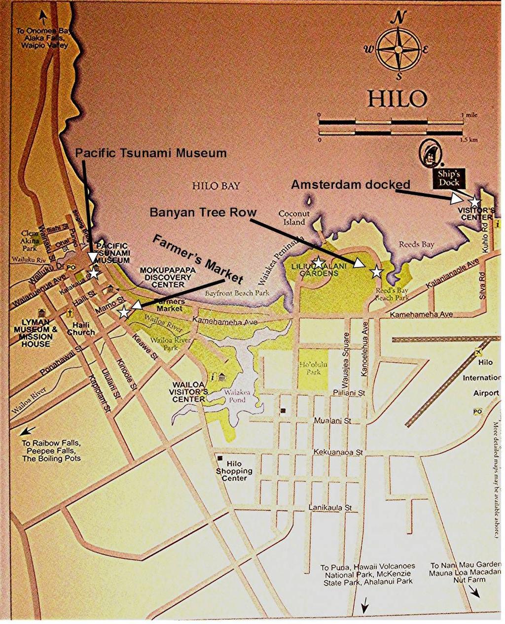
1 Day 63-Hilo, Hawaii-Banyans-Liliuokalani-Tsunami Museum-27 Nov 09: The day started with sky partly cloudy, calm sea and temperature in the mid 70s. We were entering the harbor at Hilo, Hawaii at about 7am. The maps below show where Hilo is located in the Hawaiian Island Chain and on the island of Hawaii. A street map of Hilo shows the places we visited in Hilo during our stay.
2


3 One of the first things that we noticed about Hilo Harbor is the long curved breakwater that has been built out into the sea, as shown in the photo below. Without the breakwater the ships in the harbor would have little protection from storms and the normal ocean swells. The Amsterdam proceeded on to the dock at Pier 1 and it was safely tied up by 8am. Shortly thereafter we were cleared by the authorities and could go ashore. The ship was located next to the cruise terminal building. In addition to the cruise terminal, Pier 1 contained a storage yard that was filled with parked semi trailer beds used to haul the large sea going cargo containers, as shown on the right. We wondered if this large yard of idle trailers was another sign of the worldwide economic downturn. We had been to Hilo several times in the past and seen the volcanoes and water falls so didn t have any tours scheduled. Our plan was to walk from the ship into Hilo and visit the Pacific Tsunami Museum in the morning. The Amsterdam was scheduled to leave port fairly early. All aboard was at 3:30 pm so we didn t have a lot of time to spend in Hilo. About 9:30 we left the Amsterdam and passed through the cruise terminal. It was threatening to rain so we wore our rain jackets and were comfortable. We walked off of Pier 1 and turned right on Kalanianaole Avenue towards downtown Hilo. We walked


4 down Kalanianaole Avenue and, as can be seen in the street map above, that took us by the Reed s Bay Beach Park and Liliuokalani Gardens. Soon after turning onto Kalanianaole Avenue we noticed a severely worn image of a pair of thongs on the sidewalk pointing us in the direction of downtown Hilo, as shown on the right. This was probably the clever idea of some Visitor Bureau project of a few years ago. At Reed s Bay Beach Park we turned right so that we could walk around the edge of the harbor in the direction of Liliuokalani Gardens. Shortly after turning toward the harbor we saw the Holland American ship, Zaandam, gliding past us on its way to a dock near the Amsterdam, as shown in the picture on the left. that it was lined with beautiful banyan trees as shown below. We had been unaware of what was on this road but we soon found


5 It appeared that back in the 1930s there must have been a civic project to plant the banyan trees and various people would sponsor the tree or dedicate it to the memory of another person. Now there were wooden plaques by most of the trees showing the name of the person associated with that tree. The pictures below show some of the plaques we saw as we walked along. The plaque by this tree on the left read, Dr. L.L. Doggegett July The plaque below for Dr. Poling was dated 1930, indicating the tree was planted nearly 80 years ago. That was the earliest date we saw on our walk. The plaque shown below was dedicated to Babe Ruth in Leo Carrillo was commemorated by the plaque on the right in Barbara remembered how this movie star of Western Films would often ride in San Diego County Fair parades in the 1950s and 1960s.


6 It was difficult to get good quality photos of the giant banyan trees but the pictures below give some notion of views that we had.


7 We passed by Uncle Billy s Fish & Steak House which was surrounded by palm and banyan trees. They were still advertising the Thanksgiving Buffet that they had yesterday. Next to Uncle Billy s Fish & Steak House was a large banyan tree, shown below, with a dedication plaque for Uncle Billy Kimi, June That tree got a late start compared with most of the others. We walked along the street lined with banyan trees and eventually came to the Liliuokalani Gardens.


8 The Liliuokalani Gardens presented a beautiful Japanese style landscape as shown in the picture on the right and below. While we walked along there were several van loads of Japanese tourists visiting the park, with guides describing the features. Later, at the Pacific Tsunami Museum we found out that this area was covered with businesses and homes in the 1940s but that was all destroyed in the tsunami of After the tsunami the people of Hilo turned the harbor area at risk of flooding into these gardens and other parks. Apparently the giant banyan trees we saw earlier were here at the time of the tsunami but were spared being uprooted and killed. The green park area along the Hilo harbor is one of the best examples we know of where a tragedy was turned into a positive result.

9 There was a light rain misting down onto us intermittently but we continued walking along the harbor towards downtown Hilo. We passed the Kamehameha Canoe Club with all the boats lined up along the beach and on the lawn. Finally we crossed Kamehameha Avenue and came to the Pacific Tsunami Museum as shown on the right. We bought tickets to the museum at $7 each for seniors and immediately joined a lecture that was being given about the tsunami phenomenon and in particular the disastrous tsunami that hit Hilo on April Fool s Day 1946 (4/1/46). A tsunami is a wave that travels through the ocean as the result of an earthquake that causes vertical movement of the earth s surface at the bottom of the ocean. The wave may be only a foot or so high as it travels across the miles of open ocean so it wouldn t be noticed by people on a ship. However, when the wave approached the shallow water of land it rises up and can be 10 or 20 feet high. These waves used to be called tidal waves because the water would rise and fall much like tidal action. However, the phenomenon has nothing to do with tidal forces so now it is called a tsunami which is the Japanese word for the effect. Hilo harbor is ideally positioned to catch a tsunami coming from the north. By reference to the map of the island of Hawaii above one can see that at the place where Hilo is located the shoreline of the island forms a cup with the opening facing north and the city of Hilo at the bottom of the cup. While tsunamis approaching from any direction are dangerous the ones coming from the north are the most destructive. Old Hilo was built with dense housing built right down to the water s edge along the harbor. On April 1, 1946 a tsunami approached Hilo from the Aleutian Islands. At first the water receded and the harbor was empty out to where the current breakwater, as shown earlier, is located. Fish were left flopping around on the mud and some people rushed out to gather them up. However, minutes later the water surged back in as the crest of the tsunami wave passed. The water surge wiped out the homes and businesses along the harbor for about 1000 feet back from the normal water s edge. In Hilo 96 people were killed and on the whole island of Hawaii 159 people were killed by the event.


10 There were also tsunami events in the Hilo harbor in 1952, 1957 and The 1946 and 1960 tsunamis were the most devastating. Barbara visited Hilo in 1960 and can remember seeing the wreckage from the 1960 tsunami. As a result of all this sad experience and the realization that tsunamis are inevitable, the people of Hilo designated the land along the harbor as a park area so that future tsunamis will not cause the economic and human life loss that was suffered in the past. In addition the international community has created the Pacific Tsunami Warning Center to provide ample warning. The Pacific Tsunami Museum has many exhibits documenting tsunami detection technology and the damage caused by tsunamis that have swept through the region, as shown above and below.


11 After about an hour of perusing the exhibits we left the Pacific Tsunami Museum much better informed about tsunamis than before. We proceeded up a slight grade into the part of Hilo that was not washed by previous tsunamis. The town looked a bit down at the heels as shown in the photo on the right. We returned to the harbor front area where businesses were rebuilt after the tsunamis. They were built back from the water along a line considered beyond the reach of typical tsunamis. Here is a photo of some of those business buildings below, from the viewpoint of the park area across the street.


12 The street here was Kamehameha Avenue, the main street of Hilo. One of the stores along the street sells fireplaces as their sign indicates. We thought that it would be a brave kind of entrepreneur who could survive selling fireplaces in a tropical place like Hilo. However, they have 30 years of experience to show it can be done. We found a gas station where regular unleaded gas was selling for $3.699 dollars per gallon, as shown on the right. Across the street we saw the perfect backdrop for Barbara s library card to verify the visit to Hilo, as shown on the below.


13 Crossing the street again we entered the Farmer s Market which was loaded with all kinds of fresh fruit, vegetables and flowers as shown below. We even found an old fashioned public pay telephone. These are getting hard to find in this day of the ubiquitous cell phone glued to every ear.

14 By this time it was early afternoon. The rain had stopped but with all-aboard scheduled for 3:30pm we decided to bring our visit of downtown Hilo to a close. We went by a bus stop where a lot of people were waiting for the free shuttle bus back to the ship. An enterprising young taxi van driver announced that we had a 45 minute wait for the next bus and he would shuttle us back to the ship for $2. That sounded like a bargain to us so we piled into the van for the ride back to Pier 1 and the Amsterdam. With some nostalgia we took the short walk back from the harbor gate to the Amsterdam. We had been taking these walks for the last two months and this was our last return to the ship before landing in Los Angeles and leaving for home in four days. In the photo on the right Barbara can be seen plodding back to the Amsterdam for the last time on this cruise. Back on board the Amsterdam we were able to get a photograph of the Zaandam as shown below. It has a profile similar to that of the Amsterdam except it has only one smoke stack.

15 The waves were kicking up out in the ocean and we could see them crashing over the Hilo Harbor breakwater as shown in this photo on the right. We wondered how rough the ride would be when we got underway later. The Amsterdam got underway at 4pm and we sailed out of the harbor past the entrance in the breakwater shown below. As it turned out the stabilizers did their job and the ride was just a gentle rocking when we hit the open waters.

16 After dinner we went to the last show of the Amsterdam Singers and Dancers for this cruise. We went to the show called Love Songs from Broadway, Costumes from Mackie where the stewards were serving Champagne while we waited before this closing show got underway. Before the opening scene, Bruce had all the players come out in front of the curtain for a Champagne toast and recognition by the audience for a job well done in entertainment for the last two months. The assembled cast is shown below with Cruise Director, Bruce, in the middle. The show was terrific as they all have been during the cruise. The Amsterdam continued cruising on a north easterly course at about 20 knots during the night. We have 4 days at sea and then the inevitable check-out day in Los Angeles.
Kalihiwai Region of Kauai
 Kalihiwai Region of Kauai Our Second Home overlooking the Ocean Jean and I have spent many months living in Kauai over the past few years, and we have learned a lot about this most distant outpost of America.
Day 22 American Samoa Pago Pago Tsunami Damage Tisa s Bar 17 Oct. 09:
 Day 22 American Samoa Pago Pago Tsunami Damage Tisa s Bar 17 Oct. 09: The day started with partly cloudy sky, calm sea and comfortable temperature. The Amsterdam was approaching Tutuila, the largest island
Day 30 Cairns, Australia Kurunda Scenic Railway Skyrail 26 Oct. 09
 Day 30 Cairns, Australia Kurunda Scenic Railway Skyrail 26 Oct. 09: The day started with bright sunshine and cloudless sky over Cairns, Australia. Two years ago when we visited Cairns it was a rainy dismal
Tsunamis. Tsunamis COMMUNITY EMERGENCY RESPONSE TEAM TSUNAMIS
 Tsunamis Tsunamis Tell the participants that tsunamis are ocean waves that are produced by underwater earthquakes or landslides. The word is Japanese and means harbor wave because of the devastating effects
Geology 15 Activity 5 A Tsunami
 Materials: Marigram recorded in San Diego, May 23, 1960. Travel Time Graph To San Diego. Answer sheet Source of information: Lander, James F., Patricia A. Lockridge and Michael J. Kozuch, s Affecting the
Hong Kong, China Day 28 Oct. 25:
 Hong Kong, China Day 28 Oct. 25: This was our second day in Hong Kong and we had no specific agenda. After breakfast we went into the Ocean Terminal building where there was free access to the Internet.
Waves. Swell, Surf, and Tides
 Waves Swell, Surf, and Tides Tsunamis Tsunamis Waves of Destruction Seismic Sea Waves Seismic Sea Waves Most tsunamis are generated by earthquakes Seismic Sea Waves Most tsunamis are generated by earthquakes
Welcome to Al Brooks Rose Bowl Tours
 Welcome to Al Brooks Rose Bowl Tours For over 70 years we've hosted thousands of guests at the Rose Parade and Rose Bowl Game. With an ever-growing list of satisfied customers, we re the most trusted name
Coastal management has lagged behind the growth in population leading to problems with pollution
 Fifty percent of the population of the industrialized world lives within 100 km of a coast. Coastal management has lagged behind the growth in population leading to problems with pollution and natural
Shanghai, China Day 23 Oct. 20:
 Shanghai, China Day 23 Oct. 20: This was our second day in Shanghai. The early morning sky was overcast with the threat of rain. We had no organized tours today. A couple days ago we had lost or misplaced
Geology 10 Activity 8 A Tsunami
 Geology 10 Activity 8 A Materials: Marigram recorded in San Diego, May 23, 1960. Travel Time Graph To San Diego. Answer sheet Source of information: Lander, James F., Patricia A. Lockridge and Michael
The Pillowcase Project Learn. Practice. Share.
 The Pillowcase Project Learn. Practice. Share. PART 6: LOCAL HAZARD SUPPLEMENT (10 MINUTES) Tsunami Preparedness Learning Objectives Students will be able to explain what causes tsunamis and what happens
Search the Sea. By Sadie Young
 Search the Sea By Sadie Young Table of Contents In and Out..1 A Tsunami and a Hurricane...2 The Moon and the Tide.3 Amazing Ocean Animals...4 Ocean Needs Help....5 Glossary.....6 1 In and Out Have you
LAB: WHERE S THE BEACH
 Name: LAB: WHERE S THE BEACH Introduction When you build a sandcastle on the beach, you don't expect it to last forever. You spread out your towel to sunbathe, but you know you can't stay in the same spot
Only launch your boat once you have a clear understanding of the most up-to-date weather forecast.
 Weather and Tides Observing the Weather Only launch your boat once you have a clear understanding of the most up-to-date weather forecast. Start with television and newspaper weather map reports; they
OCN 201 Tides. Tsunamis, Tides and other long waves
 OCN 201 Tides Tsunamis, Tides and other long waves Storm surges Caused by winds and low atmospheric pressure associated with large storms Can raise sea surface by up to 25 ft, bottom contours magnify effect
The Tsunami Quilt: Grandfather s Story
 The Tsunami Quilt: Grandfather s Story Author: Anthony D. Fredericks Illustrator: Tammy Yee Guide written by Cheryl Grinn Portions may be reproduced for use in the classroom with this express written consent
As we approached Raiatea in the early morning the entire island could be included in a single picture, as shown below.
 Day 18 Raiatea, Society Islands Mata s Tour - 13 Oct 09: The day started with a cloudy sky, low 80s temperature and a bit of humidity. We had spent the entire night slowly traveling the 25 distance between
COMMENTS FOR THE NSF TSUNAMI WORKSHOP AT HILO, HAWAII, DECEMBER 2006 By Robert L. Wiegel
 COMMENTS FOR THE NSF TSUNAMI WORKSHOP AT HILO, HAWAII, 26-28 DECEMBER 2006 By Robert L. Wiegel 1. Introduction 2. Risk, Adjustment, Mitigation 3. Hilo, Hawaii 4. Designing for Tsunamis: Seven Principles
M A R I N E C O R P S B A S E S H A W A I I C O M M U N I T Y B R I E F I N G O N T S U N A M I S 2 8 F E B
 M A R I N E C O R P S B A S E S H A W A I I C O M M U N I T Y B R I E F I N G O N T S U N A M I S 2 8 F E B 2 0 1 8 Briefer s JACQUELINE Rank FREELAND and Name INSTALLATION Briefer s PROTECTION Title/Office
DAY 1 DECEMBER 28, 15
 2015-16 Outback Bowl Performance Tour Sample Schedule DAY 1 DECEMBER 28, 15 ARRIVAL DAY Reception Desk Open. We will pass out your packets at that time. Registration Desk will be open all day. All rooms
Ile des Pins, New Caledonia Day 53 Nov. 19:
 Ile des Pins, New Caledonia Day 53 Nov. 19: We woke to a bright sunny morning with the Amsterdam moving slowly between small islands that slid by on each side of us. About 7am the ship dropped anchor near
FOR PERSONAL USE. Shoreline Erosion BROWARD COUNTY ELEMENTARY SCIENCE BENCHMARK PLAN ACTIVITY ASSESSMENT OPPORTUNITIES. Grade 4 Quarter 1 Activity 9
 activity 9 Shoreline Erosion BROWARD COUNTY ELEMENTARY SCIENCE BENCHMARK PLAN Grade 4 Quarter 1 Activity 9 SC.D.1.2.4 The student knows that the surface of the Earth is in a continuous state of change
3.9 FROM ISLANDS TO ATOLLS
 3.9 1 3.9 FROM ISLANDS TO ATOLLS OBJECTIVES The students Listen to a description of the formation of volcanic islands, fringing reefs, barrier reefs, and atolls. Observe and participate in a simulation
Intergovernmental Oceanographic Commission. International Tsunami Information Center
 W W W.T S U N A M I W AV E.I N F O Intergovernmental Oceanographic Commission INTERNATIONAL TSUNAMI INFORMATION CENTER International Tsunami Information Center United Nations Educational, Scientific and
Unit 11 Lesson 2 How Does Ocean Water Move? Copyright Houghton Mifflin Harcourt Publishing Company
 Unit 11 Lesson 2 How Does Ocean Water Move? Catch a Wave A wave is the up-and-down movement of surface water. Catch a Wave Catch a Wave (wave effects) Surface waves are caused by wind pushing against
The Movement of Ocean Water. Currents
 The Movement of Ocean Water Currents Ocean Current movement of ocean water that follows a regular pattern influenced by: weather Earth s rotation position of continents Surface current horizontal movement
WIND SPEED LENGTH OF TIME WIND BLOWS (Duration) DISTANCE OVER WHICH IT BLOWS (Fetch)
 DISTANCE OVER WHICH IT BLOWS (Fetch)") WAVES Up and down movement of ocean surface Transportation of energy across the water over vast distances If not stopped by anything, waves can travel entire oceans Size and speed depend upon: WIND SPEED
WAVES Up and down movement of ocean surface Transportation of energy across the water over vast distances If not stopped by anything, waves can travel entire oceans Size and speed depend upon: WIND SPEED
National Dam Safety Awareness Day and
 National Dam Safety Awareness Day and 125 th Anniversary Commemoration of May 31, 1889 Johnstown Flood Disaster May 31, 2014 Johnstown, PA Organized by the Johnstown Area Heritage Association (JAHA) in
March 15, 2017 Out of India Issue 3 from Rishikesh
 Rishikesh and the Ganges River a few kilometers up river from Sadhana Mandir. March 15, 2017 Out of India Issue 3 from Rishikesh do personal reflection as opposed to doing group meditation. Sadhana Mandir
Parking. Other Transportation GETTING HERE KONA INTERNATIONAL AIRPORT AT KEAHOLE - KOA. Visit KOA airport website Airport Phone:
 GETTING HERE KONA INTERNATIONAL AIRPORT AT KEAHOLE - KOA Visit KOA airport website Airport Phone: 1 808 327 9520 Hotel direction: 19.3 miles N Driving directions This hotel does not provide shuttle service.
Get to Know Your Schedule
 Get to Know Your Schedule It s going to be a busy and EXCITING week. Take some time and get familiar with the schedule below. As Cindy always says, Early is ON TIME and On Time is LATE. (Please Do Not
Traveling to Your Broughton Archipelago / Johnstone Strait Mothership KAYAKING Adventure
 Traveling to Your Broughton Archipelago / Johnstone Strait Mothership KAYAKING Adventure Important Points Columbia III will be moored at the CAB Fuel Dock in Port McNeill (250) 956-4044 or 956-3336. www.mothershipadventures.com/maps/port_mcneill_bc_map.htm
Intergovernmental Oceanographic Commission
 Intergovernmental Oceanographic Commission International Tsunami Information Centre Intergovernmental Oceanographic Commission (IOC) United Nations Educational, Scientifi c and Cultural Organization (UNESCO)
Natural Bridges Field Trip Activity
 Natural Bridges Field Trip Activity This is due in class on MONDAY- March 1 - not in sections! Name TA: NOTE ON THE GRADING OF THIS ASSIGNMENT: Many of the questions below (especially in the tidepool part)
Teen Camps in beautiful Southern California
 Escuela-Ref. JE.U4- San Diego - Programa en familia Teen Camps in beautiful Southern California School Our school is situated in the heart of downtown San Diego, where you can enjoy a variety of activities,
Coastal Hazards Study
 Coastal Hazards Study 2212 Beach Boulevard, Pacifica Prepared for: EXECUTIVE SUMMARY City of Pacifica 170 Santa Maria Ave Pacifica, CA 94044 Prepared by: moffatt & nichol 2185 N. California Blvd. Walnut
Name Class Date. Use the terms from the following list to complete the sentences below. Each term may be used only once. Some terms may not be used.
 Assessment Chapter Test B The Movement of Ocean Water USING KEY TERMS Use the terms from the following list to complete the sentences below. Each term may be used only once. Some terms may not be used.
Open Pacific Coast Study. California Coastal Analysis and Mapping Project
 Open Pacific Coast Study California Coastal Analysis and Mapping Project September 2012 California Open Coast Counties California Coastal Analysis and Mapping Project This publication is an initiative
What are Waves? Earthquake. Waving flags. Vocal Cords Vibrate
 Waves Ch. 10 What are Waves? All waves are movement of energy through a medium (air, rock, water) Series of vibrations or undulations in a medium Wave types: ocean, sound, light, seismic Vocal Cords Vibrate
Redondo Beach Boat Launch Ramp Facility
 Redondo Beach Boat Launch Ramp Facility Feasibility Report for the California Department of Boating and Waterways 2015 Grant Cycle For the City of Redondo Beach Submitted by March 13, 2014 Table of Contents
Oceans - Laboratory 12
 Oceans - Laboratory 12 (Name) How do ocean waves form? All waves are disturbances of a fluid medium through which energy is moved (Davis, 1997). Ocean waves travel on the interface between oceans and the
4/20/17. #32 - Coastal Erosion Case Histories - Lake Michigan
 Writing Assignment Due Monday by 11:59 pm #32 - Coastal Erosion Case Histories - Lake Michigan See main class web pages for detailed instructions Submit papers Illinois Compass No copying: Compass will
Earth Explore. Adventures. Big Island. of Hawaii. 8-Days of Discovery in Paradise
 Earth Explore Adventures 8-Days of Discovery in Paradise Your chance to discover the hidden wonders. Explore a place of intoxicating beauty, where and the primal forces of nature, co-exist with the harmony
COASTAL ENVIRONMENTS. 454 lecture 12
 COASTAL ENVIRONMENTS Repeated movement of sediment & water constructs a beach profile reflecting the balance between average daily or seasonal wave forces and resistance of landmass to wave action Coasts
Page 1 of 6 WINTER 2007
 Page 1 of 6 WINTER 2007 LETTER FROM THE PRESIDENT - Al Rae There is certainly a lot going on in South Bethany this winter; of course the biggest event is the beach replenishment which is now well underway.
Saturday, December 4 6:00 PM, East Basin theme Peace on Earth
 48 th Annual LA Harbor Holiday Afloat Saturday, December 4 6:00 PM, East Basin theme Peace on Earth Grand Marshal USCG Captain Roger Laferriere Viewing locations: Banning s Landing, Wilmington Marinas,
KAHULUI, HAWAII N, W. maui SUMMER 2019
 KAHULUI, HAWAII 20.8893 N, 156.4729 W maui trip overview The island of Maui is an adventure paradise for those who heed the call of the aquatic. On this adventure in Maui we take you from the dense green
Pacific Coast Congress of Harbor Master & Port Managers
 Pacific Coast Congress of Harbor Master & Port Managers Getting It Done The Crescent City Harbor has a long history of damage and destruc7on from tsunamis. The city experienced tsunami condi7ons 31 7mes
Short Story: 'The Open Boat' by Stephen Crane (Part 1)
") 12 May 2012 MP3 at voaspecialenglish.com Short Story: 'The Open Boat' by Stephen Crane (Part 1) Library of Congress Stephen Crane BARBARA KLEIN: Now, the VOA Special English program AMERICAN STORIES. Our
12 May 2012 MP3 at voaspecialenglish.com Short Story: 'The Open Boat' by Stephen Crane (Part 1) Library of Congress Stephen Crane BARBARA KLEIN: Now, the VOA Special English program AMERICAN STORIES. Our
Rufus Janvier Jan Briscoe Photograph Collection. No online items
 http://oac.cdlib.org/findaid/ark:/13030/c8280ds5 No online items Paul Wormser Sherman Library and Gardens 614 Dahlia Ave. Corona del Mar, California 92625 (949) 673-1880 library@slgardens.org http://www.slgardens.org/
Intergovernmental Oceanographic Commission. International Tsunami Information Centre
 Intergovernmental Oceanographic Commission International Tsunami Information Centre Intergovernmental Oceanographic Commission (IOC) United Nations Educational, Scientific and Cultural Organization (UNESCO)
Directed Reading. Section: Ocean Currents. a(n). FACTORS THAT AFFECT SURFACE CURRENTS
. FACTORS THAT AFFECT SURFACE CURRENTS") Skills Worksheet Directed Reading Section: Ocean Currents 1. A horizontal movement of water in a well-defined pattern is called a(n). 2. What are two ways that oceanographers identify ocean currents? 3.
Skills Worksheet Directed Reading Section: Ocean Currents 1. A horizontal movement of water in a well-defined pattern is called a(n). 2. What are two ways that oceanographers identify ocean currents? 3.
Ventura County. Open Pacific Coast Study. California Coastal Analysis and Mapping Project
 Ventura County Open Pacific Coast Study California Coastal Analysis and Mapping Project December 2011 Project Name: Meeting: Date and Time: Location: California Coastal Analysis and Mapping Project (CCAMP)/Open
Netherlands South Holland Bike and Barge Tour 2019 Individual Self-guided 8 days / 7 nights
 Netherlands South Holland Bike and Barge Tour 2019 Individual Self-guided 8 days / 7 nights You are travelling through the green heart of the Netherlands by bike and boat. Hardly any province is more changing
Coastal Engineering Prof. V. Sundar Department of Ocean Engineering Indian Institute of Technology, Madras. Module - 9 Tsunami Lecture - 1 Tsunami - I
 Coastal Engineering Prof. V. Sundar Department of Ocean Engineering Indian Institute of Technology, Madras Module - 9 Tsunami Lecture - 1 Tsunami - I Now, we will get into one of the most important topic,
Summer camp in beautiful Southern California
 Summer camp in beautiful Southern California School Our school is situated in the heart of Downtown. You can enjoy a variety of activities including sports, shopping, dining and art in what is known as
Sebastian Cermeno ( )
") Sebastian Cermeno (1560-1602) Sebastian Rodriguez Cermeno was a Portuguese adventurer who explored the coast of California for Spain. He was a skilled navigator and had lots of experience sailing across
Sebastian Cermeno (1560-1602) Sebastian Rodriguez Cermeno was a Portuguese adventurer who explored the coast of California for Spain. He was a skilled navigator and had lots of experience sailing across
Chicago River. My Chicago. Vocabulary INSTRUCTOR NOTE
 Chicago River 5 INSTRUCTOR NOTE Ask students to locate the blue stripes on their Chicago flag. The stripes represent Lake Michigan and the north and south branches of the Chicago River. The Chicago River
DAY TWO - HONOLULU. by Rick Cotton
 DAY TWO - HONOLULU by Rick Cotton Eight loooooong hours later, we come down out of the clouds into Honolulu right over a Navy task force at sea, two large helicopter carriers and a couple of destroyers
The following resources were used in writing the texts:
 Lesson Plans CANADA Vancouver, Canada s West Coast City (Level 2) The purpose of LessonPlansCanada is to provide well-structured and interesting reading texts and other classroom activities. These lesson
The Pillowcase Project Learn. Practice. Share.
 The Pillowcase Project Learn. Practice. Share. local hazard resource Tsunami Preparedness Learning Objectives Students will be able to explain what causes tsunamis and what happens during a tsunami. Students
Wacky Weather SCIENCE FACT #1. What is the difference in Weather and Climate?
 Wacky Weather Sitting on the dock at her beach house, Angelica noticed how beautiful the waves were as they rushed into shore. She could not believe how cool it was on the beach. The day had been very
Understanding the Tsunami Wave
 The First Tsunami attack on Sri Lanka Krakatoa Island 27 th August 1883 Understanding the Tsunami Wave Generation Propagation Nearshore Transformation Shoreline Entry Inland Dissipation 1 Generation and
Hawaiian Islands. Thursday, March 30 Tuesday, April 11, 2017 Thursday, June 29 Tuesday, July 11, 2017 Thursday, November 2 Tuesday, November 14, 2017
 Hawaiian Islands Discover the tropical beauty of Hawaii during this magnificent vacation, and enjoy pure tropical bliss as you island hop from Oahu to Hawaii and Kauai to Maui. Whether you re admiring
Ocean Waves. Capillary. Gravity. Wind generated. Tides Tsunamis Seiches
 Ocean Waves Capillary Wind generated Gravity Tides Tsunamis Seiches Capillary waves are driven by the surface tension produced by electrically polarized water molecule San Pedro Lighthouse Waves are alternate
New Zealand. Day 1. Meeting the ship in the morning. Ben Riccini Page 1
 New Zealand Day 1 I arrived at the Spirit of the New Zealand in the early morning with Karl who I had shared a hotel room with the night before. Whilst we were waiting for the previous voyage to leave
S/V Montauk Light: Lagos, Portugal St Thomas 8 Nov 6 Dec ,200 nm
 S/V Montauk Light: Lagos, Portugal St Thomas 8 Nov 6 Dec 2014 3,200 nm Departed Lagos, Portugal 8 Nov Arrived Funchal, Madeira 12 Nov: Good stop after wet, cool run south Arrived St Martin for fuel 5 Dec
UNIVERSITY OF HAWAII LlBRA~Y. A Self-Guided Automobile Tour. Hilo Bay Shoreline. & OnoDlea Bay
 UNIVERSITY OF HAWAII LlBRA~Y A Self-Guided Automobile Tour Hilo Bay Shoreline & OnoDlea Bay { THE HllO AUTO - GUIDE A Silf-Iutdid Automoblll Tour of H 11 0 Bay Shore 11 ne and Onomea Bay Written by RITA
Notice of Race Friday, August 15, 2014
 Morro Bay Yacht Club and Zongo All-Stars present: 6 th ANNUAL ZONGO YACHTING CUP! Notice of Race Friday, August 15, 2014 Boating race / cruise from Morro Bay to Avila Beach, CA Classes: PHRF (So Cal.),
OCEANOGRAPHY STUDY GUIDE
 OCEANOGRAPHY STUDY GUIDE Chapter 2 Section 1 1. Most abundant salt in ocean. Sodium chloride; NaCl 2. Amount of Earth covered by Water 71% 3. Four oceans: What are they? Atlantic, Pacific, Arctic, Indian
The LA/LB Harbors handle more than 5,500 commercial vessel arrivals per year (excluding local coastwise and Catalina Island traffic).
.") X. SMALL CRAFT For the purpose of the Los Angeles and Long Beach Harbor Safety Plan, pleasure vessels, commercial fishing vessels and sportfishing boats are designated as small craft. A. BACKGROUND: The
X. SMALL CRAFT For the purpose of the Los Angeles and Long Beach Harbor Safety Plan, pleasure vessels, commercial fishing vessels and sportfishing boats are designated as small craft. A. BACKGROUND: The
Tournament of Roses Parade
 featuring the Queen Mary and Gala New Year s Eve Party 5 Days 6 Meals See the Tournament of Roses Parade the Granddaddy of all Parades from your reserved seats right on Colorado Boulevard. 2016 Departure
the little boy 1 a good boy 1 then you give 1 is about me 1 was to come 1 old and new 1 that old man 1 what we know 1 not up here 1 in and out 1
 the little boy 1 a good boy 1 is about me 1 then you give 1 was to come 1 old and new 1 what we know 1 that old man 1 in and out 1 not up here 1 good for you 1 down at work 1 with his cat 1 it was new
Waves. Unit 14. Why are waves so important? In this Unit, you will learn: Key words. Previously PHYSICS 305
 Previously From Page 288 Sound waves travel through the air from a vibrating source. From Page 294 Light can travel through empty space. Unit 14 Waves Why are waves so important? We can use the idea of
Our Council s Own: Oceanography Cadette/Senior/Ambassador Badge
 Our Council s Own: Oceanography Cadette/Senior/Ambassador Badge Oceanography: The science that deals with oceans, the delimitation of their extent and depth, the physics and chemistry of their water, marine
President's Message...
 From: Subject: Date: To: Hawaii Island Palm Society palmguysd@gmail.com Hawaii Island Palm Society Newsletter June 15, 2018 at 10:14 AM Tim Brian begteb@hawaii.rr.com Hawai'i Island Palm Society News-
RLRC COMMUNITIES EAST GRAND FORKS AREA CHARACTER THE RED LAKE RIVER & THE RED RIVER OF THE NORTH CONFLUENCE EAGLE POINT BOAT LAUNCH DESIGN
 AREA CHARACTER THE RED LAKE RIVER & THE RED RIVER OF THE NORTH CONFLUENCE EAGLE POINT BOAT LAUNCH DESIGN DESIGN DETAILS 135 AREA CHARACTER East Grand Forks a city of 7,501 people is located across the
Texas passes, longshore transport, hurricanes, beach erosion and sea level
 Texas passes, longshore transport, hurricanes, beach erosion and sea level Richard L. Watson, Ph.D. (361) 749-4152 Field work can be strange! 120,000 years of sea level Years each zone exposed above S/L
Maps The maps provided are a guide and are not to scale. Please use OS Explorer Map 120 (Chichester).
.") A Walker s Guide - Chichester Harbour Useful Information Directions All the walks were tested in 201. Please note, however, that some footpaths may be diverted and buildings such as pubs may have changed
A Walker s Guide - Chichester Harbour Useful Information Directions All the walks were tested in 201. Please note, however, that some footpaths may be diverted and buildings such as pubs may have changed
The Dhow of Racing. Written and photographed by Jeff Harris
 The Dhow of Racing Written and photographed by Jeff Harris What a sight! The racing dhow Sirdal outpaces four running mates as they all head for the finish line. The Sirdal s mainsail is almost perfectly
THE RESTLESS SEA. https://pao.cnmoc.navy.mil/pao/educate/oceantalk2/indexrestless.htm
 THE RESTLESS SEA Energy from the sun is the engine that drives the major ocean basin circulation patterns. Rising warm air, sinking cold air, and uneven heating of the Earth's surface create wind, the
Puducherry Port Disaster. A Man-Made Made Tsunami. Coastal Erosion at Puducherry. & neighboring beaches of Tamil Nadu
 Puducherry Port Disaster A Man-Made Made Tsunami Coastal Erosion at Puducherry & neighboring beaches of Tamil Nadu Pondicherry Citizens Action Network February 2007 Once upon a time Pondicherry had a beautiful
Alaska - Day 3: Ketchikan (Day 2 was at sea)
") Alaska - Day 3: Ketchikan (Day 2 was at sea) Arrival in Port of Ketchikan. Two views. Disembarking for a day of exploring Ketchikan and taking excursions. View of Star Princess cruise ship from shore.
Alaska - Day 3: Ketchikan (Day 2 was at sea) Arrival in Port of Ketchikan. Two views. Disembarking for a day of exploring Ketchikan and taking excursions. View of Star Princess cruise ship from shore.
Chapter 22, Section 1 - Ocean Currents. Section Objectives
 Chapter 22, Section 1 - Ocean Currents Section Objectives Intro Surface Currents Factors Affecting Ocean Currents Global Wind Belts (you should draw and label a diagram of the global wind belts) The Coriolis
Junior Leader s Packet
 Junior Leader s Packet Tours, Times, and Costs Locust Grove is open on Monday Saturday from 10:00 to 4:30 and on Sundays from 1:00 to 4:30. At the beginning of the tour, there is an optional 15 minute
4754(B)/01 MATHEMATICS (MEI) ADVANCED GCE UNIT. Applications of Advanced Mathematics (C4) Paper B: Comprehension INSERT THURSDAY 14 JUNE 2007 PMT
/01 MATHEMATICS (MEI) ADVANCED GCE UNIT. Applications of Advanced Mathematics (C4) Paper B: Comprehension INSERT THURSDAY 14 JUNE 2007 PMT") ADVANCED GCE UNIT MATHEMATICS (MEI) Applications of Advanced Mathematics (C4) Paper B: Comprehension INSERT THURSDAY 14 JUNE 2007 4754(B)/01 Afternoon Time: Up to 1 hour INSTRUCTIONS TO CANDIDATES This
ADVANCED GCE UNIT MATHEMATICS (MEI) Applications of Advanced Mathematics (C4) Paper B: Comprehension INSERT THURSDAY 14 JUNE 2007 4754(B)/01 Afternoon Time: Up to 1 hour INSTRUCTIONS TO CANDIDATES This
Chapter - Oceans and Coasts
 Chapter - Oceans and Coasts Discussion: What do oceans contribute to the environment of Earth? How do Earth s major systems relate to the oceans? Oceans and Coasts Oceans are important - Thermal regulation
Going to Hawaii: Let Us Share What We Love. Lodging: Dining:
 Going to Hawaii: Let Us Share What We Love Nancy and I have been to Hawaii at least 20 times. We keep coming back because we love the people and culture in addition to the great weather, beaches and golf.
Overview. Beach Features. Coastal Regions. Other Beach Profile Features. CHAPTER 10 The Coast: Beaches and Shoreline Processes.
 Overview CHAPTER 10 The Coast: Beaches and Shoreline Processes Coastal regions constantly change. The beach is a dominant coastal feature. Wave activity continually modifies the beach and coastal areas.
Here s a lovely old wooden schooner we saw in the anchorage.
 In May we took a brief timeout and returned to Atlanta. It was time for our annual doctors visits, dental appointments, etc. However, the most important reason was to attend our son s graduation! Luke
THE KIZUNA (BOND) PROJECT: JAPAN- FEDERATED STATES OF MICRONESIA (FSM)
 PROJECT: JAPAN- FEDERATED STATES OF MICRONESIA (FSM)") THE KIZUNA (BOND) PROJECT: JAPAN- FEDERATED STATES OF MICRONESIA (FSM) MAYBELLINE MARI IHARA SEPTEMBER 2012 Page 1 of 10 My Report on the Kizuna (Bond) Project I applied for this program, not knowing what
THE KIZUNA (BOND) PROJECT: JAPAN- FEDERATED STATES OF MICRONESIA (FSM) MAYBELLINE MARI IHARA SEPTEMBER 2012 Page 1 of 10 My Report on the Kizuna (Bond) Project I applied for this program, not knowing what
Gymnastique Magique DISNEY PERFORMING ARTS PRE PARADE FORM G (Revised Feb 2018)
") Gymnastique Magique DISNEY PERFORMING ARTS PRE PARADE FORM G (Revised Feb 2018) An exciting aspect of the Gymnastique Magique event is the opportunity for dancers to potentially participate in a pre-parade
Gymnastique Magique DISNEY PERFORMING ARTS PRE PARADE FORM G (Revised Feb 2018) An exciting aspect of the Gymnastique Magique event is the opportunity for dancers to potentially participate in a pre-parade
ISUILS 9 International Symposium Ultrafast Intense Laser Science -TRAVEL INFORMATION-
 ISUILS 9 International Symposium Ultrafast Intense Laser Science -TRAVEL INFORMATION- -Venue/Hotel Information- Hyatt Regency Maui Resort & Spa 200 Nohea Kai Drive, Lahaina, Hawaii, USA 96761-1985 Tel:
WHAT IS A TSUNAMI? happens.nz. Long or Strong GET GONE TSUNAMI 101
 WHAT IS A TSUNAMI? A tsunami is a series of powerful waves with strong currents. They are mostly caused by underwater or coastal earthquakes, and sometimes by underwater landslides or volcanic eruptions.
Storm Preparedness Plan for Manchester, Massachusetts Issued by the Manchester Harbormaster Department. A.
 Manchester-by-the-Sea Harbormaster Harbormaster 10 CENTRAL ST. MANCHESTER, MASSACHUSETTS 01944-1399 OFFICE (978)526-7832 CELL (978)473-2520 FAX (978)526-2001 HARBORMASTER@MANCHESTER.MA.US. Storm Preparedness
The frequently asked questions are grouped under headings to make it easier to find information -
 Tsunami Inundation Mapping for Hawke s Bay Frequently Asked Questions The frequently asked questions are grouped under headings to make it easier to find information - General tsunami information Tsunami
If you have a badge logo I d center it to this text. Douglas F. Jackson. Fire Chief / Emergency Management Director East Haven, CT
 If you have a badge logo I d center it to this text Douglas F. Jackson Fire Chief / Emergency Management Director East Haven, CT Experience 9YEARS Experience as Fire Chief Emergency Management Director
CHAPTER 2 HILO HARBOR TSUNAMI MODEL - REFLECTED WAVES SUPEKIMPOSED
 CHAPTER 2 HILO HARBOR TSUNAMI MODEL - REFLECTED WAVES SUPEKIMPOSED Robert Q. Palmer Michael E. Mulvihill Gerald T. Funasaki U. S. Amyr Engineer District, Honolulu Corps of &igineers, Honolulu, Hawaii ABSTRACT
EARTH SCIENCE 5.9 (WIND) WEATHER
 WEATHER") EARTH SCIENCE 5.9 (WIND) WEATHER Video Notes Key Points: 1. According to the video, what two factors cause wind: a. b. 2. Fill in the blanks from this quote from the video: Energy from the Sun heats the,
EARTH SCIENCE 5.9 (WIND) WEATHER Video Notes Key Points: 1. According to the video, what two factors cause wind: a. b. 2. Fill in the blanks from this quote from the video: Energy from the Sun heats the,