Pacific Coast Congress of Harbor Master & Port Managers
|
|
|
- Britney Harrell
- 5 years ago
- Views:
Transcription


1 Pacific Coast Congress of Harbor Master & Port Managers
2 Getting It Done The Crescent City Harbor has a long history of damage and destruc7on from tsunamis. The city experienced tsunami condi7ons 31 7mes between 1933 and 2008 In 1964, 12 people were killed and 19 blocks of the downtown area was destroyed. Today we ll discuss how the harbor recovered from the 2006 and 2011 tsunamis Presenters: Ellen Johnck, Ellen Johnck Consul7ng Patrick Bailey, Crescent City Harbor District Board of Harbor Commissioners Charlie Helms, CEO/Harbormaster, Crescent City Harbor District Anita Yao, Wharfinger, Port of San Francisco
3 The 2006 Round of Destruction started on November 15

4
5 2006 Tsunami The 2006 tsunami damaged the harbor but the true severity of the damages were discovered over a period of months The original damage es7mate did not qualify the event for Federal Assistance The Harbor District had to find a way to raise $5 million dollars to cover it s share of the rebuild CAL Office of Emergency Services did not want to upgrade the harbor their goal was to put it back the way it was They would pay for a limited amount of hazard mi7ga7on up to 15% of project cost However CAL OES would pay for upgrades required by codes and standards

6
7 The question was What are the Codes and Standards for Marina design in a tsunami zone? There were no standards for tsunamis in 2006 but there were guidelines for Hurricanes The design return period on hurricanes should be balanced against the expected life of the marina, and compliance with local codes and ordinances. Keep in mind that codes are minimum design criteria and increased strength and reliability may be more economical in the long run The answer: NONE! The recommended design period for hurricanes (wind and 7dal surge) is normally 50 years (2% probability, in any given year) and 25 years (4% probability in any given year) should be considered the absolute minimum design period. This is true even if the expected life of the offshore facili7es is less than 25 years.
8
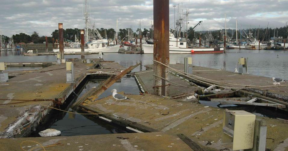
9 Ben C. Gerwick / COWI Tsunami Study The Harbor District, in an effort to support it s asser7on that the most efficient way to rebuild the harbor was to use the 50 year Hurricane standard, hired the Ben C. Gerwick engineering group, now a part of the COWI organiza7on, to construct a predic7ve model for tsunami flow into the Crescent City Harbor The Harbor wanted evidence that it could use to convince the CAL Office of Emergency Services (CAL OES) that rebuilding the harbor to a fify year return standard would actually be more cost efficient than just reconstruc7ng the marina to its prior state

10

11

12
13 Ben C. Gerwick/COWI Study Results The previous slides show the predicted flow and velocity of a tsunami similar to the 2006 tsunami in the Crescent City Harbor Flows of over 6 meters per second (11.6 knots or 13.4 miles per hour) are predicted along the seawall at the mouth of the harbor The high velocity flow con7nues into the harbor itself and brings its full force onto H dock and con7nues to baier G and F with similar force The destruc7ve then flows throughout the harbor in a generally clockwise flow at reduced veloci7es
14 Ben C. Gerwick/COWI Code Findings Bri=sh Code(BS :2000): Normally a design working life of the order of 50 years is expected Australian Code (as ): "Strength limit-state loads should be calculated for a 1 in a 50 year return period for wind, wave, surge and flooding loads EM ( ): "The economic design life of most small boat projects is 50 years" European Code (R46): For "port installa7ons for ( ) industrial opera7ons ( ) only 25 years [design service life] can be figured on"
15 2006 to 2011 The Harbor District was able to secure a Community Development Block Grant (CDBG) for $5 million which was used to cover the harbor s 25% cost obliga7on for its share of the 2006 tsunami repairs The grant was awarded to the Harbor so that the District could demonstrate the economic impact the fishing fleet and associated businesses had on the county In the mean7me, the Harbor District through its District Engineer, Stover Engineering, filed for the permits needed to begin the harbor rebuild Stover Engineering managed the design and permiqng process The permits pathway conformed to the CAL OES standard of rebuilding the harbor to its former condi7on

16 The Harbor s reconstruction permit was issued in late February 2011 just a few weeks before the Harbor was completely destroyed S7lls taken from USCG video filmed during the tsunami event

17 The flow pattern of the 2011 tsunami was an amazing match to what was predicted in the Ben C. Gerwick/ COWI Study S7lls taken from USCG videos filmed during the tsunami event

18 Following the 2011 tsunami devastation, the California Coastal Commission put the rebuild debate to rest by mandating that a fifty year tsunami resistant harbor be constructed


19 To meet the fifty year standard, pilings were upgraded from 16 inch diameter to 31 inch diameter pilings which were driven into bedrock


20 The Bellingham Marine Unibolt concrete dock system was selected for the new harbor

21 After dredging operations were completed in the Inner Boat Basin, the Outer Boat Basin and the federal channel were dredged while the Inner Harbor was being reconstructed

22 Surge suppression dock at Harbor entrance (Photo courtesy of Bellingham Marine)

23 View of Inner Boat Basin Piling Frequency (Photo courtesy of Bellingham Marine)

24 View facing H Dock (Photo courtesy of Bellingham Marine)

25 The West Coast s First Fifty Year Tsunami Resistant Harbor The Crescent City Harbor District (Photo courtesy of Bellingham Marine)
Tsunamis. Tsunamis COMMUNITY EMERGENCY RESPONSE TEAM TSUNAMIS
 Tsunamis Tsunamis Tell the participants that tsunamis are ocean waves that are produced by underwater earthquakes or landslides. The word is Japanese and means harbor wave because of the devastating effects
Controlling Coastal erosion
 Controlling Coastal erosion Coastal Erosion Rates in the U.S. Coastal Erosion and Stabilization Economic pressures demanding the stabilization of beaches and coastlines are immense Coastal Erosion and
Tsunami Preparedness in the Capital Region
 Tsunami Preparedness in the Capital Region A presentation by: the CRD Local Government Emergency Program Advisory Commission (LG EPAC) and your community emergency programs What is a tsunami? A tsunami
Geology 15 Activity 5 A Tsunami
 Materials: Marigram recorded in San Diego, May 23, 1960. Travel Time Graph To San Diego. Answer sheet Source of information: Lander, James F., Patricia A. Lockridge and Michael J. Kozuch, s Affecting the
Tsunami Preparedness in the Capital Region
 Tsunami Preparedness in the Capital Region A presentation by: the CRD Local Government Emergency Program Advisory Commission (LG EPAC) and your community emergency programs What is a tsunami? A tsunami
ST. LOUIS SECTION PROJECT OF THE YEAR AWARD
 ST. LOUIS SECTION PROJECT OF THE YEAR AWARD Originality and Innovation The St. Louis Harbor Project is located in the Upper Mississippi River between the entrance to the Chain of Rocks Canal at River
New Orleans Municipal Yacht Harbor
 New Orleans Municipal Yacht Harbor Marina Schematic Design Update 601 Poydras St., Suite 1860 New Orleans, LA, 70130 504-648-3560 Post-Katrina Municipal Yacht Harbor: Introduction The MYH was an approximate
Redondo Beach Boat Launch Ramp Facility
 Redondo Beach Boat Launch Ramp Facility Feasibility Report for the California Department of Boating and Waterways 2015 Grant Cycle For the City of Redondo Beach Submitted by March 13, 2014 Table of Contents
Geology 10 Activity 8 A Tsunami
 Geology 10 Activity 8 A Materials: Marigram recorded in San Diego, May 23, 1960. Travel Time Graph To San Diego. Answer sheet Source of information: Lander, James F., Patricia A. Lockridge and Michael
Fortified For Safer Living
 Fortified For Safer Living Module 15: Protecting Homes Against Floods and Storm Surge An important part of trying to reduce the damage and losses from storm events is to make sure that the home doesn t
HARBOR INFRASTRUCTURE INVENTORIES Oak Orchard Harbor, New York
 HARBOR INFRASTRUCTURE INVENTORIES Oak Orchard Harbor, New York Harbor Location: Oak Orchard Harbor is located on the southern shore of Lake Ontario at the mouth of Oak Orchard Creek in the village of Point
LAB: WHERE S THE BEACH
 Name: LAB: WHERE S THE BEACH Introduction When you build a sandcastle on the beach, you don't expect it to last forever. You spread out your towel to sunbathe, but you know you can't stay in the same spot
1-32 NOME HARBOR, ALASKA (CWIS NOS , 87755, & 10422) Condition of Improvement 30 September 2009
 Condition of Improvement 30 September 2009") NOME HARBOR 1-32 NOME HARBOR, ALASKA (CWIS NOS. 72742, 87755, & 10422) Condition of Improvement 30 September 2009 AUTHORIZATION: (1) Rivers and Harbors Act, 8 August 1917 (House Doc. 1932, 64th Congress,
NOME HARBOR 1-32 NOME HARBOR, ALASKA (CWIS NOS. 72742, 87755, & 10422) Condition of Improvement 30 September 2009 AUTHORIZATION: (1) Rivers and Harbors Act, 8 August 1917 (House Doc. 1932, 64th Congress,
Humboldt Bay s Harbor
 Humboldt Bay s Harbor Humboldt Bay is the second largest natural bay in California The only deep water harbor along ~400 miles of coast between San Francisco, CA and Coos Bay, OR One of only 11 deep water
1-32 NOME HARBOR, ALASKA (CWIS NOS , 87755, 12270, & 10422) Condition of Improvement 30 September 2012
 Condition of Improvement 30 September 2012") NOME HARBOR 1-32 NOME HARBOR, ALASKA (CWIS NOS. 72742, 87755, 12270, & 10422) Condition of Improvement 30 September 2012 AUTHORIZATION: (1) Rivers and Harbors Act, 8 August 1917 (House Doc. 1932, 64th
NOME HARBOR 1-32 NOME HARBOR, ALASKA (CWIS NOS. 72742, 87755, 12270, & 10422) Condition of Improvement 30 September 2012 AUTHORIZATION: (1) Rivers and Harbors Act, 8 August 1917 (House Doc. 1932, 64th
Puducherry Port Disaster. A Man-Made Made Tsunami. Coastal Erosion at Puducherry. & neighboring beaches of Tamil Nadu
 Puducherry Port Disaster A Man-Made Made Tsunami Coastal Erosion at Puducherry & neighboring beaches of Tamil Nadu Pondicherry Citizens Action Network February 2007 Once upon a time Pondicherry had a beautiful
El Niño Southern Oscillation. Pressure systems over Darwin Australia and Tahiti Oscillate Typically occurs every 4-7 years
 El Niño Southern Oscillation Pressure systems over Darwin Australia and Tahiti Oscillate Typically occurs every 4-7 years 1 2 What is it? Normal Conditions... What is it? During El Niño. 3 Local Effects
HARBOR INFRASTRUCTURE INVENTORIES Marquette Harbor, Michigan
 HARBOR INFRASTRUCTURE INVENTORIES Marquette Harbor, Michigan Harbor Location: Marquette Harbor is located in Marquette Bay on the south shore of Lake Superior, 160 miles west of Sault Ste. Marie, MI and
COMMENTS FOR THE NSF TSUNAMI WORKSHOP AT HILO, HAWAII, DECEMBER 2006 By Robert L. Wiegel
 COMMENTS FOR THE NSF TSUNAMI WORKSHOP AT HILO, HAWAII, 26-28 DECEMBER 2006 By Robert L. Wiegel 1. Introduction 2. Risk, Adjustment, Mitigation 3. Hilo, Hawaii 4. Designing for Tsunamis: Seven Principles
Coastal Engineering Technical Note
 Coastal Engineering Technical Note BAFFLED BREAKWATER FOR LIMITED FETCH SITES CETN III-45.(12/91) PURPOSE: To describe the Spud Point Marina breakwater, an innovative baffledtype breakwater designed to
The Failure of the Kamaishi Tsunami Protection Breakwater
 PT-13: Coastal and Ocean Engineering ENGI.8751 Undergraduate Student Forum Faculty of Engineering and Applied Science, Memorial University, St. John s, NL, Canada March, 2013 Paper Code. (PT-13 - Tucker)
4/20/17. #31 - Coastal Erosion. Coastal Erosion - Overview
 Writing Assignment Due Monday by 11:59 pm #31 - Coastal Erosion Beach front property! Great View! Buy now at a great price! See main class web pages for detailed instructions Essays will be submitted in
City of Port Aransas Shoreline Analysis and Improvements
 City of Port Aransas Shoreline Analysis and Improvements FINAL Technical Report August 24, 2016 Submitted To: City of Port Aransas Prepared for: City of Port Aransas This document is intended for planning
The Challenge of Wave Scouring Design for the Confederation Bridge
 13: Coastal and Ocean Engineering ENGI.8751 Undergraduate Student Forum Faculty of Engineering and Applied Science, Memorial University, St. John s, NL, Canada MARCH 2013 Paper Code. (13 - walsh) The Challenge
Nearshore Dredged Material Placement Pilot Study at Noyo Harbor, CA
 1 Nearshore Dredged Material Placement Pilot Study at Noyo Harbor, CA Noyo Cove N 2011 National Conference on Beach Preservation Technology 9-11, February 2011 Lihwa Lin, Honghai Li, Mitchell Brown US
PNWA Conference Update
 PNWA Conference Update COLONEL Jose Aguilar District Commander Portland District 2 October, 2014 US Army Corps of Engineers Projects Mouth of the Columbia (MCR) Jetties Columbia River Status Coastal Dredging
SUBJECT: AMENDING PORT OF LOS ANGELES TARIFF NO. 4, SECTION THREE, ITEM NO CHARGES FOR PILOTAGE
 RECOMMENDATION APPROVED; RESOLUTION NO. 17-8115 AND ORDER NO. 17-7222 ADOPTED; BY THE BOARD OF HARBOR COMMISSIONERS June 1,2017 w AMBER M. KLESGES Board Secretary LA THE PORT OF LOS ANGELES Executive Director's
Port Sections Guide Section 01
 s Guide 01 Cow Bay Marina Date 10/1/2016 Position (lat / lon) Minimum controlled water depth Chart datum Range of water densities Tidal range alongside Bottom type Dredging regime Distance pilot station
Future Condi,ons coastal hazard modeling and mapping
 Future Condi,ons coastal hazard modeling and mapping Presented by Bob Ba:alio, PE Environmental Science Associates, Inc. (ESA) On behalf of the physical processes team (USGS, TerraCosta- Scripps, ESA)
Coastal management has lagged behind the growth in population leading to problems with pollution
 Fifty percent of the population of the industrialized world lives within 100 km of a coast. Coastal management has lagged behind the growth in population leading to problems with pollution and natural
What is a wave? Even here the wave more or less keeps it s shape and travelled at a constant speed. YouTube. mexicanwave.mov
 Waves What is a wave? Waves transmit a disturbance / energy from one part of a material to another. The energy is transmitted without substantial movement of the material. Waves occur in lots of places,
Full STEAM Ahead: Waves. Version 1 25 April 2018
 Full STEAM Ahead: Waves Version 1 25 April 2018 Full STEAM Ahead! Welcome to Full STEAM Ahead! Today you will be experimenting with the physics of waves. This is a directed and self-directed, self-paced
15 GRC AS AN ALTERNATIVE MATERIAL FOR LOW-COST, HIGH-DURABILITY FISHING BOATS
 15 GRC AS AN ALTERNATIVE MATERIAL FOR LOW-COST, HIGH-DURABILITY FISHING BOATS H. W. ASHADI, Material Laboratory, Civil Engineering Dept, University of Indonesia B. SOERYONUGROHO, PT KRAZU Musantara, Indonesia
Under the Boardwalk: Coastal Geomorphology
 Under the Boardwalk: Coastal Geomorphology What to look for while you're on the beach during spring break. What Causes Changes in Sea Level? Answer Varies with Time Scale. Long-Term Changes in Sea Level
AN OVERVIEW OF RECENT PROJECTS RELATED TO SAND BUDGETS, SOUTHERN CALIFORNIA BEACHES
 AN OVERVIEW OF RECENT PROJECTS RELATED TO SAND BUDGETS, SAND SUPPLY, COASTAL ARMORING, MANAGEMENT, AND VALUING SOUTHERN CALIFORNIA BEACHES Dr. Kiki Patsch California State University Channel Islands Environmental
The frequently asked questions are grouped under headings to make it easier to find information -
 Tsunami Inundation Mapping for Hawke s Bay Frequently Asked Questions The frequently asked questions are grouped under headings to make it easier to find information - General tsunami information Tsunami
Chapter 12: Coasts (after a brief review of Tides)
") Chapter 12: Coasts (after a brief review of Tides) 1 Questions from previous classes: What happens when a wave meets a current? wave = people walking current = bus If wave goes with the current, the wave
Chapter 12: Coasts (after a brief review of Tides) 1 Questions from previous classes: What happens when a wave meets a current? wave = people walking current = bus If wave goes with the current, the wave
Shoes, Rubber Duckies,, and El Niño
 Shoes, Rubber Duckies,, and El Niño How they are related By Laura Maliszewski and Liz Strojny New Gifts found in the Ocean Instead of that chest full of gold... Did you know you could find that new rubber
APPENDIX D REAL ESTATE PLAN
 NAVIGATION IMPROVEMENTS SITKA HARBOR, ALASKA CHANNEL ROCK BREAKWATERS DRAFT DEFICIENCY CORRECTION EVALUATION REPORT APPENDIX D REAL ESTATE PLAN JANUARY 2011 REAL ESTATE PLAN FOR SITKA HARBOR, ALASKA CHANNEL
CHAPTER 134 INTRODUCTION
 CHAPTER 134 NEW JETTIES FOR TUNG-KANG FISHING HARBOR, TAIWAN Chi-Fu Su Manager Engineering Department Taiwan Fisheries Consultants, Inc. Taipei, Taiwan INTRODUCTION Tung-Kang Fishing Harbor, which is about
RE: Hurricane Matthew Beach Damage Assessment and Recommendations [CSE 2416]
![RE: Hurricane Matthew Beach Damage Assessment and Recommendations [CSE 2416]](/thumbs/83/87675702.jpg "RE: Hurricane Matthew Beach Damage Assessment and Recommendations [CSE 2416]") October 25, 2016 Iris Hill Town Administrator Town of Edisto Beach 2414 Murray St Edisto Beach SC 29438 RE: Hurricane Matthew Beach Damage Assessment and Recommendations [CSE 2416] Dear Iris, Hurricane
October 25, 2016 Iris Hill Town Administrator Town of Edisto Beach 2414 Murray St Edisto Beach SC 29438 RE: Hurricane Matthew Beach Damage Assessment and Recommendations [CSE 2416] Dear Iris, Hurricane
Leg 1: First Narrows to Garrison Bay (Anchorage) Distance = 51.9nm (+ 10nm from Reed Point Marina) Roche Harbor Marina: Phone: (800) VHF 78
 Distance = 51.9nm (+ 10nm from Reed Point Marina) Roche Harbor Marina: Phone: (800) VHF 78") Puget Sound Cruise June 30 July 16, 2017 Leg 1: First Narrows to Garrison Bay (Anchorage) Distance = 51.9nm (+ 10nm from Reed Point Marina) Roche Harbor Marina: Phone: (800) 586-3590 VHF 78 US Customs
Puget Sound Cruise June 30 July 16, 2017 Leg 1: First Narrows to Garrison Bay (Anchorage) Distance = 51.9nm (+ 10nm from Reed Point Marina) Roche Harbor Marina: Phone: (800) 586-3590 VHF 78 US Customs
Garrett McNamara, Portugal, 30 Jan What is a wave?
 Waves Garrett McNamara, Portugal, 30 Jan 2013 What is a wave? Waves transmit a disturbance / energy from one part of a material to another. The energy is transmitted without substantial movement of the
Unit 11 Lesson 2 How Does Ocean Water Move? Copyright Houghton Mifflin Harcourt Publishing Company
 Unit 11 Lesson 2 How Does Ocean Water Move? Catch a Wave A wave is the up-and-down movement of surface water. Catch a Wave Catch a Wave (wave effects) Surface waves are caused by wind pushing against
Figure 4, Photo mosaic taken on February 14 about an hour before sunset near low tide.
 The Impact on Great South Bay of the Breach at Old Inlet Charles N. Flagg and Roger Flood School of Marine and Atmospheric Sciences, Stony Brook University Since the last report was issued on January 31
Norwalk Harbor: The Jewel of Long Island Sound. A Presentation by the Norwalk Harbor Management Commission
 Norwalk Harbor: The Jewel of Long Island Sound A Presentation by the Norwalk Harbor Management Commission 2018 State of the Harbor Meeting December 13, 2018 The City of Norwalk in Southwest Connecticut
Project Incorporation of Sea Level Rise City of Newport Beach Approach for Balboa Islands, City of Newport Beach, California
 Project Incorporation of Sea Level Rise City of Newport Beach Approach for Balboa Islands, City of Newport Beach, California Ying Poon, Everest International Consultants, Inc. CMANC Annual Winter Meeting
BookletChart. Sand Key to Rebecca Shoal NOAA Chart A reduced-scale NOAA nautical chart for small boaters
 BookletChart Sand Key to Rebecca Shoal NOAA Chart 11439 A reduced-scale NOAA nautical chart for small boaters When possible, use the full-size NOAA chart for navigation. Published by the National Oceanic
Human Powered Vessel Ad Hoc Committee. Special Meeting
 BOARD OF COMMISSIONERS P.O. BOX 249 ٠ AVILA BEACH CALIFORNIA 93424 JIM BLECHA President (805) 595-5400 ٠ Fax 595-5404 DAVE KIRK Vice President www.portsanluis.com BILL BARROW Secretary DREW BRANDY Commissioner
Mid-Atlantic Coastal Bays and Sounds -- an Overlooked Opportunity?
 Mid-Atlantic Coastal Bays and Sounds -- an Overlooked Opportunity? Princeton Energy Resources International PERI Daniel F. Ancona III, Bruce Buckheit, Dr. Lynn Sparling Daniel F. Ancona III Vice President
OCN 201 Tides. Tsunamis, Tides and other long waves
 OCN 201 Tides Tsunamis, Tides and other long waves Storm surges Caused by winds and low atmospheric pressure associated with large storms Can raise sea surface by up to 25 ft, bottom contours magnify effect
Open Pacific Coast Study. California Coastal Analysis and Mapping Project
 Open Pacific Coast Study California Coastal Analysis and Mapping Project September 2012 California Open Coast Counties California Coastal Analysis and Mapping Project This publication is an initiative
Coastal Hazards and Management in North Carolina. Braxton Davis April 14, 2015
 Coastal Hazards and Management in North Carolina Braxton Davis April 14, 2015 Coastal Facts and Figures 320 miles of ocean beaches 12,000+ miles of estuarine shoreline 2 million + acres of sounds, creeks,
ELVSTROM ZELLERBACH REGATTA
 ELVSTROM ZELLERBACH REGATTA Including: Laser District 24 Championship St. Francis Yacht Club April 30 May 1, 2016 SAILING INSTRUCTIONS 1. RULES 1.1 The regatta will be governed by the rules as defined
OECS Regional Engineering Workshop September 29 October 3, 2014
 B E A C H E S. M A R I N A S. D E S I G N. C O N S T R U C T I O N. OECS Regional Engineering Workshop September 29 October 3, 2014 Coastal Erosion and Sea Defense: Introduction to Coastal/Marine Structures
The Ike Dike. A Coastal Barrier Protecting the. Hurricane Storm Surge. Protecting the Houston/Galveston Region from Hurricane Storm Surge
 The Ike Dike A Coastal Barrier Protecting the Houston/Galveston A Coastal Barrier Region from Hurricane Storm Surge Protecting the Houston/Galveston Region from Hurricane Storm Surge The Houston/Galveston
Day 63-Hilo, Hawaii-Banyans-Liliuokalani-Tsunami Museum-27 Nov 09: The day started with sky partly cloudy, calm sea and temperature in the mid 70s.
 Day 63-Hilo, Hawaii-Banyans-Liliuokalani-Tsunami Museum-27 Nov 09: The day started with sky partly cloudy, calm sea and temperature in the mid 70s. We were entering the harbor at Hilo, Hawaii at about
Sea Level Rise and Coastal Flooding Why Waves Matter!
 Sea Level Rise and Coastal Flooding Why Waves Matter! Jason D. Burtner Massachusetts Office of Coastal Zone Management South Shore Regional Coordinator Sea Level Rise and Coastal Storm Damage and Flooding
INCIDENT REPORT OASIS SAILING CLUB
 1) BOAT DESCRIPTION INCIDENT REPORT OASIS SAILING CLUB Name: Make: CATALINA Length: 34' 6" Registration: Model: CATALINA 34 MKII Type: SLOOP Hull ID: Year Built: Motor: 30 hp Diesel 2) BOAT OWNER Friends
Nome Harbor Page 2 of 12
 Nome Harbor Nome Harbor Page 2 of 12 Condition of Improvements 30 December 2015 Nome Harbor, Alaska (CWIS No. 010422, 012270, 072742, 087755) Authorization (1) Rivers and Harbors Act, 8 August 1917 (House
CONDITION ASSESSMENT REPORT
 CONDITION ASSESSMENT REPORT ALAMEDA ISLES PROPERTY ASSOCIATION - SMALL CRAFT HARBOR PREPARED BY: 564 AVALON PARK BLVD. E., SUITE 1 # 111 ORLANDO, FLORIDA 88 C.O.A. # 876 SCES Job No.: 106.05-15 MAY 015
Ocean Waves. Capillary. Gravity. Wind generated. Tides Tsunamis Seiches
 Ocean Waves Capillary Wind generated Gravity Tides Tsunamis Seiches Capillary waves are driven by the surface tension produced by electrically polarized water molecule San Pedro Lighthouse Waves are alternate
Coastal Environments Oceanographic and Engineering Expertise
 Coastal Environments Oceanographic and Engineering Expertise Coastal Environments La Jolla, CA www.coastalenvironments.com 14 May 2004 CE Ref. No. 04-05 EcoSystems Management Associates, Inc. Carlsbad,
UMass Boston Waterfront at a glance
 UMass Boston Waterfront at a glance Fox Point Pavilion Over the years, the Fox Point Landing has been a rest area, an outdoor classroom and a general meeting place for students, staff and faculty of the
OFFERING MEMORANDUM DUTRA S ISLAND RARE ISLAND WITH DEVELOPMENT POTENTIAL PRICE AVAILABLE UPON REQUEST
 OFFERING MEMORANDUM RARE ISLAND WITH DEVELOPMENT POTENTIAL DUTRA S ISLAND PRICE AVAILABLE UPON REQUEST Matt Hagar, CCIM CEO 925-380-9006 Matt@InteroWC.com #01896662 590 Ygnacio Valley Road Ste 102 Walnut
Coastal Hazards Study
 Coastal Hazards Study 2212 Beach Boulevard, Pacifica Prepared for: EXECUTIVE SUMMARY City of Pacifica 170 Santa Maria Ave Pacifica, CA 94044 Prepared by: moffatt & nichol 2185 N. California Blvd. Walnut
ALDO ALESSIO REGATTA St. Francis Yacht Club August 21-23, 2015
 ALDO ALESSIO REGATTA St. Francis Yacht Club August 21-23, 2015 SAILING INSTRUCTIONS 1 RULES 1.1 The regatta will be governed by the rules as defined in The Racing Rules of Sailing (RRS) and the Aldo Alessio
Wexford Harbour. Yachting Guide. Navigation
 Wexford Harbour Yachting Guide Navigation This document supersedes all previous editions. Approvals: Yacht Club Committee April, 2015 Wexford Board of Directors April, 2015 # Date Section Revision 1 6.5.2015
NOAA Marine Debris Program
 NOAA Marine Debris Program Nancy Wallace National Oceanic and Atmospheric Administration Marine Debris Program Spill Control Association of America Annual Meeting March 2019 1 NOAA Marine Debris Program
COASTAL ENVIRONMENTS. 454 lecture 12
 COASTAL ENVIRONMENTS Repeated movement of sediment & water constructs a beach profile reflecting the balance between average daily or seasonal wave forces and resistance of landmass to wave action Coasts
Superyacht Seattle. Moorage Options
 Superyacht Seattle Moorage Options Terminal91 Terminal 91 2001 W Garfield St Seattle, WA 98199 206.787.3751 seaops@portseattle.org Terminal 91 is a secure facility located on Elliott Bay, at the north
Texas passes, longshore transport, hurricanes, beach erosion and sea level
 Texas passes, longshore transport, hurricanes, beach erosion and sea level Richard L. Watson, Ph.D. (361) 749-4152 Field work can be strange! 120,000 years of sea level Years each zone exposed above S/L
Pacific Ocean Division. Navigation Program Overview. Association of Pacific Ports 2016 Winter Conference Waikaloa, Hawaii.
 Pacific Ocean Division Navigation Program Overview Association of Pacific Ports 2016 Winter Conference Waikaloa, Hawaii David Lau Pacific Ocean Division Chief, Civil Works Integration Division January
The development of the historical harbour of Paphos, Cyprus H.J. van Wijhe*, M. Meletiou^ Division, P.O. Box 152, 8300 AD Emmeloord, The Netherlands
 The development of the historical harbour of Paphos, Cyprus H.J. van Wijhe*, M. Meletiou^ Division, P.O. Box 152, 8300 AD Emmeloord, The Netherlands Abstract The harbour of Paphos originates from ancient
COUPLED MANAGEMENT STRATEGY LAKE CATHIE ESTUARY & COAST
 Lake Cathie Progress Association Inc. ABN 28 251 433 854 P.O. Box 247 Lake Cathie NSW 2445 PHONE/FAX: 02 6584 8211 EMAIL: r3packag@bigpond.com 20 th October 2009 Port Macquarie Hastings Council PO Box
GEOLOGY 101 Under the Boardwalk: Coastal Geomorphology
 GEOLOGY 101 Under the Boardwalk: Coastal Geomorphology What to look for while you're on the beach during spring break. J.S. Kite, WVU What Causes Changes in Sea Level? Answer Varies with Time Scale. Long-Term
BookletChart. Chesapeake Bay Severn and Magothy Rivers NOAA Chart A reduced-scale NOAA nautical chart for small boaters
 BookletChart Chesapeake Bay Severn and Magothy Rivers NOAA Chart 12282 A reduced-scale NOAA nautical chart for small boaters When possible, use the full-size NOAA chart for navigation. Published by the
California Management of Forage Fish Species. Deb Wilson- Vandenberg Senior Environmental Scientist California Department of Fish and Game
 California Management of Forage Fish Species Deb Wilson- Vandenberg Senior Environmental Scientist California Department of Fish and Game Overview Ø State Management Authorities Ø Major forage species
World Leader in Rating Technology OFFSHORE RACING CONGRESS
 World Leader in Rating Technology OFFSHORE RACING CONGRESS Standard Sailing Instructions 2015 Standard Sailing Instructions Guide Part 1 - General 1 Organizing Authority The insert class and championship
Environmental Geology Chapter 11 COASTAL PROCESSES and RELATED HAZARDS
 Environmental Geology Chapter 11 COASTAL PROCESSES and RELATED HAZARDS Introduction >50% of world population concentrated in the coastal zones ~75% of U.S. population living in coastal states Coastal hazard
FOR PERSONAL USE. Shoreline Erosion BROWARD COUNTY ELEMENTARY SCIENCE BENCHMARK PLAN ACTIVITY ASSESSMENT OPPORTUNITIES. Grade 4 Quarter 1 Activity 9
 activity 9 Shoreline Erosion BROWARD COUNTY ELEMENTARY SCIENCE BENCHMARK PLAN Grade 4 Quarter 1 Activity 9 SC.D.1.2.4 The student knows that the surface of the Earth is in a continuous state of change
TIDES. Theory and Application
 TIDES Theory and Application Tidal Concepts Tides are extremely swift, very long-wavelength, shallow-water waves Tides are periodic short-term changes in sea level at a particular place caused by the gravitational
The Dynamic Coast. Right Place Resources. A presentation about the interaction between the dynamic coast and people
 The Dynamic Coast Houses threatened by coastal erosion in California Right Place Resources A presentation about the interaction between the dynamic coast and people For the rest of the presentations in
consulting engineers and scientists
 consulting engineers and scientists Coastal Processes Presented by: January 9, 2015 Varoujan Hagopian, P.E. F.ASCE Senior Consultant, Waterfront Engineer Living Shoreline Workshop Lets Remember Why We
GENTLEMEN SIT or GENTLEMEN CLEAN THE HEAD
 GENTLEMEN SIT or GENTLEMEN CLEAN THE HEAD NOTE: Joker valve has a ¾ in opening. Because of this it is EASY to plug. If you did not eat it do not put it in the head. NEVER RELEASE THE WHEEL WHEN UNDERWAY
BookletChart. Entrance to San Francisco Bay NOAA Chart A reduced-scale NOAA nautical chart for small boaters
 BookletChart Entrance to San Francisco Bay NOAA Chart 18649 A reduced-scale NOAA nautical chart for small boaters When possible, use the full-size NOAA chart for navigation. Included Area Published by
Caltrans compendium of underwater sound data from pile driving 2014 update
 Caltrans compendium of underwater sound data from pile driving 2014 update Richard RODKIN 1 ; Keith POMMERENCK 2 1 Illingworth & Rodkin, Inc., United States 2 Illingworth & Rodkin, Inc., United States
Building Beaches with Navigation Sand, Just Don t Forget the Dunes!!
 Building Beaches with Navigation Sand, Just Don t Forget the Dunes!! Ken Willson Kenneth.Willson@CBI.com Introduction Decrease in Federal Funding (Shallow Draft Navigation Maintenance and Shore Protection)
CONSERVATION AND MANAGEMENT OF COASTAL WETLANDS IN CALIFORNIA
 Studies in Avian Biology No. 2: 151-155, 1979. CONSERVATION AND MANAGEMENT OF COASTAL WETLANDS IN CALIFORNIA JOHN SPETH' The title, Conservation and Management of Coastal Wetlands in California, implies
Comparisons of Physical and Numerical Model Wave Predictions with Prototype Data at Morro Bay Harbor Entrance, California
 Comparisons of Physical and Numerical Model Wave Predictions with Prototype Data at Morro Bay Harbor Entrance, California by Robert R. Bottin, Jr. and Edward F. Thompson PURPOSE: This Coastal and Hydraulics
Waikīkī War Memorial Natatorium Swim Basin Rehabilitation Alternative November Photo courtesy of Friends of the Natatorium
 Waikīkī War Memorial Natatorium Swim Basin Rehabilitation Alternative November 2016 Photo courtesy of Friends of the Natatorium World War I World War I, aka The Great War, lasted from 28 July 1914 11 November
S E SKELLY ENGINEERING
 May 5, 2004 Mr. Joel Baldwin Earth Investigation Consultants P.O. Box 795 Pacifica, CA 94044 SUBJECT: Reference: Coastal Hazard Study Proposed Legacy Quest Condominiums, 1567 Beach Boulevard, Pacifica.
Oceans in Motion: Waves and Tides
 Oceans in Motion: Waves and Tides Waves Waves are among the most familiar features in the ocean. All waves work similarly, so although we are talking about ocean waves here, the same information would
Osaka University Graduate School of Engineering Division of Global Architecture Dept. of Naval Architecture and Ocean Engineering Takuya Okubayashi,
 Osaka University Graduate School of Engineering Division of Global Architecture Dept. of Naval Architecture and Ocean Engineering Takuya Okubayashi, Hiroyoshi Suzuki, Naomi Kato, Nagai Yoshiki, Hirokazu
Water Resources Report RKLD Annual Meeting July 30, 2016
 Water Resources Report RKLD Annual Meeting 2016 July 30, 2016 Topics Hydrology Report Indianford Dam trash rack cleanout performance Experimental Project update Review of PAS project Twin floods- 1 to
Ocean Motion Notes. Chapter 13 & 14
 Ocean Motion Notes Chapter 13 & 14 What is a Wave? Wave: movement of energy through a body of water How are Waves Caused? Caused mostly by wind Wind blowing on the water transmits energy to the water Size
WIND SPEED LENGTH OF TIME WIND BLOWS (Duration) DISTANCE OVER WHICH IT BLOWS (Fetch)
 DISTANCE OVER WHICH IT BLOWS (Fetch)") WAVES Up and down movement of ocean surface Transportation of energy across the water over vast distances If not stopped by anything, waves can travel entire oceans Size and speed depend upon: WIND SPEED
WAVES Up and down movement of ocean surface Transportation of energy across the water over vast distances If not stopped by anything, waves can travel entire oceans Size and speed depend upon: WIND SPEED
Chapter 4 EM THE COASTAL ENGINEERING MANUAL (Part I) 1 August 2008 (Change 2) Table of Contents. Page. I-4-1. Background...
 1 August 2008 (Change 2) Table of Contents. Page. I-4-1. Background...") Chapter 4 EM 1110-2-1100 THE COASTAL ENGINEERING MANUAL (Part I) 1 August 2008 (Change 2) Table of Contents I-4-1. Background... Page I-4-1 a. Shore Protection Planning and Design, TR 4... I-4-1 b. Shore
Chapter 4 EM 1110-2-1100 THE COASTAL ENGINEERING MANUAL (Part I) 1 August 2008 (Change 2) Table of Contents I-4-1. Background... Page I-4-1 a. Shore Protection Planning and Design, TR 4... I-4-1 b. Shore
NUMERICAL AND PHYSICAL MODELING
 POINTE DU BOIS GENERATING STATION SPILLWAY REPLACEMENT PROJECT NUMERICAL AND PHYSICAL MODELING Kara Hurtig, Northwest Hydraulic Consultants, North Vancouver, BC, Canada David S. Brown, KGS Group, Winnipeg,
Delaware River Vessel Reporting System Mariners Advisory Committee For
 Delaware River Vessel Reporting System Mariners Advisory Committee For the Bay and River Delaware The Mariner's Advisory Committee is comprised of Master Mariners, River Pilots, and concerns itself with