Waikīkī War Memorial Natatorium Swim Basin Rehabilitation Alternative November Photo courtesy of Friends of the Natatorium
|
|
|
- Silvester Heath
- 5 years ago
- Views:
Transcription


1 Waikīkī War Memorial Natatorium Swim Basin Rehabilitation Alternative November 2016 Photo courtesy of Friends of the Natatorium

2 World War I World War I, aka The Great War, lasted from 28 July November The United States entered the conflict on 6 April Over 9 million soldiers were killed, and another 21 million wounded. Over one million soldiers were killed in the Battle of the Somme, including about 30,000 in just one day. About 116,000 Americans were killed.

3 The Territory of Hawai i in World War I Over 10,000 people of Hawai i contributed to the war effort through the Red Cross, Ambulance, British & U.S. Forces Record-setting bond sales and volunteers for service U.S. Army Museum photo the Territory of Hawaii stands in a class by itself among the States and Territories having already furnished nearly 2,000 men as volunteers in excess of the number required from the islands to fill up the first army. - Washington Post July 15, 1917


4 WWI Memorials World War I Memorial, Germany Soldier Field, Chicago (1926) In the years following the end of World War I a heated debate occurred in the United States as to whether memorials should be the standard sort that were created after the Civil War or a more progressive sort of "living memorials." These consisted of bridges, parks, libraries, playgrounds, community centers, civic auditoriums and athletic fields. Examples include Soldier Field and Veterans Stadium.
")
5 Territorial War Memorial Committee LOCATION: Memorial constructed at Memorial Park, Waikīkī - Act 15 (1921)


6 Honor the Memory Officers of the Sixth Aero Squadron December Courtesy of Hawai i Aviation Japanese from Hawaii who entered the Army during World War I, ca United Japanese Society. Courtesy of Bishop Museum PURPOSE: To the men and women of Hawai i who served during the Great War - Act 15 (1921)

7 Living Memorial ACTION: shall include a swimming course at least 100 meters in length. - Act 15 (1921)


8 Construction & Design Design competition resulted in selection of Lewis Hobart of San Francisco as the architect City and County of Honolulu
9


10 Opening August 24, 1927 Tonight the Hawai i War Memorial opens. It is highly appropriate that this Memorial to the heroes of the World War should be a public natatorium. The Natatorium epitomizes Hawaii s prominence in one of the world s great sports. Situated at Waikīkī, it looks upon and is a part of the ocean, whereof Hawai i is the cross road. - The Honolulu Advertiser August 24, 1927
 &")


11 What Makes it Historic? Listed on the Hawai i (1973) & National (1979) Registers of Historic Places Significant for its association with historic events, people and design Integrity of Location, Setting, Design, Materials, Association and Feeling Oakland Tribune, 1927

12 What Went Wrong? Four 24" pipes in side walls for circulation: accumulate sand and clog water circulation


13 Current Conditions: Demolition by Neglect 2004 Wilson Okamoto Photo 2009 Historic Hawai i Foundation Photo Ensuing failures are likely to occur suddenly. - Existing Building Structural Condition Report, prepared by Wilson Okamoto for the C&C of Honolulu July 2004 If the San Souci Beach side of the basin perimeter collapses, the beach will de-stabilize. If the north side wall also collapses, then it is likely that a dry sand beach will no longer exist along this shore. Wil Chee Planners Emergency Preparedness Contingency Plan, September 2008
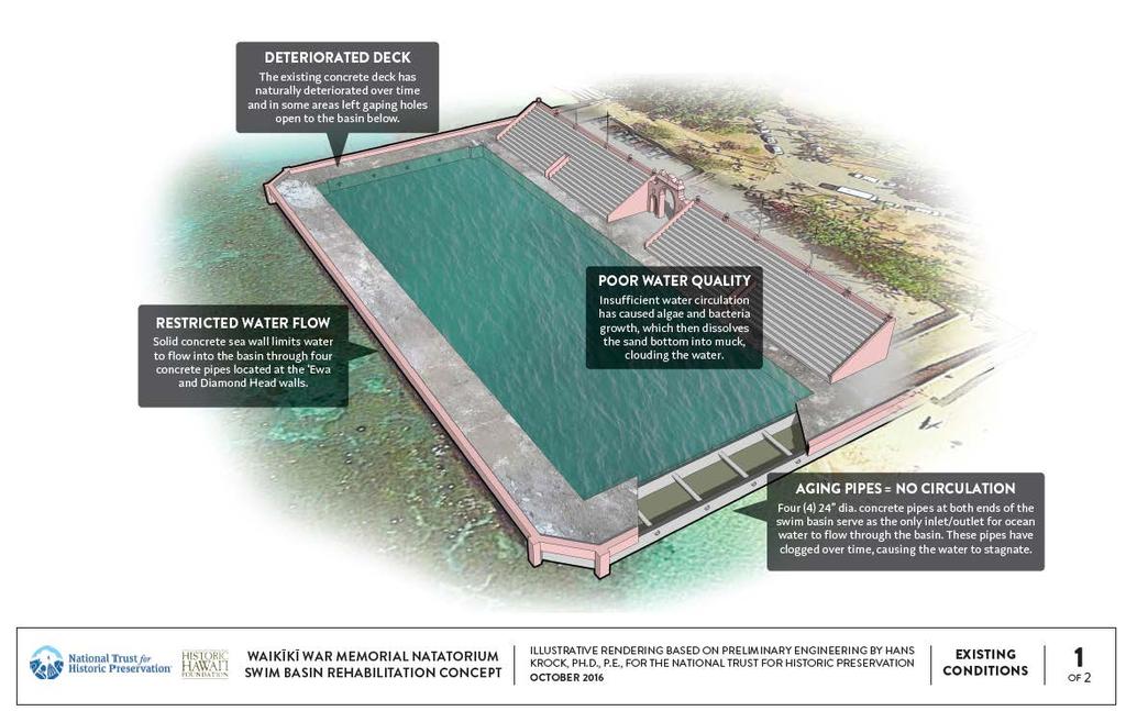
14 Current Conditions

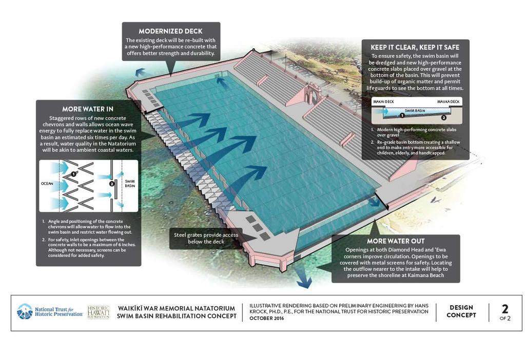
15 Rehabilitation Proposal The Rehabilitation alternative would replace the Natatorium swim basin s makai seawall with individual chevron units topped with decking. The chevrons would serve as a breakwater to prevent wave action against the bleachers, yet allow for sufficient water to circulate in the swim basin. CLEAN. A combination of wave energy, allowed into the swim area through chevrons that comprise the seawall, and circulation through openings in the side walls nearest to the bleacher structure would fully exchange the Natatorium with ocean water at least six times per day.

16 Rehabilitation Proposal CLEAR. To avoid murkiness in the water, silt would be dredged from the swim basin and replaced with an inert material, such as gravel, that could then be contoured to allow for a shallow and deep end, and covered with precast concrete panels. The use of silicone dioxide sand on top of the panels would be a safe and long-lasting solution.
17 Rehabilitation Proposal SIMPLE. The relative simplicity of this design essentially a sheltered ocean environment is its major advantage. The Natatorium could be regulated as a marine pool or protective cove and would not require the addition of special pumps or drainage infrastructure and related maintenance.
18 Rehabilitation Proposal
19 Historic Hawai i Foundation Supports Rehabilitation Retains and preserves the character and integrity of the historic structure; Honors the memory of veterans at a World War I memorial; Meets swim basin water quality standards; Protects the marine environment and coral reefs; Retains the adjacent beach; Protects the land environment and historic park; Provides recreational opportunities safe for children and those with disabilities; Safeguards public health and safety; Uses natural systems and wave action for water circulation so does not have energy costs or mechanical systems; Comparable in cost to the other alternatives; and Feasible to build and operate
20 EIS Alternatives City & County of Honolulu is preparing an Environmental Impact Statement to evaluate and compare alternatives: 1. NO ACTION 2. DEMOLITION/NO CONSTRUCTION 3. DEMOLITION/CONSTRUCT GROINS & SAND BEACH 4. REHABILITATION


21 Collapse Containment Install additional Warning signs Fence Pool Cover pool with Geo-net Apply bleacher coating OPTION #1: No Action

22 OPTION 2: Demolition/No Construction (Return to the Natural Shoreline) Complete demolition and removal of all structures Return to pre-construction condition Eliminates 87 parking spaces Photos courtesy City & County of Honolulu

23 OPTION 3: Demolish & Build Groins For Beach Demolish all structures Construct beach area with new groins Rebuild arch in different location Eliminates 46 parking stalls along the access drive and 31 Natatorium parking stalls now reserved for safety personnel. Safety Station relocated Restrooms rebuilt

24 OPTION 4: Rehabilitation Re-engineer the swim basin Cosmetic fixes to the bleachers, restrooms Retain shore-based amenities, including parking
25 From Here Ask City & County of Honolulu to evaluate the rehabilitation alternative in the EIS and give it a fair hearing Sign on letter at Environmental Impact Statement public comment

26 Save the Memorial The commitment to restoring the authentic monument is consistent with the best of American traditions: we do not discard our national treasures - Former Senator Daniel Akaka Referring to the Tomb of the Unknown Soldier
Building Coastal Resiliency at Plymouth Long Beach
 Building Coastal Resiliency at Plymouth Long Beach Department of Marine and Environmental Affairs March 30, 2017 Introducing Green Infrastructure for Coastal Resiliency Plymouth Long Beach & Warren s Cove
Delaware Chapter Surfrider Foundation - Indian River Inlet Monitoring
 Delaware Chapter Surfrider Foundation - Indian River Inlet Monitoring In 2012, the Delaware Surfrider Foundation Chapter formed the Surf Quality and Access Committee to focus on issues such as surf spot
The Sand Beaches of New Hampshire and Maine
 The Sand Beaches of New Hampshire and Maine Beach Preservation and Erosion Control Photographs provided by Joe Kelly and Steve Adams Cover photo: Reid State Park, ME Introduction The sand beaches of New
HARBOR INFRASTRUCTURE INVENTORIES Muskegon Harbor, Michigan
 HARBOR INFRASTRUCTURE INVENTORIES Muskegon Harbor, Michigan Harbor Location: Muskegon Harbor is located on the east shore of Lake Michigan, 114 miles northeast of Chicago, IL. Authority: River & Harbor
ALTERNATIVES FOR COASTAL STORM DAMAGE MITIGATION
 ALTERNATIVES FOR COASTAL STORM DAMAGE MITIGATION Dave Basco Old Dominion University, Norfolk, Virginia, USA National Park Service Photo STRUCTURAL (changes to natural, physical system) hardening (seawalls,
4/20/17. #32 - Coastal Erosion Case Histories - Lake Michigan
 Writing Assignment Due Monday by 11:59 pm #32 - Coastal Erosion Case Histories - Lake Michigan See main class web pages for detailed instructions Submit papers Illinois Compass No copying: Compass will
ALTERNATIVES FOR COASTAL STORM DAMAGE MITIGATION AND FUNCTIONAL DESIGN OF COASTAL STRUCTURES
 The University of the West Indies Organization of American States PROFESSIONAL DEVELOPMENT PROGRAMME: COASTAL INFRASTRUCTURE DESIGN, CONSTRUCTION AND MAINTENANCE A COURSE IN COASTAL DEFENSE SYSTEMS I CHAPTER
Dear Mr. Howard Ruben,
 Mr. Howard Ruben ( Howard.Ruben@usace.army.mil) The U.S. Army Corps of Engineers New York District Planning Division-Environmental Branch 26 Federal Plaza New York, New York 10278-0090 Dear Mr. Howard
Absecon Island Shore Protection The planning behind the project
 Absecon Island Shore Protection The planning behind the project Most residents of Atlantic City, Ventnor, Margate and Longport are now aware of upcoming plans to protect their common coastline with a beachfill
Impact of Hurricane Matthew on the Atlantic Coast of Florida
 Impact of Hurricane Matthew on the Atlantic Coast of Florida A coastal engineer was driving across country and his jeep broke down in front of a monastery. It was late in the day and the monks invited
Controlling Coastal erosion
 Controlling Coastal erosion Coastal Erosion Rates in the U.S. Coastal Erosion and Stabilization Economic pressures demanding the stabilization of beaches and coastlines are immense Coastal Erosion and
Part 9 Specific Land Uses - Foreshore & Waterway Development
 7 FORESHORE AND WATERWAY DEVELOPMENT This section applies to the following development uses proposed within the foreshore area (defined by LM LEP 2014), and contains Council s specific requirements for
Q1. What are the primary causes/contributors to coastal erosion at Westshore and the concept of longshore / littoral drift.
 Q1. What are the primary causes/contributors to coastal erosion at Westshore and the concept of longshore / littoral drift. In order of (timing related) contribution to present problem 1. Beach is too
USE OF SEGMENTED OFFSHORE BREAKWATERS FOR BEACH EROSION CONTROL
 .. CETN-III-22 4/84 PURPOSE: USE OF SEGMENTED OFFSHORE BREAKWATERS FOR BEACH EROSION CONTROL To provide information on the functional application of and general design considerations for using offshore
Redondo Beach Boat Launch Ramp Facility
 Redondo Beach Boat Launch Ramp Facility Feasibility Report for the California Department of Boating and Waterways 2015 Grant Cycle For the City of Redondo Beach Submitted by March 13, 2014 Table of Contents
HARBOR INFRASTRUCTURE INVENTORIES West Harbor, OH
 HARBOR INFRASTRUCTURE INVENTORIES West Harbor, OH Harbor Location: West Harbor is located on the southern shore of Lake Erie in the township of Catawba Island, OH about 50 miles east of Toledo, OH. Authority:
FINDING OF NO SIGNIFICANT IMPACT
 DEPARTMENT OF THE ARMY CHARLESTON DISTRICT, CORPS OF ENGINEERS 69A HAGOOD AVENUE CHARLESTON, SOUTH CAROLINA 29403-5107 FINDING OF NO SIGNIFICANT IMPACT EDISTO BEACH COASTAL STORM DAMAGE REDUCTION GENERAL
Coastal Erosion Impact on Rincón Infrastructure
 Lessons Learned and Best Practices: Resilience of Coastal Infrastructure Coastal Erosion Impact on Rincón Infrastructure Luis D. Aponte, Ph.D. P.E. luisd.aponte@upr.edu Professor University of Puerto Rico
HARBOR INFRASTRUCTURE INVENTORIES Oak Orchard Harbor, New York
 HARBOR INFRASTRUCTURE INVENTORIES Oak Orchard Harbor, New York Harbor Location: Oak Orchard Harbor is located on the southern shore of Lake Ontario at the mouth of Oak Orchard Creek in the village of Point
Nearshore Sediment Transport What influences the loss of sediment on Beaches? - Waves - Winds - Tidal Currents - River discharge - Runoff
 Tides & Beaches Nearshore Sediment Transport What influences the loss of sediment on Beaches? - Waves - Winds - Tidal Currents - River discharge - Runoff Oceans Ocean Topography Physical Structure of the
The Dynamic Coast. Right Place Resources. A presentation about the interaction between the dynamic coast and people
 The Dynamic Coast Houses threatened by coastal erosion in California Right Place Resources A presentation about the interaction between the dynamic coast and people For the rest of the presentations in
BEACH NOURISHMENT PROJECTS IN CARBONATE MATERIAL BEACH
 Submitted February, 2006 BEACH NOURISHMENT PROJECTS IN CARBONATE MATERIAL BEACH Ryuichiro Nishi 1, Robert G. Dean 2 and Mario P. de Leon 1 1 Department of Ocean Civil Engineering, Kagoshima University,
COUNTY OF SAN MATEO Parks Department
 Agenda Item 5.B COUNTY OF SAN MATEO Parks Department DATE: March 16, 2015 COMMISSION MEETING DATE: April 9, 2015 TO: FROM: Parks and Recreation Commission Cecily Harris, Development Consultant SUBJECT:
SIDEWALK GUIDELINES April 14, 2008
 SIDEWALK GUIDELINES April 14, 2008 I. Introduction The issue of sidewalks represents a delicate balance that must be considered carefully. On the one hand, in certain circumstances, sidewalks are needed
COPE PARK MASTER PLAN
 COPE PARK MASTER PLAN CBJ Parks & Recreation Department is in the process of creating a Master Plan for the Cope Park Area. New restrooms are designated to be constructed in the park in the next year.
Tampa: Davis Islands Recreation Area
 1) PROCESS a) Provide As-Built Documentation i) Elements Design Team completed measured as-built drawings as well as extensive photo documentation of the building. ii) Elements Design Team met and held
Bear Cove Coastline Reestablishment
 Coastal and Ocean Engineering Undergraduate Student Forum, COASTAL-2013 Faculty of Engineering and Applied Science, Memorial University, St. john s, NL, Canada March, 2013 Bear Cove Coastline Reestablishment
Feasibility Study for Restoration of Titlow Lagoon Fish Passage. South Puget Sound Salmon Enhancement Group
 Feasibility Study for Restoration of Titlow Lagoon Fish Passage South Puget Sound Salmon Enhancement Group January 2010 Feasibility Study for Restoration of Titlow Lagoon Fish Passage Prepared for South
6/19/2006 The Reef Ball Foundation 1
 6/19/2006 The Reef Ball Foundation 1 Overview Reef Balls are prefabricated concrete modules used as a base for natural coral reefs to form. Reef Balls have been used in 55 countries in over 3,500 projects
LAB: WHERE S THE BEACH
 Name: LAB: WHERE S THE BEACH Introduction When you build a sandcastle on the beach, you don't expect it to last forever. You spread out your towel to sunbathe, but you know you can't stay in the same spot
North Shore of Long Island, Feasibility Study
 North Shore of Long Island, Asharoken New York Asharoken, Feasibility Study Asharoken, NY Public Meeting June 30, 2015 US Army Corps of Engineers US Army Corps of Engineers New York BUILDING STRONG BUILDING
Earth Science Chapter 16 Section 3 Review
 Name: Class: Date: Earth Science Chapter 16 Section 3 Review Multiple Choice Identify the choice that best completes the statement or answers the question. 1. The movement of water that parallels the shore
ST. LUCIE COUNTY, FLORIDA
 ST. LUCIE COUNTY, FLORIDA COASTAL STORM RISK MANAGEMENT STUDY Draft Feasibility Study & Integrated Environmental Assessment Public Meeting Presented by U.S. Army Corps of Engineers Jacksonville District
HARBOR INFRASTRUCTURE INVENTORIES Lexington Harbor, Michigan
 HARBOR INFRASTRUCTURE INVENTORIES Lexington Harbor, Michigan Harbor Location: Lexington Harbor is located on the west shore of Lake Huron about 20 miles north of Port Huron, MI. Authority: Rivers & Harbors
Understanding the Tsunami Wave
 The First Tsunami attack on Sri Lanka Krakatoa Island 27 th August 1883 Understanding the Tsunami Wave Generation Propagation Nearshore Transformation Shoreline Entry Inland Dissipation 1 Generation and
Hale iwa Improvement District Project
 Hale iwa Improvement District Project Hale iwa, North Shore, O ahu October 10, 2017 Public Informational Meeting Environmental Impact Statement Preparation Notice Waialua Elementary School 67-020 Waialua
Tsunamis. Tsunamis COMMUNITY EMERGENCY RESPONSE TEAM TSUNAMIS
 Tsunamis Tsunamis Tell the participants that tsunamis are ocean waves that are produced by underwater earthquakes or landslides. The word is Japanese and means harbor wave because of the devastating effects
Oceans in Motion: Waves and Tides
 Oceans in Motion: Waves and Tides Waves Waves are among the most familiar features in the ocean. All waves work similarly, so although we are talking about ocean waves here, the same information would
MOREHEAD CITY HARBOR, NC. Dredged Material Management Plan (DMMP)
") MOREHEAD CITY HARBOR, NC Dredged Material Management Plan (DMMP) Public Meeting/Info Session 15 January 2014 US Army Corps of Engineers Morehead City Harbor DMMP Presentation Topics Morehead City Harbor
MOREHEAD CITY HARBOR, NC Dredged Material Management Plan (DMMP) Public Meeting/Info Session 15 January 2014 US Army Corps of Engineers Morehead City Harbor DMMP Presentation Topics Morehead City Harbor
ST. JOSEPH PENINSULA, GULF COUNTY, FLORIDA Beach Re-Nourishment and Environmental Enhancement Project RECOMMENDATIONS
 ST. JOSEPH PENINSULA, GULF COUNTY, FLORIDA Beach Re-Nourishment and Environmental Enhancement Project RECOMMENDATIONS January 23, 2018 543 Harbor Boulevard, Suite 204 Destin, Florida 32541 850.654.1555
CITY OF OVERLAND PARK MAINTENANCE PROGRAM
 CITY OF OVERLAND PARK 2018-2022 MAINTENANCE PROGRAM Adopted April 2017 *Indicates project costs not included in program totals Page 1 Maintenance Program Definition Maintenance as included in the City
Chapter 10 Lecture Outline. The Restless Oceans
 Chapter 10 Lecture Outline The Restless Oceans Focus Question 10.1 How does the Coriolis effect influence ocean currents? The Ocean s Surface Circulation Ocean currents Masses of water that flow from one
Overview. Beach Features. Coastal Regions. Other Beach Profile Features. CHAPTER 10 The Coast: Beaches and Shoreline Processes.
 Overview CHAPTER 10 The Coast: Beaches and Shoreline Processes Coastal regions constantly change. The beach is a dominant coastal feature. Wave activity continually modifies the beach and coastal areas.
NCCOE EA Coastal Adaptation Guidelines. Section I Emerging Technology Novel Alternative Approaches to Coastal Erosion
 NCCOE EA Coastal Adaptation Guidelines Section I Emerging Technology Novel Alternative Approaches to Coastal Erosion Alessio Mariani, Doug Lord, Tony Webb James Carley, Matt Blacka, Brett Miller Ian Turner,
FINAL ENVIRONMENTAL IMPACT STATEMENT ON BROWARD COUNTY SHORE PROTECTION PROJECT SEGMENTS II AND III BROWARD COUNTY, FLORIDA
 FINAL ENVIRONMENTAL IMPACT STATEMENT ON BROWARD COUNTY SHORE PROTECTION PROJECT SEGMENTS II AND III BROWARD COUNTY, FLORIDA 1. PROJECT PURPOSE AND NEED 1.1. PROJECT AUTHORITY. 1.1.1. INITIAL AUTHORIZATION.
Whose Beach Is It Anyway? Managing Seals at Children s Pool, La Jolla CA. James H. Lecky Southwest Region, National Marine Fisheries Service
 Whose Beach Is It Anyway? Managing Seals at Children s Pool, La Jolla CA James H. Lecky Southwest Region, National Marine Fisheries Service Harbor seals have been hauling out and pupping on a public beach
Richardson Center Corporation By Gary Phillips University at Buffalo Law Student
 FACT SHEET November 7, 2008 Richardson Center Corporation By Gary Phillips University at Buffalo Law Student What is the agency s website and contact information? Website: http://www.richardson-olmsted.com/
HARBOR INFRASTRUCTURE INVENTORIES Kenosha Harbor, Wisconsin
 HARBOR INFRASTRUCTURE INVENTORIES Kenosha Harbor, Wisconsin Harbor Location: Kenosha Harbor is on the west shore of Lake Michigan about 54 miles north of Chicago, Illinois. Authority: River & Harbor Acts
Today: Coastal Issues and Estuaries
 Today: Coastal Issues and Estuaries Coastal issues Human effect on coastlines What is an estuary Why are they so important? Circulation of water in estuary Environmental issues Coastal Issues: Problem
RENOVATION MASTER PLAN
 RENOVATION MASTER PLAN For: Field Club of Omaha Omaha, Nebraska DATE: JUNE 20,, 2018 P r e p a r e d b y : 3250 BRINKERHOFF ROAD KANSAS CITY, KANSAS 66115 PHONE: 913.621.5214 FAX: 913.621.0760 EXECUTIVE
Voting should indicate preference to one option (Option 1, Option 2, or Option 3)
") Proposals for Wied Il-Buni Options being considered for proposal for the Ministry of Infrastructure to be taken up with Transport Malta following the extension of Terminal 1 by Malta Freeport Corporation.
Proposals for Wied Il-Buni Options being considered for proposal for the Ministry of Infrastructure to be taken up with Transport Malta following the extension of Terminal 1 by Malta Freeport Corporation.
Discussion on Super Splash USA. December 14, 2015
 Discussion on Super Splash USA December 14, 2015 Super Splash Elevated Sundeck Filter Water Slides Pebble Beach Concessions Avalanche Slide Main Pool Catalina Cove Drop Slides Filter/Admin Entry BH/ Restrooms
State Route 28 Shared Use Path & Safety/Stormwater Enhancements Public Information Meeting
 State Route 28 Shared Use Path & Safety/Stormwater Enhancements Public Information Meeting Thursday, March 30, 2017 4-7 p.m. Presentation at 5:30 p.m. The Chateau at Incline Village 955 Fairway Blvd. Incline
New Orleans Municipal Yacht Harbor
 New Orleans Municipal Yacht Harbor Marina Schematic Design Update 601 Poydras St., Suite 1860 New Orleans, LA, 70130 504-648-3560 Post-Katrina Municipal Yacht Harbor: Introduction The MYH was an approximate
Coastal Environments Oceanographic and Engineering Expertise
 Coastal Environments Oceanographic and Engineering Expertise Coastal Environments La Jolla, CA www.coastalenvironments.com 14 May 2004 CE Ref. No. 04-05 EcoSystems Management Associates, Inc. Carlsbad,
Modeling Beach Erosion
 Ocean Lecture & Educator s Night May 16, 2012 Modeling Beach Erosion Below is an overview of the activity Modeling Beach Erosion (New Jersey Sea Grant Consortium, Education Program) to incorporate information
HARBOR INFRASTRUCTURE INVENTORIES Fairport Harbor, OH
 HARBOR INFRASTRUCTURE INVENTORIES Fairport Harbor, OH Harbor Location: Fairport Harbor is located at the mouth of the Grand River on the southern shore of Lake Erie in the city of Fairport, OH, approximately
Citizen Advisory Committee Meeting. November 15, 2011 MPRB Headquarters- 6:30-8:30 p.m.
 Citizen Advisory Committee Meeting November 15, 2011 MPRB Headquarters- 6:30-8:30 p.m. Charge for Wirth Lake Area Citizen Advisory Committee: Prepare recommendations for the Board of Commissioners on the
RE: Hurricane Matthew Beach Damage Assessment and Recommendations [CSE 2416]
![RE: Hurricane Matthew Beach Damage Assessment and Recommendations [CSE 2416]](/thumbs/83/87675702.jpg "RE: Hurricane Matthew Beach Damage Assessment and Recommendations [CSE 2416]") October 25, 2016 Iris Hill Town Administrator Town of Edisto Beach 2414 Murray St Edisto Beach SC 29438 RE: Hurricane Matthew Beach Damage Assessment and Recommendations [CSE 2416] Dear Iris, Hurricane
October 25, 2016 Iris Hill Town Administrator Town of Edisto Beach 2414 Murray St Edisto Beach SC 29438 RE: Hurricane Matthew Beach Damage Assessment and Recommendations [CSE 2416] Dear Iris, Hurricane
An Update of Coastal Erosion in Puerto Rico
 Jack Morelock and Maritza Barreto An Update of Coastal Erosion in Puerto Rico Department of Marine Sciences, University of Puerto Rico at Mayagüez and Geography Department, University of Puerto Rico at
Protecting our Beaches
 Protecting our Beaches South Amelia Island Shore Stabilization Project Nassau County, FL Mr. Drew Wallace President South Amelia Island Shore Stabilization Association (SAISSA) Mr. Bill Moore, AICP Project
The McDonald Golf Family
 The McDonald Golf Family Bidermann G.C. GlenRiddle G.C. Odessa National G.C. Green Valley C.C. King Carter G.C. C.C. of Maryland Bent Creek C.C. Washington Golf and C.C. Bethpage Black Winged Foot G.C.
HARBOR INFRASTRUCTURE INVENTORIES Black Rock Lock & Tonawanda Harbor, NY
 HARBOR INFRASTRUCTURE INVENTORIES Black Rock Lock & Tonawanda Harbor, NY Harbor Location: The Black Rock Channel and Tonawanda Harbor are located along the east side of the Niagara River in the City of
STATUS REPORT FOR THE SUBMERGED REEF BALL TM ARTIFICIAL REEF SUBMERGED BREAKWATER BEACH STABILIZATION PROJECT FOR THE GRAND CAYMAN MARRIOTT HOTEL
 August 23 STATUS REPORT FOR THE SUBMERGED REEF BALL TM ARTIFICIAL REEF SUBMERGED BREAKWATER BEACH STABILIZATION PROJECT FOR THE GRAND CAYMAN MARRIOTT HOTEL performed by Lee E. Harris, Ph.D., P.E. Consulting
HARBOR INFRASTRUCTURE INVENTORIES Lorain Harbor, Ohio
 HARBOR INFRASTRUCTURE INVENTORIES Lorain Harbor, Ohio Harbor Location: Lorain Harbor is located on the southern shore of Lake Erie in the city of Lorain, OH about 45 miles west of Cleveland, OH. Authority:
LAKE BLUFF PARK DISTRICT BLAIR PARK SWIMMING POOL Questions and Answers OVERVIEW
 LAKE BLUFF PARK DISTRICT BLAIR PARK SWIMMING POOL Questions and Answers www.lakebluffparks.org OVERVIEW Q: How did the community rate the pool on the Community Wide survey? A: The top three highest rated
RECOMMENDATION: 1) that the existing Traffic Bridge be replaced with a modern steel truss bridge as outlined in this report;
 that the existing Traffic Bridge be replaced with a modern steel truss bridge as outlined in this report;") E) Traffic Bridge Needs Assessment and Functional Planning Study Final Report (File: CK 6050 8; IS 6332 24; and IS 6050 2) RECOMMENDATION: 1) that the existing Traffic Bridge be replaced with a modern
E) Traffic Bridge Needs Assessment and Functional Planning Study Final Report (File: CK 6050 8; IS 6332 24; and IS 6050 2) RECOMMENDATION: 1) that the existing Traffic Bridge be replaced with a modern
OECS Regional Engineering Workshop September 29 October 3, 2014
 B E A C H E S. M A R I N A S. D E S I G N. C O N S T R U C T I O N. OECS Regional Engineering Workshop September 29 October 3, 2014 Coastal Erosion and Sea Defense: Introduction to Coastal/Marine Structures
Volume and Shoreline Changes along Pinellas County Beaches during Tropical Storm Debby
 Volume and Shoreline Changes along Pinellas County Beaches during Tropical Storm Debby Ping Wang and Tiffany M. Roberts Coastal Research Laboratory University of South Florida July 24, 2012 Introduction
Coastal issues: Beaches and Estuaries. Recent Sea Level: Beaches: Baltimore D.C. Patomac R. Chesapeake Bay
 Coastal issues: Beaches and Estuaries Definitions: Coast = broad zone where both marine & terrestrial processes act It includes the beach, lagoons, marshes, bars etc. Coastal processes act to shape the
Lee E. Harris, Ph.D., P.E. Assoc. Professor of Ocean Engineering. Doug Bowlus and Ashley Naimaster Ocean Engineering Graduate Students
 FLORIDA TECH OCEAN ENGINEERING PROFESSOR LEE HARRIS AND HIS GRADUATE STUDENTS ASSIST WITH POST-HURRICANE IVAN CORAL REEF RESTORATION IN THE CAYMAN ISLANDS Lee E. Harris, Ph.D., P.E. Assoc. Professor of
Figure79. Location map for the 10 NJBPN profile sites in Atlantic County, NJ 155
 154 Figure79. Location map for the 10 NJBPN profile sites in Atlantic County, NJ 155 ATLANTIC COUNTY SPRING 2009 to FALL 2010 The Atlantic County coastline consists of three barrier islands. Between Little
Assateague Island National Seashore North End Restoration Project Timeline
 Assateague Island National Seashore North End Restoration Project Timeline Date Event Some information provided in the Project Introduction document. Detailed events are available in a timeline compiled
Swimming Pool IAQUALINK WEB CONNECT
 Swimming Pool For all pool equipment, two rules apply: consult the manufacturer documentation and hire professionals. The recommendations made in this section are general to products typically installed
Unit 11 Lesson 2 How Does Ocean Water Move? Copyright Houghton Mifflin Harcourt Publishing Company
 Unit 11 Lesson 2 How Does Ocean Water Move? Catch a Wave A wave is the up-and-down movement of surface water. Catch a Wave Catch a Wave (wave effects) Surface waves are caused by wind pushing against
History Recent Problems Alternative Routes
 History Recent Problems Alternative Routes Built in 1936 Length: 8.4 miles Made up of two suspension bridges Meet in the middle of the San Francisco Bay at Yerba Buena Island Double-deck bridge Average
Dauphin Island East End Beach and Barrier Island Restoration Project. Beau Buhring South Coast Engineers
 Dauphin Island East End Beach and Barrier Island Restoration Project Beau Buhring South Coast Engineers Funding Funded with qualified outer continental shelf oil and gas revenues by the Coastal Impact
OCN 201: Coastal Erosion and Beach Loss
 OCN 201: Coastal Erosion and Beach Loss This lecture was prepared from slides and notes kindly provided by: Prof. Chip Fletcher Department of Geology and Geophysics, University of Hawaii Chip Fletcher
HARBOR INFRASTRUCTURE INVENTORIES Cheboygan Harbor, Michigan
 HARBOR INFRASTRUCTURE INVENTORIES Cheboygan Harbor, Michigan Harbor Location: Cheboygan Harbor is located at the mouth of the Cheboygan River, emptying into western Lake Huron approximately 16 miles southeast
BYLAW NUMBER
 THE CORPORATION OF THE TOWN OF MONO BYLAW NUMBER 2011-46 BEING A BYLAW RELATING TO FENCES ENCLOSING PRIVATELEY OWNED OUTDOOR SWIMMING POOLS WHEREAS section 210, paragraph 30 of the Municipal Act (R.S.O.
Chapter 12: Coasts (after a brief review of Tides)
") Chapter 12: Coasts (after a brief review of Tides) 1 Questions from previous classes: What happens when a wave meets a current? wave = people walking current = bus If wave goes with the current, the wave
Chapter 12: Coasts (after a brief review of Tides) 1 Questions from previous classes: What happens when a wave meets a current? wave = people walking current = bus If wave goes with the current, the wave
OCEANS. Main Ideas. Lesson 2: Ocean Currents Ocean Currents help distribute heat around Earth.
 Oceans Chapter 10 OCEANS Main Ideas Lesson 2: Ocean Currents Ocean Currents help distribute heat around Earth. Lesson 3: The Ocean Shore The shore is shaped by the movement of water and sand. OCEANS SO
HARBOUR SEDIMENTATION - COMPARISON WITH MODEL
 HARBOUR SEDIMENTATION - COMPARISON WITH MODEL ABSTRACT A mobile-bed model study of Pointe Sapin Harbour, in the Gulf of St. Lawrence, resulted in construction of a detached breakwater and sand trap to
FINAL REPORT. Yonkers Creek Migration Barrier Removal Project Wonderstump Road Del Norte County. Submitted By:
 FINAL REPORT Yonkers Creek Migration Barrier Removal Project Wonderstump Road Del Norte County Submitted By: Del Norte County Community Development Department Yonkers Creek Migration Barrier Removal Project
Protecting the Lost Colony of Roanoke with Innovative Shoreline Stabilization Solutions
 Protecting the Lost Colony of Roanoke with Innovative Shoreline Stabilization Solutions Matthew Starr, PG Jeff Tabar, PE, D.CE Corbitt Kerr, PhD, PE February 8, 2018 Agenda 1 Lost Colony History 2 Project
RI Regulatory Setbacks & Buffers: Coastal Management Issues
 RI Regulatory Setbacks & Buffers: Coastal Management Issues New England Onsite Wastewater Training Program @ URI OWT 155 - November 29, 2012 James Boyd - Coastal Policy Analyst Photo: October 30, 2012
Atlantic Coast of Long Island, Jones Inlet to East Rockaway Inlet, Long Beach Island, NY Construction Update
 Atlantic Coast of Long Island, Jones Inlet to East Rockaway Inlet, Long Beach Island, NY Construction Update June 2016 US Army Corps of Engineers Project Purpose Three specific damage mechanisms of coastal
Geology of the Hawaiian Islands
 Geology of the Hawaiian Islands Class 24 8 April 2004 Any Questions? Rise and fall of sea level and its effect on Hawai`i Sea level Has fluctuated up and down many times in the geologic past Evidence?
The Impact on Great South Bay of the Breach at Old Inlet Charles N. Flagg School of Marine and Atmospheric Sciences, Stony Brook University
 The Impact on Great South Bay of the Breach at Old Inlet Charles N. Flagg School of Marine and Atmospheric Sciences, Stony Brook University This is the sixth in a series of reports describing the evolution
GLOBAL CORAL REEF ALLIANCE A non-profit organization for protection and sustainable management of coral reefs
 GLOBAL CORAL REEF ALLIANCE A non-profit organization for protection and sustainable management of coral reefs Global Coral Reef Alliance, 37 Pleasant Street, Cambridge, MA 02139, USA Telephone: 617-864-4226
Salt Ponds Shore Zone Modeling for Breakwater Placement: Summary Report
 Salt Ponds Shore Zone Modeling for Breakwater Placement: Summary Report Virginia Institute of Marine Science May 2014 Salt Ponds Shore Zone Modeling for Breakwater Placement: Summary Report For Waterway
HARBOR INFRASTRUCTURE INVENTORIES Marquette Harbor, Michigan
 HARBOR INFRASTRUCTURE INVENTORIES Marquette Harbor, Michigan Harbor Location: Marquette Harbor is located in Marquette Bay on the south shore of Lake Superior, 160 miles west of Sault Ste. Marie, MI and
Raleigh Park Open House #2 Summary (5/23/17)
") Raleigh Park Open House #2 Summary (5/23/17) Nearly 50 community members participated in an open house meeting about Raleigh Park on 5/23/17. During the meeting, staff presented concepts for changes to
Raleigh Park Open House #2 Summary (5/23/17) Nearly 50 community members participated in an open house meeting about Raleigh Park on 5/23/17. During the meeting, staff presented concepts for changes to
ROOK COMPANY PANAMA CANAL BANCROFT LIBRARY
 F 1563 ROOK COMPANY PANAMA CANAL BANCROFT LIBRARY University of California Berkeley TTTe PANAMA CANAL I The Land Divided Fin The World Unvted ' A Pidtorial Review of its Construction together with
4/20/17. #31 - Coastal Erosion. Coastal Erosion - Overview
 Writing Assignment Due Monday by 11:59 pm #31 - Coastal Erosion Beach front property! Great View! Buy now at a great price! See main class web pages for detailed instructions Essays will be submitted in
Norwalk Harbor: The Jewel of Long Island Sound. A Presentation by the Norwalk Harbor Management Commission
 Norwalk Harbor: The Jewel of Long Island Sound A Presentation by the Norwalk Harbor Management Commission 2018 State of the Harbor Meeting December 13, 2018 The City of Norwalk in Southwest Connecticut
Shorelines Earth - Chapter 20 Stan Hatfield Southwestern Illinois College
 Shorelines Earth - Chapter 20 Stan Hatfield Southwestern Illinois College The Shoreline A Dynamic Interface The shoreline is a dynamic interface (common boundary) among air, land, and the ocean. The shoreline
Modeling Sediment Transport Along the Upper Texas Coast
 Modeling Sediment Transport Along the Upper Texas Coast David B. King Jr. Jeffery P. Waters William R. Curtis Highway 87 roadbed, Jefferson County Galveston District Corps Sabine Pass to San Luis Pass
Ch 9: Waves. Wind waves. Formation of a wind wave
 Ch 9: Waves 1. Features of Waves 2. Deep-water, shallow water and transitional waves 3. Breaking Waves 4. Wind Waves 5. Tsunamis Cf. Fig. 9-2 Waves are created by a disturbance. * wind (wind waves, L=
Chapter. The Dynamic Ocean
 Chapter The Dynamic Ocean An ocean current is the mass of ocean water that flows from one place to another. 16.1 The Composition of Seawater Surface Circulation Surface Currents Surface currents are movements