History Recent Problems Alternative Routes
|
|
|
- George Porter
- 5 years ago
- Views:
Transcription

1

2 History Recent Problems Alternative Routes

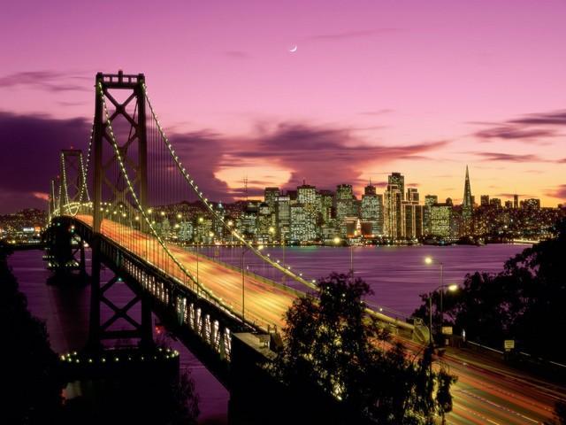
3 Built in 1936 Length: 8.4 miles Made up of two suspension bridges Meet in the middle of the San Francisco Bay at Yerba Buena Island Double-deck bridge Average daily traffic: 280,000 vehicles Connects San Francisco with Oakland Cost: $4
4
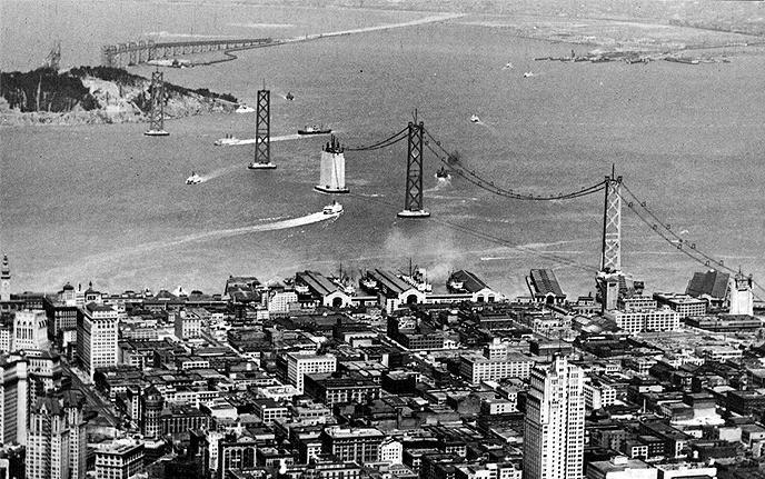
5 Ferries carried 46 million people between San Francisco and Oakland yearly An underwater tunnel was considered Rejected because it would not be big enough to handle the auto traffic Mass production of the automobile called for bridge to be built

6 Took 3 years to build Opened November 12, 1936 Cost $77 million Originally: 6 lanes of traffic on upper level Truck traffic and railway cars on lower level

7 1936 traffic on bridge exceeded expected traffic levels for 1950 Tolls for bridge were lowered to attract ferry users 1958 demand for bridge was so great it had to be reconfigured Changes: Railway system was removed Upper level: 5 lanes of traffic going East Lower level: 5 lanes of traffic going West


8 October, Magnitude Quake 250 Ton section of the upper deck on the East Side collapsed Killed one person

9 Result of seismic studies after Earthquake All four sections needed to be drastically improved Entirely new structures arising Total Cost estimated to be $6 Billion Completion date slotted for late 2013

10 One mile stretch linking Interstate 80 to Bay Bridge Needed to completely remove and replace original foundation $429 Million Each section demolished and rebuilt one at a time Major lane reconfigurations, traffic shifts, and temporary road ways being employed during work Work scheduled at off-peak hours (weekends and nights)


11 San Francisco to Yerba Buena and Treasure Islands Resurfacing of bridge deck Steel added to suspension rails or rails were replaced 17 million tons of new steel brought in All work done at night to minimize impact on traffic


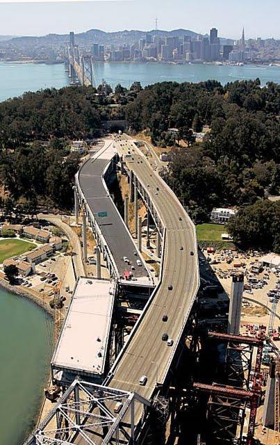
12 Part of the new East Span Single Suspension Tower designed to withstand major earthquake Side-by-Side Decks Estimated completion date is late 2013


13 Between SAS and Oakland touchdown Longest Portion of new East Span 1.2 miles Five Lanes, 10 foot shoulders to keep traffic moving

14 Will connect Interstate 80 in Oakland to the new East Span Involves building two new roadway sections New westbound lanes connecting the East Span New eastbound lanes coming off the bridge to Interstate 80 Traffic will shift to new westbound lanes first Demolition of old westbound lanes will allow for connection of the new eastbound lanes coming off the bridge


15 Will connect the Yerba Buena Island to SAS Connecting side-by-side East Span decks to upper and lower decks of YBI tunnel and West Span decks Traffic shifted to a temporary detour that connects East Span to the tunnel Movements and building of new sections and detours closed the entire bridge labor day weekend 2007
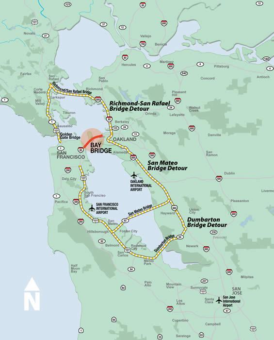
16
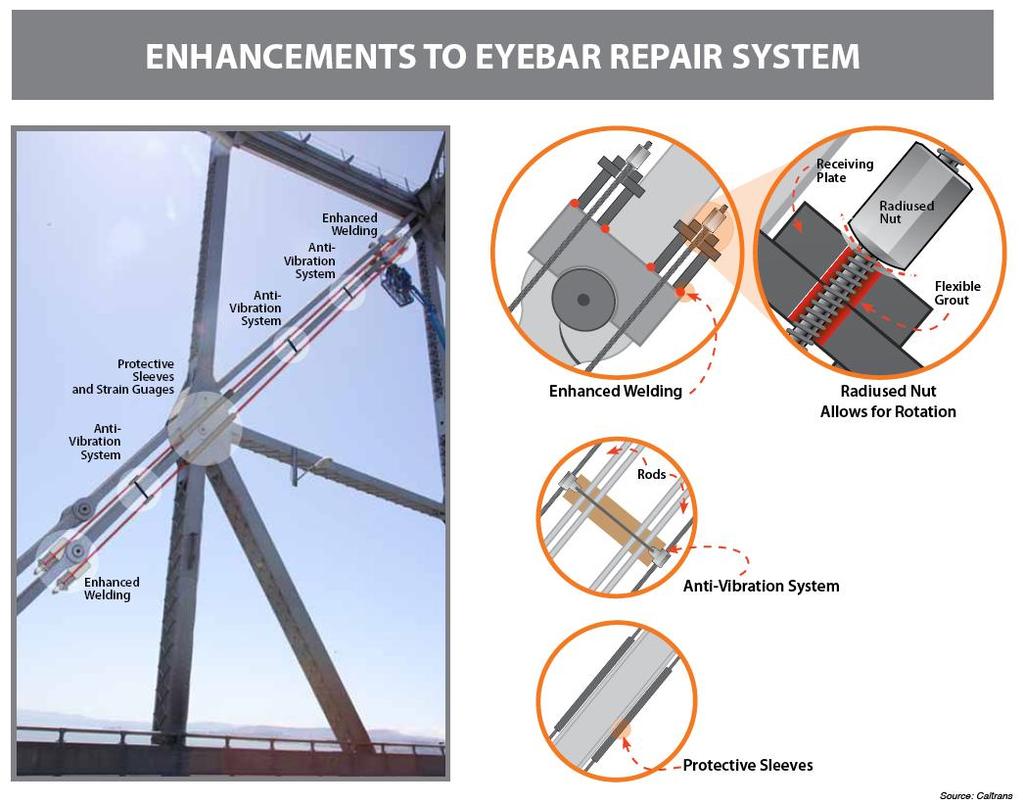
17 Labor Day Weekend 2009 During closure for retrofitting, major crack found in an eyebar (see picture) CalTrans created new materials and repaired bridge Was not inspected by Federal Highway Administration, but state inspection reports were used
18 October 27, ,000 lbs of metal came crashing down on rush hour traffic Falling debris hit cars, but no injuries/deaths The falling pieces were the same ones repaired over Labor Day Weekend Closure lasted for roughly 6 days The S-Curve Curvy temporary section with more than 50 accidents (1 fatal) in two months
19 Failures attributed to design affects Tight and lack of secure attachment of components Repairs took a while, and hit a few snags Modifications Structural welding, addition of structural components, monitors, and protective measures Opening postponed until November 2, 2009

20
21 Shut down main link of Bay Bridge rerouting roughly 280,000 daily users Disrupted regional businesses Workers stayed home, flocked to public transportation, or were stuck in horrible traffic on alternate routes
22

23 Golden Gate Bridge Approx. 30 mi away from Bay Bridge Very congested Can add over an hour onto commute Cost: $6 San Mateo Bridge Experiences 40% more traffic than usual Approx. 40 miles from Bay Bridge Can add half an hour hour onto commute Cost: $4

24 San Rafael Bridge Approx. 20 mi from Bay Bridge Can add up to 40 minutes onto commute Cost: $4 Ferries Runs times per weekday Trips take minutes between Oakland and San Francisco Cost: $12.50 round trip

25 BART Bay Area Rapid Transit Subway system Deal with overflow conditions Ran extra trains and longer hours When Bay Bridge is closed, ridership can increase up to 49% Set ridership record on Sept 8 th while bridge was closed 437,000 people Most people in 37 year history of BART Cost: Varies depending on destination $6.20 to cross San Francisco Bay

26 Seismic Retrofitting Project still ongoing Alternative routes remain congested when Bay Bridge is closed Recent repairs have been successful but problems reflect growing concern about bridges, and the American transportation infrastructure, today.
Highway 17 Transportation Improvement Study
 Final Report Highway 17 Transportation Improvement Study prepared for Santa Cruz County Regional Transportation Commission (SCCRTC) prepared by Planning and Engineering, Inc. 1155 North First Street, Suite
Tunnel Reconstruction South 5 th Street Association October 16, 2018
 Tunnel Reconstruction South 5 th Street Association October 16, 2018 Reconstructing the Tunnel 2 Service During Tunnel Reconstruction April 2019 through July 2020 3 Projected Cross River Travel Paths of
Preview. Tables in your paper Mass Transit as alternative to auto California s problems in urban transportation
 Preview Tables in your paper Mass Transit as alternative to auto California s problems in urban transportation Integrating tables in your writing Commuting in Urban Areas Last time auto and congestion
Replacement of N. Carlin Springs Road Bridge over George Mason Dr.
 Replacement of N. Carlin Springs Road Bridge over George Mason Dr. Approximate schedule with phases and proposed Maintenance of Travel (MOT) plans February 2017 Project Elements Removal of existing bridge
CURRENT NEWS & INFORMATION FROM
 CURRENT NEWS & INFORMATION FROM Attached is an article that was published by Ayres Associates in their May 2005 issue of their corporate magazine, TRENDS. Ayres Associates was hired to handle the many
MOVEABLE BARRIER. Congestion Management Solutions
 MOVEABLE BARRIER Congestion Management Solutions 1 Portland area morning congestion (AM) 2 Portland area afternoon congestion (PM) 3 30 year planning - Portland Area 100% Growth over 30 years 4 Movable
Welcome. Thank you for your interest in the Lewis & Clark Viaduct Concept Study
 Welcome Thank you for your interest in the Lewis & Clark Viaduct Concept Study Please use the arrows in the upper left hand corner to navigate through the presentation. Use the envelope icon to ask a question
PHASE 1 WIND STUDIES REPORT
 PHASE 1 WIND STUDIES REPORT ENVIRONMENTAL STUDIES AND PRELIMINARY DESIGN FOR A SUICIDE DETERRENT SYSTEM Contract 2006-B-17 24 MAY 2007 Golden Gate Bridge Highway and Transportation District Introduction
# Southeastern Wisconsin Regional Freeway System Reconstruction Study and Preliminary Recommended Plan
 #70421 Southeastern Wisconsin Regional Freeway System Reconstruction Study and Preliminary Recommended Plan Public Information Meetings and Hearings May June 2002 1 Reason for Freeway System Study 270-mile
Tunnel Reconstruction Brooklyn CB 1 August 14, 2018
 Tunnel Reconstruction Brooklyn CB 1 August 14, 2018 Reconstructing the Tunnel 2 Service During Tunnel Reconstruction April 2019 through July 2020 3 Projected Cross River Travel Paths of Customers The Service
POTENTIAL SANTA CLARA COUNTY TRANSPORTATION MEASURE
 POTENTIAL SANTA CLARA COUNTY TRANSPORTATION MEASURE OVERALL DRAFT EXPENDITURE PLAN TRANSIT/Mode Shift Millions % BART to Downtown San Jose/Santa Clara* 1,400 23% Caltrain Capacity & Safety 1,014 17% Mass
PROJECT FACT SHEET May 25, 2018
 SITE CHALLENGES & PROJECT BACKGROUND In 2014, the City of Aspen identified the Castle Creek Bridge and Hallam Street corridor as a deficient link in Aspen s bicycle and pedestrian network. Safe and efficient
Preview. Second midterm Tables in your paper Mass Transit as alternative to auto California s problems in urban transportation
 Preview Second midterm Tables in your paper Mass Transit as alternative to auto California s problems in urban transportation Score Distribution 1 st Midterm 2 nd Midterm 3.5-4.0 8% 21% 3.0-3.5 23% 34%
I-25 South Gap Project Monument to Castle Rock
 I-25 South Gap Project Monument to Castle Rock Project Overview Castle Rock Town Council April 3, 2018 by Chuck Attardo I-25 South: Monument to C-470 An Important Corridor to Colorado Links the state s
Kentucky s Surface Transportation System
 Kentucky s Surface Transportation System ROAD AND BRIDGE CONDITIONS, TRAFFIC SAFETY, TRAVEL TRENDS, AND NEEDS MARCH 2018 PREPARED BY WWW.TRIPNET.ORG Founded in 1971, TRIP of Washington, DC, is a nonprofit
Interstate Route 77 / US Route 62 / State Route 687 (Fulton Road) Transportation Improvement Project. Prepared September 6, 2017
 Transportation Improvement Project. Prepared September 6, 2017") EODOT Project: ODOT Project: STA-IR 77-.50; PID 00290 Interstate Route 77 / US Route 62 / State Route 687 (Fulton Road) Transportation Improvement Project Summary of Public Comments Received and Responses
EODOT Project: ODOT Project: STA-IR 77-.50; PID 00290 Interstate Route 77 / US Route 62 / State Route 687 (Fulton Road) Transportation Improvement Project Summary of Public Comments Received and Responses
1. Operate along freeways, either in regular traffic lanes, in high-occupancy vehicle (HOV) lanes, or along the shoulders.
 lanes, or along the shoulders.") Most decisions about whether or not to use transit involve time and cost, and most transit services are slower than travel by private vehicle. However, when transit is faster or nearly as fast as travel
Most decisions about whether or not to use transit involve time and cost, and most transit services are slower than travel by private vehicle. However, when transit is faster or nearly as fast as travel
Access Routes from US 101 to the Richmond San Rafael Bridge
 Access Routes from US 101 to the Richmond San Rafael Bridge TAM Board Meeting January 28, 2016 RSRB Project Elements Eastbound Third Lane: Sir Francis Drake Blvd. to Marine Street 10 ft Barrier Separated
APPENDIX S REVISED PAGES OF THE SUPPLEMENTAL TRAFFIC IMPACT ANALYSIS
 APPENDIX S REVISED PAGES OF THE SUPPLEMENTAL TRAFFIC IMPACT ANALYSIS The capacity of the toll plaza was estimated based on data from numerous studies as well as traffic counts conducted at the toll plaza
North Coast Corridor:
 North Coast Corridor: Connecting People, Transportation & Environment Legislative Hearing: 11.8.10 1 North Coast Corridor Region s Lifeline A Regional Strategy Mobility, Economy & Environment North Coast
Weymouth - Abington Route 18 Widening and Reconstruction Project File No
 Weymouth - Abington Route 18 Widening and Reconstruction Project File No. 601630 PROJECT LOCATION Project Limit Previously Completed Signalized Intersections (Typical) Route 18 Widening Bridge No. W-32-013
I-215 / NEWPORT ROAD INTERCHANGE PROJECT PRESS KIT
 I-215 / NEWPORT ROAD INTERCHANGE PROJECT PRESS KIT March I-215 / NEWPORT ROAD INTERCHANGE PROJECT Fact Sheet Project Overview This project will reconstruct the existing interchange located on Interstate
Kalamazoo County Weekly Project Updates from the Cities of Portage, Kalamazoo and the Kalamazoo County Road Commission
 FOR IMMEDIATE RELEASE Date: October 31, 2014 Kalamazoo County Weekly Project Updates from the Cities of Portage, Kalamazoo and the Kalamazoo County Road Commission Kalamazoo, MI- In a collaborative effort
Dumbarton Transportation Corridor Study. San Francisco Bay ITE November 2016
 Dumbarton Transportation Corridor Study San Francisco Bay ITE November 2016 Dumbarton Corridor Source: Wikipedia 2 Dumbarton Corridor 3 Growth Imbalance Jobs-housing imbalance Major employers driving growth
Freeway Improvement Project
 CapCity Corridor History and Milestones CapCity Partners CapCity Origin and Destination analysis Origins and Destinations Destinations based on Origins North of I-80 8% O & D data prepared by SACOG Origins
CHAPTER 3. Transportation and Circulation
 CHAPTER 3 Transportation and Circulation 3.0 TRANSPORTATION AND CIRCULATION This chapter evaluates traffic circulation, transit, parking, pedestrian, bicycle, and rail operational conditions in the Project
FM #: ETDM #: 11241
 SR 826/Palmetto Expressway PD&E Study From SR 93/I 75 to the Golden Glades Interchange FM #: 418423 1 22 01 ETDM #: 11241 Agency/ Kick Off Meeting October 27, 2011 2 Location Map From SR 93/I 75 to Golden
Secondary Road Program
 Secondary Road Program Joint Legislative Transportation Oversight Committee October 5, 2012 1 Secondary Roads Program The Big Picture The Secondary Road System Needs and Project Types Paved and Unpaved
Parks Highway: MP Lucus Road to Big Lake Road
 2 Purpose and Need 2.1 Corridor History The Parks Highway is a 324-mile long Rural Interstate Highway that extends from its intersection with the Glenn Highway north to Fairbanks, Alaska. The Parks Highway
ECONOMY PEOPLE ENVIRONMENT
 Report Back on Local Transit Improvements May 29, 2013 ECONOMY PEOPLE ENVIRONMENT Intro Council Requested Report Back Topics Progress on Planning for Broadway Subway False Creek Bridges Local Transit Improvements
Canarsie Tunnel Repairs: Planning Ahead for the Crisis
 Canarsie Tunnel Repairs: Planning Ahead for the Crisis Beginning in April 2019, the Canarsie Tunnel between Brooklyn and Manhattan will close for 15 months, affecting over 400,000 daily riders of the L
Work Zone Traffic Safety
 Work Zone Traffic Safety Summary The Hazard: death or serious injury from being struck by vehicles or equipment in work zones. Who is at risk: streets/highways, utilities and other public works department
FACT SHEET VirginiaDOT.org
 FACT SHEET VirginiaDOT.org Interstate 64 East Hampton Roads Bridge-Tunnel (HRBT) Paving Project Hampton/ Norfolk Contractor: Basic Construction (part of the I-64 paving project in Hampton) Contract Amount:
6/14/2013. Welcome. to the US 75 Corridor Study. Public Meeting. US 75 Corridor Study Area
 Welcome to the US 75 Corridor Study Public Meeting US 75 Corridor Study Area 1 Existing and Future Congestion Levels 2012 2035 A do-nothing approach does not address the severe congestion in the region
Cincinnati Dayton Rd Widening
 Cincinnati Dayton Rd Widening Project Overview Widening of Cincinnati Dayton Rd to four lanes - providing a center turn lane and an additional northbound lane Realignment of Station Rd Widening of bridge
Welcome to the McKenzie Interchange Project Open House!
 Welcome to the McKenzie Interchange Project Open House! Purpose of Open House To provide you with information regarding the project and for you to have the opportunity to share your input on design concepts.
Central Freeway and Octavia Circulation Study
 Central Freeway and Octavia Circulation Study Final Report Plans and Programs Committee San Francisco County Transportation Authority September 18, 2012 Presentation Outline Background and Study Purpose
Welcome. 53 Avenue Overpass over Whitemud Drive Rehabilitation. Public Information Session. Wednesday, March 9, :30-8:00 p.m.
 BRIDGE REHABILITATION Welcome 53 Avenue Overpass over Whitemud Drive Rehabilitation Public Information Session Wednesday, March 9, 2016 4:30-8:00 p.m. Tonight you can: Learn about the 53 Avenue Overpass
PROJECT FACT SHEET March 21, 2018
 SITE CHALLENGES & PROJECT BACKGROUND In 2014, the City of Aspen identified the Castle Creek Bridge and Hallam Street corridor as a deficient link in Aspen s bicycle and pedestrian network. Safe and efficient
Highway 217 Corridor Study. Phase I Overview Report
 Highway 217 Corridor Study Phase I Overview Report November 3, 24 BACKGROUND AND OVERVIEW Study purpose The Highway 217 Corridor Study is developing multi-modal transportation solutions for traffic problems
Today s Agenda. Welcome & Introductions. I-526 Lowcountry Corridor Update. Table Discussions. Next Steps / Conclusion
 SCDOT Turns 100! SCDOT Turns 100! Today s Agenda Welcome & Introductions I-526 Lowcountry Corridor Update Table Discussions Next Steps / Conclusion Project Limits I-526 Lowcountry Corridor Project Description
Scarlett Road Bridge & Road Improvements Lambton Park Community School - Gymnasium Tuesday November 28 th, 2017
 Scarlett Road Bridge & Road Improvements Lambton Park Community School - Gymnasium Tuesday November 28 th, 2017 PROJECT LOCATION 2 SCARLETT ROAD BRIDGE Constructed in 1912, the bridge carries 4 active
State Road & Tollway Authority Georgia 400 Demolition Project Frequently Asked Questions
 State Road & Tollway Authority Georgia 400 Demolition Project Frequently Asked Questions 1. When will toll collection end? Toll collection is scheduled to end on Friday, November 22, weather permitting.
Study of the Effects of Buried Pipe Integrity on Roadway Subsidence
 Pipe-RU6558 Study of the Effects of Buried Pipe Integrity on Roadway Subsidence FINAL REPORT October 2005 Submitted by Dr. Husam Najm * Professor Dr. Ali Maher * Professor/Director Dr. Nenad Gucunski *
Better Market Street Project. Project Update January 15, 2015
 Better Market Street Project Project Update January 15, 2015 Better Market Street Project Area Limits Market Street 2.2 Miles Mission Street Better Market Street Schedule Market Street City s busiest transit
FY STATEWIDE TRANSPORTATION IMPROVEMENT PROGRAM New Jersey Department of Transportation Projects
 ROUTE/ Project ID No. TIP No. Electrical Load Center Replacement - North 04324 04324 This project will provide for the betterment of the existing highway lighting facilities located along Routes 3, 17
Hard Shoulder Running is a valuable tool July 14, Dean H. Gustafson, PE, PTOE State Operations Engineer VDOT Operations Division
 Hard Shoulder Running is a valuable tool July 14, 2016 Dean H. Gustafson, PE, PTOE State Operations Engineer VDOT Operations Division Virginia 2 VDOT s Statewide Operations Program Operations Statistics
CITY OF WOODINVILLE ONGOING CAPITAL IMPROVEMENT PROJECT UPDATES
 CITY OF WOODINVILLE ONGOING CAPITAL IMPROVEMENT PROJECT UPDATES PROJECT LOCATION MAP (1) DEYOUNG PARK IMPROVEMENTS Project Description - DeYoung Park Improvements include treehouse deck, play area, new
Capital Beltway HOT Lanes Project
 Some things can t wait for traffic Capital Beltway HOT Lanes Project New Travel Choices Ahead Some things can t wait for traffic Overview Two new lanes in each direction Carpool/HOV-3 lanes on the Beltway
Transportation Impacts: Toronto York Spadina Subway Extension
 STAFF REPORT ACTION REQUIRED Transportation Impacts: Toronto York Spadina Subway Extension Date: June 6, 2011 To: From: Wards: Reference Number: North York Community Council Director, Transportation Services
Multimodal Transportation Plan
 Multimodal Transportation Plan The Multimodal Transportation Plan will accommodate MILLENIALS ARE DRIVING LESS. WE CANNOT BUILD OUR WAY all modes of transportation by keeping pedestrians, OUT OF CONGESTION.
4 DISRUPTION MANAGEMENT PLAN HIGHWAY 7 RAPIDWAY CONSTRUCTION BETWEEN BAYVIEW AVENUE AND WARDEN AVENUE TOWNS OF MARKHAM AND RICHMOND HILL
 4 DISRUPTION MANAGEMENT PLAN HIGHWAY 7 RAPIDWAY CONSTRUCTION BETWEEN BAYVIEW AVENUE AND WARDEN AVENUE TOWNS OF MARKHAM AND RICHMOND HILL The Transportation Services Committee recommends the adoption of
EXECUTIVE SUMMARY... vii 1 STUDY OVERVIEW Study Scope Study Area Study Objectives
 Contents EXECUTIVE SUMMARY... vii 1 STUDY OVERVIEW... 1-1 1.1 Study Scope... 1-1 1.2 Study Area... 1-1 1.3 Study Objectives... 1-3 2 EXISTING CONDITIONS... 2-1 2.1 Existing Freeway Conditions... 2-4 2.1.1
N.Y. / REGION INFRASTRUCTURE Going Up! A Bridge Makes Way for Bigger Ships
 N.Y. / REGION INFRASTRUCTURE Going Up! A Bridge Makes Way for Bigger Ships By KATE ASCHERMARCH 21, 2014 Advertisement When it opened in 1931, the Bayonne Bridge with its parabolic arch connecting Staten
3.9 - Transportation and Traffic
 Transportation and Traffic 3.9 - Transportation and Traffic This section describes the potential transportation and traffic effects of project implementation on the project site and its surrounding area.
TRAFFIC IMPACT ANALYSIS
 TRAFFIC IMPACT ANALYSIS FOR THE CHAMPAIGN UNIT#4 SCHOOL DISTRICT PROPOSED HIGH SCHOOL (SPALDING PARK SITE) IN THE CITY OF CHAMPAIGN Final Report Champaign Urbana Urbanized Area Transportation Study 6/24/2014
Evaluation of Pavement Markings within the Dynamic Envelope
 Evaluation of Pavement Markings within the Dynamic Envelope Sponsored by the FRA Office of Research & Development Train Control & Communications Division November 6, 2013 Volpe The National Transportation
modes, the increased roadway capacity is the implied solution, which, in turn, has been shown to lead to more driving (induced demand).
.") CONGESTION MANAGEMEN T PROGRAM DECEMBER, 201 7 EXECUTIVE SUMMARY A. Introduction Every two years, the San Francisco County Transportation Authority (SFCTA) prepares the San Francisco Congestion Management
CONGESTION MANAGEMEN T PROGRAM DECEMBER, 201 7 EXECUTIVE SUMMARY A. Introduction Every two years, the San Francisco County Transportation Authority (SFCTA) prepares the San Francisco Congestion Management
I-25 PEL: CO Springs Denver South Connection. Presentation to Castle Rock Town Council
 I-25 PEL: CO Springs Denver South Connection Presentation to Castle Rock Town Council June 20, 2017 An Important Corridor to Colorado Links the state s two major metropolitan areas and communities between
The Roads Not Taken The San Francisco Freeway Revolt Revisited
 The Roads Not Taken The San Francisco Freeway Revolt Revisited Steven B. Colman, PTP email: ARoadScholar@aol.com For pdf of Paper, email me: ARoadScholar@aol.com What Was the Freeway Revolt? First Systemic
News Release Eastern Oregon Region 5
 News Release Eastern Oregon Region 5 Morrow, Umatilla, Wallowa, Union, Baker, Grant, Harney, and Malheur Counties Oregon Department of Transportation Date: May 22, 2015 NR number: 150522015 For more information:
Managing Dulles Rail Construction in Tysons Corner
 Managing Dulles Rail Construction in Tysons Corner National Association of Industrial and Office Properties Northern Virginia Chapter Richard Stevens Fairfax County Department of Transportation September
THE I-79 CORRIDOR. I-79 provides motorists with connections to the following major highways: I-80, PA 358, PA 965 and PA 208.
 The I-79 Corridor Pittsburgh to Erie Regional Thruway I-79 was constructed through Mercer County in the early 1960s. The portion north of PA 965 opened in 1961 and the segment south of PA 965 the following
Speed Control & Limits
 Speed Control & Limits Exceeding the speed limit is a common contributing factor of fatal and other types of accidents. *25 mph* School zones, business or residential districts *55 mph* Certain state highways
CHAPTER 3 TRANSPORTATION
 CHAPTER 3 TRANSPORTATION This chapter presents information on transportation impacts of Section 2 of the Project that have changed from those identified in the published Westside Subway Extension Final
Managed Lanes. Steve Schilke, P.E. Major Projects Unit Head District 1. Illinois Traffic Engineering and Safety Conference October 2016
 Managed Lanes Steve Schilke, P.E. Major Projects Unit Head District 1 Illinois Traffic Engineering and Safety Conference October 2016 Agenda Managed Lanes Projects I-55 (Stevenson Expressway) Express Toll
Congestion Management Report
 Congestion Management Report NH 101A (Amherst St and Canal/Bridge St), NASHUA Segment Length: 2.7 miles Daily Traffic Volumes: 9,000-40,000 Analysis Period: August 2015 Number of Traffic Signals: 9 Number
I-35W Solutions Alliance Project Update July 13, 2017
 Title I-35W Solutions Alliance Project Update July 13, 2017 Evaluating the potential for Bus Rapid Transit and MnPASS Express Lanes in the southwest Metro, Investigating options for improved bus service
2015 Urban Mobility Scorecard. Scott Weber, Transportation Planner & Analyst James Winters, Regional Planner & Policy Analyst
 2015 Urban Mobility Scorecard Scott Weber, Transportation Planner & Analyst James Winters, Regional Planner & Policy Analyst Introduction 1. Congestion Trends 2. Compounding Problems 3. Possible Solutions
Attachment A: Columbus Area Metropolitan Transportation Plan Objectives, Performance Measures, and Targets
 OBJECTIVE: Reduce the percentage of commuters driving alone, and increase the percentage of commuters riding transit, ing Reducing single occupancy auto commutes and increasing commuters using alternative
The Van Ness Campus. Weekly Construction Bulletin #238
 The Van Ness Campus Weekly Construction Bulletin #238 Construction Update Week of April 23, 2018 The Van Ness Campus Weekly Bulletins are intended to help inform members of the community about upcoming
May 10, 2013 Meredith Cruz, (561) Palm Beach County Traffic Report May 10 through May 17, 2013
 Palm Beach County Traffic Report May 10 through May 17, 2013") May 10, 2013 Meredith Cruz, (561) 641-6440 mcruz@corradino.com Palm Beach County Traffic Report May 10 through May 17, 2013 Palm Beach County Palm Beach County traffic will be affected this week by ongoing
May 10, 2013 Meredith Cruz, (561) 641-6440 mcruz@corradino.com Palm Beach County Traffic Report May 10 through May 17, 2013 Palm Beach County Palm Beach County traffic will be affected this week by ongoing
SANTA MONICA BOULEVARD CORRIDOR
 CIRCULATION ELEMENT WHITE PAPER NO. 3 SANTA MONICA BOULEVARD CORRIDOR INTRODUCTION From the 1930s to the beginning of Los Angeles freeway era, Santa Monica Boulevard, (previously Route 66, the Beverly
IL Route 71 Construction Update
 100 Parkers Mill Oswego, IL. 60543 (630) 554-3618 4.20.16 IL 71 TRAFFIC ADVISORY: Tentatively scheduled for April 21st A new traffic pattern from Paradise to Wolf Crossing on IL 71 will be in use. The
3.0 PROJECT DESCRIPTION
 The following section of the Draft EIR contains a description of the proposed Elk Grove Boulevard/SR 99 Interchange Modification project, consistent with the requirements of CEQA Guidelines Section 15124.
Better Market Street Project Update. Urban Forestry Council September 17, 2014
 Better Market Street Project Update Urban Forestry Council September 17, 2014 Project Area Limits Better Market Street Schedule Market Street City s busiest transit corridor Over 85 buses per hour 14 surface
Corporate. Report COUNCIL DATE: June 26, 2006 NO: C012 COUNCIL-IN-COMMITTEE. TO: Mayor & Council DATE: June 22, 2006
 Corporate NO: C012 Report COUNCIL DATE: June 26, 2006 COUNCIL-IN-COMMITTEE TO: Mayor & Council DATE: June 22, 2006 FROM: General Manager, Engineering FILE: 0410-20(MoT/Gate) SUBJECT: Surrey Response on
I-105 Corridor Sustainability Study (CSS)
") I-105 Corridor Sustainability Study (CSS) Metro Streets and Freeways Subcommittee March 21, 2019 Gary Hamrick Cambridge Systematics, Inc. I-105 CSS Project History & Background Funded by Caltrans Sustainable
I-105 Corridor Sustainability Study (CSS) Metro Streets and Freeways Subcommittee March 21, 2019 Gary Hamrick Cambridge Systematics, Inc. I-105 CSS Project History & Background Funded by Caltrans Sustainable
3.15 Transportation/Traffic
 3.15 This section describes the environmental setting and regulatory setting for transportation and traffic. It also describes the transportation and traffic impacts that would result from implementation
Everett Transit Action Plan. Community Open House November 16, 2015
 Everett Transit Action Plan Community Open House Everett has a great location, but getting around the city and into surrounding communities is a problem for all ages Many Voices, One Future: The Everett
THE ROAD ZIPPER SYSTEM. Moving People. Safer. Faster. Smarter... Better
 THE ROAD ZIPPER SYSTEM Moving People. Safer. Faster. Smarter... Better BEN FRANKLIN BRIDGE: PHILADELPHIA, PA BEFORE: The Ben Franklin Bridge between Philadelphia, Pennsylvania and Camden, New Jersey, needed
Travel Patterns and Characteristics
 DRAFT 2006 Transportation Fact Book SECTION 4 Travel Patterns and Characteristics 43 2006 Transportation Fact Book DRAFT 44 DRAFT 2006 Transportation Fact Book Why do we conduct travel surveys? The main
Transportation Management Program Office Newsletter J U L Y
 I N S I D E T H I S I S S U E : Traffic Changes at Eads Street; Temporary Relocation of Slug Stations FSD Director s Message 1 1 Upcoming Events 2 Transportation Management Program Office Newsletter J
McKenzie Interchange Project Fall 2015 Engagement. Appendix 2: Engagement Materials and Feedback Form
 Fall 2015 Engagement Appendix 2: Engagement Materials and Feedback Form Welcome to the McKenzie Interchange Project Open House! Purpose of Open House To provide you with information regarding the project
TEMPORARY OCCUPANCY PERMITS. Street Space, Additional Street Space and Temporary Occupancy Permits PUBLIC WORKS CODE : ARTICLE 15, SEC.
 TEMPORARY OCCUPANCY PERMITS Street Space, Additional Street Space and Temporary Occupancy Permits PUBLIC WORKS CODE : ARTICLE 15, SEC. 724 Difference between the 3 permits. Who would apply for the permit?
An Easier Commute. Learn how to use I-77 Express to save you time.
 An Easier Commute Learn how to use I-77 Express to save you time PUBLIC-PRIVATE PARTNERSHIP I-77 Express is the first-ever toll lane public-private partnership with NCDOT I-77 Mobility Partners is financing,
405 Express Lanes General Information & Frequently Asked Questions
 The questions and answers below provide current information on the project to improve Interstate 405 (I-405) in Orange County from State Route 73 to Interstate 605. Why are improvements needed on I-405?
Detailed Description of Work
 Trail Items I-580 Eastbound Shoulder Running Lane and Bi-Directional Bike Lane Project Bay Area Toll Authority Task Order Contract with HNTB Corporation Effective May 12, 2014 Description of Work: Implement
WDA response to O'Brien summary of recommendations dated 4 September 2017
 WDA response to O'Brien summary of recommendations dated 4 September 2017 O'Brien recommendation 1. Incorporate sustainable solutions such as travel demand management, active traffic management, multimodal
MASSACHUSETTS AVENUE BRIDGE REPLACEMENT PROJECT APRIL 25, 2018
 MASSACHUSETTS AVENUE BRIDGE REPLACEMENT PROJECT APRIL 25, 2018 AGENDA Introductions Project Benefits Progress to Date Schedule for Remaining Work Phase 3 Activities, Impacts & Traffic Detours Phase 4 Activities
University Hill Transportation Study Technical Memorandum Alternatives Modeling and Analysis May 2007
 Technical Memorandum May 2007 Syracuse Metropolitan Transportation Council Edwards and Kelcey with Wallace Roberts and Todd Alta Planning and Design CONTENTS SECTION ONE- INTRODUCTION...1 SECTION TWO-
Strategies to keep people and goods moving in and through Seattle
 Strategies to keep people and goods moving in and through Seattle The Seattle Squeeze and the #Realign99 Closure 2018-2024 Commute Seattle Employer Department Open of Transportation House December 7, 2018
Idaho Driver Education and Training
 Idaho Driver Education and Training Strategies for Controlled Access Highways Part I M13-1 Introduction to Controlled Access Highways Plans for the Interstate System," began in the late 1930s The system
Upper Market Street Bike Lane Project
 Upper Market Street Bike Lane Project 17th Street to Octavia Boulevard 6 30 2010 SAN FRANCISCO, CALIFORNIA Agenda San Francisco & Sustainable Transportation Project Goals Outreach & Coordination Project
Submission to Metrolinx on Eglinton LRT - East End. Response to December 2012 Public Meeting
 Submission to Metrolinx on Eglinton LRT - East End Project Response to December 2012 Public Meeting Prepared by: Cycle Toronto, cycleto.ca Authors: John Taranu, Michael Black January 21, 2013 1 Introduction
How would you like it if people drove their cars thru your office?
 How would you like it if people drove their cars thru your office? Work Zone Safety More than 40,000 people are injured each year as a result of motor vehicle crashes in work zones How serious is the WZ
Stakeholders Advisory Working Groups (SAWGs) Bridge and Bike / Pedestrian SAWG (#15)
 Bridge and Bike / Pedestrian SAWG (#15)") Presentation Bridge and Bike / Pedestrian SAWG (#15) Tappan Zee Bridge/I-287 Corridor Project December 8, 2009 Slide 1. This is the title slide for the Tappan Zee Bridge Joint Stakeholders Advisory Working
Presentation Bridge and Bike / Pedestrian SAWG (#15) Tappan Zee Bridge/I-287 Corridor Project December 8, 2009 Slide 1. This is the title slide for the Tappan Zee Bridge Joint Stakeholders Advisory Working
Highway 1 Kamloops to Alberta Four-Laning Program
 Highway 1 Kamloops to Alberta Four-Laning Program COMMUNITY ENGAGEMENT DISCUSSION GUIDE AND FEEDBACK FORM February 7 March 1, 2013 www.bchwy1.ca 1 FEEDBACK FORM INSIDE HOW INPUT WILL BE CONSIDERED FAST
Legislative Update Williamsburg Residency
 Hampton Roads District Legislative Update Williamsburg Residency Jim Brewer, Resident Administrator 757-253-5140 Projects Under Way Warwick Boulevard Project http://www.warwickboulevard.org/ Contractors:
Transportation Trends, Conditions and Issues. Regional Transportation Plan 2030
 Transportation Trends, Conditions and Issues Regional Transportation Plan 2030 23 Regional Transportation Plan 2030 24 Travel Characteristics Why Do People Travel? Over one-half of trips taken in Dane