Evaluation of Pavement Markings within the Dynamic Envelope
|
|
|
- Lydia Goodman
- 6 years ago
- Views:
Transcription


1 Evaluation of Pavement Markings within the Dynamic Envelope Sponsored by the FRA Office of Research & Development Train Control & Communications Division November 6, 2013 Volpe The National Transportation Systems Center Advancing transportation innovation for the public good U.S. Department of Transportation Research and Innovative Technology Administration John A. Volpe National Transportation Systems Center 1

2 Dynamic Envelope Dynamic Envelope is the clearance required for the train and its cargo overhang due to any combination of loading, lateral motion, or suspension failure MUTCD 2


, and")

3 Project Description: Dynamic Envelope Pavement Markings Commercial Blvd, Ft Lauderdale, FL Evaluate effectiveness of pavement markings in reducing instances of stopped vehicles within the grade crossing dynamic envelope zone. Select pavement markings pattern and test location. Field-test, driver behavior data collection (pre/post), and document results. Pattern and test location pre-selected by FL DOT Follow-on research funds for large-scale implementation and evaluation. Project Partners: 3
. Westbound: 4 lanes including the off-ramp from I95 just 26-feet before the tracks.")
4 Commercial Boulevard, Ft Lauderdale Annual Average Daily Traffic (AADT) of 69,000 Grade crossing (ID# E) is across a multi-lane east-west roadway Eastbound: 5 lanes including on-ramp to southbound I95, Traffic Signal (150 ). Westbound: 4 lanes including the off-ramp from I95 just 26-feet before the tracks. Traffic signal approximately 800-feet from the crossing. 4
 10/26/2010 (vehicle turned onto the tracks) 11/19/2009 (vehicle stopped beyond the crossing arm as it was lowering; backed up; and then proceeded to cross the tracks.")
5 Commercial Boulevard, Ft Lauderdale Double-tracked About 60 trains per day CSX, Amtrak, TriRail (commuter rail) Rail corridor and roadway owned by FDOT Accident History 11/6/2011 (vehicle stopped on the tracks) 10/26/2010 (vehicle turned onto the tracks) 11/19/2009 (vehicle stopped beyond the crossing arm as it was lowering; backed up; and then proceeded to cross the tracks. - 2 fatalities and 1 injury) 8/25/2009 (vehicle on the tracks clipped by train) 11/21/2005 (pick up truck on the tracks) 12/7/2005 (vehicle stalled on the tracks) Dynamic Envelope is the clearance required for the train and its cargo overhang due to any combination of loading, lateral motion, or suspension failure. (2009 MUTCD) 5

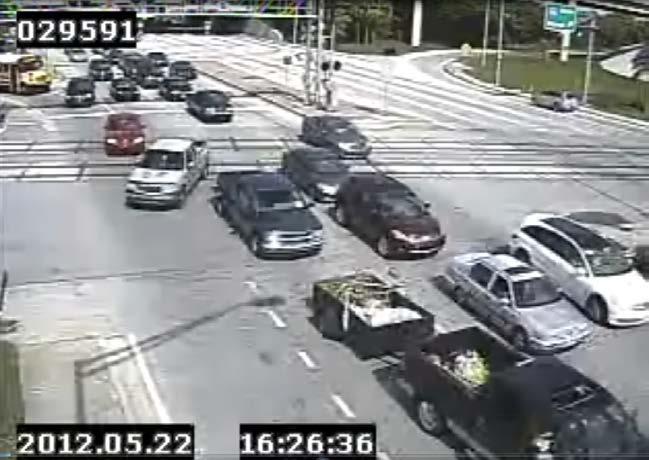
6 Traffic Backed Up Over Tracks Commercial Boulevard, Ft Lauderdale, FL 6

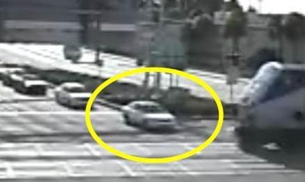
7 Vehicle Stopped within Crossing Commercial Boulevard, Ft Lauderdale, FL 7

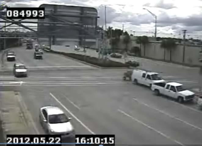
8 Vehicle Turning into Right of Way Commercial Boulevard, Ft Lauderdale, FL 8
9 Examples Commercial Boulevard, Ft Lauderdale, FL 9


10 Dynamic Envelope Pavement Markings Pattern and test location pre-selected by FDOT 10


11 Commercial Boulevard, Ft Lauderdale Pre-installation data May 23-June 5, 2012 Markings Installed week of December 9, 2012 Post-Installation data Jan 6-19,


12 Data Collection Data collected in 2-hour time frames from 7:30-9:30am, 11:00am-1:00pm, and 4:00-6:00pm each day for the daytime condition and 10:00pm-12:00am for the nighttime condition. Recorded 112 hours of data for analysis during each phase (pre- and post-test). Both directions, eastbound and westbound, were recorded and analyzed separately. Allowed for 3-week novelty effect before collecting post-installation data 12
 Zone 2 832 (27.3%) 875 (26.4%) 749 (23.5%) 784 (22.8%) Zone 3 216 (7.1%) 130 (3.9%) 400 (12.6%) 369 (10.7%) Zone 4 105 (3.5%) 70 (2.1%) 112 (3.5%) 78 (2.")
13 Data Analysis Eastbound Traffic Westbound Traffic Zone Pre-Install Post-Install Pre-Install Post-Install Stopped Zone 1 1,890 (62.1%) 2,244 (67.6%) 1,926 (60.4%) 2,209 (64.2%) Zone (27.3%) 875 (26.4%) 749 (23.5%) 784 (22.8%) Zone (7.1%) 130 (3.9%) 400 (12.6%) 369 (10.7%) Zone (3.5%) 70 (2.1%) 112 (3.5%) 78 (2.3%) Total 3,043 3,319 3,187 3,440 13

14 Proportion of Eastbound Vehicles Stopped by Zone * Chi-square test of independence showed a significant difference between the pre- and post-install conditions (p 0.01) 14

15 Proportion of Westbound Vehicles Stopped by Zone * Chi-square test of independence showed a significant difference between the pre- and post-install conditions (p 0.01) 15

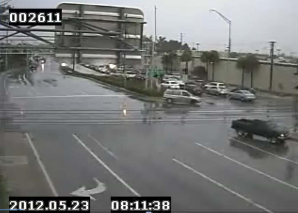
16 Vehicles Stopped within Crossing after Pavement Markings Installation Commercial Boulevard, Ft Lauderdale, FL 16

17 Vehicle Stopped within Crossing after Pavement Markings Installation Commercial Boulevard, Ft Lauderdale, FL 17
18 Findings A 45% reduction in the number of vehicles stopped in Zone 3 (on tracks) eastbound and 15% reduction for westbound after installation An increase in vehicles stopping in Zone 1 (behind the stop line) after installation A reduction in the number of gate violations (both descending and horizontal) after installation Next Steps Draft Report under FRA review Continue collaboration with FDOT and NJDOT on additional pilot installations Additional crossings under consideration in FL One crossing under consideration in NJ 18

19 Marco dasilva General Engineer/Project Manager Highway-Rail Grade Crossing and Trespass Prevention Research Program US DOT RITA Volpe Center Technical Center for Infrastructure Systems and Engineering Systems Safety and Engineering Division, RVT Broadway, Kendall Square Cambridge, MA Office: Cell: Fax:
SUPERSTREETS IN TEXAS. ITS Texas Annual Meeting San Marcos, Texas Session 6A - Operations November 11, 2011
 SUPERSTREETS IN TEXAS ITS Texas Annual Meeting San Marcos, Texas Session 6A - Operations November 11, 2011 1 Superstreet Corridor Location 2 3 US Highway 281 2007 Looking south above Evans Road, pm peak
New Jersey Department of Transportation. Safety Impact Teams. May 22, 2007 Patricia Ott, P. E. Director, Traffic Engineering & Safety
 New Jersey Department of Transportation Safety Impact Teams May 22, 2007 Patricia Ott, P. E. Director, Traffic Engineering & Safety Safe Corridor Legislation Approved July 2003 Double Fines for Motor Vehicle
Safety Corridors a Synthesis. Charlie Nemmers / Derek Vap University of Missouri
 Safety Corridors a Synthesis Charlie Nemmers / Derek Vap University of Missouri 1 Background: Safety Corridors Study Need grew from a four State Safety Summit Funding from Iowa, Kansas, Missouri DOTs and
Orange County Rail-Highway Grade Crossing Safety Enhancement Program. City of San Juan Capistrano April 17, 2012
 Orange County Rail-Highway Grade Crossing Safety Enhancement Program City of San Juan Capistrano April 17, 2012 Orange County Rail-Highway Grade Crossing Safety Enhancement Program (OCX) 52 crossings 8
THE INSTALLATION OF PRE-SIGNALS AT RAILROAD GRADE CROSSINGS
 THE INSTALLATION OF PRE-SIGNALS AT RAILROAD GRADE CROSSINGS Lisa D. Sherman, Kenneth J. Petraglia, P.E. INTRODUCTION Each signalized intersection adjacent to a highway-rail grade crossing presents the
Holland Tunnel Exit in NJ
 Holland Tunnel Exit in NJ Using Operational Changes to Enhance Tunnel Throughput IBTTA Maintenance & Operations Workshop Daniel Jacobs, General Manager Trans. & Revenue May 17, 2016 Holland Tunnel Opened
Pedestrian Issues and Safety Initiatives in Railroad Corridors
 Pedestrian Issues and Safety Initiatives in Railroad Corridors Sponsored by ITE Combined Grade Crossings Committee TENC 102-02 FRA Perspectives on Pedestrian Safety at Grade Crossings Brian F. Gilleran,
Waterford Lakes Small Area Study
 Waterford Lakes Small Area Study Existing Traffic Conditions PREPARED FOR: ORANGE COUNTY PUBLIC WORKS DEPARTMENT TRAFFIC ENGINEERING DIVISION ORLANDO, FLORIDA PREPARED WITH: INWOOD CONSULTING ENGINEERS
Study of the Effects of Buried Pipe Integrity on Roadway Subsidence
 Pipe-RU6558 Study of the Effects of Buried Pipe Integrity on Roadway Subsidence FINAL REPORT October 2005 Submitted by Dr. Husam Najm * Professor Dr. Ali Maher * Professor/Director Dr. Nenad Gucunski *
INNOVATIVE INTERSECTION DESIGN
 INNOVATIVE INTERSECTION DESIGN J. Eddie Valtier, P.E. ELP TP&D Director Introduction Why Do We Need To Start Looking For Innovative Intersection Designs? Congestion is worsening and traffic volumes and
FINAL DESIGN TRAFFIC TECHNICAL MEMORANDUM
 FINAL DESIGN TRAFFIC TECHNICAL MEMORANDUM July 2014 FINAL (SR 43) Project Development and Environment Study From State Road 60 (Adamo Drive) to I-4 (SR 400) Hillsborough County, Florida Work Program Item
Glenwood High School Drivers Education. April 23, 2014
 Glenwood High School Drivers Education April 23, 2014 1 Illinois High-Speed Rail Chicago to St. Louis Program 2 Illinois High-Speed Rail Chicago to St. Louis Program 3 Chicago-St. Louis Corridor» IDOT
FLORIDA DEPARTMENT OF TRANSPORTATION DISTRICT 7 DISTRICT WIDE BICYCLE/PEDESTRIAN ACCESS TO TRANSIT SAFETY ASSESSMENT AND IMPROVEMENT PLAN
 FLORIDA DEPARTMENT OF TRANSPORTATION DISTRICT 7 DISTRICT WIDE BICYCLE/PEDESTRIAN ACCESS TO TRANSIT SAFETY ASSESSMENT AND IMPROVEMENT PLAN TRANSIT SAFETY ASSESSMENT SR 55/US 19 AT 80 TH AVE N DRAFT JUNE
Project Goals and Objectives
 Project Goals and Objectives Goal 1: Goal 2: Goal 3: Transform Coast Highway into a Complete Street that accommodates all roadway users (pedestrians, bicyclists, and autos) Objectives: Improve the pedestrian
THE EFFECTIVENESS OF LOW-COST TRAFFIC CALMING APPLICATIONS APPROPRIATE FOR MAIN STREETS THROUGH RURAL COMMUNITIES
 THE EFFECTIVENESS OF LOW-COST TRAFFIC CALMING APPLICATIONS APPROPRIATE FOR MAIN STREETS THROUGH RURAL COMMUNITIES Eric R. Petersen Civil Engineering (M.S.) Student Iowa State University (515) 223-6534
Driver Education Ch. 4: Safe Driving Rules & Regulations. Ms. Marx
 Driver Education Ch. 4: Safe Driving Rules & Regulations Ms. Marx Speed Control Speed is one of the most common contributing factors of fatal & other types of accidents School zones, business or residential
CAPITOL DRIVE & FOND DU LAC AVENUE INTERSECTION ANALYSIS. Urban Planning 772 SARAH BREGANT, RYAN PETERSON, & MATT WERDERITCH
 CAPITOL DRIVE & FOND DU LAC AVENUE INTERSECTION ANALYSIS Urban Planning 772 SARAH BREGANT, RYAN PETERSON, & MATT WERDERITCH OVERVIEW N 51 ST BOULEVARD N 51 ST BOULEVARD 12,100 44,700 W CAPITOL DRIVE 52,600
DEPARTMENT OF ENVIRONMENTAL SERVICES. North Harrison Street (Lee Highway to Little Falls Road) Comparative Analysis. Prepared for:
 Comparative Analysis. Prepared for:") DEPARTMENT OF ENVIRONMENTAL SERVICES North Harrison Street (Lee Highway to Little Falls Road) Comparative Analysis Prepared for: Arlington County Department of Environmental Services 2100 Clarendon Boulevard,
DEPARTMENT OF ENVIRONMENTAL SERVICES North Harrison Street (Lee Highway to Little Falls Road) Comparative Analysis Prepared for: Arlington County Department of Environmental Services 2100 Clarendon Boulevard,
FM #: ETDM #: 11241
 SR 826/Palmetto Expressway PD&E Study From SR 93/I 75 to the Golden Glades Interchange FM #: 418423 1 22 01 ETDM #: 11241 Agency/ Kick Off Meeting October 27, 2011 2 Location Map From SR 93/I 75 to Golden
Bay to Bay Boulevard Complete Streets Project
 Bay to Bay Boulevard Complete Streets Project Dale Mabry Highway to Bayshore Boulevard February 08, 2018 Photo Source: Tampa Bay Times Alessandra Da Pra Meeting Format Introduction Resurfacing Information
Date: April 4, Project #: Re: A Street/Binford Street Traffic/Intersection Assessment
 To: Peter Cavanaugh General Electric From: David Bohn, PE Ryan White, PE Date: April 4, 217 Project #: 13421. Re: / Traffic/Intersection Assessment Consistent with the Cooperation Agreement between the
A Federal Perspective on Congestion Pricing. Wayne Berman Federal Highway Administration July 8, 2010
 A Federal Perspective on Congestion Pricing Wayne Berman Federal Highway Administration July 8, 2010 Overview Background on Congestion Pricing Benefits and Experiences of Pricing Case Study Miami I-95
ECONOMY PEOPLE ENVIRONMENT
 Report Back on Local Transit Improvements May 29, 2013 ECONOMY PEOPLE ENVIRONMENT Intro Council Requested Report Back Topics Progress on Planning for Broadway Subway False Creek Bridges Local Transit Improvements
Draft North Industrial Area-Wide Traffic Plan
 Summary of North Industrial and Hudson Bay Industrial Recommended Improvements Table 1. Summary of s Item Location 1 2 3 4 5 6 7 8 9 10 11 12 Millar Ave north of 51st St Super 8 Motel back lane 400 Block
May 10, 2013 Meredith Cruz, (561) Palm Beach County Traffic Report May 10 through May 17, 2013
 Palm Beach County Traffic Report May 10 through May 17, 2013") May 10, 2013 Meredith Cruz, (561) 641-6440 mcruz@corradino.com Palm Beach County Traffic Report May 10 through May 17, 2013 Palm Beach County Palm Beach County traffic will be affected this week by ongoing
May 10, 2013 Meredith Cruz, (561) 641-6440 mcruz@corradino.com Palm Beach County Traffic Report May 10 through May 17, 2013 Palm Beach County Palm Beach County traffic will be affected this week by ongoing
Railroad Safety Information for CCIB Conference
 Railroad Safety Information for CCIB Conference Trying to beat the train back in 1917 and still today Walking on RR Tracks in 1926 and still today Riding the side of the train in 1930 and still today
Roundabouts Near At-Grade Railroad Crossings
 Roundabouts Near At-Grade Railroad Crossings May 12, 2008 1,592 Words Alex J. Ariniello LSC Transportation Consultants, Inc., 1889 York Street Denver, CO 80206 Phone: 303-333-1105 FAX: 303-333-1107 email:
Evaluation of LED-Outlined Backplates at Intersections With Light Rail Lines In Houston, Texas
 Evaluation of LED-Outlined Backplates at Intersections With Light Rail Lines In Houston, Texas ITS Texas Annual Meeting, November 2015 Jonathan Tydlacka, P.E. (TTI) Why Are We Here Today? Great forum to
Memorandum 1. INTRODUCTION. To: Cc: From: Denise Marshall Northumberland County
 255 Adelaide Street West Toronto, ON M5H 1X9 www.hdrinc.com File: 4.0 Memorandum To: Cc: From: Denise Marshall Northumberland County Tony Reitmeier HDR Guinevere Ngau HDR Andrew O Connor HDR Date: August
PRESENTATION OUTLINE
 November 8, 2017 PRESENTATION OUTLINE Regional Express Lanes Network Purpose/Benefits of Express Lanes 95 Express Phase 3C Project Video and Overview 95 Express Phase 3C Schedule 2 SOUTH FLORIDA REGIONAL
102 Avenue Corridor Review
 February 26, 2015 102 Avenue Corridor Review Transportation Association of Canada Road Safety Engineering Award Submission for the City of Edmonton Introduction Transportation Association of Canada Road
ICBC invests $1.175 million to help make Surrey, Delta and White Rock s roads safer in 2013
 Date: March 18, 2014 Page: 1 of 8 Media contacts: Michelle Hargrave, 250-979-4642 Lindsay Olsen, 604-982-4759 ICBC invests $1.175 million to help make Surrey, Delta and White Rock s roads safer in 2013
FY STATEWIDE TRANSPORTATION IMPROVEMENT PROGRAM New Jersey Department of Transportation Projects
 ROUTE/ Project ID No. TIP No. Electrical Load Center Replacement - North 04324 04324 This project will provide for the betterment of the existing highway lighting facilities located along Routes 3, 17
Broadway Complete Streets Project
 Broadway Complete Streets Project Megan Johnson, P.E. Associate Civil Engineer James Pangburn, P.E. Consultant Project Manager After the construction of the highway system, Broadway was cut off
I-105 Corridor Sustainability Study (CSS)
") I-105 Corridor Sustainability Study (CSS) Metro Streets and Freeways Subcommittee March 21, 2019 Gary Hamrick Cambridge Systematics, Inc. I-105 CSS Project History & Background Funded by Caltrans Sustainable
I-105 Corridor Sustainability Study (CSS) Metro Streets and Freeways Subcommittee March 21, 2019 Gary Hamrick Cambridge Systematics, Inc. I-105 CSS Project History & Background Funded by Caltrans Sustainable
Pedestrian Road Safety Audit
 Pedestrian Road Safety Audit Middlebrook Road From Father Hurley Boulevard to Waring Station Road December 2017 Montgomery County Department of Transportation Table of Contents 1. Introduction... 1 1.1
Public Opinion, Traffic Performance, the Environment, and Safety After Construction of Double-Lane Roundabouts
 Public Opinion, Traffic Performance, the Environment, and Safety After Construction of Double-Lane Roundabouts TRB 93 rd Annual Meeting Washington, D.C. January 15, 2014 Wen Hu, Ph.D. Intersection crashes
An Application of Signal Detection Theory for Understanding Driver Behavior at Highway-Rail Grade Crossings
 An Application of Signal Detection Theory for Understanding Driver Behavior at Highway-Rail Grade Crossings Michelle Yeh and Jordan Multer United States Department of Transportation Volpe National Transportation
Gary Eddy ATV/Snowmobile Administrator WI DNR
 October 15, 2012 Gary Eddy ATV/Snowmobile Administrator WI DNR gary.eddy@wisconsin.gov 340.01(2g) (2g) "All-terrain vehicle" means an engine-driven device which has a net weight of 900 pounds or less,
Mandan Commission Meeting August 2, 2016 Mandan City Hall
 Mandan-Bismarck Corridor Improvement Study Mandan Commission Meeting August 2, 2016 Mandan City Hall 2014 HDR, Inc., all rights reserved. Mandan Corridors Study Schedule 2015 2016 Study Kick Off August
USDOT Bicycle and Pedestrian Safety Initiative: Safer People and Safer Streets. Barbara McCann, USDOT Office of Policy
 { USDOT Bicycle and Pedestrian Safety Initiative: Safer People and Safer Streets Barbara McCann, USDOT Office of Policy 4 Steps from policy to practice Creating multi-modal streets means: 1. Change Decision-Making
NCHRP Superelevation Criteria for Sharp Horizontal Curves on Steep Grades. Research Team: MRIGlobal Pennsylvania State University
 NCHRP 15-39 Superelevation Criteria for Sharp Horizontal Curves on Steep Grades Research Team: MRIGlobal Pennsylvania State University Objective and Scope Develop superelevation criteria for sharp horizontal
3.9 - Transportation and Traffic
 Transportation and Traffic 3.9 - Transportation and Traffic This section describes the potential transportation and traffic effects of project implementation on the project site and its surrounding area.
CHAPTER 9: SAFETY 9.1 TRAFFIC SAFETY INTERSECTION COLLISIONS
 CHAPTER 9: SAFETY 9.1 TRAFFIC SAFETY Creating a transportation network that is not only efficient but also safe is a key objective of the General Plan and the WBCMP. To assess the current safety conditions
Public Works Committee Meeting Richard E. Mastrangelo Council Chamber November 20, 2017
 Public Works Committee Meeting Richard E. Mastrangelo Council Chamber November 20, 2017 Purpose of Meeting Why are we here? Project Recap/Updates Project Limits/Segments Road Diet Concept Lessons Learned
INTERSECTION CONTROL NOVEMBER 2018
 INTERSECTION CONTROL NOVEMBER 2018 ICE OVERVIEW AGENDA Why ICE? When ICE is Required? Applicability and Process 2 AVAILABLE RESOURCES http://www.fdot.gov/traffic/trafficservices/intersection_operations.shtm
FI N A N C I A L RESOURCER S REVIEW AND UPDATE M I A M I-DADE LO N G R A N G E TRANSPORT T ATION PLAN UPDATE TO THE YE
 Appendix B: Miami-Dade LRTP Cost Feasible Projects (Fully Funded and Partially Funded Projects) Fully Funded Projects Existing County roads O&M $317.9 $316.7 $811.5 Non Motorized set aside $27.9 $24.7
BENNING ROAD & BRIDGES TRANSPORTATION IMPROVEMENTS CRASH DATA AND SAFETY ANALYSIS TECHNICAL MEMORANDUM DRAFT MAY 2016
 BENNING ROAD & BRIDGES TRANSPORTATION IMPROVEMENTS CRASH DATA AND SAFETY ANALYSIS TECHNICAL MEMORANDUM DRAFT MAY 2016 This page left intentionally blank. Table of Contents 1.0 Introduction... 1 1.1 Crash
Northbound San Jose Avenue & I-280 Off-Ramp Road Diet Pilot Project
 Project Overview Fed by a two-lane Interstate-280 (I-280) off-ramp, high vehicular volumes and speeds are longstanding issues along San Jose Avenue. Residents in the surrounding neighborhoods have expressed
BOARD OF COUNTY COMMISSIONERS AGENDA ITEM SUMMARY
 7B BOARD OF COUNTY COMMISSIONERS AGENDA ITEM SUMMARY PLACEMENT: REQUESTS AND PRESENTATIONS PRESET: TITLE: FLORIDA DEPARTMENT OF TRANSPORTATION (FDOT) PRESENTATION RECONSTRUCTION OF SR-76 (SW KANNER HIGHWAY)
CHAPTER 1 STANDARD PRACTICES
 CHAPTER 1 STANDARD PRACTICES OBJECTIVES 1) Functions and Limitations 2) Standardization of Application 3) Materials 4) Colors 5) Widths and Patterns of Longitudinal Pavement Marking Lines 6) General Principles
ATTACHMENT NO. 11. RRLRT No. 2. Railroad / Light Rail Transit Technical Committee TECHNICAL COMMITTEE: Busway Grade Crossings STATUS/DATE OF ACTION
 ATTACHMENT NO. 11 RRLRT No. 2 TECHNICAL COMMITTEE: TOPIC: Railroad / Light Rail Transit Technical Committee Busway Grade Crossings STATUS/DATE OF ACTION RRLRT TC Draft: 06/23/2011 RRLRT TC Approval: 06/27/2014
Design Traffic Technical Memorandum
 State Road 7 Extension PD&E Study Design Traffic Technical Memorandum Palm Beach County, FL October 2010 State Road 7 Extension PD&E Study Design Traffic Technical Memorandum Palm Beach County, FL Prepared
Description: Widen I-64 to 6 lanes from I-265 to the KY 53 interchange in Shelby County.
 I-64 KIPDA ID # 350 Project Type: ROADWAY CAPACITY Description: Widen I-64 to 6 lanes from I-265 to the KY 53 interchange in Shelby County. Purpose: Project will improve capacity and address safety concerns.
Emerging Methods for Evaluating Transportation Systems Multimodal LOS and Highway Safety Manual
 Emerging Methods for Evaluating Transportation Systems Multimodal LOS and Highway Safety Manual November 8, 2012 Lake Merritt Tower in Oakland Transportation Education Series 1 Presenters Mark Bowman,
Pedestrian Safety: A Federal Perspective. Emmett McDevitt Transportation Safety Engineer September 28, 2010
 Pedestrian Safety: A Federal Perspective Emmett McDevitt Transportation Safety Engineer September 28, 2010 Pedestrian Fatalities by Year in US (1997-2009) 6,000 5,000 4,000 3,000 2,000 1,000 0 1997 1998
Railroad-Highway Grade Crossing Analysis for Corridor Planning Projects
 Railroad-Highway Grade Crossing Analysis for Corridor Planning Projects Word Count: 4,305 Submission Date: August 1, 2015 Author: Adriana Rodriguez, E.I Assistant Engineer Parsons Brinckerhoff 1420 South
About the Wilmington Downtown Circulation Study
 About the Wilmington Downtown Circulation Study Part of the Wilmington i Initiatives partnership Wilmington Area Planning Council City of Wilmington Delaware Department of Transportation Delaware Transit
Pavement Markings (1 of 3)
") Pavement Markings (1 of 3) DESCRIPTION AND DEFINITION Disadvantages Relatively high cost (over typical Crash reduction as yet unknown painted edge line) No tactile effect The STOP AHEAD pavement marking
Pavement Markings (1 of 3) DESCRIPTION AND DEFINITION Disadvantages Relatively high cost (over typical Crash reduction as yet unknown painted edge line) No tactile effect The STOP AHEAD pavement marking
TRAFFIC IMPACT STUDY And A TRAFFIC SIGNAL WARRANT ANALYSIS FOR A SENIOR LIVING AND APARTMENT DEVELOPMENT
 TRAFFIC IMPACT STUDY And A TRAFFIC SIGNAL WARRANT ANALYSIS FOR A SENIOR LIVING AND APARTMENT DEVELOPMENT DEERFIELD TOWNSHIP, WARREN COUNTY, OHIO Nantucket Circle and Montgomery Road () Prepared for: ODLE
February 2018 HIGHWAY 316 IMPROVEMENTS PROJECT
 February 2018 HIGHWAY 316 IMPROVEMENTS PROJECT Agenda 1 2 3 4 5 A Message from the City Project Area Traffic Conditions Pedestrian/Bicycle Comfort & Safety Next Steps Q&A City of Hastings Supports a study
FY 2004 TRANSPORTATION CAPITAL PROGRAM New Jersey Department of Transportation Projects
 Avenue P Bridge 03315 This project will address potential construction in the vicinity of the Avenue P Bridge. SPONSOR: City of Newark Bridge Preservation - Local Bridges NJTPA 288 DES STATE $400,000 CARGOMATE
NY Route 5 Comprehensive Pedestrian Safety Study: A Corridor Perspective CDTC Planning Committee. January 7, 2015
 NY Route 5 Comprehensive Pedestrian Safety Study: A Corridor Perspective CDTC Planning Committee January 7, 2015 Project Objective Study Scope: Perform an analysis of pedestrian related accidents, An engineering
Completing the Vision
 Villas of Positano Completing the Vision North A1A Lane Reconfiguration N. Surf Rd. Redirection of Traffic Margaritaville Resort March 4, 2014 1 Completing The Vision Project Limits Hollywood Blvd. to
Meeting Date 10/18/2005 Type Internal Team Progress Other Date of Issuance 10/25/05. Coordination See attached sign-in sheet
 Meeting Date 10/18/2005 Type Internal Team Progress Other Date of Issuance 10/25/05 Coordination Attendees See attached sign-in sheet Location Great Hall, Holland Tunnel Route 139 Contract 2 PANYNJ Coordination
MUTCD Part 6G: Type of Temporary Traffic Control Zone Activities
 MUTCD Part 6G: Type of Temporary Traffic Control Zone Activities 6G.01 Typical Applications Each temporary traffic control (TTC) zone is different. Many variables, such as location of work, highway type,
Appendix C. NORTH METRO STATION AREA TRAFFIC IMPACT STATEMENT 88th Avenue Station
 Appendix C NORTH METRO STATION AREA TRAFFIC IMPACT STATEMENT 88th Avenue Station Prepared for: Regional Transportation Department and URS Corporation as part of the North Metro EIS David Evans and Associates,
IH 20 RANGER HILL PUBLIC MEETING
 IH 20 RANGER HILL PUBLIC MEETING AUGUST 25, 2015 IH 20, Eastland County, TX CSJ 0007-06-084 IH 20 from 3.5 mi. East of LP 254 to SH 16 (Ranger Hill) August 25, 2015 Agenda Introductions Purpose of the
CITY OF ENCINITAS CITY COUNCIL AGENDA REPORT Meeting Date: June 26, 2013
 CITY OF ENCINITAS CITY COUNCIL AGENDA REPORT Meeting Date: June 26, 2013 TO: VIA: FROM: City Council Gus Vina, City Manager Glenn Pruim, Director of Engineering and Public Works Rob Blough, City Traffic
Effects of Traffic Signal Retiming on Safety. Peter J. Yauch, P.E., PTOE Program Manager, TSM&O Albeck Gerken, Inc.
 Effects of Traffic Signal Retiming on Safety Peter J. Yauch, P.E., PTOE Program Manager, TSM&O Albeck Gerken, Inc. Introduction It has long been recognized that traffic signal timing can have an impact
F L E T C H E R A V E N U E
 Jan. 29, 2014 Introduction F L E T C H E R A V E N U E FDOT Local Agency Program (LAP) Project FPN: 428214-1-58-01 CIP 63090 Hillsborough County, Traffic Engineering, PWD Stake holders and partners are
APPENDIX A: Complete Streets Checklist DRAFT NOVEMBER 2016
 APPENDIX A: Complete Streets Checklist DRAFT NOVEMBER 2016 Complete Streets Checklist MetroPlan Orlando s Complete Streets Checklist is an internal planning tool for staff to further implementation of
Iowa Highway 58 Corridor Improvement Study
 1 Iowa Highway 58 Corridor Improvement Study Public Informational Meeting May 6, 2014 2 Welcome and Introductions Randy Lorenzen, City of Cedar Falls Engineer 3 Outline of Presentation Review of Project
95 Express Annual Operations Report: Fiscal Year
 95 Express Annual Operations Report: Fiscal Year 2014-2015 General The 95 Express Program completed its sixth full Fiscal Year of operations in June 2015. For the FDOT, its Fiscal Year (FY) is from July
Speed Control & Limits
 Speed Control & Limits Exceeding the speed limit is a common contributing factor of fatal and other types of accidents. *25 mph* School zones, business or residential districts *55 mph* Certain state highways
HIGHBURY AVENUE/HAMILTON ROAD INTERSECTION IMPROVEMENTS PUBLIC INFORMATION CENTRE 1 MAY 14, 2015
 HIGHBURY AVENUE/HAMILTON ROAD INTERSECTION IMPROVEMENTS Municipal Class Environmental Assessment PUBLIC INFORMATION CENTRE 1 MAY 14, 2015 ACCESSIBILITY Under the Accessibility Standards 2015 for Customer
Engineering Countermeasures for Transportation Safety. Adam Larsen Safety Engineer Federal Highway Administration
 Engineering Countermeasures for Transportation Safety Adam Larsen Safety Engineer Federal Highway Administration 360-619-7751 Adam.Larsen@DOT.GOV Countermeasure Selection Resources Manual for Selecting
Parks Highway: MP Lucus Road to Big Lake Road
 2 Purpose and Need 2.1 Corridor History The Parks Highway is a 324-mile long Rural Interstate Highway that extends from its intersection with the Glenn Highway north to Fairbanks, Alaska. The Parks Highway
Existing Conditions. Date: April 16 th, Dan Holderness; Coralville City Engineer Scott Larson; Coralville Assistant City Engineer
 Date: April 16 th, 2015 To: From: Re: Dan Holderness; Coralville City Engineer Scott Larson; Coralville Assistant City Engineer Darian Nagle-Gamm, Traffic Engineering Planner Highway 6 (2 nd Street) /
Intersection Design. Leah Ness, Craig Hardy and Eric Sorensen
 Intersection Design Leah Ness, Craig Hardy and Eric Sorensen OVERVIEW TYPES OF INTERSECTIONS SCOPING COORDINATION INTERSECTION EVALUATION HORIZONTAL AND VERTICAL LAYOUTS DESIGN COORDINATION CONSTRUCTION
Improving Cyclist Safety at the Dundas Street West and Sterling Road Intersection
 STAFF REPORT ACTION REQUIRED Improving Cyclist Safety at the Dundas Street West and Sterling Road Intersection Date: August 17, 2012 To: From: Wards: Reference Number: Public Works and Infrastructure Committee
D.13 Transportation and Traffic
 This section addresses transportation and traffic issues and impacts related to the Proposed Project. Section D.13.1 provides a description of the affected environment for the Proposed Project. Applicable
 http://www.itarda.or.jp/english/info36/36top.html Page 1 of 2 Introduction It is difficult to understand how someone could end up driving in the wrong direction on the highway. However, 1 in 300 accidents
History Recent Problems Alternative Routes
 History Recent Problems Alternative Routes Built in 1936 Length: 8.4 miles Made up of two suspension bridges Meet in the middle of the San Francisco Bay at Yerba Buena Island Double-deck bridge Average
 NO PARKING ZONE, YELLOW CURB (OPTIONAL) Z 8 20 MIN. 8 Z (SEE SHEET 2) 4" WHITE "X" (TYP.),(OPTIONAL) TYPE I NO PARKING ZONE, YELLOW CURB (OPTIONAL) Z 8 20 20 ALL SPACES 22 MIN., 26 MAX. EACH Z TYPE II
TRAFFIC IMPACT ANALYSIS
 TRAFFIC IMPACT ANALYSIS FOR THE CHAMPAIGN UNIT#4 SCHOOL DISTRICT PROPOSED HIGH SCHOOL (SPALDING PARK SITE) IN THE CITY OF CHAMPAIGN Final Report Champaign Urbana Urbanized Area Transportation Study 6/24/2014
Offset Single Point Interchange I-25 at Rio Bravo Boulevard Albuquerque, New Mexico
 Offset Single Point Interchange I-25 at Rio Bravo Boulevard Albuquerque, New Mexico INSTITUTE OF TRANSPORTATION ENGINEERS 2016 WESTERN DISTRICT MEETING JULY 11, 2016 7/11/2016 1 Project Vicinity Map 7/11/2016
4. TRAIL DESIGN GUIDELINES
 Trail Design Guidelines 4. TRAIL DESIGN GUIDELINES This chapter provides specific design guidelines for the Humboldt Bay Trail that are consistent with the guidelines currently observed in California and
Meeting Schedule 7:00-7:15 Open House 7:15-7:45 Existing Conditions/Short-Term Improvements Study Presentation 7:45-8:00 Q&A Session 8:00-8:10
 Meeting Schedule 7:00-7:15 Open House 7:15-7:45 Existing Conditions/Short-Term Improvements Study Presentation 7:45-8:00 Q&A Session 8:00-8:10 Long-Term Study Presentation 8:10-8:40 Table Discussions 8:40-9:00
Intersection Traffic Control Feasibility Study
 Intersection Traffic Control Feasibility Study CSAH 9 at CSAH 60 (185th Avenue) Prepared For: Dakota County Transportation Department Western Service Center 14955 Galaxie Avenue, 3rd Floor Apple Valley,
Transportation Planning Division
 Transportation Planning Division Presentation Outline Study Tasks Recap of Previous Meetings Data Collected Focus Areas within Study Limits Design Principles Tool Box Recommended Concepts Schedule Moving
Staunton. Transportation Plan. Transportation Planning Division. Virginia Department of Transportation
 2020 Transportation Plan Developed for the Transportation Planning Division of the Virginia Department of Transportation in cooperation with the U.S. Department of Transportation, Federal Highway Administration
What are Managed Lanes?
 Express Lanes What are Managed Lanes? Highway facilities or a set of lanes where operational strategies are proactively implemented and managed in response to changing conditions. http://ops.fhwa.dot.gov/freewaymgmt/managedlanesvideo/index.htm
TRAFFIC CONTROL DEVICES ON EDGEWATER BOULEVARD AT PORT ROYAL AVENUE (NORTH)
") Attachment 2 DATE: August 6, 2012 TO: VIA: FROM: SUBJECT: Mayor and Members of the City Council James C. Hardy, City Manager Ramon Towne, Director of Public Works Leah Edwards, Assistant Engineer TRAFFIC
Attachment 2 DATE: August 6, 2012 TO: VIA: FROM: SUBJECT: Mayor and Members of the City Council James C. Hardy, City Manager Ramon Towne, Director of Public Works Leah Edwards, Assistant Engineer TRAFFIC
FDOT Treasure Coast Traffic Report
 July 6, 2018 Barbara Kelleher, 954 777 4090 Barbara.Kelleher@dot.state.fl.us FDOT Treasure Coast Traffic Report July 6 through July 13, 2018 TREASURE COAST Construction and maintenance related lane closures
City of San Diego Vision Zero Draft Strategic Plan FY 2017
 City of San Diego Vision Zero Draft Strategic Plan FY 2017 Engineering Objective: To develop and implement a strategy that employs best planning, design and engineering practices. Background: Over the
Mayor s Pedestrian Advisory Council. Wednesday, February 15
 Mayor s Pedestrian Advisory Council Wednesday, February 15 Annual Pedestrian Fatalities 2005-2016 Year-End Pedestrian Fatalities, 2016 (CPD): 44 Year-End Pedestrian Fatalities, 2015 (CPD): 46 Year-End
PEDESTRIAN SAFETY STUDY
 PEDESTRIAN SAFETY STUDY SR 699 (BLIND PASS RD/GULF BLVD) FROM 93 RD AVENUE TO PINELLAS BAYWAY PINELLAS COUNTY SECTION NO.: 15100 MILEPOST: 0.111 3.569 STUDY LIMITS Prepared For: Florida Department of Transportation
Now Let s Think Systemic
 Now Let s Think Systemic Remote Rural County Use of the Highway Safety Improvement Program TRINITY COUNTY DEPARTMENT OF TRANSPORTATION Richard Tippett Director MEET TRINITY COUNTY 3,208 square miles 13,786
Access Management Benefits & Techniques. Access Management Workshop June 2, 2006
 Access Management Benefits & Techniques Access Management Workshop June 2, 2006 1 Benefits of Access Management Safety As access density increases, crash rates increase Increasing the density of access