Project Goals and Objectives
|
|
|
- Lauren Haynes
- 6 years ago
- Views:
Transcription


1 Project Goals and Objectives Goal 1: Goal 2: Goal 3: Transform Coast Highway into a Complete Street that accommodates all roadway users (pedestrians, bicyclists, and autos) Objectives: Improve the pedestrian environment Provide a continuous striped bicycle lane Implement traffic calming measures to reduce traffic intrusion to adjacent neighborhoods Improve safety for all roadway users Objectives: Slow traffic speeds and improve traffic flow Implement roundabouts in place of traffic signals where feasible to reduce auto and pedestrian conflicts at intersections Add new mid-block pedestrian crossing opportunities between major intersections to facilitate pedestrian crossing of the roadway Facilitate implementation of the Coast Highway Vision and Strategic Plan Objectives: Improve the Coast Highway streetscape to encourage new development or redevelopment of underutilized parcels Maintain on-street parking supply corridor-wide and increase supply where possible to support new land uses


2 Examples of Similar Street Transformations La Jolla Blvd La Jolla, CA (Bird Rock) Yucaipa Boulevard Yucaipa, CA (Uptown) Converted from four lanes to two lanes with roundabouts Converted from four lanes to two lanes with roundabouts Accommodates corridor traffic of ~ 20,000 vehicles per day 22% increase in taxable sales for Uptown businesses 2 years after implementation Average vehicle speeds dropped from mph to mph 58% reduction in traffic collisions in 3 years after implementation 20-25% increase in taxable sales for corridor businesses 2 years after implementation


3 Areas of & Proposed s On Coast Highway Mission Ave SR 76 Coast Highway Vista Way Coast Highway Seagaze Dr Coast Highway SR-76: Poor level of service with signal Mission/Seagaze: Heavy southbound left turn volume Vista Way: Heavy southbound/ westbound left turn volume Provide a two-lane roundabout s Provide additional travel lanes and southbound left turn at Seagaze Drive Maintain traffic signals s Maintain through lanes and exclusive left turn pockets Maintain traffic signal


 Preclude left turns from Tremont to Oceanside Traffic calming")
4 Areas of & Proposed s Off Coast Highway Corridor Tremont St Ditmar St Pier View Way Horne St Wisconsin Ave Oceanside Pier View/Horne Wisconsin/Ditmar Oceanside/Tremont Permit dual eastbound right turns to Horne Evaluate mini-roundabout or other traffic calming (bulls outs, raised crosswalks, etc.) Preclude left turns from Tremont to Oceanside Traffic calming measures such as mini-roundabout


5 Areas of & Proposed s Off Coast Highway Corridor Steward St Broadway St Cassidy St Ditmar St Vista Way Horne St Lincoln St Alvarado St Nevada St Freeman St Broadway/Cassidy Vista/Freeman, Ditmar, Stewart s Install 4-way stop Consider traffic signal at Ditmar and preclude left turns from Freeman and Stewart Consider mini-roundabout

6 Roundabout Conceptual Design Examples

7 Roundabout Conceptual Design Examples


8 Benefits of Roundabouts Driver Safety: Recent studies show reductions of ~37 percent in total crashes and ~75 percent in injury crashes at intersections that have been converted to roundabouts. 32 Conflict Points Pedestrian Safety: Due to the reduction of vehicle speeds in and around the intersection, roundabouts can improve pedestrian crossing opportunities. Additionally, the splitter island refuge area provides the ability for pedestrians to focus on one traffic stream at a time while crossing. Efficiency: Roundabouts typically have lower overall delay than signalized and all-way 8 Conflict Points stop-controlled intersections. The delay reduction is often most significant during nonpeak traffic periods (22 hours of the day). Environment: Roundabouts reduce traffic-related noise and air quality impacts and fuel consumption significantly by reducing the number of acceleration/deceleration cycles and the time spent idling. Traffic Calming: Roundabouts can have traffic calming effects on streets by reducing vehicle speeds. Operations and Maintenance Costs: A roundabout typically has lower operating and maintenance costs than a traffic signal due to the lack of technical hardware, signal timing equipment, and electricity needs. Roundabouts also provide substantial cost savings to society due to the reduction in crashes, particularly fatal and injury crashes, over their service life.
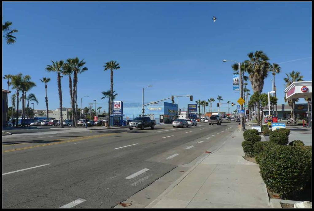
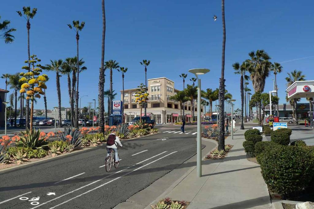
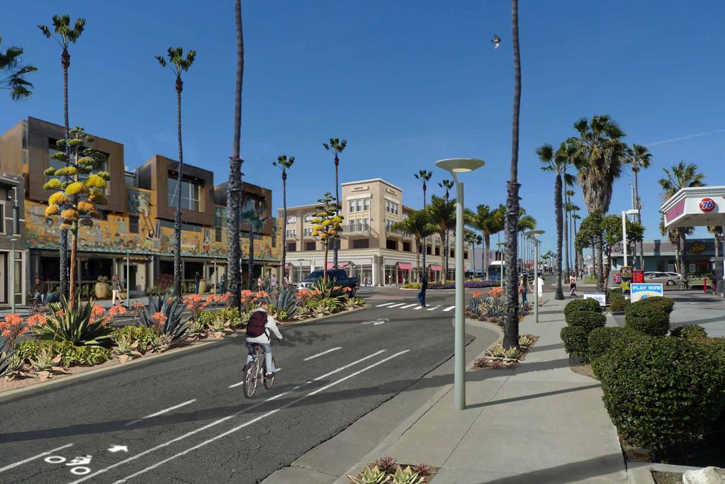
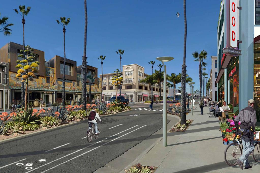
9 Coast Highway/Oceanside Boulevard Visual Simulation
David DiPierro, John Amberson. Steering Committee Meeting #4 Overview
 IBI GROUP 18401 Von Karman Avenue Suite 110 Irvine CA 92612 USA tel 949 833 5588 fax 949 833 5511 ibigroup.com Memorandum To/Attention Steering Committee Members Date February 17, 2016 From IBI Group Project
Intersection Improvement: Sturgeon Road, Silver Avenue and Murray Park Road Roundabout. Welcome. Public Information Session
 Intersection Improvement: 1 Welcome WHY IS AN INTERSECTION IMPROVEMENT NEEDED? 2 Traffic volumes for Sturgeon Road, Silver Avenue and Murray Park Road exceed the capacity of the existing 4-way stop controlled
Summary: Mercer County Princeton Avenue & Spruce Street Study January 2009
 Summary: Several recent studies have assessed potential development and redevelopment opportunities in the Mercer Crossing area of Trenton, Ewing, and Lawrence. This Princeton Avenue and Spruce Street
ROUNDABOUTS. Improving Safety and Efficiency. SR83 & Smithville Western Rd. Joel Montgomery, PE Director of Administration
 ROUNDABOUTS Improving Safety and Efficiency SR83 & Smithville Western Rd. Joel Montgomery, PE Director of Administration The Ohio Department of Transportation District 3 906 North Clark Ave. Ashland, OH
Project Goal and Description. Why Broadway? Broadway SFMTA.COM/BROADWAY. The goal of the Broadway Safety Improvement
 PROJECT OVERVIEW Project Goal and Description The goal of the Broadway Safety Improvement d St Van Ness Ave Project is to improve safety and comfort for all who Franklin St Hyde St Octavia St Gough St
Mission Bay Loop (MBL) Public Meeting
 Public Meeting") Mission Bay Loop (MBL) Public Meeting La Scuola Internazionale di San Francisco, November 18, 2014 Frequently Asked Questions 1. When would construction have to start before the SFMTA loses TIGER funds?
Mission Bay Loop (MBL) Public Meeting La Scuola Internazionale di San Francisco, November 18, 2014 Frequently Asked Questions 1. When would construction have to start before the SFMTA loses TIGER funds?
Princeton Avenue and Spruce Street Transportation and Site Access Enhancements Project
 Princeton Avenue and Spruce Street Transportation and Site Access Enhancements Project Mercer County Planning Division AECOM Transportation (formerly DMJM Harris) January 29, 2009 Agenda Project Status
Road Diets and Roundabouts
 Road Diets and Roundabouts Paul Zykofsky, AICP Local Government Commission Sacramento, CA Classic Road Diet 4 to 3 lanes San Antonio TX On-street parking Median Bike Lanes Center Turn-Lane Seattle WA Road
Street Design Workshop. Existing cross section Traffic volumes Examine adjacent land uses You design future improvements
 Street Design Workshop Existing cross section Traffic volumes Examine adjacent land uses You design future improvements Primary Tools for Street Redesign Road diets Bike lanes Cycle tracks Trails Crosswalks
Pedestrian Safety at Roundabouts. Presentation to the Howard-Suamico School Board November 26, 2007
 Pedestrian Safety at Roundabouts Presentation to the Howard-Suamico School Board November 26, 2007 Roundabouts that have replaced stop signs and traffic signals have reduced the number and severity of
1 st and 2 nd Street Couplet FAQ s
 1 st and 2 nd Street Couplet FAQ s Q. Will the proposed roundabout at Flume/2nd/1 st Streets affect access to businesses nearby?... 2 Q. What if the project isn t received well by the community after construction?...
Broadway Complete Streets Project
 Broadway Complete Streets Project Megan Johnson, P.E. Associate Civil Engineer James Pangburn, P.E. Consultant Project Manager After the construction of the highway system, Broadway was cut off
Tonight is for you. Learn everything you can. Share all your ideas.
 Strathcona Neighbourhood Renewal Draft Concept Design Tonight is for you. Learn everything you can. Share all your ideas. What is Neighbourhood Renewal? Creating a design with you for your neighbourhood.
CITY OF OAKLAND. 27th Street Bikeway Feasibility and Design. Final Report (v3) March 23, Kimley-Horn and Associates, Inc.
 March 23, Kimley-Horn and Associates, Inc.") CITY OF OAKLAND 27th Street Bikeway Feasibility and Design Final Report (v3) March 23, 2007 PREPARED BY: Kimley-Horn and Associates, Inc. Table of Contents 1. Introduction 3 2. 27 th Street/Bay Place Corridor
CITY OF OAKLAND 27th Street Bikeway Feasibility and Design Final Report (v3) March 23, 2007 PREPARED BY: Kimley-Horn and Associates, Inc. Table of Contents 1. Introduction 3 2. 27 th Street/Bay Place Corridor
Clybourn Ave. Protected Bike Lane Study Halsted St. to Division St.
 Clybourn Ave. Protected Bike Lane Study Halsted St. to Division St. Nathan Roseberry, Senior Engineer Pam Broviak, Project Manager July 24, 2014 Agenda Project Goals Existing Roadway Conditions Traffic
Roundabout Feasibility Memorandum
 Roundabout Feasibility Memorandum To From Gwen Pipkin Bill Howell Date June 18, 2013 Subject Roundabout Feasibility Study SR 29 PD&E Study From Oil Well Road to SR 82 Collier County, FL FPID 417540-1-22-01
DEPARTMENT OF ENVIRONMENTAL SERVICES. North Harrison Street (Lee Highway to Little Falls Road) Comparative Analysis. Prepared for:
 Comparative Analysis. Prepared for:") DEPARTMENT OF ENVIRONMENTAL SERVICES North Harrison Street (Lee Highway to Little Falls Road) Comparative Analysis Prepared for: Arlington County Department of Environmental Services 2100 Clarendon Boulevard,
DEPARTMENT OF ENVIRONMENTAL SERVICES North Harrison Street (Lee Highway to Little Falls Road) Comparative Analysis Prepared for: Arlington County Department of Environmental Services 2100 Clarendon Boulevard,
Roundabouts are good for business
 Roundabouts are good for business What is a roundabout Rules 0f Roundabouts 1. Slow down when approaching a roundabout 2. Yield to vehicles in the roundabout 3. When clear, proceed right into the roundabout
Lessons Learned from Cycle Tracks (Class IV Bikeways) Design Practice
 Design Practice") Lessons Learned from Cycle Tracks (Class IV Bikeways) Design Practice By: Min Zhou, P.E., Principal/Vice President KOA Corporation 1 What is a Cycle Track (Class IV) TYPICAL BIKEWAY CLASSIFICATION CLASS
Lessons Learned from Cycle Tracks (Class IV Bikeways) Design Practice By: Min Zhou, P.E., Principal/Vice President KOA Corporation 1 What is a Cycle Track (Class IV) TYPICAL BIKEWAY CLASSIFICATION CLASS
Public Information Centre
 WELCOME Public Information Centre Father Tobin Road Lougheed Middle School - Library Wednesday November 7, 2012 7:00 p.m.to 9:00 p.m. Please sign in Neighbourhood Traffic Calming Guide Background The City
Access Management Regulations and Standards
 Access Management Regulations and Standards Efficient highway operation Reasonable property access Concept of Access Management The way to manage access to land development while simultaneously preserving
SAN FRANCISCO MUNICIPAL TRANSPORTATION AGENCY
 THIS PRINT COVERS CALENDAR ITEM NO. : 10.2 DIVISION: Sustainable Streets BRIEF DESCRIPTION: SAN FRANCISCO MUNICIPAL TRANSPORTATION AGENCY Adopting Conceptual Proposal for Streetscape Improvements to Broadway,
Simulation Analysis of Intersection Treatments for Cycle Tracks
 Abstract Simulation Analysis of Intersection Treatments for Cycle Tracks The increased use of cycle tracks also known as protected bike lanes has led to investigations of how to accommodate them at intersections.
INNOVATIVE INTERSECTION DESIGN
 INNOVATIVE INTERSECTION DESIGN J. Eddie Valtier, P.E. ELP TP&D Director Introduction Why Do We Need To Start Looking For Innovative Intersection Designs? Congestion is worsening and traffic volumes and
Existing Conditions. Date: April 16 th, Dan Holderness; Coralville City Engineer Scott Larson; Coralville Assistant City Engineer
 Date: April 16 th, 2015 To: From: Re: Dan Holderness; Coralville City Engineer Scott Larson; Coralville Assistant City Engineer Darian Nagle-Gamm, Traffic Engineering Planner Highway 6 (2 nd Street) /
UPTOWN REGIONAL BIKE CORRIDORS PROJECT SAN DIEGO ASSOCIATION OF GOVERNMENTS
 UPTOWN REGIONAL BIKE CORRIDORS PROJECT SAN DIEGO ASSOCIATION OF GOVERNMENTS SUMMARY REPORT: COMMUNITY UPDATE MEETING February 6, 2014 6 8:30 p.m. Roosevelt Middle School Library 3366 Park Blvd, San Diego
133 rd Street and 132 nd /Hemlock Street 132 nd Street and Foster Street MINI ROUNDABOUTS. Overland Park, Kansas
 133 rd Street and 132 nd /Hemlock Street 132 nd Street and Foster Street MINI ROUNDABOUTS Overland Park, Kansas September 1, 2017 TABLE OF CONTENTS 1. INTRODUCTION... 1 2. LITERATURE REVIEW... 1 3. CONCEPT
CITY OF LOS ANGELES INTER-DEPARTMENTAL MEMORANDUM
 CITY OF LOS ANGELES INTER-DEPARTMENTAL MEMORANDUM Date: April 1, 219 To: Honorable City Council c/o City Clerk, Room 395, City Hall Attention: Honorable Mike Bonin, Chair, Transportation Committee From:
A-1 Arcadia with Signal
 A-1 Arcadia with Signal Dakota St Variation: Half 3/4 with westbound left at Main 4 - Fewer downtown access points - Less efficient traffic operations - Highest project costs vanston. ote: traffic volumes
Completing the Vision
 Villas of Positano Completing the Vision North A1A Lane Reconfiguration N. Surf Rd. Redirection of Traffic Margaritaville Resort March 4, 2014 1 Completing The Vision Project Limits Hollywood Blvd. to
Complete Street Analysis of a Road Diet: Orange Grove Boulevard, Pasadena, CA
 Complete Street Analysis of a Road Diet: Orange Grove Boulevard, Pasadena, CA Aaron Elias, Bill Cisco Abstract As part of evaluating the feasibility of a road diet on Orange Grove Boulevard in Pasadena,
Giles Run Connector Road
 Giles Run Connector Road Laurel Hill Adaptive Reuse Area to Laurel Crest Drive South County Federation Meeting June 14, 2016 History Connector road included in the Laurel Hill Comprehensive Plan amendment
Dr. M.L. King, Jr. Street North Complete Streets Resurfacing Opportunities HOUSING, LAND USE, AND TRANSPORTATION COMMITTEE MARCH 22, 2018
 Dr. M.L. King, Jr. Street North Complete Streets Resurfacing Opportunities HOUSING, LAND USE, AND TRANSPORTATION COMMITTEE MARCH 22, 2018 What s Happening The City plans to mill and resurface Dr. M.L.
Bay to Bay Boulevard Complete Streets Project
 Bay to Bay Boulevard Complete Streets Project Dale Mabry Highway to Bayshore Boulevard February 08, 2018 Photo Source: Tampa Bay Times Alessandra Da Pra Meeting Format Introduction Resurfacing Information
Road Diets FDOT Process
 Florida Department of TRANSPORTATION Road Diets FDOT Process Humberto Castillero, PE, PTOE Roadway Design Office Purpose of Guide Develop a statewide lane elimination review process Balance state & local
The Case for Roundabouts:
 The Case for Roundabouts: What the Research Shows Annual Meeting AASHTO Subcommittee on Design Orlando, FL, June 14, 2006 Susan Ferguson, PH.D. Delays at red lights getting longer Wall Street Journal,
Chapter 4 TOOLBOX AND SAMPLE BIKE BOULEVARD LAYOUT
 Chapter 4 TOOLBOX AND SAMPLE BIKE BOULEVARD LAYOUT OVERVIEW This chapter describes a cohesive set of strategies to create a bicycle boulevard, namely to make streets safer and more efficient for bicycle
Intersection Design. Leah Ness, Craig Hardy and Eric Sorensen
 Intersection Design Leah Ness, Craig Hardy and Eric Sorensen OVERVIEW TYPES OF INTERSECTIONS SCOPING COORDINATION INTERSECTION EVALUATION HORIZONTAL AND VERTICAL LAYOUTS DESIGN COORDINATION CONSTRUCTION
6.4 RECOMMENDED IMPROVEMENTS
 6.4 RECOMMENDED IMPROVEMENTS 6.4.1 Williston Road Recommendations While all alternatives would be an improvement over existing conditions, Alternative 3B is recommended over the others because it provides
CAPITOL DRIVE & FOND DU LAC AVENUE INTERSECTION ANALYSIS. Urban Planning 772 SARAH BREGANT, RYAN PETERSON, & MATT WERDERITCH
 CAPITOL DRIVE & FOND DU LAC AVENUE INTERSECTION ANALYSIS Urban Planning 772 SARAH BREGANT, RYAN PETERSON, & MATT WERDERITCH OVERVIEW N 51 ST BOULEVARD N 51 ST BOULEVARD 12,100 44,700 W CAPITOL DRIVE 52,600
Roundabouts. By: Nezamuddin, Valparaiso University. February 19, 2015
 Roundabouts By: Nezamuddin, Valparaiso University February 19, 2015 Outline 1. Background on Roundabouts 2. Silhavy Rd. Corridor Improvement Project in Valparaiso, IN 3. 5-points Roundabout in Valparaiso,
SUPERSTREETS IN TEXAS. ITS Texas Annual Meeting San Marcos, Texas Session 6A - Operations November 11, 2011
 SUPERSTREETS IN TEXAS ITS Texas Annual Meeting San Marcos, Texas Session 6A - Operations November 11, 2011 1 Superstreet Corridor Location 2 3 US Highway 281 2007 Looking south above Evans Road, pm peak
2014/2015 BIKE ROUTE PLAN 83 AVENUE PROTECTED BIKE LANE
 About the Project 2014/2015 BIKE ROUTE PLAN The City of Edmonton is planning a major bike route on the south side of Edmonton. This bike route is one part of a plan to provide citizens with transportation
CTDOT Pedestrian and Bicycle Safety Initiatives
 CTDOT Pedestrian and Bicycle Safety Initiatives 2017 Northeast Transportation Safety Conference Mark F. Carlino, P.E. Traffic Engineering Division Chief Bureau of Engineering and Construction Connecticut
Agenda. Introduction to Roundabouts. Introduction to Roundabouts. Introduction to Roundabouts 6/6/2018
 PROPOSED PROJECT 161-003 SAFETY AND OPERATIONAL IMPROVEMENTS TO THE INTERSECTION OF ROUTE 106 (NEW CANAAN ROAD) AND BELDEN HILL ROAD Connecticut Department of Transportation Representatives Division of
Borough of Danville, PA Traffic Calming Program Guidelines
 Borough of Danville, PA Traffic Calming Program Guidelines Adopted by Borough Council on 1 INTRODUCTION Speeding Traffic is a major concern in the Borough of Danville because of its detrimental impacts
Project Report. South Kirkwood Road Traffic Study. Meadows Place, TX October 9, 2015
 Meadows Place, TX October 9, 2015 Contents 1 Introduction... 1 2 Data Collection... 1 3 Existing Roadway Network... 2 4 Traffic Volume Development... 2 5 Warrant Analysis... 3 6 Traffic Control Alternative
STANLEY STREET December 19, 2017
 STANLEY STREET December 19, 2017 Welcome Mike Wiza, Mayor Scott Beduhn, Director of Public Works Agenda 1. Introduction 2. Existing Roadway Conditions 3. Current Alternative Improvements 4. Summary of
Albany Shaker Road Corridor Study Public Meeting # 2
 Albany Shaker Road Corridor Study Public Meeting # 2 Scope / Meeting Purpose This project is a CDTC Linkage Study. The Linkage Program is designed to implement the adopted planning and investment principles
WISCONSIN AVENUE EXTENSION SECOND PUBLIC INFORMATION MEETING. March 28, 2017
 WISCONSIN AVENUE EXTENSION SECOND PUBLIC INFORMATION MEETING March 28, 2017 STUDY AREA N MEETING AGENDA Introductions Study Background Alternatives Studied Recommended Alternative Discussion STUDY BACKGROUND
Welcome to the McKenzie Interchange Project Open House!
 Welcome to the McKenzie Interchange Project Open House! Purpose of Open House To provide you with information regarding the project and for you to have the opportunity to share your input on design concepts.
BETHEL ROAD AND SEDGWICK ROAD CORRIDOR STUDY
 DRAFT PLAN City Council Meeting August 14, 2017 STUDY AREA Sedgwick Corridor State Route 160, principal arterial with Class 3 access management designation, commuter and freight route, connection to SR
Modern Roundabouts: a guide for application
 Modern Roundabouts: a guide for application Kentucky Community Transportation Innovation Academy 2005 The contents of this booklet reflect the views of the authors who are responsible for the facts and
Lincoln Avenue Road Diet Trial
 Lincoln Avenue Road Diet Trial Data Collection Report June 1, 2015 Department of Transportation Table of Contents I. Introduction...... 3 II. Data Collection Methodology & Results...... 5 A. Traffic Volume
2014/2015 BIKE ROUTE PLAN 83 AVENUE PROTECTED BIKE LANE
 About the Project The City of Edmonton is planning a major bike route on the southside of Edmonton. The Strathcona Bike Route will connect the communities of Strathcona, Garneau and the University area,
TRAFFIC ACTION PLAN. Laurie Meadows Neighborhood CITY OF SAN MATEO
 TRAFFIC ACTION PLAN Laurie Meadows Neighborhood CITY OF SAN MATEO Draft January 2017 Table of Contents Introduction... 2 The Traffic Forum Process... 5 Neighborhood Traffic Issues... 7 Neighborhood Recommendations
Brian McHugh, Buckhead Community Improvement District. SUBJECT: Wieuca Road at Phipps Boulevard Intersection Improvements Project
 MEMO TO: FROM: Brian McHugh, Buckhead Community Improvement District Jagan Kaja, AICP, WSP Parsons Brinckerhoff SUBJECT: Wieuca Road at Phipps Boulevard Intersection Improvements Project DATE: October
Northbound San Jose Avenue & I-280 Off-Ramp Road Diet Pilot Project
 Project Overview Fed by a two-lane Interstate-280 (I-280) off-ramp, high vehicular volumes and speeds are longstanding issues along San Jose Avenue. Residents in the surrounding neighborhoods have expressed
WELCOME. Stakeholder Involvement Group Meeting #2 Round Lake Public Works October 24, 2018
 WELCOME Stakeholder Involvement Group Meeting #2 Round Lake Public Works October 24, 2018 MEETING AGENDA 1. Welcome and Introductions 2. Study Progress Update 3. Problem Statement 4. Technical Analysis
By Dan Burden, Executive Director Walkable and Livable Communities Institute
 By Dan Burden, Executive Director Walkable and Livable Communities Institute Is this the landscape we want to leave our children? LaJolla Boulevard, Birdrock, San Diego, CA 78 Feet Speeds above
Hidden Oaks Elementary School
 Hidden Oaks Elementary School SCHOOL ROUTE PLAN For HIDDEN OAKS ELEMENTARY SCHOOL LOCATION 13 ORANGE COUNTY Prepared for: ORANGE COUNTY SCHOOL ASSESSMENT PROGRAM ORANGE COUNTY PUBLIC WORKS Traffic Engineering
Mission-Geneva Transportation Study Community Workshop 2 July 8, 2006
 Community Workshop 2 July 8, 2006 Small Group Workbook 1 Basic Improvements on Mission Street Streetscape. Pedestrian-scale lighting; landscaping; community art on utility boxes; more (possibly unique)
Way. Roundabout (FUNCTIONING AS A ROUNDABOUT) Driving the
 Driving the") (FUNCTIONING AS A ROUNDABOUT) Roundabouts are becoming more common across the U.S. as a way to improve traffic flow and reduce serious accidents. But for drivers who have never used a roundabout, it can
(FUNCTIONING AS A ROUNDABOUT) Roundabouts are becoming more common across the U.S. as a way to improve traffic flow and reduce serious accidents. But for drivers who have never used a roundabout, it can
Welcome! San Jose Avenue Open House August 25, 2015
 Welcome! San Jose Avenue Open House August 25, 2015 Vision Zero The City and County of San Francisco adopted Vision Zero San Francisco Vision Zero High Injury Network as a policy in 2014, committing an
Frequently Asked Questions
 Frequently Asked Questions Business US 190 in Copperas Cove From Avenue D to Constitution Drive What is access management? A. Access Management is a growing effort by government agencies to improve how
DRAFT. A fifth objective, other considerations, has been added to capture considerations not captured by the four primary objectives.
 TECHNICAL MEMORANDUM Albany - Washington Avenue Traffic Calming Evaluation Matrix of Conceptual Alternatives Date: May 17, 2017 Project #: 17356 To: Aleida Andrino-Chavez From: Laurence Lewis, Sara Muse,
BOARD OF COUNTY COMMISSIONERS AGENDA ITEM SUMMARY
 7B BOARD OF COUNTY COMMISSIONERS AGENDA ITEM SUMMARY PLACEMENT: REQUESTS AND PRESENTATIONS PRESET: TITLE: FLORIDA DEPARTMENT OF TRANSPORTATION (FDOT) PRESENTATION RECONSTRUCTION OF SR-76 (SW KANNER HIGHWAY)
Welcome. If you have any questions or comments on the project, please contact:
 Welcome This drop-in public open house is intended to provide information about the Bay Street bike lanes project. This project proposes a dedicated cycling facility along Bay Street between Aberdeen Avenue
CITY OF LOMITA CITY COUNCIL REPORT
 CITY OF LOMITA CITY COUNCIL REPORT TO: FROM: City Council Ryan Smoot, City Manager Item No. SCH 12 PREPARED BY: Mark A. McAvoy, P.E., Public Works Director/City Engineer MEETING DATE: August 1, 2017 SUBJECT:
MEMORANDUM. Charlotte Fleetwood, Transportation Planner
 MEMORANDUM Date: Updated August 22, 2017 To: Organization: Charlotte Fleetwood, Transportation Planner Boston Transportation Department From: Jason DeGray, P.E., PTOE, Regional Director of Engineering
Lawrence Avenue Streetscape Concepts August 30, 2011
 Lawrence Avenue Streetscape Concepts August 30, 2011 Neighborhood Context Phase II: River to Western Ave. Phase I: Western Ave. to Clark St. Key Map Lawrence Ave. Existing Streetscape Conditions East of
Reference number /VP. Lafayette Downtown Congestion Study - Additional Traffic Analysis
 To James Hinkamp and Tony Coe, City of Lafayette Date January 19, 2017 Copies Reference number 243381/VP From Michael Iswalt and Vanessa Peers File reference 4-05 Subject Lafayette Downtown Congestion
2007 TRAFFIC SIGNAL PRIORITY LIST SUMMARY OF STAFF RECOMMENDATIONS TO PEDESTRIAN/BICYCLE/MOTOR VEHICLE COMMISSION.
 Traffic Engineering and Parking Divisions David C. Dryer, City Traffic Engineer and Parking Manager 215 Martin Luther King, Jr. Boulevard P.O. Box 2986 Madison, Wisconsin 53701-2986 Phone 608 266 4761
Ocean Park Boulevard Streetscape Improvement Project Alternatives & Trade Offs
 City Council Study Session January 27, 2009 Ocean Park Boulevard Streetscape Improvement Project Alternatives & Trade Offs Scope of Work Purpose of Tonight s Meeting Review work to date and direct staff
Access Management Regulations and Standards
 Access Management Regulations and Standards January 2014 Efficient highway operation Reasonable property access Concept of Access Management The way to manage access to land development while preserving
City of El Cerrito San Pablo Avenue Specific Plan. Capital Improvement Program
 City of El Cerrito San Pablo Avenue Specific Plan Capital Improvement Program May 2015 San Pablo Avenue Intersection Improvements San Pablo Avenue and Hill Street/Eastshore Boulevard Background Existing
Caltrans Sloat Boulevard Pedestrian Safety Project Response to Community Questions, Comments & Concerns
 Caltrans Sloat Boulevard Pedestrian Safety Project Response to Community Questions, Comments & Concerns Revised: May 10, 2016 The California Department of Transportation (Caltrans) is planning various
Durrance Elementary School
 Durrance Elementary School SCHOOL ROUTE PLAN For DURRANCE ELEMENTARY SCHOOL LOCATION 9 ORANGE COUNTY Prepared for: ORANGE COUNTY SCHOOL ASSESSMENT PROGRAM ORANGE COUNTY PUBLIC WORKS Traffic Engineering
SAN FRANCISCO MUNICIPAL TRANSPORTATION AGENCY
 THIS PRINT COVERS CALENDAR ITEM NO.: 10.3 DIVISION: Sustainable Streets BRIEF DESCRIPTION: SAN FRANCISCO MUNICIPAL TRANSPORTATION AGENCY Approving various traffic and parking modifications on Bay Street
Presentation Starts at 5:30 PM
 Presentation Starts at 5:30 PM Public Meeting #1 September 22, 2016 Purpose of Study Conceptual Complete Streets Study on South Carson Street 5 th Street to Roland Drive Approximately 2.5 miles Consider
180 Grand Avenue, Suite x117 Dowling Associates, Inc.
 180 Grand Avenue, Suite 250 510.839.1742 x117 Oakland, CA 94612 510.839.0871 fax www.dowlinginc.com mbowman@dowlinginc.com Dowling Associates, Inc. Date: Memorandum To: CC: From: Ms. Leah Greenblat City
SECTION 7 INVENTORY OF SELECTED INTERSECTIONS AND RECOMMENDATIONS FOR FURTHER STUDY
 SECTION 7 INVEY OF SELECTED INTERSECTIONS AND RECOMMENDATIONS FOR FURTHER STUDY The study corridor includes a total of 19 signalized intersections. Through consultation with Campbell County and the KYTC,
J Street and Folsom Boulevard Lane Conversion Project (T ) Before and After Traffic Evaluation
 Before and After Traffic Evaluation") J Street and Folsom Boulevard Lane Conversion Project (T15125400) Before and After Traffic Evaluation Prepared by Transportation Division June 2014 Executive Summary On February 12, 2013, the City of Sacramento
J Street and Folsom Boulevard Lane Conversion Project (T15125400) Before and After Traffic Evaluation Prepared by Transportation Division June 2014 Executive Summary On February 12, 2013, the City of Sacramento
Sharrows and Elephants and Bike Boxes!, s, Oh My!
 Sharrows and Elephants and Bike Boxes!, s, Oh My! New Traffic Control Devices on Vancouver s Bike Routes David Rawsthorne, P.Eng. City of Vancouver Engineering g Services CITE Quad Conference, May 2009
Complete Streets at CalPoly San Luis Obispo
 California Polytechnic State University, San Luis Obispo From the SelectedWorks of William W. Riggs Summer June 16, 2015 Complete Streets at CalPoly San Luis Obispo William W Riggs, California Polytechnic
Toronto and East York Community Council. Director, Transportation Services, Toronto and East York District
 No Turn on Red Regulations STAFF REPORT ACTION REQUIRED Date: June 1, 2010 To: From: Toronto and East York Community Council Director, Transportation Services, Toronto and East York District Wards: Trinity
Route 79/Davol Street Corridor Study
 Route 79/Davol Street Corridor Study Fall River, MA Public Information Meeting #2 November 21, 2013 Fall River Heritage State Park Fall River, MA Agenda Welcome and Introductions Overview of Study Process
El Camino Real Specific Plan. TAC/CAC Meeting #2 Aug 1, 2018
 El Camino Real Specific Plan TAC/CAC Meeting #2 Aug 1, 2018 Land Use Alternatives Goals and Tradeoffs Parks & open space Housing Retail & services Civic spaces Parking Community gathering spaces 3 Alternatives
HARRISON STREET/OAKLAND AVENUE COMMUNITY TRANSPORTATION PLAN
 HARRISON STREET/OAKLAND AVENUE Community Workshop #4: Draft Plan Review December 3, 2009 D E S I G N, C O M M U N I T Y & E N V I R O N M E N T INTRODUCTIONS Key Project Staff: Alisa Shen, Project Manager,
Joshua Saak, P.E., PTOE Traffic Design Engineer Ada County Highway District May 23, 2013
 Joshua Saak, P.E., PTOE Traffic Design Engineer Ada County Highway District May 23, 2013 Creating Great Streets Through Road Diets and Conversions The Charlotte Experience Topics to Discuss Charlotte s
Boston Post Road Design Feasibility Study
 Boston Post Road Design Feasibility Study Prepared for the City of Rye Final Report July 18, 2007 Prepared by: Buckhurst Fish & Jacquemart (BFJ) 115 Fifth Avenue New York, NY 10003 www.bfjplanning.com
GARLAND ROAD/GASTON AVENUE/ GRAND AVENUE INTERSECTION IMPROVEMENT STUDY
 MEETING OF AFFECTED PROPERTY OWNERS AND STAKEHOLDERS GARLAND ROAD/GASTON AVENUE/ GRAND AVENUE INTERSECTION IMPROVEMENT STUDY CSJ 0009-02-067 Meeting Agenda 1 2 3 4 5 6 7 8 9 10 Opening Remarks State Representative
Florida Redevelopment Association 2015 Annual Conference
 Florida Redevelopment Association 2015 Annual Conference Reimagining State Arterials Jeff Costello, Delray Beach CRA Executive Director I-95 Fed. Hwy Pairs Two blocks west of Intracoastal Waterway One-way
PROJECT OVERVIEW. 20th Avenue Project Limits (Lincoln Way to Wawona St)
") PROJECT OVERVIEW In 2014, San Francisco adopted Vision Zero as City policy, with a commitment to eliminate all traffic deaths in the City by 2024. nue Project Limits (Lincoln Way to St) Collision data
PROJECT OVERVIEW In 2014, San Francisco adopted Vision Zero as City policy, with a commitment to eliminate all traffic deaths in the City by 2024. nue Project Limits (Lincoln Way to St) Collision data
COWETA HIGH SCHOOL AND EAST HIGHWAY 51
 COWETA HIGH SCHOOL AND EAST HIGHWAY 51 Lack of sidewalks along Ben Lumpkin Rd. Lack of crosswalks and ramps at intersection. Hwy 51 is wide to cross as a pedestrian. No ADA compliance or connection to
Designing for Pedestrian Safety
 Designing for Pedestrian Safety Roundabouts: How They Work for Pedestrians Presented by: Fred Ranck FHWA Resource Center Safety Design Engineer October 5, 2010 Roundabouts: Learning Objectives At the end
Chapter 3: Multi-Modal Circulation and Streetscapes
 CHAPTER 3: MULTI-MODAL CIRCULATION AND STREETSCAPES Chapter 3: Multi-Modal Circulation and Streetscapes Overview Streetscape improvements have already been completed for Depot Street between Main Avenue
City of Vestavia Hills Traffic Calming Policy for Residential Streets
 City of Vestavia Hills Traffic Calming Policy for Residential Streets PURPOSE: The purpose of the Traffic Calming Policy for Residential Streets is to address safety concerns related to vehicular traffic
Southview Blvd & 3 rd Avenue Improvement Project. Public Open House December 4, to 7pm
 Southview Blvd & 3 rd Avenue Improvement Project Public Open House December 4, 2014 5 to 7pm Southview Blvd & 3 rd Avenue Public Information Meeting Agenda Presentation 5:30 to 6:15 pm Purpose of Project
Recommendations. Central Salem Mobility Study
 Central Salem Mobility Study The Central Salem Mobility Study evaluated a range of multimodal transportation issues affecting downtown Salem, including circulation, access, and safety for people traveling