IH 20 RANGER HILL PUBLIC MEETING
|
|
|
- Brittney King
- 6 years ago
- Views:
Transcription


1 IH 20 RANGER HILL PUBLIC MEETING AUGUST 25, 2015 IH 20, Eastland County, TX CSJ IH 20 from 3.5 mi. East of LP 254 to SH 16 (Ranger Hill) August 25, 2015
2 Agenda Introductions Purpose of the Public Meeting Project Background Project Description Environmental Process Defined Process for Proposed Project Purpose and Need Preliminary Design Design Goals and Objectives Alternatives Considered Proposed Alternatives for Further Analysis Next Steps Comment Period 2


3 Purpose of the Public Meeting Introduce the project to the general public Provide information on the current preliminary design Obtain public input Involve the public in the environmental process 3

 Need to update to current design")
4 Project Background Why the concern for this portion of IH 20 Three main safety concerns Steep grade Sharp curve Steep superelevation (8% banking) Need to update to current design standards 8% 4


5 Project Background IH 20 at Ranger Hill has one of the steepest grades in Texas on interstate system 127 traffic incidents since 2008 Petitions for safety improvements submitted to TxDOT TxDOT s safety improvements in 2013 and 2014 Resurfaced main lane pavement Reduced speed limit from 75 to 65 MPH Constructed 54-inch concrete barrier Installed high mast safety lighting TxDOT has further evaluated public input and is proposing long-term modifications to improve safety and mobility Roadway Prior to Safety Improvements New High Mast Concrete Safety Barrier Lighting Pavement Speed Limit Roadway with Safety Improvements 5
6 Project Description Project limits: Located in Eastland County, Texas From approximately 3.5 miles east of Loop 254 to State Highway (SH) 16 in Eastland County Length: approximately 3 miles Project would realign and reconstruct IH 20 main lanes to reduce steep vertical grade, flatten horizontal curves, and flatten superelevation (banking) Project details: Reduce grade from approximately 6% to 3.5% Reconstruct east and westbound lanes Add westbound climbing lane Add continuous two-way frontage road in both directions Maintain access to the safety rest area 6
7 ENVIRONMENTAL PROCESS August 25, 2015


8 Defined Process for Proposed Project Early Coordination First Public Meeting Technical Studies Administrative Completeness Second Public Meeting Prepare Draft Environmental Document Reviews Review of Readiness Public Outreach Agency Coordination Publish Draft Environmental Document Public Hearing Prepare Public Hearing Summary and Final Environmental Document Review of Readiness Based on TxDOT Environmental Toolkit April 2015 Reviews Environmental Clearance Legal Sufficiency 8


9 Purpose and Need Safety Mobility Access 9

10 Purpose and Need: Safety 10
 are trucks Accident Delay 30 minutes to 8")

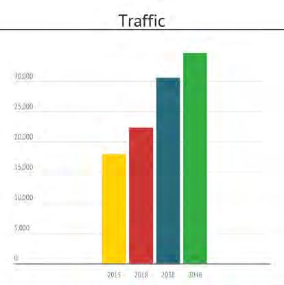
11 Purpose and Need: Mobility Over 18,000 vehicles travel this portion of IH 20 each day; approximately 9,000 (50%) are trucks Accident Delay 30 minutes to 8 hours Traffic backed up to Eastland (west) and Weatherford (east) Back-ups worse on holidays Lack of emergency staff/resources to manage traffic for major incidents 11


12 Purpose and Need: Access Lack of frontage roads When incident occurs traffic diverted to limited number of roadways in the area Access to IH 20 incidents by emergency responders First responders park as close as possible Then walk/wheel equipment to crash site In some instances crash site may be a long distance from roadway access points 12
13 PRELIMINARY DESIGN August 25, 2015
 Optimize ROW")

14 Design Goals and Objectives Enhance Safety Reduce roadway grade Straighten curves Reduce roadway superelevation (banking) Optimize ROW Addition of frontage roads for better incident management Improve freight movement Accommodate future expansion Minimize constructability challenges 14
15 Alternatives Considered 1 Option 3 Options 5 Options 15

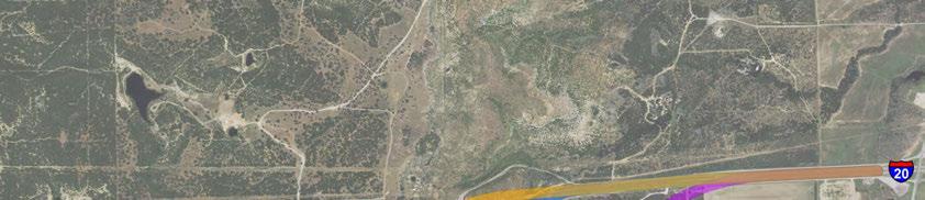
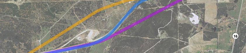
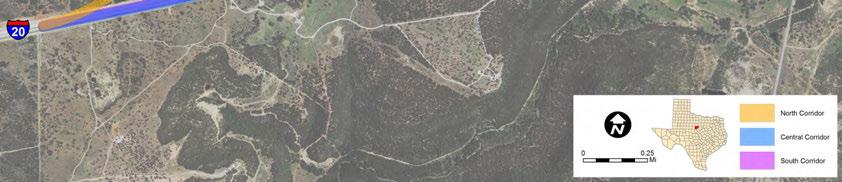
16 North Corridor North Corridor Constraints Substantial ROW needed to the north of the existing highway and safety rest area Requires significant utility relocation Substantial earth work and heavy rock excavation New interchange to access the safety rest area from the interstate 16
17 Central Corridor Central Corridor Constraints ROW impacts due to frontage roads north of the safety rest area Does not provide the optimal safety improvements to grade, curve and superelevation (banking) Difficulty in maintaining existing four lanes of traffic during construction Constructability challenges 17
18 South Corridor South Corridor Constraints Substantial ROW impacts to the south and to the north due to frontage road extending around safety rest area Significant earth work to the north and south of existing alignment 18


19 Proposed IH 20 at Ranger Hill ROW Limits Adds continuous frontage roads for better access for incident management Provides additional climbing lane to improve freight movement Accommodates future expansion ROW Limits Optimizes ROW Proposed frontage road and main lane configuration for current alternatives Consistent with identified design goals and objectives 19
 Pros Flatter horizontal")

20 Proposed Alternative 1 1 Degree Proposed Existing Alternative Details Passing lanes for westbound traffic Continuous frontage roads Access to rest area/braided ramps Median barrier (54-inch) Pros Flatter horizontal curve Flatter superelevation (banking) Keeps existing travel lanes open during construction Drainage and stormwater runoff Minimize constructability challenges Cons Preliminary estimate of approximately 100 acres of ROW 20

 Pros Preliminary estimate of")
 Sharper horizontal")
21 Proposed Alternative Degree Proposed Existing Alternative Details Passing lanes for westbound traffic Continuous frontage roads Access to rest area/braided ramps Median barrier (54-inch) Pros Preliminary estimate of approximately 80 acres of ROW Keeps existing travel lanes open during construction Cons Steeper superelevation (banking) Sharper horizontal curve Drainage and stormwater runoff Greater constructability challenges 21

 and flatter horizontal curves")
22 Superelevation (Banking) Superelevation (banking) is a function of the horizontal curve design Roadway banking/pavement rotation Balances vehicles along with friction Steeper superelevation (banking) Ideal for dry pavement conditions Potentially hazardous during rain and winter events Minimal roadway superelevation (banking) and flatter horizontal curves improve safety 22
")
23 Superelevation (Banking) Comparison 23
24 Summary: Alternatives 1 and 2 Alternative 1 Alternative 2 No. of Parcels 5 5 Design Speed 75 MPH 75 MPH Profile Grade 3.5% 3.5% Constructability Challenges Large amounts of cut/fill Access to existing driveways Large amounts of cut/fill Access to existing driveways Construction Staging/steeper slopes Pros Cons Flatter horizontal curve (1 degree) Keeps existing travellanes open during construction Flatter superelevation(3.7%) Better drainage and runoff Flatter construction slopes Preliminaryestimate is approximately 100 acres of ROW Preliminaryestimate is approximately 80 acres of ROW Keeps travel lanes open during construction Steeper superelevation (5.1%) Sharper horizontal curve (1.5 degrees) Drainage and runoff Steeper construction slopes 24


25 Next Steps Select Alternative for further evaluation Value Engineering Study September 2015 Public Involvement Ongoing meetings with Affected Property Owners First Public Meeting August 25, 2015 Second Public Meeting Fall 2015 Public Hearing Spring 2016 Draft EA Spring 2016 Final EA/FONSI Summer
26 THANK YOU Comment period ends September 4, 2015 August 25, 2015
I-20 ODESSA-MIDLAND CORRIDOR STUDY. Public Meeting for Schematic Design
 I-20 ODESSA-MIDLAND CORRIDOR STUDY Public Meeting for Schematic Design The environmental review, consultation, and other actions required by applicable Federal environmental laws for this project are being,
Roadway Design Manual
 Roadway Design Manual Manual Notice Archive by Texas Department of Transportation (512) 302-2453 all rights reserved Manual Notice 2009-1 From: Manual: Mark A. Marek, P.E Roadway Design Manual Effective
Design Criteria. Design Criteria
 F Design Criteria Design Criteria Ministry of Transportation Ministère des Transports DESIGN CRITERIA Page: 1 of 13 WORK PROJECT NO. N/A GO Bloomington Station TYPE OF PROJECT LOCATION Bloomington Road
DESIGN MEMORANDUM WITH DESIGN EXCEPTIONS SP SP
 DRAFT NOT FINAL (Note: document was not finalized due to an eastbound stopping site distance design issue that requires more detailed bridge and roadway design considerations. This discussion starts on
Preliminary Engineering Study
 Preliminary Engineering Study Open House # 2 June 6, 2018 PREPARED FOR: PREPARED BY: Agenda Background and status of preliminary engineering study County Road 26 design summary County Road 63 design summary
SECTION 1A NEW JERSEY TURNPIKE GEOMETRIC DESIGN
 SECTION 1A NEW JERSEY TURNPIKE GEOMETRIC DESIGN Table of Contents Page No 1A.1 GENERAL...1 1A.1.1 DESIGN CONTROLS...1 1A.2 MAINLINE ROADWAYS...4 1A.2.1 ROADWAY DESIGNATION...4 1A.2.2 DESIGN SPEED...4 1A.2.3
List of Display Boards
 List of Display Boards Welcome Introduction Municipal Class Environmental Assessment (EA) Process Need and Justification for an Interchange Alternatives for Evaluation Vertical and Horizontal Alignments
Pine Hills Road Pedestrian/Bicycle Safety Study Board of County Commissioners Work Session
 Pine Hills Road Pedestrian/Bicycle Safety Study Board of County Commissioners Work Session February 20, 2018 Meeting Agenda Study Overview Existing Conditions Access Management Potential Gateway Features
East Downtown Tax Increment Reinvestment Zone (TIRZ) No. 15 Infrastructure Assessment Study
 No. 15 Infrastructure Assessment Study") East Downtown Tax Increment Reinvestment Zone (TIRZ) No. 15 Infrastructure Assessment Study Houston, TX Technical Memorandum April 15 th, 2009 Prepare by: 2950 North Loop West, Ste. 900 Houston, TX 77092
East Downtown Tax Increment Reinvestment Zone (TIRZ) No. 15 Infrastructure Assessment Study Houston, TX Technical Memorandum April 15 th, 2009 Prepare by: 2950 North Loop West, Ste. 900 Houston, TX 77092
ENGINEER S PRELIMINARY REPORT. for the #######-###### COLLISION
 ENGINEER S PRELIMINARY REPORT for the #######-###### COLLISION By: Lance E. Robson, P.E. October 3, 2005 1 INVESTIGATION OF THE #######-###### COLLISION ENGINEER S PRELIMINARY REPORT October 3, 2005 ---------------------------------------------------------------------------------------------------------------
Paul Huston, P.E., Design-Build Coordinator Chuck Gonderinger, HDR Engineering. Minnesota Department of Transportation (the Department)
") To: From: Paul Huston, P.E., Design-Build Coordinator Chuck Gonderinger, HDR Engineering Date: March 20, 2001 Subject: Roadway Geometric Design Criteria Project: TH 14/218 Design-Build Project, SP 7408-29,
To: From: Paul Huston, P.E., Design-Build Coordinator Chuck Gonderinger, HDR Engineering Date: March 20, 2001 Subject: Roadway Geometric Design Criteria Project: TH 14/218 Design-Build Project, SP 7408-29,
Roadway Design Manual
 Roadway Design Manual Revised December 2013 2013 by Texas Department of Transportation (512) 302-2453 all rights reserved Manual Notice 2013-1 From: Manual: Mark A. Marek, P.E Roadway Design Manual Effective
State Road 54/56 Tampa Bay s Northern Loop. The Managed Lane Solution Linking I-75 to the Suncoast Parkway
 State Road 54/56 Tampa Bay s Northern Loop The Managed Lane Solution Linking I-75 to the Suncoast Parkway SUNCOAST PARKWAY Both I 75 and the Suncoast Parkway are planning, or in the process of constructing,
Alberta Infrastructure HIGHWAY GEOMETRIC DESIGN GUIDE AUGUST 1999
 Alberta Infrastructure HIGHWAY GEOMETRIC DESIGN GUIDE AUGUST 1999,1'(; A ACCELERATION Data on acceleration from stop D-29 Effects of grade D-35 Intersections D-97, D-99 Lanes D-97, F-5, F-7, F-15, F-21,
Figure 1: Graphical definitions of superelevation in terms for a two lane roadway.
 Iowa Department of Transportation Office of Design Superelevation 2A-2 Design Manual Chapter 2 Alignments Originally Issued: 12-31-97 Revised: 12-10-10 Superelevation is the banking of the roadway along
Frequently Asked Questions
 Frequently Asked Questions Business US 190 in Copperas Cove From Avenue D to Constitution Drive What is access management? A. Access Management is a growing effort by government agencies to improve how
BETHEL ROAD AND SEDGWICK ROAD CORRIDOR STUDY
 DRAFT PLAN City Council Meeting August 14, 2017 STUDY AREA Sedgwick Corridor State Route 160, principal arterial with Class 3 access management designation, commuter and freight route, connection to SR
3-13 UFC - GENERAL PROVISIONS AND GEOMETRIC DESIGN FOR ROADS, STREETS, WALKS, AND OPEN
 maintenance, and erosion. Stability is required to maintain the integrity of the pavement structure, and a slope stability analysis should be conducted for cuts and fills greater than 15 feet. For lower
GDOT Elements of Design. Course ID: GDOT PDH Credits
 GDOT Elements of Design Course ID: GDOT-06 3 PDH Credits Civil Engineer Educators LLC 1026 Timberwolf Lane Juneau, AK 99801 Email: support@civilpdh.com Chapter 4 Contents 4. ELEMENTS OF DESIGN 1 4.1. Sight
INDEX. Geometric Design Guide for Canadian Roads INDEX
 Acceleration lane, see Lanes, Acceleration Access, 8.1 Access Management and Functional Classification 8.2 Access Management by Design Classification 8.3 Access Configuration 8.4 Building Set-Back Guidelines
Colerain Avenue Roadway Improvements. Sponsored by Hamilton County Engineer
 Colerain Avenue Roadway Improvements Sponsored by Hamilton County Engineer Participants Lead Agency: Hamilton County Engineer Review and Approval: Ohio Department of Transportation Design Engineer: Edwards
Introduction...pg. 1. Study Area...pg. 1. Study Purpose and Need...pg. 2. Study Coordination and Development... pg. 3. Public Involvement...pg.
 Table of Contents Introduction...pg. 1 Study Area...pg. 1 Study Purpose and Need...pg. 2 Study Coordination and Development... pg. 3 Public Involvement...pg. 4 Evaluation of Alternatives...pg. 4 Preferred
CASTLE CREEK CORRIDOR PLANNING PUBLIC OPEN HOUSE
 CASTLE CREEK CORRIDOR PLANNING PUBLIC OPEN HOUSE Wednesday, November 15, 2017 AGENDA Project Background and Today s Goals Corridor Constraints and Conflicts Usage Information Public Process Schedule Review
WYDOT DESIGN GUIDES. Guide for. Non-NHS State Highways
 WYDOT DESIGN GUIDES Guide for Non-NHS State Highways 2014 GUIDE FOR Non-NATIONAL HIGHWAY SYSTEM (Non-NHS) STATE HIGHWAYS PRESERVATION REHABILITATION RECONSTRUCTION INTRODUCTION This Guide is directed to
Welcome. Thank you for your interest in the Lewis & Clark Viaduct Concept Study
 Welcome Thank you for your interest in the Lewis & Clark Viaduct Concept Study Please use the arrows in the upper left hand corner to navigate through the presentation. Use the envelope icon to ask a question
Friday, May 20, :46 PM Cambria N Armstrong Fw: Wolf Creek REV.pdf
 David Johnson From: Sent: To: Cc: Subject: Attachments: Thomas Malecek Friday, May 20, 2011 12:46 PM david@westerneco.com Cambria N Armstrong Fw: Wolf Creek 05-16-11 REV.pdf David,
Acknowledgements. Mr. David Nicol 3/23/2012. Daniel Camacho, P.E. Highway Engineer Federal Highway Administration Puerto Rico Division
 Daniel Camacho, P.E. Highway Engineer Federal Highway Administration Puerto Rico Division Acknowledgements Mr. David Nicol Director, FHWA Office of Safety FHWA Office of Safety http://safety.fhwa.dot.gov/provencountermeasures/
Intersection Traffic Control Feasibility Study
 Intersection Traffic Control Feasibility Study CSAH 9 at CSAH 60 (185th Avenue) Prepared For: Dakota County Transportation Department Western Service Center 14955 Galaxie Avenue, 3rd Floor Apple Valley,
Water Street Promenade Engineering and Design Services
 Preliminary Design Presentation Parking & Traffic Safety Committee Water Street Promenade Engineering and Design Services July 16,2014 November 3, 2016 Education / Infrastructure / Innovation 1 Project
FM 471. Open House Public Meeting FM 471
 Open House Public Meeting November 12, 2014 FROM: LP 1604 TO: FM 3487 BEXAR COUNTY OPEN HOUSE PUBLIC MEETING November 12, 2014 H.B. Zachry Middle School 9410 Timber Pass 5:00 7:00 PM San Antonio, TX 78250
Roadway Safety Design
 Roadway Safety Design An Engineer s Guide to Evaluating the Safety of Design Alternatives Course Notes Product 5-4703-01-P3 SAFETY BY DESIGN Multilane Highways and Freeways Workshop July 2009 Published:
Corridor Studies. LA 415 and LA 73
 Corridor Studies LA 415 and LA 73 Project Approach for Both Corridors 1. Data Collection 2. Data Summary 3. Traffic Analysis 4. Micro-Simulation modeling 5. Generation of alternatives 6. Modeling alternatives
NORTH HOUSTON HIGHWAY IMPROVEMENT PROJECT DRAFT NEED AND PURPOSE
 NORTH HOUSTON HIGHWAY IMPROVEMENT PROJECT DRAFT NEED AND PURPOSE APPROVED BY FHWA: JULY 2010 UPDATED: OCTOBER 2011 Section 1 Need for and Purpose of Proposed Action Per Council on Environmental Quality
AGENDA REPORT. Issue: Discussion of potential improvements on Barnwell Road at Niblick Drive
 AGENDA REPORT To: From: By: Honorable Mayor and City Council Members Warren Hutmacher, City Manager Tom Black, Public Works Director Date: March 23, 2016 Agenda: March 28, 2016 WORK SESSION AGENDA: Barnwell
Please find below the Town staff s responses to NCDOT s recommended roadway stipulations listed in a letter dated May 25, 2015.
 TOWN OF CHAPEL HILL Public Works Department 6850 Millhouse Road Chapel Hill, NC 27516-8173 phone (919) 969-5100 fax (919) 969-2003 www.townofchapelhill.org TO: FROM: Chuck Edwards, NCDOT Division 7 District
Access Management Standards
 Access Management Standards Section 1: Application of Access Standards This chapter describes the Department's access management standards for access connections on the county roadway system. The standards
Route 47 (North Main Street) Reconstruction
 Reconstruction") TOWN OF SUNDERLAND Route 47 (North Main Street) Reconstruction Presented by Lou Rabito, P.E. Presented to Town of Sunderland June 11, 2018 Project Overview MassDOT Project No. 607245 Resurfacing and Related
TOWN OF SUNDERLAND Route 47 (North Main Street) Reconstruction Presented by Lou Rabito, P.E. Presented to Town of Sunderland June 11, 2018 Project Overview MassDOT Project No. 607245 Resurfacing and Related
Traffic Control Inspection Checklist Segment:
 Traffic Control Inspection Checklist Segment: Simon Contractors Simon Contractors Originator: Description Reviewed by: Initials Date Distribution: Traffic Quality Manager, Site Assistant Traffic Manager
7th Street Bridge Project. Public Presentation February 24, :30pm-8pm
 7th Street Bridge Project Public Presentation February 24, 2014 6:30pm-8pm Public Meeting Agenda Welcome and introductions Judith Buethe Opening remarks - David Leamon, PE/Hans Strandgaard, PE Project
Item to be Addressed Checklist Consideration YES NO N/A Required Description Complete Streets Guidelines
 Passaic County Complete Streets Checklist - Concept Development Project Name Item to be Addressed Checklist Consideration YES NO N/A Required Description Complete Streets Guidelines Existing Plans Have
Parks Highway: MP Lucus Road to Big Lake Road
 2 Purpose and Need 2.1 Corridor History The Parks Highway is a 324-mile long Rural Interstate Highway that extends from its intersection with the Glenn Highway north to Fairbanks, Alaska. The Parks Highway
# Southeastern Wisconsin Regional Freeway System Reconstruction Study and Preliminary Recommended Plan
 #70421 Southeastern Wisconsin Regional Freeway System Reconstruction Study and Preliminary Recommended Plan Public Information Meetings and Hearings May June 2002 1 Reason for Freeway System Study 270-mile
Municipal Class EA To Address Traffic Congestion On The Ontario Street Corridor (Grand Bend) Public Information Meeting June 4, 2018
 Public Information Meeting June 4, 2018") Municipal Class EA To Address Traffic Congestion On The Ontario Street Corridor (Grand Bend) Public Information Meeting June 4, 2018 Background Agenda Traffic Study Update Class EA Alternatives Bridge
Municipal Class EA To Address Traffic Congestion On The Ontario Street Corridor (Grand Bend) Public Information Meeting June 4, 2018 Background Agenda Traffic Study Update Class EA Alternatives Bridge
Geometric Design Tables
 Design Manual Chapter 5 - Roadway Design 5C - Geometric Design Criteria 5C-1 Geometric Design Tables A. General The following sections present two sets of design criteria tables - Preferred Roadway Elements
Geometric designs for Safe Highways. Dr. Manoj M. Asst. Professor Department of Civil Engineering IIT Delhi
 Geometric designs for Safe Highways Dr. Manoj M. Asst. Professor Department of Civil Engineering IIT Delhi WORKSHOP-CUM-TRAINING PROGRAMME ON ROAD SAFETY 17th 21st September 2018 Outline Introduction Cross
Section 4 Basic Geometric Design Elements
 4.1 General Section 4 Basic Geometric Design Elements BDC07MR-01 Geometric highway design pertains to the visible features of the highway. It may be considered as the tailoring of the highway to the terrain,
700 Multi-Modal Considerations
 700 Multi-Modal Considerations Table of Contents 701 Railroads... 7-1 701.1 Background... 7-1 701.2 Crossing At-Grade... 7-1 701.2.1 General... 7-1 701.2.2 Railroad Parallel to Highway... 7-1 701.3 Lateral
Access Management Benefits & Techniques. Access Management Workshop June 2, 2006
 Access Management Benefits & Techniques Access Management Workshop June 2, 2006 1 Benefits of Access Management Safety As access density increases, crash rates increase Increasing the density of access
PERFORMANCE ACTIVITY 405 LIMB MANAGEMENT
 PERFORMANCE ACTIVITY 405 LIMB MANAGEMENT 405 LIMB MANAGEMENT ACTIVITY DESCRIPTION Cut and/or remove and/or grind tree limbs from the right-of-way. TRAFFIC CONTROL Utilize intermittent mobile operations
Part-time Shoulder Use Guide
 1 Part-time Shoulder Use Guide FHWA Guide AASHTO SCOD, Baltimore, MD June 2016 DOTs Face Increasing Challenges 2 Performance Based Practical Design 3 PBPD is a decision making approach that helps agencies
DETECTABLE WARNING SURFACES SHALL BE PROVIDED AT THE FOLLOWING LOCATIONS ON PEDESTRIAN ACCESS ROUTES:
 GENERAL NOTES: CURB NOTES: 5'-0" MIN 5'-0" 5'-0" MIN 1. 2. THESE SHEETS ARE IN ACCORDANCE WITH THE AMERICANS WITH DISABILITIES ACT (ADA), AND THE REQUIREMENTS OF THE 2011 PROPOSED ACCESSIBILITY GUIDELINES
CHAPTER 16 PEDESTRIAN FACILITIES DESIGN AND TECHNICAL CRITERIA TABLE OF CONTENTS
 CHAPTER 16 PEDESTRIAN FACILITIES DESIGN AND TECHNICAL CRITERIA TABLE OF CONTENTS Section Title Page 16.1 General... 16-1 16.1.1 AASHTO Reference... 16-1 16.1.2 ADA Requirements... 16-1 16.2 Sidewalks...
Route 29 Corridor Assessment Update. Development of Possible Solutions
 Route 29 Corridor Assessment Update Development of Possible Solutions Public Workshop #3 October 27, 2016 Purpose of Developing Possible Solutions Recap of where we ve been and timeline for moving forward
Approximately 360 trail users cross during a typical summer weekday and 420 cross during a typical summer
 5. PARKR ROAD AT MISSISSIPPI AVN CROSSIN xisting Conditions The High ine Canal trail crosses Parker Road near the Mississippi Avenue intersection (crossing location #3 on Figure 1). South of Parker, the
NEW BRAUNFELS SEGUIN AREA REGIONAL TRANSPORTATION DRAFT PLAN NEW BRAUNFELS CITY COUNCIL MEETING
 NEW BRAUNFELS SEGUIN AREA REGIONAL TRANSPORTATION DRAFT PLAN NEW BRAUNFELS CITY COUNCIL MEETING February 13, 2012 This regional transportation plan will: 1. Review existing plans for the cities and counties,
Description: Widen I-64 to 6 lanes from I-265 to the KY 53 interchange in Shelby County.
 I-64 KIPDA ID # 350 Project Type: ROADWAY CAPACITY Description: Widen I-64 to 6 lanes from I-265 to the KY 53 interchange in Shelby County. Purpose: Project will improve capacity and address safety concerns.
WYDOT DESIGN GUIDES. Guide for. NHS Arterial (Non-Interstate)
") WYDOT DESIGN GUIDES Guide for NHS Arterial (Non-Interstate) 2014 GUIDE FOR NATIONAL HIGHWAY SYSTEM (NHS) HIGHWAYS (NHS ARTERIALS, Non-Interstate) PRESERVATION REHABILITATION RECONSTRUCTION INTRODUCTION
WYDOT DESIGN GUIDES Guide for NHS Arterial (Non-Interstate) 2014 GUIDE FOR NATIONAL HIGHWAY SYSTEM (NHS) HIGHWAYS (NHS ARTERIALS, Non-Interstate) PRESERVATION REHABILITATION RECONSTRUCTION INTRODUCTION
Meeting Notes. PIM Meeting #1 CTH D Reconstruction Nenno Road to Canadian National Railroad Town of Wayne Washington County
 Meeting Notes PIM Meeting #1 CTH D Reconstruction Nenno Road to Canadian National Railroad Town of Wayne Washington County Attendees: Date/Time: Location: See attached sign in sheet October 25, 2017; 6:00
SH-6 Corridor Improvement Study Policy Committee Progress Report M O N D AY, J U N E 1 0, B R A Z O S C E N T E R
 SH-6 Corridor Improvement Study Policy Committee Progress Report M O N D AY, J U N E 1 0, 2 0 1 3 B R A Z O S C E N T E R Project Overview Study Goals and Objectives» Improve traffic flow» Reduce delay»
Public Information Meeting. Warren County Pathway Corridor Project September 27, 2018
 Public Information Meeting Warren County Pathway Corridor Project September 27, 2018 Why are we here? Introduce Study Hear concerns and Ideas Obtain input on preliminary Alternatives Previous Study (2008)
(HIGHWAY GEOMETRIC DESIGN -1)
") LECTURE HOUR-19 TE-1(10CV56) UNIT-3 (HIGHWAY GEOMETRIC DESIGN -1) Width of carriage way: Width of the carriage way or the width of the pavement depends on the width of the traffic lane and number of lanes.
LECTURE HOUR-19 TE-1(10CV56) UNIT-3 (HIGHWAY GEOMETRIC DESIGN -1) Width of carriage way: Width of the carriage way or the width of the pavement depends on the width of the traffic lane and number of lanes.
DISTRICT BICYCLE PROGRAM
 DISTRICT BICYCLE PROGRAM TxDOT Fort Worth District Public Hearing Bicycle Use on the State Highway System Public Hearing Agenda 1 2 3 4 5 6 Introduction Susan Howard TxDOT Public Involvement Specialist
Chapter 4 Traffic Analysis
 Chapter 4 Traffic Analysis PURPOSE The traffic analysis component of the K-68 Corridor Management Plan incorporates information on the existing transportation network, such as traffic volumes and intersection
I-10 AT SCENIC LOOP RD. Open House
 I-10 AT SCENIC LOOP RD Open House General Information I-10 At Scenic Loop Rd KENDALL COUNTY OPEN HOUSE June 30, 2015 Currey Creek Baptist Church 35 Cascade Cavern 5:00 7:00 Boerne, TX 78015 2 Public Meeting
SH 68. Meeting with Affected Property Owners September 9, 2014
 SH 68 Meeting with Affected Property Owners September 9, 2014 SH 68 US 83/I-2 TO US 281/I-69C Meeting with Affected Property Owners (MAPO) September 9, 2014 Agenda Open Meeting with Affected Property Owners
AASHTO Use Only Establishment of a U.S. (Interstate) Route IH 69 Action taken by SCOH: Extension of a U.S. (Interstate)Route
 Route IH 69 Action taken by SCOH: Extension of a U.S. (Interstate)Route") American Association of State Highway and Transportation Officials An Application from the State Highway or Transportation Department of Texas for: Elimination of a U.S. (Interstate) Route AASHTO Use Only
American Association of State Highway and Transportation Officials An Application from the State Highway or Transportation Department of Texas for: Elimination of a U.S. (Interstate) Route AASHTO Use Only
Recommended Roadway Plan Section 2 - Land Development and Roadway Access
 Recommended Roadway Plan Section 2 - Land Development and Roadway Access SECTION 2 Land Development and Roadway Access 2.1 Land Use and Access Management The Federal Highway Administration (FHWA) defines
J-Turn An Intersection Safety Improvement Purdue Road School 2016 Tuesday, March 8, 2016 Brian Malone, INDOT & Josh Cook, HNTB
 J-Turn An Intersection Safety Improvement Purdue Road School 2016 Tuesday, March 8, 2016 Brian Malone, INDOT & Josh Cook, HNTB US 231 and SR 62 and SR 68 US 231 and SR 62 Intersection Traffic Data Traffic
October 2004 REVISIONS (2) SUPERELEVATION DEVELOPMENT 11.3(2)
 SUPERELEVATION DEVELOPMENT 11.3(2)") October 2004 REVISIONS (2) Chapter 11 HORIZONTAL ALIGNMENT SUPERELEVATION DEVELOPMENT 11.3(2) Chapter 12 VERTICAL ALIGNMENT VERTICAL CURVES PASSING SIGHT DISTANCE 12.5(2) VERTICAL CURVES STOPPING SIGHT
October 2004 REVISIONS (2) Chapter 11 HORIZONTAL ALIGNMENT SUPERELEVATION DEVELOPMENT 11.3(2) Chapter 12 VERTICAL ALIGNMENT VERTICAL CURVES PASSING SIGHT DISTANCE 12.5(2) VERTICAL CURVES STOPPING SIGHT
Managed Lanes. Steve Schilke, P.E. Major Projects Unit Head District 1. Illinois Traffic Engineering and Safety Conference October 2016
 Managed Lanes Steve Schilke, P.E. Major Projects Unit Head District 1 Illinois Traffic Engineering and Safety Conference October 2016 Agenda Managed Lanes Projects I-55 (Stevenson Expressway) Express Toll
How Might Connected Vehicles and Autonomous Vehicles Influence Geometric Design? October 10, 2017
 How Might Connected Vehicles and Autonomous Vehicles Influence Geometric Design? October 10, 2017 Overview Design Vehicle Design Driver Potential Geometric Impacts of Autonomous Vehicles Connected Vehicles
Off-Road Facilities Part 1: Shared Use Path Design
 Off-Road Facilities Part 1: Shared Use Path Design Presentation by: Eric Mongelli, P.E. Tom Huber October 9, 2012 FOLLOW THE CONVERSATION ON TWITTER Toole Design Group is live tweeting this webinar @tooledesign
Update to DOTD Roundabout Design Policy
 Update to DOTD Roundabout Design Policy Roundabout In Louisiana Louisiana has 18 roundabouts in operation and 53 proposed History EDSM s or Engineering Directives and Standards set DOTD policies, procedures,
Transportation Corridor Studies: Summary of Recommendations
 Transportation Corridor Studies: Summary of Recommendations Route 4 Corridor Study: Route 10 Corridor Study: Route 44 Corridor Study: Route 175 Corridor Study: Route 5/15 Corridor Study: Rentschler Field
I-395 Express Lanes Northern Extension Project Crystal City Civic Association September 21, 2016
 I-395 Express Lanes Northern Extension Project Crystal City Civic Association September 21, 2016 Mike Snare, PE, Project Manager Virginia Department of Transportation GEC Michelle Holland, Megaprojects
133 rd Street and 132 nd /Hemlock Street 132 nd Street and Foster Street MINI ROUNDABOUTS. Overland Park, Kansas
 133 rd Street and 132 nd /Hemlock Street 132 nd Street and Foster Street MINI ROUNDABOUTS Overland Park, Kansas September 1, 2017 TABLE OF CONTENTS 1. INTRODUCTION... 1 2. LITERATURE REVIEW... 1 3. CONCEPT
Closing Plenary Session
 TRAFFIC SAFETY CONFERENCE Closing Plenary Session June 9, 2017 Las Colinas, TX Order of Report Out June 9, 2017 Las Colinas, TX Distracted Driving Prioritized Countermeasures Countermeasure 4a Systemically
HIGHWAY 11 CORRIDOR STUDY
 HIGHWAY 11 CORRIDOR STUDY Executive Summary August 2016 Roseau County?æA@?çA@ Warroad Lake of the Woods Roseau Roosevelt Badger?ÄA@ Greenbush Legend N Hwy 11 Study Area Figure 1: Corridor Study Limits
Safety Impacts: Presentation Overview
 Safety Impacts: Presentation Overview The #1 Theme How Access Management Improves Safety Conflict Points The Science of Access Management By Treatment Studies Themes for Texas Access Management Improve
State Street and Pierce Park Lane Intersection Concept Report
 State Street and Pierce Park Lane Intersection Prepared for September 2017 Prepared by CITATION Parametrix. 2017. State Street & Pierce Park Lane Intersection. Prepared by Parametrix, Boise, ID. September
I-395 Express Lanes Northern Extension Project Fairlington Citizens Association September 12, 2016
 I-395 Express Lanes Northern Extension Project Fairlington Citizens Association September 12, 2016 Susan Shaw, PE, Megaprojects Director, Virginia Department of Transportation Amanda Baxter, Special Projects
FOR HISTORICAL REFERENCE ONLY
 To: From: Subject: Electronic Distribution Recipients MINNESOTA DEPARTMENT OF TRANSPORTATION Engineering Services Division Technical Memorandum No. 12-14-B-03 December 18, 2012 Jon M. Chiglo, P.E. Division
Clybourn Ave. Protected Bike Lane Study Halsted St. to Division St.
 Clybourn Ave. Protected Bike Lane Study Halsted St. to Division St. Nathan Roseberry, Senior Engineer Pam Broviak, Project Manager July 24, 2014 Agenda Project Goals Existing Roadway Conditions Traffic
Los Altos Hills Town Council - June 18, 2015 Palo Alto City Council June 22, AGENDA ITEM #2.B Presentation
 Los Altos Hills Town Council - June 18, 2015 Palo Alto City Council June 22, 2015 AGENDA ITEM #2.B Presentation Previous Presentations Los Altos Hills Town Council in May 2014 and February 2015 Palo Alto
Transportation Advisory Board
 C I T Y O F WEATHERFORD Transportation Advisory Board AGENDA REPORT Meeting Date: October 15,2015 Staff Contact: Manny Palacios Jr. Phone: E-mail: 817-598-4296 mpalacios@weatherfordtx.gov SUBJECT: Discuss
Truck Climbing Lane Traffic Justification Report
 ROUTE 7 (HARRY BYRD HIGHWAY) WESTBOUND FROM WEST MARKET STREET TO ROUTE 9 (CHARLES TOWN PIKE) Truck Climbing Lane Traffic Justification Report Project No. 6007-053-133, P 101 Ι UPC No. 58599 Prepared by:
FY STIP. Austin District. November Quarterly Revisions HIGHWAY STATEWIDE TRANSPORTATION IMPROVEMENT PROGRAM
 FY 2011-2014 STIP STATEWIDE TRANSPORTATION IMPROVEMENT PROGRAM HIGHWAY Austin District November Quarterly Revisions November 2011 FY 2011-2014 Transportation Improvement Program Amendments October 10,
PERFORMANCE ACTIVITY 306 DRAINAGE PIPE WORK DESCRIPTION 4
 PERFORMANCE ACTIVITY 306 DRAINAGE PIPE WORK DESCRIPTION 1 WORK DESCRIPTION 2 WORK DESCRIPTION 3 WORK DESCRIPTION 4 Repair Install Remove Clean 306 DRAINAGE PIPE ACTIVITY DESCRIPTION Install, repair, clean,
Driveway Design Criteria
 Design Manual Chapter 5 - Roadway Design 5L - Access Management 5L-4 Driveway Design Criteria A. General For efficient and safe operations, access drives and minor public street intersections can be improved
Owl Canyon Corridor Project Overview and Summary
 Owl Canyon Corridor Project Overview and Summary December 22, 2008 The Owl Canyon corridor (generally the connection between the I-25 / Larimer County Road 70 interchange and the US 287 / Larimer County
RURAL HIGHWAY SHOULDERS THAT ACCOMMODATE BICYCLE AND PEDESTRIAN USE (TxDOT Project ) June 7, Presented by: Karen Dixon, Ph.D., P.E.
 June 7, Presented by: Karen Dixon, Ph.D., P.E.") RURAL HIGHWAY SHOULDERS THAT ACCOMMODATE BICYCLE AND PEDESTRIAN USE (TxDOT Project 0-6840) June 7, 2016 Presented by: Karen Dixon, Ph.D., P.E., TTI Team: Kay Fitzpatrick, Raul Avelar, & Subasish Das Project
RURAL HIGHWAY SHOULDERS THAT ACCOMMODATE BICYCLE AND PEDESTRIAN USE (TxDOT Project 0-6840) June 7, 2016 Presented by: Karen Dixon, Ph.D., P.E., TTI Team: Kay Fitzpatrick, Raul Avelar, & Subasish Das Project
Updated August 1, 2016
 Updated August 1, 2016 American Association of State Highway and Transportation Officials An Application from the State Highway or Transportation Department of North Carolina for: Elimination of a U.S.
WELCOME PTH 59N - PTH 101 INTERCHANGE FUNCTIONAL DESIGN STUDY PUBLIC INFORMATION SESSION MONDAY, JUNE 13, :00 P.M. - 8:00 P.M.
 WELCOME - PTH 1 INTERCHANGE FUNCTIONAL DESIGN STUDY PUBLIC INFORMATION SESSION MONDAY, JUNE 13, 11 4:00 P.M. - 8:00 P.M. PROJECT STUDY AREA 1 Wenzel Street PR 2 Pritchard Farm Farm Road Road McGregor Farm
Proposed Action, Purpose and Need Technical Memorandum
 Proposed Action, Purpose and Need Technical Memorandum MoPac (State Loop 1) Intersections, Austin District From North of Slaughter Lane to South of La Crosse Avenue CSJ: 3136-01-015 Travis County, Texas
NCHRP Superelevation Criteria for Sharp Horizontal Curves on Steep Grades. Research Team: MRIGlobal Pennsylvania State University
 NCHRP 15-39 Superelevation Criteria for Sharp Horizontal Curves on Steep Grades Research Team: MRIGlobal Pennsylvania State University Objective and Scope Develop superelevation criteria for sharp horizontal
BLUETT TRAFFIC CALMING ON-SITE MEETING #2 DISCUSSION SUMMARY
 BLUETT TRAFFIC CALMING ON-SITE MEETING #2 DISCUSSION SUMMARY Date: Wednesday, April 11, 2018 Time: 5:30 p.m. to 7:30 p.m. Location: Clague Middle School parking lot Attendees: Public Present: 42 Council
Iowa Corridor Management Pilot Project Overview. Recommendations For A Corridor Management Program August 2004
 Iowa Corridor Management Pilot Project Overview Recommendations For A Corridor Management Program August 2004 Presentation Overview Project goals Pilot project selection process Analysis results Segment
General References Definitions. (1) Design Guidance. (2) Supporting Information
 Design Guidance. (2) Supporting Information") Chapter 1240 Turning Roadways 1240.01 General 1240.02 References 1240.03 Definitions 1240.04 Turning Roadway Widths 1240.05 Documentation 1240.01 General The roadway on a curve may need to be widened to
Chapter 1240 Turning Roadways 1240.01 General 1240.02 References 1240.03 Definitions 1240.04 Turning Roadway Widths 1240.05 Documentation 1240.01 General The roadway on a curve may need to be widened to
1. What is the Doran Street and Broadway/Brazil Grade Separation Project (Project)?
?") 1. What is the Doran Street and Broadway/Brazil Grade Separation Project (Project)? The Los Angeles County Metropolitan Transportation Authority (Metro) is evaluating the development of a grade separation
1. What is the Doran Street and Broadway/Brazil Grade Separation Project (Project)? The Los Angeles County Metropolitan Transportation Authority (Metro) is evaluating the development of a grade separation
General Design Factors
 Chapter 3: 3-1.0 Introduction General Design Factors Mn/DOT s goals include encouraging and accommodating safe bicycling. From a design perspective, these goals are achieved by first having an understanding