Meeting Notes. PIM Meeting #1 CTH D Reconstruction Nenno Road to Canadian National Railroad Town of Wayne Washington County
|
|
|
- Veronica Lamb
- 5 years ago
- Views:
Transcription
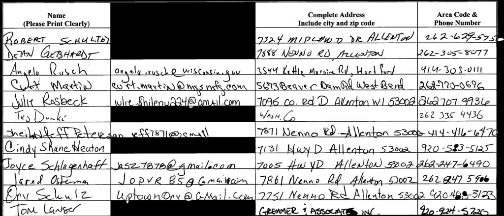
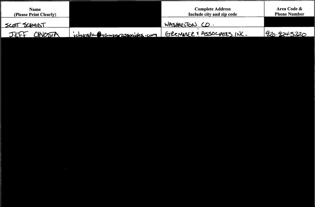
1 Meeting Notes PIM Meeting #1 CTH D Reconstruction Nenno Road to Canadian National Railroad Town of Wayne Washington County Attendees: Date/Time: Location: See attached sign in sheet October 25, 2017; 6:00 pm 7:00 pm Kohlsville Fire Department Summary: The meeting was held with a formal presentation and general question and answer session. An outline of the formal presentation is provided at the end of this meeting summary. Tom Lanser and Jeff Chvosta from Gremmer & Associates, and Scott Schmidt and Ted Dumke from Washington County answered questions during the formal presentation. A few members of the public were present at the meeting and were allowed to ask questions during the general session. Formal Presentation and General Question/Answer Vehicles travel too fast now. With the improvements they will go even faster. o The roadway will be designed for a 60 mph design speed. This is an improvement over the existing conditions and speeding is an enforcement issue. The project will not be as safe for the property owner located at 7131 CTH D (Shane Heaton) since vehicles will be traveling faster. He currently has to walk along CTH D to get to his mailbox located on Nenno Road. o The existing mailbox location is a post office issue. Recommended that the property owner contact the post office to determine if the mailbox can be moved to a location in front of his property before or after the project. o Explained that a turn lane is also being proposed on the eastbound approach to Nenno Road which would allow for additional separation from the through traffic if he would have to continue to walk to his mailbox. Will culvert passing under Nenno Road be upsized? Adjacent property owner stated that the roadway has overtopped in the past which was likely due to the culvert being undersized and partially buried of full of silt. o Designer will verify drainage area and size the culvert accordingly. What will happen to the existing utilities? Will the overhead utilities be buried? o The relocation of the utilities is determined by the individual utility companies. It is likely that the utilities will relocate in a similar fashion to which currently exists along the roadway. The utilities may choose to only relocate facilities in conflict and leave the poles not in conflict located along the existing roadway. 1
2 Schedule o Construction is tentatively scheduled for summer/fall of Other o Jake s Auto would take any waste material from the project. His contact information is as follows: 6585 Midland Court, Allenton, WI (262)

3
4
5 CTH D PIM #1 Presentation Outline 1. Introductions a. Introductions. b. Sign in sheet and copy of the handout (mention comment sheet) 2. Purpose of the meeting a. Update the public on the status of the project b. Share the preliminary design plans for the project and receive their input 3. Summary of proposed project a. Existing roadway typical section. i. Two 11 lanes with a 2 paved shoulder and 3 6 gravel shoulder (typical) b. Proposed roadway improvement and typical section i. Two 12 lanes with 8 shoulders (5 paved) ii. Realignment/reconstruct to improve substandard horizontal and vertical alignment and deteriorated pavement. c. Pavement type i. Asphalt d. Horizontal Alignment Improvements i. Realignment to the north of existing alignment to increase sight distance and meet a 60 mph design speed. ii. Consists of 3 tangent segments and 2 curves. e. Vertical Profile Improvements i. Adjustments to improve sight distance and meet a 60 mph design speed. Cut/fills range up to approximately 10 feet. f. Intersection Improvements i. Upgrade Nenno Road intersection with turn lanes/bypass lanes/tapers ii. Curb and gutter around radii g. Replacement of all cross culverts and driveway culverts. h. Right of way acquisition and temporary limited easements will be necessary throughout the project. A separate real estate acquisition agent will be assisting the County in acquiring the right of way may.
6 4. Schedule a. Right of way acquisition in Spring 2019 b. Utility relocations (not a part of our project) in Fall 2019 c. Construction in Access during construction a. Closed to through traffic (detour) b. Detour will utilize USH 41, STH 33 and STH 175 c. Residential access will be maintained, however there will be select times where they won t have access to their driveways (i.e. culvert installation) d. Access to properties may be limited to one direction. 6. Funding a. This project is funded with 100% Washington County funds. 7. Questions FOR INTERNAL INFORMATION ONLY Traffic CTH D = 1,681 VPD Nenno Road = 152 VPD Wetland Impacts = 26,320 square feet (0.60 acres) Real Estate Fee TLE Vacated Jones 0.19 acres 0.16 acres 0.00 acres Gebhardt 0.03 acres 0.07 acres 0.00 acres Nickel 1.03 acres 0.28 acres 0.00 acres Rosbeck 0.00 acres 0.19 acres 1.24 acres Schlagenhaft 5.43 acres 0.64 acres 1.01 acres State of Wisconsin 1.60 acres 1.19 acres 2.83 acres Totals 8.28 acres 2.53 acres 5.09 acres
CTH M HIGHWAY PROJECT CTH Q to STH 113
 CTH M HIGHWAY PROJECT CTH Q to STH 113 PUBLIC INFORMATIONAL MEETING #3 Wednesday, May 25, 2005 Town of Westport Administration Building 5387 Mary Lake Road 6:00 p.m. to 8:00 p.m. PUBLIC INFORMATIONAL MEETING
This Chapter sets forth the minimum design, technical criteria and specifications to be used in the preparation of all roadway plans.
 4.1 GENERAL This Chapter sets forth the minimum design, technical criteria and specifications to be used in the preparation of all roadway plans. These Roadway Standards are for new construction and modification
SECTION 3 STREET DESIGN
 3.01 GENERAL SECTION 3 STREET DESIGN For purposes of geometric and structural design, streets shall be classified according to the following table. The City Engineer will determine the class of all proposed
Readington Road (C.R. 637) Construction
 Construction") Public Information Meeting Thursday, August 2, 2012 Readington Road (C.R. 637) Construction from Dreahook Road to Harlan School Road Branchburg Township, Somerset County Readington Township, Hunterdon
Public Information Meeting Thursday, August 2, 2012 Readington Road (C.R. 637) Construction from Dreahook Road to Harlan School Road Branchburg Township, Somerset County Readington Township, Hunterdon
INGHAM COUNTY ROAD DEPARTMENT AUSTIN E. CAVANAUGH ADMINISTRATION BUILDING 301 Bush Street, P.O. Box 38, Mason, MI
 INGHAM COUNTY ROAD DEPARTMENT AUSTIN E. CAVANAUGH ADMINISTRATION BUILDING 301 Bush Street, P.O. Box 38, Mason, MI 48854-0038 March 27, 2018 William M. Conklin, P.E. Managing Director FOR IMMEDIATE RELEASE:
Driveway Design Criteria
 Design Manual Chapter 5 - Roadway Design 5L - Access Management 5L-4 Driveway Design Criteria A. General For efficient and safe operations, access drives and minor public street intersections can be improved
IH 20 RANGER HILL PUBLIC MEETING
 IH 20 RANGER HILL PUBLIC MEETING AUGUST 25, 2015 IH 20, Eastland County, TX CSJ 0007-06-084 IH 20 from 3.5 mi. East of LP 254 to SH 16 (Ranger Hill) August 25, 2015 Agenda Introductions Purpose of the
Information on display. Inside this handout. Triangle Area revisions. Project need displays. Preferred alternative on aerial maps
 Public information meeting #4 4 to 7 p.m., September 30, 2009 Hales Corners Welcome Thank you for attending this public information meeting for the WIS 100 Corridor Study. Your interest and comments are
11 CHECKLISTS Master Checklists All Stages CHECKLIST 1 FEASIBILITY STAGE AUDIT
 11 CHECKLISTS 11.1 Master Checklists All Stages CHECKLIST 1 FEASIBILITY STAGE AUDIT 1.1 General topics 1. Scope of project; function; traffic mix 2. Type and degree of access to property and developments
Project Update May 2018
 Project Update May 2018 Dakota County, in cooperation with the City of Lakeville, is planning to reconstruct 202 nd Street West (County Road 50) from Holyoke Avenue to Cedar Avenue (County Road 23). 202
City of Madison, East Johnson Street North Baldwin Street to First Street Local Street Dane County
 City of Madison, East Johnson Street North Baldwin Street to First Street Local Street Dane County Public Involvement Meeting Thursday, April 28, 2016 6 to 8 P.M. Lapham Elementary School 1045 E. Dayton
City of Madison, East Johnson Street North Baldwin Street to First Street Local Street Dane County
 City of Madison, East Johnson Street North Baldwin Street to First Street Local Street Dane County Public Involvement Meeting Thursday, November 10, 2016 5:30 to 7 P.M. Festival Foods 810 E. Washington
AGENDA REPORT. Issue: Discussion of potential improvements on Barnwell Road at Niblick Drive
 AGENDA REPORT To: From: By: Honorable Mayor and City Council Members Warren Hutmacher, City Manager Tom Black, Public Works Director Date: March 23, 2016 Agenda: March 28, 2016 WORK SESSION AGENDA: Barnwell
Access requests to County streets and roadways are processed through one of the following methods:
 13.1 GENERAL APPLICATION PROCESS Access requests to County streets and roadways are processed through one of the following methods: A. Planned Developments may set general locations for access points.
GWINNETT COUNTY DEPARTMENT OF TRANSPORTATION
 GWINNETT COUNTY DEPARTMENT OF TRANSPORTATION 1 of 7 June 20, 2007 GENERAL: The following guidelines shall be used in the determination of the requirement for left turn lanes for development projects and
Swamp Road Residents Study
 Swamp Road Residents Study SRRG Meeting with PennDot and Elected Officials Newtown and Wrightstown, PA April 25, 2008 Newtown Township Section of Swamp Road Limited Public Funds No reconstruction of a
Design Criteria. Design Criteria
 F Design Criteria Design Criteria Ministry of Transportation Ministère des Transports DESIGN CRITERIA Page: 1 of 13 WORK PROJECT NO. N/A GO Bloomington Station TYPE OF PROJECT LOCATION Bloomington Road
Complete Streets. Designing Streets for Everyone. Sarnia
 Complete Streets Designing Streets for Everyone Sarnia Complete Streets ~ Sarnia ~ 2018 Introduction Our City is made up of a network of streets that we use to go for a walk, cycle to work, drive to the
CHAPTER 16 PEDESTRIAN FACILITIES DESIGN AND TECHNICAL CRITERIA TABLE OF CONTENTS
 CHAPTER 16 PEDESTRIAN FACILITIES DESIGN AND TECHNICAL CRITERIA TABLE OF CONTENTS Section Title Page 16.1 General... 16-1 16.1.1 AASHTO Reference... 16-1 16.1.2 ADA Requirements... 16-1 16.2 Sidewalks...
Introduction to Roadway Design
 Chapter Introduction to Roadway Design 1 This chapter lays the foundation for the Roadway Design course. You examine the roadway design workflow and the completed drawing files and review the project scope,
Poor pavement condition Substandard Intersections. / Substandard bike/pedestrian/transit accommodations. Driveway access Environmental concerns
 Public Informational Meeting University Avenue (Allen Boulevard Segoe Road) March 23, 2011 City of Madison City of Middleton Village of Shorewood Hills Dane County Existing Roadway Conditions Poor pavement
Alberta Infrastructure HIGHWAY GEOMETRIC DESIGN GUIDE AUGUST 1999
 Alberta Infrastructure HIGHWAY GEOMETRIC DESIGN GUIDE AUGUST 1999,1'(; A ACCELERATION Data on acceleration from stop D-29 Effects of grade D-35 Intersections D-97, D-99 Lanes D-97, F-5, F-7, F-15, F-21,
Bluffdale/ UDOT South High-T Intersection Project Type Operations
 Bluffdale/ UDOT 14600 South High-T Intersection Project Type Operations 14600 South and Redwood Road $ 600,000 $ 550,000 This project is to install a new High-T intersection at Redwood Road and 14600 South
Pine Hills Road Pedestrian/Bicycle Safety Study Board of County Commissioners Work Session
 Pine Hills Road Pedestrian/Bicycle Safety Study Board of County Commissioners Work Session February 20, 2018 Meeting Agenda Study Overview Existing Conditions Access Management Potential Gateway Features
West Dimond Blvd Upgrade Jodhpur Street to Sand Lake Road
 West Dimond Blvd Jodhpur St to Sand Lake CSS Transportation Project Summary Municipality of Anchorage Project # 05 005 Project Manager: John Smith, P.E. (MOA PM&E) Project Administrator: Julie Makela,
PERFORMANCE ACTIVITY 306 DRAINAGE PIPE WORK DESCRIPTION 4
 PERFORMANCE ACTIVITY 306 DRAINAGE PIPE WORK DESCRIPTION 1 WORK DESCRIPTION 2 WORK DESCRIPTION 3 WORK DESCRIPTION 4 Repair Install Remove Clean 306 DRAINAGE PIPE ACTIVITY DESCRIPTION Install, repair, clean,
Water Street Promenade Engineering and Design Services
 Preliminary Design Presentation Parking & Traffic Safety Committee Water Street Promenade Engineering and Design Services July 16,2014 November 3, 2016 Education / Infrastructure / Innovation 1 Project
CITY OF WOODINVILLE ONGOING CAPITAL IMPROVEMENT PROJECT UPDATES
 CITY OF WOODINVILLE ONGOING CAPITAL IMPROVEMENT PROJECT UPDATES PROJECT LOCATION MAP (1) DEYOUNG PARK IMPROVEMENTS Project Description - DeYoung Park Improvements include treehouse deck, play area, new
Cincinnati Dayton Rd Widening
 Cincinnati Dayton Rd Widening Project Overview Widening of Cincinnati Dayton Rd to four lanes - providing a center turn lane and an additional northbound lane Realignment of Station Rd Widening of bridge
SUNRAY DRIVE/PERRINE RANCH ROAD FROM WEST OF DARLINGTON ROAD TO GRAND BOULEVARD AND PERRINE RANCH ROAD AT SEVEN SPRINGS BOULEVARD
 SUNRAY DRIVE/PERRINE RANCH ROAD FROM WEST OF DARLINGTON ROAD TO GRAND BOULEVARD AND PERRINE RANCH ROAD AT SEVEN SPRINGS BOULEVARD FINAL ROUTE AND POND STUDY PROJECT NO. C-9570.10 Prepared for: Pasco County
ROAD OCCUPANCY PERMIT APPLICATION # Damascus Township, 60 Conklin Hill Road, Damascus, PA Tel Fax
 Instructions: For a driveway access permit, fill in sections 1, 2, 3 and 4, and the appropriate drawings and sign. For a Utility access, fill in sections 1, 2, 3 and 5, and figures 1 and 3. Prepare a detailed
DESIGN MEMORANDUM WITH DESIGN EXCEPTIONS SP SP
 DRAFT NOT FINAL (Note: document was not finalized due to an eastbound stopping site distance design issue that requires more detailed bridge and roadway design considerations. This discussion starts on
SOUTHWEST SHEPHERDSVILLE SMALL AREA TRANSPORTATION STUDY
 SOUTHWEST SHEPHERDSVILLE SMALL AREA TRANSPORTATION STUDY Final Report October 2008 Prepared for: City of Shepherdsville, Kentucky Prepared by: ACKNOWLEDGEMENTS Project Steering Committee Members Sherman
122 Avenue: 107 Street to Fort Road
 : 107 Street to Fort Road November 24, 2015 4:30 8:00 p.m. Meeting Purpose Summarize project work completed to date Share results of public input from Phase 1 Share the draft concept plan and proposed
Route 47 (North Main Street) Reconstruction
 Reconstruction") TOWN OF SUNDERLAND Route 47 (North Main Street) Reconstruction Presented by Lou Rabito, P.E. Presented to Town of Sunderland June 11, 2018 Project Overview MassDOT Project No. 607245 Resurfacing and Related
TOWN OF SUNDERLAND Route 47 (North Main Street) Reconstruction Presented by Lou Rabito, P.E. Presented to Town of Sunderland June 11, 2018 Project Overview MassDOT Project No. 607245 Resurfacing and Related
Crosswalk Policy Revisions & Pedestrian & Bicycle Connection Plans. Presentation to Sanibel City Council July 16, 2013
 Crosswalk Policy Revisions & Pedestrian & Bicycle Connection Plans Presentation to Sanibel City Council July 16, 2013 Outline Crosswalk Policy Revisions Minimum Standards Goals and Objectives Pedestrian
APPENDIX L. Design Criteria
 APPENDIX L Design Criteria DRAFT PRELIMINARY DESIGN CRITERIA Page 1 of 18 APPROVALS MANAGER, ENGINEERING CITY OF HAMILTON MANAGER, ENGINEERING REGION OF HALTON DATE This Design Criteria for the New East-West
PERFORMANCE ACTIVITY 405 LIMB MANAGEMENT
 PERFORMANCE ACTIVITY 405 LIMB MANAGEMENT 405 LIMB MANAGEMENT ACTIVITY DESCRIPTION Cut and/or remove and/or grind tree limbs from the right-of-way. TRAFFIC CONTROL Utilize intermittent mobile operations
APPENDIX D COST SUMMARY TABLES
 APPENDIX D COST SUMMARY TABLES Section 1 Between Route 50 and Evergreen Mills Road 3850 linear feet of one 12 foot wide additional lane in southbound direction of Rte 606; from north side of Rte 50 to
SECTION 2 ALTERNATIVES INCLUDING PROPOSED ACTION 2.0 ALTERNATIVES INCLUDING PROPOSED ACTION 2.1 INTRODUCTION 2.2 ALTERNATIVES CONSIDERED BUT REJECTED
 2.0 ALTERNATIVES INCLUDING PROPOSED ACTION 2.1 INTRODUCTION The City of Starke is currently a bottleneck for traffic traveling along U.S. 301 in Bradford County. Local urban traffic combined with increasing
City of Margate, Florida. Neighborhood Traffic Management Manual
 City of Margate, Florida Neighborhood Traffic Management Manual Table of Contents Page No. I. INTRODUCTION... 1 II. TRAFFIC CALMING REQUEST AND PROCESSING PROCEDURES... 2 1. COMPLETE AND SUBMIT PROJECT
DETECTABLE WARNING SURFACES SHALL BE PROVIDED AT THE FOLLOWING LOCATIONS ON PEDESTRIAN ACCESS ROUTES:
 GENERAL NOTES: CURB NOTES: 5'-0" MIN 5'-0" 5'-0" MIN 1. 2. THESE SHEETS ARE IN ACCORDANCE WITH THE AMERICANS WITH DISABILITIES ACT (ADA), AND THE REQUIREMENTS OF THE 2011 PROPOSED ACCESSIBILITY GUIDELINES
Intersection Traffic Control Feasibility Study
 Intersection Traffic Control Feasibility Study CSAH 9 at CSAH 60 (185th Avenue) Prepared For: Dakota County Transportation Department Western Service Center 14955 Galaxie Avenue, 3rd Floor Apple Valley,
Paul Huston, P.E., Design-Build Coordinator Chuck Gonderinger, HDR Engineering. Minnesota Department of Transportation (the Department)
") To: From: Paul Huston, P.E., Design-Build Coordinator Chuck Gonderinger, HDR Engineering Date: March 20, 2001 Subject: Roadway Geometric Design Criteria Project: TH 14/218 Design-Build Project, SP 7408-29,
To: From: Paul Huston, P.E., Design-Build Coordinator Chuck Gonderinger, HDR Engineering Date: March 20, 2001 Subject: Roadway Geometric Design Criteria Project: TH 14/218 Design-Build Project, SP 7408-29,
Legislative Update Williamsburg Residency
 Hampton Roads District Legislative Update Williamsburg Residency Jim Brewer, Resident Administrator 757-253-5140 Projects Under Way Warwick Boulevard Project http://www.warwickboulevard.org/ Contractors:
Roadway Classification Design Standards and Policies. Pueblo, Colorado November, 2004
 Roadway Classification Design Standards and Policies Pueblo, Colorado November, 2004 Table of Contents Page Chapter 1. General Provisions 1.1 Jurisdiction 3 1.2 Purpose and Intent 3 1.3 Modification 3
CHAPTER 8 STAKING SIGNALS AND LIGHTING FIELD GUIDE. 8.1 Staking Traffic Control Signal Systems
 CHAPTER 8 STAKING STAKING Correct staking of traffic control signal or lighting systems is critical to the appropriate placement of system components. 8.1 Traffic Control Signal Systems Locating the components
SECTION 14: LANDSCAPING AND BEAUTIFICATION
 SECTION 14: LANDSCAPING AND BEAUTIFICATION RULE 14.1 GENERAL PROVISIONS 14.1.1 The rules and guidelines contained in this section have been established to provide proper guidelines for the beautification
STAKING TRAFFIC CONTROL SIGNAL SYSTEMS
 Locating the components of a traffic control signal is not an exact science; many factors influence the location of the components. These factors include: lane widths, radii, pedestrian curb ramp requirements,
CE576: Highway Design and Traffic Safety
 CE576: Highway Design and Traffic Safety Predicting Crash Frequency for Two-Lane Rural Highway Segments Cross Sectional Elements Ahmed Abdel-Rahim, Ph.D., P.E. Civil Engineering Department University of
ACHD Board of Commissioners Stacey Yarrington, Planner III Tandem Ridge/ EPP / PP-07-16/ RZ-12-16/ CPA-01-16/ A-07-16
 Development Services Department DATE: December 14, 2016 TO: FROM: SUBJECT: ACHD Board of Commissioners Stacey Yarrington, Planner III Tandem Ridge/ EPP16-0012/ PP-07-16/ Executive Summary: This is an annexation,
Reams Road RCA Study. Board of County Commissioners Public Hearing
 Reams Road RCA Study Board of County Commissioners Public Hearing April 24, 2018 Presentation Overview Study Overview Existing Conditions Development of Alternatives Preferred Alternative Public Involvement
GEOMETRIC DESIGN STANDARDS FOR NEW RESIDENTIAL SUBDIVISION STREETS TABLE 1A CG-6 CURB AND GUTTER SECTION
 TABLE 1A CG-6 CURB AND GUTTER SECTION HORIZONTAL AND VERTICAL CONTROLS CURB AND GUTTER ROADWAYS MAXIMUM 3:1 CUT OR FILL SLOPE CURVE DATA MIN. SIGHT DISTANCE PROJECTED TRAFFIC VOLUME (ADT) MIN. DESIGN SPEED
Committed to Service. Development Services. February 21, ACHD Commission. Mindy Wallace, AICP
 Committed to Service Sara M. Baker, President Rebecca W. Arnold, Vice President Jim D. Hansen, Commissioner Kent Goldthorpe, Commissioner Paul Woods, Commissioner February 21, 2018 Development Services
City of Edinburg Department of Public Works 415 W. University Dr. Edinburg, TX (956) SPEED HUMPS INSTALLATION POLICY
 SPEED HUMPS INSTALLATION POLICY") City of Edinburg Department of Public Works 415 W. University Dr. Edinburg, TX 78541 (956) 388-8210 SPEED HUMPS INSTALLATION POLICY A. GENERAL Speed humps are an effective and appropriate device for safely
City of Edinburg Department of Public Works 415 W. University Dr. Edinburg, TX 78541 (956) 388-8210 SPEED HUMPS INSTALLATION POLICY A. GENERAL Speed humps are an effective and appropriate device for safely
BPP / SUB
 Development Services Department Project/File: Lead Agency: Site address: Millwell Place Subdivision/ BPP15-0031/ SUB15-0064 This is a preliminary plat application to allow for the development of 68 building
SECTION 1A NEW JERSEY TURNPIKE GEOMETRIC DESIGN
 SECTION 1A NEW JERSEY TURNPIKE GEOMETRIC DESIGN Table of Contents Page No 1A.1 GENERAL...1 1A.1.1 DESIGN CONTROLS...1 1A.2 MAINLINE ROADWAYS...4 1A.2.1 ROADWAY DESIGNATION...4 1A.2.2 DESIGN SPEED...4 1A.2.3
PART A5 STREETS DECEMBER 2015
 PART A5 STREETS DECEMBER 2015 PART A5 - STREETS Page 1 1 GENERAL... 2 2 DEFINITIONS... 2 3 SUBMISSIONS AND APPROVALS... 3 TRAFFIC IMPACT ASSESSMENT (TIA)... 3 TRANSPORTATION PLAN... 4 DETAILED DESIGN SUBMISSION...
CSAH 101 Preliminary Design
 CSAH 101 Preliminary Design Public Open House No. 2 January 29, 2013 CSAH 62 to Hutchins Drive Welcome / Introductions Hennepin County Craig Twinem, Transportation Maury Hooper, Transportation Nick Peterson,
Vehicular and Pedestrian Access to Herndon Metrorail Station. Robert B. Boxer, Director John Stuart, Clark Nexen October 28, 2015
 Vehicular and Pedestrian Access to Herndon Metrorail Station Robert B. Boxer, Director John Stuart, Clark Nexen Project Location The project is located in the Town of Herndon along Herndon Parkway between
NEIGHBORHOOD TRAFFIC CALMING POLICY
 NEIGHBORHOOD TRAFFIC CALMING POLICY I. PURPOSE The City of Kent continually strives to strengthen and protect its neighborhoods by improving the quality of life in residential areas. Traffic conditions
Public Meeting #1 Comment Summary
 Public Meeting #1 Comment Summary October 2017 The Westerly Creek to Toll Gate Creek Trail Connector project s first public meeting was held on October 17, 2017 at EcoTech Institute in Aurora. This meeting
Off-road Trails. Guidance
 Off-road Trails Off-road trails are shared use paths located on an independent alignment that provide two-way travel for people walking, bicycling, and other non-motorized users. Trails specifically along
Atwood Avenue Fair Oaks Avenue Cottage Grove Road
 Atwood Avenue Fair Oaks Avenue Cottage Grove Road Agenda Purpose Review project scope & goals Present design alternatives Gather feedback Answer Questions Format Open House Presentation Q&A Open House
Lawrence Loop SWOT Analysis
 Alignment: A1 (Map Color: Red) Description: This alignment connects to the Sandra Shaw Trail on the north side of the pond and heads north through undeveloped property and then west to Michigan Street
TOWN OF CHAPEL HILL POLICY AND PROCEDURES FOR TRAFFIC CALMING MEASURES
 TOWN OF CHAPEL HILL POLICY AND PROCEDURES FOR TRAFFIC CALMING MEASURES (Adopted by the Town Council on June 30, 2004) (Revised December 6, 2010) (Revised February 8, 2016) POLICY AND PROCEDURES FOR TRAFFIC
Where Did the Road Go? The Straight and Narrow about Curves
 Where Did the Road Go? The Straight and Narrow about Curves Renae Kuehl, SRF Consulting Group October 23, 2018 What is a County Roadway Safety Plan or CRSP?" CRSP Identifies priority location-specific
Public Information Meeting. Orange Camp Road. Dr. Martin Luther King Jr. Beltway to I-4. Presented by: Volusia County August 2, 2018
 Public Information Meeting Orange Camp Road Dr. Martin Luther King Jr. Beltway to I-4 Presented by: Volusia County August 2, 2018 1 Project Goals To improve the operations and safety for Orange Camp Road
31st Street Corridor Study Iowa Street to County Route 1057
 Iowa Street to County Route 1057 January 28, 2003 Prepared for: City of Lawrence, Kansas Douglas County, Kansas Prepared by: TranSystems Corporation 2400 Pershing Road, Suite 400 Kansas City, MO 64108
CONNECTIVITY PLAN. Adopted December 5, 2017 City of Virginia Beach
 CONNECTIVITY PLAN Adopted December 5, 2017 City of Virginia Beach CONTENTS 1.0 Background & Purpose... 2 2.0 Existing Inventory & Analysis... 3 ViBe District Existing Walking Conditions... 4 3.0 ViBe District
3.1 TRAFFIC CALMING PROCESS SUMMARY
 SECTION 3 3.0 TRAFFIC CALMING 3.1 TRAFFIC CALMING PROCESS SUMMARY Traffic calming is a means in which to reduce speeds and minimize vehicular traffic on local neighborhood streets. Citizen involvement
DRAFT. Corridor study. Honeysuckle Road. October Prepared for the City of Dothan, AL. Prepared by Gresham, Smith and Partners
 DRAFT Corridor study Honeysuckle Road October 2017 Prepared for the City of Dothan, AL Prepared by TABLE OF CONTENTS SECTION I... 1 STUDY SUMMARY... 1 INTRODUCTION... 1 CONCLUSIONS... 5 SECTION II... 7
Final Sidewalk Feasibility Study
 Garfield Drive From Anastasia Drive to Elizabeth Place City of South Daytona July 23, 2009 Final Sidewalk Feasibility Study Prepared for: Prepared by: Final Sidewalk Feasibility Study Garfield Drive 2
American Railway Engineering and Maintenance of Way Association Letter Ballot. Draft
 American Railway Engineering and Maintenance of Way Association Letter Ballot 1. Committee and Subcommittee: Committee 5 Track Subcommittee 9 Road Crossings 2. Letter Ballot Number: 05-17-16 3. Assignment:
ENGINEER S PRELIMINARY REPORT. for the #######-###### COLLISION
 ENGINEER S PRELIMINARY REPORT for the #######-###### COLLISION By: Lance E. Robson, P.E. October 3, 2005 1 INVESTIGATION OF THE #######-###### COLLISION ENGINEER S PRELIMINARY REPORT October 3, 2005 ---------------------------------------------------------------------------------------------------------------
PROJECT NO. 093 MA 199 H C. FEDERAL NO. xxxx WIKIEUP-WICKENBURG-PHOENIX HIGHWAY TEGNER STREET, ALTERNATIVE 10 PROJECT IMPROVEMENT
 PROJECT NO. 093 MA 199 H 5807 01C FEDERAL NO. xxxx WIKIEUP-WICKENBURG-PHOENI HIGHWAY TEGNER STREET, ALTERNATIVE 10 PROJECT IMPROVEMENT (INTERSECTION IMPROVEMENT) US 93/US 60 FINAL PROJECT ASSESSMENT April
Friday, May 20, :46 PM Cambria N Armstrong Fw: Wolf Creek REV.pdf
 David Johnson From: Sent: To: Cc: Subject: Attachments: Thomas Malecek Friday, May 20, 2011 12:46 PM david@westerneco.com Cambria N Armstrong Fw: Wolf Creek 05-16-11 REV.pdf David,
S.R. 3009, Section A20 South Park & Logan Road Intersection Improvement Project
 Open House Public Meeting S.R. 3009, Section A20 South Park & Logan Road Intersection Improvement Project Municipality of Bethel Park, Allegheny County Bethel Park Municipal Building 5001 West Library
Chapter 3.9 Timbercrest Elementary School. Volusia County MPO. November 2008
 Chapter 3.9 Timbercrest Elementary School Deltona, FL Volusia County MPO November 2008 Volusia County MPO School Bicycle and Pedestrian Review Study, Phase 3B School Summary Timbercrest Elementary School
ORANGE COUNTY TRAFFIC COMMITTEE. Speed Limit. Traffic Engineering. Deepthi Arabolu. Establish Speed Limit
 ORANGE COUNTY TRAFFIC COMMITTEE SUPERVISORIAL DISTRICT: 3 SUBJECT: LOCATION: INITIATED BY: INVESTIGATOR: REQUEST: Speed Limit Orange Park Boulevard; Orange Park Acres; TB 770-F7 & 800-F1, F3 Traffic Engineering
Brooklyn Boulevard (County Road 152) Reconstruction Project Phase I. OPEN HOUSE June 20, 2017
 Reconstruction Project Phase I. OPEN HOUSE June 20, 2017") Brooklyn Boulevard (County Road 152) Reconstruction Project Phase I OPEN HOUSE June 20, 2017 Brooklyn Boulevard (County Road 152) Phase I Project Partners Project Lead Other Project Partners include Brooklyn
Brooklyn Boulevard (County Road 152) Reconstruction Project Phase I OPEN HOUSE June 20, 2017 Brooklyn Boulevard (County Road 152) Phase I Project Partners Project Lead Other Project Partners include Brooklyn
State Street and Pierce Park Lane Intersection Concept Report
 State Street and Pierce Park Lane Intersection Prepared for September 2017 Prepared by CITATION Parametrix. 2017. State Street & Pierce Park Lane Intersection. Prepared by Parametrix, Boise, ID. September
SD Highway 50 in Yankton (4 TH Street) Reconstruction Project NH 0050(99)381 PCN By Josh Larson McLaury Engineering Inc.
 Reconstruction Project NH 0050(99)381 PCN By Josh Larson McLaury Engineering Inc.") SD Highway 50 in Yankton (4 TH Street) Reconstruction Project NH 0050(99)381 PCN 6926 By Josh Larson McLaury Engineering Inc. Project Limits SD 50 from Broadway to Burleigh and from Marne Creek to Archery
SD Highway 50 in Yankton (4 TH Street) Reconstruction Project NH 0050(99)381 PCN 6926 By Josh Larson McLaury Engineering Inc. Project Limits SD 50 from Broadway to Burleigh and from Marne Creek to Archery
Attached for your reference please find project updates on ongoing VDOT construction projects in Southampton County.
 SOUTHAMPTON COUNTY BOARD OF SUPERVISORS Regular Session i July 25, 2016 6. HIGHWAY MATTERS A. PLAN PROJECT UPDATES Attached for your reference please find project updates on ongoing VDOT construction projects
Appendix O. Assessment of Bicycle Facility Alternatives
 Appendix O Assessment of Bicycle Facility Alternatives FINAL ASSESSMENT OF CROSS-SECTION ELEMENTS Lakeshore Road, from Mississaga Street to Dorval Drive Town of Oakville Submitted to: Town of Oakville
Committed to Service
 Development Services Department Committed to Service TO: FROM: Ada County Highway District Commissioners Mindy Wallace, AICP Planner III COMISSION HEARING: January 27, 2016 SUBJECT: Syringa Valley Specific
Pierce County Department of Planning and Land Services Development Engineering Section
 Pierce County Department of Planning and Land Services Development Engineering Section PROJECT NAME: DATE: APPLICATION NO.: PCDE NO.: Circled items need to be addressed. Checked items are OK. A determination
TRANSPORTATION IMPROVEMENT PLAN
 Administration -- $675,000 $692,000 $709,000 -- -- 1 Interfund Transfer (Rural Roads) -- $1,280,000 $1,296,000 $1,312,000 -- -- 2 Economic Development Fund -- $7,000,000 -- -- -- -- 3 City of Cottleville
JONESBORO HIGHWAY 63 HIGHWAY 18 CONNECTOR STUDY
 JONESBORO HIGHWAY 63 HIGHWAY 18 CONNECTOR STUDY Craighead County May 2007 JONESBORO HIGHWAY 63 HIGHWAY 18 CONNECTOR STUDY Craighead County May 2007 Prepared by Planning and Research Division Arkansas State
APPENDIX A Urban Control Zone Corridor Study Reports
 APPENDIX A Urban Control Zone Corridor Study Reports California Sites Table A-1. California Study Corridors California Study Corridor County Name Length (miles) State Highway 1 Orange 7.0 State Highway
Recommended Roadway Plan Section 2 - Land Development and Roadway Access
 Recommended Roadway Plan Section 2 - Land Development and Roadway Access SECTION 2 Land Development and Roadway Access 2.1 Land Use and Access Management The Federal Highway Administration (FHWA) defines
Access Management in the Vicinity of Intersections
 Access Management in the Vicinity of Intersections FHWA-SA-10-002 Technical Summary Photo: Ralph Bentley (used with permission) 0 Access Management is: The design, implementation and management of entry
4APNOIPF Vh, YII PTC CITY COUNCIL AGENDA REPORT. Honorable Mayor and City Council Members. 8K TH 63 River Crossing Bridge Replacement Project
 City of RE 4APNOIPF Vh, X` W\ YII PTC ING, CITY COUNCIL AGENDA REPORT Council Meeting Date: September 26, 2016 To: From: Agenda Item: Honorable Mayor and City Council Members Ron Rosenthal, Engineering
TRANSPORTATION FACILITY PLANNING Waugh Chapel Road Maytime Drive to New Market Lane
 July 24, 2018 TRANSPORTATION FACILITY PLANNING Waugh Chapel Road Maytime Drive to New Market Lane DPWandYOU.com Making a difference, together Meeting Agenda Purpose of the project Overview of work conducted
Intersection Design. Leah Ness, Craig Hardy and Eric Sorensen
 Intersection Design Leah Ness, Craig Hardy and Eric Sorensen OVERVIEW TYPES OF INTERSECTIONS SCOPING COORDINATION INTERSECTION EVALUATION HORIZONTAL AND VERTICAL LAYOUTS DESIGN COORDINATION CONSTRUCTION
WYDOT DESIGN GUIDES. Guide for. Non-NHS State Highways
 WYDOT DESIGN GUIDES Guide for Non-NHS State Highways 2014 GUIDE FOR Non-NATIONAL HIGHWAY SYSTEM (Non-NHS) STATE HIGHWAYS PRESERVATION REHABILITATION RECONSTRUCTION INTRODUCTION This Guide is directed to
TENW Transportation Engineering NorthWest
 DRAFT FOR CLIENT REVIEW ONLY TENW Transportation Engineering NorthWest MEMORANDUM DATE: August 22, 2017 TO: FROM: SUBJECT: Patrick Yamashita City of Mercer Island Chris Forster, P.E. TENW Trip Generation
Giles Run Connector Road
 Giles Run Connector Road Laurel Hill Adaptive Reuse Area to Laurel Crest Drive South County Federation Meeting June 14, 2016 History Connector road included in the Laurel Hill Comprehensive Plan amendment
Owl Canyon Corridor Project Overview and Summary
 Owl Canyon Corridor Project Overview and Summary December 22, 2008 The Owl Canyon corridor (generally the connection between the I-25 / Larimer County Road 70 interchange and the US 287 / Larimer County
Alberta Highway 881. Corridor Management Plan. Session Forum 1 - Highways. Tri-Party Transportation Conference Moving Alberta Into the Future
 Tri-Party Transportation Conference Moving Alberta Into the Future Alberta Highway 881 Corridor Management Plan Lac La Biche to Anzac Session Forum 1 - Highways March 2017 INTRODUCTION + 241 km long, 2