UMass Boston Waterfront at a glance
|
|
|
- Amie Booker
- 5 years ago
- Views:
Transcription
1 UMass Boston Waterfront at a glance


2 Fox Point Pavilion Over the years, the Fox Point Landing has been a rest area, an outdoor classroom and a general meeting place for students, staff and faculty of the University. This structure caters to the needs of students, staff, faculty, Marine Operations customers and people taking a walk along the Harbor walk.

3 John T. Fallon State Pier The John T. Fallon State Pier, located at the John F. Kennedy Library on Columbia Point. This is a full service, seasonal facility including: Shore power, fresh water, 3-1/2 ton crane service, security and lighting, two 100ft floats with gangways, 171ft large vessel dock face, and dredged access channel (-13ft MLW).
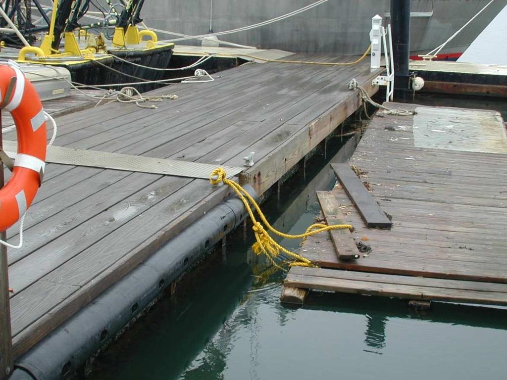
4 Fox Point Landing This commercial and recreational marine facility consists of 2 main (strong back) floats with 4 50ft steel finger floats off of these. One of these fingers is a Quarterbargeor boat house capable of meeting the storage needs of 4 separate entities. Presently these divided spaces are utilized by: 2 Sailing; 1 Marine Operations; 1 EEOS Dept. The type of floats that make up this system are a compilation of steel barge with wood framing top, some dating 30 years old, with the newest floats at 20 years old. The original smaller facility was chain moored and located 200yds to the west of it present location. The present system was licensed and enhanced with steel pilings in In 2007 the cove and fairway leading to the dock was dredged to a navigable depth of +/_ 8ft at mean low water. This dredging has enhanced water circulation and flushing to SavinHill Cove as well as permitted transit of fixed keel boats in/out of the facility at any tide range.

5 Fox Point Dock Fox Point docking facility is a year-round, multi-purpose facility located in SavinHill Cove (between Wheatley and McCormack towards the water). The basin is weather protected and offers an 80ft. main float with two 60ft finger floats for smaller vessels. Docking here is available for vessels up to 5ft draft. This facility is fortified with steel pilings, shore power, security gate and safety lighting.
6 Fox Point Float Replacement Narrative: Storm Damage to Fox Point: miles per hours winds out of the South East for 3 hours , during high tide, gusts up to 70 miles/hour. Problem began with Southeastern most steel pile collar tore away from the floating steel float. The pile collar ripped away from float creating a hole just above water line, with the wave action the float pitched and yawed dipping the hole into the water and ultimately filling the float. The first float sank quickly putting a lot of strain on the adjoining float and the mating hardware. We were unable to dislodge the second pontoon float from the now sunken float as this was now the only thing holding up the sunk float and the mating pins holding them together were jammed (see Slide #10). For the next hour the second float sustained damage until the storm subsided. Repairs: BTT Inc. (Marine Contractor) on scene w/crane barge and tug; lost moorings recovered by diving; pile collar caught under float but marked; photo's taken from above and below water. Float salvage completed on DMO (Division of Marine Operations) welded plate on a pile collar end and replaced pile collar. 3 moorings and lost pile collar recovered on by DMO divers. Summer 2007, DMO staff notice a significant loss in buoyancy of the damaged floats (see Slide #15) when more than 10 people stand on them, this poses a safety concern as these floats sink with added weight. Temporary repairs performed on DMO staff construct 4 wood cradles to contain 1-55 gal plastic sealed barrel each. The cradles were fastened under the damaged floats by DMO divers, then the barrels were flooded and put into position in the cradles, the barrels were then filled with air and sealed. Each barrel has a positive buoyancy of approximately 500psi.
7 Costs: $ 2 - steel floats submerged 92, wood/steel pontoon float submerged 6, power posts destroyed: Model #SPC36-4A 5, mooring anchors lost w/chain; size 500 Wood planking damaged/missing: 400 mooring lines parted 100 Cleats lost: Cell phone gal plastic barrels 200 Marine Contractor (Emergency salvage - Feb 06) 8,225 *Marine Contractor (re-set pilings -April 08) 10,000 FY 07 Budget appropriation (30,000) Total: 122,825 Funds has been spent from our Auxiliary account to cover the costs above with the exception of the $92,000. We received $30,000 thru the budget process last year to perform a design/study for a new facility. At this time we feel there is a more urgent safety need to replace the 2 most damaged floats (barges) with new ones, we would do this by using the $30,000 and ask for an additional $72,000 in capital fundingto cover the short fall of the $92,000 (barge bid) plus $10,000 to hire a *Marine Contractor to re-set 4 pilings.
8 Lowest acceptable bidder for 2 new steel floats (barges)


9 Day after storm; end floats are submerged out of picture


10 2 steel floats completely submerged (normally connected to black pilings and end connection of 1 pontoon float still connected

11 Pontoon float shown stressed with weight of submerged floats


12 Marine Contractor on scene 2 days after storm to salvage floats.

13 End floats shown re-floated and stable


14 Fox Point today after temporary repair measures performed on
15 Fox Point Dockage Red Area submerges when more than 10pp gather
16 The Next Wave
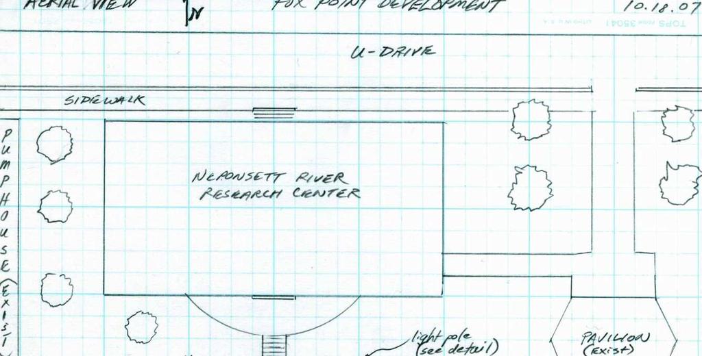
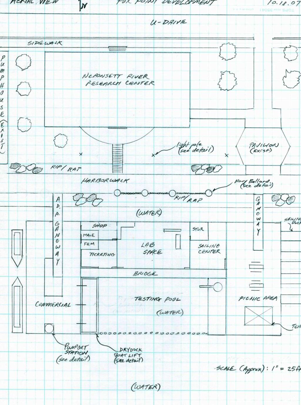
17 Visitors/Research Center Having a visible building on the water s edge is key to establishing a beachhead for marine research. This building would have many functions, at its core it would serve as a Visitors Center where there would be permanent displays showcasing the History of Columbia Point from the transformation of Kelly s landfill into the University park it is today. Revolving exhibits could include community initiatives from the varied community groups in our area. Faculty research projects on display could focus on finding solutions to real-world problems and integrating these efforts into the classroom. A marine science Visitor Center would create a unique, dynamic environment for lifelong exploration and discovery. The Visitor Center would encourage adults and children to enjoy marine science, the exhibits and programs could explain how scientific research enhances our ability to interpret the natural patterns that shape our world and enables us to better appreciate, manage, and sustain coastal marine resources. With a flow through salt water system interactive touching pools, aquaculture projects and marine animal life cycle demonstrations would be possible.
18
19 Marina Facility The Visitor Center along with an enhanced Marina facility could provide opportunities for conducting research on devices, methods, and concepts for informal science education that will advance the art of public education. A new two part Marina Facility, with a commercial side that could facilitate buoy deployment, remote sensing, autonomous underwater vehicle testing and chartering would serve as a catalyst for marine research activities as well as attract the neighboring scientific community. A Water Sports side with activities such as Sailing, Sea Kayak tours, and Kite Sailing would provide recreational activities for our students and community alike.
20
City of Pittsfield HARBORMASTER RULES AND REGULATIONS on docks
 City of Pittsfield HARBORMASTER RULES AND REGULATIONS on docks Definitions Dock: Any permanently fixed or floating structure extending from the upland into the water, capable of use for vessel mooring
HARBOR INFRASTRUCTURE INVENTORIES Caseville Harbor, Michigan
 HARBOR INFRASTRUCTURE INVENTORIES Caseville Harbor, Michigan Harbor Location: Caseville Harbor is located at the mouth of the Pigeon River on the east shore of Saginaw Bay, about 17 miles southwest of
City of Pittsfield Harbormaster APPLICATION FOR AN INDIVIDUAL MOORING PERMIT
 City of Pittsfield Harbormaster APPLICATION FOR AN INDIVIDUAL MOORING PERMIT INSTRUCTIONS: This application may only be used for requests to place lake moorings. This application must be completed in its
HARBOR INFRASTRUCTURE INVENTORIES Oak Orchard Harbor, New York
 HARBOR INFRASTRUCTURE INVENTORIES Oak Orchard Harbor, New York Harbor Location: Oak Orchard Harbor is located on the southern shore of Lake Ontario at the mouth of Oak Orchard Creek in the village of Point
Wexford Harbour. Yachting Guide. Navigation
 Wexford Harbour Yachting Guide Navigation This document supersedes all previous editions. Approvals: Yacht Club Committee April, 2015 Wexford Board of Directors April, 2015 # Date Section Revision 1 6.5.2015
Ketchikan Harbors Thomas Basin and Bar Point Harbor
 Ketchikan Harbors Thomas Basin and Bar Point Harbor Condition of Improvements 30 December 2014 Thomas Basin & Bar Point Harbors Ketchikan, Alaska (CWIS No. 000631 & 087071) Authorization (1) Rivers and
Public Notice U.S. Army Corps In Reply to Application Number CENAB-OP-RMS (NATIONAL HARBOR (FORMERLY PORT Baltimore District AMERICA])
![Public Notice U.S. Army Corps In Reply to Application Number CENAB-OP-RMS (NATIONAL HARBOR (FORMERLY PORT Baltimore District AMERICA])](/thumbs/89/100795623.jpg "Public Notice U.S. Army Corps In Reply to Application Number CENAB-OP-RMS (NATIONAL HARBOR (FORMERLY PORT Baltimore District AMERICA])") Public Notice U.S. Army Corps In Reply to Application Number of Engineers CENAB-OP-RMS (NATIONAL HARBOR (FORMERLY PORT Baltimore District AMERICA]) 88-01361 PN 14-05 Comment Period: January 16, 2014 to
Public Notice U.S. Army Corps In Reply to Application Number of Engineers CENAB-OP-RMS (NATIONAL HARBOR (FORMERLY PORT Baltimore District AMERICA]) 88-01361 PN 14-05 Comment Period: January 16, 2014 to
HARBOR INFRASTRUCTURE INVENTORIES West Harbor, OH
 HARBOR INFRASTRUCTURE INVENTORIES West Harbor, OH Harbor Location: West Harbor is located on the southern shore of Lake Erie in the township of Catawba Island, OH about 50 miles east of Toledo, OH. Authority:
HARBOR INFRASTRUCTURE INVENTORIES Lexington Harbor, Michigan
 HARBOR INFRASTRUCTURE INVENTORIES Lexington Harbor, Michigan Harbor Location: Lexington Harbor is located on the west shore of Lake Huron about 20 miles north of Port Huron, MI. Authority: Rivers & Harbors
Superyacht Seattle. Moorage Options
 Superyacht Seattle Moorage Options Terminal91 Terminal 91 2001 W Garfield St Seattle, WA 98199 206.787.3751 seaops@portseattle.org Terminal 91 is a secure facility located on Elliott Bay, at the north
City Council Workshop Agenda Item #3
 City Council Workshop Agenda Item #3 July 11, 2016 Portland Street Pier At the request of Councilor Morgan, the City Council will be talking about the Portland Street Pier facility located in Ferry Village.
HARBOR INFRASTRUCTURE INVENTORIES Marquette Harbor, Michigan
 HARBOR INFRASTRUCTURE INVENTORIES Marquette Harbor, Michigan Harbor Location: Marquette Harbor is located in Marquette Bay on the south shore of Lake Superior, 160 miles west of Sault Ste. Marie, MI and
5 Year Recreation Plan Proposed Amendment Marina/Harbor/Boat Launch
 5 Year Recreation Plan Proposed Amendment Marina/Harbor/Boat Launch The DNR and Waterways Commission requires certain elements addressing marinas/harbors to be included in a communities 5 Year Recreation
New Orleans Municipal Yacht Harbor
 New Orleans Municipal Yacht Harbor Marina Schematic Design Update 601 Poydras St., Suite 1860 New Orleans, LA, 70130 504-648-3560 Post-Katrina Municipal Yacht Harbor: Introduction The MYH was an approximate
ROV Development ROV Function. ROV Crew Navigation IRATECH SUB SYSTEMS 2010
 IR AT EC H SU B SY ST EM S 20 10 Remotely Operated Vehicle ROV INTRODUCTORY 2008 2008 1 KEY POINTS ROV Introductory ROV Development ROV Function Types of ROV ROV Crew Navigation ROV Components 2 ROV Development
Three Lines of Defence
 Three Lines of Defence 1. Prevent Grounding of Drifting Vessels 2. Contain Pollutants inside Damaged Hull 3. Remove Pollutants from Sunken Ship This is Miko Marine Miko Marine AS (Miko) is an innovative
HARBOR INFRASTRUCTURE INVENTORIES Port Sanilac Harbor, Michigan
 HARBOR INFRASTRUCTURE INVENTORIES Port Sanilac Harbor, Michigan Harbor Location: Port Sanilac Harbor is located on the west shore of Lake Huron, about 30 miles north of Port Huron, MI. Authority: Rivers
Redondo Beach Boat Launch Ramp Facility
 Redondo Beach Boat Launch Ramp Facility Feasibility Report for the California Department of Boating and Waterways 2015 Grant Cycle For the City of Redondo Beach Submitted by March 13, 2014 Table of Contents
Fort Hancock Sailing Center
 Response to the National Parks Service Request for Expressions of Interest to Redevelop Historic Structures at Fort Hancock in the Sandy Hook Unit of Gateway National Recreation Area Fort Hancock Sailing
Pioneer Array Micro-siting Public Input Process Frequently Asked Questions
 Pioneer Array Micro-siting Public Input Process Frequently Asked Questions The National Science Foundation (NSF) has completed the micro-siting of the moored array of the Ocean Observatories Initiative
2018 Beach Preservation Project Information
 QUICK FACTS Beach Renourishment to begin late April 2018 o U.S. Army Corps of Engineers project o Project Area: 8 th St. E. to end of E. Ashley Ave. o Project Length: 2 miles o Cost: $10,900,000 o Funding:
Request for Proposals L4865 The Pier 25 Marine Facility Concession in Hudson River Park (RFP) Questions & Answers.
 Questions & Answers.") Request for Proposals L4865 The Pier 25 Marine Facility Concession in Hudson River Park (RFP) Questions & Answers January 16, 2018 Q1: What is the current serviceability status of the moorings? A: All
Request for Proposals L4865 The Pier 25 Marine Facility Concession in Hudson River Park (RFP) Questions & Answers January 16, 2018 Q1: What is the current serviceability status of the moorings? A: All
HARBOR INFRASTRUCTURE INVENTORIES Fairport Harbor, OH
 HARBOR INFRASTRUCTURE INVENTORIES Fairport Harbor, OH Harbor Location: Fairport Harbor is located at the mouth of the Grand River on the southern shore of Lake Erie in the city of Fairport, OH, approximately
Hydrographic Surveying Methods, Applications and Uses
 Definition: Hydrographic Surveying Methods, Applications and Uses It is the branch of surveying which deals with any body of still or running water such as a lake, harbor, stream or river. Hydrographic
Provisions for Moorings
 Provisions for Moorings Tasman Resource Management Plan Summary Guide No. 11 Current: July 2013 1. Introduction Structures and occupation of the coastal marine area (CMA) are managed to control the location
Preventing Damage to Harbour Facilities and. Ship Handling in Harbours PART 2 INDEX
 Preventing Damage to Harbour Facilities and Ship Handling in Harbours PART 2 INDEX 1 Vessel handling is based on the basic knowledge that a vessel floats in the water and returns to its original position
CITY OF NEWPORT BEACH HARBOR COMMISSION STAFF REPORT
 CITY OF NEWPORT BEACH HARBOR COMMISSION STAFF REPORT Agenda Item No. 2 TO: FROM: SUBJECT: HARBOR COMMISSION Harbor Resources Division (City Manager's Office) Chris Miller, Harbor Resources Supervisor,
Fully Submersible Heavy Lift Vessel
 Fully Submersible Heavy Lift Vessel Arnbjorn Joensen Aberdeen Maritime Branch (28th January 2015) PRESENTATION Introduction to the Subsea Deployment Vessel Installation method Tank test video Potential
Company presentation
 Company presentation Problem definition Creative thinking Introduction Miko Marine was founded in 1996 based on the magnetic patch to stop water ingress and oil spill. Miko Plaster solutions have since
1-22. KETCHIKAN, ALASKA (Thomas and Bar Point Basins) (CWIS NOS & 87071) Condition of Improvement 30 September 2007
 (CWIS NOS & 87071) Condition of Improvement 30 September 2007") KETCHIKAN HARBOR 1-22 KETCHIKAN, ALASKA (Thomas and Bar Point Basins) (CWIS NOS. 00631 & 87071) Condition of Improvement 30 September 2007 AUTHORIZATION: (1) Rivers and Harbors Act, 3 July 1930 (House
KETCHIKAN HARBOR 1-22 KETCHIKAN, ALASKA (Thomas and Bar Point Basins) (CWIS NOS. 00631 & 87071) Condition of Improvement 30 September 2007 AUTHORIZATION: (1) Rivers and Harbors Act, 3 July 1930 (House
Port Sections Guide Section 01
 s Guide 01 Cow Bay Marina Date 10/1/2016 Position (lat / lon) Minimum controlled water depth Chart datum Range of water densities Tidal range alongside Bottom type Dredging regime Distance pilot station
Break in the Bahamas. Cutters Head to the Caribbean to Wire Saw Sunken Pier. A 25-foot by 25-foot steel pier section had sunk into the water.
 Break in the Bahamas Cutters Head to the Caribbean to Wire Saw Sunken Pier A 25-foot by 25-foot steel pier section had sunk into the water. CONCRETE CASES Divers were used to inspect the damaged structure
IPSWICH. Port Safety Notice
 IPSWICH Port Safety Notice 19th October 2018 1 Associated British Ports Ipswich Port Safety Notice to Masters Introduction: This Port Safety Notice has been developed and communicated to provide general
Storm Preparedness Plan for Manchester, Massachusetts Issued by the Manchester Harbormaster Department. A.
 Manchester-by-the-Sea Harbormaster Harbormaster 10 CENTRAL ST. MANCHESTER, MASSACHUSETTS 01944-1399 OFFICE (978)526-7832 CELL (978)473-2520 FAX (978)526-2001 HARBORMASTER@MANCHESTER.MA.US. Storm Preparedness
Multi-Purpose Workboats and Vessels. Marine Engineering and Construction. Salvage and Wreck Removal. Marine Consultancy Services
 Multi-Purpose Workboats and Vessels Marine Engineering and Construction Salvage and Wreck Removal Marine Consultancy Services Marine Expertise and Support We are a progressive company with more than 50
2. The reference depth is an important measurement for basic flotation testing?
 1. The definition of the term Deadweight is a. The maximum weight capacity minus the persons capacity for outboards b. The maximum weight capacity minus the persons capacity for inboards, sterndrives,
Delaware Chapter Surfrider Foundation - Indian River Inlet Monitoring
 Delaware Chapter Surfrider Foundation - Indian River Inlet Monitoring In 2012, the Delaware Surfrider Foundation Chapter formed the Surf Quality and Access Committee to focus on issues such as surf spot
The development of the historical harbour of Paphos, Cyprus H.J. van Wijhe*, M. Meletiou^ Division, P.O. Box 152, 8300 AD Emmeloord, The Netherlands
 The development of the historical harbour of Paphos, Cyprus H.J. van Wijhe*, M. Meletiou^ Division, P.O. Box 152, 8300 AD Emmeloord, The Netherlands Abstract The harbour of Paphos originates from ancient
Reliable partners for over 100 years delivering solutions worldwide CAGE FARMING EQUIPMENT
 Reliable partners for over 100 years delivering solutions worldwide CAGE FARMING EQUIPMENT SUBMERSIBLE AND FLOATING CAGES OVERVIEW SUBMERSIBLE CAGES The use of submersible cages allows farmers to develop
Anchoring Is Important
 BCC Sailing Classes - Third Theory Anchoring Anchoring Is Important 1 The Anchor is your last resort. Anchoring Keep off a lee shore. Needs to be shaped (type of anchor) to bury in the type of bottom for
Are All Floating Structures Vessels? Stephanie Showalter, J.D. Sea Grant Law Center University of Mississippi
 Are All Floating Structures Vessels? Stephanie Showalter, J.D. Sea Grant Law Center University of Mississippi Why Does Vessel Status t Matter? Seamen vs. Longshoremen Injured seaman may bring negligence
Number Details Action
 Minutes Present: Gosford City Council, RHDHV & Public Stakeholders. Apologies: From: Karen O'Mara & James Donald Date: Wednesday, 11 May 2016 Location: Gosford Sailing Club Copy: Our reference: M&APA1337M002F01
CITY OF FERNANDINA BEACH, FLORIDA
 CITY OF FERNANDINA BEACH, FLORIDA ADDENDUM ONE FOR INVITATION TO BID ITB #16-02 EGANS CREEK FISHING PIER AND KAYAK LAUNCH Prepared By: City of Fernandina Beach 204 Ash Street Fernandina Beach, FL 32034
NAUTICAL TERMINOLOGY
 It s important to have a basic understanding of common nautical terms associated with the parts, positions and directions of your vessel. Knowing these terms will make it easier to communicate with people
Plot the Path. Mary Anne Otten. lesson three
 Plot the Path Mary Anne Otten lesson three Subject/Grade: Grade 2, Math, Social Studies, Science Duration: one class period Materials needed: Per class: Day the Great Lakes Drained Away by Charles Ferguson
Washington State Parks comments to the Draft Clallam County Shoreline Master Program Update Consistency Review June 3, 2011
 Washington State Parks comments to the Draft Clallam County Shoreline Master Program Update Consistency Review June 3, 2011 Pg 10 Public access is typically discussed as a requirement placed on facilities
Innovative and Robust Design. With Full Extension of Offshore Engineering and Design Experiences.
 Innovative and Robust Design by VL Offshore With Full Extension of Offshore Engineering and Design Experiences www.vloffshore.com Y Wind Semi Designed by VL Offshore The Y Wind Semi platform (foundation)
National Maritime Center
 National Maritime Center Providing Credentials to Mariners Q301 Rules of the Road-Inland (Sample Examination) Page 1 of 19 Choose the best answer to the following Multiple Choice Questions. NO reference
MOORING INFORMATION FOR BOAT OWNERS AT RGYC
 MOORING INFORMATION FOR BOAT OWNERS AT RGYC Boat owners with vessels stored in the RGYC Marina are encouraged to review the way their vessel is moored in its pen. Insurance All vessel owners must have
STUDENT MEMBERSHIP POLICIES & PROCEDURES
 STUDENT MEMBERSHIP POLICIES & PROCEDURES OFFICE HOURS 9am to sunset, April 30 th through October 28 th, 2018 (Offseason hours are Monday to Friday from 10am to 5pm) GENERAL The purpose of a Student Membership
Port Elgin Harbour Strategic Assessment. Study undertaken by TOURISTICS and Shoreplan Engineering Limited
 Study undertaken by TOURISTICS and Shoreplan Engineering Limited 1 Study included: Review of existing recreational boating facilities in Bruce and Grey Counties An analysis of trends in recreational boating
BACKGROUND TO STUDY CASE
 BACKGROUND TO STUDY CASE German Aerospace Center (DLR) is using Andøya Rocket Range for a sounding rocket campaign. On 27th October 2005 a 300 kg payload (SHEFEX) was launched Due do a technical problems
HARBOR INFRASTRUCTURE INVENTORIES Cheboygan Harbor, Michigan
 HARBOR INFRASTRUCTURE INVENTORIES Cheboygan Harbor, Michigan Harbor Location: Cheboygan Harbor is located at the mouth of the Cheboygan River, emptying into western Lake Huron approximately 16 miles southeast
Initial Design of Offshore Floating Marina System
 Initial Design of Offshore Floating Marina System H. Chung* T. W. Oh* S. Namgoong* S. B. Kim* C. H. Jo** *Ocean Space Inc., Seoul, Korea **Naval Architecture and Ocean Engineering Dept., Inha University,
A Single-Point Mooring System for Direct Pumpout of Hopper Dredges
 ..-0. -..- DRP-3-08 November 1992 Dredging Technical Research Notes A Single-Point Mooring System for Direct Pumpout of Hopper Dredges Purpose This technical note describes a direct pumpout (DPO) system
INCIDENT REPORT OASIS SAILING CLUB
 1) BOAT DESCRIPTION INCIDENT REPORT OASIS SAILING CLUB Name: Make: CATALINA Length: 34' 6" Registration: Model: CATALINA 34 MKII Type: SLOOP Hull ID: Year Built: Motor: 30 hp Diesel 2) BOAT OWNER Friends
Coastal Harbors and Waterways, NC (Shallow Draft Navigation) (O&M)
 (O&M)") Coastal Harbors and Waterways, NC (Shallow Draft Navigation) (O&M) Shallow draft coastal harbors include a subsistence harbor at Silver Lake CONGRESSIONAL DISTRICT: NC 3, 7 DATE: 23 April 2018 1. AUTHORIZATION:
Coastal Harbors and Waterways, NC (Shallow Draft Navigation) (O&M) Shallow draft coastal harbors include a subsistence harbor at Silver Lake CONGRESSIONAL DISTRICT: NC 3, 7 DATE: 23 April 2018 1. AUTHORIZATION:
In this issue: Rena operational roles and responsibilities. Issue 13 September 2013
 Issue 13 September 2013 In this issue: Rena operational roles and responsibilities An update on Rena Recovery activities What s happening with wildlife Operational update on the wreck from the owners Cutting
U. S. Coast Guard Sector Boston Merrimack River Approach and Entrance, MA. Waterways Management Survey
 U. S. Coast Guard Sector Boston Merrimack River Approach and Entrance, MA. Waterways Management Survey The Waterways Analysis and Management Survey (WAMS) process is an essential component of both the
SAFETY OF NAVIGATION STANDARDS IN THE PORTS OF NAUTICAL TOURISM WITH A SPECIAL FOCUS ON THE MAINTENANCE OF THE PORT ORDER
 SAFETY OF NAVIGATION STANDARDS IN THE PORTS OF NAUTICAL TOURISM WITH A SPECIAL FOCUS ON THE MAINTENANCE OF THE PORT ORDER Ranka Petrinović, Ph. D, Full Professor Nikola Mandić, Ph. D, Assistant Professor
The Matrix: All Safety Related Signs found in USACE Sign Program
 The Matrix: All Safety Related Signs found in USACE Sign Program Updated January 2011 The Danger, Caution, and Warning safety sign legends highlighted below in red or yellow have been approved by HQUSACE
Reef Ball Designed Reefs Beaches, Turks and Caicos Final Report
 Reef Ball Designed Reefs Beaches, Turks and Caicos Final Report The Beaches Reef Ball Designed Reef Project has now been completed and being utilized by Beaches clients. As per the proposal submitted,
Robo-Nemo. Educating youth about ocean research! sponsored by the. National Science Foundation
 Robo-Nemo Educating youth about ocean research! sponsored by the National Science Foundation created by Monique Chyba and Ryan N. Smith University of Hawaii at Manoa Department of Mathematics in conjunction
Do you have any reef related concerns or specific problems you would like to share?
 Submitted County Do you have any reef related concerns or specific problems you would like to share? Do you have any suggestions about how to Improve the Our Florida Reefs Community Planning Process? What's
North Sea,
 (RDM-collectie Johan Journée) John s Homepage by John H. Mitchell North Sea, 1974-1976 http://home.earthlink.net/~john280z/photos81.htm Note: These photos are scanned-in 30 year old photos, not 100% quality.
21st International Conference of The Coastal Society
 21st International Conference of The Coastal Society Fishtown at Leland, Michigan, owned by the Fishtown Preservation Society, http://www.fishtownpreservationsociety.org (photo courtesy of Keith Burnham,
USE OF REELS IN DIVING
 USE OF REELS IN DIVING There have been several different types of reel developed for both commercial and recreational use. This guide is compiled to aid in the use of reels in two distinct techniques,
Coastal Harbors and Waterways, NC (Shallow Draft Navigation) (O&M)
 (O&M)") Coastal Harbors and Waterways, NC (Shallow Draft Navigation) (O&M) Shallow draft coastal harbors include a subsistence harbor at Silver Lake CONGRESSIONAL DISTRICT: NC 3 and 7 DATE: 23 February 2015 1.
Coastal Harbors and Waterways, NC (Shallow Draft Navigation) (O&M) Shallow draft coastal harbors include a subsistence harbor at Silver Lake CONGRESSIONAL DISTRICT: NC 3 and 7 DATE: 23 February 2015 1.
CONTENTS AIRBERTH OWNER S MANUAL I 3
 CONTENTS 1 Introduction...4 2 Suitable Mooring Locations...5 3 Operating Procedures...6 3.1 Safety Checklist...6 3.2 Store your Boat with AirBerth...7 3.3 Launch your Boat with AirBerth...8 3.4 Hull Rinsing
HARBOR INFRASTRUCTURE INVENTORIES Harbor Beach Harbor, Michigan
 HARBOR INFRASTRUCTURE INVENTORIES Harbor Beach Harbor, Michigan Harbor Location: Harbor Beach Harbor is located on the west shore of Lake Huron about 60 miles north of Port Huron, MI. Authority: Rivers
APPENDIX D REAL ESTATE PLAN
 NAVIGATION IMPROVEMENTS SITKA HARBOR, ALASKA CHANNEL ROCK BREAKWATERS DRAFT DEFICIENCY CORRECTION EVALUATION REPORT APPENDIX D REAL ESTATE PLAN JANUARY 2011 REAL ESTATE PLAN FOR SITKA HARBOR, ALASKA CHANNEL
ST. LOUIS SECTION PROJECT OF THE YEAR AWARD
 ST. LOUIS SECTION PROJECT OF THE YEAR AWARD Originality and Innovation The St. Louis Harbor Project is located in the Upper Mississippi River between the entrance to the Chain of Rocks Canal at River
UCI NAUTICAL DEPARTMENT
 Page 1 UCI NAUTICAL DEPARTMENT GENERAL RULES 1. ELIGIBILITY - To be eligible to select/use a slip at a UCI facility one must: BE A RESIDENT OF ULMSTEAD ESTATES BE A UCI MEMBER IN GOOD STANDING BE A MEMBER
Eelgrass Survey Reporting Form 2222 Channel Road Newport Beach, CA Eelgrass (Zostera marina) Survey
 Survey") Eelgrass Survey Reporting Form 2222 Channel Road Newport Beach, CA 92660 Eelgrass (Zostera marina) Survey Survey Date: July 19th, 2013 Report Date: July 26 th, 2013 Prepared by: Coastal Resources Management,
Eelgrass Survey Reporting Form 2222 Channel Road Newport Beach, CA 92660 Eelgrass (Zostera marina) Survey Survey Date: July 19th, 2013 Report Date: July 26 th, 2013 Prepared by: Coastal Resources Management,
MAC Transit Advisories as of April 30, 2018
 MAC Transit Advisories as of April 30, 2018 The Mariners Advisory Committee for the Bay and River Delaware was established in October 1964. Its members and associate members are mainly comprised of master
Plot the Path into the Harbor
 Plot the Path into the Harbor By Mary Anne Otten, Rudyard Area Schools and Joan Chadde, Michigan Technological University Subject/Grade: Grade 3 6, Math, Social Studies, Science Duration: 35 minutes Lesson
Harbor Safety Committee HEAVY WEATHER (WX)
") HEAVY WEATHER (WX) SOC Quick Reference Risk Petroleum transfers Mooring buoys- Operating Policies and Weather Criteria General mooring policies, breakaway prevention Derelict and unattended vessels (abandoned
HEAVY WEATHER (WX) SOC Quick Reference Risk Petroleum transfers Mooring buoys- Operating Policies and Weather Criteria General mooring policies, breakaway prevention Derelict and unattended vessels (abandoned
HARBOR INFRASTRUCTURE INVENTORIES Muskegon Harbor, Michigan
 HARBOR INFRASTRUCTURE INVENTORIES Muskegon Harbor, Michigan Harbor Location: Muskegon Harbor is located on the east shore of Lake Michigan, 114 miles northeast of Chicago, IL. Authority: River & Harbor
Astrolabe Reef Access Plan Stakeholder Presentation
 Astrolabe Reef Access Plan Stakeholder Presentation *Rena s bow thruster approx 18m Agenda Overview Access Plan Introduction State of the Reef & Wreck Site What to Expect Timetable & Activity Questions
LAW AND PUBLIC SAFETY BOAT REGULATION COMMISSION MOTOR VEHICLE COMMISSION. Readoption with Amendments: N.J.A.C. 13:82. Boating Regulations
 LAW AND PUBLIC SAFETY BOAT REGULATION COMMISSION MOTOR VEHICLE COMMISSION Readoption with Amendments: N.J.A.C. 13:82 Boating Regulations Proposed: August 17, 2009 at 41 N.J.R. 3033(a). Adopted: November
NOTICE TO MARINERS. No 60(T) of Port of Southampton Southampton Boat Show, River Test 16 th to 25 th September 2016
 of Port of Southampton Southampton Boat Show, River Test 16 th to 25 th September 2016") NOTICE TO MARINERS No 60(T) of 2016 Port of Southampton Southampton Boat Show, River Test 16 th to 25 th September 2016 NOTICE IS HEREBY GIVEN that the Southampton Boat Show will take place on and adjacent
NOTICE TO MARINERS No 60(T) of 2016 Port of Southampton Southampton Boat Show, River Test 16 th to 25 th September 2016 NOTICE IS HEREBY GIVEN that the Southampton Boat Show will take place on and adjacent
Development of Self-Installing Deepwater Spar. Ashit Jadav February 2017
 Development of Self-Installing Deepwater Spar Ashit Jadav February 2017 Contents Introduction & Background ACE Spar breakdown Installation Sequence Main particulars, Hull design and Weight control Stability
Leg 1: Sucia Island to La Conner Marina ( Distance = 29.3 nm. La Conner Marina Contact Info:
 Double Southern Comfort Cruise Seattle Extension July 9 July 22, 2012 Leg 1: Sucia Island to La Conner Marina (www.portofskagit.com/la-conner-marina) Distance = 29.3 nm La Conner Marina Contact Info: Telephone:
MIKE Release General product news for Marine software products, tools & features. Nov 2018
 MIKE Release 2019 General product news for Marine software products, tools & features Nov 2018 DHI 2012 MIKE 3 Wave FM New advanced phase-resolving 3D wave modelling product A MIKE 3 FM Wave model - why?
Perched Box Caisson Overview. January 2014
 Perched Box Caisson Overview January 2014 Why perched box caissons? Perched box caissons are used to construct the portion of the river piers that will support the steel arch spans Construction can occur
1-32 NOME HARBOR, ALASKA (CWIS NOS , 87755, 12270, & 10422) Condition of Improvement 30 September 2012
 Condition of Improvement 30 September 2012") NOME HARBOR 1-32 NOME HARBOR, ALASKA (CWIS NOS. 72742, 87755, 12270, & 10422) Condition of Improvement 30 September 2012 AUTHORIZATION: (1) Rivers and Harbors Act, 8 August 1917 (House Doc. 1932, 64th
NOME HARBOR 1-32 NOME HARBOR, ALASKA (CWIS NOS. 72742, 87755, 12270, & 10422) Condition of Improvement 30 September 2012 AUTHORIZATION: (1) Rivers and Harbors Act, 8 August 1917 (House Doc. 1932, 64th
Divemaster. Divemaster
 Divemaster OVERVIEW AND QUALIFICATIONS The NAUI Divemaster rating is the highest NAUI leadership level certification with the exception of instructor. The program is designed to train experienced and knowledgeable
REVISED SILT CURTAIN DEPLOYMENT PLAN
 Contract No.: HY/2009/11 Central Wanchai Bypass, North Point Reclamation REVISED SILT CURTAIN DEPLOYMENT PLAN Name Prepared by: China Harbour Engineering Co., Ltd. China Road and Bridge Corporation Joint
COAST GUARD ADVISORY NOTICE (CGAN ) To: Distribution Date: September 1, 2017
 To: Distribution Date: September 1, 2017") Commander United States Coast Guard Sector New York 212 Coast Guard Drive Staten Island, NY 10305 Staff Symbol: (spw) Phone: (718) 354-2353 Fax: (718) 354-4190 COAST GUARD ADVISORY NOTICE (CGAN 2017-016)
Commander United States Coast Guard Sector New York 212 Coast Guard Drive Staten Island, NY 10305 Staff Symbol: (spw) Phone: (718) 354-2353 Fax: (718) 354-4190 COAST GUARD ADVISORY NOTICE (CGAN 2017-016)
Coastal Harbors and Waterways, NC (Shallow Draft Navigation) (O&M)
 (O&M)") Coastal Harbors and Waterways, NC (Shallow Draft Navigation) (O&M) Shallow draft coastal harbors include a subsistence harbor at Silver Lake CONGRESSIONAL DISTRICT: NC 3 and 7 DATE: 23 February 2015 1.
Coastal Harbors and Waterways, NC (Shallow Draft Navigation) (O&M) Shallow draft coastal harbors include a subsistence harbor at Silver Lake CONGRESSIONAL DISTRICT: NC 3 and 7 DATE: 23 February 2015 1.
VISITING BOATS INFORMATION
 VISITING BOATS INFORMATION 2017 Seaham Harbour Marina is a joint venture between the Victoria Group and Durham County Council Marina Management Unit 10, The Waterside Seaham Harbour Marina, Seaham County
GUIDANCE NOTICE. Unpowered Barges. Definition. General. Risk assessment. Application. Safety Management. Compliance
 GUIDANCE NOTICE Unpowered Barges Definition Unpowered Barge - a vessel that is not propelled by mechanical means and is navigated by a powered vessel that moves it by pushing or towing. General This notice
EXPEDITION ADVENTURE PART 2: HIGHER RESOLUTION RANGE SEISMIC IMAGING TO LOCATE A SUNKEN PIRATE SHIP OFF ILE ST MARIE.
 EXPEDITION ADVENTURE PART 2: HIGHER RESOLUTION RANGE SEISMIC IMAGING TO LOCATE A SUNKEN PIRATE SHIP OFF ILE ST MARIE. Jakob B.U. Haldorsen, and Douglas E. Miller, Schlumberger-Doll Research, Ridgefield,
TOWN OF DENNIS 10 YR COMPREHENSIVE DREDGE PERMIT SEPTEMBER 10, 2013
 TOWN OF DENNIS 10 YR COMPREHENSIVE DREDGE PERMIT SEPTEMBER 10, 2013 WHAT IS IT? ALL NECESSARY PERMITS FOR DREDGING FOR PORTIONS OF BASS RIVER, SWAN POND RIVER, SESUIT HARBOR AND CHASE GARDEN CREEK ONE
Teaching students about how technology enables science through building Aquarius Habitats.
 Lesson Plan Aquarius Technology: Building an Underwater Habitat Focus Teaching students about how technology enables science through building Aquarius Habitats. Focus Questions Why build an underwater
A buoy, for example is an aid to navigation. Aids to navigation include many types of buoys as well as day beacons, range markers, and lighthouses.
 This online study guide has been approved by Transport Canada strictly on the basis that it meets the requirements of the Standard for Pleasure Craft Operator Testing over the Internet (TP 15080E) and
Use of Underwater Dry Welding for In Situ Repair to Offshore Structures. Sabine Powell 02/12/2016
 Use of Underwater Dry Welding for In Situ Repair to Offshore Structures Sabine Powell engineering@neptunems.com 02/12/2016 In Situ Welding Steel Structures Suitability of Repair Methods Mobile Offshore
Procedure for Setting a Mooring
 The information below was provided by DSC member Jim Simons. Procedure for Setting a Mooring Here's a note he sent to Good Old Boat magazine a couple of years ago, which hits the high points. 1. All components
Mooring Solutions for Yachts
 Product Presentation Mooring Solutions for Yachts DualDocker GmbH Gewerbegebiet Nord 6 5222 Munderfing AUSTRIA www.dualdocker.com Problem Conventional Mooring Systems Heavy, dirty mooring ropes Inefficient
GERMAN RENEWABLE SHIPBROKERS S GERMAN RENEWABLE VESSEL PORTFOLIO ANY VESSEL ANYTIME
 GERMAN VESSEL PORTFOLIO ANY VESSEL ANYTIME YOU THINK OFFSHORE WE FOLLOW YOUR THOUGHTS! A vessel for construction works at sea? An installation vessel for wind turbine generators or a sale and purchase