The Ike Dike. A Coastal Barrier Protecting the. Hurricane Storm Surge. Protecting the Houston/Galveston Region from Hurricane Storm Surge
|
|
|
- Jesse Kelly
- 5 years ago
- Views:
Transcription


1 The Ike Dike A Coastal Barrier Protecting the Houston/Galveston A Coastal Barrier Region from Hurricane Storm Surge Protecting the Houston/Galveston Region from Hurricane Storm Surge
2 The Houston/Galveston Region Nationally-important population and economic Center Considerable infrastructure near sea level with storm surges channeled up the Bay Supports largest petrochemical complex in US Port of Houston alone generates over $178 Billion in economic activity annually Galveston Bay provides valuable ecosystem services Affected by a major storm about every 15 years Large-scale evacuations are increasingly difficult, especially for Hurricanes that quickly increase in intensity and/or change direction

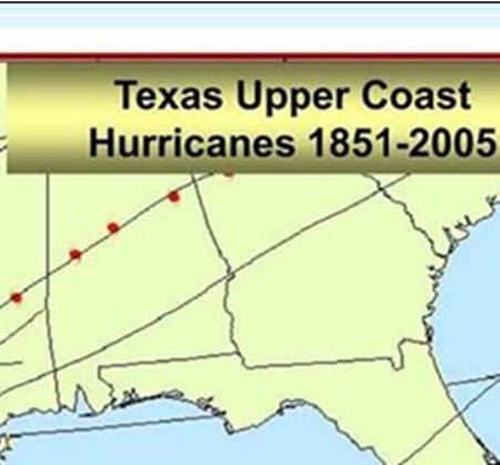
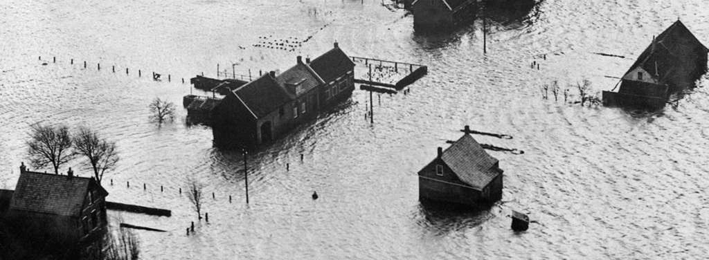
3 Hurricane Rita killed three people. The three day mass evacuation 1932 leading up hurricane to Rita's landfall killed image 108.


4

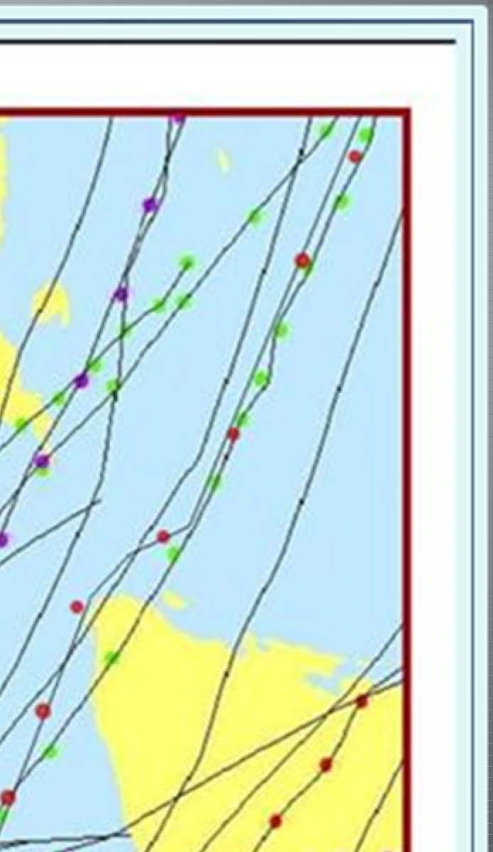
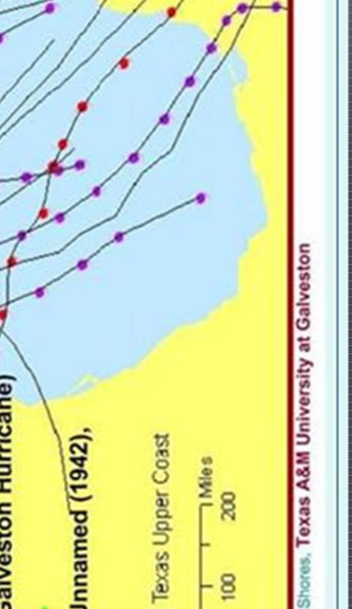
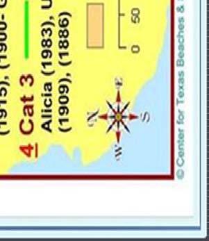
5 Time of forming Cat 3 to landfall- 6+ hours Within 250-miles of the landfall location hours Center for Texas Beaches & Shores, Texas A&M University at Galveston

6 Chasing Ike Sheltering Community Staging Area Evacuating Area NHC Advisories Sept Source: Dr. Gordon Wells, UTA
7 If farther west, many more lives lost, much more damage


8

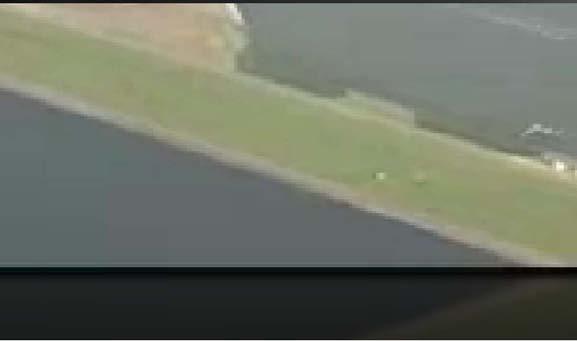
9


10


11 Greater New Orleans is now protected by a 133 mile parameter of levees, flood walls and gated barriers. The total cost of Greater New Orleans Hurricane and Storm Risk Reduction System so far is 14.5 billion dollars. The strategy is to keep massive surges from entering the system by shortening the outer protection needed by using 4 gated passages. The System was started in 2008 and achieved 100 yr surge event protection in June 2011.

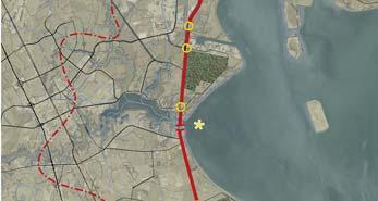
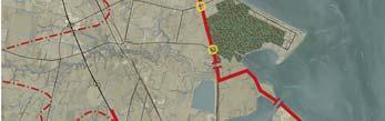
12 The strategy is to keep the ocean surge out of Galveston Bay by using a gated coastal barrier (the Ike Dike) Houston Ship Channel High Island Bolivar Roads Existing Seawall Intracoastal Waterway Coastal Spine San Luis Pass
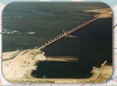
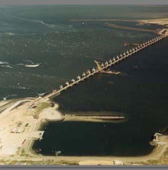
13 Deltaworks, New Orleans, Ike Dike All shorten the perimeter as much as possible All keep the surge out of internal waters All use gates to accomplish this


14 Houston Ship Channel High Island The first component of the Ike Dike already exists the Galveston Seawall Bolivar Roads Existing Seawall Intracoastal Waterway San Luis Pass

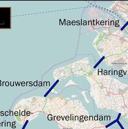
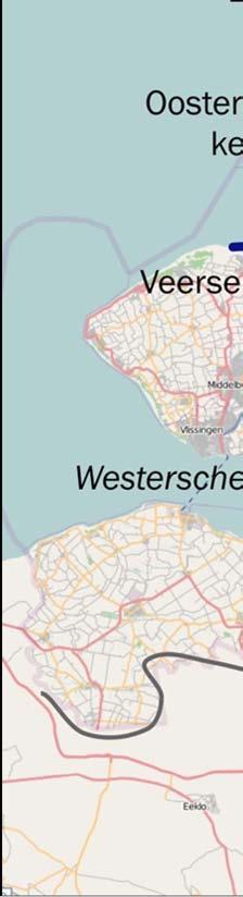
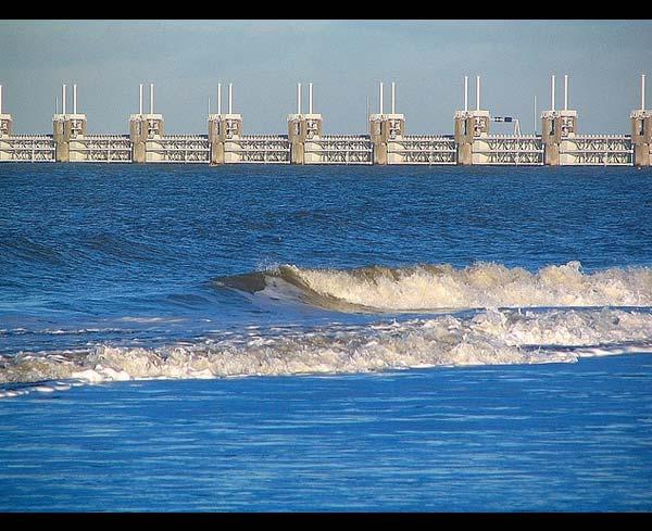
15 Houston Ship Channel High Island The second component - Land Extensions of the protection afforded by the Seawall Bolivar Roads Existing Seawall Intracoastal Waterway San Luis Pass


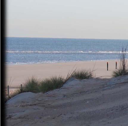
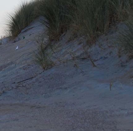

16 Revetments can be hidden to look natural


17 The third component Flood Gates Houston Ship Channel High Island Bolivar Roads Existing Seawall Intracoastal Waterway San Luis Pass
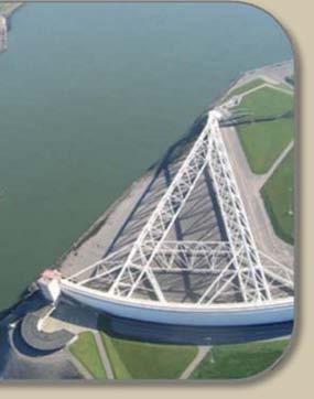
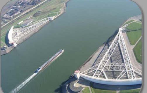
18 The Galveston Gates Must not impede navigation Must allow water circulation into the bay under normal conditions But close quickly when a hurricane approaches to provide a 17ft higher-than-sea-level barrier across Bolivar Roads Can we use existing technology?


19

20 Start of Gate Closing Texas Delegation


21 A Bay circulation solution


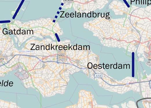
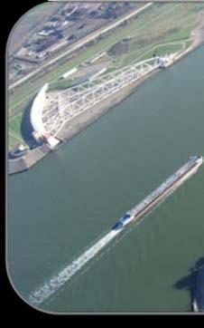
22 The Netherlands Storm Surge Barrier in Action

23 Possible New York Barrier

24 All together it forms a coastal spine But will the Ike Dike, suppress massive surges? Houston Ship Channel High Island Bolivar Roads Existing Seawall Intracoastal Waterway San Luis Pass

25 Simulations: Ike s Surge without an Ike Dike The University of Texas Gordon Wells, Jennifer Profit, Clint Dawson
26 Simulations: Ike s Surge with an Ike Dike The University of Texas Gordon Wells, Jennifer Profit, Clint Dawson

27 Simulations: Difference in Ike s Surge with and without an Ike Dike Gordon Wells, Jennifer Profit, Clint Dawson
28 Ike Dike Additional Characteristics 2 System can be leaky unlike New Orleans, Holland Can use Galveston Bay as a retention pond Only needs to hold maximum surge for a few hours Doesn t harm neighboring communities Doesn t lead to a race for more and higher dikes

29 Ike Dike Additional Characteristics 1 Stops the Surge at the coast where it s the smallest Protects strategic assets of national importance Protects Bay s Natural Resources Occupies the minimum foot print for comprehensive protection Protects every community rich or poor Entire region recovers quickly
30 A Coastal Spine Suppresses Surge and is Technically Feasible Economically Sound Environmentally Friendly, and Socially Just It Should Be Part of Our Surge Suppression Strategy
31 Research Team Economics Institute for Regional Forecasting at UH, Dr Bill Gilmer Modeling Homeland Security Center of Excellence at Jackson State, Dr Robert Whalin and Dr Ty Wamsley, USACE/ERDC Barrier Design Delft Technical University, Drs. Bas Jonkman and Mathijs van Ledden Overall Flood Risk Reduction/Project Coordination TAMUG, Drs. Sam Brody and Bill Merrell
32 Research Approach/Schedule Economic Study ASAP Modeling to Inform Economic Study and Barrier Design Dutch Dialogues And to Understand Galveston Bay s Roles Test Barrier Conceptual Designs Better Cost Estimates Costs/Benefits
33 Chemical Plants Affected (Percent U.S. Capacity Shut Down at Peak) Ethylene Steam Cracker: 58.5% RG Propylene: 30.7% Benzene: 68.5% Polyethylene: 63.0% Styrene: 85.3% Butadiene: 95.8% By Hurricane Rita Data from CMAI, Inc and expressed as percent of North American Capacity


34

35 La Porte Seabrook Bacliff/San Leon


36 Levee System Ship Channel Gate
The Ike Dike. A Coastal Barrier Protecting the. Hurricane Storm Surge. Protecting the Houston/Galveston Region from Hurricane Storm Surge
 The Ike Dike A Coastal Barrier Protecting the Houston/Galveston A Coastal Barrier Region from Hurricane Storm Surge Protecting the Houston/Galveston Region from Hurricane Storm Surge If farther west, many
SURGE SUPPRESSION ACHIEVED BY DIFFERENT COASTAL SPINE (IKE DIKE) ALIGNMENTS. Bruce A. Ebersole, Thomas W. Richardson and Robert W.
 ALIGNMENTS. Bruce A. Ebersole, Thomas W. Richardson and Robert W.") SURGE SUPPRESSION ACHIEVED BY DIFFERENT COASTAL SPINE (IKE DIKE) ALIGNMENTS Abstract Bruce A. Ebersole, Thomas W. Richardson and Robert W. Whalin, Jackson State University, Jackson, Mississippi The primary
SURGE SUPPRESSION ACHIEVED BY DIFFERENT COASTAL SPINE (IKE DIKE) ALIGNMENTS Abstract Bruce A. Ebersole, Thomas W. Richardson and Robert W. Whalin, Jackson State University, Jackson, Mississippi The primary
Important note To cite this publication, please use the final published version (if applicable). Please check the document version above.
. Please check the document version above.") Delft University of Technology Galveston Bay Area Land Barrier preliminary design van Berchum, Erik; de Vries, P.A.L.; de Kort, R.P.J. Publication date 2016 Document Version Publisher's PDF, also known
Delft University of Technology Galveston Bay Area Land Barrier preliminary design van Berchum, Erik; de Vries, P.A.L.; de Kort, R.P.J. Publication date 2016 Document Version Publisher's PDF, also known
DELAWARE S VULNERABLE COASTAL AREAS. DELAWARE INLAND BAYS and DELAWARE BAY RECONNAISSANCE STUDY
 DELAWARE S VULNERABLE COASTAL AREAS and the DELAWARE INLAND BAYS and DELAWARE BAY RECONNAISSANCE STUDY Kimberly K. McKenna, PG Delaware Dept. of Natural Resources & Environmental Control Division of Watershed
Modeling Sediment Transport Along the Upper Texas Coast
 Modeling Sediment Transport Along the Upper Texas Coast David B. King Jr. Jeffery P. Waters William R. Curtis Highway 87 roadbed, Jefferson County Galveston District Corps Sabine Pass to San Luis Pass
The Texas Gulf Coast Overview and Outlook
 The Texas Gulf Coast Overview and Outlook Jesse Thompson Federal Reserve Bank of Dallas Houston Branch 06/2018 The views expressed in this presentation are strictly those of the presenter and do not necessarily
PLAQUEMINES PARISH BARRIER ISLAND RESTORATION & SUSTAINABILITY. MVD/Gulf Coast Regional Dredging Meeting November 5, 2013
 PLAQUEMINES PARISH BARRIER ISLAND RESTORATION & SUSTAINABILITY MVD/Gulf Coast Regional Dredging Meeting November 5, 2013 OVERVIEW 1. Barrier Island Restoration Projects in Plaquemines Parish 2. Plaquemines
The Storm Surge Hazard 2018 TS-8 Tropical Meteorology 2
 The Storm Surge Hazard 2018 TS-8 Tropical Meteorology 2 Daniel Noah National Weather Service Tampa Bay daniel.noah@noaa.gov Tropical Cyclone Storm Surge Is a large dome of water, often 50 to 100 miles
Galveston Bay Area Land Barrier preliminary design. E.C. van Berchum; P.A.L. de Vries; R.P.J. de Kort. Draft version 0.9
 Galveston Bay Area Land Barrier preliminary design E.C. van Berchum; P.A.L. de Vries; R.P.J. de Kort Draft version 0.9 February 2016 2 Contents Summary (In Final Version)... 2 1 Introduction... 4 1.1.
Controlling Coastal erosion
 Controlling Coastal erosion Coastal Erosion Rates in the U.S. Coastal Erosion and Stabilization Economic pressures demanding the stabilization of beaches and coastlines are immense Coastal Erosion and
Building Coastal Resiliency at Plymouth Long Beach
 Building Coastal Resiliency at Plymouth Long Beach Department of Marine and Environmental Affairs March 30, 2017 Introducing Green Infrastructure for Coastal Resiliency Plymouth Long Beach & Warren s Cove
State of Texas Operations and Maintenance
 State of Texas Operations and Maintenance Barbour Terminal Ship Channel The Barbour Terminal Channel and Turning Basin is a 1.7-mile-long deep draft waterway that extends from the Houston Ship Channel
The Surge of the Storm By Margaret Olsen and Katie Greganti
 The Surge of the Storm By Margaret Olsen and Katie Greganti Grade Level: 5-12 Type of Activity: Hands on Focus Question: How does a hurricane s storm surge of a hurricane affect the low-lying areas along
Evaluation of Placement Alternatives for Matagorda Ship Channel Bottleneck Removal
 Evaluation of Placement Alternatives for Matagorda Ship Channel Bottleneck Removal James Rosati III Ashley E. Frey CPT Grays Harbor, WA Wood Wood chips Flour Other CMS Shark River Inlet, NJ US Army Corps
NYS Coastal Waters. Water Resources of NYS: THE NATURE of the COASTAL ZONE. NYS Coastal Waters. NYS Coastal Atlas. Coastal Zone Management 10/10/2014
 Water Resources of NYS: THE NATURE of the COASTAL ZONE NYS Coastal Waters NYS is the only state to border the Atlantic Ocean and the Great Lakes (Lakes Erie and Ontario). Great Lakes shoreline: 577 miles
Inner Harbor Navigation Canal (IHNC) Basin 1% (100-yr) and 0.2% (500-yr) Surge and Wave Event Water Levels
 Basin 1% (100-yr) and 0.2% (500-yr) Surge and Wave Event Water Levels") Inner Harbor Navigation Canal (IHNC) Basin 1% (100-yr) and 0.2% (500-yr) Surge and Wave Event Water Levels Dr. John Grieshaber Hurricane Protection Office US Army Corps of Engineers Overview The IHNC basin
Inner Harbor Navigation Canal (IHNC) Basin 1% (100-yr) and 0.2% (500-yr) Surge and Wave Event Water Levels Dr. John Grieshaber Hurricane Protection Office US Army Corps of Engineers Overview The IHNC basin
Introduction to Storm Surge
 Introduction to Storm Surge Hurricane Katrina (2005) Mississippi 1200 deaths, $108 billion damage Hurricane Sandy (2012) Northeast U.S. 73 deaths, $65 billion damage Hurricane Ike (2008) - Bolivar Peninsula,
2013 FEDERAL STORM RESPONSE
 2013 FEDERAL STORM Presented to the Florida Shore & Beach Association Sep 26, 2013 Presented by: COL Alan Dodd Commander, Jacksonville District September 2013 THE COLLABORATION 2 THE PROGRAM 3 THE STORMS
NORTHERN CELL OPTIONS SHORTLIST RECOMMENDATIONS
 OPTIONS SHORTLIST RECOMMENDATIONS Coastal Unit C: Bayview Options recommended for MCDA scoring. Status quo. Planting 3. Renourishment (gravel) 6. Beach-scraping 7. Restore shingle crest. Inundation accommodation
HURRICANE IKE 13SEP2008 BRIEFING REPORT
 DISTRICT 7 HURRICANE IKE 13SEP2008 BRIEFING REPORT ATON Status Key West Harbor Main Channel Cut A Range Front Light - Extinguished o Not impacting continued safe navigation DISTRICT 8 Port Status (Sector
4/20/17. #31 - Coastal Erosion. Coastal Erosion - Overview
 Writing Assignment Due Monday by 11:59 pm #31 - Coastal Erosion Beach front property! Great View! Buy now at a great price! See main class web pages for detailed instructions Essays will be submitted in
AN OVERVIEW OF RECENT PROJECTS RELATED TO SAND BUDGETS, SOUTHERN CALIFORNIA BEACHES
 AN OVERVIEW OF RECENT PROJECTS RELATED TO SAND BUDGETS, SAND SUPPLY, COASTAL ARMORING, MANAGEMENT, AND VALUING SOUTHERN CALIFORNIA BEACHES Dr. Kiki Patsch California State University Channel Islands Environmental
Texas passes, longshore transport, hurricanes, beach erosion and sea level
 Texas passes, longshore transport, hurricanes, beach erosion and sea level Richard L. Watson, Ph.D. (361) 749-4152 Field work can be strange! 120,000 years of sea level Years each zone exposed above S/L
EMERGENCY PREPAREDNESS PARTNERSHIP LOUISIANA CONTRAFLOW OPERATIONS BRIEFING
 EMERGENCY PREPAREDNESS PARTNERSHIP LOUISIANA CONTRAFLOW OPERATIONS BRIEFING NEW CONTRAFLOW PLAN SITUATION 2 million people at risk in Southeast Louisiana 1.2 million in New Orleans Metro area alone Very
The Economic Outlook. Economic Policy Division
 The Economic Outlook Economic Policy Division Glass Half Full Six plus years of moderate growth Real GDP Outlook Percent Change, Annual Rate 10 5 0-5 -10 1980 1985 1990 1995 2000 2005 2010 2015 Glass Half
Louisiana CPRA SJB Group, Baton Rouge Coastal Engineering Consultants U.S. Army Corps of Engineers Federal and State PDT Members
 Louisiana CPRA SJB Group, Baton Rouge Coastal Engineering Consultants U.S. Army Corps of Engineers Federal and State PDT Members Project Setting and Background Island Restoration Plans Pre-Screening Analysis
U.S. Army Corps of Engineers Navigation Fiscal Overview
 U.S. Army Corps of Engineers Navigation Fiscal Overview National Dredging Meeting Jeffrey A. McKee Chief, Navigation Branch US Army Corps of Engineers June 24-26, 2014 US Army Corps of Engineers 1 Corps
HURRICANE NATE BRIEFING
 HURRICANE NATE BRIEFING 11:00 PM CDT Friday, October 6, 2017 Prepared by: NWS NWSNewOrleans www.weather.gov/neworleans Situation Overview Nate is now a hurricane with no significant change in the track
SALINITY AND DISSOLVED OXYGEN IN THE MISSISSIPPI RIVER GULF OUTLET NAVIGATION CHANNEL AND IN ADJACENT SURFACE WATERS,
 SALINITY AND DISSOLVED OXYGEN IN THE MISSISSIPPI RIVER GULF OUTLET NAVIGATION CHANNEL AND IN ADJACENT SURFACE WATERS, 2008-2012 Southeast Louisiana Flood Protection Authority-East Coastal Advisory Committee
The Dynamic Coast. Right Place Resources. A presentation about the interaction between the dynamic coast and people
 The Dynamic Coast Houses threatened by coastal erosion in California Right Place Resources A presentation about the interaction between the dynamic coast and people For the rest of the presentations in
HURRICANE NATE BRIEFING
 HURRICANE NATE BRIEFING 5:00 AM CDT Saturday, October 7, 2017 Prepared by: NWS NWSNewOrleans www.weather.gov/neworleans Situation Overview Nate is now a hurricane with no significant change in the track
GLY 5888 Coastal Hazards & Mitigation
 GLY 5888 Coastal Hazards & Mitigation Florida International University Department of Earth and Environment Instructor: Dr. Stephen Leatherman; Office: ACH5 Room 385; Phone: 305-348-8364; Email: Leatherm@fiu.edu
Climate Change and Security:
 Climate Change and Security: Ideas & Inspiration from Annapolis Angela Schedel, CDR, U.S. Navy Assistant Professor, U.S. Naval Academy Presented on September 13, 2016 at USFSP icar Workshop Disclaimer
APPENDIX G WEATHER DATA SELECTED EXTRACTS FROM ENVIRONMENTAL DATA FOR BCFS VESSEL REPLACEMENT PROGRAM DRAFT REPORT
 APPENDIX G WEATHER DATA SELECTED EXTRACTS FROM ENVIRONMENTAL DATA FOR BCFS VESSEL REPLACEMENT PROGRAM DRAFT REPORT Prepared for: B.C. Ferries Services Inc. Prepared by: George Roddan, P.Eng. Roddan Engineering
Innovative Technologies for a Resilient Marine Transportation System
 Innovative Technologies for a Resilient Marine Transportation System Transportation Research Board MG John Peabody, P.E. Deputy Commanding General for Civil and Emergency Operations, U.S. Army Corps of
Tidal energy is produced by the surge of ocean waters during the rise and fall of tides. Tidal energy is a renewable source of energy.
 Encyclopedic Entry For Educator tidal energy For the complete encyclopedic entry with media resources, visit: http://www.connectenergyed.org/education/encyclopedia/tidal-energy/ Tidal energy is produced
Environmental Geology Chapter 11 COASTAL PROCESSES and RELATED HAZARDS
 Environmental Geology Chapter 11 COASTAL PROCESSES and RELATED HAZARDS Introduction >50% of world population concentrated in the coastal zones ~75% of U.S. population living in coastal states Coastal hazard
The Netherlands. The Netherlands: 18% water (area) 180 x 300 km2; ~ 21% below sea population: 17 mln; ~ 30-40% below sea 2
 180 x 300 km2; ~ 21% below sea population: 17 mln; ~ 30-40% below sea 2") (3) Where Applied Mathematics, Hydrodynamics and Ocean Science meet: Predictive, Diagnostic & Sea Going Assessments of Water levels & Global- and Internal Tides 1: Dr. R. (Ramses) van der Toorn, Prof.
(3) Where Applied Mathematics, Hydrodynamics and Ocean Science meet: Predictive, Diagnostic & Sea Going Assessments of Water levels & Global- and Internal Tides 1: Dr. R. (Ramses) van der Toorn, Prof.
Salt Ponds Shore Zone Modeling for Breakwater Placement: Summary Report
 Salt Ponds Shore Zone Modeling for Breakwater Placement: Summary Report Virginia Institute of Marine Science May 2014 Salt Ponds Shore Zone Modeling for Breakwater Placement: Summary Report For Waterway
Trends in Shoreline Change and Hazard Impacts: Hot Spots and Management Challenges. Greg Berman CAPE COASTAL CONFERENCE.
 CAPE COASTAL CONFERENCE Linking Science with Local Solu1ons and Decision- Making Trends in Shoreline Change and Hazard Impacts: Hot Spots and Management Challenges Presented By Greg Berman (WHOI Sea Grant
consulting engineers and scientists
 consulting engineers and scientists Coastal Processes Presented by: January 9, 2015 Varoujan Hagopian, P.E. F.ASCE Senior Consultant, Waterfront Engineer Living Shoreline Workshop Lets Remember Why We
Waves, Surge and Damage on the Bolivar Peninsula During Hurricane Ike
 Waves, Surge and Damage on the Bolivar Peninsula During Hurricane Ike Andrew Kennedy, Matild Dosa, Francisco Zarama, and Jonathan Rager Department of Civil Engineering and Geological Sciences University
SAN MATEO COUNTY SEA LEVEL RISE INITIATIVE
 SAN MATEO COUNTY SEA LEVEL RISE INITIATIVE OCEAN CLIMATE SUMMIT // MAY 17, 2016 Photo by Biking Nikon SF, all rights reserved San Mateo County has $24 billion in assets at risk from sea level rise Pacifica
Town of Duck, North Carolina
 Tracking No. 00.00.2010 Erosion Mitigation And Shoreline Management Feasibility Study Town of Duck, North Carolina Coastal Planning & Engineering of North Carolina August 15, 2012 Tom Jarrett Robert Neal
ST. LUCIE COUNTY, FLORIDA
 ST. LUCIE COUNTY, FLORIDA COASTAL STORM RISK MANAGEMENT STUDY Draft Feasibility Study & Integrated Environmental Assessment Public Meeting Presented by U.S. Army Corps of Engineers Jacksonville District
Another essential characteristic of boat channel geography is the form and spacing of channel
 Another essential characteristic of boat channel geography is the form and spacing of channel segments.some channels are simple, and others are complex. The channel systems include: finger canals or basins;
KEYNOTE PRESENTATION FSBPA olsen
 AMELIA ISAND, FLORIDA BEACH MANAGEMENT PARTNERING AND PERSERVERENCE Erik Olsen, PE associates, inc. KEYNOTE PRESENTATION FSBPA 2009 IN ORDER TO ADDRESS SHORE PROTECTION TODAY LOCAL INTERESTS PARTNER WITH:
Hydrologic Feasibility of Storm Surge Barriers
 Hydrologic Feasibility of Storm Surge Barriers Malcolm J. Bowman, School of Marine and Atmospheric Sciences State University of New York, Stony Brook, NY. Presented at Against the Deluge: Storm Surge Barriers
Announcements. Why does the wind blow? What makes the ocean flow? Pressure gradients and Coriolis. First assignment (deep-sea sediments)
") Announcements First assignment (deep-sea sediments) I expect to be finished grading exams in two weeks. Second problem set due November 7th New topic: Physics of atmospheric and oceanic circulation Atmospheric
Announcements First assignment (deep-sea sediments) I expect to be finished grading exams in two weeks. Second problem set due November 7th New topic: Physics of atmospheric and oceanic circulation Atmospheric
Warm-up # 7 A day 5/17 - B day 5/18 UPDATE YOUR TABLE OF CONTENTS
 Warm-up # 7 A day 5/17 - B day 5/18 UPDATE YOUR TABLE OF CONTENTS Question: List all examples of surface water on Earth. Answer: Rivers and streams, lakes and reservoirs, (ponds) wetlands, estuaries and
Unit 11 Lesson 2 How Does Ocean Water Move? Copyright Houghton Mifflin Harcourt Publishing Company
 Unit 11 Lesson 2 How Does Ocean Water Move? Catch a Wave A wave is the up-and-down movement of surface water. Catch a Wave Catch a Wave (wave effects) Surface waves are caused by wind pushing against
RI Regulatory Setbacks & Buffers: Coastal Management Issues
 RI Regulatory Setbacks & Buffers: Coastal Management Issues New England Onsite Wastewater Training Program @ URI OWT 155 - November 29, 2012 James Boyd - Coastal Policy Analyst Photo: October 30, 2012
RESTORING THE CONNECTION BETWEEN CREEK AND LAKE: FRESH WATER ESTUARINE CREATION IN MISSISSAUGA
 RESTORING THE CONNECTION BETWEEN CREEK AND LAKE: FRESH WATER ESTUARINE CREATION IN MISSISSAUGA Jeff Doucette, Kenneth Dion and Sally-Beth Betts 6 th International Conference on Natural Channel Systems
Under the Boardwalk: Coastal Geomorphology
 Under the Boardwalk: Coastal Geomorphology What to look for while you're on the beach during spring break. What Causes Changes in Sea Level? Answer Varies with Time Scale. Long-Term Changes in Sea Level
Chiswell and Chesil Beach (to Wyke Narrows) 6a02 and 6a03 SUMMARY OF PREFERRED PLAN RECOMMENDATIONS AND JUSTIFICATION
 6a02 and 6a03 SUMMARY OF PREFERRED PLAN RECOMMENDATIONS AND JUSTIFICATION") Location reference: Policy Unit reference: Plan: Chiswell and Chesil Beach (to Wyke Narrows) 6a02 and 6a03 SUMMARY OF PREFERRED PLAN RECOMMENDATIONS AND JUSTIFICATION The long term aim for this section
Location reference: Policy Unit reference: Plan: Chiswell and Chesil Beach (to Wyke Narrows) 6a02 and 6a03 SUMMARY OF PREFERRED PLAN RECOMMENDATIONS AND JUSTIFICATION The long term aim for this section
North Shore of Long Island, Feasibility Study
 North Shore of Long Island, Asharoken New York Asharoken, Feasibility Study Asharoken, NY Public Meeting June 30, 2015 US Army Corps of Engineers US Army Corps of Engineers New York BUILDING STRONG BUILDING
Coastal Adaptation to Sea level Rise Patrick Cunningham
 Coastal Adaptation to Sea level Rise Patrick Cunningham 1 Table of Contents The COAST Team Blue Marble and COAST The COAST Approach Example Projects North Hampton, NH/ Portland, ME Ideas for Maine Municipalities
COUPLED MANAGEMENT STRATEGY LAKE CATHIE ESTUARY & COAST
 Lake Cathie Progress Association Inc. ABN 28 251 433 854 P.O. Box 247 Lake Cathie NSW 2445 PHONE/FAX: 02 6584 8211 EMAIL: r3packag@bigpond.com 20 th October 2009 Port Macquarie Hastings Council PO Box
NNBF Examples and Flood Risk Reduction Measures in the Netherlands
 NNBF Examples and Flood Risk Reduction Measures in the Netherlands Quirijn Lodder Principal Advisor Coastal Flood Risk Management TU Delft NASA I like to read history books.. 2 I like to read history books..
Coastal management has lagged behind the growth in population leading to problems with pollution
 Fifty percent of the population of the industrialized world lives within 100 km of a coast. Coastal management has lagged behind the growth in population leading to problems with pollution and natural
FOR PERSONAL USE. Shoreline Erosion BROWARD COUNTY ELEMENTARY SCIENCE BENCHMARK PLAN ACTIVITY ASSESSMENT OPPORTUNITIES. Grade 4 Quarter 1 Activity 9
 activity 9 Shoreline Erosion BROWARD COUNTY ELEMENTARY SCIENCE BENCHMARK PLAN Grade 4 Quarter 1 Activity 9 SC.D.1.2.4 The student knows that the surface of the Earth is in a continuous state of change
Pacific Coast Congress of Harbor Master & Port Managers
 Pacific Coast Congress of Harbor Master & Port Managers Getting It Done The Crescent City Harbor has a long history of damage and destruc7on from tsunamis. The city experienced tsunami condi7ons 31 7mes
Impact of Hurricane Matthew on the Atlantic Coast of Florida
 Impact of Hurricane Matthew on the Atlantic Coast of Florida A coastal engineer was driving across country and his jeep broke down in front of a monastery. It was late in the day and the monks invited
GONE! Coastal Erosion Happens During Storms! Why Worry About Coastal Setbacks? Goals for Today
 RI Regulatory Setbacks & Buffers: Coastal Zone Management Issues New England Onsite Wastewater Training Program @ URI OWT 155 November 21, 2013 Goals for Today Understand the impacts of storms, coastal
Comparison of Predicted and Measured Shoaling at Morro Bay Harbor Entrance, California
 Comparison of Predicted and Measured Shoaling at Morro Bay Harbor Entrance, California by Edward F. Thompson, Inocencio P. DiRamos, and Robert R. Bottin, Jr. PURPOSE: This Coastal and Hydraulics Engineering
SACO RIVER AND CAMP ELLIS BEACH SACO, MAINE SECTION 111 SHORE DAMAGE MITIGATION PROJECT APPENDIX F ECONOMIC ASSESSMENT
 SACO RIVER AND CAMP ELLIS BEACH SACO, MAINE SECTION 111 SHORE DAMAGE MITIGATION PROJECT APPENDIX F ECONOMIC ASSESSMENT Department of the Army New England District, Corps of Engineers 696 Virginia Road
NORTH HOUSTON HIGHWAY IMPROVEMENT PROJECT DRAFT NEED AND PURPOSE
 NORTH HOUSTON HIGHWAY IMPROVEMENT PROJECT DRAFT NEED AND PURPOSE APPROVED BY FHWA: JULY 2010 UPDATED: OCTOBER 2011 Section 1 Need for and Purpose of Proposed Action Per Council on Environmental Quality
Sea-Level Rise and Coastal Habitats in Southeastern Louisiana An Application of the SLAMM Model
 Sea-Level Rise and Coastal Habitats in Southeastern Louisiana An Application of the SLAMM Model Patty Glick (National Wildlife Federation) Jonathan Clough (Warren Pinnacle Consulting, Inc.) Amy Polaczyk
Tsunami Preparedness in the Capital Region
 Tsunami Preparedness in the Capital Region A presentation by: the CRD Local Government Emergency Program Advisory Commission (LG EPAC) and your community emergency programs What is a tsunami? A tsunami
UNDERSTANDING STORM SURGE
 The Education Program at the New Jersey Sea Grant Consortium 22 Magruder Road, Fort Hancock, NJ 07732 (732) 872-1300 www.njseagrant.org UNDERSTANDING STORM SURGE ACTIVITY 6 SURGE OF THE STORM http://secoora.org/classroom/virtual_hurricane/surge_of_the_storm>
HOUSTON SEA CHEST CLOGGING SURVEY
 HOUSTON SEA CHEST CLOGGING SURVEY *** YOUR HELP IS VOLUNTARY AND ANONYMOUS*** ***PLEASE DO NOT INCLUDE VESSEL NAME OR NUMBER *** IT IS 2015 MENHADEN SEASON IN THE HOUSTON SHIP CHANNEL To Vessel Master/Chief
GEOLOGY 101 Under the Boardwalk: Coastal Geomorphology
 GEOLOGY 101 Under the Boardwalk: Coastal Geomorphology What to look for while you're on the beach during spring break. J.S. Kite, WVU What Causes Changes in Sea Level? Answer Varies with Time Scale. Long-Term
Puducherry Port Disaster. A Man-Made Made Tsunami. Coastal Erosion at Puducherry. & neighboring beaches of Tamil Nadu
 Puducherry Port Disaster A Man-Made Made Tsunami Coastal Erosion at Puducherry & neighboring beaches of Tamil Nadu Pondicherry Citizens Action Network February 2007 Once upon a time Pondicherry had a beautiful
Environmental Protection on the Gold Coast of Queensland, Australia. 1. What is the appeal of the Gold Coast to tourists?
 Environmental Protection on the Gold Coast of Queensland, Australia Sections 1. What is the appeal of the Gold Coast to tourists? 2. How are Gold Coast visitor trends changing? 3. How can the impacts of
North Coast Corridor:
 North Coast Corridor: Connecting People, Transportation & Environment Legislative Hearing: 11.8.10 1 North Coast Corridor Region s Lifeline A Regional Strategy Mobility, Economy & Environment North Coast
USACE Civil Works Program: Challenges and Opportunities Planning Workshop
 USACE Civil Works Program: Challenges and Opportunities Planning Workshop MG John Peabody, P.E. Deputy Commanding General Civil and Emergency Operations U.S. Army Corps of Engineers 2 June, 2015 US Army
Anguilla. Wise practices for coping with. i b bea n Se a
 Wise practices for coping with Anguilla Car i b bea n Se a Department of Fisheries and Marine Resources, Anguilla Department of Physical Planning, Anguilla University of Puerto Rico, Sea Grant College
CALCASIEU SALINITY STRUCTURES. HYDRODYNAMIC MODELING (To Support Design of Salinity Barriers)
") CALCASIEU SALINITY STRUCTURES HYDRODYNAMIC MODELING (To Support Design of Salinity Barriers) Presentation Overview 1 2 3 4 5 Project Overview and CEA Circulation Modeling Vessel Hydrodynamics Modeling
CALCASIEU SALINITY STRUCTURES HYDRODYNAMIC MODELING (To Support Design of Salinity Barriers) Presentation Overview 1 2 3 4 5 Project Overview and CEA Circulation Modeling Vessel Hydrodynamics Modeling
Julie Horowitz, Shellfish Policy Advisor Governor s Legislative Affairs and Policy Office
 Julie Horowitz, Shellfish Policy Advisor Governor s Legislative Affairs and Policy Office Overview Shellfish in Washington State Overview of the WA Shellfish Initiative and Initiative accomplishments Phase
BEACH NOURISHMENT PROJECTS IN CARBONATE MATERIAL BEACH
 Submitted February, 2006 BEACH NOURISHMENT PROJECTS IN CARBONATE MATERIAL BEACH Ryuichiro Nishi 1, Robert G. Dean 2 and Mario P. de Leon 1 1 Department of Ocean Civil Engineering, Kagoshima University,
Gly 558. Introduction to Coastal Management. Aeolian Processes and Dunes. Namib Coastal Desert. What Can Dunes Tell Us About the Coastal System?
 Gly 558 Introduction to Coastal Management 300m high Namib Coastal Desert GE Crescent dunes Onshore prevailing wind Benguella Current Aeolian Processes and Dunes Linear dunes Fog What Can Dunes Tell Us
THE ROLE OF NATURE: UNDERSTANDING HOW NATURAL FEATURES CONTRIBUTE TO COASTAL RISK REDUCTION. Denise Reed, Chief Scientist
 THE ROLE OF NATURE: UNDERSTANDING HOW NATURAL FEATURES CONTRIBUTE TO COASTAL RISK REDUCTION Denise Reed, Chief Scientist The Water Institute of the Gulf is a not-for-profit, independent research institute
Baird. Innovation, Excellence & Service Oceans, Lakes & Rivers
 Profile Capabilities Innovation, Excellence & Service Oceans, Lakes & Rivers Baird provides professional engineering and technical services related to the design of coastal structures and facilities that
HURRICANE SANDY LIMITED REEVALUATION REPORT UNION BEACH, NEW JERSEY DRAFT ENGINEERING APPENDIX SUB APPENDIX D SBEACH MODELING
 HURRICANE SANDY LIMITED REEVALUATION REPORT UNION BEACH, NEW JERSEY DRAFT ENGINEERING APPENDIX SUB APPENDIX D SBEACH MODELING Rev. 18 Feb 2015 1 SBEACH Modeling 1.0 Introduction Following the methodology
Building Beaches with Navigation Sand, Just Don t Forget the Dunes!!
 Building Beaches with Navigation Sand, Just Don t Forget the Dunes!! Ken Willson Kenneth.Willson@CBI.com Introduction Decrease in Federal Funding (Shallow Draft Navigation Maintenance and Shore Protection)
Port Infrastructure to Support Floating Offshore Wind West Coast USA
 Port Infrastructure to Support Floating Offshore Wind West Coast USA Focus on California Figure: Principle Power Aaron Porter, P.E., & Shane Phillips, P.E. Mott MacDonald Seattle, WA BOEM Project Manager:
Leaning Into Adaptation
 www.marinslr.org Leaning Into Adaptation GFNMS Ocean Summit, May 17, 2016 Jack Liebster, Planning Manager, Marin County Marin County C-SMART Sea Level Rise Adaptation Process Evaluate Science Info. Implement
Town of Duck, North Carolina
 Tracking No. 00.00.2010 Erosion Mitigation And Shoreline Management Feasibility Study Town of Duck, North Carolina Coastal Planning & Engineering of North Carolina February 28, 2013 Ken Willson 1 Tracking
CITY OF COCOA BEACH 2025 COMPREHENSIVE PLAN. Section VIII Mobility Element Goals, Objectives, and Policies
 CITY OF COCOA BEACH 2025 COMPREHENSIVE PLAN Section VIII Mobility Element Goals, Objectives, and Policies Adopted August 6, 2015 by Ordinance No. 1591 VIII MOBILITY ELEMENT Table of Contents Page Number
THE EFFECT OF VARIOUS DIKE REINFORCEMENT ALTERNATIVES ON THE FLOOD SAFETY ASPECTS OF THE DELTADIKE CONCEPT
 THE EFFECT OF VARIOUS DIKE REINFORCEMENT ALTERNATIVES ON THE FLOOD SAFETY ASPECTS OF THE DELTADIKE CONCEPT Preliminary Final Report Master Thesis Written by Simon den Hengst Delft, 08 December 2012 Recent
Ralph D. Mitchell Jr. Mitchell Consulting LLC
 Ralph D. Mitchell Jr. Mitchell Consulting LLC rmitchelljr@bellsouth.net 985-209-9400 Nearly 2 Million At Risk Population across Southern Louisiana (1.2 Million New Orleans Metro alone) Very limited roadway
Texas Department of Transportation s Gulf Intracoastal Waterway Capacity Study. GICA 112 th Annual Seminar July 28, 2017
 Texas Department of Transportation s Gulf Intracoastal Waterway Capacity Study GICA 112 th Annual Seminar July 28, 2017 Study Purpose Determine if current levels of vessel activity on the Texas segment
CORPS ON THE COAST. North Carolina Coastal Conference Coastal Infrastructure Raleigh, NC April 14, Jim Medlock Chief, Programs Management Branch
 CORPS ON THE COAST North Carolina Coastal Conference Coastal Infrastructure Raleigh, NC April 14, 2015 Jim Medlock Chief, Programs Management Branch US Army Corps of Engineers OVERVIEW What Are The Corps
Tsunami Preparedness in the Capital Region
 Tsunami Preparedness in the Capital Region A presentation by: the CRD Local Government Emergency Program Advisory Commission (LG EPAC) and your community emergency programs What is a tsunami? A tsunami
The Houston Economy Jesse Thompson Regional Business Economist The Federal Reserve Bank of Dallas, Houston Branch January 2017
 The Houston Economy Jesse Thompson Regional Business Economist The Federal Reserve Bank of Dallas, Houston Branch January 2017 Image from http://peoplesguidetohouston.wordpress.com/category/uncategorized/
FINDING OF NO SIGNIFICANT IMPACT
 DEPARTMENT OF THE ARMY CHARLESTON DISTRICT, CORPS OF ENGINEERS 69A HAGOOD AVENUE CHARLESTON, SOUTH CAROLINA 29403-5107 FINDING OF NO SIGNIFICANT IMPACT EDISTO BEACH COASTAL STORM DAMAGE REDUCTION GENERAL
SOCIETAL GOALS TO DETERMINE ECOSYSTEM HEALTH: A FISHERIES CASE STUDY IN GALVESTON BAY SYSTEM, TEXAS
 SOCIETAL GOALS TO DETERMINE ECOSYSTEM HEALTH: A FISHERIES CASE STUDY IN GALVESTON BAY SYSTEM, TEXAS Anthony S. Pait, NOAA, National Centers for Coastal Ocean Science Thomas P. O Connor, David R. Whitall,
Mouth of the Columbia River Jetties Three-Phase Construction Plan
 Mouth of the Columbia River Jetties Three-Phase Construction Plan Project Overview October 9, 2012 US Army Corps of Engineers MCR Jetties Major Rehabilitation Sand Island pile dikes 1930-1935 Columbia
RE: Hurricane Matthew Beach Damage Assessment and Recommendations [CSE 2416]
![RE: Hurricane Matthew Beach Damage Assessment and Recommendations [CSE 2416]](/thumbs/83/87675702.jpg "RE: Hurricane Matthew Beach Damage Assessment and Recommendations [CSE 2416]") October 25, 2016 Iris Hill Town Administrator Town of Edisto Beach 2414 Murray St Edisto Beach SC 29438 RE: Hurricane Matthew Beach Damage Assessment and Recommendations [CSE 2416] Dear Iris, Hurricane
October 25, 2016 Iris Hill Town Administrator Town of Edisto Beach 2414 Murray St Edisto Beach SC 29438 RE: Hurricane Matthew Beach Damage Assessment and Recommendations [CSE 2416] Dear Iris, Hurricane
The Movement of Ocean Water. Currents
 The Movement of Ocean Water Currents Ocean Current movement of ocean water that follows a regular pattern influenced by: weather Earth s rotation position of continents Surface current horizontal movement