Ralph D. Mitchell Jr. Mitchell Consulting LLC
|
|
|
- Suzan Barker
- 5 years ago
- Views:
Transcription


1 Ralph D. Mitchell Jr. Mitchell Consulting LLC
2 Nearly 2 Million At Risk Population across Southern Louisiana (1.2 Million New Orleans Metro alone) Very limited roadway system for evacuation 100,000 in New Orleans dependent upon Public Transportation Levee Protection System- Protects East Bank Metro Area but creates a Bowl


3 City of New Orleans Ground Elevations LAKE PONTCHARTRAIN FLOODWALL ALONG MISSISSIPPI RIVER 23 FT NEW ORLEANS MISSISSIPPI 18 FT PROJECT FLOWLINE AVG ANNUAL HIGHWATER 14 FT GENTILLY RIDGE B From Canal St. at Mississippi River to the Lakefront at U.N.O. A 17.5 FT SPH DESIGN ELEV 11.5 FT NORMAL LAKE 1.0 FT LEVEL HURRICANE PROTECTION LEVEE & FLOODWALL UNO CANAL ST AT RIVER ST. LOUIS CATHEDRAL ESPLANADE AT ST. CLAUDE DERBIGNY AT I-10 GENTILLY BLVD AT ALLEN ELEVATIONS IN FEET NGVD DILLARD UNIV CAMPUS ST. ANTHONY AT WILDAIR DR WAINRIGHT DR AT L.C. SIMON UNO SIDE OF WAINRIGHT DR A B

4
5 Congestion is inevitable Demand will change Capacity is fixed Accessibility Mobility Contraflow will not solve all problems Loading & unloading points are linked Unloading works better with diverging routes Demand can be managed Better use of alternate (non-interstate) routes Staging evacuations Early closure of schools and businesses Forced movements can keep traffic moving Eliminate or reduce decision points Manage & eliminate choke points Demand Capacity Constraint
6 Coordinated Evacuations- not only in vulnerable areas but in pass through areas Increase Roadway Efficiency through traffic management, better signage, alternate routes, better loading of Contraflow Recognize that traffic congestion is inevitable everyone is competing for road space Educate the Public: Plans, Alternatives and Realistic Expectations Push Media Information every 30 minutes
7 Establish DOTD/LSP Traffic Control Center Station Contract Wreckers along routes Eliminate Choke Points: Input = Throughput = Output 11 lanes leave the City 11 lanes are accepted out beyond the City I-10 West Contraflow bgins in Metairie and end in LaPlace I-55 and I-59 Contraflow extends into Mississippi
8 PHASE I- (50 hours) Area south of Intracoastal Waterway- Outside of any levee protection system generally vulnerable to Cat 1 and 2 storms PHASE II- (40 hours) Area south of the Mississippi River east of BR and south of I- 10 west of BR- Some levee protection but generally vulnerable to Cat 2+ storms PHASE III- (30 hours) Eastbank Metro Area- Within levee protection system vulnerable to slow Cat 3 or any Cat 4 or 5 storms
9 Staging (72 hours in advance) Stage Assets Phase 1 (50 hours in advance) Evacuate South of Intracoastal Waterway No Interstate Route Restrictions Activate 24/7 Traffic Command Center Phase 2 (40 hours in advance) Evacuate South of Mississippi River, including Westbank Manage/control traffic at intersections Close public offices & schools Phase 3 (30 hours in advance) Evacuate East Jefferson & Orleans Parishes Implement Contraflow for Category III storm or greater Phase 4 (6 hours in advance) Discontinue Contraflow Prepare for re-entry No Travel Restrictions Contraflow Road Restrictions in Place Restrictions Lifted


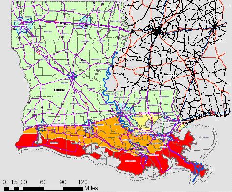
10 Phase I 100,000 Residents Phase II 500,000 Residents Phase III 1,000,000 Residents


11
12 Load Contraflow side (I-10 East) at 4 locations in Metairie and Kenner Normal flow side (I-10 West) will be directed to I-55 North Contraflow side will be crossed back to I-10 West side in LaPlace towards Baton Rouge
13 Causeway Bridge traffic will pass through Mandeville s 2 controlled traffic lights and continue north onto US 190 West (north) At I-12, Causeway traffic will be diverted to I- 12 West via a two lane ramp. This traffic will continue west to Hammond (I-55 Contraflow) and then north on I-55 I-12 West will be closed at Covington and directed to US 190 West (north)
14 I-55 North will be crossed to Contraflow side through a crossover at I-12 I-12 West will be directed to I-55 North I-55 Contraflow will continue into Mississippi to US 84 (Brookhaven) where Contraflow side will be diverted to US 84 West towards Natchez
15 3 lanes of I-10 East from New Orleans East will continue onto Eastbound Twin Span Bridge as 3 lanes by using the right shoulder as a travel lane Eastbound Twin Span Bridge will be heavily patrolled for crashes and breakdowns by Police and MAP units. Contract Wreckers will be stationed along the evacuation routes
16 2 lanes of I-10 East will be crossed to Contraflow side (I-59 South) through a crossover at the I-10/12/59 Interchange Right lane of I-10 East will continue onto I-59 North, I-10 West will be diverted to I-59 North No traffic will be allowed onto I-12 West from I-10
17 Plan- Have an evacuation plan to include alternate destinations. Two-thirds of the lanes out of Metro New Orleans go North. Leave Early- If you leave early there are no route restrictions. If you wait until Phase III begins you risk being directed away from your intended destination. Reliable Transportation- Check your vehicle (full fuel, spare tire, ) and take only the vehicle you need to evacuate in. Don t take more vehicles than you need.
18 1. Developed to improve on traffic congestion from Rita evacuation 2. Involves Lake Charles & Lafayette Regions 3. Applied lessons learned from New Orleans Contraflow Plan Maximize efficient use of northern routes Accommodate evacuation needs in susceptible areas first Eliminate, reduce or better manage congestion bottlenecks
19 Phase Condition Decision Staging (72 hours) Storm enters Gulf (Slow moving Category 3 or Higher) Stage field assets at Districts Place personnel on stand-by 1 (50 hours) Evacuation south of Intracoastal 2 (40 hours) Evacuation south of I-10 Prepare for Contraflow Stage field assets at roadside Mandatory evacuation for Lake Charles (includes urban area) Implement Lake Charles Contraflow Plan 3 (30 hours) Traffic conditions warrant, or Mass mandatory evacuation ordered Implement Lafayette Contraflow Plan
20 1. Significant traffic congestion resulted in SW LA from Rita evacuation 2. Evacuation plan needed to be improved 3. Benefits of Improved Plan maximizes use of northern routes accommodates evacuees from more susceptible areas addresses traffic needs from other states reduces traffic congestion on I-10
21 1. Restrict Interstate access to US 171 & US 165 NB, give priority to local evacuation needs 2. Upgrade signalization on US 171 & US 165 to better manage traffic in pass-through areas 3. Contraflow I-10 to provide more efficient access to US 165 NB 4. Contraflow I-49 to improve traffic flow at I-10/I-49 interchange


22 1. Operated for 25 hours 2. Over 1 million (est.) evacuated 3. Longest delay: 2 3 hours 4. Activated the Traffic Control Center 5. Achieved efficient use of Interstate & alternate routes 6. Educated & continuously informed public 7. Cited as a success by numerous entities in after action reviews
23 New crossovers constructed Portable variable message signs acquired Permanent message boards installed TCC completed and tested Maps developed and distributed Public education has begun and is on-going Plan has been exercised by all agencies at all levels


24
EMERGENCY PREPAREDNESS PARTNERSHIP LOUISIANA CONTRAFLOW OPERATIONS BRIEFING
 EMERGENCY PREPAREDNESS PARTNERSHIP LOUISIANA CONTRAFLOW OPERATIONS BRIEFING NEW CONTRAFLOW PLAN SITUATION 2 million people at risk in Southeast Louisiana 1.2 million in New Orleans Metro area alone Very
Offset Single Point Interchange I-25 at Rio Bravo Boulevard Albuquerque, New Mexico
 Offset Single Point Interchange I-25 at Rio Bravo Boulevard Albuquerque, New Mexico INSTITUTE OF TRANSPORTATION ENGINEERS 2016 WESTERN DISTRICT MEETING JULY 11, 2016 7/11/2016 1 Project Vicinity Map 7/11/2016
CONTRAFLOW PLAN FOR INTERSTATE HURRICANE EVACUATION TRAFFIC CONTROL
 CONTRAFLOW PLAN FOR INTERSTATE HURRICANE EVACUATION TRAFFIC CONTROL JUNE 2006 The document is maintained by the Emergency Services Manager, Mississippi Department of Transportation, P.O. Box 1850 Jackson,
Corridor Studies. LA 415 and LA 73
 Corridor Studies LA 415 and LA 73 Project Approach for Both Corridors 1. Data Collection 2. Data Summary 3. Traffic Analysis 4. Micro-Simulation modeling 5. Generation of alternatives 6. Modeling alternatives
Legislative Update Williamsburg Residency
 Hampton Roads District Legislative Update Williamsburg Residency Jim Brewer, Resident Administrator 757-253-5140 Projects Under Way Warwick Boulevard Project http://www.warwickboulevard.org/ Contractors:
Traffic Analysis Report No-Build Conditions (2040)
") Traffic Analysis Report No-Build Conditions (2040) LA 23 New Orleans Gulf Coast Railway Relocation PE/NEPA Project Jefferson and Plaquemines Parishes, Louisiana RPC Task LA23RR1 RPC/FRA Grant # FR-RLD-0032-14-01-00
Traffic Analysis Report No-Build Conditions (2040) LA 23 New Orleans Gulf Coast Railway Relocation PE/NEPA Project Jefferson and Plaquemines Parishes, Louisiana RPC Task LA23RR1 RPC/FRA Grant # FR-RLD-0032-14-01-00
INNOVATIVE INTERSECTION DESIGN
 INNOVATIVE INTERSECTION DESIGN J. Eddie Valtier, P.E. ELP TP&D Director Introduction Why Do We Need To Start Looking For Innovative Intersection Designs? Congestion is worsening and traffic volumes and
Comments EXECUTIVE SUMMARY
 Comments 1. Under any Alternatives, MCDOT should provide better at-grade pedestrian crossing of Georgia Avenue and Forest Glen Road, including improved crosswalks with wider medians and adequate signal
Northern Virginia Express Lanes Design Challenges and Solutions. IBTTA Maintenance and Roadway Operations Workshop June 25, 2018
 Northern Virginia Express Lanes Design Challenges and Solutions IBTTA Maintenance and Roadway Operations Workshop June 25, 2018 Virginia Express Lanes Overview 60 miles of managed lanes (4 projects) Long
Holland Tunnel Exit in NJ
 Holland Tunnel Exit in NJ Using Operational Changes to Enhance Tunnel Throughput IBTTA Maintenance & Operations Workshop Daniel Jacobs, General Manager Trans. & Revenue May 17, 2016 Holland Tunnel Opened
TECHNICAL REPORT STANDARD PAGE
 TECHNICAL REPORT STANDARD PAGE 1. Report No. FHWA/LA.10/400 2. Government Accession No. 3. Recipient's Catalog No. 4. Title and Subtitle Modeling Hurricane Evacuation Traffic - Evaluation of Freeway Contraflow
Pinellas County Traffic Advisory
 12/22/17 2:00PM For up-to-date information regarding traffic (crashes) on Pinellas County roadways that are monitored by our Intelligent Transportation System (ITS) Smart Tracs cameras - follow us on Twitter
What are Managed Lanes?
 Express Lanes What are Managed Lanes? Highway facilities or a set of lanes where operational strategies are proactively implemented and managed in response to changing conditions. http://ops.fhwa.dot.gov/freewaymgmt/managedlanesvideo/index.htm
JONESBORO HIGHWAY 63 HIGHWAY 18 CONNECTOR STUDY
 JONESBORO HIGHWAY 63 HIGHWAY 18 CONNECTOR STUDY Craighead County May 2007 JONESBORO HIGHWAY 63 HIGHWAY 18 CONNECTOR STUDY Craighead County May 2007 Prepared by Planning and Research Division Arkansas State
APPENDIX G: INTERSECTION NEEDS AT OKEECHOBEE BOULEVARD
 APPENDIX G: INTERSECTION NEEDS AT OKEECHOBEE BOULEVARD INTERSECTION NEEDS AT SR 7 and OKEECHOBEE BOULEVARD SR 7 Extension Project Development and Environment (PD&E) Study From Okeechobee Boulevard (SR
Shenango Valley MPO. State Transportation Commission 2015 Twelve Year Program Development
 State Transportation Commission 2015 Twelve Year Program Development Regional results of the survey and public feedback from August thru November 2013 Shenango Valley MPO Version 01-2014 Mobility Concerns
Congestion Reducing Activities. Toby Carr GDOT Director of Planning April 10, 2014
 Congestion Reducing Activities Toby Carr GDOT Director of Planning April 10, 2014 GDOT Performance Dashboard Congestion Congestion Relief Strategies 511 HEROS RTOP Highway Emergency Response Operators
Presentation to Media. February 27, 2008
 Anacostia Waterfront Nationals Ballpark Transportation Management Plan Presentation to Media February 27, 2008 Overarching Goals of DDOT s Ballpark TMP Organize and manage traffic to ensure pedestrian
US 69 RELIEF ROUTE STUDY
 US 69 RELIEF ROUTE STUDY Jacksonville, Texas PUBLIC MEETING #2 May 29 th, 2018 Welcome to the public meeting for the US 69 Relief Route Study in Jacksonville. This is the second public meeting for this
Welcome! San Jose Avenue Open House August 25, 2015
 Welcome! San Jose Avenue Open House August 25, 2015 Vision Zero The City and County of San Francisco adopted Vision Zero San Francisco Vision Zero High Injury Network as a policy in 2014, committing an
A COMPREHENSIVE APPROACH TO TRANSPORTATION AT SUNTRUST PARK AND THE BATTERY ATLANTA
 A COMPREHENSIVE APPROACH TO TRANSPORTATION AT SUNTRUST PARK AND THE BATTERY ATLANTA Overview The Atlanta Braves strategically selected the location for SunTrust Park to provide an environment rich in transportation
Louis Haywood GNO DPW
 NEW ORLEANS REGIONAL TRAFFIC SAFETY COALITION J e f f e r s o n O r l e a n s P l a q u e m i n e s S t. B e r n a r d September 1, 2016 10:30 am-1:00pm Regional Transportation Management Center Agenda
Route 7 (East Market Street) Interchange at Battlefield Parkway Town of Leesburg Project No: UPC Presentation to Town Council
 Interchange at Battlefield Parkway Town of Leesburg Project No: UPC Presentation to Town Council") Route 7 (East Market Street) Interchange at Battlefield Parkway Town of Leesburg Project No: 0007-253-109 UPC 106573 Presentation to Town Council June 26, 2017 Council Decisions East Market Street / Battlefield
Route 7 (East Market Street) Interchange at Battlefield Parkway Town of Leesburg Project No: 0007-253-109 UPC 106573 Presentation to Town Council June 26, 2017 Council Decisions East Market Street / Battlefield
Access Routes from US 101 to the Richmond San Rafael Bridge
 Access Routes from US 101 to the Richmond San Rafael Bridge TAM Board Meeting January 28, 2016 RSRB Project Elements Eastbound Third Lane: Sir Francis Drake Blvd. to Marine Street 10 ft Barrier Separated
Description: Widen I-64 to 6 lanes from I-265 to the KY 53 interchange in Shelby County.
 I-64 KIPDA ID # 350 Project Type: ROADWAY CAPACITY Description: Widen I-64 to 6 lanes from I-265 to the KY 53 interchange in Shelby County. Purpose: Project will improve capacity and address safety concerns.
Active Traffic Management and Part-Time Shoulder Use in Montgomery County, PA
 Active Traffic Management and Part-Time Shoulder Use in Montgomery County, PA PENN STATE TESC SESSION 8B MOVING PENNDOT AND PTC FORWARD DECEMBER 8, 2017 Agenda Define Active Traffic Management and describe
JCE 4600 Transportation Engineering. Traffic Control
 JCE 4600 Transportation Engineering Traffic Control Human Factors Primary Driving Tasks NAVIGATION GUIDANCE CONTROL What makes a Traffic Control Device Effective? Fulfill a need Command Attention Convey
MOBILITY RESULTS AREA. Budgeting For Outcomes Council Presentation January 12, 2007
 MOBILITY RESULTS AREA Budgeting For Outcomes Council Presentation January 12, 2007 Mobility Results Team Members 2 Hammond Perot, OED, Co-Team Leader Bonnie Meeder, DEV (returning), Co-Team Leader Peer
JANUARY Danger Zones: A summary of pedestrian fatality trends in Louisiana
 JANUARY 2014 Danger Zones: A summary of pedestrian fatality trends in Louisiana TEN YEARS OF DANGER: Pedestrian Deaths in Louisiana Although vehicular deaths have decreased in Louisiana, pedestrian deaths
I would like to welcome Parish President VJ St. Pierre, Councilwoman Carolyn Schexnaydre and Councilman Terry Authement who are here.
 IER 1, 2 and 3 Public Meeting Thursday, December 6, 2007 Location Time Attendees Format Handouts Facilitator Ramada New Orleans Airport 110 James Drive East St. Rose, LA 70087 6:00 p.m. Open House 7:00
Attached for your reference please find project updates on ongoing VDOT construction projects in Southampton County.
 SOUTHAMPTON COUNTY BOARD OF SUPERVISORS Regular Session i July 25, 2016 6. HIGHWAY MATTERS A. PLAN PROJECT UPDATES Attached for your reference please find project updates on ongoing VDOT construction projects
Optimizing The Operations of Closely Spaced Traffic Signals. Gordon E. Meth, P.E., PTOE ITE District 1 Annual Meeting May 21, 2004
 Optimizing The Operations of Closely Spaced Traffic Signals Gordon E. Meth, P.E., PTOE ITE District 1 Annual Meeting May 21, 2004 Closely Spaced Signals - The Challenges According to many sources, minimum
Idaho Driver Education and Training
 Idaho Driver Education and Training Strategies for Controlled Access Highways Part I M13-1 Introduction to Controlled Access Highways Plans for the Interstate System," began in the late 1930s The system
I-20 ODESSA-MIDLAND CORRIDOR STUDY. Public Meeting for Schematic Design
 I-20 ODESSA-MIDLAND CORRIDOR STUDY Public Meeting for Schematic Design The environmental review, consultation, and other actions required by applicable Federal environmental laws for this project are being,
MoPac South: Impact on Cesar Chavez Street and the Downtown Network
 MoPac South: Impact on Cesar Chavez Street and the Downtown Network Prepared by: The University of Texas at Austin Center for Transportation Research Prepared for: Central Texas Regional Mobility Authority
FACT SHEET VirginiaDOT.org
 FACT SHEET VirginiaDOT.org Interstate 64 East Hampton Roads Bridge-Tunnel (HRBT) Paving Project Hampton/ Norfolk Contractor: Basic Construction (part of the I-64 paving project in Hampton) Contract Amount:
TECHNICAL REPORT STANDARD PAGE
 TECHNICAL REPORT STANDARD PAGE 1. Report No. FHWA/LA.06/400 2. Government Accession No. 3. Recipient's Catalog No. 4. Title and Subtitle Modeling Hurricane Evacuation Traffic: Evaluation of Freeway Contraflow
TRANSPORTATION FACILITY PLANNING Waugh Chapel Road Maytime Drive to New Market Lane
 July 24, 2018 TRANSPORTATION FACILITY PLANNING Waugh Chapel Road Maytime Drive to New Market Lane DPWandYOU.com Making a difference, together Meeting Agenda Purpose of the project Overview of work conducted
FM #: ETDM #: 11241
 SR 826/Palmetto Expressway PD&E Study From SR 93/I 75 to the Golden Glades Interchange FM #: 418423 1 22 01 ETDM #: 11241 Agency/ Kick Off Meeting October 27, 2011 2 Location Map From SR 93/I 75 to Golden
I-395 Express Lanes Northern Extension Project Crystal City Civic Association September 21, 2016
 I-395 Express Lanes Northern Extension Project Crystal City Civic Association September 21, 2016 Mike Snare, PE, Project Manager Virginia Department of Transportation GEC Michelle Holland, Megaprojects
Route 29 Solutions Projects
 Route 29 Solutions Route 29 Solutions Projects www.route29solutions.org October 10, 2014 Route 29 Widening to Six Lanes Albemarle County This project will widen a 1.8-mile segment of Route 29 from four
I-35W Solutions Alliance Project Update July 13, 2017
 Title I-35W Solutions Alliance Project Update July 13, 2017 Evaluating the potential for Bus Rapid Transit and MnPASS Express Lanes in the southwest Metro, Investigating options for improved bus service
Bluffdale/ UDOT South High-T Intersection Project Type Operations
 Bluffdale/ UDOT 14600 South High-T Intersection Project Type Operations 14600 South and Redwood Road $ 600,000 $ 550,000 This project is to install a new High-T intersection at Redwood Road and 14600 South
I-264 CORRIDOR EVALUATION STUDY. September 7, 2016 Eric Stringfield VDOT Planning Director Chris Lawrence AECOM Senior Transportation Engineer
 I-264 CORRIDOR EVALUATION STUDY September 7, 2016 Eric Stringfield VDOT Planning Director Chris Lawrence AECOM Senior Transportation Engineer Study Overview Interchange Locations Study Context Follow-up
Base Information. 1. Project Title Erie Parkway and WCR 7 Traffic Signal Project
 Part 1 Base Information 1. Project Title Erie Parkway and WCR 7 Traffic Signal Project 2. Project Start/End points or Geographic Area Provide a map with submittal, as appropriate 3. Project Sponsor (entity
Innovative Intersections Presented by: Matt Crim P.E., PTOE Stantec Consulting Services Inc. October 29, 2015
 Innovative Intersections Presented by: Matt Crim P.E., PTOE Stantec Consulting Services Inc. October 29, 2015 1 Traditional Intersections Traditional Intersections allow left turns from all approaches.
Highway 49, Highway 351 and Highway 91 Improvements Feasibility Study Craighead County
 Highway 49, Highway 351 and Highway 91 Improvements Feasibility Study Craighead County Executive Summary March 2015 Highway 49, Highway 351 and Highway 91 Improvements Feasibility Study Craighead County
June 29, Dear Mr. Walter:
 From: CountyBoard@arlingtonva.us To: chickandsandy@msn.com Subject: County Board Response Regarding the Arlington Ridge Road Improvement Project (Intranet Quorum IMA00252707) Date: Wed, 29 Jun 2011 08:09:53-0400
#!! "$% ##! &! # '#! % $ #!
 Executive Summary US Highway 16 (US 16) is the primary corridor connecting Rapid City to the Black Hills region. It serves a growing population of commercial and residential traffic, as well as seasonal
UPC Design / CN Locally Administered PE Phase VDOT Administered CN Phase
 Presentation for County Board, February 27, 2018 Regular Hearing N. Lynn Street Esplanade and Custis Trail Improvements Funding Request for VDOT Construction Bid Award UPC Design 70762 / CN 109813 Locally
Chapter 4 Traffic Analysis
 Chapter 4 Traffic Analysis PURPOSE The traffic analysis component of the K-68 Corridor Management Plan incorporates information on the existing transportation network, such as traffic volumes and intersection
Freeway System Considerations
 Session 11 Jack Broz, PE, HR Green May 5-7, 2010 Freeway System Considerations Mainline Transit: Shoulder Operations, BRT, Stations HOV, HOT, UPA Interchanges Exit Ramps Entrance Ramps Bridges Local Crossings
Houma-Thibodaux Metropolitan Planning Organization STP<200K Funding Application APPLICATION
 APPLICATION HOUMA-THIBODAUX METROPOLITAN PLANNING ORGANIZATION (HTMPO) FOR SURFACE TRANSPORTATION PROGRAM (STP
Appendix 12 Consequences
 Appendix 12 Consequences Overview All of the consequence data used in the risk analysis was provided by the IPET Consequence team whose work is reported in Volume VII of the IPET report. The following
PRELIMINARY DRAFT WADDLE ROAD / I-99 INTERCHANGE PROJECT ALTERNATIVE ANALYSIS FINAL TRAFFIC SUMMARY REPORT
 PRELIMINARY DRAFT WADDLE ROAD / I-99 INTERCHANGE PROJECT ALTERNATIVE ANALYSIS FINAL TRAFFIC SUMMARY REPORT Prepared by: In Association with: November 2013 EXECUTIVE SUMMARY Patton Township, in partnership
Traffic Incident Management. Business Case Study. Co-location of Arizona Department of Public Safety and Department of Transportation
 Traffic Incident Management Business Case Study Co-location of Arizona Department of Public Safety and Department of Transportation Kimberly Campbell Emergency Manager 1 What is Traffic Incident Management?
I-395 Express Lanes Northern Extension Project Fairlington Citizens Association September 12, 2016
 I-395 Express Lanes Northern Extension Project Fairlington Citizens Association September 12, 2016 Susan Shaw, PE, Megaprojects Director, Virginia Department of Transportation Amanda Baxter, Special Projects
Kingwood Area Mobility Study. Lake Houston Redevelopment Authority (TIRZ #10)
") Kingwood Area Mobility Study Lake Houston Redevelopment Authority (TIRZ #10) Steering Committee Meeting #3 Date: May 27, 2014 Introductions/Remarks Steering Committee Project/Consultant Team GOALS & MOE
Kingwood Area Mobility Study Lake Houston Redevelopment Authority (TIRZ #10) Steering Committee Meeting #3 Date: May 27, 2014 Introductions/Remarks Steering Committee Project/Consultant Team GOALS & MOE
New Orleans Complete Streets Experience CITY OF NEW ORLEANS. Louis Haywood Department of Public Works January 19, 2016
 New Orleans Complete Streets Experience CITY OF NEW ORLEANS Louis Haywood Department of Public Works January 19, 2016 Complete Streets policies Ensure that the entire right-of-way is planned, designed,
4404 St. Peter Street New Orleans, LA (504) April 13 th, To Whom It May Concern:
 April 13 th, To Whom It May Concern:") 4404 St. Peter Street New Orleans, LA 70119 (504) 861-4022 info@bikeeasy.org April 13 th, 2014 To Whom It May Concern: We are writing to present a design solution for Lakeshore Drive. Earlier this month,
4404 St. Peter Street New Orleans, LA 70119 (504) 861-4022 info@bikeeasy.org April 13 th, 2014 To Whom It May Concern: We are writing to present a design solution for Lakeshore Drive. Earlier this month,
Access Management Regulations and Standards
 Access Management Regulations and Standards Efficient highway operation Reasonable property access Concept of Access Management The way to manage access to land development while simultaneously preserving
Improving Mobility Without Building More Lanes
 Improving Mobility Without Building More Lanes By Mike Salisbury and Will Toor July 2017 Copyright 2017 by Southwest Energy Efficiency Project. All rights reserved. Photo: Courtesy of the Denver Post Anyone
Proposed. City of Grand Junction Complete Streets Policy. Exhibit 10
 Proposed City of Grand Junction Complete Streets Policy Exhibit 10 1 City of Grand Junction Complete Streets Policy Vision: The Complete Streets Vision is to develop a safe, efficient, and reliable travel
Interstate Route 77 / US Route 62 / State Route 687 (Fulton Road) Transportation Improvement Project. Prepared September 6, 2017
 Transportation Improvement Project. Prepared September 6, 2017") EODOT Project: ODOT Project: STA-IR 77-.50; PID 00290 Interstate Route 77 / US Route 62 / State Route 687 (Fulton Road) Transportation Improvement Project Summary of Public Comments Received and Responses
EODOT Project: ODOT Project: STA-IR 77-.50; PID 00290 Interstate Route 77 / US Route 62 / State Route 687 (Fulton Road) Transportation Improvement Project Summary of Public Comments Received and Responses
Chapter 5 Future Transportation
 Chapter 5 Future Transportation The Future Land Use Plan identifies the desired land use designations. The land uses desired for Crozet depend, in large part, on the success of the transportation system,
Road Diets. Presented by: Cristine Gowland, P.E. LADOTD District 62 March 2, 2016
 Road Diets Presented by: Cristine Gowland, P.E. LADOTD District 62 March 2, 2016 FHWA s 9 Proven Safety Countermeasures 1. Safety Edge 2. Roundabouts 3. Corridor Access Management 4. Backplates with Retroreflective
Multi Modal Transit Access Plan KIPDA ID # 239. Project Type: STUDY
 Multi Modal Transit Access Plan KIPDA ID # 239 Project Type: STUDY Description: In conjunction with the results from Project Gobility and the Transit LOS Analysis, TARC seeks to examine the possibilities
Gwinnett County Department of Transportation SR 324 / Gravel Springs Road at I-85 / SR 403 Interchange Project Number F , PI No.
 June 4, 2015 Dear Resident: Thank you for attending this public information meeting for the proposed SR 324 / Gravel Springs Road at I-85 Interchange. The purpose of this meeting is two-fold: to provide
West Dimond Blvd Upgrade Jodhpur Street to Sand Lake Road
 West Dimond Blvd Jodhpur St to Sand Lake CSS Transportation Project Summary Municipality of Anchorage Project # 05 005 Project Manager: John Smith, P.E. (MOA PM&E) Project Administrator: Julie Makela,
City of Wayzata Comprehensive Plan 2030 Transportation Chapter: Appendix A
 A1. Functional Classification Table A-1 illustrates the Metropolitan Council s detailed criteria established for the functional classification of roadways within the Twin Cities Metropolitan Area. Table
Characteristics of. Entering & Exiting High Speed Considerations
 Mod 6 Characteristics of Expressways Entering & Exiting High Speed Considerations Characteristics of an Expressway Controlled access (limited entry and exit) High speed (up to 65 mph) Divided by a barrier
Managed Lanes. Steve Schilke, P.E. Major Projects Unit Head District 1. Illinois Traffic Engineering and Safety Conference October 2016
 Managed Lanes Steve Schilke, P.E. Major Projects Unit Head District 1 Illinois Traffic Engineering and Safety Conference October 2016 Agenda Managed Lanes Projects I-55 (Stevenson Expressway) Express Toll
WHITE PAPER: TRANSIT SERVICE FOR SOUTH SHAGANAPPI
 9/27/2012 TRANSIT PLANNING WHITE PAPER: TRANSIT SERVICE FOR SOUTH SHAGANAPPI 2012 Calgary Transit 1 Table of Contents Purpose... 3 Area of Change... 3 Background... 3 Access to destinations... 5 Connecting
CONTRAFLOW EVACUATION ON THE WESTBOUND I-10 OUT OF THE CITY OF NEW ORLEANS. A Thesis
 CONTRAFLOW EVACUATION ON THE WESTBOUND I-10 OUT OF THE CITY OF NEW ORLEANS A Thesis Submitted to the Graduate Faculty of the Louisiana State University and Agricultural and Mechanical College in partial
2. Context. Existing framework. The context. The challenge. Transport Strategy
 Transport Strategy Providing quality connections Contents 1. Introduction 2. Context 3. Long-term direction 4. Three-year priorities 5. Strategy tree Wellington City Council July 2006 1. Introduction Wellington
Appendix T 1: Additional Supporting Data
 Appendix T 1: Additional Supporting Data Project Delivery Delays with the implementation of the 2000 TIP became apparent early in the decade. In response to direction among policy officials, ARC began
Department of Transportation
 Department of Transportation I. Internal Scan The number of older drivers in the United States will double over the next 30 years. By 2030 one in five Americans will be age 65 or older. On a licensed-driver
I-95/Temple Avenue Improvements Project Colonial Heights, VA
 I-95/Temple Avenue Improvements Project Colonial Heights, VA Pardon Our Dust Informational Meeting February 3, 2016 Harold Dyson, P.E. Construction Manager, Richmond District Tom Heil, P.E. Allan Myers
Click to edit Master title style
 Route N Study Community Advisory Group (CAG) Meeting #2 December 12, 2018 Click Agenda to edit Master title style Introductions Recap of the CAG Meeting #1 and Public Meeting #1 Purpose & Need Review Review
Project Description Form 6V
 Project Description Form 6V Basic Project Information Submitting Jurisdiction/Agency: Prince William County Project Title: Route 15 Widening: Route 55 to south of RR tracks & Construct RR Overpass Project
M-58 HIGHWAY ACCESS MANAGEMENT STUDY Mullen Road to Bel-Ray Boulevard. Prepared for CITY OF BELTON. May 2016
 M-58 HIGHWAY ACCESS MANAGEMENT STUDY Prepared for CITY OF BELTON By May 2016 Introduction Missouri State Highway 58 (M-58 Highway) is a major commercial corridor in the City of Belton. As development has
Parks Highway: MP Lucus Road to Big Lake Road
 2 Purpose and Need 2.1 Corridor History The Parks Highway is a 324-mile long Rural Interstate Highway that extends from its intersection with the Glenn Highway north to Fairbanks, Alaska. The Parks Highway
Table of Contents. Guidelines on Rolling Roadblocks for Work Zone Applications
 431919.ATSSA_431919.ATSSA 8/16/13 6:16 AM Page 1 431919.ATSSA_431919.ATSSA 8/16/13 6:16 AM Page 1 Table of Contents What Is a Rolling Roadblock?...3 Where Rolling Roadblocks are Used...4 Planning and Coordinating
Highway 169 Mobility Study Technical Advisory Committee Meeting #9 Meeting Record
 Highway 169 Mobility Study Technical Advisory Committee Meeting #9 Meeting Record Thursday, May 25, 2017 8:30-10:30 a.m. City of Eden Prairie Heritage Rooms I and II Attendees Brad Larsen, MnDOT Angie
Traffic Control Inspection Checklist Segment:
 Traffic Control Inspection Checklist Segment: Simon Contractors Simon Contractors Originator: Description Reviewed by: Initials Date Distribution: Traffic Quality Manager, Site Assistant Traffic Manager
405 Express Lanes General Information & Frequently Asked Questions
 The questions and answers below provide current information on the project to improve Interstate 405 (I-405) in Orange County from State Route 73 to Interstate 605. Why are improvements needed on I-405?
Work Session. Agenda Item # 4. Meeting Date September 8, Daryl Braithwaite Public Works Director. Prepared By. Suzanne R. Ludlow City Manager
 Agenda Item # 4 Work Session Meeting Date September 8, 2015 Prepared By Approved By Daryl Braithwaite Public Works Director Suzanne R. Ludlow City Manager Discussion Item Background Temporary Neighborhood
Highway 17 Transportation Improvement Study
 Final Report Highway 17 Transportation Improvement Study prepared for Santa Cruz County Regional Transportation Commission (SCCRTC) prepared by Planning and Engineering, Inc. 1155 North First Street, Suite
BOSTON REGION METROPOLITAN PLANNING ORGANIZATION MEMORANDUM. DATE June 2, 2011
 BOSTON METROPOLITAN PLANNING ORGANIZATION State Transportation Building Ten Park Plaza, Suite 2150 Boston, MA 02116-3968 Tel. (617) 973-7100 Fax (617) 973-8855 TTY (617) 973-7089 www.bostonmpo.org Jeffrey
AGENDA REPORT. Issue: Discussion of potential improvements on Barnwell Road at Niblick Drive
 AGENDA REPORT To: From: By: Honorable Mayor and City Council Members Warren Hutmacher, City Manager Tom Black, Public Works Director Date: March 23, 2016 Agenda: March 28, 2016 WORK SESSION AGENDA: Barnwell
PERFORMANCE ACTIVITY 613 IMPACT ATTENUATOR WORK DESCRIPTION 3
 PERFORMANCE ACTIVITY 613 IMPACT ATTENUATOR WORK DESCRIPTION 1 WORK DESCRIPTION 2 WORK DESCRIPTION 3 Install Remove Repair 613 IMPACT ATTENUATOR ACTIVITY DESCRIPTION Repair, install, remove and maintain
Kentucky s Surface Transportation System
 Kentucky s Surface Transportation System ROAD AND BRIDGE CONDITIONS, TRAFFIC SAFETY, TRAVEL TRENDS, AND NEEDS MARCH 2018 PREPARED BY WWW.TRIPNET.ORG Founded in 1971, TRIP of Washington, DC, is a nonprofit
Southside Road. Prepared for: City of St. John s Police & Traffic Committee. Prepared by: City of St. John s Traffic Division
 Southside Road Prepared for: City of St. John s Police & Traffic Committee Prepared by: City of St. John s Traffic Division January 2007 Southside Road - Traffic Report Page 1 of 9 BACKGROUND: th At the
Using moveable barrier in the new urban environment
 23 rd ITS World Congress, Melbourne, Australia, 10 14 October 2016 Paper number ITS-AM-TP0167 Using moveable barrier in the new urban environment Paul Grant 1* 1. Lindsay Transportation Solutions, 180
MOUNTAIN HOUSE SPECIFIC PLAN I 9.1 INTRODUCTION ASSUMPTIONS TRANSPORTATION FACILITIES TRANSPORTATION IMPROVEMENTS PHASING 9.
 CHAPTER NINE: TRANSPORTATION AND CIRCULATION 9.1 INTRODUCTION 9.1 9.2 ASSUMPTIONS 9.1 9.3 TRANSPORTATION FACILITIES 9.1 9.4 TRANSPORTATION IMPROVEMENTS PHASING 9.3 LIST OF FIGURES LIST OF TABLES Figure
WELCOME. FM 2818 (Harvey Mitchell Parkway) Open House. Tuesday, Nov. 14, 2017
 Open House. Tuesday, Nov. 14, 2017") WELCOME FM 2818 (Harvey Mitchell Parkway) Open House Tuesday, Nov. 14, 2017 Why am I here? Review the planned improvements Provide comments on the proposed project The environmental review, consultation,
WELCOME FM 2818 (Harvey Mitchell Parkway) Open House Tuesday, Nov. 14, 2017 Why am I here? Review the planned improvements Provide comments on the proposed project The environmental review, consultation,
I-395 Express Lanes Northern Extension Project Public Hearings
 I-395 Express Lanes Northern Extension Project Public Hearings Susan Shaw, PE, Megaprojects Director Virginia Department of Transportation Amanda Baxter, Special Projects Manager Virginia Department of
Financial Project ID No(s).: and ETDM No(s).: and 14181
.: and ETDM No(s).: and 14181") Palm Beach Metropolitan Planning Organization (MPO) Presentation I-95 at Boynton Beach Boulevard Interchange and I-95 at Gateway Boulevard Interchange Project Development and Environment Study Palm Beach
Palm Beach Metropolitan Planning Organization (MPO) Presentation I-95 at Boynton Beach Boulevard Interchange and I-95 at Gateway Boulevard Interchange Project Development and Environment Study Palm Beach
Owl Canyon Corridor Project Overview and Summary
 Owl Canyon Corridor Project Overview and Summary December 22, 2008 The Owl Canyon corridor (generally the connection between the I-25 / Larimer County Road 70 interchange and the US 287 / Larimer County
I-215 / NEWPORT ROAD INTERCHANGE PROJECT PRESS KIT
 I-215 / NEWPORT ROAD INTERCHANGE PROJECT PRESS KIT March I-215 / NEWPORT ROAD INTERCHANGE PROJECT Fact Sheet Project Overview This project will reconstruct the existing interchange located on Interstate