Town of Duck, North Carolina
|
|
|
- June Hunt
- 5 years ago
- Views:
Transcription

1 Tracking No Erosion Mitigation And Shoreline Management Feasibility Study Town of Duck, North Carolina Coastal Planning & Engineering of North Carolina August 15, 2012 Tom Jarrett Robert Neal Ken Willson 1
2 Tracking No Outline: Review Goals of Study Phase 1 Coastal Process/Erosion Impacts Phase 2 Concepts/Cost/Timeline Results of Phase 1 Shoreline Change Rates Trends/Reversals Pier Impacts Erosion Economics Phase 2 Concepts 2
3 Tracking No Goals of the Study Evaluate shoreline changes along entire town Investigate the cause, extent, and severity of the chronic erosion area or Hot Spot just north of the Research Pier Develop an erosion mitigation strategy to address this Hot Spot Develop a long term shoreline management strategy for the entire Town
4 Tracking No OUR APPROACH Develop Comprehensive Understanding of Coastal Processes Project Shoreline Change Rates (5, 10, 15, 30, and 50 Years) Develop Short-Term and Long-Term Management Alternatives to Address Erosion Determine Permitting Costs Potential Sand Sources Construction Costs 4
5 Tracking No OUR APPROACH Develop Comprehensive Understanding of Coastal Processes PHASE 1 Project Shoreline Change Rates (5, 10, 15, 30, and 50 Years) Develop Short-Term and Long-Term Management Alternatives to Address Erosion Determine Permitting Costs Potential Sand Sources Construction Costs PHASE 2

6 Tracking No Phase 1: Coastal Process and 1. Shoreline Change Rates Shoreline Impact Analysis What are the Shoreline Change Rates? 2. Trends or Reversals Should we expect past shoreline trends to remain constant or could they reverse? 3. Pier Impacts Is the Pier impacting shoreline change rates? 4. Economic Losses Due to Shoreline Change Rates How much public and private property is threatened (Short-Term and Long-Term)?

7 Tracking No Phase 1: Coastal Process and Shoreline Impact Analysis 1: Shoreline Change Rates 11 LiDAR data sets between 1996 and Analysis extends from 1 mile south of Town through 1 mile north of Town. 543 Transects established (100 ft. Spacing) Transects grouped into 10 segments with similar trends between Analysis extended back to 1940 using USGS data
8 8 Example of Shoreline Transects
9 Cumulative Change (ft) 9 40 Cumulative Shoreline Change since 1996-South of the FRF Pier Jun-96 Jun-98 Jun-00 Jun-02 Jun-04 Jun-06 Jun-08 Jun-10 Date of LiDAR survey Seg 1 ( to ) Seg 2 ( to -8000) Seg 3 (-8000 to -6000) Seg 4 (-6000 to -2000) Seg 5 (-2000 to 0)
10 Cumulative Change (ft) Cumulative Shoreline Change since 1996-North of the FRF Pier Jun-96 Jun-98 Jun-00 Jun-02 Jun-04 Jun-06 Jun-08 Jun-10 Date of LiDAR survey Seg 6 (0 to 1000) Seg 7 (1000 to 6000) Seg 8 (6000 to 14000) Seg 9 (14000 to 16000) Seg 10 (16000 to 30000)
11 Cumulative Change (ft) Cumulative Shoreline Change South of FRF Pier Since Jan-40 Jan-50 Jan-60 Jan-70 Jan-80 Jan-90 Jan-00 Jan-10 Date of survey Seg 1 Seg 2 Seg 3 Seg 4 Seg 5
12 Cumulative Shoreline Change (ft) Cumulative Shoreline Changes North of FRF Pier Since Jan-40 Jan-50 Jan-60 Jan-70 Jan-80 Jan-90 Jan-00 Jan-10 Date Seg 6 Seg 7 Seg 8 Seg 9 Seg 10
13 13 Phase 1: Coastal Process and Shoreline Impact Analysis 1: Shoreline Change Rates Shoreline Segment Average Shoreline Trend by Segment for Transect Grouping Distance From Pier (ft) 1996 to 2011 (ft/yr) Overall Trend Total Movement (ft) 1 9 to 89-22,000 to -14, to ,000 to -8, to 169-8,000 to -6, to 209-6,000 to -2, to 229-2,000 to to to 1, to 289 1,000 to 6, to 369 6,000 to 14, to ,000 to 16, to ,000 to 30,

14 14 Dune Toe

15 15 Comparison MHW Change to Toe of Dune Change
16 Tracking No Phase 1: Coastal Process and Shoreline Impact Analysis 2: Trends and Reversals Reviewed Wave Data from FRF and other gauges. Possibility of Sand Wave Migration. Influence of shore oblique sand bars
17 17

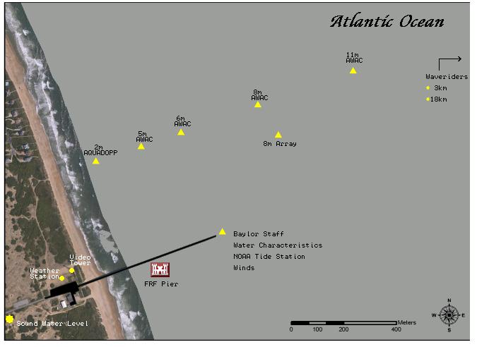
18 Meters / 57 Feet FRF Pier
 Potential Monthly Sediment Transport Rates Oct 1996 to Nov 2011 (Based on Gauge 3111) 19 350,000 250,000 150,000")
19 Tracking No Potential Monthly Alongshore Sediment Transport (CY) Potential Monthly Sediment Transport Rates Oct 1996 to Nov 2011 (Based on Gauge 3111) , , ,000 50,000-50, , , ,000 Oct-96 Oct-98 Oct-00 Oct-02 Oct-04 Oct-06 Oct-08 Oct-10 Date Transport to South Transport to North Dominate Littoral Transport to the North
20 Tracking No Phase 1: Coastal Process and Shoreline Impact Analysis 2: Trends and Reversals Net northward sediment transport No clear correlation between wave data and shoreline change based on LiDAR data sets No significant differences in average storm conditions when comparing and No major difference in storm conditions from 1980 to 1996 compared to other time period.
21 Rate (ft/yr) 21 2: Shoreline Trends and Reversals Transect 1940 to to to 2011 Southern Town Limit FRF Pier Northern Town Limit
22 Tracking No Phase 1: Coastal Process and Shoreline Impact Analysis 3: Pier Impacts Analytical method to independently evaluate cross-shore (EVEN) and alongshore (ODD) shoreline changes due to potential obstruction. Cross-shore influences (storms) should impact the shoreline about the same up-coast and down-cost of pier, hence EVEN influence. Pier could potentially influence alongshore sediment transport and cause unequal impacts up-coast and down-coast, hence ODD influence. Cross-shore plus alongshore equals total shoreline response. 22
23 Tracking No Even Odd Analysis Limit of Long- Shore Influence
24 24 Phase 1: Coastal Process and Shoreline Impact Analysis 4: Economic Losses Due To Shoreline Change Rates Mean High Water Mean Sea Level Mean Sea Level
25 25 Phase 1: Coastal Process and Shoreline Impact Analysis 4: Economic Losses Due To Shoreline Change Rates Erosion Rate of 5 ft./ Year 40 ft. Mean High Water Mean Sea Level Mean Sea Level
26 26 Phase 1: Coastal Process and Shoreline Impact Analysis 4: Economic Losses Due To Shoreline Change Rates Apply 10 Years of Erosion Erosion Rate of 5 ft./ Year Mean High Water Mean Sea Level Mean Sea Level
27 27 Phase 1: Coastal Process and Shoreline Impact Analysis 4: Economic Losses Due To Shoreline Change Rates Apply 10 Years of Erosion Erosion Rate of 5 ft./ Year 5 ft./yr. X 10 years = 50 ft. Mean High Water Mean Sea Level Mean Sea Level

28 28 Phase 1: Coastal Process and Shoreline Impact Analysis 4: Economic Losses Due To Shoreline Change Rates Apply 10 Years of Erosion Erosion Rate of 5 ft./ Year 5 ft./yr. X 10 years = 50 ft. Mean High Water Mean Sea Level Mean Sea Level
29 Tracking No Phase 1: Coastal Process and Shoreline Impact Analysis 4: Economic Losses Due To Shoreline Change Rates shoreline change rates were applied to the existing dune toe Developed predicted dune toe position for 5, 10, 15, 30, and 50-year timeframes Parcel value reduced based on percentage lost Structure considered total loss when the predicted dune toe intersected or became landward of the structure. Pools $50K deduction from structural value

30 30 Predicted Dune Toe Positions
31 31 Phase 1: Coastal Process and Shoreline Impact Analysis 4: Economic Losses Due To Shoreline Change Rates Years Cumulative Area Lost (acres) Parcels Lost (US Dollars) $72,617,984 $6,164,873 $6,168,610 $18,526,114 $17,937,543 $121,415,125 Building Affected Pools Affected Lost Infrastructure (USD) $350,000 $3,163,900 $13,168,650 $9,518,950 $1,026,600 $27,228,100 Results from Phase 1
32 Tracking No Phase 2: Alternative Analysis Now That We Have Identified The Problem: What alternatives do we have that will mitigate erosion damage to public and private property? What are the cost of implementing these alternatives? How long will it take to implement these alternatives? Considered economic value, innovative solutions, and Town-wide benefits
33 Tracking No Phase 2: Alternative Analysis Develop a cost estimate for obtaining permits for the project. Develop a schedule to obtain permits for the project Develop a cost and schedule associated with Construction of the Project: (Note: Town may want to consider continuing shoreline monitoring by FRF)
34 Tracking No Phase 2: Alternative Analysis No Action Alternative Erosion Mitigation Beach Fill Project Segmented Truck Haul Beach Fill Economic Impacts of Short Term vs. Long Term Mitigation
35 35 Erosion Mitigation Beach Fill:
36 36 Erosion Mitigation Beach Fill:
37 37 Erosion Mitigation Beach Fill:

38 38 Erosion Mitigation Beach Fill:
39 Existing Geotechnical Information (Potential Borrow Sites) 39

40 40 What About Impacts of Sea Level Rise? = 1.35 ft/100 yrs
41 41 Sea Level Rise = 1.46 ft/100 yrs
42 Cumulative Nourishment Volume - Carolina Beach Cumulative Volume (cubic yards) 18,000,000 16,000,000 14,000,000 12,000,000 10,000,000 8,000,000 6,000,000 4,000, Nourishment Operations Since Initial Construction in Annual Nourishment =~300,000 CY/YR Funding Gap 1971 to ,000,000 0 Dec-64 Dec-69 Dec-74 Dec-79 Dec-84 Dec-89 Dec-94 Dec-99 Dec-04 Dec-09 Nourishment Dates Cumulative Nourishment Volumes Linear (Cumulative Nourishment Volumes)
:")
43 43 Segmented Beach Fill (Truck Haul):


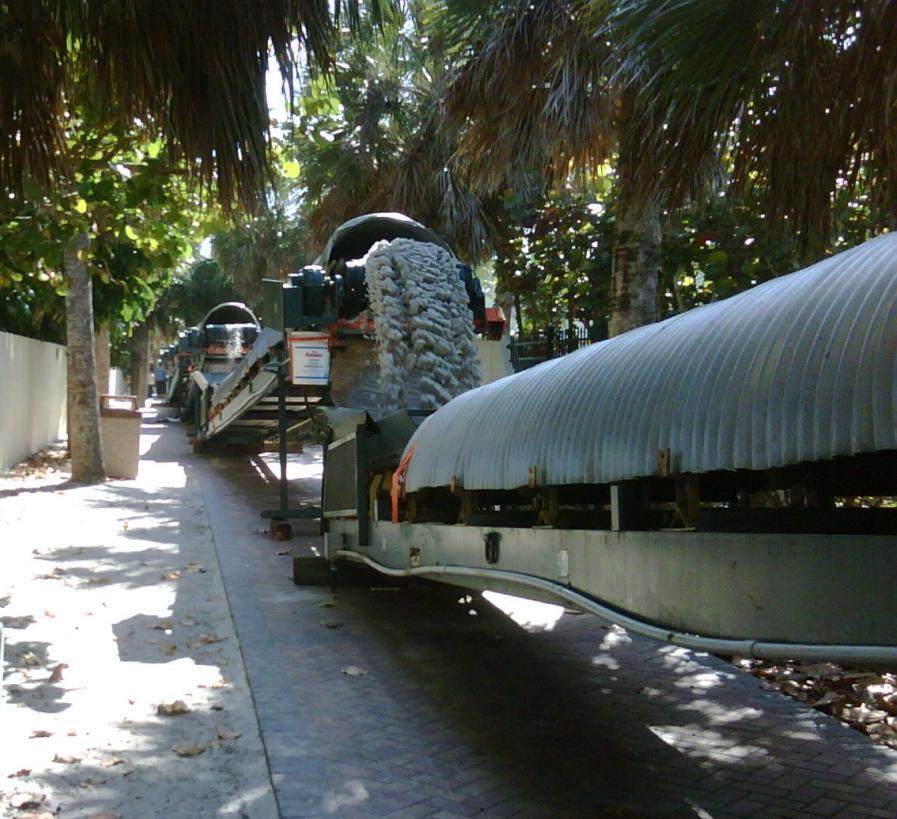
44 44 CONVEYOR SYSTEM: Images Provided By: Eastman Aggregates Inc.

45 Tracking No Comparison Between Long Term Projects Truck Haul vs. Dredging Projects Look at Scale of Cost Look at any permanent infrastructure that could make one of these more cost efficient Sustainability


46 Tracking No Types of Beach Fill Projects: Mitigate Long-Term Erosion Storm Damage Reduction


 USGS")
47 Tracking No Storm Damage Reduction Before Fran (After Bertha) USGS After Fran USGS

48 Tracking No Storm Damage Reduction
49 Tracking No
50 Tracking No ELEVATION PROFILE EVOLUTION OF BEACH NOURISHMENT DISTANCE
51 Tracking No ELEVATION PROFILE EVOLUTION OF BEACH NOURISHMENT 10 Nourishment 0-10 Design Beach DISTANCE
52 Tracking No ELEVATION PROFILE EVOLUTION OF BEACH NOURISHMENT 10 Advance Fill 0-10 Design Beach DISTANCE
53 Tracking No ELEVATION PROFILE EVOLUTION OF BEACH NOURISHMENT Design Beach DISTANCE
54 Tracking No ELEVATION PROFILE EVOLUTION OF BEACH NOURISHMENT Design Beach DISTANCE

55 Tracking No ELEVATION PROFILE EVOLUTION OF BEACH NOURISHMENT 10 Post-Construction Adjustment in 1-3 years 0-10 Design Beach DISTANCE
56 56
57 57 Approx. February 1993 Wet/Dry Line

58 58 Approx. February 1993 Wet/Dry Line

59 59 Approx. February 1993 Wet/Dry Line
60 60
61 61 Storm Vulnerability
62 62
63 63 SBEACH Storm-induced BEAch CHange Model Simulates cross-shore erosion of the dune, berm, and foreshore caused by storm waves and water levels
64 85M102006D Omaha Beach FS18 (Sta ) Thule St 100 Year Return Interval Storm
65 85M102006D Omaha Beach FS18 (Sta ) Thule St 100 Year Return Interval Storm
66 85M102006D Omaha Beach FS18 (Sta ) Thule St 100 Year Return Interval Storm Post-Storm Profile
67 85M102006D Omaha Beach FS18 (Sta ) Thule St 100 Year Return Interval Storm Beach Fill: Alternative 1 & 3
68 85M102006D Omaha Beach FS18 (Sta ) Thule St 100 Year Return Interval Storm Post-Storm Profile: Alternative 1 & 3
69 85M102006D Omaha Beach FS18 (Sta ) Thule St 100 Year Return Interval Storm Post-Storm Profile: Alternative 1 & 3
70 85M102006D Omaha Beach FS18 (Sta ) Thule St 100 Year Return Interval Storm Post-Storm Profile
71 71 Summary Phase 1 analysis is generally complete, report being prepared Concepts to be vetted for Phase 2 have been outlined Over the next 2 months we will finish Phase 2 Recommend considering SBEACH analysis to determine storm vulnerability for entire town

72 72 Thank You For Your Time!! Questions? Tom Jarrett Robert Neal Ken Willson
73 73
Town of Duck, North Carolina
 Tracking No. 00.00.2010 Erosion Mitigation And Shoreline Management Feasibility Study Town of Duck, North Carolina Coastal Planning & Engineering of North Carolina February 28, 2013 Ken Willson 1 Tracking
Table 4. Volumetric Change Rates Pre-Project and Post-Project for the Town of Duck
 V. VOLUMETRIC CHANGES General Volumetric changes measured over the entire monitoring area for various time periods are provided in Table 4. The volume changes are given in terms of cubic yards/foot of
North Shore of Long Island, Feasibility Study
 North Shore of Long Island, Asharoken New York Asharoken, Feasibility Study Asharoken, NY Public Meeting June 30, 2015 US Army Corps of Engineers US Army Corps of Engineers New York BUILDING STRONG BUILDING
Figure79. Location map for the 10 NJBPN profile sites in Atlantic County, NJ 155
 154 Figure79. Location map for the 10 NJBPN profile sites in Atlantic County, NJ 155 ATLANTIC COUNTY SPRING 2009 to FALL 2010 The Atlantic County coastline consists of three barrier islands. Between Little
RE: Hurricane Matthew Beach Damage Assessment and Recommendations [CSE 2416]
![RE: Hurricane Matthew Beach Damage Assessment and Recommendations [CSE 2416]](/thumbs/83/87675702.jpg "RE: Hurricane Matthew Beach Damage Assessment and Recommendations [CSE 2416]") October 25, 2016 Iris Hill Town Administrator Town of Edisto Beach 2414 Murray St Edisto Beach SC 29438 RE: Hurricane Matthew Beach Damage Assessment and Recommendations [CSE 2416] Dear Iris, Hurricane
October 25, 2016 Iris Hill Town Administrator Town of Edisto Beach 2414 Murray St Edisto Beach SC 29438 RE: Hurricane Matthew Beach Damage Assessment and Recommendations [CSE 2416] Dear Iris, Hurricane
Beach Restoration in Okaloosa and Walton Counties. FSBPA Technology Conference Clearwater, FL
 Beach Restoration in Okaloosa and Walton Counties FSBPA Technology Conference Clearwater, FL Presented by: Duncan Greer, E.I. February 5, 2015 PRESENTATION OUTLINE 1. Overview of Project Locations 2. Eglin
SACO RIVER AND CAMP ELLIS BEACH SACO, MAINE SECTION 111 SHORE DAMAGE MITIGATION PROJECT APPENDIX F ECONOMIC ASSESSMENT
 SACO RIVER AND CAMP ELLIS BEACH SACO, MAINE SECTION 111 SHORE DAMAGE MITIGATION PROJECT APPENDIX F ECONOMIC ASSESSMENT Department of the Army New England District, Corps of Engineers 696 Virginia Road
Dare County Nourishment Project Town of Duck
 Dare County Nourishment Project Town of Duck Julien Devisse, P.E. and Ken Willson CB&I / Coastal Planning & Engineering of North Carolina, Inc. February 15, 2017 A World of Solutions Outline Background
Jimmy s beach preliminary results
 Jimmy s beach preliminary results LP 668979 Jimmy s Beach Restoration Society 1 Outline 1. Long term: GIS analyses. Aerial photos, charts Shoreline analyses Storm data from MHL/DECC 2. Medium term: morphologic
UPPER BEACH REPLENISHMENT PROJECT RELATED
 ASSESSMENT OF SAND VOLUME LOSS at the TOWNSHIP of UPPER BEACH REPLENISHMENT PROJECT RELATED to the LANDFALL OF HURRICANE SANDY - PURSUANT TO NJ-DR 4086 This assessment is in response to Hurricane Sandy
CROSS-SHORE SEDIMENT PROCESSES
 The University of the West Indies Organization of American States PROFESSIONAL DEVELOPMENT PROGRAMME: COASTAL INFRASTRUCTURE DESIGN, CONSTRUCTION AND MAINTENANCE A COURSE IN COASTAL DEFENSE SYSTEMS I CHAPTER
Climate Change Impacts to KSC Launch Complex
 Climate Change Impacts to KSC Launch Complex Presented to: 2010 International Workshop on Environment and Energy By: John Shaffer NASA Environmental Management Branch Kennedy Space Center Hurricane Season
HURRICANE SANDY LIMITED REEVALUATION REPORT UNION BEACH, NEW JERSEY DRAFT ENGINEERING APPENDIX SUB APPENDIX D SBEACH MODELING
 HURRICANE SANDY LIMITED REEVALUATION REPORT UNION BEACH, NEW JERSEY DRAFT ENGINEERING APPENDIX SUB APPENDIX D SBEACH MODELING Rev. 18 Feb 2015 1 SBEACH Modeling 1.0 Introduction Following the methodology
23- Year Sand Volume Changes at Site 132, 15th Street, Brigantine
 149 Figure75. Location map for the 9 NJBPN profile sites in Atlantic County, NJ ATLANTIC COUNTY SPRING 2008 to FALL 2009 150 The Atlantic County oceanfront shoreline consists of three barrier islands.
Figure 262. Location map for the 10 NJBPN profile sites in Atlantic County, NJ 279
 278 Figure 262. Location map for the 10 NJBPN profile sites in Atlantic County, NJ 279 ATLANTIC COUNTY SUMMARY The Atlantic County coastline consists of three barrier islands. The island of Little Beach
ST. JOSEPH PENINSULA, GULF COUNTY, FLORIDA Beach Re-Nourishment and Environmental Enhancement Project RECOMMENDATIONS
 ST. JOSEPH PENINSULA, GULF COUNTY, FLORIDA Beach Re-Nourishment and Environmental Enhancement Project RECOMMENDATIONS January 23, 2018 543 Harbor Boulevard, Suite 204 Destin, Florida 32541 850.654.1555
Beach Nourishment Impact on Beach Safety and Surfing in the North Reach of Brevard County, Florida
 Beach Nourishment Impact on Beach Safety and Surfing in the North Reach of Brevard County, Florida Prepared by John Hearin, Ph.D. Coastal Engineering Vice Chairman Cocoa Beach Chapter Port Canaveral Patrick
Inlet Management Study for Pass-A-Grille and Bunces Pass, Pinellas County, Florida
 Inlet Management Study for Pass-A-Grille and Bunces Pass, Pinellas County, Florida Final Report Submitted By Ping Wang, Ph.D., Jun Cheng Ph.D., Zachary Westfall, and Mathieu Vallee Coastal Research Laboratory
New Jersey Beach Profile Network Atlantic County Profile Site Locations
 215 RICHARD STOCKTON COLLEGE OF NEW JERSEY New Jersey Beach Profile Network Atlantic County Profile Site Locations COASTAL RESEARCH CENTER Figure 128 There are nine NJBPN survey sites on the Atlantic County
Volume and Shoreline Changes along Pinellas County Beaches during Tropical Storm Debby
 Volume and Shoreline Changes along Pinellas County Beaches during Tropical Storm Debby Ping Wang and Tiffany M. Roberts Coastal Research Laboratory University of South Florida July 24, 2012 Introduction
Beach Renourishment in Jacksonville
 Beach Renourishment in Jacksonville Kevin Bodge, PhD, P.E. - Olsen Associates, Inc. 1978 Oct 2004 2000 2016 2011 Oct 2016 Coastal Duval County, FL Nassau Sound Blount Island Ft. George Inlet St. Johns
Modeling Sediment Transport Along the Upper Texas Coast
 Modeling Sediment Transport Along the Upper Texas Coast David B. King Jr. Jeffery P. Waters William R. Curtis Highway 87 roadbed, Jefferson County Galveston District Corps Sabine Pass to San Luis Pass
Dune Monitoring Data Update Summary: 2013
 Dune Monitoring Data Update Summary: 13 Shoreline Studies Program Virginia Institute of Marine Science College of William & Mary Gloucester Point, Virginia September 13 Dune Monitoring Data Update Summary:
Atlantic Coast of Long Island, Jones Inlet to East Rockaway Inlet, Long Beach Island, NY Construction Update
 Atlantic Coast of Long Island, Jones Inlet to East Rockaway Inlet, Long Beach Island, NY Construction Update June 2016 US Army Corps of Engineers Project Purpose Three specific damage mechanisms of coastal
Figure 46. Locations of the 28 NJBPN profile stations in Ocean County, NJ. A new site was added in the Borough of Seaside Heights (#248).
.") 90 Figure 46. Locations of the 28 NJBPN profile stations in Ocean County, NJ. A new site was added in the Borough of Seaside Heights (#248). 91 OCEAN COUNTY SPRING 2008 to FALL 2009 The Ocean County shoreline
90 Figure 46. Locations of the 28 NJBPN profile stations in Ocean County, NJ. A new site was added in the Borough of Seaside Heights (#248). 91 OCEAN COUNTY SPRING 2008 to FALL 2009 The Ocean County shoreline
City of Del Mar Local Coastal Plan (LCP) Amendment for Sea Level Rise and Coastal Flooding
 Amendment for Sea Level Rise and Coastal Flooding") City of Del Mar Local Coastal Plan (LCP) Amendment for Sea Level Rise and Coastal Flooding 6/22/17 Presentation to Sea Level Rise Stakeholder- Technical Advisory Committee (STAC) Nick Garrity, P.E. Lindsey
City of Del Mar Local Coastal Plan (LCP) Amendment for Sea Level Rise and Coastal Flooding 6/22/17 Presentation to Sea Level Rise Stakeholder- Technical Advisory Committee (STAC) Nick Garrity, P.E. Lindsey
Coastal Inundation. An Overview for TCDC
 Coastal Inundation An Overview for TCDC Rick Liefting Team Leader Regional Hazards and Environmental Compliance Integrated Catchment Management Waikato Regional Council Photo: Sugar Loaf Wharf, Coromandel.
STATE OF THE COAST 2016 Coastal Frontiers Corporation June 1, 2017
 STATE OF THE COAST 2016 Coastal Frontiers Corporation June 1, 2017 Shoreline Preservation Committee 1. Background OVERVIEW 2. Monitoring Program 3. Results 2015-16 El Niño Post-RBSP II Post-RBSP I 4. Conclusions
ATLANTIC COAST OF LONG ISLAND, JONES INLET TO EAST ROCKAWAY INLET, LONG BEACH ISLAND, NY. Contract #2 Construction Scope. April 18th-19th 2018
 ATLANTIC COAST OF LONG ISLAND, JONES INLET TO EAST ROCKAWAY INLET, LONG BEACH ISLAND, NY Contract #2 Construction Scope April 18th-19th 2018 New York District PLAN COMPONENTS Length of Beachfill 35,000
PLAQUEMINES PARISH BARRIER ISLAND RESTORATION & SUSTAINABILITY. MVD/Gulf Coast Regional Dredging Meeting November 5, 2013
 PLAQUEMINES PARISH BARRIER ISLAND RESTORATION & SUSTAINABILITY MVD/Gulf Coast Regional Dredging Meeting November 5, 2013 OVERVIEW 1. Barrier Island Restoration Projects in Plaquemines Parish 2. Plaquemines
Pathways Interns: Annika O Dea, Ian Conery, Andrea Albright
 1 REMOTE SENSING OF COASTAL MORPHODYNAMICS 237 237 237 217 217 217 2 2 2 8 119 27 252 174.59 255 255 255 163 163 163 131 132 122 239 65 53 11 135 12 112 92 56 62 12 13 12 56 48 13 12 111 Kate Brodie Brittany
Assateague Island National Seashore North End Restoration Project Timeline
 Assateague Island National Seashore North End Restoration Project Timeline Date Event Some information provided in the Project Introduction document. Detailed events are available in a timeline compiled
Coastal Hazards and Management in North Carolina. Braxton Davis April 14, 2015
 Coastal Hazards and Management in North Carolina Braxton Davis April 14, 2015 Coastal Facts and Figures 320 miles of ocean beaches 12,000+ miles of estuarine shoreline 2 million + acres of sounds, creeks,
Long Beach Island Holgate Spit Little Egg Inlet Historical Evolution Introduction Longshore Transport Map, Survey and Photo Historic Sequence
 Appendix B Long Beach Island Holgate Spit Little Egg Inlet Historical Evolution Introduction The undeveloped southern end of Long Beach Island (LBI) is referred to as the Holgate spit as it adjoins the
FINDING OF NO SIGNIFICANT IMPACT
 DEPARTMENT OF THE ARMY CHARLESTON DISTRICT, CORPS OF ENGINEERS 69A HAGOOD AVENUE CHARLESTON, SOUTH CAROLINA 29403-5107 FINDING OF NO SIGNIFICANT IMPACT EDISTO BEACH COASTAL STORM DAMAGE REDUCTION GENERAL
SFM mapping of coastal erosion at Point Woronzof. Gennady Gienko, PhD Department of Geomatics, UAA
 SFM mapping of coastal erosion at Point Woronzof Gennady Gienko, PhD Department of Geomatics, UAA ggienko@alaska.edu POINT WORONZOF Point Woronzof bluff 135 ft elevation Point Woronzof bluff Pt. Woronzof
April 7, Prepared for: The Caribbean Disaster Emergency Response Agency Prepared by: CEAC Solutions Co. Ltd.
 April 7, 2006 Prepared for: The Caribbean Disaster Emergency Response Agency Prepared by: Introduction CEAC Solutions Co. Ltd was commissioned in May 2005 to prepare coastal beach erosion hazard maps for
Estimating Beach Volume Change as a function of Beach Profile Spacing
 Estimating Beach Volume Change as a function of Beach Profile Spacing Kevin R. Bodge, Ph.D., P.E. William Reilly, P.E. and Patrick Snyder, P.E. Steve Howard, P.E. Bill Hobensack, P.E. Chris Creed, P.E.
PRESSURE EQUALISATION MODULES FOR ENVIRONMENTALLY FRIENDLY COASTAL PROTECTION
 PRESSURE EQUALISATION MODULES FOR ENVIRONMENTALLY FRIENDLY COASTAL PROTECTION Poul Jakobsen Skagen Innovation Centre, Dronning Alexandrinesvej 7, DK - 999 Skagen, Denmark Abstract Land-based activities
CLAM PASS RESTORATION AND MANAGEMENT PLAN BATHYMETRIC MONITORING REPORT NO. 7 Including Interior Bay Dredge Cuts and Tidal Data
 CLAM PASS RESTORATION AND MANAGEMENT PLAN BATHYMETRIC MONITORING REPORT NO. 7 Including Interior Bay Dredge Cuts and Tidal Data Submitted to: Florida Department of Environmental Protection DEP File No.
The purpose and needs of the Figure Eight Island Inlet and Shoreline Management Project are as follows:
 Chapter 2 PURPOSE AND NEEDS 1. What are the purpose and needs of this project? The main concern of residents and owners at Figure Eight Island are economic losses resulting from damages to structures and
FEMA Region V. Great Lakes Coastal Flood Study. Pilot Study Webinar. Berrien County, Michigan. February 26, 2014
 FEMA Region V Great Lakes Coastal Flood Study Pilot Study Webinar Berrien County, Michigan February 26, 2014 2 Pilot Study Webinar Agenda Great Lakes Coastal Flood Study Background Demonstration Project
Southwest Washington Littoral Drift Restoration Project: Design, Construction, and Monitoring
 Southwest Washington Littoral Drift Restoration Project: Design, Construction, and Monitoring J Jessica i St Stokke kk USACE Portland District October 28, 2010 WEDA Pacific Meeting Monterey, CA US Army
Building Beaches with Navigation Sand, Just Don t Forget the Dunes!!
 Building Beaches with Navigation Sand, Just Don t Forget the Dunes!! Ken Willson Kenneth.Willson@CBI.com Introduction Decrease in Federal Funding (Shallow Draft Navigation Maintenance and Shore Protection)
Recycling of Surplus Sand to Extend the Time Between Beach Fill Episodes
 Recycling of Surplus Sand to Extend the Time Between Beach Fill Episodes Cape May County, New Jersey Dr. Stewart Farrell Coastal Research Center 1795 Franklin Map Shows Inlets Inlet Morphology has Remained
CHAPTER 281 INFLUENCE OF NEARSHORE HARDBOTTOM ON REGIONAL SEDIMENT TRANSPORT
 CHAPTER 281 INFLUENCE OF NEARSHORE HARDBOTTOM ON REGIONAL SEDIMENT TRANSPORT Paul C.-P. Lin, Ph.D., P.E. 1 and R. Harvey Sasso, P.E. 2 ABSTRACT The influence of nearshore hardbottom on longshore and cross-shore
APPENDIX A Coastal Engineering
 1 1 INTEGRATED FEASIBILITY REPORT AND ENVIRONMENTAL IMPACT STATEMENT COASTAL STORM DAMAGE REDUCTION BOGUE BANKS, CARTERET COUNTY NORTH CAROLINA 1 1 1 1 APPENDIX A Coastal Engineering 1 1 0 US Army Corps
COASTAL MORPHODYNAMICS
 COASTAL MORPHODYNAMICS PATRICIA CHARDÓN-MALDONADO, PHD, EIT Miguel Canals, Jack A. Puleo, Alec Torres-Freyermuth & Jens Figlus March 9, 2017 OUTLINE INTRODUCTION Meteorological Phenomena Forcing Conditions
DELAWARE S VULNERABLE COASTAL AREAS. DELAWARE INLAND BAYS and DELAWARE BAY RECONNAISSANCE STUDY
 DELAWARE S VULNERABLE COASTAL AREAS and the DELAWARE INLAND BAYS and DELAWARE BAY RECONNAISSANCE STUDY Kimberly K. McKenna, PG Delaware Dept. of Natural Resources & Environmental Control Division of Watershed
Chapter 15 SEASONAL CHANGES IN BEACHES OP THE NORTH ATLANTIC COAST OF THE UNITED STATES
 Chapter 15 SEASONAL CHANGES IN BEACHES OP THE NORTH ATLANTIC COAST OF THE UNITED STATES By John M. Darling Hydraulic Engineer, Research Division U. S. Army Coastal Engineering Research Center Corps of
ENVIRONMENTAL ASSESSMENT
 Draft January 2015 ENVIRONMENTAL ASSESSMENT For the Town of Kitty Hawk Shore Protection Project ENVIRONMENTAL ASSESSMENT TOWN OF KITTY HAWK SHORE PROTECTION PROJECT Prepared for: The Town of Kitty Hawk,
New Jersey Beach Profile Network Ocean County Profile Site Locations
 125 RICHARD STOCKTON COLLEGE OF NEW JERSEY COASTAL RESEARCH CENTER New Jersey Beach Profile Network Ocean County Profile Site Locations Figure 73 156 155 154 153 152 151 15 149 The Ocean County shoreline
Tanya M. Beck. Kelly Legault. Research Physical Scientist Coastal & Hydraulics Lab, ERDC Vicksburg, MS
 Inlet And Adjacent Shoreline Processes at Cascading Time Scales Using the Coastal Modeling System and GenCade Tanya M. Beck Research Physical Scientist Coastal & Hydraulics Lab, ERDC Vicksburg, MS Kelly
Q1. What are the primary causes/contributors to coastal erosion at Westshore and the concept of longshore / littoral drift.
 Q1. What are the primary causes/contributors to coastal erosion at Westshore and the concept of longshore / littoral drift. In order of (timing related) contribution to present problem 1. Beach is too
Sediment Transport Analysis Village of Asharoken, New York
 Sediment Transport Analysis Village of Asharoken, New York NORTH SHORE OF LONG ISLAND, NEW YORK COMBINED EROSION CONTROL AND STORM DAMAGE PROTECTION FEASIBILITY STUDY FINAL REPORT August 2004 Cell 0 Asharoken
Effectiveness of Beach Nourishment in Response to Sea Level Rise
 2014 FSBPA Annual Conference Effectiveness of Beach Nourishment in Response to Sea Level Rise Navarre Beach Santa Rosa County July 18, 2005 Lovers Key Lee County April 23, 2012 South County St. Lucie County
Reading Material. Inshore oceanography, Anikouchine and Sternberg The World Ocean, Prentice-Hall
 Reading Material Inshore oceanography, Anikouchine and Sternberg The World Ocean, Prentice-Hall BEACH PROCESSES AND COASTAL ENVIRONMENTS COASTAL FEATURES Cross section Map view Terminology for Coastal
OECS Regional Engineering Workshop September 29 October 3, 2014
 B E A C H E S. M A R I N A S. D E S I G N. C O N S T R U C T I O N. OECS Regional Engineering Workshop September 29 October 3, 2014 Coastal Erosion and Sea Defense: Introduction to Coastal/Marine Structures
New Jersey Coastal Zone Overview. The New Jersey Beach Profile Network (NJBPN) 3 Dimensional Assessments. Quantifying Shoreline Migration
 3 Dimensional Assessments. Quantifying Shoreline Migration") New Jersey Coastal Zone Overview The New Jersey Beach Profile Network (NJBPN) Objectives Profile Locations Data Collection Analyzing NJBPN Data Examples 3 Dimensional Assessments Methodology Examples Quantifying
New Jersey Coastal Zone Overview The New Jersey Beach Profile Network (NJBPN) Objectives Profile Locations Data Collection Analyzing NJBPN Data Examples 3 Dimensional Assessments Methodology Examples Quantifying
SPECIAL SPRING 2018 STORM REPORT ON THE CONDITION OF THE MUNICIPAL BEACHES FOR THE BOROUGH OF STONE HARBOR, CAPE MAY COUNTY, NEW JERSEY
 SPECIAL SPRING 2018 STORM REPORT ON THE CONDITION OF THE MUNICIPAL BEACHES FOR THE BOROUGH OF STONE HARBOR, CAPE MAY COUNTY, NEW JERSEY Aerial photograph taken April 21, 2018 showing the view up the beach
EROSION MECHANICS OF A CARBONATE- TOMBOLO BEACH IN MIYAKOJIMA ISLAND, OKINAWA PREFECTURE, JAPAN.
 EROSION MECHANICS OF A CARBONATE- TOMBOLO BEACH IN MIYAKOJIMA ISLAND, OKINAWA PREFECTURE, JAPAN. Ryuichiro NISHI 1, Takaaki UDA 2, Akio KIKUCHI 3 and Kou FURUIKE 4 1) Associate Prof. Dept. of Ocean Civil
Broad Beach Sand & Dune Habitat Restoration Project. Revetment Owners Meeting July 12, 2017
 Broad Beach Sand & Dune Habitat Restoration Project Revetment Owners Meeting July 12, 2017 Status of Project Entitlement Coastal Commission CDP approved 10/15 (consolidated with City of Malibu), PTI conditions
SEDIMENT BUDGET OF LIDO OF PELLESTRINA (VENICE) Written by Marcello Di Risio Under the supervision of Giorgio Bellotti and Leopoldo Franco
 Written by Marcello Di Risio Under the supervision of Giorgio Bellotti and Leopoldo Franco") SEDIMENT BUDGET OF LIDO OF PELLESTRINA (VENICE) Written by Marcello Di Risio Under the supervision of Giorgio Bellotti and Leopoldo Franco Table of contents: 1. Introduction...3 2. Protection structures
SEDIMENT BUDGET OF LIDO OF PELLESTRINA (VENICE) Written by Marcello Di Risio Under the supervision of Giorgio Bellotti and Leopoldo Franco Table of contents: 1. Introduction...3 2. Protection structures
Salt Ponds Shore Zone Modeling for Breakwater Placement: Summary Report
 Salt Ponds Shore Zone Modeling for Breakwater Placement: Summary Report Virginia Institute of Marine Science May 2014 Salt Ponds Shore Zone Modeling for Breakwater Placement: Summary Report For Waterway
FINAL REPORT FOR 2013 ON THE CONDITION OF THE MUNICIPAL OCEANFRONT BEACHES THE BOROUGH OF AVALON, CAPE MAY COUNTY, NEW JERSEY
 FINAL REPORT FOR 2013 ON THE CONDITION OF THE MUNICIPAL OCEANFRONT BEACHES THE BOROUGH OF AVALON, CAPE MAY COUNTY, NEW JERSEY View from 12 th Street to the south taken February 28, 2013, following completion
Follets Island Nearshore Beach Nourishment Project
 Coast & Harbor Engineering A division of Hatch Mott MacDonald Follets Island Nearshore Beach Nourishment Project Arpit Agarwal, P.E. April 1, 2016 Project Site!"#$% &'(% &)*+% )#,'-+% Shoreline Erosion
Regular Workshop October 20, 2014 Agenda Item: Dr. Albert E. Browder, PE; Olsen Associates, Inc.
 Regular Workshop October 20, 2014 Agenda Item 8 Agenda Item: Presenter: Summary: Beach Update Town Manager; Dr. Albert E. Browder, PE; Olsen Associates, Inc. At the January 21, 2014 Regular Workshop Meeting,
Trusted Partners Delivering Value, Today and Tomorrow BUILDING STRONG
 Miami-Dade County Renourishment Project U.S. Army Corps of Engineers Jacksonville District January 5, 2017 US Army Corps of Engineers Project Purpose coastal storm risk management beach erosion control
AN OVERVIEW OF RECENT PROJECTS RELATED TO SAND BUDGETS, SOUTHERN CALIFORNIA BEACHES
 AN OVERVIEW OF RECENT PROJECTS RELATED TO SAND BUDGETS, SAND SUPPLY, COASTAL ARMORING, MANAGEMENT, AND VALUING SOUTHERN CALIFORNIA BEACHES Dr. Kiki Patsch California State University Channel Islands Environmental
Compiled by Uwe Dornbusch. Edited by Cherith Moses
 REPORT ON WAVE AND TIDE MEASUREMENTS Compiled by Uwe Dornbusch. Edited by Cherith Moses 1 Aims...1 2 Summary...1 3 Introduction...1 4 Site selection...1 5 Wave recorder settings...2 6 Results...2 6.1 Water
ATLANTIC COUNTY 2006 to 2008
 ATLANTIC COUNTY 2006 to 2008 The Atlantic County oceanfront shoreline consists of three barrier islands where the northern one, Little Beach Island and a third of the second, Brigantine Island, are undeveloped
Chapter 10 Field Survey and Sediment Analysis for the Candidate Site
 Chapter 1 Field Survey and Sediment Analysis for the Candidate Site 1.1 Overview Several kinds of field surveys have been carried out to obtain the necessary information for sediment analysis, planning,
Long Term Success and Future Approach of the Captiva and Sanibel Islands Beach Renourishment Program
 2017 National Conference on Beach Preservation Technology February 8-10, 2017; Stuart, Florida Long Term Success and Future Approach of the Captiva and Sanibel Islands Beach Renourishment Program Thomas
Sea Level Rise and Coastal Flooding Why Waves Matter!
 Sea Level Rise and Coastal Flooding Why Waves Matter! Jason D. Burtner Massachusetts Office of Coastal Zone Management South Shore Regional Coordinator Sea Level Rise and Coastal Storm Damage and Flooding
Inventory of coastal sandy areas protection of infrastructure and planned retreat
 2018-02-28 Inventory of coastal sandy areas protection of infrastructure and planned retreat Johanna Birgander, Thorbjörn Nilsson, Pär Persson Summary To estimate the natural protection around the coast
Artificial Beach Nourishment: Lessons learned from Field Experiments Hans Kunz
 Artificial Beach Nourishment: Lessons learned from Field Experiments Hans Kunz International Conference Development of Artificial Lands on Shores, Near-Shore and Off-Shore Zones Novosibirsk, Russia, July
Evaluation Report Teluk Chempedak Oct 2005
 Evaluation Report Teluk Chempedak Oct 2005 Beach Nourishment combined with the SIC System Hyatt Hotel SIC Skagen Innovation Centre Dr. Alexandrinesvej 75 Dk 9990 Skagen Denmark Phone 00 45 98 44 57 13
BEACH NOURISHMENT COMBINED WITH SIC VERTICAL DRAIN IN MALAYSIA. Claus Brøgger 1 and Poul Jakobsen 2
 BEACH NOURISHMENT COMBINED WITH SIC VERTICAL DRAIN IN MALAYSIA. Claus Brøgger 1 and Poul Jakobsen 2 The present paper presents measurements and results from a three year full scale Pilot Project with the
Mouth of the Columbia River Jetties Three-Phase Construction Plan
 Mouth of the Columbia River Jetties Three-Phase Construction Plan Project Overview October 9, 2012 US Army Corps of Engineers MCR Jetties Major Rehabilitation Sand Island pile dikes 1930-1935 Columbia
2014 ANNUAL REPORT - TO THE CITY OF NORTH WILDWOOD ON THE CONDITION OF THE CITY BEACHES
 2014 ANNUAL REPORT - TO THE CITY OF NORTH WILDWOOD ON THE CONDITION OF THE CITY BEACHES View on September 25, 2014 looking northwest into Hereford Inlet. Considerable southerly expansion of the tip of
FINAL REPORT FOR 2009 ON THE CONDITION OF THE MUNICIPAL OCEANFRONT BEACHES IN THE BOROUGH OF AVALON, CAPE MAY COUNTY, NEW JERSEY
 FINAL REPORT FOR 2009 ON THE CONDITION OF THE MUNICIPAL OCEANFRONT BEACHES IN THE BOROUGH OF AVALON, CAPE MAY COUNTY, NEW JERSEY Storm waves pound the inlet revetment September 10, 2009 as the series of
Bob Battalio, PE Chief Engineer, ESA September 8, 2016
 RELATING FUTURE COASTAL CONDITIONS TO EXISTING FEMA FLOOD HAZARD MAPS Technical Methods Manual Bob Battalio, PE Chief Engineer, ESA September 8, 2016 FMA 2016 Sacramento, California DWR-OST-SIO PILOTING
USE OF SEGMENTED OFFSHORE BREAKWATERS FOR BEACH EROSION CONTROL
 .. CETN-III-22 4/84 PURPOSE: USE OF SEGMENTED OFFSHORE BREAKWATERS FOR BEACH EROSION CONTROL To provide information on the functional application of and general design considerations for using offshore
Louisiana CPRA SJB Group, Baton Rouge Coastal Engineering Consultants U.S. Army Corps of Engineers Federal and State PDT Members
 Louisiana CPRA SJB Group, Baton Rouge Coastal Engineering Consultants U.S. Army Corps of Engineers Federal and State PDT Members Project Setting and Background Island Restoration Plans Pre-Screening Analysis
Performance of Upham Beach T-Groin Project and Its Impact to the Downdrift Beach
 Performance of Upham Beach T-Groin Project and Its Impact to the Downdrift Beach Progress Report for the Period of October 2008 to April 2009 Submitted by Ping Wang, Ph.D., and Tiffany M. Roberts Department
Southern California Beach Processes Study
 Southern California Beach Processes Study Torrey Pines Field Site 5th Quarterly Report 31 May 22 to California Resources Agency and California Department of Boating and Waterways R.T. Guza 1, W.C. O Reilly
County of Santa Barbara Permit Option Analysis Goleta Beach JULY 13, 2017
 County of Santa Barbara Permit Option Analysis Goleta Beach JULY 13, 2017 Introduction 2 Goleta Beach Park welcomes 1.5 million visitors annually Amenities include: Picnic Areas and Group Areas w/bbqs
Navarre Beach & Dune Restoration Project Status Report to be regularly updated June 17, 2016 Report
 Navarre Beach & Dune Restoration Project Status Report to be regularly updated June 17, 2016 Report Work Completed (June 11 to June 17) Weeks Marine Inc. (Contractor): o continued filling Segment 4 including
Figure 38. Locations of the 28 NJBPN profile stations in Ocean County, NJ.
 55 Figure 38. Locations of the 28 NJBPN profile stations in Ocean County, NJ. 56 Individual Site Descriptions: Northern Ocean County recovered its beaches approaching pre-hurricane Sandy elevation or width,
A Summary of the 2017 State of Maine s Beaches Report
 Maine Geologic Facts and Localities July, 2017 A Summary of the 2017 State of Maine s Beaches Report William Van Benthuysen, Kennebunkport, Maine Text by Peter A. Slovinsky, Department of Agriculture,
STATUS REPORT FOR THE SUBMERGED REEF BALL TM ARTIFICIAL REEF SUBMERGED BREAKWATER BEACH STABILIZATION PROJECT FOR THE GRAND CAYMAN MARRIOTT HOTEL
 August 23 STATUS REPORT FOR THE SUBMERGED REEF BALL TM ARTIFICIAL REEF SUBMERGED BREAKWATER BEACH STABILIZATION PROJECT FOR THE GRAND CAYMAN MARRIOTT HOTEL performed by Lee E. Harris, Ph.D., P.E. Consulting
ALTERNATIVES FOR COASTAL STORM DAMAGE MITIGATION
 ALTERNATIVES FOR COASTAL STORM DAMAGE MITIGATION Dave Basco Old Dominion University, Norfolk, Virginia, USA National Park Service Photo STRUCTURAL (changes to natural, physical system) hardening (seawalls,
Boothbay Harbor Rotary Club May 12, 2016
 Mapping Potential Sea Level Rise and Storm Surge in Boothbay Harbor, ME Boothbay Harbor Rotary Club May 12, 2016 Peter A. Slovinsky, Marine Geologist Maine Geological Survey S.M. Dickson, MGS Quickly,
SAND BYPASSING RESTORES NATURAL PROCESSES TO ASSATEAGUE ISLAND, MARYLAND
 SAND BYPASSING RESTORES NATURAL PROCESSES TO ASSATEAGUE ISLAND, MARYLAND Courtney A. Schupp 1, Gregory P. Bass 2, William G. Grosskopf 3 1. Assateague Island National Seashore, 7206 National Seashore Lane,
SELECTION OF THE PREFERRED MANAGEMENT OPTION FOR STOCKTON BEACH APPLICATION OF 2D COASTAL PROCESSES MODELLING
 SELECTION OF THE PREFERRED MANAGEMENT OPTION FOR STOCKTON BEACH APPLICATION OF 2D COASTAL PROCESSES MODELLING C Allery 1 1 DHI Water and Environment, Sydney, NSW Abstract This paper presents an approach
MULTIDECADAL SHORELINE EVOLUTION DUE TO LARGE-SCALE BEACH NOURISHMENT JAPANESE SAND ENGINE? Abstract
 MULTIDECADAL SHORELINE EVOLUTION DUE TO LARGE-SCALE BEACH NOURISHMENT JAPANESE SAND ENGINE? Masayuki Banno 1, Satoshi Takewaka 2 and Yoshiaki Kuriyama 3 Abstract Beach nourishment is one of the countermeasures
STORM RESPONSE SIMULATION
 APPENDIX V STORM RESPONSE SIMULATION Final Environmental Impact Statement Village of Bald Head Island Shoreline Protection Project Brunswick County, North Carolina Delft3D Storm Response Simulations With
Appendix E Cat Island Borrow Area Analysis
 Appendix E Cat Island Borrow Area Analysis ERDC/CHL Letter Report 1 Cat Island Borrow Area Analysis Multiple borrow area configurations were considered for Cat Island restoration. Borrow area CI1 is located
Beach Nourishment, Static Lines, and Static Line Exceptions
 Beach Nourishment, Static Lines, and Static Line Exceptions Matt Slagel, Shoreline Management Specialist Coastal Resources Commission February 26, 2014 Nags Head Defining the Static Line Defining the Static
Trends in Shoreline Change and Hazard Impacts: Hot Spots and Management Challenges. Greg Berman CAPE COASTAL CONFERENCE.
 CAPE COASTAL CONFERENCE Linking Science with Local Solu1ons and Decision- Making Trends in Shoreline Change and Hazard Impacts: Hot Spots and Management Challenges Presented By Greg Berman (WHOI Sea Grant