SFM mapping of coastal erosion at Point Woronzof. Gennady Gienko, PhD Department of Geomatics, UAA
|
|
|
- Miranda Simon
- 5 years ago
- Views:
Transcription
1 SFM mapping of coastal erosion at Point Woronzof Gennady Gienko, PhD Department of Geomatics, UAA
2 POINT WORONZOF
3 Point Woronzof bluff 135 ft elevation

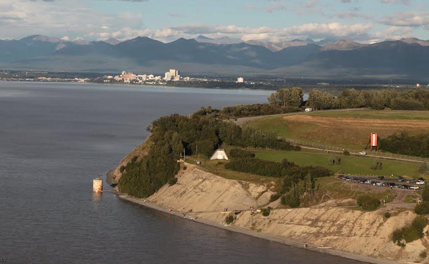
4 Point Woronzof bluff

5 Pt. Woronzof from 1909 to 1954 From 1909 to 1947 the edge of the bluff moved at 2 ft/year

6 Surveying data:

7 Surveying data:
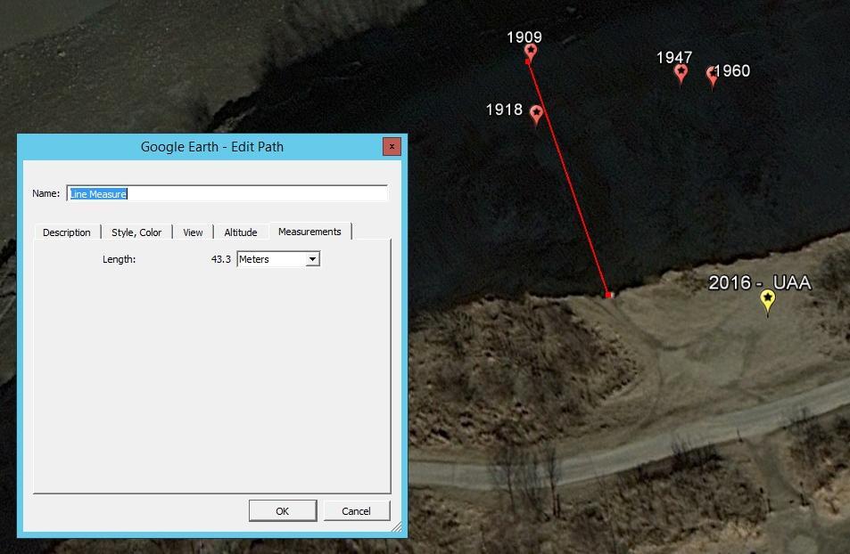
8 1909
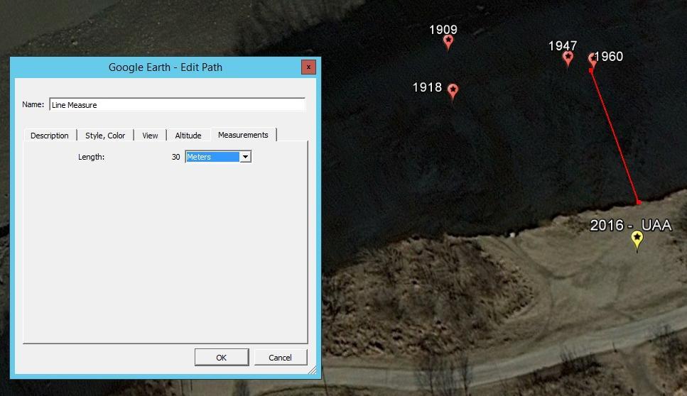
9 1960

10 UAA point 2016


11 UAA point 2016
/5.5 = 0.9m/yr 3ft/yr")
12 From 2011 to 2016 Distance from UAA point to the edge April 2011: 8.5m October 2016: 3.65m Time difference 66 months = 5.5 years Erosion rate ( )/5.5 = 0.9m/yr 3ft/yr

13 Concrete blocks slide from the top of the bluff 135 ft elevation 1/24/12

14 Concrete blocks
15 PHOTOGRAMMETRY AND STRUCTURE FROM MOTION (SFM)
16 An old task: 3D model from multiple pictures


17 A new tool: Structure from Motion (SFM) Automatically generated models Measurable in 3D Any object, any size
18 SFM is based on classical photogrammetric concepts: collinearity Z Y S X Z m o Y M X
19 SFM is based on classical photogrammetric concepts: co-planarity A z a 1 Z x z a 2 Ground coordinate system Y X x
20 COASTAL BLUFF EROSION
21 Bluff erosion and tides Profile following a high tide High tide Low tide

22 Bluff erosion and tides Water digs into the bluff toe at high tides

23 Bluff erosion: weathering and tides Weathering only Weathering + tides Sea level at high tides Base of the bluff above sea level, ft Sea level at low tides

24 Combined forces of Moon and Sun: tidal variations Spring tides: highest high tides Neap tides: lowest high tides Base of the bluff above sea level ft
25 Goals Create 3D base model for monitoring of bluff erosion Evaluate bluff stability at a very high temporal resolution Estimate weathering and tidal contribution into bluff erosion
26 FIELD WORK
27 Data collection Take pictures of the bluff from the beach during the low tide Equipment DSLR camera Canon EOS 5D Mark II with Zeiss 50mm lens RTK surveying
28 Field work specs Height of the bluff: 40 m (120 ft) Length of the bluff: 830 m (2,750 ft) Number of photos (per day): 220 Photo base: 4 m (12 ft) Distance from camera to the bluff toe: 35 m (115 ft) Ground resolution: 7.5 mm (1/3 )
29 Ground control Not available on the bluff surface Not available on the beach only concrete blocks Not available on the edge of the bluff Possible on the top (plateau) but not visible from the beach Solution: camera location with RTK
30 DATA PROCESSING
31 Data processing workflow Surveying data adjustment OPUS 3D modeling Photoscan (Structure from Motion, SFM) Cloud-to-cloud analysis CloudCompare Multi-temporal surface analysis Hupercube

32 Tie points from SFM Each point has been identified in more than 10 overlapping photos
33 3D model: 97,209,269 points 180 ft

34 1/24/12 3D model: 3,050 points per sq.ft

35 Source image
36 Camera positional accuracy X error (cm) Y error (cm) Z error (cm) XY error (cm) Total error (cm)

37 Ground control points accuracy


38 Check points: concrete blocks


39 Check points: bluff features
40 CLOUD-TO-CLOUD

41 Cloud-to-cloud registration
 X (easting) Y")
42 3D movement components Z (elevation) X (easting) Y (northing)
43 Surface movement: 3D components Day 1 Z (elevation) dz Profile following a high tide dx=0 dy Day 2 Y (northing) High tide Low tide

44 Surface movement: dx

45 Surface movement: dy

46 Surface movement: dz

47 Surface movement: dx+dy+dz
48 BLUFF DYNAMICS

49 High tides above the base of bluff in 2016 May: 7 days June-August: tides are below the base of the bluff September: tides were not high as predicted October: 8 days November: 7 days
50 Mapping the bluff dynamics Reconstruct 3D surface for each day of observations Align surfaces Chose first surface as a base Sequentially subtract surfaces Visualize differences Calculate gain and loss in volume

51 Illustration: bluff segment 200m

52 October 15 vs October 13: 2 days No high tide yet

53 October 16 vs October 13: 3 days High tide in
54 October 17 vs October 13: 4 days High tide in

55 October 18 vs October 13: 5 days High tide in
56 October 19 vs October 13: 6 days High tide is getting lower
57 October 20 vs October 13: 7 days High tide is even lower

58 Three weeks later: November 12 No tides, just weathering


59 November 18 vs October 13: 35 days Two high tide periods + weathering Surface difference in meters

60 Volume balance 10/20 minus 10/13 11/12 minus 10/20 11/18 minus 11/12 11/18 minus 10/13 high tides in weathering between high tides in two high tides and October high tides November weathering Loss, m Gain, m Net, m Net, yd Trucks Bluff segment Length 502 ft Height 138 ft Surface area 69,498 sq.ft 6,456 sq.m
61 FURTHER STUDY
62 Terrestrial SFM Spring 2017 Complete one year cycle Build an annual dynamic 3D model Explore seasonal phases of erosion Define slop stability areas
63 Weather data analysis Correlate bluff dynamics with air temperature precipitation wind speed wind direction Evaluate wave height and possibly shallow water wave power/energy
64 Weather data analysis Wind speed and direction: May May Average wind speed May Wind direction
65 Weather data analysis Wind speed and direction: October 2016 October Average wind speed October Wind direction
66 Weather data analysis Wind speed vs wind direction October Wind speed vs wind direction May Wind speed vs wind direction
67 Geological analysis Map the geology of the bluff (transect) Correlate bluff stability zones with geology

68 Historical 3D data: aerial photography (2010)
69 Oblique aerial photography (2010) Height of the bluff: 40 m (120 ft) Length of the bluff : ~600 m (fragment) Number of photos: 5 Photo base: m Distance from camera to the bluff: 390 m Ground resolution: 5 cm (2 )

70 LiDAR 2015

71 Historical aerial photographs
72 Summary The bluff moves! Hi-precision 3D base model has been created to monitor bluff erosion A map of bluff stability zones has been created at a very high spatial resolution Weathering and tidal contribution into bluff erosion have been evaluated and mapped
73 Acknowledgements Prof. Tom Ravens, UAA Dr. Jon Zufelt, HDR Prof. Jeff Hollingsworth, UAA Aleksey Voloshin, UAA Geomatics student
Town of Duck, North Carolina
 Tracking No. 00.00.2010 Erosion Mitigation And Shoreline Management Feasibility Study Town of Duck, North Carolina Coastal Planning & Engineering of North Carolina August 15, 2012 Tom Jarrett Robert Neal
COASTAL EROSION. 1 Getting Oriented
 COASTAL EROSION Many people dream of building their home on the California Coastline with its picturesque vistas of the setting sun and the gentle sounds of waves breaking. However, these waves are not
Sussex County, DE Preliminary Study Overview
 Sussex County, DE Preliminary Study Overview Coastal study scope: 102 miles of entire County shoreline Revised 102 panels for coastal study Riverine study scope: 14 streams, 67.1 miles, within the Nanticoke
Beach Profiles. Topics. Module 9b Beach Profiles and Crossshore Sediment Transport 3/23/2016. CE A676 Coastal Engineering
 Beach Profiles AND CROSS-SHORE TRANSPORT Orson P. Smith, PE, Ph.D., Professor Emeritus Topics Features of beach and nearshore profiles Equilibrium profiles Cross-shore transport References Text (Sorensen)
INTRODUCTION TO COASTAL ENGINEERING
 The University of the West Indies Organization of American States PROFESSIONAL DEVELOPMENT PROGRAMME: COASTAL INFRASTRUCTURE DESIGN, CONSTRUCTION AND MAINTENANCE A COURSE IN COASTAL DEFENSE SYSTEMS I CHAPTER
St. Louis County, MN Coastal Hazard Analysis Flood Risk Review Meeting. May 2, 2018
 St. Louis County, MN Coastal Hazard Analysis Flood Risk Review Meeting May 2, 2018 Agenda Introductions Coastal Flood Risk Study and Mapping Program Current Status Technical Overview of Study and Mapping
Bayfield & Ashland Counties, WI Coastal Hazard Analysis Flood Risk Review Meeting. June 05, 2018
 Bayfield & Ashland Counties, WI Coastal Hazard Analysis Flood Risk Review Meeting June 05, 2018 Agenda Introductions Coastal Flood Risk Study and Mapping Program Current Status Technical Overview of Study
New Jersey Coastal Zone Overview. The New Jersey Beach Profile Network (NJBPN) 3 Dimensional Assessments. Quantifying Shoreline Migration
 3 Dimensional Assessments. Quantifying Shoreline Migration") New Jersey Coastal Zone Overview The New Jersey Beach Profile Network (NJBPN) Objectives Profile Locations Data Collection Analyzing NJBPN Data Examples 3 Dimensional Assessments Methodology Examples Quantifying
New Jersey Coastal Zone Overview The New Jersey Beach Profile Network (NJBPN) Objectives Profile Locations Data Collection Analyzing NJBPN Data Examples 3 Dimensional Assessments Methodology Examples Quantifying
UPPER BEACH REPLENISHMENT PROJECT RELATED
 ASSESSMENT OF SAND VOLUME LOSS at the TOWNSHIP of UPPER BEACH REPLENISHMENT PROJECT RELATED to the LANDFALL OF HURRICANE SANDY - PURSUANT TO NJ-DR 4086 This assessment is in response to Hurricane Sandy
4/20/17. #32 - Coastal Erosion Case Histories - Lake Michigan
 Writing Assignment Due Monday by 11:59 pm #32 - Coastal Erosion Case Histories - Lake Michigan See main class web pages for detailed instructions Submit papers Illinois Compass No copying: Compass will
Volume and Shoreline Changes along Pinellas County Beaches during Tropical Storm Debby
 Volume and Shoreline Changes along Pinellas County Beaches during Tropical Storm Debby Ping Wang and Tiffany M. Roberts Coastal Research Laboratory University of South Florida July 24, 2012 Introduction
Tracking Marsh Elevation and Water Levels in Elkhorn Slough January 2017
 Tracking Marsh Elevation and Water Levels in Elkhorn Slough January 2017 1931 Charlie Endris GIS Specialist Elkhorn Slough NERR Elkhorn Slough Foundation Central Coast Wetlands Group 2015 Questions Are
Door County, WI Coastal Hazard Analysis Flood Risk Review Meeting. August 21, 2017
 Door County, WI Coastal Hazard Analysis Flood Risk Review Meeting August 21, 2017 Agenda Introductions Coastal Flood Risk Study and Mapping Program Current Status Technical Overview of Study and Mapping
Airborne Remote Sensing of Surface and Internal Wave Processes on the Inner Shelf
 Airborne Remote Sensing of Surface and Internal Wave Processes on the Inner Shelf Ken Melville, Luc Lenain Scripps Institution of Oceanography North Wind/Wave NDBC Station 42040 29.212 N 88.207 W 19 Oct
The Composition of Seawater
 The Composition of Seawater Salinity Salinity is the total amount of solid material dissolved in water. Most of the salt in seawater is sodium chloride, common table salt. Element Percent Element Percent
page - Laboratory Exercise #5 Shoreline Processes
 page - Laboratory Exercise #5 Shoreline Processes Section A Shoreline Processes: Overview of Waves The ocean s surface is influenced by three types of motion (waves, tides and surface currents). Shorelines
3.6 Magnetic surveys. Sampling Time variations Gradiometers Processing. Sampling
 3.6 Magnetic surveys Sampling Time variations Gradiometers Processing Sampling Magnetic surveys can be taken along profiles or, more often, on a grid. The data for a grid is usually taken with fairly frequent
Theory and Application Introductory Oceanography Ray Rector: Instructor
 OCEAN TIDES Theory and Application Introductory Oceanography Ray Rector: Instructor Tidal Concepts Tides are extremely swift, very long-wavelength, shallow-water waves Tides are periodic short-term changes
Unit VI Detecting Coastal Change with Lasers. Modern Coastal Studies
 Unit VI Detecting Coastal Change with Lasers On the cutting edge Barrier Islands provide natural protection against the destructive wind, waves, and tides that wash the shores of coastal communities. As
Activity #1: The Dynamic Beach
 Activity #1: The Dynamic Beach Beach Profiling By Betsy Sheffield, COASTeam Program, College of Charleston, Charleston, SC Subjects: Science, Math Skills: Analysis, description, listing, research, small
Baraga County, MI Coastal Hazard Analysis Flood Risk Review Meeting. July 12, 2018
 Baraga County, MI Coastal Hazard Analysis Flood Risk Review Meeting July 12, 2018 Agenda Introductions Coastal Flood Risk Study and Mapping Program Current Status Technical Overview of Study and Mapping
yarn (1-2 meters) tape sticky notes slinky short piece of yarn or ribbon calculator stopwatch
 tape sticky notes slinky short piece of yarn or ribbon calculator stopwatch") Objective: I can identify the properties of waves and relate them to the energy they carry. Materials: yarn (1-2 meters) tape sticky notes slinky short piece of yarn or ribbon calculator stopwatch Demonstration:
Objective: I can identify the properties of waves and relate them to the energy they carry. Materials: yarn (1-2 meters) tape sticky notes slinky short piece of yarn or ribbon calculator stopwatch Demonstration:
Boothbay Harbor Rotary Club May 12, 2016
 Mapping Potential Sea Level Rise and Storm Surge in Boothbay Harbor, ME Boothbay Harbor Rotary Club May 12, 2016 Peter A. Slovinsky, Marine Geologist Maine Geological Survey S.M. Dickson, MGS Quickly,
THE CHALLENGES OF A LARGE-AREA BATHYMETRIC SURVEY
 THE CHALLENGES OF A LARGE-AREA BATHYMETRIC SURVEY Agenda: - Introduction - Tender - Project Planning - Survey - Processing - Delivery - Conclusion 2 Introduction We know less of the oceans at our feet,
Trial of a process to estimate depth of cover on buried pipelines
 Trial of a process to estimate depth of cover on buried pipelines Daniel Finley (CEng MIMechE) Principal Engineer ROSEN Group Third Party Interference Protection against 3rd party interference can be an
Chapter. The Dynamic Ocean
 Chapter The Dynamic Ocean An ocean current is the mass of ocean water that flows from one place to another. 16.1 The Composition of Seawater Surface Circulation Surface Currents Surface currents are movements
April 7, Prepared for: The Caribbean Disaster Emergency Response Agency Prepared by: CEAC Solutions Co. Ltd.
 April 7, 2006 Prepared for: The Caribbean Disaster Emergency Response Agency Prepared by: Introduction CEAC Solutions Co. Ltd was commissioned in May 2005 to prepare coastal beach erosion hazard maps for
Bay County, MI Coastal Hazard Analysis Flood Risk Review Meeting. May 14, 2018
 Bay County, MI Coastal Hazard Analysis Flood Risk Review Meeting May 14, 2018 Agenda Introductions Coastal Flood Risk Study and Mapping Program Current Status Technical Overview of Study and Mapping Floodplain
Pathways Interns: Annika O Dea, Ian Conery, Andrea Albright
 1 REMOTE SENSING OF COASTAL MORPHODYNAMICS 237 237 237 217 217 217 2 2 2 8 119 27 252 174.59 255 255 255 163 163 163 131 132 122 239 65 53 11 135 12 112 92 56 62 12 13 12 56 48 13 12 111 Kate Brodie Brittany
CHAPTER 281 INFLUENCE OF NEARSHORE HARDBOTTOM ON REGIONAL SEDIMENT TRANSPORT
 CHAPTER 281 INFLUENCE OF NEARSHORE HARDBOTTOM ON REGIONAL SEDIMENT TRANSPORT Paul C.-P. Lin, Ph.D., P.E. 1 and R. Harvey Sasso, P.E. 2 ABSTRACT The influence of nearshore hardbottom on longshore and cross-shore
Impact of Dredging the Lower Narrow River on Circulation and Flushing
 Impact of Dredging the Lower Narrow River on Circulation and Flushing Craig Swanson Ph.D. Swanson Environmental Alex Shaw Ocean Engineering, URI Prof. Malcolm L. Spaulding Ocean Engineering, URI 29 January
TIDES. Theory and Application
 TIDES Theory and Application Tidal Concepts Tides are extremely swift, very long-wavelength, shallow-water waves Tides are periodic short-term changes in sea level at a particular place caused by the gravitational
Southwest Washington Littoral Drift Restoration Project: Design, Construction, and Monitoring
 Southwest Washington Littoral Drift Restoration Project: Design, Construction, and Monitoring J Jessica i St Stokke kk USACE Portland District October 28, 2010 WEDA Pacific Meeting Monterey, CA US Army
Town of Duck, North Carolina
 Tracking No. 00.00.2010 Erosion Mitigation And Shoreline Management Feasibility Study Town of Duck, North Carolina Coastal Planning & Engineering of North Carolina February 28, 2013 Ken Willson 1 Tracking
Small Footprint Topo-Bathymetric LiDAR
 May 8, 2013 Small Footprint Topo-Bathymetric LiDAR PNAMP Remote Sensing Forum Russ Faux, Co-CEO, WSI Amar Nayegandhi, Manager of Elevation Technologies, Dewberry Colin Cooper, Senior Analyst, WSI Watershed
Mouth of the Columbia River Jetties Three-Phase Construction Plan
 Mouth of the Columbia River Jetties Three-Phase Construction Plan Project Overview October 9, 2012 US Army Corps of Engineers MCR Jetties Major Rehabilitation Sand Island pile dikes 1930-1935 Columbia
STATUS REPORT FOR THE SUBMERGED REEF BALL TM ARTIFICIAL REEF SUBMERGED BREAKWATER BEACH STABILIZATION PROJECT FOR THE GRAND CAYMAN MARRIOTT HOTEL
 August 23 STATUS REPORT FOR THE SUBMERGED REEF BALL TM ARTIFICIAL REEF SUBMERGED BREAKWATER BEACH STABILIZATION PROJECT FOR THE GRAND CAYMAN MARRIOTT HOTEL performed by Lee E. Harris, Ph.D., P.E. Consulting
New Vertical Datum for the Dead Sea Works, Israel 2008
 Dan SHARNI, Israel Key words: orthometric correction, geoid undulation SUMMARY The Survey of Israel (SOI) funded an applied research project, to establish Improved Geoid for the South Dead Sea, 2008. The
Overview and preview. I. Tides as Waves (really really big) What are the Forces driving these waves? II: Into make-believe.
 What are the Forces driving these waves? II: Into make-believe.") The Tides Overview and preview I. Tides as Waves (really really big) What are the Forces driving these waves? II: Into make-believe. Idealized world: no land, deep water, no friction.no problems. Effects
The Tides Overview and preview I. Tides as Waves (really really big) What are the Forces driving these waves? II: Into make-believe. Idealized world: no land, deep water, no friction.no problems. Effects
Spatial Methods for Road Course Measurement
 Page 1 of 10 CurtinSearch Curtin Site Index Contact Details Links LASCAN Spatial Sciences WA Centre for Geodesy COURSE MEASUREMENT This page is a summary of results of some of the research we have recently
CHAPTER 8 ASSESSMENT OF COASTAL VULNERABILITY INDEX
 124 CHAPTER 8 ASSESSMENT OF COASTAL VULNERABILITY INDEX 8.1 INTRODUCTION In order to assess the vulnerability of the shoreline considered under this study against the changing environmental conditions,
Modern and Ancient Tides
 Modern and Ancient Tides A lesson plan to be used in conjunction with the Modern and Ancient Tides poster and booklet available from the Indiana Geological Survey. Overview Students will discover how tides
Citrus, Hernando, and Pasco Coastal Hazard Analysis. Flood Risk Review Meeting Citrus, Hernando, and Pasco Counties, Florida December 14, 2017
 Citrus, Hernando, and Pasco Coastal Hazard Analysis Flood Risk Review Meeting Citrus, Hernando, and Pasco Counties, Florida December 14, 2017 Introductions Risk MAP Project Team FEMA Region IV RAMPP (study
SURFACE CURRENTS AND TIDES
 NAME SURFACE CURRENTS AND TIDES I. Origin of surface currents Surface currents arise due to the interaction of the prevailing wis a the ocean surface. Hence the surface wi pattern (Figure 1) plays a key
R E M I N D E R S. v Two required essays are due by April 9, v Extra Credit: Think Geographically Essays from any five of the textbook s
 R E M I N D E R S v Two required essays are due by April 9, 2019. Ø A third may be used for extra credit in place of a Think Geographically essay. ESSAY TOPICS (choose any two): Contributions of a noted
Coastal Inundation. An Overview for TCDC
 Coastal Inundation An Overview for TCDC Rick Liefting Team Leader Regional Hazards and Environmental Compliance Integrated Catchment Management Waikato Regional Council Photo: Sugar Loaf Wharf, Coromandel.
Digital Elevation Models
 Digital Elevation Models National Elevation Dataset 14-Oct-14 GEO327G/386G, UT Austin 1 Data Sets US DEM series 7.5, 30, 1 o for conterminous US 7.5, 15 for Alaska US National Elevation Data (NED) GTOPO30
Challenges in determining water surface in airborne LiDAR topobathymetry. Amar Nayegandhi, Dewberry 15 th Annual JALBTCX Workshop, June 11 th 2014
 Challenges in determining water surface in airborne LiDAR topobathymetry Amar Nayegandhi, Dewberry 15 th Annual JALBTCX Workshop, June 11 th 2014 Why topobathy LiDAR? Complements acoustic (multi-beam sonar)
FEMA Region V. Great Lakes Coastal Flood Study. Pilot Study Webinar. Berrien County, Michigan. February 26, 2014
 FEMA Region V Great Lakes Coastal Flood Study Pilot Study Webinar Berrien County, Michigan February 26, 2014 2 Pilot Study Webinar Agenda Great Lakes Coastal Flood Study Background Demonstration Project
PACIFIC NORTHWEST TEST OF A HYDROGRAPHIC AIRBORNE LASER SCANNER
 PACIFIC NORTHWEST TEST OF A HYDROGRAPHIC AIRBORNE LASER SCANNER Green LiDAR Workshop June 3 7, 2012 Russell Faux, Principal Watershed Sciences, Inc. 517 SW 2 nd Street, Suite 400 Corvallis, OR 97333 541
Data Collection and Processing: Elwha Estuary Survey, February 2013
 Data Collection and Processing: Elwha Estuary Survey, February 2013 Ian Miller, WA Sea Grant Olympic Peninsula Field Office, 1502 E. Lauridsen Blvd #82, Port Angeles, WA 98362 immiller@u.washington.edu
Shorelines Earth - Chapter 20 Stan Hatfield Southwestern Illinois College
 Shorelines Earth - Chapter 20 Stan Hatfield Southwestern Illinois College The Shoreline A Dynamic Interface The shoreline is a dynamic interface (common boundary) among air, land, and the ocean. The shoreline
Project Incorporation of Sea Level Rise City of Newport Beach Approach for Balboa Islands, City of Newport Beach, California
 Project Incorporation of Sea Level Rise City of Newport Beach Approach for Balboa Islands, City of Newport Beach, California Ying Poon, Everest International Consultants, Inc. CMANC Annual Winter Meeting
SAN DIEGUITO WETLANDS RESTORATION PROJECT 08 JANUARY 2018 BEACH PROFILES CITY OF DEL MAR, CALIFORNIA. Data Report
 SAN DIEGUITO WETLANDS RESTORATION PROJECT 08 JANUARY 2018 BEACH PROFILES CITY OF DEL MAR, CALIFORNIA Data Report Prepared by Coastal Environments, Inc. 2166 Avenida de la Playa, Suite E La Jolla, CA 92037
How Much Land Has Been Lost?
 Land and Water Interactions Activity 2 of Two We might wonder exactly how much land is lost with erosion. It is easier to see surface changes than to perceive actual amounts in terms of volume. Analytical
Ongoing Research at the USACE Field Research Facility Jeff Waters, PhD Chief, Coastal Observations & Analysis Branch Coastal & Hydraulics Lab
 Ongoing Research at the USACE Field Research Facility Jeff Waters, PhD Chief, Coastal Observations & Analysis Branch Coastal & Hydraulics Lab Coastal and Hydraulics Laboratory Who We Are CHL is the only
COASTAL MORPHODYNAMICS
 COASTAL MORPHODYNAMICS PATRICIA CHARDÓN-MALDONADO, PHD, EIT Miguel Canals, Jack A. Puleo, Alec Torres-Freyermuth & Jens Figlus March 9, 2017 OUTLINE INTRODUCTION Meteorological Phenomena Forcing Conditions
Among the numerous reasons to develop an understanding of LST are:
 Longshore Sediment Transport Among the numerous reasons to develop an understanding of LST are: Process by which the products of terrestrial erosion (riverine sediments, sea cliff failures, etc.) are removed
Beach Profiles: Monitoring Sea Level Rise. Student Activity Sheet. Name Date Class
 Beach Profiles: Monitoring Sea Level Rise Student Activity Sheet Name Date Class A shoreline is the area where the water and land meet. This is where we find beach: areas where sediments (sand or other
GOLFZON REAL has superior graphic features
 GOLFZON REAL has superior graphic features and its virtual courses present unmatched reality Virtual courses in GOLFZON REAL are designed from aerial photographs and 3-dimensional photography technology.
Investigation of the Impact of Beach Raking on Beach Accretion/Erosion: West End Beaches of Galveston Island, Texas 2007/ 2008
 Investigation of the Impact of Beach Raking on Beach Accretion/Erosion: West End Beaches of Galveston Island, Texas 2007/ 2008 By Robert Webster 1, Timothy Dellepenna Ph.D. 1, 1 Texas A&M at Galveston
Large-scale Field Test
 Vaskinn 1 Large-scale Field Test Kjetil Arne Vaskinn kav@trh.statkraftgroner.no Statkraft Grøner AS SUMMARY The objective the controlled failure of large-scale embankment is to monitor and record the failure
Determination of Survey Boat Heave Motion with the Use of RTS Technique
 Environmental Engineering 10th International Conference Vilnius Gediminas Technical University Lithuania, 27 28 April 2017 http://enviro.vgtu.lt eissn 2029-7092 / eisbn 978-609-476-044-0 Article ID: enviro.2017.229
New Stuyahok-Ekwok Intertie Route Wind Power Site Options
 New Stuyahok-Ekwok Intertie Route Wind Power Site Options November 30, 2015 Douglas Vaught, P.E. V3 Energy, LLC Anchorage, Alaska www.v3energy.com New Stuyahok-Ekwok Intertie Wind Power Site Options Page
USE OF SEGMENTED OFFSHORE BREAKWATERS FOR BEACH EROSION CONTROL
 .. CETN-III-22 4/84 PURPOSE: USE OF SEGMENTED OFFSHORE BREAKWATERS FOR BEACH EROSION CONTROL To provide information on the functional application of and general design considerations for using offshore
Unit 4 Lesson 3 Earth s Tides. Copyright Houghton Mifflin Harcourt Publishing Company
 Florida Benchmarks SC.8.N.1.1 Define a problem from the eighth grade curriculum using appropriate reference materials to support scientific understanding, plan and carry out scientific investigations of
EROSION MECHANICS OF A CARBONATE- TOMBOLO BEACH IN MIYAKOJIMA ISLAND, OKINAWA PREFECTURE, JAPAN.
 EROSION MECHANICS OF A CARBONATE- TOMBOLO BEACH IN MIYAKOJIMA ISLAND, OKINAWA PREFECTURE, JAPAN. Ryuichiro NISHI 1, Takaaki UDA 2, Akio KIKUCHI 3 and Kou FURUIKE 4 1) Associate Prof. Dept. of Ocean Civil
/50. Physical Geology Shorelines
 Physical Geology Shorelines Multiple Guess: (You know the drill 2 points each) 1. The path of movement of a water particle in a wave at sea is 1. circular 2. horizontal 3. vertical 4. elliptical 5. none
MAR 110 LECTURE #22 Standing Waves and Tides
 27 October 2007 MAR110_Lec22_standing Waves_tides_27oct07.doc 1 MAR 110 LECTURE #22 Standing Waves and Tides Coastal Zone Beach Profile Figure 22.1 Beach Profile Summer Onshore Sand Transport Breaking
Figure 1, Chart showing the location of the Breach at Old Inlet and sensors deployed in Great South Bay.
 The Impact on Great South Bay of the Breach at Old Inlet Charles N. Flagg and Roger Flood School of Marine and Atmospheric Sciences, Stony Brook University The Great South Bay project (http://po.msrc.sunysb.edu/gsb/)
CROSS-SHORE SEDIMENT PROCESSES
 The University of the West Indies Organization of American States PROFESSIONAL DEVELOPMENT PROGRAMME: COASTAL INFRASTRUCTURE DESIGN, CONSTRUCTION AND MAINTENANCE A COURSE IN COASTAL DEFENSE SYSTEMS I CHAPTER
Estimating Beach Volume Change as a function of Beach Profile Spacing
 Estimating Beach Volume Change as a function of Beach Profile Spacing Kevin R. Bodge, Ph.D., P.E. William Reilly, P.E. and Patrick Snyder, P.E. Steve Howard, P.E. Bill Hobensack, P.E. Chris Creed, P.E.
AN EXPERIMENTAL INVESTIGATION OF SPILLING BREAKERS
 AN EXPERIMENTAL INVESTIGATION OF SPILLING BREAKERS Prof. James H. Duncan Department of Mechanical Engineering University of Maryland College Park, Maryland 20742-3035 phone: (301) 405-5260, fax: (301)
APPROACH RUN VELOCITIES OF FEMALE POLE VAULTERS
 APPROACH RUN VELOCITIES OF FEMALE POLE VAULTERS Peter M. McGinnis, Physical Education Department, SUNY College at Cortland, Cortland, New York INTRODUCTION Running speed is an important determinant of
Drift Characteristics of Paroscientific pressure sensors
 Drift Characteristics of Paroscientific pressure sensors by Randolph Watts, Maureen Kennelly, Karen Tracey, and Kathleen Donohue (University of Rhode Island) PIES + current meter & CPIES arrays Paroscientific
A real time vessel air gap monitoring system
 Journal of Physics: Conference Series A real time vessel air gap monitoring system To cite this article: D McStay and K Thabeth 2009 J. Phys.: Conf. Ser. 178 012038 View the article online for updates
2016 NC Coastal Local Governments Annual Meeting
 2016 NC Coastal Local Governments Annual Meeting Coastal Flood Study Modeling and Mapping 101 April 21, 2016 Tom Langan, PE, CFM Engineering Supervisor NCEM Floodplain Mapping Program FEMA Coastal Flood
Analysis of Wave Predictions from the Coastal Model Test Bed using cbathy
 Analysis of Wave Predictions from the Coastal Model Test Bed using cbathy Spicer Bak, Ty Hesser, Jane Smith U.S. Army Engineer Research & Development Center Duck, NC Coastal Model Test Bed Purpose: Automated
Assateague Island National Seashore North End Restoration Project Timeline
 Assateague Island National Seashore North End Restoration Project Timeline Date Event Some information provided in the Project Introduction document. Detailed events are available in a timeline compiled
Cycling Volume Estimation Methods for Safety Analysis
 Cycling Volume Estimation Methods for Safety Analysis XI ICTCT extra Workshop in Vancouver, Canada Session: Methods and Simulation Date: March, 01 The Highway Safety Manual (HSM) documents many safety
Equilibrium Model of Tides
 Tides Outline Equilibrium Theory of Tides diurnal, semidiurnal and mixed semidiurnal tides spring and neap tides Dynamic Theory of Tides rotary tidal motion larger tidal ranges in coastal versus open-ocean
Multibeam and Laser: Combined High Resolution. Hydrographic Surveying for Civil Engineering Project Support
 Multibeam and Laser: Combined High Resolution Hydrographic Surveying for Civil Engineering Project Support John Dillon-Leetch,Port of London Authority Duncan Mallace, NetSurvey, UK Overview Introduction
Mechanisms and Characteristics of High-Speed Reef Rip Current
 Mechanisms and Characteristics of High-Speed Reef Rip Current Ryuichiro Nishi, Mario P. de Leon, Kouji Horinouchi,Akira Ohtani, Nicholas C. Kraus, and Julianti K. Manu Many people utilize beaches, but
ST. JOSEPH PENINSULA, GULF COUNTY, FLORIDA Beach Re-Nourishment and Environmental Enhancement Project RECOMMENDATIONS
 ST. JOSEPH PENINSULA, GULF COUNTY, FLORIDA Beach Re-Nourishment and Environmental Enhancement Project RECOMMENDATIONS January 23, 2018 543 Harbor Boulevard, Suite 204 Destin, Florida 32541 850.654.1555
Affects of Tides on Lateral Coastal Access at. Las Varas Ranch. Gaviota, California. Photos Courtesy of California Coastal Records Project
 Affects of Tides on Lateral Coastal Access at Las Varas Ranch Gaviota, California Photos Courtesy of California Coastal Records Project September 18, 2014 Santa Barbara County Trails Council 1 As part
SUNY Canton Wind Energy System
 SUNY Canton Wind Energy System Visual Assessment June 2013 Prepared for the New York Power Authority and the State University of New York at Canton VISUAL ASSESSMENT / PHOTOMONTAGE One part of a wind project,
Executive Summary of Accuracy for WINDCUBE 200S
 Executive Summary of Accuracy for WINDCUBE 200S The potential of offshore wind energy has gained significant interest due to consistent and strong winds, resulting in very high capacity factors compared
Assessing Mechanisms and Rates of Levee Erosion in the Sacramento-San Joaquin Delta
 Assessing Mechanisms and Rates of Levee Erosion in the Sacramento-San Joaquin Delta Douglas Sherman, Texas A&M University Bernard Bauer, University of British Columbia, Okanogan Mark Lorang, University
The Impact on Great South Bay of the Breach at Old Inlet Charles N. Flagg School of Marine and Atmospheric Sciences, Stony Brook University
 The Impact on Great South Bay of the Breach at Old Inlet Charles N. Flagg School of Marine and Atmospheric Sciences, Stony Brook University This is the sixth in a series of reports describing the evolution
The Cumulative Impacts of Shoreline Armoring on Forage Fish Spawning Habitat in San Juan County, Washington
 Western Washington University Western CEDAR Salish Sea Ecosystem Conference 2014 Salish Sea Ecosystem Conference (Seattle, Wash.) May 1st, 1:30 PM - 3:00 PM The Cumulative Impacts of Shoreline Armoring
HIGH VOLUME SEDIMENT TRANSPORT AND ITS IMPLICATIONS FOR RECREATIONAL BEACH RISK
 HIGH VOLUME SEDIMENT TRANSPORT AND ITS IMPLICATIONS FOR RECREATIONAL BEACH RISK Tim Scott 1, Paul Russell 1, Gerhard Masselink 1, Adam Wooler 2 and Andrew Short 3 In a coastal region where there are large
WATERWAYS AND HARBORS DIVISION Proceedings of the American Society of Civil Engineers. EQUILIBRIUM FLOW AREAS OF INLETS ON SANDY COASTS a
 6405 February, 1969 WWl J oumal of the WATERWAYS AND HARBORS DIVISION Proceedings of the American Society of Civil Engineers EQUILIBRIUM FLOW AREAS OF INLETS ON SANDY COASTS a By Morrough P. O'Brien,!
FieldStrength. Using MotionTrak for motion correction in body imaging. Application tips
 FieldStrength Publication for the Philips MRI Community Issue 35 September / October 2008 Using MotionTrak for motion correction in body imaging Application tips This article is part of Field Strength
Bathymetry Data Collection for Subaqueous Soil Mapping. Maggie Payne 2 nd National Workshop on Subaqueous Soils Rhode Island August 9-12, 2010
 Bathymetry Data Collection for Subaqueous Soil Mapping Maggie Payne 2 nd National Workshop on Subaqueous Soils Rhode Island August 9-12, 2010 Overview of Method Collect tide data Collect bathymetry data
Beach profile surveys and morphological change, Otago Harbour entrance to Karitane May 2014 to June 2015
 Beach profile surveys and morphological change, Otago Harbour entrance to Karitane May 2014 to June 2015 Prepared for Port Otago Ltd Martin Single September 2015 Shore Processes and Management Ltd Contact
Accuracy and Precision of High-Speed Field Measurements of Pavement Surface Rutting and Cracking
 Accuracy and Precision of High-Speed Field Measurements of Pavement Surface Rutting and Cracking Pedro A. Serigos, MSE, MSStat - serigosp@utexas.edu Jorge A. Prozzi, PhD Andre de Fortier Smit, PhD Mike
Dune Monitoring Data Update Summary: 2013
 Dune Monitoring Data Update Summary: 13 Shoreline Studies Program Virginia Institute of Marine Science College of William & Mary Gloucester Point, Virginia September 13 Dune Monitoring Data Update Summary:
RI Regulatory Setbacks & Buffers: Coastal Management Issues
 RI Regulatory Setbacks & Buffers: Coastal Management Issues New England Onsite Wastewater Training Program @ URI OWT 155 - November 29, 2012 James Boyd - Coastal Policy Analyst Photo: October 30, 2012
REVISION #1 and DATE OF REVISION (07/01/08) Improving Accuracy and Statistical Reliability of Shoreline Position and Change Rate Estimates
 Improving Accuracy and Statistical Reliability of Shoreline Position and Change Rate Estimates") REVISION #1 and DATE OF REVISION (07/01/08) Improving Accuracy and Statistical Reliability of Shoreline Position and Change Rate Estimates (Running Head: shoreline position and change rate accuracy) Peter
REVISION #1 and DATE OF REVISION (07/01/08) Improving Accuracy and Statistical Reliability of Shoreline Position and Change Rate Estimates (Running Head: shoreline position and change rate accuracy) Peter
Understanding the Tsunami Wave
 The First Tsunami attack on Sri Lanka Krakatoa Island 27 th August 1883 Understanding the Tsunami Wave Generation Propagation Nearshore Transformation Shoreline Entry Inland Dissipation 1 Generation and