Airborne Remote Sensing of Surface and Internal Wave Processes on the Inner Shelf
|
|
|
- Augustus Jefferson
- 5 years ago
- Views:
Transcription


1 Airborne Remote Sensing of Surface and Internal Wave Processes on the Inner Shelf Ken Melville, Luc Lenain Scripps Institution of Oceanography North Wind/Wave NDBC Station N W 19 Oct 2011 C 600m Airborne infrared imagery showing a temperature front at the northern Spatial resolution boundary of the loop current 0.25x0.25m
 Surface wave breaking & mixing Langmuir Circulation, turbulence Internal waves, internal tides Surface currents, eddies Instrument")
2 Overview To investigate the role of surface and internal wave processes on the dynamics, transport and mixing in the water column on the inner shelf and their measurement using an airborne platform. Phenomenon/Process Surface waves Sea surface temperature (SST) Surface wave breaking & mixing Langmuir Circulation, turbulence Internal waves, internal tides Surface currents, eddies Instrument Scanning lidars IR camera, radiometer Visible & IR video Visible & IR video, hyperspectral imager Scanning lidars, visible and IR video, hyperspectral imager IR and hyperspectral imagers
 GPS/IMU (NovAtel LN200 SPAN) Power distribution,")
 Scanning")
3 SIO Modular Aerial Sensing System (MASS) Hyperspectral (Specim EagleAISA) GPS/IMU (NovAtel LN200 SPAN) Power distribution, synchronization, data acquisition Operator touchscreen 54 cm 8 Mpx digital color camera Long Wave IR Camera (FLIR SC6000 LWIR) Scanning waveform lidar (RIEGL Q680i)

 Long-wave IR Camera FLIR SC6000 (QWIP) Ocean surface processes, wave kinematics and breaking, frontal processes High-Resolution Video JaiPulnix AB-800CL Ocean surface processes,")
4 SIO Modular Aerial Sensing System (MASS) NDBC Station N W 19 Oct 2011 Example of surface elevation as measured from the MASS during a recent experiment in the Gulf of Mexico, flying above NDBC buoy # (wind~12m/s, Hs = 3.1m) Instrumentation Measurement Spatial resolution 0.25x0.25m Scanning Waveform Lidar Riegl Q680i Surface wave, surface slope, directional wave spectra (vert. accuracy ~2-3cm) Long-wave IR Camera FLIR SC6000 (QWIP) Ocean surface processes, wave kinematics and breaking, frontal processes High-Resolution Video JaiPulnix AB-800CL Ocean surface processes, wave kinematics and breaking, frontal processes Hyperspectral Camera Specim EagleAISA Ocean surface and biogeochemical processes GPS/IMU Novatel SPAN-LN200 Georeferencing, trajectory
 bands during a recent experiment in the Gulf of Mexico.")
5 MASS Example of High-Resolution Measurements of Breaking Waves (IR & Visible) Sample georeferenced images of a breaking wave in the visible and infrared (8-9.2μm) bands during a recent experiment in the Gulf of Mexico. Note that the foam is colder (blue) due to rapid cooling (T water - T atm 8 C) while the active breaker is warmer (red), disrupting the surface skin layer and bringing warmer water from below. Also shown is a perspective view of the sea surface elevation for the same breaking wave color coded for WGS84 height (World Geodetic System 1984 datum). The lower panel shows the profile of the transect A-B marked in the georeferenced visible image.


6 MASS - Wave Observations down to wavelengths of <0.6m over a wide range of conditions
7 MASS Surface wave processes wave breaking Sutherland & Melville (2013): Nondimensional breaking length distribution binned by wave age in color. The solid lines are using IR data from R/P FLIP, the dash-dot lines are using visible imagery from FLIP, and the dashed lines are using airborne visible imagery from Kleiss & Melville (2010).
 on October 30, 2011, 10hr prior to the airborne survey conducted the same day.")

8 MASS Characterization of surface kinematics from airborne thermal imagery Sea surface temperature estimated from TERRA level 3 daily product ( C) on October 30, 2011, 10hr prior to the airborne survey conducted the same day. The flight track is shown in blue. The average surface velocities derived from the thermal imagery are shown as vectors along the flight track (red, positive easterly velocity, black, positive westerly velocity). Note the sharp change in surface velocities as the aircraft went across the LC.
9 Wave Enhancement at SST Front Northern edge of the LC (left) Sea surface temperature imagery of the northern edge of the Gulf of Mexico Loop Current on October (right) Evolution of the omnidirectional wavenumber spectrum as the aircraft flew across the Loop Current. The color scale represents the average SST over the length of the wave record (4 km) used in the spectral analysis, also shown as a function of latitude in the upper panel. Note the wave enhancement going into the LC
10 SSHA from Airborne and Satellite Altimetry ssha ssh mean _ sea _ surface lidar lidar Satellite ocean _ tides Tidal_ loading solid _ earth _ tides pole _ tide Ocean tides: Corrections for solid earth and sea surface height variations due to the attraction of the Sun and Moon (FES2004 model) Solid earth tides: Corrections for solid earth variations due to the attraction of the Sun and Moon (McCarthy and Petit, IERS Conventions 2003) Pole tides: Corrections for variations due to the attraction of the Sun and Moon. Tidal loading: Corrections for height variations due to changes in tide-induced forces acting on the Earth's surface (FES2004 model)
11 High-Resolution SSHA from Airborne Altimetry

12 From Ata s talk
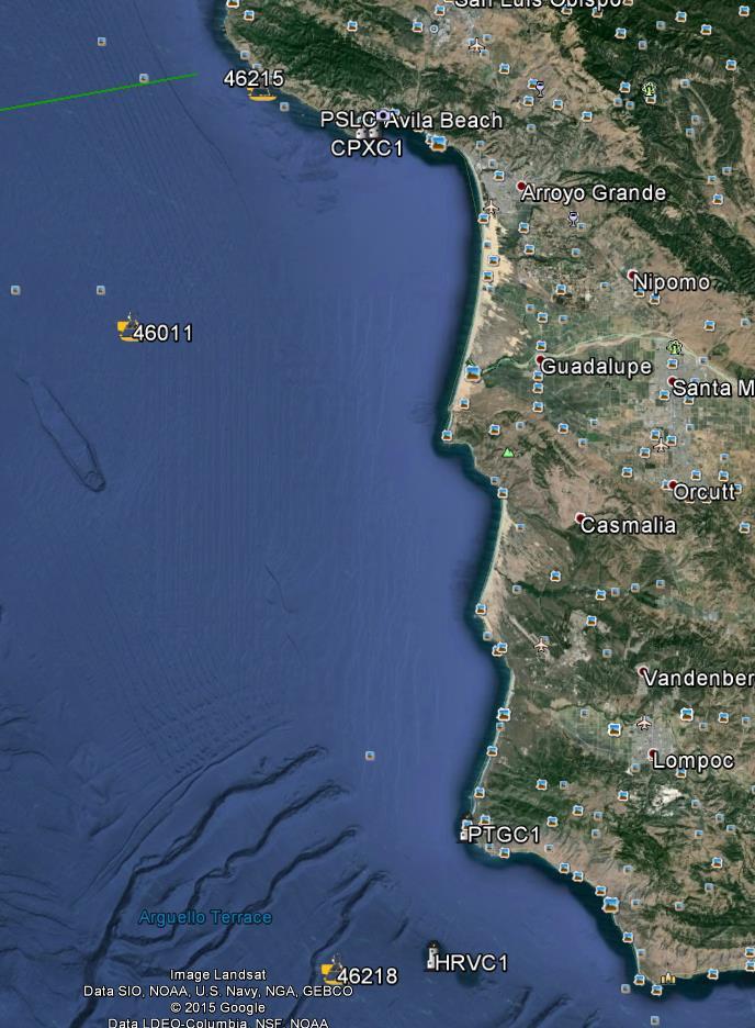
 Base of operations: Oxnard,CA & San Luis Obispo, CA Two 1-week field period to sample spring/neap cycle within the in-situ sampling period")
13 Airspace and proposed flight operations for the pilot experiment 5-6 flights planned for the pilot experiment (4.5 hrs endurance) Base of operations: Oxnard,CA & San Luis Obispo, CA Two 1-week field period to sample spring/neap cycle within the in-situ sampling period (June (deploy) and August 2-6 (recovery))


14 Airspace and proposed flight operations for the pilot experiment 2 km

15 NAWCWD PT. MUGU SEA TEST RANGE SUA USN FACSFAC SAN DIEGO 6 5 W-283 6D W-532N 7D 7E W-532S 7C 6E W-285 5D E D C 6C E M M W-537 W-289S 28
16 NOAA monthly tide predictions JUNE 2015
17 NOAA monthly tide predictions JULY 2015
18 Wind climatology Dorman & Winant 1995
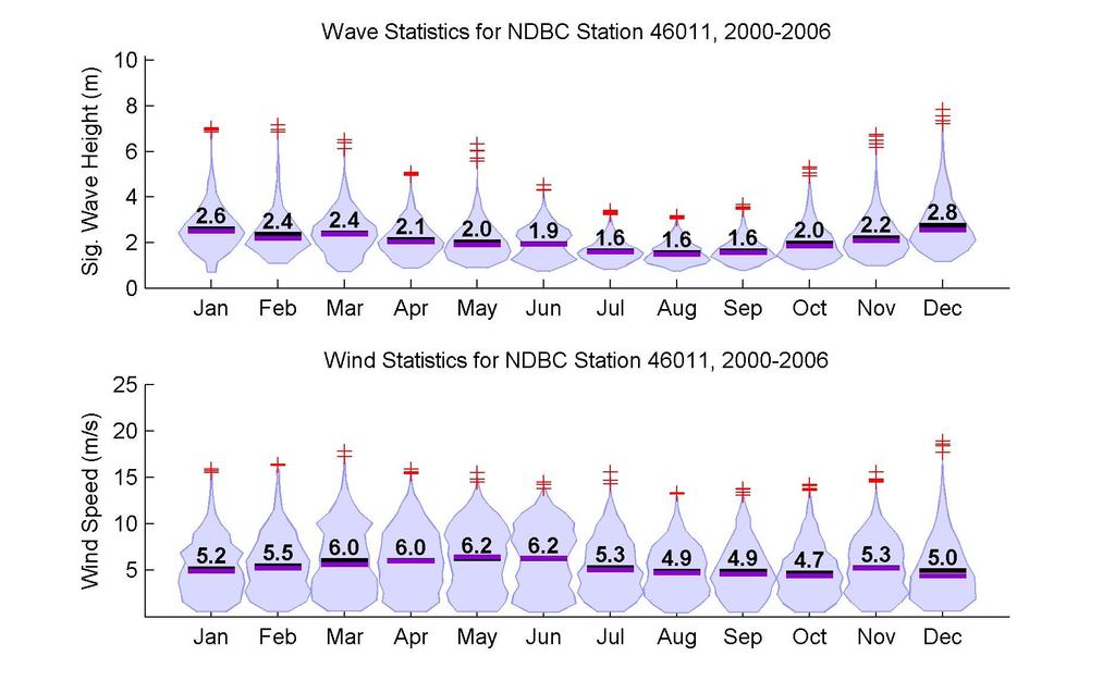
19 Wind/Wave climatology NDBC 46011
20 Wind/Wave climatology NDBC 46011

21 SST front climatology Castelao JGR 2006

22 SST front climatology Castelao JGR 2006


23 Notes on Airborne Measurements of Surf Zone Surface Kinematics in the Gulf of Mexico Perspective view of the 3D Lidar point cloud color-coded for height (referenced to WGS84) as the aircraft went across the surf zone in Gulf Shores, AL on October The wind direction is shown as blue arrows, with wind waves propagating in the same direction off the beach. Note the lack of returns while flying over slicks, also apparent in the IR imagery (see figure 3) Composite uncalibrated infrared image measured from the MASS on October as the aircraft went across the shores on its way back to the airport. Temperature range in the water is +/-0.3C. Note the abundance of temperature structures, ranging from smaller scales close to shore, the apparent colder slicks ( m) and signatures of Langmuir circulation aligned with the wind direction offshore ( m). Distances are in meters, relative to a reference point located at the Gulf Shores Airport (KJKA).

24 Notes on Airborne Measurements of Surf Zone Surface Kinematics in the Gulf of Mexico

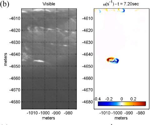
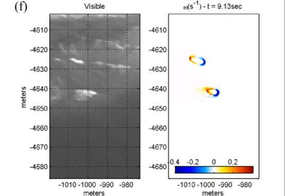
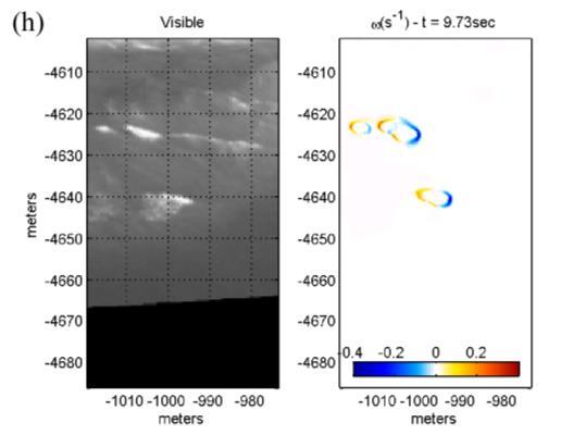
25 Notes on Airborne Measurements of Surf Zone Surface Kinematics in the Gulf of Mexico Sample high-resolution visible image collected from the MASS (top) and the corresponding vertical vorticity computed from the velocity field derived from pair of subsequent visible images using optical flow techniques, and apparent at each end of the segments of the breaking waves. Note that that this aerial coverage over large sections of beach complements the local in situ measurements of currents and vorticity by Dave Clark et al. (GRL 2013). The IR imagery can be processed using PIV and optical flow techniques to measure surface velocity fields in the surf zone.

26 Notes on Airborne Measurements of Surf Zone Surface Kinematics in the Gulf of Mexico
Airborne Remote Sensing of Surface and Internal Wave Processes on the Inner Shelf
 DISTRIBUTION STATEMENT A. Approved for public release; distribution is unlimited. Airborne Remote Sensing of Surface and Internal Wave Processes on the Inner Shelf W. Kendall Melville Scripps Institution
Wave-Phase-Resolved Air-Sea Interaction
 DISTRIBUTION STATEMENT A. Approved for public release; distribution is unlimited. Wave-Phase-Resolved Air-Sea Interaction W. Kendall Melville Scripps Institution of Oceanography (SIO) UC San Diego La Jolla,
The development of high resolution global ocean surface wave-tidecirculation
 PICES Annual Meeting in Qingdao The development of high resolution global ocean surface wave-tidecirculation coupled model Fangli Qiao, Qi Shu and Bin Xiao First Institute of Oceanography, SOA, China Oct
Long term observations of internal waves with shore based video cameras. Ata Suanda and John A. Barth
 Long term observations of internal waves with shore based video cameras Ata Suanda and John A. Barth Internal wave? What is an internal wave? Interior oscillations What is an internal wave? Interior oscillations
An IOOS Operational Wave Observation Plan Supported by NOAA IOOS Program & USACE
 An IOOS Operational Wave Observation Plan Supported by NOAA IOOS Program & USACE R.E. Jensen, W.A. Birkemeier and W. Burnett JCOMM-Workshop on Wave Measurements from Buoys Wave Information to Application
The Influence of Breaking at the Ocean Surface on Oceanic Radiance and Imaging
 The Influence of Breaking at the Ocean Surface on Oceanic Radiance and Imaging W. Kendall Melville Scripps Institution of Oceanography, University of California, San Diego 9500 Gilman Drive La Jolla, CA
P2.17 OBSERVATIONS OF STRONG MOUNTAIN WAVES IN THE LEE OF THE MEDICINE BOW MOUNTAINS OF SOUTHEAST WYOMING
 P2.17 OBSERVATIONS OF STRONG MOUNTAIN WAVES IN THE LEE OF THE MEDICINE BOW MOUNTAINS OF SOUTHEAST WYOMING Larry D. Oolman 1, Jeffrey R. French 1, Samuel Haimov 1, David Leon 1, and Vanda Grubišić 2 1 University
Challenges in determining water surface in airborne LiDAR topobathymetry. Amar Nayegandhi, Dewberry 15 th Annual JALBTCX Workshop, June 11 th 2014
 Challenges in determining water surface in airborne LiDAR topobathymetry Amar Nayegandhi, Dewberry 15 th Annual JALBTCX Workshop, June 11 th 2014 Why topobathy LiDAR? Complements acoustic (multi-beam sonar)
An Atlas of Oceanic Internal Solitary Waves (February 2004) by Global Ocean Associates Prepared for Office of Naval Research Code 322 PO
 by Global Ocean Associates Prepared for Office of Naval Research Code 322 PO") Overview The is located in the North Atlantic Ocean between southern Ireland and southwest England (Figure 1). The Sea s western edge covers a continental shelf region characterized by rough and irregular
Overview The is located in the North Atlantic Ocean between southern Ireland and southwest England (Figure 1). The Sea s western edge covers a continental shelf region characterized by rough and irregular
Small Footprint Topo-Bathymetric LiDAR
 May 8, 2013 Small Footprint Topo-Bathymetric LiDAR PNAMP Remote Sensing Forum Russ Faux, Co-CEO, WSI Amar Nayegandhi, Manager of Elevation Technologies, Dewberry Colin Cooper, Senior Analyst, WSI Watershed
WAVE BREAKING AND DISSIPATION IN THE NEARSHORE
 WAVE BREAKING AND DISSIPATION IN THE NEARSHORE LONG-TERM GOALS Dr. Thomas C. Lippmann Center for Coastal Studies Scripps Institution of Oceanography University of California, San Diego 9500 Gilman Dr.
Southern California Beach Processes Study
 Southern California Beach Processes Study Torrey Pines Field Site 5th Quarterly Report 31 May 22 to California Resources Agency and California Department of Boating and Waterways R.T. Guza 1, W.C. O Reilly
Digital Elevation Models
 Digital Elevation Models National Elevation Dataset 14-Oct-14 GEO327G/386G, UT Austin 1 Data Sets US DEM series 7.5, 30, 1 o for conterminous US 7.5, 15 for Alaska US National Elevation Data (NED) GTOPO30
Mass coral mortality under local amplification of 2 C ocean warming
 Mass coral mortality under local amplification of C ocean warming Thomas M. DeCarlo, Anne L. Cohen, George T.F. Wong, Kristen A. Davis, Pat Lohmann, Keryea Soong correspondence to: tdecarlo@uwa.edu.au
Rip Currents Onshore Submarine Canyons: NCEX Analysis
 Rip Currents Onshore Submarine Canyons: NCEX Analysis Dr. Thomas C. Lippmann Civil and Environmental Engineering & Geodetic Science, Byrd Polar Research Center, 1090 Carmack Rd., Ohio State University,
Prediction of Nearshore Waves and Currents: Model Sensitivity, Confidence and Assimilation
 Prediction of Nearshore Waves and Currents: Model Sensitivity, Confidence and Assimilation H. Tuba Özkan-Haller College of Oceanic and Atmospheric Sciences Oregon State University, 104 Ocean Admin Bldg
AN EXPERIMENTAL INVESTIGATION OF SPILLING BREAKERS
 AN EXPERIMENTAL INVESTIGATION OF SPILLING BREAKERS Prof. James H. Duncan Department of Mechanical Engineering University of Maryland College Park, Maryland 20742-3035 phone: (301) 405-5260, fax: (301)
Wave Breaking, Infragravity Waves, And Sediment Transport In The Nearshore
 Wave Breaking, Infragravity Waves, And Sediment Transport In The Nearshore Dr. Thomas C. Lippmann Center for Coastal Studies Scripps Institution of Oceanography University of California, San Diego La Jolla,
Theory and Application Introductory Oceanography Ray Rector: Instructor
 OCEAN TIDES Theory and Application Introductory Oceanography Ray Rector: Instructor Tidal Concepts Tides are extremely swift, very long-wavelength, shallow-water waves Tides are periodic short-term changes
Extreme wave events in the Gulf of Tehuantepec
 Extreme wave events in the Gulf of Tehuantepec W. K. Melville, L. Romero, and J. M. Kleiss Scripps Institution of Oceanography, University of California San Diego, La Jolla, CA 99-, USA Abstract. Observations
Oceans and the Global Environment: Lec 2 taking physics and chemistry outdoors. the flowing, waving ocean
 Oceans and the Global Environment: Lec 2 taking physics and chemistry outdoors the flowing, waving ocean Peter Rhines 1 Eric Lindahl 2 Bob Koon 2, Julie Wright 3 www.ocean.washington.edu/courses/has221a-08
San Diego Coastal Ocean Observing System
 California Clean Beaches Initiative San Diego Coastal Ocean Observing System WWW.SDCOOS.ORG Presentation to Imperial Beach City Council August 3, 2005 Eric J. Terrill, Ph.D. Scripps Institution of Oceanography
Imprints of Coastal Mountains on Ocean Circulation and Variability
 Imprints of Coastal Mountains on Ocean Circulation and Variability Shang-Ping Xie 1 with C.-H. Chang 1, W. Zhuang 2, N. Schneider 1, J. Small 3, B. Taguchi 4, and H. Sasaki 4 1 IPRC, University of Hawaii
Determination of the Spatial Variation of the Atmosphere and Ocean Wave Fields in Extremely Light Wind Regimes
 Determination of the Spatial Variation of the Atmosphere and Ocean Wave Fields in Extremely Light Wind Regimes Gennaro H. Crescenti U.S. Dept. Commerce / NOAA Air Resources Laboratory Field Research Division
Intraseasonal Variability in Sea Level Height in the Bay of Bengal: Remote vs. local wind forcing & Comparison with the NE Pacific Warm Pool
 Intraseasonal Variability in Sea Level Height in the Bay of Bengal: Remote vs. local wind forcing & Comparison with the NE Pacific Warm Pool Shang-Ping Xie 1,3, Xuhua Cheng 2,3, Julian P. McCreary 3 1.
Air-Sea Interaction Spar Buoy Systems
 DISTRIBUTION STATEMENT A: Distribution approved for public release; distribution is unlimited Air-Sea Interaction Spar Buoy Systems Hans C. Graber CSTARS - University of Miami 11811 SW 168 th Street, Miami,
G. Meadows, H. Purcell and L. Meadows University of Michigan
 www.coj.net/departments/fire+and+rescue/emergency+preparedness/rip+current.htm G. Meadows, H. Purcell and L. Meadows Over 80% of all surf related rescues are attributable to Rip Currents According to the
TIDES. Theory and Application
 TIDES Theory and Application Tidal Concepts Tides are extremely swift, very long-wavelength, shallow-water waves Tides are periodic short-term changes in sea level at a particular place caused by the gravitational
Chapter. The Dynamic Ocean
 Chapter The Dynamic Ocean An ocean current is the mass of ocean water that flows from one place to another. 16.1 The Composition of Seawater Surface Circulation Surface Currents Surface currents are movements
PUV Wave Directional Spectra How PUV Wave Analysis Works
 PUV Wave Directional Spectra How PUV Wave Analysis Works Introduction The PUV method works by comparing velocity and pressure time series. Figure 1 shows that pressure and velocity (in the direction of
Lagrangian Tracer Transport and Dispersion in Shallow Tidal Inlets & River Mouths
 DISTRIBUTION STATEMENT A: Approved for public release; distribution is unlimited. Lagrangian Tracer Transport and Dispersion in Shallow Tidal Inlets & River Mouths R. T. Guza & Falk Feddersen Scripps Institution
SURFACE CURRENTS AND TIDES
 NAME SURFACE CURRENTS AND TIDES I. Origin of surface currents Surface currents arise due to the interaction of the prevailing wis a the ocean surface. Hence the surface wi pattern (Figure 1) plays a key
Rip Currents Onshore Submarine Canyons: NCEX Analysis
 Rip Currents Onshore Submarine Canyons: NCEX Analysis Dr. Thomas C. Lippmann Civil and Environmental Engineering & Geodetic Science, Byrd Polar Research Center, 1090 Carmack Rd., Ohio State University,
RIVET Satellite Remote Sensing and Small Scale Wave Process Analysis
 DISTRIBUTION STATEMENT A. Approved for public release; distribution is unlimited. RIVET Satellite Remote Sensing and Small Scale Wave Process Analysis Hans C. Graber RSMAS Department of Ocean Sciences
SFM mapping of coastal erosion at Point Woronzof. Gennady Gienko, PhD Department of Geomatics, UAA
 SFM mapping of coastal erosion at Point Woronzof Gennady Gienko, PhD Department of Geomatics, UAA ggienko@alaska.edu POINT WORONZOF Point Woronzof bluff 135 ft elevation Point Woronzof bluff Pt. Woronzof
Impact of the tides, wind and shelf circulation on the Gironde river plume dynamics
 Impact of the tides, wind and shelf circulation on the Gironde river plume dynamics F. Toublanc 1, N. Ayoub 2, P. Marsaleix 3, P. De Mey 2 1 CNES/LEGOS 2 CNRS/LEGOS 3 CNRS/LA, Toulouse, France 5th GODAE
from a decade of CCD temperature data
 (Some of) What we have learned from a decade of CCD temperature data Craig Gelpi and Karen Norris Long Beach Aquarium of the Pacific August 15, 2008 Introduction Catalina Conservancy Divers collected temperature
Atmospheric & Ocean Circulation- I
 Atmospheric & Ocean Circulation- I First: need to understand basic Earth s Energy Balance 1) Incoming radiation 2) Albedo (reflectivity) 3) Blackbody Radiation Atm/ Ocean movement ultimately derives from
13.6 AIRBORNE RADAR OBSERVATIONS OF BREAKING WAVES/ROTORS IN THE LEE OF THE MEDICINE BOW MOUNTAINS IN SE WYOMING, USA
 13.6 AIRBORNE RADAR OBSERVATIONS OF BREAKING WAVES/ROTORS IN THE LEE OF THE MEDICINE BOW MOUNTAINS IN SE WYOMING, USA Jeffrey R. French 1 *, Samuel Haimov 1, Larry Oolman 1, Vanda Grubišić 2, and Dave
An Observational and Modeling Study to Quantify the Space/Time Scales of Inner Shelf Ocean Variability and the Potential Impacts on Acoustics
 DISTRIBUTION STATEMENT A. Approved for public release; distribution is unlimited. An Observational and Modeling Study to Quantify the Space/Time Scales of Inner Shelf Ocean Variability and the Potential
The Composition of Seawater
 The Composition of Seawater Salinity Salinity is the total amount of solid material dissolved in water. Most of the salt in seawater is sodium chloride, common table salt. Element Percent Element Percent
Nortek Technical Note No.: TN-021. Chesapeake Bay AWAC Evaluation
 Nortek Technical Note No.: TN-021 Title: Chesapeake Bay AWAC Evaluation Last Edited: October 5, 2004 Authors: Eric Siegel-NortekUSA, Chris Malzone-NortekUSA, Torstein Pedersen- Number of Pages: 12 Chesapeake
Boost Your Skills with On-Site Courses Tailored to Your Needs
 Boost Your Skills with On-Site Courses Tailored to Your Needs www.aticourses.com The Applied Technology Institute specializes in training programs for technical professionals. Our courses keep you current
MAPCO2 Buoy Metadata Report Project Title:
 MAPCO2 Buoy Metadata Report Project Title: Autonomous Multi-parameter Measurements from a Drifting Buoy During the SO GasEx Experiment Funding Agency: NOAA Global Carbon Cycle program PI(s): Christopher
Airborne Coherent Wind Lidar measurements of vertical and horizontal wind speeds for the investigation of gravity waves
 Airborne Coherent Wind Lidar measurements of vertical and horizontal wind speeds for the investigation of gravity waves 18 th Coherent Laser Radar Conference, Boulder, CO, USA 27 June to 1 July 2016 Benjamin
Figure 4, Photo mosaic taken on February 14 about an hour before sunset near low tide.
 The Impact on Great South Bay of the Breach at Old Inlet Charles N. Flagg and Roger Flood School of Marine and Atmospheric Sciences, Stony Brook University Since the last report was issued on January 31
Radar Remote Sensing of Waves and Currents in the Nearshore Zone
 Radar Remote Sensing of Waves and Currents in the Nearshore Zone Stephen J. Frasier Microwave Remote Sensing Laboratory Knowles Engineering Bldg., Rm. 113A University of Massachusetts Amherst, MA 01003
Undertow - Zonation of Flow in Broken Wave Bores
 Nearshore Circulation Undertow and Rip Cells Undertow - Zonation of Flow in Broken Wave Bores In the wave breaking process, the landward transfer of water, associated with bore and surface roller decay
Lecture Outlines PowerPoint. Chapter 15 Earth Science, 12e Tarbuck/Lutgens
 Lecture Outlines PowerPoint Chapter 15 Earth Science, 12e Tarbuck/Lutgens 2009 Pearson Prentice Hall This work is protected by United States copyright laws and is provided solely for the use of instructors
Beach Wizard: Development of an Operational Nowcast, Short-Term Forecast System for Nearshore Hydrodynamics and Bathymetric Evolution
 Beach Wizard: Development of an Operational Nowcast, Short-Term Forecast System for Nearshore Hydrodynamics and Bathymetric Evolution Ad Reniers Civil Engineering and Geosciences, Delft University of Technology
A study of advection of short wind waves by long waves from surface slope images
 A study of advection of short wind waves by long waves from surface slope images X. Zhang, J. Klinke, and B. Jähne SIO, UCSD, CA 993-02, USA Abstract Spatial and temporal measurements of short wind waves
Wave research at Department of Oceanography, University of Hawai i
 Wave research at Department of Oceanography, University of Hawai i Hawaii wave climate. Directional waverider buoys around Hawaii. Past and present wave-related research projects. Effect of tides on wave
The impact of ocean bottom morphology on the modelling of long gravity waves from tides and tsunami to climate
 The impact of ocean bottom morphology on the modelling of long gravity waves from tides and tsunami to climate Christian Le Provost and Florent Lyard Laboratoire d Etudes en Géophysique et Océanographie
Synoptic Lab, MET 421, Test 2
 Name Synoptic Lab, MET 421, Test 2 1) For a 15 ms -1 east wind blowing towards Milwaukee a) Calculate the distance to the east shore of Lake Michigan. You can use a distance calculator website such as
South Bay Coastal Ocean Observing System California Clean Beaches Initiative
 South Bay Coastal Ocean Observing System California Clean Beaches Initiative Quarterly Report March 2004 to City of Imperial Beach Eric Terrill 1 1 Scripps Institution of Oceanography, University of California,
Waves, Bubbles, Noise, and Underwater Communications
 Waves, Bubbles, Noise, and Underwater Communications Grant B. Deane Marine Physical Laboratory, Scripps Institution of Oceanography UCSD, La Jolla, CA 92093-0238 phone: (858) 534-0536 fax: (858) 534-7641
1 st Tidal and Water Level Working Group Meeting DHN, Niteroi, Brazil 31/03/09 02/04/09 Vertical Offshore Reference Framework (VORF) Chris Jones
 Chris Jones") 1 st Tidal and Water Level Working Group Meeting DHN, Niteroi, Brazil 31/03/09 02/04/09 Vertical Offshore Reference Framework (VORF) Chris Jones United Kingdom Hydrographic Office Presentation Structure
1 st Tidal and Water Level Working Group Meeting DHN, Niteroi, Brazil 31/03/09 02/04/09 Vertical Offshore Reference Framework (VORF) Chris Jones United Kingdom Hydrographic Office Presentation Structure
The Influence of Breaking at the Ocean Surface on Oceanic Radiance and Imaging
 The Influence of Breaking at the Ocean Surface on Oceanic Radiance and Imaging W. Kendall Melville Scripps Institution of Oceanography, University of California, San Diego 9500 Gilman Drive La Jolla, CA
An Atlas of Oceanic Internal Solitary Waves (May 2002) by Global Ocean Associates Prepared for the Office of Naval Research - Code 322PO
 by Global Ocean Associates Prepared for the Office of Naval Research - Code 322PO") Overview is located in the western Pacific Ocean along the west side of the Philippines (between approximately 5 o and 11 o N. latitude and 117 o and 123 o E. longitude). It is a deepwater sea, roughly
Overview is located in the western Pacific Ocean along the west side of the Philippines (between approximately 5 o and 11 o N. latitude and 117 o and 123 o E. longitude). It is a deepwater sea, roughly
Abrupt marine boundary layer changes revealed by airborne in situ and lidar measurements
 Abrupt marine boundary layer changes revealed by airborne in situ and lidar measurements David A. Rahn 1, Thomas R. Parish 2, and David Leon 2 1 Univeristy of Kansas 2 Univeristy of Wyoming Precision Atmospheric
The GCOOS Mooring Plan Element Draft, 19 February 2011
 The GCOOS Mooring Plan Element Draft, 19 February 2011 1. Introduction In order to proceed with the establishment of a regional coastal ocean observing system for the Gulf of Mexico, it is essential to
Uncertainty Estimates in Satellite Derived Bathymetry
 Uncertainty Estimates in Satellite Derived Bathymetry Richard Flemmings, TCarta #chcnsc2018 Introduction and Overview 1. TCarta 2. Satellite Derived Bathymetry Overview 3. Satellite Derived Bathymetry
Applications of Collected Data from Argos Drifter, NOAA Satellite Tracked Buoy in the East Sea
 Applications of Collected Data from Argos Drifter, NOAA Satellite Tracked Buoy in the East Sea Young-Sang Suh (yssuh@nfrdi.re.kr) Ocean Research Team, National Fisheries Research and Development Institute,
Alongshore wind stress (out of the page) Kawase/Ocean 420/Winter 2006 Upwelling 1. Coastal upwelling circulation
 Kawase/Ocean 420/Winter 2006 Upwelling 1. Coastal upwelling circulation") Kawase/Ocean 420/Winter 2006 Upwelling 1 Coastal upwelling circulation We found that in the northern hemisphere, the transport in the surface Ekman layer is to the right of the wind. At the bottom, there
Kawase/Ocean 420/Winter 2006 Upwelling 1 Coastal upwelling circulation We found that in the northern hemisphere, the transport in the surface Ekman layer is to the right of the wind. At the bottom, there
CHANGE OF THE BRIGHTNESS TEMPERATURE IN THE MICROWAVE REGION DUE TO THE RELATIVE WIND DIRECTION
 JP4.12 CHANGE OF THE BRIGHTNESS TEMPERATURE IN THE MICROWAVE REGION DUE TO THE RELATIVE WIND DIRECTION Masanori Konda* Department of Geophysics, Graduate School of Science, Kyoto University, Japan Akira
Satellite Observations of Equatorial Planetary Boundary Layer Wind Shear
 Satellite Observations of Equatorial Planetary Boundary Layer Wind Shear David Halpern and Michael Garay NASA / California Institute of Technology Jet Propulsion Laboratory Pasadena, California, USA Thanks
Global Ocean Internal Wave Database
 Global Ocean Internal Wave Database Victor Klemas Graduate College of Marine Studies University of Delaware Newark, DE 19716 phone: (302) 831-8256 fax: (302) 831-6838 email: klemas@udel.edu Quanan Zheng
Reply of Guyana Annex R2
 Summary of Findings: Analysis of Recent Shoreline Revisions to the This report assesses recent shoreline changes made to the 2005 edition of Dutch nautical chart NL 2218. This new edition is credited jointly
THE SPATIAL VARIABILITY OF LARGE SCALE SAND BARS
 THE SPATIAL VARIABILITY OF LARGE SCALE SAND BARS C. R. Worley 1, T. C. Lippmannl, j. \y. Haines 2, A. H. Sallenger 2 Abstract In this work we describe preliminary results from a newly developed aerial
Exercise: Satellite Imagery Analysis. 29 June 2016 Japan Meteorological Agency
 Exercise: Satellite Imagery Analysis 29 June 2016 Japan Meteorological Agency Contents 1. Fog/Stratiform Cloud 2. Cb (Cumulonimbus)/Cg (Cumulus congestus) 3. Upper-level Flow Jet stream, upper trough,
Columbia River Plume 2006 OSU Ocean Mixing Nash, Kilcher, Moum et al. CR05 Cruise Report (RISE Pt. Sur, May )
") CR05 Cruise Report (RISE Pt. Sur, May 21-31 2006) Group Summary: Participants: Pt. Sur Ocean Mixing Group: Jonathan Nash, Levi Kilcher, Alexander Perlin, Greg Avicola; Pt. Sur UW: Emily Spahn (Alex Horner-Devine;
CR05 Cruise Report (RISE Pt. Sur, May 21-31 2006) Group Summary: Participants: Pt. Sur Ocean Mixing Group: Jonathan Nash, Levi Kilcher, Alexander Perlin, Greg Avicola; Pt. Sur UW: Emily Spahn (Alex Horner-Devine;
Assessing the quality of Synthetic Aperture Radar (SAR) wind retrieval in coastal zones using multiple Lidars
 wind retrieval in coastal zones using multiple Lidars") Assessing the quality of Synthetic Aperture Radar (SAR) wind retrieval in coastal zones using multiple Lidars Tobias Ahsbahs Merete Badger, Ioanna Karagali, Xiaoli Larsen What is the coastal zone? Coastal
Assessing the quality of Synthetic Aperture Radar (SAR) wind retrieval in coastal zones using multiple Lidars Tobias Ahsbahs Merete Badger, Ioanna Karagali, Xiaoli Larsen What is the coastal zone? Coastal
OPERATIONAL AMV PRODUCTS DERIVED WITH METEOSAT-6 RAPID SCAN DATA. Arthur de Smet. EUMETSAT, Am Kavalleriesand 31, D Darmstadt, Germany ABSTRACT
 OPERATIONAL AMV PRODUCTS DERIVED WITH METEOSAT-6 RAPID SCAN DATA Arthur de Smet EUMETSAT, Am Kavalleriesand 31, D-64295 Darmstadt, Germany ABSTRACT EUMETSAT started its Rapid Scanning Service on September
Vortical motions under short wind waves
 Vortical motions under short wind waves X. Zhang and C. S. Cox Scripps Institution of Oceanography, UCSD, CA 9293-23, USA Abstract The flow structures under ocean wind waves are of great significance in
Composition, Chemistry and Transport in the UT/LS during the Asian Monsoon: Results from the IAGOS-CARIBIC Observatory
 Composition, Chemistry and Transport in the UT/LS during the Asian Monsoon: Results from the IAGOS-CARIBIC Observatory Angela K. Baker & the CARIBIC team Monsoon Workshop 08 March 2016 The IAGOS-CARIBIC
Undertow - Zonation of Flow in Broken Wave Bores
 Lecture 22 Nearshore Circulation Undertow - Zonation of Flow in Broken Wave Bores In the wave breaking process, the landward transfer of water, associated with bore and surface roller decay within the
The Coriolis Effect - Deflect the Arrows!
 NAME: DATE: The Coriolis Effect - Deflect the Arrows Directions: The Circle below represents the Earth. The equator is present, dividing the image into the Northern and Southern hemispheres. The arrows
Yellow Sea with contributions by John R. Apel
 with contributions by John R. Apel Overview The is a shallow inland sea lying between northeastern China and the Korean Peninsula, with depths in its central north-south trough in excess of 60 to 80 m
Computational Analysis of Oil Spill in Shallow Water due to Wave and Tidal Motion Madhu Agrawal Durai Dakshinamoorthy
 Computational Analysis of Oil Spill in Shallow Water due to Wave and Tidal Motion Madhu Agrawal Durai Dakshinamoorthy 1 OUTLINE Overview of Oil Spill & its Impact Technical Challenges for Modeling Review
Super-parameterization of boundary layer roll vortices in tropical cyclone models
 DISTRIBUTION STATEMENT A. Approved for public release; distribution is unlimited. Super-parameterization of boundary layer roll vortices in tropical cyclone models PI Isaac Ginis Graduate School of Oceanography
REMOTE SENSING APPLICATION in WIND ENERGY
 REMOTE SENSING APPLICATION in WIND ENERGY Siraj Ahmed Professor & Head Department of Mechanical Engineering Maulana Azad National Iinstitute of Technology Bhopal, India sirajahmed@manit.ac.in Contents
Atmospheric & Ocean Circulation-
 Atmospheric & Ocean Circulation- Overview: Atmosphere & Climate Atmospheric layers Heating at different latitudes Atmospheric convection cells (Hadley, Ferrel, Polar) Coriolis Force Generation of winds
Yelena L. Pichugina 1,2, R. M. Banta 2, N. D. Kelley 3, W. A. Brewer 2, S. P. Sandberg 2, J. L. Machol 1, 2, and B. J. Jonkman 3
 4 th Symposium on Lidar Atmos. Applic, AMS, Phoenix, Arizona, January 2009 5.5 LIDAR MEASUREMENTS OF EXTREME INFLOW EVENTS FOR WIND ENERGY OPERATIONS Yelena L. Pichugina 1,2, R. M. Banta 2, N. D. Kelley
Atmospheric Forcing and the Structure and Evolution of the Upper Ocean in the Bay of Bengal
 DISTRIBUTION STATEMENT A. Approved for public release; distribution is unlimited. Atmospheric Forcing and the Structure and Evolution of the Upper Ocean in the Bay of Bengal J. Thomas Farrar and Robert
GNSS Technology for the Determination of Real-Time Tidal Information
 GNSS Technology for the Determination of Real-Time Tidal Information Benjamin Kidder C-Nav Positioning Solutions European region Outline of Topics Covered Introduction to Tides Past and Present Methods
Currents measurements in the coast of Montevideo, Uruguay
 Currents measurements in the coast of Montevideo, Uruguay M. Fossati, D. Bellón, E. Lorenzo & I. Piedra-Cueva Fluid Mechanics and Environmental Engineering Institute (IMFIA), School of Engineering, Research
LASER INDUCED FLUORESCENCE MEASUREMENTS OF CARBON DIOXIDE DISSOLUTION IN WAVE-BREAKING TURBULENCE
 LASER INDUCED FLUORESCENCE MEASUREMENTS OF CARBON DIOXIDE DISSOLUTION IN WAVE-BREAKING TURBULENCE Yasunori Watanabe 1, Junichi Otsuka 2 and Ayumi Saruwatari 3 Spatial distributions of dissolved carbon
Short-period gravity waves over a high-latitude observation site: Rothera, Antarctica
 Short-period gravity waves over a high-latitude observation site: Rothera, Antarctica K. Nielsen, D. Broutman, M. Taylor, D. Siskind, S. Eckermann, K. Hoppel, R. Hibbins, M. Jarvis, N. Mitchell, J. Russell
Measurement of Coastal & Littoral Toxic Material Tracer Dispersion. Dr. Robert E. Marshall T41 NSWCDD
 Measurement of Coastal & Littoral Toxic Material Tracer Dispersion Dr. Robert E. Marshall robert.e.marshall@navy.mil T41 NSWCDD Mouth of the Piankatank River Chesapeake Bay Model this for CB defense? Ground
High Frequency Acoustical Propagation and Scattering in Coastal Waters
 High Frequency Acoustical Propagation and Scattering in Coastal Waters David M. Farmer Graduate School of Oceanography (educational) University of Rhode Island Narragansett, RI 02882 phone: (401) 874-6222
SPATIAL AND TEMPORAL VARIATIONS OF INTERNAL WAVES IN THE NORTHERN SOUTH CHINA SEA
 SPATIAL AND TEMPORAL VARIATIONS OF INTERNAL WAVES IN THE NORTHERN SOUTH CHINA SEA Weigen Huang (1), Johnny Johannessen (2,3), Werner Alpers (4) Jingsong Yang (1), Xilin Gan (1) (1) Second Institute of
Pathways Interns: Annika O Dea, Ian Conery, Andrea Albright
 1 REMOTE SENSING OF COASTAL MORPHODYNAMICS 237 237 237 217 217 217 2 2 2 8 119 27 252 174.59 255 255 255 163 163 163 131 132 122 239 65 53 11 135 12 112 92 56 62 12 13 12 56 48 13 12 111 Kate Brodie Brittany
STUDY OF LOCAL WINDS IN MOUNTAINOUS COASTAL AREAS BY MULTI- SENSOR SATELLITE DATA
 STUDY OF LOCAL WINDS IN MOUNTAINOUS COASTAL AREAS BY MULTI- SENSOR SATELLITE DATA Werner Alpers Institute of Oceanography, University of Hamburg, Bundesstrasse 53, D-20146 Hamburg, Germany E-mail: alpers@ifm.uni-hamburg.de
ATMS 310 Tropical Dynamics
 ATMS 310 Tropical Dynamics Introduction Throughout the semester we have focused on mid-latitude dynamics. This is not to say that the dynamics of other parts of the world, such as the tropics, are any
Aquarius Brings New Understanding to Tropical Instability Waves (TIWs)
") Aquarius Brings New Understanding to Tropical Instability Waves (TIWs) Tong Lee1*, Gary Lagerloef2, Michelle M. Gierach1, Hsun-Ying Kao2, Simon Yueh1, Kathleen Dohan2 1NASA Jet Propulsion Laboratory, CalTech,
Aquarius Brings New Understanding to Tropical Instability Waves (TIWs) Tong Lee1*, Gary Lagerloef2, Michelle M. Gierach1, Hsun-Ying Kao2, Simon Yueh1, Kathleen Dohan2 1NASA Jet Propulsion Laboratory, CalTech,
Model activities at FIO: The essential mixing effects of the nonbreaking surface wave on general circulation and climate models
 Model activities at FIO: The essential mixing effects of the nonbreaking surface wave on general circulation and climate models Fangli Qiao First Institute of Oceanography, SOA, China May 22, 2015 Qingdao
The Wave Glider: A Mobile Buoy Concept for Ocean Science. 009 Liquid Robotics Inc.
 The Wave Glider: A Mobile Buoy Concept for Ocean Science 009 Liquid Robotics Inc. J. Manley & T. Richardson: Liquid Robotics Inc. DBCP XXV Paris September 28, 2009 1 Wave Glider Overview Unique Two Part
NSF's Ocean Observatories Initiative: Building Research Infrastructure for the Pacific Northwest and the Broader Community
 Agenda Item B.3.b Supplemental OOI PowerPoint April 2013 Ocean Observatories Initiative NSF's Ocean Observatories Initiative: Building Research Infrastructure for the Pacific Northwest and the Broader
Characterization of Boundary-Layer Meteorology During DISCOVER-AQ
 Characterization of Boundary-Layer Meteorology During DISCOVER-AQ Daniel M. Alrick and Clinton P. MacDonald Sonoma Technology, Inc. Gary A. Morris St. Edward s University for Texas Air Quality Research
PACIFIC NORTHWEST TEST OF A HYDROGRAPHIC AIRBORNE LASER SCANNER
 PACIFIC NORTHWEST TEST OF A HYDROGRAPHIC AIRBORNE LASER SCANNER Green LiDAR Workshop June 3 7, 2012 Russell Faux, Principal Watershed Sciences, Inc. 517 SW 2 nd Street, Suite 400 Corvallis, OR 97333 541