1 st Tidal and Water Level Working Group Meeting DHN, Niteroi, Brazil 31/03/09 02/04/09 Vertical Offshore Reference Framework (VORF) Chris Jones
|
|
|
- Evan Cain
- 6 years ago
- Views:
Transcription

 Chris Jones United Kingdom")
1 1 st Tidal and Water Level Working Group Meeting DHN, Niteroi, Brazil 31/03/09 02/04/09 Vertical Offshore Reference Framework (VORF) Chris Jones United Kingdom Hydrographic Office
2 Presentation Structure What is VORF? Brief overview of the technical development Why is VORF needed?
3 What is VORF? VORF = Vertical Offshore Reference Frame A set of mathematical models of the major surfaces used in the current and future charting of UK home waters A suite of software utilities allowing the transformation of mapping and positioning data between the VORF surfaces
4 Current practice for bathymetric data processing Tide gauge observed tide (and time) Use co-tidal chart derived from survey vessel Tidal correction Sea Surface Issues: Complexity onshore and offshore operations, time Latency the process takes time and hence is expensive depth measurement (and time of observation) Charted depth Accuracy issues co-tidal charts have limited resolution and are derived from limited data; seabed gauges are expensive Inconsistency practices using Chart Datum are sometimes poorly defined and can lead to discrepancies LAT or use seabed gauge
5 Bathymetric data processing with VORF and GPS survey vessel (+GPS) Tidal correction = h ε VORF LAT Tidal correction Sea Surface depth measurement Charted depth = Depth measurement tidal correction h ε LAT Charted VORFdepth LAT GRS80 Ellipsoid - accessible everywhere via GPS
6 VORF surfaces: HAT MHWS MSL2000 MLWS OD(Newlyn) (OD other) LAT Chart Datum GRS80 Ellipsoid
7 Basic VORF functionality: Transforming data between vertical datums Example: Chart Datum to MLWS MLWS New data set in MLWS Chart Datum Existing survey expressed in CD Sea floor GRS80 Ellipsoid
8 Brief overview of the technical development of VORF
9 Technologies applied in development of VORF Tide gauge data GPS data Satellite altimetry Gravity field models Tidal modelling
10 VORF Overall Approach Find mean sea level Model lowest astronomical tide Combine surfaces
11 Overview of VORF computation method Tide gauge MSL interpolate MSL (altimetry) geoid MLWS Tidal modelling
12 Monthly MSL Observations Many tide gauge stations only have one month of observations. Variations due to winds, pressure, currents, etc. Correct by cross comparison North Shields Monthly MSL above RLR mm 2003 RLR = Revised Local Reference, which is sea level relative to the land. Year

13 Spatial Correlation Monthly MSL above RLR mm North Shields Immingham Whitby Year Correlations help to control the interpolation of MSL at stations where there are short series of data.
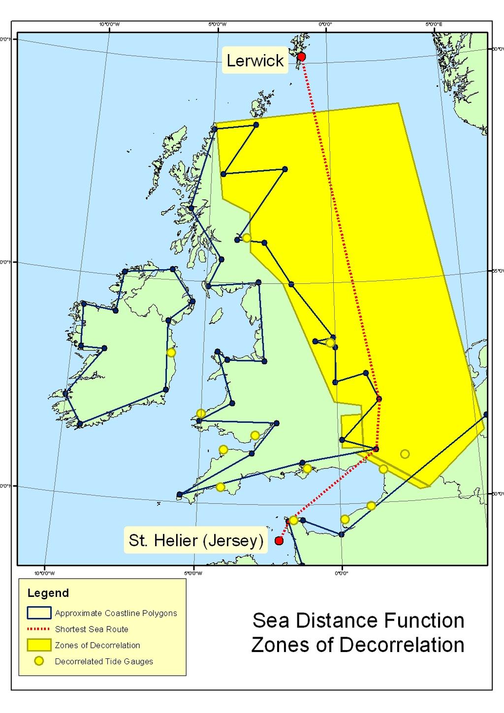
14 Spatial Correlation Scatter Plots PSMSL Tide Gauges Spatial Correlation Straight Line Distance (km) PSMSL Tide Gauges PSMSL Tide Gauges Spatial Correlation Spatial Correlation Sea Distance (km) -0.4 Sea Distance Adjusted for Decorrelated Zones (km)
15
 stations High quality continuous observations BUT low spatial")
16 Data sources: Tide Gauge data via the Permanent Service for Mean Sea Level (PSMSL) National Tidal and Sea Level Facility (NTSLF) stations High quality continuous observations BUT low spatial density

17 Data sources: Tide Gauges Admiralty Tide Table (ATT) Around 700 Standard and Secondary Port locations Good spatial density BUT occasionally low precision due to short term data series
18 Chart Datum: VORF aims to unify all these separate datums into one, seamless surface Process involves verifying the link between CD and Ordnance Datum (the landlevelling height datum)
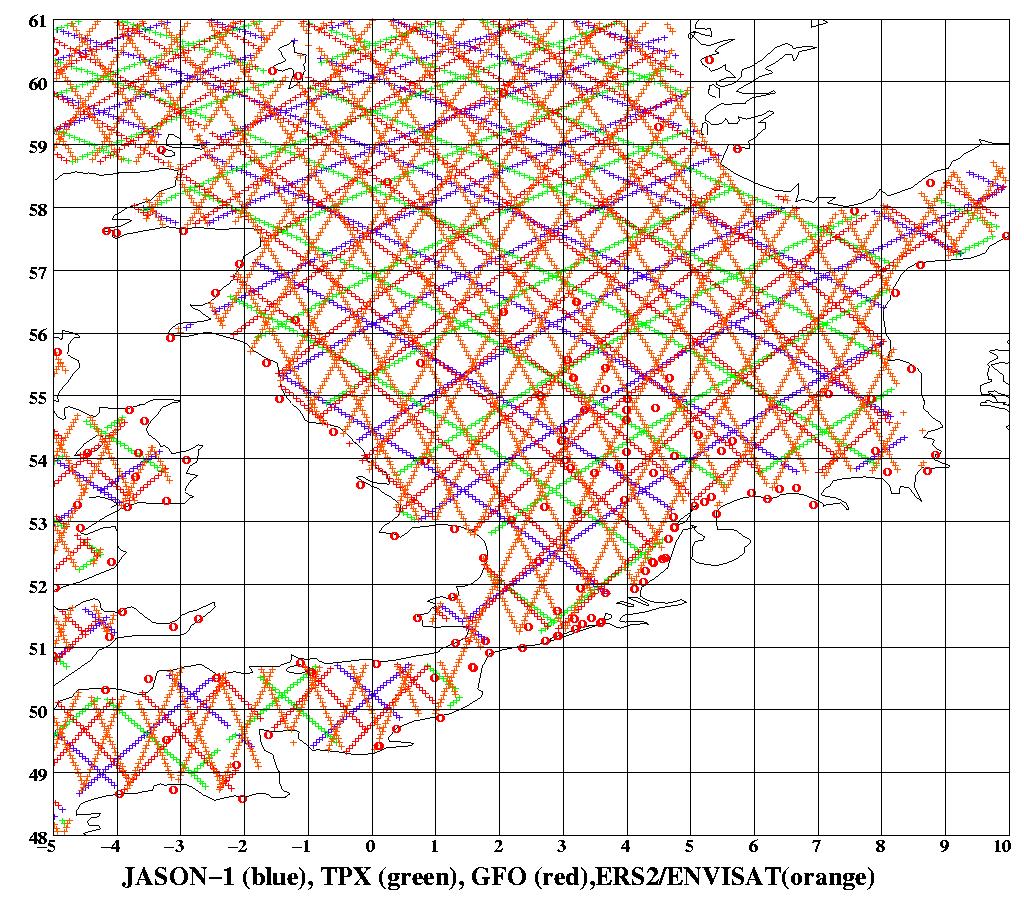


19 Technologies applied: Satellite Altimetry ENVISAT TOPEX JASON GFO ERS1/2
20 Technologies applied: OSGM05 the latest UK gravity field model (OSGM09 available soon)

21 River Datums

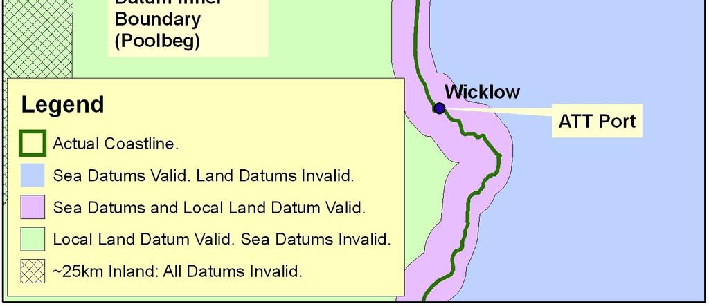
22 Use of Areas of Applicability

23 Boundaries of VORF Model: UK Continental Shelf
24 VORF software functionality Transformation between datums Estimated error in transformations Visualisation User error detection Point/file mode data import Deals with complexity of searching for special cases such as rivers and impounded datums. High speed data retrieval and processing.
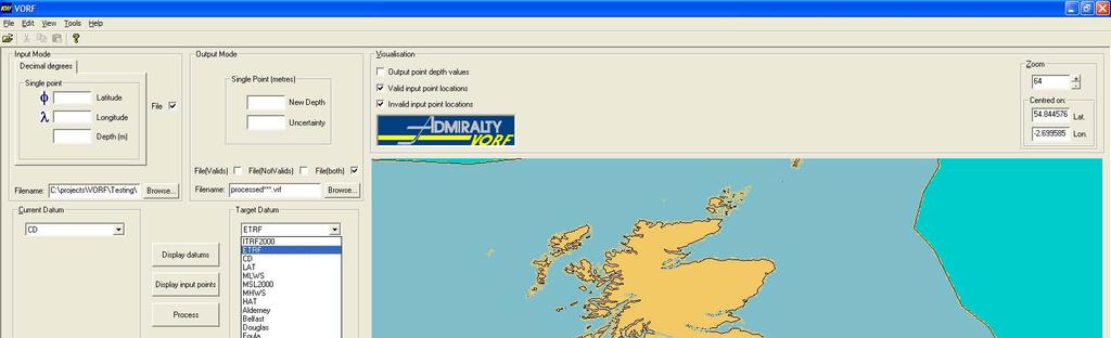
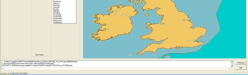
25 VORF Application
 University College London (UCL) has developed new concepts in high performance PiP tests Technique based on quadtree subdivision of analysis")
26 Ultra Rapid Point in Polygon (PiP) Benchmark Tests 400,000 line segment polygon set Conventional desktop PC (1 Gb RAM, 3 GHz processor) 8,000,000 queries carried out correctly in 16 seconds (including file reading) University College London (UCL) has developed new concepts in high performance PiP tests Technique based on quadtree subdivision of analysis space

27 Current progress: V2.0 delivered to UKHO Jan 08. Now to do: Stakeholders to be revisited Needs full testing Needs to be developed into robust software Safety case

28 Accuracy achieved VORF was designed to be accurate to ±0.1m 1 sigma close to shore and ±0.15m 1 sigma offshore. Initial investigations show that it is slightly greater than this in some areas, but it will still be fit for purpose. VORF will be released with estimations of the uncertainties of the surfaces.
29 Why is VORF needed? Continuing developments in GPS LIDAR and multibeam technology Analogy with the Ordnance Survey heighting reference systems on land To deal with the increased use of GPS-based hydrographic surveys submitted to UKHO
30 How can VORF benefit the UKHO? Cost and efficiency of surveys Quality control Enabling new technologies Developing new products
31 Navigational users Antenna offset CD GPS from VORF ETRF89 0 Surveyed depth of wreck/hazard/shoal from survey vessel equipped with GPS+VORF Elimination of remote tide gauges

32 Specialist applications Multibeam VORF Improved digital bathymetry Improved tidal models Tidal predictions at virtual tide stations accessible via satellite web link. Ship equipped with VORF and GPS is its own tide gauge compare current reading to prediction, plot enhanced route/timing for approach to critical areas.
33 Summary of VORF advantages VORF derives continuous surfaces, with fixed reference to ETRF89. It provides a consistent interpolation between Chart Datums, and methodology for extrapolation offshore. It eliminates some of the reliance on remote or expensive tidal observations. It has the potential to be built in to real-time applications. It fully exploits current and future GPS technology, and is the basis for future accuracy enhancements.
34 Conclusions VORF is an enabling technology Surveying without tide gauges cheaper, faster, more accurate New navigation and space management concepts Fully integrated data products SOLAS improved navigation in critical areas VORF will help UKHO in its development of marine charting and navigation products
GNSS Technology for the Determination of Real-Time Tidal Information
 GNSS Technology for the Determination of Real-Time Tidal Information Benjamin Kidder C-Nav Positioning Solutions European region Outline of Topics Covered Introduction to Tides Past and Present Methods
Introduction. VORF - Model Development and Principles. The required VORF model transformation accuracies were as follows:
 Introduction In 2006, the United Kingdom Hydrographic Office (UKHO) began testing of the Vertical Offshore Reference Frame (VORF), which had been developed on their behalf by the Department of Geomatic
Uncertainty Estimates in Satellite Derived Bathymetry
 Uncertainty Estimates in Satellite Derived Bathymetry Richard Flemmings, TCarta #chcnsc2018 Introduction and Overview 1. TCarta 2. Satellite Derived Bathymetry Overview 3. Satellite Derived Bathymetry
THE CHALLENGES OF A LARGE-AREA BATHYMETRIC SURVEY
 THE CHALLENGES OF A LARGE-AREA BATHYMETRIC SURVEY Agenda: - Introduction - Tender - Project Planning - Survey - Processing - Delivery - Conclusion 2 Introduction We know less of the oceans at our feet,
ICES Guidelines for Multibeam Echosounder Data (Compiled September 2006)
") ICES Guidelines for Multibeam Echosounder Data (Compiled September 2006) If you are considering producing a hydrographic survey please read the following information first. Your survey could be used to
ICES Guidelines for Multibeam Echosounder Data (Compiled September 2006) If you are considering producing a hydrographic survey please read the following information first. Your survey could be used to
S-44 edition 5 The IHO s New Standard For Hydrographic Surveys Chris Howlett Head of Seabed Data Centre United Kingdom Hydrographic Office
 S-44 edition 5 The IHO s New Standard For Hydrographic Surveys Chris Howlett Head of Seabed Data Centre United Kingdom Hydrographic Office Chairman of IHO Working Group that created S-44 edition 5 S-44
DUKC Chart Overlay. Presentation to IHO TWL and DQ Working Groups Wollongong, March 2014
 DUKC Chart Overlay Presentation to IHO TWL and DQ Working Groups Wollongong, March 2014 Outline Who is OMC? DUKC description & methodology. DUKC Chart Overlay concept. Chart Overlay application example.
ENVIRONMENT AGENCY GREAT OUSE AND 100 FT DRAIN QUARTERLY BATHYMETRIC SURVEY DECEMBER 2013 SITE SURVEY REPORT NO. H6787
 ENVIRONMENT AGENCY GREAT OUSE AND 100FT DRAIN QUARTERLY BATHYMETRIC SURVEY DECEMBER 2013 NO. H6787 LONGDIN & BROWNING (SURVEYS) LIMITED CHERRY TREE HOUSE CARMARTHEN ROAD SWANSEA SA1 1HE H6787 1 Measured
E4014 Construction Surveying. Hydrographic Surveys
 E4014 Construction Surveying Hydrographic Surveys Charts And Maps Hydrographic Chart an information medium and a tool for maritime traffic for the safety and ease of navigation contains information on
Real Time Surveying GPS and HYDRO Software for Tide and Swell Compensation
 Real Time Surveying GPS and HYDRO Software for Tide and Swell Compensation by Mr Michael Walker, B.Surv. (Otago) HYDRO Division Trimble Navigation New Zealand Ltd. Abstract This paper focuses on the use
INTERNATIONAL HYDROGRAPHIC SURVEY STANDARDS
 INTERNATIONAL HYDROGRAPHIC SURVEY STANDARDS by Gerald B. MILLS 1 I. Background The International Hydrographic Organization (IHO) traces its origin to the establishment of the International Hydrographic
14/10/2013' Bathymetric Survey. egm502 seafloor mapping
 egm502 seafloor mapping lecture 10 single-beam echo-sounders Bathymetric Survey Bathymetry is the measurement of water depths - bathymetry is the underwater equivalent of terrestrial topography. A transect
MIKE 21 Toolbox. Global Tide Model Tidal prediction
 MIKE 21 Toolbox Global Tide Model Tidal prediction MIKE Powered by DHI 2017 DHI headquarters Agern Allé 5 DK-2970 Hørsholm Denmark +45 4516 9200 Telephone +45 4516 9333 Support +45 4516 9292 Telefax mike@dhigroup.com
Marine Renewables Industry Association. Marine Renewables Industry: Requirements for Oceanographic Measurements, Data Processing and Modelling
 Marine Renewables Industry Association Marine Renewables Industry: Requirements for Oceanographic Measurements, Data Processing and Modelling October 2009 Table of Contents 1. Introduction... 1 2. Measurements
Hydrographic Surveying at The Port of London
 Hydrographic Surveying at The Port of London John Dillon-Leetch Port and Terminal Technology 2009 14 th October, Antwerp Overview Introduction Surveying the Thames Navigational Charting High Resolution
Paper for consideration by ENC Working Group. Use of AU6 ENC cells as an option for Bathymetric ENCs (benc)
") Paper for consideration by ENC Working Group Use of AU6 ENC cells as an option for Bathymetric ENCs (benc) Submitted by: Alvaro Sanchez (AHS) Executive Summary: Compilation of high density bathymetric
Paper for consideration by ENC Working Group Use of AU6 ENC cells as an option for Bathymetric ENCs (benc) Submitted by: Alvaro Sanchez (AHS) Executive Summary: Compilation of high density bathymetric
Reply of Guyana Annex R2
 Summary of Findings: Analysis of Recent Shoreline Revisions to the This report assesses recent shoreline changes made to the 2005 edition of Dutch nautical chart NL 2218. This new edition is credited jointly
BASELINE SURVEY, VISUAL - SITE SPECIFIC
 BASELINE SURVEY, VISUAL - SITE SPECIFIC Introduction As stated in SEPA s policy and in the Fish Farm Manual (1998), scientific data are required by SEPA in order to assess the existing condition on the
Bathymetry Data Collection for Subaqueous Soil Mapping. Maggie Payne 2 nd National Workshop on Subaqueous Soils Rhode Island August 9-12, 2010
 Bathymetry Data Collection for Subaqueous Soil Mapping Maggie Payne 2 nd National Workshop on Subaqueous Soils Rhode Island August 9-12, 2010 Overview of Method Collect tide data Collect bathymetry data
HYDROGRAPHIC AND SITE SURVEY REPORT
 HYDROGRAPHIC AND SITE SURVEY REPORT Proposed Pen Site at Dounie, Sound of Jura Prepared for: Kames Fish Farming Ltd Kilmelford Argyll PA34 4XA Tel: +44 (0)1631 720699 TransTech Limited www.transtechltd.com
CHART DATUM FOR HYDROGRAPHY Raymond J Martin and G John Broadbent Maritime Safety Queensland, Australia
 page 9 CHART DATUM FOR HYDROGRAPHY Raymond J Martin and G John Broadbent Maritime Safety Queensland, Australia The ideas and any opinions contained in this paper are those of the authors and do not necessarily
Wade Reynolds 1 Frank Young 1,2 Peter Gibbings 1,2. University of Southern Queensland Toowoomba 4350 AUSTRALIA
 A Comparison of Methods for Mapping Golf Greens Wade Reynolds 1 Frank Young 1,2 Peter Gibbings 1,2 1 Faculty of Engineering and Surveying 2 Australian Centre for Sustainable Catchments University of Southern
GPS-based Vertical Control, Unaided by a Shore Station
 GPS-based Vertical Control, Unaided by a Shore Station John Shannon Byrne, SAIC, Newport, R.I. Gail Smith, NAVOCEANO, Stennis Space Center, Miss. Walter Simmons, SAIC, Newport, R.I. Bill Mehaffey, NAVOCEANO,
Orthometric Height Determination Using GPS in East Antarctica
 Tenth Indian Expedition to Antarctica, Scientific Report, 1995 Department of Ocean Development, Technical Publication No. 8, pp. 145-150 Orthometric Height Determination Using GPS in East Antarctica V.
Admiralty e-navigator
 Admiralty e-navigator Admiralty e-navigator Service e-navigation is the harmonised collection, integration, exchange, presentation and analysis of maritime information onboard and ashore by electronic
Mapping the Sea Bottom Using RTK GPS and Lead-Line in Trabzon Harbor
 Mapping the Sea Bottom Using RTK GPS and Lead-Line in Trabzon Harbor Arzu ERENER and Ertan GÖKALP, Turkey Key Words: Real-Time Kinematic GPS, Lead Line, Roll Effect, Hydrographic surveys. SUMMARY The harbor
Utilizing Vessel Based Mobile LiDAR & Bathymetry Survey Techniques for Survey of Four Southern California Breakwaters
 Utilizing Vessel Based Mobile LiDAR & Bathymetry Survey Techniques for Survey of Four Southern California Breakwaters Western Dredging Association: Pacific Chapter September 2012 Insert: Pipe Location
3 Maps and Charts In order to navigate we need to use some form of map. The two choices are nautical charts, or land maps.
 13 3 Maps and Charts In order to navigate we need to use some form of map. The two choices are nautical charts, or land maps. Charts Nautical Charts only show the land detail that is visible from the sea.
NEED FOR SUPPLEMENTAL BATHYMETRIC SURVEY DATA COLLECTION
 305 West Grand Avenue, Suite 300 Montvale, New Jersey 07645 Phone 201.930.9890 Fax 201.930.9805 www.anchorqea.com M EMORANDUM To: Caroline Kwan and Nica Klaber U.S. Environmental Protection Agency Region
Multibeam and Laser: Combined High Resolution. Hydrographic Surveying for Civil Engineering Project Support
 Multibeam and Laser: Combined High Resolution Hydrographic Surveying for Civil Engineering Project Support John Dillon-Leetch,Port of London Authority Duncan Mallace, NetSurvey, UK Overview Introduction
Monetisation of sustainable business models for Satellite Derived Bathymetry
 Monetisation of sustainable business models for Satellite Derived Bathymetry Who are we? We are a UK & UAE based company specialising in satellite derived seabed & environmental mapping products We aim
AHO s experience on HD bathymetric ENCs
 AHO s experience on HD bathymetric ENCs ENCWG3 Wollongong 16 18 April 2018 Alvaro Sanchez DD Charting Quality Assurance, Standards and Specifications Australian Hydrographic Office Background 2016 As part
Data Collection and Processing: Elwha Estuary Survey, February 2013
 Data Collection and Processing: Elwha Estuary Survey, February 2013 Ian Miller, WA Sea Grant Olympic Peninsula Field Office, 1502 E. Lauridsen Blvd #82, Port Angeles, WA 98362 immiller@u.washington.edu
Hydrographic Surveying:
 Hydrographic Surveying: Specifications & Standards IHO USACE NOAA Captain Bob Pawlowski, NOAA (Ret), MNI History of Hydrography 13 th century first known chart Does not include Asia China and Japan 15
Recovery of sea level fields of the last decades from altimetry and tide gauge data
 Recovery of sea level fields of the last decades from altimetry and tide gauge data Francisco M. Calafat, Damià Gomis, Ananda Pascual, Marta Marcos and Simón Ruiz Mediterranean Institute for Adavanced
Analysis of Wave Predictions from the Coastal Model Test Bed using cbathy
 Analysis of Wave Predictions from the Coastal Model Test Bed using cbathy Spicer Bak, Ty Hesser, Jane Smith U.S. Army Engineer Research & Development Center Duck, NC Coastal Model Test Bed Purpose: Automated
The Litto3D Project. L. Louvart (Author) 13, rue du Chatellier BP Brest cedex
 13, rue du Chatellier BP Brest cedex") The Litto3D Project L. Louvart (Author) laurent.louvart@shom.fr 13, rue du Chatellier BP 30316 29603 Brest cedex C. Grateau (Co-Author) christophe.grateau@ign.fr 2, avenue Pasteur 94160 Saint-Mandé Abstract
The Litto3D Project L. Louvart (Author) laurent.louvart@shom.fr 13, rue du Chatellier BP 30316 29603 Brest cedex C. Grateau (Co-Author) christophe.grateau@ign.fr 2, avenue Pasteur 94160 Saint-Mandé Abstract
RAMSTM. 360 Riser and Anchor-Chain Integrity Monitoring for FPSOs
 RAMS 360 Riser and Anchor-Chain Integrity Monitoring for FPSOs Introduction to RAMS Tritech s RAMS is a 360 anchor-chain and riser integrity monitoring system for Floating Production Storage and Offloading
AD-SDI DATA CONTENT STANDARD
 AD-SDI DATA CONTENT STANDARD COASTLINE DATA Version 1.0 August 2010 Prepared by Abu Dhabi Systems and Information Centre (ADSIC) Abu Dhabi, UAE REVISION HISTORY Revision # Reason Effective Date 1 Original
Geospatial Positioning Accuracy Standards Part 5: Standards for Nautical Charting Hydrographic Surveys - Public Review Draft
 Appendix B FGDC Hydrographic Accuracy Standard Geospatial Positioning Accuracy Standards Part 5: Standards for Nautical Charting Hydrographic Surveys - Public Review Draft Subcommittee on Marine and Coastal
Investigation of the Impact of Beach Raking on Beach Accretion/Erosion: West End Beaches of Galveston Island, Texas 2007/ 2008
 Investigation of the Impact of Beach Raking on Beach Accretion/Erosion: West End Beaches of Galveston Island, Texas 2007/ 2008 By Robert Webster 1, Timothy Dellepenna Ph.D. 1, 1 Texas A&M at Galveston
HYDROGRAPHIC SECTION QATAR NATIONAL REPORT TO THE 4 TH ROPME SEA AREA HYDROGRAPHIC COMMISSION MEETING
 HYDROGRAPHIC SECTION QATAR NATIONAL REPORT TO THE 4 TH ROPME SEA AREA HYDROGRAPHIC COMMISSION MEETING MUSCAT, OMAN 21 23 MARCH 2011 1. Hydrographic Office / Service This report summarizes the activities
Tidal Observation / Information Of Olero Creek North Water Station And Flowstation Area.
 Tidal Observation / Information Of Olero Creek North Water Station And Flowstation Area. Sylvester Efe OWHOJETA, Nigeria and Emmanuel Olayinka AJAYI, Nigeria ABSTRACT Key words: Tidal information, Reference
TIME VARYING OBJECTS IN ECDIS Today, tomorrow and soon after
 TIME VARYING OBJECTS IN ECDIS Today, tomorrow and soon after by Bohdan PILLICH 1 Abstract ECDIS is about to become a commercial reality. However, the full potential of the system is not likely to be realised
New Vertical Datum for the Dead Sea Works, Israel 2008
 Dan SHARNI, Israel Key words: orthometric correction, geoid undulation SUMMARY The Survey of Israel (SOI) funded an applied research project, to establish Improved Geoid for the South Dead Sea, 2008. The
Scottish Hydro Electric Power Distribution Operation, Inspection, Maintenance and Decommissioning Strategy Bute Cumbrae Cable Replacement
 SHEPD Section ID 154 Scottish Hydro Electric Power Distribution Operation, Inspection, Maintenance and Decommissioning Strategy Bute Cumbrae Cable Replacement Contents Definitions and Abbreviations...
EMPA 2017 How can the S-102 Bathymetric Surface Product improve safety in navigation and pilotage?
 EMPA 2017 How can the S-102 Bathymetric Surface Product improve safety in navigation and pilotage? Operated by the Norwegian Mapping Authority, Hydrographic Service FREEDOM TO CHOOSE Content What is the
The Shipowners Club. Loss Prevention. Tides
 The Shipowners Club Loss Prevention Tides British Crown Copyright and/or database rights. Reproduced by permission of the Controller of Her Majesty's Stationery Office and the UK Hydrographic Office (www.ukho.gov.uk).
The rate versus time can then be the subject of whatever calculation the user chooses, for example:
 Using Neptune Planner Plus to Export Tidal Rates to Excel These notes are intended to assist the interested user in exporting predicted tidal stream rates into a spreadsheet for the estimation of tidal
Global Ocean Tide Models: Assessment and Use within a Surface Model of Lowest Astronomical Tide
 Marine Geodesy ISSN: 0149-0419 (Print) 1521-060X (Online) Journal homepage: https://www.tandfonline.com/loi/umgd20 Global Ocean Tide Models: Assessment and Use within a Surface Model of Lowest Astronomical
OPERATIONS SEAFARER CERTIFICATION GUIDANCE NOTE SA MARITIME QUALIFICATIONS CODE. Deck: Chart Work
 Page 1 of 6 Compiled by Approved by Chief Examiner Syllabus Committee: 26 February 2013 OPERATIONS SEAFARER CERTIFICATION GUIDANCE NOTE SA MARITIME QUALIFICATIONS CODE Deck: Chart Work Page 2 of 6 COLUMN
Executive Summary of Accuracy for WINDCUBE 200S
 Executive Summary of Accuracy for WINDCUBE 200S The potential of offshore wind energy has gained significant interest due to consistent and strong winds, resulting in very high capacity factors compared
Advanced PMA Capabilities for MCM
 Advanced PMA Capabilities for MCM Shorten the sensor-to-shooter timeline New sensor technology deployed on off-board underwater systems provides navies with improved imagery and data for the purposes of
K V Thomas Centre for Earth Science Studies, Thiruvananthapuram , India
 Setback lines for Coastal Regulation Zone Different approaches and implications K V Thomas Centre for Earth Science Studies, Thiruvananthapuram - 695031, India Email: thomas.cess@gmail.com 1.0 Introduction
Spatial Methods for Road Course Measurement
 Page 1 of 10 CurtinSearch Curtin Site Index Contact Details Links LASCAN Spatial Sciences WA Centre for Geodesy COURSE MEASUREMENT This page is a summary of results of some of the research we have recently
Appendix D: SWAN Wave Modelling
 Appendix D: SWAN Wave Modelling D.1 Preamble The Eurobodalla Shire Council area is subject to extreme waves originating from offshore storms. When swell waves approach the coast, they are modified by the
This report summarizes the activities of Hydrographic Unit of Qatar carried out since the 6 th RSAHC meeting in February 2015.
 1. Hydrographic Unit This report summarizes the activities of Hydrographic Unit of Qatar carried out since the 6 th RSAHC meeting in February 2015. The latest update for the IHO Yearbook is the following:
Predicting the Surface Currents of Guanabara Bay Dr Andrew McCowan 1, Elise Lawry 2, Ryan Dermek 3
 Dr Andrew 1, Elise Lawry 2, Ryan Dermek 3 1 Managing Director, Water Technology Pty Ltd, Melbourne, Australia E-mail: Andrew.@watertech.com.au 2 Senior Engineer, Water Technology Pty Ltd, Melbourne, Australia
Assisting in the Management of Waterways
 Andrew HOGGARTH, Canada, Gordon JOHNSTON, United Kingdom, Daniel KRUIMEL, Australia Key words: Hydrography, Maritime, Database SUMMARY Maritime Safety Authorities usually a division of the Ministry of
RESOLUTION A.817(19) adopted on 23 November 1995 PERFORMANCE STANDARDS FOR ELECTRONIC CHART DISPLAY AND INFORMATION SYSTEMS (ECDIS)
 adopted on 23 November 1995 PERFORMANCE STANDARDS FOR ELECTRONIC CHART DISPLAY AND INFORMATION SYSTEMS (ECDIS)") A 19/Res.817 15 December 1996 Original: ENGLISH ASSEMBLY 19th session Agenda item 10 RESOLUTION A.817(19) adopted on 23 November 1995 PERFORMANCE STANDARDS FOR ELECTRONIC CHART DISPLAY AND INFORMATION
A 19/Res.817 15 December 1996 Original: ENGLISH ASSEMBLY 19th session Agenda item 10 RESOLUTION A.817(19) adopted on 23 November 1995 PERFORMANCE STANDARDS FOR ELECTRONIC CHART DISPLAY AND INFORMATION
A PRACTICAL APPROACH TO QUALITY CONTROL AND QUALITY ANALYSIS OF DEPTH DATA
 A PRACTICAL APPROACH TO QUALITY CONTROL AND QUALITY ANALYSIS OF DEPTH DATA ABSTRACT Ulf Olsson, Mats Ericson, Stigbjörn Nilsson, Hans Öiås Hydrographic Office, Swedish Maritime Administration, Sweden Quality
PORTS AUSTRALIA. PRINCIPLES FOR GATHERING AND PROCESSING HYDROGRAPHIC INFORMATION IN AUSTRALIAN PORTS (Version 1.5 November 2012)
") PORTS AUSTRALIA PRINCIPLES FOR GATHERING AND PROCESSING HYDROGRAPHIC INFORMATION IN AUSTRALIAN PORTS (Version 1.5 November 2012) PREFACE These Principles have been prepared by the Hydrographic Surveyors
PORTS AUSTRALIA PRINCIPLES FOR GATHERING AND PROCESSING HYDROGRAPHIC INFORMATION IN AUSTRALIAN PORTS (Version 1.5 November 2012) PREFACE These Principles have been prepared by the Hydrographic Surveyors
STUDY REPORT W&AR-03 RESERVOIR TEMPERATURE MODEL ATTACHMENT B DON PEDRO RESERVOIR BATHYMETRIC STUDY REPORT
 STUDY REPORT W&AR-03 RESERVOIR TEMPERATURE MODEL ATTACHMENT B DON PEDRO RESERVOIR BATHYMETRIC STUDY REPORT DON PEDRO RESERVOIR BATHYMETRIC STUDY REPORT Prepared for: TURLOCK IRRIGATION DISTRICT MODESTO
BUYER S GUIDE AQUAlogger 530WTD
 OCEAN & ENVIRONMENTAL BUYER S GUIDE AQUAlogger 530WTD Wireless Temperature and Depth Logger AQUAlogger 530WTD The AQUAlogger 530WTD has an innovative design that includes the ability to transfer stored
Paper for Consideration by HSSC8 Development of an Additional Bathymetry Layer standard based on S-57/S-52
 Paper for Consideration by HSSC8 Development of an Additional Bathymetry Layer standard based on S-57/S-52 Submitted by: CIRM, Germany, USA (NOAA) Executive Summary: Proposal for the standardization of
SOP-003 GYRO CALIBRATION AND VERIFICATION PROCEDURE
 Rev No. Issue Description Prepared Reviewed Approved Date 5 Re-issued for use RGM SS RB 17 Aug 15 4 Changes made to procedure AFI JAL JAL 12 Sep 11 3 Re-issued for use RGM RAM MAJ 19 May 11 2 Re-issued
Canadian Hydrographic Service PREFACE
 Canadian Hydrographic Service HYDROGRAPHIC SURVEY MANAGEMENT GUIDELINES PREFACE The advent of satellite positioning, multi-transducer and multibeam echo sounding systems and sophisticated data processing
Hydrographic Surveying Methods, Applications and Uses
 Definition: Hydrographic Surveying Methods, Applications and Uses It is the branch of surveying which deals with any body of still or running water such as a lake, harbor, stream or river. Hydrographic
UNIT Coastal Navigation 1 (Intermediate 1)
") National Unit Specification: general information NUMBER DC63 10 COURSE SUMMARY This unit is designed to enable candidates to understand the basic elements of coastal navigation and to plan a coastal passage
National Unit Specification: general information NUMBER DC63 10 COURSE SUMMARY This unit is designed to enable candidates to understand the basic elements of coastal navigation and to plan a coastal passage
Evaluation of June 9, 2014 Federal Emergency Management Agency Flood Insurance Study for Town of Weymouth, Norfolk, Co, MA
 Evaluation of June 9, 2014 Federal Emergency Management Agency Flood Insurance Study for Town of Weymouth, Norfolk, Co, MA Prepared For: Woodard & Curran 95 Cedar Street, Suite 100 Providence, RI 02903
Vieques Underwater Demonstration Project
 Vieques Underwater Demonstration Project NOAA Office of Response and Restoration National Ocean Service 2006-2007 2007 University of New Hampshire Joint Hydrographic Center 2006 Science Application International
UK Civil Hydrography Programme Survey Specification
 UK Civil Hydrography Programme Survey Specification Civil Hydrography Services in European Waters August 2013 Part A UK Civil Hydrography Programme Survey Specification Civil Hydrography Services in European
NOAA s Underwater UXO Demonstration Projects Vieques Island, Puerto Rico
 NOAA s Underwater UXO Demonstration Projects Vieques Island, Puerto Rico Vieques Restoration Advisory Board Meeting May 7, 2008 Jason Rolfe NOAA s Office of Response & Restoration NOAA s Underwater UXO
Sonar Bathymetry: Waquoit Bay NERR
 Sonar Bathymetry: Waquoit Bay NERR Determining the Functional Shallow Water Limitation for an Arrival Based Sonar Frederick A. Hegg Teledyne Benthos, Inc. 49 Edgerton Drive North Falmouth, MA 02556 fhegg@teledyne.com
REPORT. Skardon River Bauxite Project - Additional Coastal Assessment. Ports and Coastal Environmental Pty Ltd
 REPORT Skardon River Bauxite Project - Additional Coastal Assessment Client: Ports and Coastal Environmental Pty Ltd Reference: M&APA1066R001F01 Revision: 01/Final Date: 14 March 2016 HASKONING AUSTRALIA
Measurement of vertical motions of bulk carriers navigating in port entrance channels
 HYDROGRAPHIC CONFERENCE Technical Awareness Seminar 2007 Cape Town, 19 21 June 2007 Measurement of vertical motions of bulk carriers navigating in port entrance channels J Moes CSIR, PO Box 320, Stellenbosch,
SCIENCE OF TSUNAMI HAZARDS
 SCIENCE OF TSUNAMI HAZARDS ISSN 8755-6839 Journal of Tsunami Society International Volume 31 Number 2 2012 SEA LEVEL SIGNALS CORRECTION FOR THE 2011 TOHOKU TSUNAMI A. Annunziato 1 1 Joint Research Centre,
INTRODUCTION TO COASTAL ENGINEERING
 The University of the West Indies Organization of American States PROFESSIONAL DEVELOPMENT PROGRAMME: COASTAL INFRASTRUCTURE DESIGN, CONSTRUCTION AND MAINTENANCE A COURSE IN COASTAL DEFENSE SYSTEMS I CHAPTER
The Evolution of an Autonomous Unmanned Surface Vessel and Software for Hydrographic Survey
 The Evolution of an Autonomous Unmanned Surface Vessel and Software for Hydrographic Survey Paul Donaldson In 2017, Leidos, Inc. participated in both the Gulf of Mexico Unmanned Systems Operational Demonstration
: Hydrodynamic input for 2D Vessel Simulations (HY- 0027)
") Technical Note To : Christian Taylor (PoHDA) From : Rohan Hudson Cc : Ben Gray Date : 1/04/2015 (Final Draft) Subject : Hydrodynamic input for 2D Vessel Simulations (HY- 0027) Introduction This Technical
Technical Note To : Christian Taylor (PoHDA) From : Rohan Hudson Cc : Ben Gray Date : 1/04/2015 (Final Draft) Subject : Hydrodynamic input for 2D Vessel Simulations (HY- 0027) Introduction This Technical
SeaSmart. Jonathan Evans
 SeaSmart A new approach for rapid, on-site resource assessment at potential tidal stream energy array sites using MAS Marine Solutions for the Deep Data World Jonathan Evans Presentation Outline Marine
APPENDIX A Hydrodynamic Model Qualicum Beach Waterfront Master Plan
 Page 1 of 21 CLIENT: Town of Qualicum Beach PROJECT: SIGNATURE DATE CONTRIBUTORS : M. Marti Lopez REVIEWED BY : P. St-Germain, EIT APPROVED BY: J. Readshaw, P.Eng ISSUE/REVISION INDEX Issue Details Code
The impact of ocean bottom morphology on the modelling of long gravity waves from tides and tsunami to climate
 The impact of ocean bottom morphology on the modelling of long gravity waves from tides and tsunami to climate Christian Le Provost and Florent Lyard Laboratoire d Etudes en Géophysique et Océanographie
INTERNATIONAL HYDROGRAPHIC ORGANIZATION
 INTERNATIONAL HYDROGRAPHIC ORGANIZATION S-67 MARINERS GUIDE TO ACCURACY OF ELECTRONIC NAVIGATIONAL CHARTS (ENC) Edition 0.5 July 2017 Copyright International Hydrographic Organization 2017 This work is
CERTIFICATES OF COMPETENCY IN THE MERCHANT NAVY DECK OFFICER STCW 95 OFFICER IN CHARGE OF NAVIGATIONAL WATCH REG. II/1 (UNLIMITED)
") CERTIFICATES OF COMPETENCY IN THE MERCHANT NAVY DECK OFFICER EXAMINATIONS ADMINISTERED BY THE SCOTTISH QUALIFICATIONS AUTHORITY ON BEHALF OF THE MARITIME AND COASTGUARD AGENCY STCW 95 OFFICER IN CHARGE
CERTIFICATES OF COMPETENCY IN THE MERCHANT NAVY DECK OFFICER EXAMINATIONS ADMINISTERED BY THE SCOTTISH QUALIFICATIONS AUTHORITY ON BEHALF OF THE MARITIME AND COASTGUARD AGENCY STCW 95 OFFICER IN CHARGE
Maritime Rules Part 25: Nautical Charts and Publications
 Maritime Rules Part 25: Nautical Charts and Publications ISBN 978-0-478-44797-2 Published by Maritime New Zealand, PO Box 25620, Wellington 6146, New Zealand Maritime New Zealand Copyright 2015 Part 25:
Creation of bathymetric maps using satellite imagery
 Creation of bathymetric maps using satellite imagery Bradley L. McCarthy, Richard C. Olsen, Angela M. Kim Naval Postgraduate School, 1 University Circle, Monterey, CA ABSTRACT Coastal bathymetry near Camp
ZIPWAKE DYNAMIC TRIM CONTROL SYSTEM OUTLINE OF OPERATING PRINCIPLES BEHIND THE AUTOMATIC MOTION CONTROL FEATURES
 ZIPWAKE DYNAMIC TRIM CONTROL SYSTEM OUTLINE OF OPERATING PRINCIPLES BEHIND THE AUTOMATIC MOTION CONTROL FEATURES TABLE OF CONTENTS 1 INTRODUCTION 3 2 SYSTEM COMPONENTS 3 3 PITCH AND ROLL ANGLES 4 4 AUTOMATIC
Make a Marigram. Overview: Targeted Alaska Grade Level Expectations: Objectives: Materials: Whole Picture: Grades 9-12
 Make a Marigram Overview: In this lesson, students briefly examine the use of acoustics for data collection then use Microsoft Excel to analyze tide gauge data. Basic knowledge of Microsoft Excel is recommended.
Wave Prediction in the Santa Barbara Channel
 Wave Prediction in the Santa Barbara Channel OCS Study MMS 2001-055 Final Technical Summary Final Study Report U.S. Department of the Interior Minerals Management Service Pacific OCS Region Wave Prediction
Appendix 3. Hydrodynamic and sedimentation studies
 Appendix 3 Report EX 4945 Rev 3.0 November 2004 Document Information Project Report title Client Borough of Poole Client Representative Mr Stuart Terry Project No. DDR3553 Report No. EX 4945 Doc. ref.
PUBLISHED PROJECT REPORT PPR850. Optimisation of water flow depth for SCRIM. S Brittain, P Sanders and H Viner
 PUBLISHED PROJECT REPORT PPR850 Optimisation of water flow depth for SCRIM S Brittain, P Sanders and H Viner Report details Report prepared for: Project/customer reference: Copyright: Highways England,
Sparse LBL aided INS for Subsea Positioning
 Sparse LBL aided INS for Subsea Positioning Edward Moller Global Business Manager Construction Survey What is LBL? GPS Network What is LBL? We turn GPS upside down LBL installed in a subsea field development
Chart Specifications of the IHO Publication S-4 (Formerly M-4)
") TWLWG3/4/11A Publication S-4 (Formerly M-4) Attached to this document is an extract from IHO Publication S-4 which relate to Tidal and Water Level Information. The TWLWG is requested to review this information
TWLWG3/4/11A Publication S-4 (Formerly M-4) Attached to this document is an extract from IHO Publication S-4 which relate to Tidal and Water Level Information. The TWLWG is requested to review this information
Evaluation of the Klein HydroChart 3500 Interferometric Bathymetry Sonar for NOAA Sea Floor Mapping
 Evaluation of the Klein HydroChart 3500 Interferometric Bathymetry Sonar for NOAA Sea Floor Mapping Yuhui Ai, Straud Armstrong and Dean Fleury L-3 Communications Klein Associates, Inc. 11 Klein Dr. Salem,
13. TIDES Tidal waters
 Water levels vary in tidal and non-tidal waters: sailors should be aware that the depths shown on the charts do not always represent the actual amount of water under the boat. 13.1 Tidal waters In tidal
Prediction of Nearshore Waves and Currents: Model Sensitivity, Confidence and Assimilation
 Prediction of Nearshore Waves and Currents: Model Sensitivity, Confidence and Assimilation H. Tuba Özkan-Haller College of Oceanic and Atmospheric Sciences Oregon State University, 104 Ocean Admin Bldg
ScanFish Katria. Intelligent wide-sweep ROTV for magnetometer surveys
 ScanFish Katria Intelligent wide-sweep ROTV for magnetometer surveys User-friendly control and monitoring software solution The ScanFish Katria comes with the ScanFish III Flight software, which is an
Development of SAR-Derived Ocean Surface Winds at NOAA/NESDIS
 Development of SAR-Derived Ocean Surface Winds at NOAA/NESDIS Pablo Clemente-Colón, William G. Pichel, NOAA/NESDIS Frank M. Monaldo, Donald R. Thompson The Johns Hopkins University Applied Physics Laboratory
Carbon Trust Offshore Wind Accelerator. OWA floating LiDAR campaign: Babcock trial at Gwynt Y Môr Copenhagen, 11 March 2015 Megan Smith
 Carbon Trust Offshore Wind Accelerator OWA floating LiDAR campaign: Babcock trial at Gwynt Y Môr Copenhagen, 11 March 2015 Megan Smith 1 Trial Overview Using RWE s Gwynt y Mor mast in the Irish Sea MeasNet-calibrated