Assessing Mechanisms and Rates of Levee Erosion in the Sacramento-San Joaquin Delta
|
|
|
- Elfrieda Hicks
- 5 years ago
- Views:
Transcription
1 Assessing Mechanisms and Rates of Levee Erosion in the Sacramento-San Joaquin Delta Douglas Sherman, Texas A&M University Bernard Bauer, University of British Columbia, Okanogan Mark Lorang, University of Montana Jean Ellis, NASA Stennis Space Center Mark Lange, University of Southern California David Hansen, East Bay Municipal Utilities District Frank Hopf, Texas A&M University

2 Research Programs Concerning Levee Erosion by Boat-wakes 1. Monitoring 44 Sites for Bank Changes Biased toward eroding sites Monitored seasonally 2. Monitoring Boat Traffic Boat type, size, speed Characteristics of wakes 3. Mapping and Characterizing Levee Waterlines 4. Measuring Boat Wake Dissipation by Brush Bundles 5. Measuring Boat Wake Dissipation by Tule Stands
3 Bank Change Monitoring Erosion Pin Network 44 sites 4-12 pins each site Seasonal Data 2-10 yrs of data 4 surveys per year Vertical and horizontal change Spatially Distributed Process Distributed
4 Erosion Pin Concept Each Site Has Four or More Pins

5 Site Selection


6 Railroad Cut Site 24 Stagnant water No boat traffic No wind waves Minor tides
 Site 10")

7 Sacramento River (below Walnut Grove) Site 10 Strong current Boat wakes Wind waves Medium tide
8 Bank Change Rates, By Site HE = 0.13 m/yr and VE = 0.03 m/yr n 44 Erosion Accretion Bank Change Rate (cm/yr) Change Rate (cm/yr) horizontal vertical Accretion Erosion n 44 Site Site Number
9 Bank Change Rates, By Season Su '98 Su '99 Su '00 Su '01 Su '02 Su '03 Su '04 Su '05 Su '06 Bank Change Bank Change Rate (cm) (cm/30day) horizontal vertical Elapsed Time (days) Elapsed Time (days)

10 Site 5: September 2000

11 Site 17: December 2000
12 100 SITE 5 - Cumulative Bank Change Su '98 Su '99 Su '00 Su '01 Su '02 Su '03 Su '04 Su '05 Su '06 Bank Bank Change (cm) (cm) Site 5: Across Georgiana Slough From Site 17 Exposed Mud Bank Bank Collapse in 2004 Brush Bundle in horizontal vertical Elapsed Time (days) Elapsed Time (days) 0 SITE 17 - Cumulative Bank Change Su '98 Su '99 Su '00 Su '01 Su '02 Su '03 Su '04 Su '05 Su '06 Site 17: Restored in 1997 Brush Bundle in 2000 Woody Debris Emplaced Vegetation Colonizes Bundles Deteriorate in 2003 Bank Change (cm) Bank Change (cm) horizontal vertical Elapsed Time (days) Elapsed Time (days)


13 Monitoring Boat Traffic Observations Over Summer Holiday Weekends Boat data Wake data Bank response data 500 and 1000 Boat Pass Experiments Video Monitoring
 0 40 60 80 100 120")
14 ms EM5 gl OBS TIME (seconds) TIME (seconds)
15 Monitoring Boat Traffic Summer Holiday Weekends Labor Day 2000 (n=108): mm/pass Memorial Day 2001 (n=256): mm/pass 4 th of July 2001 (n=32): < mm/pass Labor Day 2001 (n=68): mm/pass 500 and 1000 Boat Passages Ski Boat (x500): mm/pass Fishing Boat (x1000): mm/pass
16 Video Monitoring Program Georgiana Slough
17 Weekly Boat Traffic Since October 1, Boats Through August 23, 2007 Boat Passages BOAT PASSAGES WEEKS SINCE 10/1/2006 Weeks Since October 1, 2006
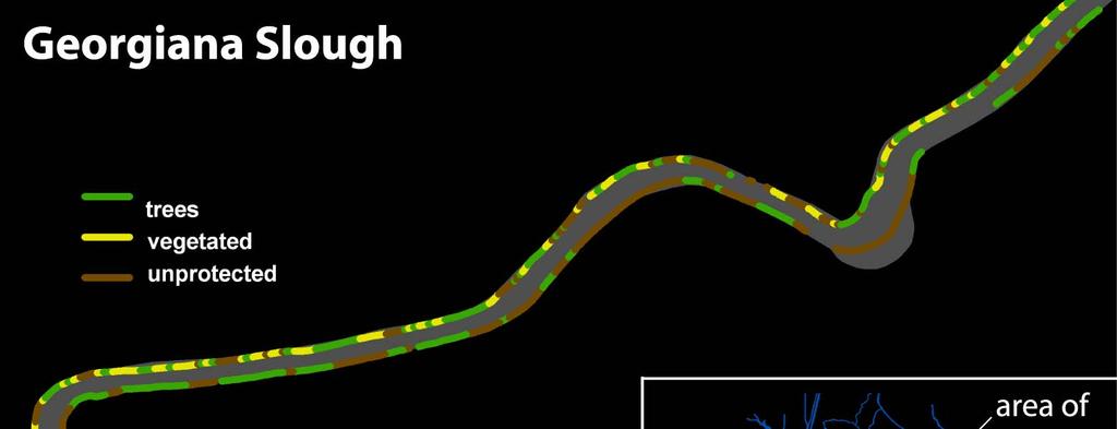
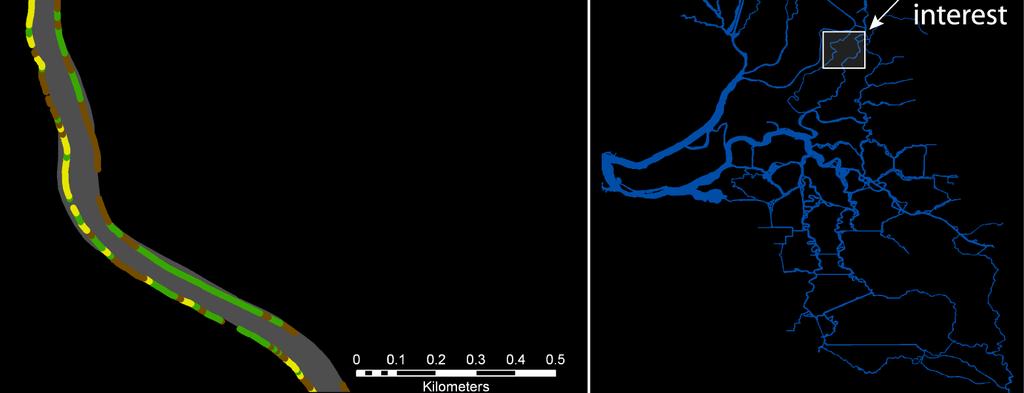
18 Mapping and Characterizing Levee Waterlines Map, with GPS, 800 Miles of Levee Waterline Categorize as 1 of 9 types Use as Indicator of Erosion Vulnerability


19 Selected Bank Types Partial Rock Partial Concrete Unprotected Trees Trees Trees Vegetation
20 800 Miles Of Bank Types
21 Summary of Bank Types Levee Bank Types by Length length (km) Partial Rock 75 mi 65 mi 50 mi Most Vulnerable To Erosion Partial Concrete Type Rock1 Type 3 Unprotected Type 7 Vegetated Type 6 Type Trees5 Developed Type 8 Type Concrete 2 Type Undet. 9 Type 4
22
23

24 Boat Wake (wind wave) Dissipation by Brush Bundles: Georgiana Slough Eroded Levee Brush Bundles

25 Experimental Design Outer PTs Inner PTs
26 Results: Brush Bundles Dissipate 60% of Boat Wake Energy 2.0 r 2 =0.031 p=0.442 CONTROL r 2 =0.578 p= r 2 =0.730 p=0.000 y=0.901x R 2 = 0.73 BUNDLE r 2 =0.101 p= E n E n Normalized h Normalized h
 and Dean (1979) Dissipation Function of Stem Size, Stand Density, Stand")
27 Boat Wake (wind wave) Dissipation by Tule Stands: Sacramento River Based on Concepts in Markel (1967) and Dean (1979) Dissipation Function of Stem Size, Stand Density, Stand Width
28 Dean s (1979) Model For Wave Attenuation H ( x) H 1 = 1 AH o + o x H 0 is offshore wave height x is distance from edge of stand A = C D 3πs D 2 s h C D is drag coefficient D s is stalk diameter s is stalk spacing h is water depth
29 Experimental Design Ten Data Runs of Five Boat Passes Each Wake Height Measured at 2 m Intervals Over 10 m Distance Tule Stand Thinned Between Runs Until Open Water Remained Measurements Compared to Dean Predictions Attenuation Ratio m m Distance in Stand
30 Observed vs. Predicted Wave Heights 0.19 Observed H (m) R 2 = Dean s Predicted H (m)
31 Summary of (Preliminary) Findings Average Erosion Rates for Unprotected Sites: HE = 0.13 m/yr and VE = 0.03 m/yr. Boat Wake Erosion Averages about 0.09 m/yr (or less). Annual Boat Traffic on Georgiana Slough > 3000 About 200 Miles of Levee Vulnerable to Boat Wake Erosion Brush Bundles Dissipate About 60% of Wake Energy Tule Stands Dissipate 15-30% of Wake Energy
Beach Profiles. Topics. Module 9b Beach Profiles and Crossshore Sediment Transport 3/23/2016. CE A676 Coastal Engineering
 Beach Profiles AND CROSS-SHORE TRANSPORT Orson P. Smith, PE, Ph.D., Professor Emeritus Topics Features of beach and nearshore profiles Equilibrium profiles Cross-shore transport References Text (Sorensen)
RESILIENCE THROUGH RESTORATION
 RESILIENCE THROUGH RESTORATION RECLAMATION DISTRICT NO. 1601 TWITCHELL ISLAND SAN JOAQUIN RIVER SETBACK LEVEE PROJECT TWITCHELL ISLAND BASICS Nearly 12 miles of levee Storm drainage facilities Protects
Leaning Into Adaptation
 www.marinslr.org Leaning Into Adaptation GFNMS Ocean Summit, May 17, 2016 Jack Liebster, Planning Manager, Marin County Marin County C-SMART Sea Level Rise Adaptation Process Evaluate Science Info. Implement
RE: Hurricane Matthew Beach Damage Assessment and Recommendations [CSE 2416]
![RE: Hurricane Matthew Beach Damage Assessment and Recommendations [CSE 2416]](/thumbs/83/87675702.jpg "RE: Hurricane Matthew Beach Damage Assessment and Recommendations [CSE 2416]") October 25, 2016 Iris Hill Town Administrator Town of Edisto Beach 2414 Murray St Edisto Beach SC 29438 RE: Hurricane Matthew Beach Damage Assessment and Recommendations [CSE 2416] Dear Iris, Hurricane
October 25, 2016 Iris Hill Town Administrator Town of Edisto Beach 2414 Murray St Edisto Beach SC 29438 RE: Hurricane Matthew Beach Damage Assessment and Recommendations [CSE 2416] Dear Iris, Hurricane
Estuarine Shoreline Stabilization
 Estuarine Shoreline Stabilization Property Owner s Guide to Determining the Most Appropriate Stabilization Method Estuarine shorelines are dynamic features that experience continued erosion. Land is lost
Coastal Sediment Transport Modeling Ocean Beach & San Francisco Bight, CA
 1 Coastal Sediment Transport Modeling Ocean Beach & San Francisco Bight, CA Honghai Li and Lihwa Lin Engineering Research and Development Center U.S. Army Corps of Engineers Frank Wu, Lisa Andes, and James
Cove Point Beach Restoration: Utilization of a Spawning Habitat by Horseshoe Crabs (Limulus polyphemus)
") Cove Point Beach Restoration: Utilization of a Spawning Habitat by Horseshoe Crabs (Limulus polyphemus) Paul Bushmann, Jessica Peterson, Bethany Enyeart and Deborah Smith Anne Arundel Community College
Cove Point Beach Restoration: Utilization of a Spawning Habitat by Horseshoe Crabs (Limulus polyphemus) Paul Bushmann, Jessica Peterson, Bethany Enyeart and Deborah Smith Anne Arundel Community College
April 7, Prepared for: The Caribbean Disaster Emergency Response Agency Prepared by: CEAC Solutions Co. Ltd.
 April 7, 2006 Prepared for: The Caribbean Disaster Emergency Response Agency Prepared by: Introduction CEAC Solutions Co. Ltd was commissioned in May 2005 to prepare coastal beach erosion hazard maps for
Council Agenda Report
 Agenda Item #10 Council Agenda Report SUBJECT: REVIEW, DISCUSS AND APPROVE LETTER TO THE CENTRAL VALLEY FLOOD PROTECTION BOARD REGARDING ISSUES WITH THE CENTRAL VALLEY FLOOD PROTECTION PLAN MEETING DATE:
3. Approximately how far will an object near Earth's surface fall in 3.0 seconds? m m m m
 Page 1 of 5 Sub work 10-10-02 Name 12-OCT-03 1. A car travels a distance of 98 meters in 10. seconds. What is the average speed of the car during this 10.-second interval? 1. 4.9 m/s 3. 49 m/s/ 2. 9.8
Mesoscale modeling of the productive capacity of fish habitats in the littoral zone of reservoirs
 Mesoscale modeling of the productive capacity of fish habitats in the littoral zone of reservoirs Mesoscale modeling of the productive capacity of fish habitats in the littoral zone of reservoirs General
Figure 4, Photo mosaic taken on February 14 about an hour before sunset near low tide.
 The Impact on Great South Bay of the Breach at Old Inlet Charles N. Flagg and Roger Flood School of Marine and Atmospheric Sciences, Stony Brook University Since the last report was issued on January 31
4/20/17. #31 - Coastal Erosion. Coastal Erosion - Overview
 Writing Assignment Due Monday by 11:59 pm #31 - Coastal Erosion Beach front property! Great View! Buy now at a great price! See main class web pages for detailed instructions Essays will be submitted in
Natural Bridges Field Trip Activity
 Natural Bridges Field Trip Activity This is due in class on MONDAY- March 1 - not in sections! Name TA: NOTE ON THE GRADING OF THIS ASSIGNMENT: Many of the questions below (especially in the tidepool part)
Wind Blow-out Hollow Generated in Fukiage Dune Field, Kagoshima Prefecture, Japan
 R. Nishi Wind Blow-out Hollow Generated in Fukiage Dune Field, Kagoshima Prefecture, Japan Ryuichiro Nishi, Li Elikson and Myokhin PREFACE A sand dune is vulnerable to severe waves and wind. Therefore,
Welcome to Paddle for the Edge!
 Welcome to Paddle for the Edge! Thank you for volunteering to conduct a survey of the Barnegat Bay s shorelines. As a citizen scientist, you become part of a project to collect critical data about current
Wave Prediction in the Santa Barbara Channel
 Wave Prediction in the Santa Barbara Channel OCS Study MMS 2001-055 Final Technical Summary Final Study Report U.S. Department of the Interior Minerals Management Service Pacific OCS Region Wave Prediction
Steelhead Society of BC. Thompson River Watershed Restoration and Enhancement Project #4 Nicola River Bank Stabilization and Enhancement Project
 Steelhead Society of BC Presents: Thompson River Watershed Restoration and Enhancement Project #4 Nicola River Bank Stabilization and Enhancement Project Application for Funding December 2013 1.0 BACKGROUND
Using sea bed roughness as a wave energy dissipater
 Island Sustainability II 203 Using sea bed roughness as a wave energy dissipater T. Elgohary 1, R. Elgohary 1 & M. Hagrass 2 1 Department of Civil Engineering (Irrigation and Hydraulic), The Tenth of Ramadan
CMS Modeling of the North Coast of Puerto Rico
 CMS Modeling of the North Coast of Puerto Rico PRESENTED BY: Dr. Kelly Rankin Legault, Ph.D., P.E. 1 Dr. Alfredo Torruella, Ph.D. 2 1 USACE Jacksonville District 2 University of Puerto Rico October 2016
Feasibility Study for Restoration of Titlow Lagoon Fish Passage. South Puget Sound Salmon Enhancement Group
 Feasibility Study for Restoration of Titlow Lagoon Fish Passage South Puget Sound Salmon Enhancement Group January 2010 Feasibility Study for Restoration of Titlow Lagoon Fish Passage Prepared for South
An Update of Coastal Erosion in Puerto Rico
 Jack Morelock and Maritza Barreto An Update of Coastal Erosion in Puerto Rico Department of Marine Sciences, University of Puerto Rico at Mayagüez and Geography Department, University of Puerto Rico at
Shoreline Erosion Control Failures and How To Avoid Them
 2008 Illinois Lake Management Association Shoreline Erosion Control Failures and How To Avoid Them by: Hank Sutton, President, Lake Rip Rap, Inc. www.lakeriprap.com - www.macoupinboats.com Setting the
Understanding the Tsunami Wave
 The First Tsunami attack on Sri Lanka Krakatoa Island 27 th August 1883 Understanding the Tsunami Wave Generation Propagation Nearshore Transformation Shoreline Entry Inland Dissipation 1 Generation and
Effect of Fluid Density and Temperature on Discharge Coefficient of Ogee Spillways Using Physical Models
 RESEARCH ARTICLE Effect of Fluid Density and Temperature on Discharge Coefficient of Ogee Spillways Using Physical Models M. SREENIVASULU REDDY 1 DR Y. RAMALINGA REDDY 2 Assistant Professor, School of
Northwest Hydraulic Consultants (NHC) is pleased to submit this assessment of the wave climate at Lazo Road, Comox.
 is pleased to submit this assessment of the wave climate at Lazo Road, Comox.") 405 495 Dunsmuir Street Nanaimo, B.C. V9R 6B9 250.754.6425 www.nhcweb.com NHC Ref. No. 03000276 21 November 2014 Wedler Engineering LLP #211-2459 Cousins Avenue Courtenay, BC V9N 3N6 Attention: Andrew
405 495 Dunsmuir Street Nanaimo, B.C. V9R 6B9 250.754.6425 www.nhcweb.com NHC Ref. No. 03000276 21 November 2014 Wedler Engineering LLP #211-2459 Cousins Avenue Courtenay, BC V9N 3N6 Attention: Andrew
ABSTRACT INTRODUCTION
 Sengupta, M. and Dalwani, R. (Editors). 2008 Proceedings of Taal2007: The 12 th World Lake Conference: 1022-1027 Water Erosion Control Using the Fetch Calculator. Applications for Constructed Wetlands
ANNUAL INSPECTION BY A QUALIFIED PROFESSIONAL ENGINEER ALL CCR IMPOUNDMENTS CCR Rule Section (b)
") ANNUAL INSPECTION BY A QUALIFIED PROFESSIONAL ENGINEER ALL CCR IMPOUNDMENTS ASBURY POWER PLANT 21133 Uphill Lane Asbury, Missouri 64832 January 18, 2019 LIBERTY UTILITIES Empire District Prepared by: Rachel
ANNUAL INSPECTION BY A QUALIFIED PROFESSIONAL ENGINEER ALL CCR IMPOUNDMENTS ASBURY POWER PLANT 21133 Uphill Lane Asbury, Missouri 64832 January 18, 2019 LIBERTY UTILITIES Empire District Prepared by: Rachel
San Joaquin River Restoration Program, 2013 Chinook Salmon Trap and Haul Summary
 San Joaquin River Restoration Program, 2013 Chinook Salmon Trap and Haul Summary Introduction The Hills Ferry Barrier (HFB) is constructed annually by California Department of Fish and Wildlife (CADFW)
Volume and Shoreline Changes along Pinellas County Beaches during Tropical Storm Debby
 Volume and Shoreline Changes along Pinellas County Beaches during Tropical Storm Debby Ping Wang and Tiffany M. Roberts Coastal Research Laboratory University of South Florida July 24, 2012 Introduction
CHAPTER 281 INFLUENCE OF NEARSHORE HARDBOTTOM ON REGIONAL SEDIMENT TRANSPORT
 CHAPTER 281 INFLUENCE OF NEARSHORE HARDBOTTOM ON REGIONAL SEDIMENT TRANSPORT Paul C.-P. Lin, Ph.D., P.E. 1 and R. Harvey Sasso, P.E. 2 ABSTRACT The influence of nearshore hardbottom on longshore and cross-shore
SFM mapping of coastal erosion at Point Woronzof. Gennady Gienko, PhD Department of Geomatics, UAA
 SFM mapping of coastal erosion at Point Woronzof Gennady Gienko, PhD Department of Geomatics, UAA ggienko@alaska.edu POINT WORONZOF Point Woronzof bluff 135 ft elevation Point Woronzof bluff Pt. Woronzof
2016 International Perforating Symposium May Galveston, Texas
 IMESAFR - QRA Tool Perforating Gun Safety Analysis 2016 International Perforating Symposium May 9-11 - Galveston, Texas Who is the Institute of Makers of Explosives? Safety and Security Association for
There are many different kinds of beaches which are generally characterized by the dominance of waves, tides, rivers and currents, and in particular
 Fig. 11-11, p. 253 There are many different kinds of beaches which are generally characterized by the dominance of waves, tides, rivers and currents, and in particular differ by the amount of energy, which
UPPER BEACH REPLENISHMENT PROJECT RELATED
 ASSESSMENT OF SAND VOLUME LOSS at the TOWNSHIP of UPPER BEACH REPLENISHMENT PROJECT RELATED to the LANDFALL OF HURRICANE SANDY - PURSUANT TO NJ-DR 4086 This assessment is in response to Hurricane Sandy
To: William Woods, Jenni Austin Job No: CentrePort Harbour Deepening Project - Comments on community queries
 Memo To: William Woods, Jenni Austin From: Richard Reinen-Hamill Date: Subject: cc: 1 Purpose This memo sets out our response to issues raised at and after Seatoun community consultation sessions held
Loads on Structures. Dead Load / Fixed Load Live Load / Imposed Load Earthquake Load Wind Load Snow Load
 Loads on Structures Dead Load / Fixed Load Live Load / Imposed Load Earthquake Load Wind Load Snow Load Characteristics of Wind Load Depends upon - velocity and density of the air height above ground level
Background. that may differ from the rest of the world.
 Background ¾Climate Change impacts in the Pacific very serious and will impact the lives and livelihoods of the people people. ¾Sea level rise is a major threat need to help reduce carbon emission. One
Wind waves drive multiple mechanisms of erosion of the marsh scarp in Barataria Bay, LA
 Wind waves drive multiple mechanisms of erosion of the marsh scarp in Barataria Bay, LA Kendall Valentine Giulio Mariotti Department of Oceanography and Coastal ciences, Louisiana tate University ite A
Southern California Beach Processes Study
 Southern California Beach Processes Study Torrey Pines Field Site 5th Quarterly Report 31 May 22 to California Resources Agency and California Department of Boating and Waterways R.T. Guza 1, W.C. O Reilly
SAN DIEGUITO WETLANDS RESTORATION PROJECT 08 JANUARY 2018 BEACH PROFILES CITY OF DEL MAR, CALIFORNIA. Data Report
 SAN DIEGUITO WETLANDS RESTORATION PROJECT 08 JANUARY 2018 BEACH PROFILES CITY OF DEL MAR, CALIFORNIA Data Report Prepared by Coastal Environments, Inc. 2166 Avenida de la Playa, Suite E La Jolla, CA 92037
CHAPTER 8 ASSESSMENT OF COASTAL VULNERABILITY INDEX
 124 CHAPTER 8 ASSESSMENT OF COASTAL VULNERABILITY INDEX 8.1 INTRODUCTION In order to assess the vulnerability of the shoreline considered under this study against the changing environmental conditions,
then extrapolated to larger area just based on the length of bank [that actually falls in this category].
![then extrapolated to larger area just based on the length of bank [that actually falls in this category].](/thumbs/73/69159506.jpg "then extrapolated to larger area just based on the length of bank [that actually falls in this category].") Ken Rood: Good morning, all. You'll probably be glad to know I'm the last speaker of the day. I'm never sure if that's a good thing or not. But [lucky me]. And I'm going to talk today -- the title of the
Ken Rood: Good morning, all. You'll probably be glad to know I'm the last speaker of the day. I'm never sure if that's a good thing or not. But [lucky me]. And I'm going to talk today -- the title of the
Predicting climate conditions for turbine performance
 Predicting climate conditions for turbine performance Mark Žagar, Vinay Belathur Krishna, Alvaro Matesanz Gil Vestas Data Engineering & Analytics / Advanced Plant Modelling Resource assessment, power curve,
UNDERWATER BRIDGE INSPECTION REPORT STRUCTURE NO CSAH NO. 7 OVER THE SNAKE RIVER DISTRICT 1 - PINE COUNTY
 UNDERWATER BRIDGE INSPECTION REPORT STRUCTURE NO. 58506 CSAH NO. 7 OVER THE SNAKE RIVER DISTRICT 1 - PINE COUNTY PREPARED FOR THE MINNESOTA DEPARTMENT OF TRANSPORTATION BY COLLINS ENGINEERS, INC. JOB NO.
Tracking Marsh Elevation and Water Levels in Elkhorn Slough January 2017
 Tracking Marsh Elevation and Water Levels in Elkhorn Slough January 2017 1931 Charlie Endris GIS Specialist Elkhorn Slough NERR Elkhorn Slough Foundation Central Coast Wetlands Group 2015 Questions Are
Energy Attenuation & Hybrid Living Shorelines: A Viable Tool for Coastal Resilience
 Energy & Hybrid Living Shorelines: A Viable Tool for Coastal Resilience Hot Topic Session Delaware Estuary Science & Environmental Summit Balancing Progress & Protection 10 Years of Science in Action January
Fish Passage Culvert Assessment for Cahilty Creek Watershed FIA Project #
 Fish Passage Culvert Assessment for Cahilty Creek Watershed FIA Project # 4602004 Prepared for Weyerhaeuser Company Ltd. Jason Ladyman R.P.F. 1550 Mission Flats Road PO Box 40 Kamloops BC V2C 5K3 Prepared
GIS Based Non-Motorized Transportation Planning APA Ohio Statewide Planning Conference. GIS Assisted Non-Motorized Transportation Planning
 The Purpose of GIS Assisted Network GIS Assisted Non-Motorized Transportation 2011 APA Ohio Statewide Conference Friday, 10:45 AM to Noon Focus on near-term projects wwwgreenwaycollabcom The purpose of
UNDERWATER BRIDGE INSPECTION REPORT DISTRICT 1 PINE COUNTY
 UNDERWATER BRIDGE INSPECTION REPORT STRUCTURE NO. 58551 CSAH NO. 41 OVER THE KETTLE RIVER DISTRICT 1 PINE COUNTY JULY 28, 2012 PREPARED FOR THE MINNESOTA DEPARTMENT OF TRANSPORTATION BY COLLINS ENGINEERS,
CROSS-SHORE SEDIMENT PROCESSES
 The University of the West Indies Organization of American States PROFESSIONAL DEVELOPMENT PROGRAMME: COASTAL INFRASTRUCTURE DESIGN, CONSTRUCTION AND MAINTENANCE A COURSE IN COASTAL DEFENSE SYSTEMS I CHAPTER
Dry Hydrants. The installation of a non-pressurized pipe system into local water sources provides a ready means of supplying water to fire engines.
 Dry Hydrants What is a Dry Hydrant? A dry hydrant is a non-pressurized pipe system permanently installed in existing lakes, ponds and streams that provides a suction supply of water to a fire department
Puget Sound Nearshore Ecosystem Restoration Project Restore America s Estuaries Conference 2012 Tampa, FL
 Restore America s Estuaries Conference 2012 Tampa, FL presented by: Theresa Mitchell, WA Dept. of Fish & Wildlife Nearshore General Investigation Change Analysis: Comparison of historical and current
Photo by: Darryl Hatheway, 2011
 Photo by: Darryl Hatheway, 2011 September 11, 2015 Presentation Discussion Examine PFD V-Zone Mapping in Wave Runup Dominated West Coast Application of PFD V-Zone Mapping Criteria in Pacific G&S PFD V-Zone
Activity #1: The Dynamic Beach
 Activity #1: The Dynamic Beach Beach Profiling By Betsy Sheffield, COASTeam Program, College of Charleston, Charleston, SC Subjects: Science, Math Skills: Analysis, description, listing, research, small
Jordan River Project Water Use Plan
 Jordan River Project Water Use Plan Monitoring Surfing Quality below the Jordan River Generating Station Implementation Year 5 Reference: JORMON-5 Study Period: March 5 to April 1, RRL Recreation Resources
Laboratory studies of water column separation
 IOP Conference Series: Materials Science and Engineering OPEN ACCESS Laboratory studies of water column separation To cite this article: R Autrique and E Rodal 2013 IOP Conf. Ser.: Mater. Sci. Eng. 52
Journal of Geophysical Research Earth Surface. Supporting Information for. A mechanistic model of waterfall plunge pool erosion into bedrock
 Journal of Geophysical Research Earth Surface Supporting Information for A mechanistic model of waterfall plunge pool erosion into bedrock Joel S. Scheingross 1 * and Michael P. Lamb 1 1 ivision of Geological
Flow in a shock tube
 Flow in a shock tube April 30, 05 Summary In the lab the shock Mach number as well as the Mach number downstream the moving shock are determined for different pressure ratios between the high and low pressure
A Scale Model Test on Hydraulic Resistance of Tunnel Elements during Floating Transportation
 Advanced Materials Research Online: 2014-04-17 ISSN: 1662-8985, Vols. 919-921, pp 841-845 doi:10.4028/www.scientific.net/amr.919-921.841 2014 Trans Tech Publications, Switzerland A Scale Model Test on
The Dynamic Coast. Right Place Resources. A presentation about the interaction between the dynamic coast and people
 The Dynamic Coast Houses threatened by coastal erosion in California Right Place Resources A presentation about the interaction between the dynamic coast and people For the rest of the presentations in
LOCALLY CONCENTRATED SEVERE BEACH EROSION ON SEISHO COAST CAUSED BY TYPHOON T0709
 F-4 Fourth International Conference on Scour and Erosion 2008 LOCALLY CONCENTRATED SEVERE BEACH EROSION ON SEISHO COAST CAUSED BY TYPHOON T0709 Yoshimitsu TAJIMA 1 and Shinji SATO 2 1 Member of JSCE, Associate
Figure79. Location map for the 10 NJBPN profile sites in Atlantic County, NJ 155
 154 Figure79. Location map for the 10 NJBPN profile sites in Atlantic County, NJ 155 ATLANTIC COUNTY SPRING 2009 to FALL 2010 The Atlantic County coastline consists of three barrier islands. Between Little
Monitoring Surfing Quality Below the Jordan River Generating Station (Year 3)
") Jordan River Water Use Plan Monitoring Surfing Quality Below the Jordan River Generating Station (Year 3) Reference: JORMON-5 Monitoring Surfing Quality Below the Jordan River Generating Station Study
Jordan River Water Use Plan Monitoring Surfing Quality Below the Jordan River Generating Station (Year 3) Reference: JORMON-5 Monitoring Surfing Quality Below the Jordan River Generating Station Study
Beach Restoration in Okaloosa and Walton Counties. FSBPA Technology Conference Clearwater, FL
 Beach Restoration in Okaloosa and Walton Counties FSBPA Technology Conference Clearwater, FL Presented by: Duncan Greer, E.I. February 5, 2015 PRESENTATION OUTLINE 1. Overview of Project Locations 2. Eglin
FACT SHEET MCGREGOR LAKE RESTORATION HABITAT PROJECT POOL 10, UPPER MISSISSIPPI RIVER, WISCONSIN ENVIRONMENTAL MANAGEMENT PROGRAM
 FACT SHEET MCGREGOR LAKE RESTORATION HABITAT PROJECT POOL 10, UPPER MISSISSIPPI RIVER, WISCONSIN ENVIRONMENTAL MANAGEMENT PROGRAM LOCATION McGregor Lake is located within a mid-river island in Pool 10
Analysis of the Interrelationship Among Traffic Flow Conditions, Driving Behavior, and Degree of Driver s Satisfaction on Rural Motorways
 Analysis of the Interrelationship Among Traffic Flow Conditions, Driving Behavior, and Degree of Driver s Satisfaction on Rural Motorways HIDEKI NAKAMURA Associate Professor, Nagoya University, Department
For Educational and Non-Profit Use Only!
 This flyer was originally created and published in Japanese by Shizuoka Prefecture, Japan. UNESCO IOC ITIC provides this English translation for portions of the original document with the kind permission
How an extreme wind atlas is made
 How an extreme wind atlas is made AC Kruger South African Weather Service X Larsén DTU Wind Energy Wind 1 Atlas for South Africa (WASA) Why do we need extreme wind statistics? Statistical background for
Coastal Hazards Study
 Coastal Hazards Study 2212 Beach Boulevard, Pacifica Prepared for: EXECUTIVE SUMMARY City of Pacifica 170 Santa Maria Ave Pacifica, CA 94044 Prepared by: moffatt & nichol 2185 N. California Blvd. Walnut
CYCLING TIME TRIALS The national governing body for CYCLING time trials
 The national governing body for CYCLING time trials www.ctt.org.uk SOUTH DISTRICT COUNCIL COURSE DETAILS FOR START SHEETS & RISK ASSESSMENT COURSE NUMBER P235/10 INDEX Guidance Notes for Event Promoters
Hydrographic Surveying Methods, Applications and Uses
 Definition: Hydrographic Surveying Methods, Applications and Uses It is the branch of surveying which deals with any body of still or running water such as a lake, harbor, stream or river. Hydrographic
2012 Susitna River Water Temperature and Meteorological Field Study
 (FERC No. 14241) 2012 Susitna River Water Temperature and Meteorological Field Study Appendix A Prepared for Prepared by URS Corporation Tetra Tech Inc. February 2013 APPENDIX A: PHOTOGRAPHS AND SITE INFORMATION
Climate Change Impacts to KSC Launch Complex
 Climate Change Impacts to KSC Launch Complex Presented to: 2010 International Workshop on Environment and Energy By: John Shaffer NASA Environmental Management Branch Kennedy Space Center Hurricane Season
ANNUAL INSPECTION BY A QUALIFIED PROFESSIONAL ENGINEER ALL CCR IMPOUNDMENTS CCR Rule Section (b)
") ANNUAL INSPECTION BY A QUALIFIED PROFESSIONAL ENGINEER ALL CCR IMPOUNDMENTS ASBURY POWER PLANT 21133 Uphill Lane Asbury, Missouri 64832 January 18, 2017 EMPIRE DISTRICT ELECTRIC COMPANY Prepared by: Rachel
ANNUAL INSPECTION BY A QUALIFIED PROFESSIONAL ENGINEER ALL CCR IMPOUNDMENTS ASBURY POWER PLANT 21133 Uphill Lane Asbury, Missouri 64832 January 18, 2017 EMPIRE DISTRICT ELECTRIC COMPANY Prepared by: Rachel
Culvert Design for Low and High Gradient Streams in the Midwest. Dale Higgins, Hydrologist Chequamegon-Nicolet National Forest
 Culvert Design for Low and High Gradient Streams in the Midwest Dale Higgins, Hydrologist Chequamegon-Nicolet National Forest Overview Culvert Design Considerations Hydraulic Terms Culvert Impacts Low
UNDERWATER BRIDGE INSPECTION REPORT DISTRICT 4 - OTTER TAIL COUNTY
 UNDERWATER BRIDGE INSPECTION REPORT STRUCTURE NO. L0885 TWP NO. 970 OVER THE OTTER TAIL RIVER DISTRICT 4 - OTTER TAIL COUNTY PREPARED FOR THE MINNESOTA DEPARTMENT OF TRANSPORTATION BY COLLINS ENGINEERS,
Follets Island Nearshore Beach Nourishment Project
 Coast & Harbor Engineering A division of Hatch Mott MacDonald Follets Island Nearshore Beach Nourishment Project Arpit Agarwal, P.E. April 1, 2016 Project Site!"#$% &'(% &)*+% )#,'-+% Shoreline Erosion
Five Counties Salmonid Conservation Program - Fish Passage Design Workshop. February 2013
 Program - Aquatic Organisms and Stream Crossings Ecological Connectivity A watershed is a network of channels that drain a common boundary. Channel characteristics formed by interaction of precipitation,
Eilat 's artificial lagoons project on the Red Sea - Israel R. Raviv Ir. R. Raviv, Coastal Engineering Ltd., P.O. Box 7322, z/b 37072,
 Eilat 's artificial lagoons project on the Red Sea - Israel R. Raviv Ir. R. Raviv, Coastal Engineering Ltd., P.O. Box 7322, z/b 37072, Introduction Eilat city is located in the southern part of the state
HOW FAST/FAR DOES FLY LINE FALL? N. Perkins of the University of Michigan, March 2003
 HOW FAST/FAR DOES FLY LINE FALL? N. Perkins of the University of Michigan, March 003 This report summarizes a simple model for the free fall dynamics of a length of fly line. The line is assumed to remain
Natural Shoreline Restoration for High Energy Shorelines. Brian Majka Restoration Ecologist 3/7/2019
 Natural Shoreline Restoration for High Energy Shorelines Brian Majka Restoration Ecologist 3/7/2019 Today we ll discuss: High energy shorelines Restoration techniques for high energy shorelines Project
OFFERING MEMORANDUM DUTRA S ISLAND RARE ISLAND WITH DEVELOPMENT POTENTIAL PRICE AVAILABLE UPON REQUEST
 OFFERING MEMORANDUM RARE ISLAND WITH DEVELOPMENT POTENTIAL DUTRA S ISLAND PRICE AVAILABLE UPON REQUEST Matt Hagar, CCIM CEO 925-380-9006 Matt@InteroWC.com #01896662 590 Ygnacio Valley Road Ste 102 Walnut
RURAL HIGHWAY SHOULDERS THAT ACCOMMODATE BICYCLE AND PEDESTRIAN USE (TxDOT Project ) June 7, Presented by: Karen Dixon, Ph.D., P.E.
 June 7, Presented by: Karen Dixon, Ph.D., P.E.") RURAL HIGHWAY SHOULDERS THAT ACCOMMODATE BICYCLE AND PEDESTRIAN USE (TxDOT Project 0-6840) June 7, 2016 Presented by: Karen Dixon, Ph.D., P.E., TTI Team: Kay Fitzpatrick, Raul Avelar, & Subasish Das Project
RURAL HIGHWAY SHOULDERS THAT ACCOMMODATE BICYCLE AND PEDESTRIAN USE (TxDOT Project 0-6840) June 7, 2016 Presented by: Karen Dixon, Ph.D., P.E., TTI Team: Kay Fitzpatrick, Raul Avelar, & Subasish Das Project
BUILDING CHINARAP. Zhang Tiejun Research Institute of Highway (RIOH) Beijing, China
 Beijing, China") BUILDING CHINARAP Zhang Tiejun Research Institute of Highway (RIOH) Beijing, China E-mail: tj.zhang@rioh.cn Greg Smith International Road Assessment Programme (irap) Beijing, China E-mail: greg.smith@irap.org
BUILDING CHINARAP Zhang Tiejun Research Institute of Highway (RIOH) Beijing, China E-mail: tj.zhang@rioh.cn Greg Smith International Road Assessment Programme (irap) Beijing, China E-mail: greg.smith@irap.org
MCCAW REACH RESTORATION
 Final Report MCCAW REACH FISH RESTORATION PHASE B Jack McCaw Inland Empire Action Coalition http://www.wwccd.net/ Phone: 509-956-3777 Hours: 8:00-4:30 Walla Walla County Conservation District Snake River
1. What are the differences and similarities among transverse, longitudinal, and surface waves?
 Assignment Waves Reading: Giancoli, Chapters 11, 12, 22, 24 Holt, Chapters 12, 14 Objectives/HW The student will be able to: 1 Define, apply, and give examples of the following concepts: wave, pulse vs.
A Preliminary Review of Beach Profile and Hardbottom Interactions
 A Preliminary Review of Beach Profile and Hardbottom Interactions Douglas W. Mann, P.E., D.CE. CB&I A World of Solutions Presentation Goal Lead to a better understanding of the challenges regarding the
Surface Firmness: Can we Manage it? Clint Waltz, Ph.D. Turfgrass Specialist
 Surface Firmness: Can we Manage it? Clint Waltz, Ph.D. Turfgrass Specialist Measuring Playability What affects play on a golf green? Speed Stimpmeter Long history Easily understandable units (feet) Management
COMPARISON OF ROCK SEAWALL AND DUNE FOR STORM DAMAGE REDUCTION
 COMPARISON OF ROCK SEAWALL AND DUNE FOR STORM DAMAGE REDUCTION Hyun Dong Kim 1, Nobuhisa Kobayashi 2, and Xavier Chávez Cárdenas 3 Four test series consisting of 14 tests and 140 runs (each run lasted
ASSESMENT of ESTIMATION MODELS for SCOUR AROUND PIPELINES under IRREGULAR WAVES
 ASSESMENT of ESTIMATION MODELS for SCOUR AROUND PIPELINES under IRREGULAR WAVES Burak Kiziloz 1 Esin Cevik 2 Yalcin Yuksel 3 and Burak Aydogan 4 This study focuses on scour around submarine pipelines exposed
TRENCH AND EXCAVATION COLLAPSE
 TRENCH AND EXCAVATION COLLAPSE A. GENERAL This guideline provides operational guidance at rescue incidents that involve the location, disentanglement and removal of victims from sub-surface trench and
Introduction to Waves & Sound
 Big Ideas Introduction to Waves & Sound Feb 3 8:43 AM 1 What is Periodic Motion periodic motion is.. Apr 1 7:34 AM 2 Two Experiments 1. Pendulum 2. Bouncy Weight Apr 1 7:34 AM 3 Apr 9 9:04 AM 4 Apr 20
Bob Battalio, PE Chief Engineer, ESA September 8, 2016
 RELATING FUTURE COASTAL CONDITIONS TO EXISTING FEMA FLOOD HAZARD MAPS Technical Methods Manual Bob Battalio, PE Chief Engineer, ESA September 8, 2016 FMA 2016 Sacramento, California DWR-OST-SIO PILOTING
The Challenge of Wave Scouring Design for the Confederation Bridge
 13: Coastal and Ocean Engineering ENGI.8751 Undergraduate Student Forum Faculty of Engineering and Applied Science, Memorial University, St. John s, NL, Canada MARCH 2013 Paper Code. (13 - walsh) The Challenge
Report from Embassy Visit to Copenhagen May David Arditti
 Report from Embassy Visit to Copenhagen May 2013 David Arditti Standard CPH cycle track, one-way 1.5 2m wide, 5cm above carriageway, 5cm below footway Basic one-way cycle track protected by car parking
Utilizing Vessel Based Mobile LiDAR & Bathymetry Survey Techniques for Survey of Four Southern California Breakwaters
 Utilizing Vessel Based Mobile LiDAR & Bathymetry Survey Techniques for Survey of Four Southern California Breakwaters Western Dredging Association: Pacific Chapter September 2012 Insert: Pipe Location
Energy and mass transfer in gas-liquid reactors.
 Energy and mass transfer in gas-liquid reactors. John M Smith School of Engineering (D2) University of Surrey, Guildford GU2 7XH, UK j.smith@surrey.ac.uk 1 Energy and mass transfer in gas-liquid reactors.
Chadbourne Dam Repair and Fish Barrier
 Chadbourne Dam Repair and Fish Barrier Final Report for the Western Native Trout Initiative Prepared by: Carol Endicott Yellowstone Cutthroat Trout Conservation Biologist Montana Fish, Wildlife & Parks
Nearshore Dredged Material Placement Pilot Study at Noyo Harbor, CA
 1 Nearshore Dredged Material Placement Pilot Study at Noyo Harbor, CA Noyo Cove N 2011 National Conference on Beach Preservation Technology 9-11, February 2011 Lihwa Lin, Honghai Li, Mitchell Brown US