Coastal Adaptation to Sea level Rise Patrick Cunningham
|
|
|
- Toby Hardy
- 5 years ago
- Views:
Transcription


1 Coastal Adaptation to Sea level Rise Patrick Cunningham 1
2 Table of Contents The COAST Team Blue Marble and COAST The COAST Approach Example Projects North Hampton, NH/ Portland, ME Ideas for Maine Municipalities Copyright 2013 Blue Marble Geographics 2
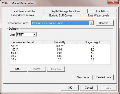
3 The COAST Approach: Cost-Benefit analysis to prepare for sea level rise and storm surge Copyright 2013 Blue Marble Geographics 3

4 October 2012 Copyright 2013 Blue Marble Geographics 4


5 Tuckerton, NJ Kennebunk, ME New York, NY Copyright 2013 Blue Marble Geographics 5

6 Copyright 2013 Blue Marble Geographics 6

7 Copyright 2013 Blue Marble Geographics 7

8 Do we want to be this guy? Copyright 2013 Blue Marble Geographics 8

9 Or this guy? Copyright 2013 Blue Marble Geographics 9
10 The Coast Team Copyright 2013 Blue Marble Geographics 10


11 Muskie School of Public Service University of Southern Maine Portland, Maine Samuel Merrill, PhD President COAST developer Paul Kirshen, PhD Senior Technical Consultant Climate Science Copyright 2013 Blue Marble Geographics 11


12 Environmental Finance Center Network Copyright 2013 Blue Marble Geographics 12

13 Copyright 2013 Blue Marble Geographics 13


14 Copyright 2013 Blue Marble Geographics 14


15 Twenty Years in Business 200,000 + Users, Every Country, Surveyors, GIS Analysts, Planners, Engineers, Students, Software Developers GIS Software Development The Geographic Calculator, Global Mapper, GeoCalc SDK, GeoCore SDK, and Global Mapper SDK Professional Services Training Copyright 2013 Blue Marble Geographics 15
16 What is COAST? COastal Adaptation to Sea level rise Tool Copyright 2013 Blue Marble Geographics 16

 Possible actions are complex.")
17 It is Difficult to Shift into Action Mode: 1) Consequences appear far off in time. 2) Cost-benefit relationships are ambiguous. 3) Possible actions are complex. 4) Doing nothing is far, far easier. Copyright 2013 Blue Marble Geographics 17
18 ECONOMIC SOCIAL ACTION POLITICAL Social + Political + Economic Factors = Force for Action Copyright 2013 Blue Marble Geographics 18
19 There are only four options: 1) Do nothing (usually = remain in denial) 2) Fortify assets 3) Accommodate higher water levels 4) Relocate assets Copyright 2013 Blue Marble Geographics 19
20 There are only four options: 1) Do nothing (usually = remain in denial) 2) Fortify assets 3) Accommodate higher water levels 4) Relocate assets >> COAST is a tool and approach to help evaluate costs and benefits of these options. Copyright 2013 Blue Marble Geographics 20

21 Copyright 2013 Blue Marble Geographics 21

22 Sister product Low cost GIS Software Supports 200+ Formats Copyright 2013 Blue Marble Geographics 22

23 Free Data (WMS, WFS, WMTS, etc) 3D Viewer Easy to Use and learn Copyright 2013 Blue Marble Geographics 23

24 Create or input elevation data Easily work with all types of LiDAR Edit and create attribute and geometries Copyright 2013 Blue Marble Geographics 24

25 Create or input elevation data Merge tax or value data with parcels Edit parcels layers Advance analysis tools Copyright 2013 Blue Marble Geographics 25

26
27 Data for Modeling Army Core of Engineers Depth Damage Functions (based on Flood and Insurance claim data) NOAA and Local tidal and storm data Sea level rise curves (from the literature and/or stakeholder selected) Vulnerable asset selection Adaptation action selection (from fortify/accomodate/relocate for that vulnerable asset) Assessors' Tables Geospatial data like LIDAR or other elevation layer, parcels, imagery, etc. Copyright 2013 Blue Marble Geographics 27
28 Copyright 2013 Blue Marble Geographics 28

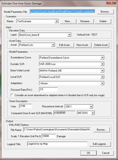
29 Some Project Sites Completed or Underway East Machias/Falmouth, Maine Old Orchard Beach, Maine Portland, Maine Hampton/Hampton Falls/Seabrook, New Hampshire Cambridge, Massachusetts Duxbury/Marshfield/Scituate, Massachusetts Groton/Mystic, Connecticut Kingston, New York Oxford, Maryland Copyright 2013 Blue Marble Geographics 29
30 Steps in the COAST Process 1. Engage stakeholders to select scenarios for sea level rise and storm surge. Copyright 2013 Blue Marble Geographics 30
31 Projection of Sea Level Rise from 1990 to 2100 Copyright 2013 Blue Marble Geographics 31 Vermeer and Rahmstorf (2009) Global sea level linked to global temperature. PNAS 106,
32 Use Local Data Connect with Peoples Experiences Copyright 2013 Blue Marble Geographics 32

33 Patriot s Day Storm 2007: York Beach, Maine Copyright 2013 Blue Marble Geographics 33


34 Copyright 2013 Blue Marble Geographics 34


35 Steps in the COAST Process 2. Select vulnerable asset. Norbert Psuty Michael Dwyer Copyright 2013 Blue Marble Geographics 35
36 Steps in the COAST Process 3. Input Depth-Damage Function. Depth (feet) Mean of Damage % % % % % % % Copyright 2013 Blue Marble Geographics 36
37 Steps in the COAST Process 4. Input Elevation Layer. Copyright 2013 Blue Marble Geographics 37
38 Results The model will estimate the dollar damage predicted for a particular-sized storm in a given year, in 3D maps Copyright 2013 Blue Marble Geographics 38
39 Example: Hampton, New Hampshire Copyright 2013 Blue Marble Geographics 39
40 COAST Results The model will then tell you the dollar damage predicted for a particular-sized storm in a given year, in 3D maps and calculate the cumulative expected damage from all predicted storms out to that year. Copyright 2013 Blue Marble Geographics 40
41 Next Steps in the COAST Process 5. Select candidate adaptation actions to protect from sea level rise and storm surge, staged over time, and estimate costs of each action. Copyright 2013 Blue Marble Geographics 41

42 Copyright 2013 Blue Marble Geographics 42

43 Pea Patch Island, DE (Delaware River) Copyright 2013 Blue Marble Geographics 43
44 Next Steps in the COAST Process 6. For each action, modify the DDF or the spatial distribution of the vulnerable asset to represent the effect of the action. Copyright 2013 Blue Marble Geographics 44
45 Next Steps in the COAST Process 7. Perform cumulative expected damage analysis on each action. Copyright 2013 Blue Marble Geographics 45
46 Next Steps in the COAST Process 8. Use maps and tables in public process. Copyright 2013 Blue Marble Geographics 46
47 Last Step in the COAST Process 9. Start Doing Something! Implement the Strategies, and Move the Needle off of Zero. Copyright 2013 Blue Marble Geographics 47
48 A Range of Vulnerable Assets: Economic output Public health impacts Displaced persons, vulnerable demographics Natural resources values Cultural resources values Community impacts Infrastructure (transportation, energy, facilities, telecommunications) Copyright 2013 Blue Marble Geographics 48
49 Possible Adaptation Actions: Hard or Soft Revetments Sea walls Jetties Levees Subway tunnel plugs Automatic floodgates Geotextile tubes Beach nourishment Dry flood-proofing Wet flood-proofing Increasing freeboard (now or later) Zoning changes Rolling easements Buyouts Copyright 2013 Blue Marble Geographics 49
50 Other Adaptive Actions Copyright 2013 Blue Marble Geographics 50

51 Copyright 2013 Blue Marble Geographics 51

52 Copyright 2013 Blue Marble Geographics 52

53 Copyright 2013 Blue Marble Geographics 53

54 Copyright 2013 Blue Marble Geographics 54

55 Copyright 2013 Blue Marble Geographics 55

56 Copyright 2013 Blue Marble Geographics 56

57 Joint Proposal: Catalysis Adaptation Partners with Parsons Brinckerhoff Establishing the Proper Design Height of Protection Measures For the NYCT 207 th Street Yard Copyright 2013 Blue Marble Geographics 57
 Probabilities of Surge Levels ( How many feet should be added to the normal tide height?) Predictions of Sea Level Rise into the Future (2042, 2062 or 2100?")
58 Setting of Design Height must take into account: Probabilities of Tidal Stage when Surge Occurs during the Tidal Cycle (At high or low tide?) Probabilities of Surge Levels ( How many feet should be added to the normal tide height?) Predictions of Sea Level Rise into the Future (2042, 2062 or 2100?) Design Life of the Protection Measure (30, 50 or 100 years?) Value of Protected Assets and Avoided Cumulative Expected Damages over Design Life The COAST tool applied by Catalysis Adaptation Partners will insure that costs for various protection heights are weighed against probabilities of flood heights and costs of predicted damages, including each of these factors. Copyright 2013 Blue Marble Geographics 58
59 North Hampton, NH Coastal Area 59
60 North Hampton, NH Selected Public Assets and Thresholds Asset 100 Yr. High SLR Low SLR Flood Seabrook WW Treatment Plant 9.8 now now Hampton WW Treatment Plant 9.8 now now Hampton Police Station 8.2 now now Hampton Sewage Pump Station 6.6 now now Seabrook Middle/Elem. School 14.8 ~2080 >2100 Hampton High School 23.0 >2100 >2100 NextEra Nuclear Power Plant 19.7 >2100 >

61 2100, High SLR, 100-year storm.cost from SLR Copyright 2013 Blue Marble Geographics 61
62 Example: Hampton, New Hampshire Copyright 2013 Blue Marble Geographics 62

63 Copyright 2013 Blue Marble Geographics 63

64 Copyright 2013 Blue Marble Geographics 64

65 $46.5 Copyright 2013 Blue Marble Geographics 65
66 Portland, ME Back Cove, Area 66

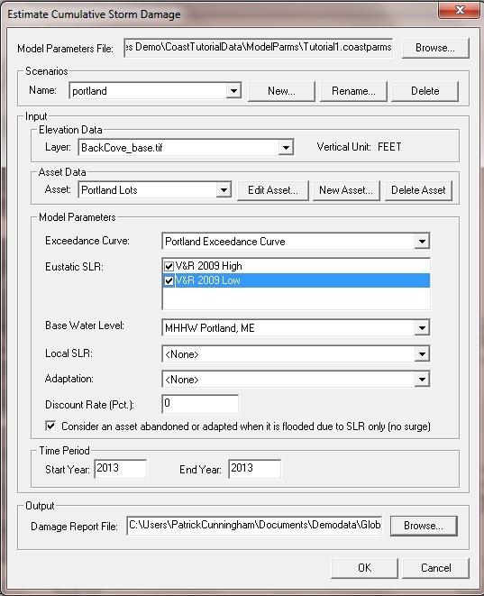
67 Back Cove, Portland Maine 67

68 2100, high sea level rise and mean higher high water 68
 Whole Foods1/9/10 at")
69 (R. Obrey.) Whole Foods1/9/10 at high tide 69

70 70

71 The Old Port, 10/11 at high tide (M. Craig) 71

72 72

73 Marginal Way and Cove St., 9/10, New Moon J. Piribeck 73

74 Marginal Way and Cove St., 9/10, New Moon J. Piribeck 74

75 The Old Port, 3/10 at high tide (D. Yakovleff) 75
76 Now the Portland Case: The four options: 1) Do nothing 2) Fortify assets 3) Relocate assets 4) Accommodate higher water levels 76
77 77

78 Copyright 2013 Blue Marble Geographics 78
 Global sea level linked to global temperature.")
79 Sea Level Change (inches) Projection of Sea Level Rise from 1990 to Copyright 2013 Blue Marble Geographics 79 Vermeer and Rahmstorf (2009) Global sea level linked to global temperature. PNAS 106,

80 2050, low sea level rise, 10 year storm Copyright 2013 Blue Marble Geographics 80

81 2050, high sea level rise, 100 year storm Copyright 2013 Blue Marble Geographics 81

82 2050, high sea level rise, 100 year storm COAST ASSET DATA Flood Depth = ft Estimated Damage = $9,850,023 FEATURE ATTRIBUTES LAYER = Unknown Area Type ELEVATION = OBJECTID_2 = 1 OBJECTID = 1369 Id = 0 CBL = 023 E002 LEAD_CBL = 023 E002 no_cbl = cbl Shape_Leng = dissolve = 0 Shape_Le_1 = OBJECTID_3 = 5336 ID_1 = HTEACCT = 3376 CBL_1 = 023 E LANDID = DESC_ = BUILDING VALUE YEAR = 12 PRIORITY = 2 VALUE = EXEMPT = GISCBL = 023 E002 ADJ_CURVAL = ADJ_VALUE = ADJUSTMENT = current value + 103,400 sq. ft * $127.10/sq. ft GISCBL_1 = 023 E002 PARID = 023 E GISCBL_12 = 023 E002 BLDG_DESC = RETAIL - MULTI OCCUPANCY BLDG_CLASS = 2 BASEMENT = STORIES = 0 Shape_Le_2 = Shape_Le_3 = Shape_Area = Copyright 2013 Blue Marble Geographics 82
83 Back Cove, Portland, Maine Adaptation Costs and Cumulative Expected Damages, through SLR Scenario Adaptation Damages Adaptation Cost Total Cost & Damage Percent from SLR Only No SLR No Action $373,814,977 $0 $373,814, % No SLR Back Cove Levee $3,595,485 $103,000,000 $106,595, % V&R 2009 High No Action $436,335,109 $0 $436,335, % V&R 2009 High Back Cove Levee $8,169,001 $103,000,000 $111,169, % V&R 2009 Low No Action $405,435,010 $0 $405,435, % V&R 2009 Low Back Cove Levee $5,643,428 $103,000,000 $108,643, % Copyright 2013 Blue Marble Geographics 83

84 2100, low sea level rise, 10 year storm Copyright 2013 Blue Marble Geographics 84

85 2100, high sea level rise, 100 year storm Copyright 2013 Blue Marble Geographics 85
86 Back Cove, Portland, Maine Adaptation Costs and Cumulative Expected Damages, through SLR Scenario Adaptation Damages Adaptation Cost Total Cost & Damage Percent from SLR Only No SLR No Action $868,893,372 $0 $868,893, % No SLR Back Cove Levee $8,719,621 $103,000,000 $111,719, % V&R 2009 High No Action $1,134,925,448 $0 $1,134,925, % V&R 2009 High Back Cove Levee $102,291,952 $103,000,000 $205,291, % V&R 2009 Low No Action $1,077,527,562 $0 $1,077,527, % V&R 2009 Low Back Cove Levee $27,255,870 $103,000,000 $130,255, % Copyright 2013 Blue Marble Geographics 86
87 Elsewhere in Maine Under discussion 87

88 Copyright 2013 Blue Marble Geographics 88
 Martin")

89 Machias Bridge, Machias (pressure transducer placed in 8/11) Martin s Point Bridge, Falmouth Copyright 2013 Blue Marble Geographics 89

90 Copyright 2013 Blue Marble Geographics 90

91 Copyright 2013 Blue Marble Geographics 91 R. Faunce

92 Copyright 2013 Blue Marble Geographics 92 R. Faunce

93 Copyright 2013 Blue Marble Geographics 93 R. Faunce

94 Copyright 2013 Blue Marble Geographics 94 R. Faunce

95 Copyright 2013 Blue Marble Geographics 95 R. Faunce

96 Copyright 2013 Blue Marble Geographics 96

97 Copyright 2013 Blue Marble Geographics 97 R. Faunce

98 Copyright 2013 Blue Marble Geographics 98 R. Faunce

99 Copyright 2013 Blue Marble Geographics 99


100 Coastal Adaptation to Sea level Rise Do Something, Move the Needle off of Zero Copyright 2013 Blue Marble Geographics 100
101 Coastal Adaptation to Sea level Rise Patrick Cunningham 101
Municipal Adaptation to Sea Level Rise in Saco Bay, Ogunquit, and Seabrook
 Municipal Adaptation to Sea Level Rise in Saco Bay, Ogunquit, and Seabrook Changing Environments Symposium Bowdoin College October 24, 2009 Climate Change Adaptation Panel 1:45 to 3:00 PM Jonathan T. Lockman,
Collaboration: Sea-level Marin Adaptation Response Team (C-SMART)
") Collaboration: Sea-level Marin Adaptation Response Team (C-SMART) Photo Credit : Lighthawk Aerial Community Development Agency 3501 Civic Center Drive, Rm. 308 San Rafael, CA 94903 415 4736269 T www.marinslr.org
Collaboration: Sea-level Marin Adaptation Response Team (C-SMART) Photo Credit : Lighthawk Aerial Community Development Agency 3501 Civic Center Drive, Rm. 308 San Rafael, CA 94903 415 4736269 T www.marinslr.org
Leaning Into Adaptation
 www.marinslr.org Leaning Into Adaptation GFNMS Ocean Summit, May 17, 2016 Jack Liebster, Planning Manager, Marin County Marin County C-SMART Sea Level Rise Adaptation Process Evaluate Science Info. Implement
VENICE LOCAL COASTAL PROGRAM UPDATE: COASTAL HAZARDS WELCOME
 VENICE LOCAL COASTAL PROGRAM UPDATE: COASTAL HAZARDS WELCOME 1 Introducing the Team Hosted by the Department of City Planning and grant funded in part by the California Coastal Commission 2 Workshop Purpose
SUPPLEMENTAL DOCUMENT SEA LEVEL RISE SCENARIO SELECTION AND DESIGN TIDE CALCULATION
 SUPPLEMENTAL DOCUMENT SEA LEVEL RISE SCENARIO SELECTION AND DESIGN TIDE CALCULATION FOR THE GUIDANCE FOR INCORPORATING SEA LEVEL RISE INTO CAPITAL PLANNING IN SAN FRANCISCO: ASSESSING VULNERABILITY AND
SPO Regional Challenge Grant Creation of a Sea Level Adaption Working Group for Biddeford, Saco, OOB and Scarborough J.T. Lockman, AICP, Planning
 SPO Regional Challenge Grant Creation of a Sea Level Adaption Working Group for Biddeford, Saco, OOB and Scarborough J.T. Lockman, AICP, Planning Director Southern Maine Regional Planning Commission jlockman@smrpc.org
City of Del Mar Local Coastal Plan (LCP) Amendment for Sea Level Rise and Coastal Flooding
 Amendment for Sea Level Rise and Coastal Flooding") City of Del Mar Local Coastal Plan (LCP) Amendment for Sea Level Rise and Coastal Flooding 6/22/17 Presentation to Sea Level Rise Stakeholder- Technical Advisory Committee (STAC) Nick Garrity, P.E. Lindsey
City of Del Mar Local Coastal Plan (LCP) Amendment for Sea Level Rise and Coastal Flooding 6/22/17 Presentation to Sea Level Rise Stakeholder- Technical Advisory Committee (STAC) Nick Garrity, P.E. Lindsey
SACO RIVER AND CAMP ELLIS BEACH SACO, MAINE SECTION 111 SHORE DAMAGE MITIGATION PROJECT APPENDIX F ECONOMIC ASSESSMENT
 SACO RIVER AND CAMP ELLIS BEACH SACO, MAINE SECTION 111 SHORE DAMAGE MITIGATION PROJECT APPENDIX F ECONOMIC ASSESSMENT Department of the Army New England District, Corps of Engineers 696 Virginia Road
Boothbay Harbor Rotary Club May 12, 2016
 Mapping Potential Sea Level Rise and Storm Surge in Boothbay Harbor, ME Boothbay Harbor Rotary Club May 12, 2016 Peter A. Slovinsky, Marine Geologist Maine Geological Survey S.M. Dickson, MGS Quickly,
Sea-Level Rise and Coastal Habitats in Southeastern Louisiana An Application of the SLAMM Model
 Sea-Level Rise and Coastal Habitats in Southeastern Louisiana An Application of the SLAMM Model Patty Glick (National Wildlife Federation) Jonathan Clough (Warren Pinnacle Consulting, Inc.) Amy Polaczyk
Sea Level Rise in South Florida: Causes, Consequences and Opportunities
 Sea Level Rise in South Florida: Causes, Consequences and Opportunities Dr. Todd A. Crowl Director, Institute of Water & the Environment Director, Southeast Environmental Research Center Co-Founder, Sea
LOCAL COASTAL PROGRAM UPDATE
 LOCAL COASTAL PROGRAM UPDATE Agenda Meeting #1 General Information (1 1:45 pm) Introductions and Background Grants involved What is a Local Coastal Program? What is required? LCP Update tasks and schedule
ADAPTATION TO SEA LEVEL RISE AND COASTAL IMPACTS
 ADAPTATION TO SEA LEVEL RISE AND COASTAL IMPACTS Miramar Inn, Half Moon Bay, March 1, 2014 Photo by Jack Sutton, all rights reserved 2/22/17 AdaptLA Workshop California Coastal Commission 2 Plans and regulates
ALTERNATIVES FOR COASTAL STORM DAMAGE MITIGATION AND FUNCTIONAL DESIGN OF COASTAL STRUCTURES
 The University of the West Indies Organization of American States PROFESSIONAL DEVELOPMENT PROGRAMME: COASTAL INFRASTRUCTURE DESIGN, CONSTRUCTION AND MAINTENANCE A COURSE IN COASTAL DEFENSE SYSTEMS I CHAPTER
U.S. Army Engineer Institute for Water Resources
 Sea Level Change Curve Calculator (2014.88) (DRAFT) U.S. Army Engineer Institute for Water Resources Table of Contents 1. INTRODUCTION... 2 1.1 BACKGROUND... 2 1.1.1 INFORMATION QUALITY ACT... 2 1.2 OVERVIEW...
Sea Level Rise and Coastal Flooding Why Waves Matter!
 Sea Level Rise and Coastal Flooding Why Waves Matter! Jason D. Burtner Massachusetts Office of Coastal Zone Management South Shore Regional Coordinator Sea Level Rise and Coastal Storm Damage and Flooding
North Shore of Long Island, Feasibility Study
 North Shore of Long Island, Asharoken New York Asharoken, Feasibility Study Asharoken, NY Public Meeting June 30, 2015 US Army Corps of Engineers US Army Corps of Engineers New York BUILDING STRONG BUILDING
CITY OF CAMBRIDGE 2015 BICYCLE PLAN TOWARDS A BIKABLE FUTURE
 CITY OF CAMBRIDGE 2015 BICYCLE PLAN TOWARDS A BIKABLE FUTURE WHICH FUTURE? CAMBRIDGE MUNICIPAL POLICIES 1992: Vehicle Trip Reduction Ordinance 1998: Parking & Transportation Demand Ordinance 2002: Climate
Climate Change and Security:
 Climate Change and Security: Ideas & Inspiration from Annapolis Angela Schedel, CDR, U.S. Navy Assistant Professor, U.S. Naval Academy Presented on September 13, 2016 at USFSP icar Workshop Disclaimer
Presentation Summary Why Use GIS for Ped Planning? What Tools are Most Useful? How Can They be Applied? Pedestrian GIS Tools What are they good for?
 1 2 Pedestrian GIS Tools What are they good for? Pro Walk / Pro Bike 2006 Presentation Summary Why Use GIS for Ped Planning? What Tools are Most Useful? How Can They be Applied? Matt Haynes Fehr & Peers
Taranaki Tsunami Inundation Analysis. Prepared for Taranaki Civil Defence Emergency Management Group. Final Version
 Taranaki Tsunami Inundation Analysis Prepared for Taranaki Civil Defence Emergency Management Group Final Version June 2012 AM 12/07 HBRC Plan Number 4362 Asset Management Group Technical Report Prepared
Bob Battalio, PE Chief Engineer, ESA September 8, 2016
 RELATING FUTURE COASTAL CONDITIONS TO EXISTING FEMA FLOOD HAZARD MAPS Technical Methods Manual Bob Battalio, PE Chief Engineer, ESA September 8, 2016 FMA 2016 Sacramento, California DWR-OST-SIO PILOTING
New Orleans Municipal Yacht Harbor
 New Orleans Municipal Yacht Harbor Marina Schematic Design Update 601 Poydras St., Suite 1860 New Orleans, LA, 70130 504-648-3560 Post-Katrina Municipal Yacht Harbor: Introduction The MYH was an approximate
ALTERNATIVES FOR COASTAL STORM DAMAGE MITIGATION
 ALTERNATIVES FOR COASTAL STORM DAMAGE MITIGATION Dave Basco Old Dominion University, Norfolk, Virginia, USA National Park Service Photo STRUCTURAL (changes to natural, physical system) hardening (seawalls,
SAN MATEO COUNTY SEA LEVEL RISE INITIATIVE
 SAN MATEO COUNTY SEA LEVEL RISE INITIATIVE OCEAN CLIMATE SUMMIT // MAY 17, 2016 Photo by Biking Nikon SF, all rights reserved San Mateo County has $24 billion in assets at risk from sea level rise Pacifica
INTRODUCTION TO COASTAL ENGINEERING
 The University of the West Indies Organization of American States PROFESSIONAL DEVELOPMENT PROGRAMME: COASTAL INFRASTRUCTURE DESIGN, CONSTRUCTION AND MAINTENANCE A COURSE IN COASTAL DEFENSE SYSTEMS I CHAPTER
NYS Coastal Waters. Water Resources of NYS: THE NATURE of the COASTAL ZONE. NYS Coastal Waters. NYS Coastal Atlas. Coastal Zone Management 10/10/2014
 Water Resources of NYS: THE NATURE of the COASTAL ZONE NYS Coastal Waters NYS is the only state to border the Atlantic Ocean and the Great Lakes (Lakes Erie and Ontario). Great Lakes shoreline: 577 miles
Town of Duck, North Carolina
 Tracking No. 00.00.2010 Erosion Mitigation And Shoreline Management Feasibility Study Town of Duck, North Carolina Coastal Planning & Engineering of North Carolina August 15, 2012 Tom Jarrett Robert Neal
City of West Des Moines PAVEMENT MANAGEMENT SYSTEM
 City of West Des Moines PAVEMENT MANAGEMENT SYSTEM 12/11/2018 Municipal Street Seminar (11-14-2018) JEFF NASH 1 City Background Information: - West Des Moines current census Population is around 66,000
Coastal Inundation. An Overview for TCDC
 Coastal Inundation An Overview for TCDC Rick Liefting Team Leader Regional Hazards and Environmental Compliance Integrated Catchment Management Waikato Regional Council Photo: Sugar Loaf Wharf, Coromandel.
Flood damage modelling
 Flood damage modelling Laurens Bouwer (dept. of Flood Risk Management) with Dennis Wagenaar, Andreas Burzel, Kymo Slager, Karin de Bruijn, Marcel van der Doef, and many others Introduction Why model flood
Estimation of damages caused by storm tides in the city of Hamburg K.-H. Pöschke DHI-WASY GmbH Waltersdorfer Str. 105, Berlin, Germany
 Estimation of damages caused by storm tides in the city of Hamburg K.-H. Pöschke DHI-WASY GmbH Waltersdorfer Str. 105, 12526 Berlin, Germany 1 Introduction The city of Hamburg is potentially endangered
APPENDIX D-2. Sea Level Rise Technical Memo
 APPENDIX D-2 Sea Level Rise Technical Memo 2185 N. California Blvd., Suite 500 Walnut Creek, CA 94596 (925) 944-5411 Fax: (925) 944-4732 www.moffattnichol.com DRAFT MEMORANDUM To: From: Neil Nichols,
SURGE SUPPRESSION ACHIEVED BY DIFFERENT COASTAL SPINE (IKE DIKE) ALIGNMENTS. Bruce A. Ebersole, Thomas W. Richardson and Robert W.
 ALIGNMENTS. Bruce A. Ebersole, Thomas W. Richardson and Robert W.") SURGE SUPPRESSION ACHIEVED BY DIFFERENT COASTAL SPINE (IKE DIKE) ALIGNMENTS Abstract Bruce A. Ebersole, Thomas W. Richardson and Robert W. Whalin, Jackson State University, Jackson, Mississippi The primary
SURGE SUPPRESSION ACHIEVED BY DIFFERENT COASTAL SPINE (IKE DIKE) ALIGNMENTS Abstract Bruce A. Ebersole, Thomas W. Richardson and Robert W. Whalin, Jackson State University, Jackson, Mississippi The primary
THE CHALLENGES OF A LARGE-AREA BATHYMETRIC SURVEY
 THE CHALLENGES OF A LARGE-AREA BATHYMETRIC SURVEY Agenda: - Introduction - Tender - Project Planning - Survey - Processing - Delivery - Conclusion 2 Introduction We know less of the oceans at our feet,
EXISTING AND PLANNED STRATEGIES AND ACTIONS CONNECTED WITH COASTAL PROTECTION IN ASPECT OF PREDICTED SEA LEVEL RISE
 EXISTING AND PLANNED STRATEGIES AND ACTIONS CONNECTED WITH COASTAL PROTECTION IN ASPECT OF PREDICTED SEA LEVEL RISE Andrzej Cieślak Long term coastal protection strategy In 2000 a new 1 Polish long term
Building Coastal Resiliency at Plymouth Long Beach
 Building Coastal Resiliency at Plymouth Long Beach Department of Marine and Environmental Affairs March 30, 2017 Introducing Green Infrastructure for Coastal Resiliency Plymouth Long Beach & Warren s Cove
Rochester Area Bike Sharing Program Study
 roc bike share Rochester Area Bike Sharing Program Study Executive Summary ~ January 2015 JANUARY 2015 8484 Georgia Avenue, Suite 800 Silver Spring, MD 20910 3495 Winton Pl., Bldg E, Suite 110 Rochester,
Some Steps Towards Climate-Ready Management of U.S. Fisheries
 Some Steps Towards Climate-Ready Management of U.S. Fisheries Roger Griffis 1, Wendy Morrison 1, Mark Nelson 1, Jon Hare 2, Valerie Termini 3 1 NOAA National Marine Fisheries Service, Silver Spring, MD,
CHAPTER 8 ASSESSMENT OF COASTAL VULNERABILITY INDEX
 124 CHAPTER 8 ASSESSMENT OF COASTAL VULNERABILITY INDEX 8.1 INTRODUCTION In order to assess the vulnerability of the shoreline considered under this study against the changing environmental conditions,
TOWARDS A BIKE-FRIENDLY CANADA A National Cycling Strategy Overview
 TOWARDS A BIKE-FRIENDLY CANADA A National Cycling Strategy Overview NationalCyclingStrategFrameworkv3.indd 1 Potential for this modal shift can be found in municipalities of all sizes, in every population
Citrus, Hernando, and Pasco Coastal Hazard Analysis. Flood Risk Review Meeting Citrus, Hernando, and Pasco Counties, Florida December 14, 2017
 Citrus, Hernando, and Pasco Coastal Hazard Analysis Flood Risk Review Meeting Citrus, Hernando, and Pasco Counties, Florida December 14, 2017 Introductions Risk MAP Project Team FEMA Region IV RAMPP (study
SEA LEVEL RISE IMPACT ASSESSMENT AND MITIGATION ALTERNATIVES DEVELOPMENT FOR BALBOA ISLANDS, CITY OF NEWPORT BEACH, CALIFORNIA
 SEA LEVEL RISE IMPACT ASSESSMENT AND MITIGATION ALTERNATIVES DEVELOPMENT FOR BALBOA ISLANDS, CITY OF NEWPORT BEACH, CALIFORNIA Ying Poon 1, Brett Sanders 2, Randy Mason 3 and Robert Stein 4 The City of
Climate Change Impacts to KSC Launch Complex
 Climate Change Impacts to KSC Launch Complex Presented to: 2010 International Workshop on Environment and Energy By: John Shaffer NASA Environmental Management Branch Kennedy Space Center Hurricane Season
NORTHERN CELL OPTIONS SHORTLIST RECOMMENDATIONS
 OPTIONS SHORTLIST RECOMMENDATIONS Coastal Unit C: Bayview Options recommended for MCDA scoring. Status quo. Planting 3. Renourishment (gravel) 6. Beach-scraping 7. Restore shingle crest. Inundation accommodation
Nearshore Dredged Material Placement Pilot Study at Noyo Harbor, CA
 1 Nearshore Dredged Material Placement Pilot Study at Noyo Harbor, CA Noyo Cove N 2011 National Conference on Beach Preservation Technology 9-11, February 2011 Lihwa Lin, Honghai Li, Mitchell Brown US
Update June 2018 OUR 2017 PUBLIC ENGAGEMENT
 Update June 2018 Hi, Let s Get Wellington Moving (LGWM) is developing a Recommended Programme of Investment (RPI) that meets our programme objectives and supports the city s and region s growth. As part
County of Santa Barbara Permit Option Analysis Goleta Beach JULY 13, 2017
 County of Santa Barbara Permit Option Analysis Goleta Beach JULY 13, 2017 Introduction 2 Goleta Beach Park welcomes 1.5 million visitors annually Amenities include: Picnic Areas and Group Areas w/bbqs
The Sand Beaches of New Hampshire and Maine
 The Sand Beaches of New Hampshire and Maine Beach Preservation and Erosion Control Photographs provided by Joe Kelly and Steve Adams Cover photo: Reid State Park, ME Introduction The sand beaches of New
TOWN OF PORTLAND, CONNECTICUT COMPLETE STREETS POLICY
 TOWN OF PORTLAND, CONNECTICUT COMPLETE STREETS POLICY I. VISION, GOALS & PRINCIPLES VISION To improve the streets of Portland making them safer and more accessible for all users including pedestrians,
The Ike Dike. A Coastal Barrier Protecting the. Hurricane Storm Surge. Protecting the Houston/Galveston Region from Hurricane Storm Surge
 The Ike Dike A Coastal Barrier Protecting the Houston/Galveston A Coastal Barrier Region from Hurricane Storm Surge Protecting the Houston/Galveston Region from Hurricane Storm Surge The Houston/Galveston
TITLE: North Carolina s Changing Shorelines. KEYWORDS: erosion - shorelines - mapping - sustainability
 UNC Coastal Studies Institute Teacher Resources 1 TITLE: North Carolina s Changing Shorelines KEYWORDS: erosion - shorelines - mapping - sustainability Changing shorelines impact coastal infrastructure.
Evaluation of June 9, 2014 Federal Emergency Management Agency Flood Insurance Study for Town of Weymouth, Norfolk, Co, MA
 Evaluation of June 9, 2014 Federal Emergency Management Agency Flood Insurance Study for Town of Weymouth, Norfolk, Co, MA Prepared For: Woodard & Curran 95 Cedar Street, Suite 100 Providence, RI 02903
DELAWARE S VULNERABLE COASTAL AREAS. DELAWARE INLAND BAYS and DELAWARE BAY RECONNAISSANCE STUDY
 DELAWARE S VULNERABLE COASTAL AREAS and the DELAWARE INLAND BAYS and DELAWARE BAY RECONNAISSANCE STUDY Kimberly K. McKenna, PG Delaware Dept. of Natural Resources & Environmental Control Division of Watershed
Atlantic Striped Bass Draft Addendum V. Atlantic Striped Bass Board May 9, 2017
 Atlantic Striped Bass Draft Addendum V Atlantic Striped Bass Board May 9, 2017 Timeline May 2017: Consider Approval of Draft Addendum V for Public Comment May July 2017: Public Comment period August 2017:
2018 Proposed Operating Budget
 2018 Proposed Operating Table of Contents Operating Memo 2018 Tax Supported Proposed Operating Summary Corporate Items Detail Mayor and Council Mayor and Council Organizational Chart Mayor and Council
Rhode Island Moving Forward Long-Range Transportation Plan 2040 Municipal Roundtable Providence County
 Rhode Island Moving Forward Long-Range Transportation Plan 2040 Municipal Roundtable Providence County www.planri.com PlanRI2040@gmail.com Municipal Roundtable Meeting Summary Date/time: Location: Tuesday,
TOWN OF BETHANY BEACH E-NEWSLETTER
 BETHANY BEACH NEWSLETTER Issue # TOWN OF BETHANY BEACH E-NEWSLETTER JANUARY 2019 South Atlantic and Cedarwood Street Project Complete The project begun last February is complete with the paving and striping
Bicycle Master Plan Goals, Strategies, and Policies
 Bicycle Master Plan Goals, Strategies, and Policies Mobilizing 5 This chapter outlines the overarching goals, action statements, and action items Long Beach will take in order to achieve its vision of
Living Streets Policy
 Living Streets Policy Introduction Living streets balance the needs of motorists, bicyclists, pedestrians and transit riders in ways that promote safety and convenience, enhance community identity, create
WINDSPEED. Resultat og erfaringer med MSP. 26. september 2013 Hans Chr. Sørensen, SPOK ApS. Contract number: EIE/07/759/S
 WINDSPEED Resultat og erfaringer med MSP 26. september 2013 Hans Chr. Sørensen, SPOK ApS Contract number: EIE/07/759/S12.499460 www.windspeed.eu Background H C Sørensen Business and university background
July 14, The Beaches Conference Greg Berman (WHOI Sea Grant & Cape Cod Cooperative Extension)
") July 14, 2017 The Beaches Conference 2017 Greg Berman (WHOI Sea Grant & Cape Cod Cooperative Extension) Annual downscaled global tropical cyclones, averaged over the six models. Uses data from IPCC Fifth
July 14, 2017 The Beaches Conference 2017 Greg Berman (WHOI Sea Grant & Cape Cod Cooperative Extension) Annual downscaled global tropical cyclones, averaged over the six models. Uses data from IPCC Fifth
BICYCLE FACILITIES INVENTORY: SUMMARY REPORT
 BICYCLE FACILITIES INVENTORY: SUMMARY REPORT Southern New Jersey September 2008 2002 D Lincoln Drive West Marlton, NJ 08053 (856) 596-8228 www.driveless.com BICYCLE FACILITIES INVENTORY SUMMARY REPORT
Effectiveness of Beach Nourishment in Response to Sea Level Rise
 2014 FSBPA Annual Conference Effectiveness of Beach Nourishment in Response to Sea Level Rise Navarre Beach Santa Rosa County July 18, 2005 Lovers Key Lee County April 23, 2012 South County St. Lucie County
Pedestrian Dynamics: Models of Pedestrian Behaviour
 Pedestrian Dynamics: Models of Pedestrian Behaviour John Ward 19 th January 2006 Contents Macro-scale sketch plan model Micro-scale agent based model for pedestrian movement Development of JPed Results
Osceola County Property Appraiser GIS Modernization: An Enterprise Implementation
 Osceola County Property Appraiser GIS Modernization: An Enterprise Implementation Osceola County Osceola County Where We Were: History of Osceola Co PA Parcel Mapping Vision For The Future Project Goals
AN OVERVIEW OF RECENT PROJECTS RELATED TO SAND BUDGETS, SOUTHERN CALIFORNIA BEACHES
 AN OVERVIEW OF RECENT PROJECTS RELATED TO SAND BUDGETS, SAND SUPPLY, COASTAL ARMORING, MANAGEMENT, AND VALUING SOUTHERN CALIFORNIA BEACHES Dr. Kiki Patsch California State University Channel Islands Environmental
What are we adapting to? David Provis Senior Principal, Oceanography, Cardno Member, Victorian Coastal Council
 What are we adapting to? David Provis Senior Principal, Oceanography, Cardno Member, Victorian Coastal Council Sea-level -NOAA Sea-level - NOAA 90% probability ranges Sea-level - NOAA Sea-level Port Phillip
We Make a Difference. New Maps, Now What? Updated Coastal Flood Hazard Information for Southern Georgia
 New Maps, Now What? Updated Coastal Flood Hazard Information for Southern Georgia New Maps, Now What? Risk MAP Project Team FEMA Region IV BakerAECOM, FEMA Mapping Partner GA DNR (CTP) NEFL Duval Flagler
April 7, Prepared for: The Caribbean Disaster Emergency Response Agency Prepared by: CEAC Solutions Co. Ltd.
 April 7, 2006 Prepared for: The Caribbean Disaster Emergency Response Agency Prepared by: Introduction CEAC Solutions Co. Ltd was commissioned in May 2005 to prepare coastal beach erosion hazard maps for
CITY OF VAUGHAN EXTRACT FROM COUNCIL MEETING MINUTES OF OCTOBER 30, 2012
 CITY OF VAUGHAN EXTRACT FROM COUNCIL MEETING MINUTES OF OCTOBER 30, 2012 Item 31, Report No. 39, of the Committee of the Whole, which was adopted without amendment by the Council of the City of Vaughan
Unit 11 Lesson 2 How Does Ocean Water Move? Copyright Houghton Mifflin Harcourt Publishing Company
 Unit 11 Lesson 2 How Does Ocean Water Move? Catch a Wave A wave is the up-and-down movement of surface water. Catch a Wave Catch a Wave (wave effects) Surface waves are caused by wind pushing against
Assessment of flooding on low-elevation reef-lined coasts
 Assessment of flooding on low-elevation reef-lined coasts Ap van Dongeren, Deltares, Delft, The Netherlands With Curt Storlazzi, USGS, Santa Cruz, USA Impact on coral reef-lined islands and coasts Coral
Ventura County. Open Pacific Coast Study. California Coastal Analysis and Mapping Project
 Ventura County Open Pacific Coast Study California Coastal Analysis and Mapping Project December 2011 Project Name: Meeting: Date and Time: Location: California Coastal Analysis and Mapping Project (CCAMP)/Open
2016 NC Coastal Local Governments Annual Meeting
 2016 NC Coastal Local Governments Annual Meeting Coastal Flood Study Modeling and Mapping 101 April 21, 2016 Tom Langan, PE, CFM Engineering Supervisor NCEM Floodplain Mapping Program FEMA Coastal Flood
Vision Zero High Injury Network Methodology
 Vision Zero High Injury Network Methodology DATA SETS USED: 1. Reportable crashes in Philadelphia from 2012-2016, available as open data through PennDOT 2. Street Centerline geographic layer, maintained
ST. LUCIE COUNTY, FLORIDA
 ST. LUCIE COUNTY, FLORIDA COASTAL STORM RISK MANAGEMENT STUDY Draft Feasibility Study & Integrated Environmental Assessment Public Meeting Presented by U.S. Army Corps of Engineers Jacksonville District
FEMA West Coast Sea Level Rise Pilot Study
 FEMA West Coast Sea Level Rise Pilot Study Ed Curtis, P.E., CFM FEMA Region IX June 4, 2014 Presentation Objectives Present the goals of the FEMA West Coast Sea Level Rise Pilot Study Review the SLR Pilot
Sacramento Grid 2.0. The Downtown Transportation Study
 Sacramento Grid 2.0 The Downtown Transportation Study April 20, 2016 The Grid 4.25 square miles Street grid defined at birth of City Lettered and numbered streets spaced every 400 ft East-west alleys halfway
COASTAL TOURISM TESTED BY CLIMATE CHANGE. by Pearl Macek. Aerial photographs by John Supancic
 COASTAL TOURISM TESTED BY CLIMATE CHANGE by Pearl Macek Aerial photographs by John Supancic 28 41 N winter 2017 FOCUS ON WATER A fish ladder was constructed at Horseshoe Falls Dam in the Pawcatuck River
Case Studies. Georg Umgiesser and Natalja Čerkasova KU, Lithuania
 Case Studies Georg Umgiesser and Natalja Čerkasova KU, Lithuania Case 1: A beach in the Curonian Lagoon Beach Current situation in Curonian lagoon Beach in Kintai In the past, especially in Baltic inner
Mobility Greater Johnson County Transportation Coalition. May 23, 2018
 Mobility 2045 Greater Johnson County Transportation Coalition May 23, 2018 Agenda Regional Perspective Mobility Planning Overview Mobility 2045 Draft Recommendations Financial Planning Overview Schedule
Public Transport Asset Management
 Public Transport Asset Management 17 maintenance shops Bank 885 miles of track Workshop and Training on Urban Transport Planning and Reform. Baku, April 14-16, 2009 Key Public Transport Activities Service
A Coastal Storm Modeling System for determination of flood hazards along a high energy coast in response to SLR and 21 st century storms
 Li Erikson, Patrick Barnard, Andrea O Neill, Jodi Eshleman, Amy Foxgrover, Michael Fitzgibbon 2, Grant Ballard 2, Kelly Higgason 3 A Coastal Storm Modeling System for determination of flood hazards along
HARBOR INFRASTRUCTURE INVENTORIES Marquette Harbor, Michigan
 HARBOR INFRASTRUCTURE INVENTORIES Marquette Harbor, Michigan Harbor Location: Marquette Harbor is located in Marquette Bay on the south shore of Lake Superior, 160 miles west of Sault Ste. Marie, MI and
Case Studies Georg Umgiesser and Natalja Čerkasova KU, Lithuania
 Case Studies Georg Umgiesser and Natalja Čerkasova KU, Lithuania Case 1: A beach in the Curonian Lagoon 1 Beach Current situation in Curonian lagoon Beach in Kintai In the past, especially in Baltic inner
Coastal Erosion Impact on Rincón Infrastructure
 Lessons Learned and Best Practices: Resilience of Coastal Infrastructure Coastal Erosion Impact on Rincón Infrastructure Luis D. Aponte, Ph.D. P.E. luisd.aponte@upr.edu Professor University of Puerto Rico
Guidelines for Providing Access to Public Transportation Stations APPENDIX C TRANSIT STATION ACCESS PLANNING TOOL INSTRUCTIONS
 APPENDIX C TRANSIT STATION ACCESS PLANNING TOOL INSTRUCTIONS Transit Station Access Planning Tool Instructions Page C-1 Revised Final Report September 2011 TRANSIT STATION ACCESS PLANNING TOOL INSTRUCTIONS
Coastal Change and Conflict
 Coastal Change and Conflict Outline of the Topic Contrasting Coasts why do all coasts not look the same? Geology of the coast the impact rock structure has on the coastline Waves Constructive and destructive
Broad Beach Sand & Dune Habitat Restoration Project. Revetment Owners Meeting July 12, 2017
 Broad Beach Sand & Dune Habitat Restoration Project Revetment Owners Meeting July 12, 2017 Status of Project Entitlement Coastal Commission CDP approved 10/15 (consolidated with City of Malibu), PTI conditions
Rhode Island Moving Forward Long-Range Transportation Plan 2040 Municipal Roundtable Newport County
 Rhode Island Moving Forward Long-Range Transportation Plan 2040 Municipal Roundtable Newport County www.planri.com PlanRI2040@gmail.com Municipal Roundtable Meeting Summary Date/time: Location: Wednesday,
Future Condi,ons coastal hazard modeling and mapping
 Future Condi,ons coastal hazard modeling and mapping Presented by Bob Ba:alio, PE Environmental Science Associates, Inc. (ESA) On behalf of the physical processes team (USGS, TerraCosta- Scripps, ESA)
2014 Bellingham Bicycle Master Plan
 2014 Bellingham Bicycle Master Plan Acknowledgements The City of Bellingham is honored by the commitment of the numerous community members and bicycling enthusiasts who participated in the development
UNIVERSITY OF CAMBRIDGE INTERNATIONAL EXAMINATIONS General Certificate of Education Advanced Subsidiary Level and Advanced Level
 UNIVERSITY OF CAMBRIDGE INTERNATIONAL EXAMINATIONS General Certificate of Education Advanced Subsidiary Level and Advanced Level *2677524077* MARINE SCIENCE 9693/03 Structured Questions May/June 2013 Paper
ST LEONARDS COASTAL HAZARD VULNERABILITY ASSESSMENT
 Level 12, 333 Collins Street Melbourne VIC 3000 Australia Telephone: +61 3 8676 3500 Facsimile: +61 3 8676 3505 www.worleyparsons.com WorleyParsons Services Pty Ltd ABN 61 001 279 812 23 November 2011
Public Transportation and Bicycle & Pedestrian Stakeholder Webinar. April 11, :30 PM
 Public Transportation and Bicycle & Pedestrian Stakeholder Webinar April 11, 2013 1:30 PM Public Transportation and Bicycle & Pedestrian Webinar April 11, 2013 1:30 PM MULTIMODAL TRANSPORTATION PLAN Vision,
Figure 1 GE image of the Costa Sur & EcoEléctrica power plants, located inside Guayanilla and Tallaboa bay.
 1 7 - STORM SURGES IN PUERTO RICO_Power Plants-Costa Sur & EcoElectrica Costa Sur & EcoEléctrica Figure 1 shows a GE image of the Costa Sur (Guayanilla) and EcoElectrica site. Figure 2 shows the topographic
Coastal and marine recreation in New England is ingrained in the region s economic and
 RECREATION Coastal and marine recreation in New England is ingrained in the region s economic and social fabric. Recreation on the ocean and coast includes many of New Englanders most time-honored and
The History of Coastal Flood Hazard Assessments in the Great Lakes
 The History of Coastal Flood Hazard Assessments in the Great Lakes Brian A. Caufield, P.E., CFM June 23, 2016 2 The Great Lakes Some Statistics Courtesy of Great Lakes Information Network One-fifth of
Overview Open Space and Recreation
 Overview Open Space and Recreation Open Space Plan (2004) Environmental Priority Areas Town Character Priority Areas Recreational Facilities maintained by the Town RSU 21 Recreational Facilities in Kennebunk