The History of Coastal Flood Hazard Assessments in the Great Lakes
|
|
|
- Gloria Phillips
- 5 years ago
- Views:
Transcription


1 The History of Coastal Flood Hazard Assessments in the Great Lakes Brian A. Caufield, P.E., CFM June 23, 2016

2 2 The Great Lakes
3 Some Statistics Courtesy of Great Lakes Information Network One-fifth of the world s fresh surface water Spread out over the contiguous U.S., would submerge the country under 9.5 feet of water More the 94,000 square miles (larger than New York, New Jersey, Connecticut, Rhode Island, Massachusetts, Vermont, and New Hampshire combined) 10,900 miles of coastline (U.S. and Canada combined) 3,288 miles in Michigan (only Alaska has more) 3


4 4
5 Just because an inland body of water doesn t make it immune to risk Fast moving squall lines can create localized risks Passage of low pressure centers act similar to hurricanes Central pressures recorded similar to those of a tropical or extratropical storm Storms can create: Surge Waves 5


6 Generalized Coastal Zone Schematic

7 Wave Runup Kennedy, Layne September 4,
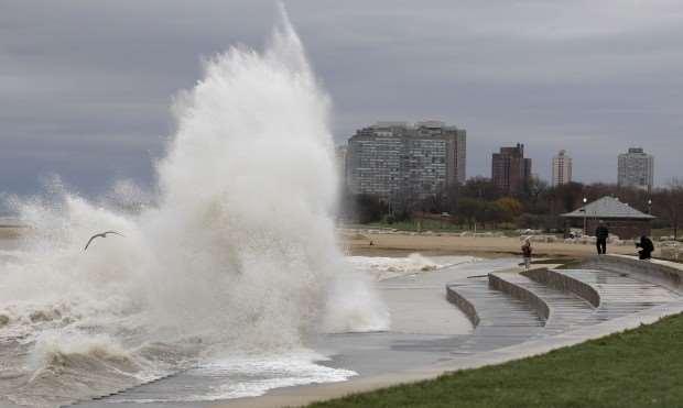
8 Overtopping Green, M. Spencer. AP Photo September 4,

9 Overtopping Jackson, Brian. North Ave. Beach September 4,

10 Overland Wave Propagation Unknown. Flooding in Green Bay, WI September 4,
11 11 Early attempts to identify flood risks
12 Waves and Erosion Waves Leverage USACE Wave Information Study (WIS) Local wave height with recurrence interval of 3 years approximately describes wave action likely to accompany the base flood ½ year was used on Lake Ontario due to a different fit for the wave data on the lake Erosion Based on FEMA (1989) Erosion (in square feet) = 85.6 * Recurrence Interval (in years) 270 square feet for 3-year recurrence 190 square feet for 2-year recurrence 12
13 2009 Update 1. Return period lake level recommended on a USACE (1988) report, but additional 20-years of observations 2. Wave runup is dominant risk and a response based approach is desirable 3. Previous wave guidance included long-term lake processes 13

14 14 Updated Water Levels

15 15 Combination of Water Levels and Waves
16 Great Lakes Coastal Flood Study Kicked off in 2009 Basin-wide assessment of flood risks Updated Guidance 16
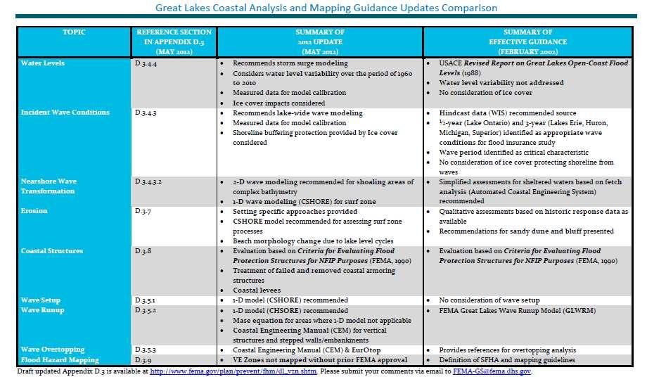
17 Crosswalk
18 December 1990 Storm
19
20 Overall Process Offshore Waves Still Water Level Levels Shoaling Zone Wave Transformation If Necessary Surf Zone Erosion Coastal Structures Wave Height Wave Crest Elevation Wave Setup Wave Runup Wave Overtopping Backshore Zone Flood Hazard Mapping

21 Study Approach Regional Study Approach Water level and wave analysis Improvement over communitycounty Reduces number of boundary conditions Greater consistency in assumptions Local/County Level Activities Mapping level tasks performed at county level Nearshore wave transformations Wave runup Overland wave propagation
22 Response Based Analysis Attempt to consider all (or most) of the complexity of the contributing processes controlling flooding and derive flood statistics from the results Contributing processes to be considered: Water level Wave conditions Topography

23 Topography & Bathymetry
24 Updates to Guidance Overview and Guidance on Selection and Application of Methods (Instructions for Toolbox) Detailed Guidance on Analyzing Coastal Processes (Toolbox) Guidance on Use of Results in Hazard Mapping, Documentation, and Reference Information Guidelines Overview and Important Contributors to Coastal Flooding D.3.1 Methodology for Storm Sampling and Coastal Flood Frequency Analysis D.3.2 Methodology for Analyzing Coastal Processes D.3.3 Waves and Water Levels D.3.4 Wave Setup, Runup and Overtopping D.3.5 Overland Wave Propagation D.3.6 Coastal Erosion D.3.7 Mapping of Hazard Zones and BFEs D.3.9 Study Documentation D.3.10 Coastal Structures D.3.8 References, Notation, and Acronyms D.3.11 D.3.13

25 Wave Setup Description of Wave Setup: localized impacts of water level at the shoreline during severe storms due to transfer of momentum from waves to the water column.
26 Wave Setup Implications for Flood Hazard Mapping Can be a significant contributor to the water level through its contribution to storm surge and should be included in the determination of coastal BFEs. 1-D Surf Zone Model Adequately resolve and represent inner surf zone Parametric representation Direct Integration Method _ H ' m ' H L
27 Wave Runup Limit of Wave Runup Storm Still Water Level Barrier Slope Breaker Depth Source: FEMA, 2003 Figure D Wave Runup Sketch
28 Wave Runup Approach Extract water level and wave pairings from the composite storm set Apply a method to estimate wave runup for each of the composite storm set pairings Conduct a statistical extreme value analysis on the runup elevations to determine 1-percent-annual-chance

29 Wave Overtopping Overtopping Rate Considerations for Establishing Flood Insurance Rate Zones Ponding Considerations


30 Onshore Wave Analysis Wave Runup Overland Wave Propagation

31 Overland Wave Propagation How waves interact with landforms Elevation Obstructions WHAFIS 1977 NAS report Version 4.0
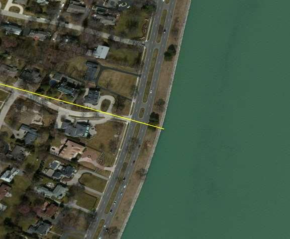
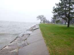
32 Transect
 Water level")
33 Hybrid Analysis WHAFIS is designed for event based analysis 1-percent-annual-chance water level 1-precent-annual-chance wave height Hybrid Joint probability approach (Nadal-Carabello et al, 2012) Water level Wave height Wave period
34 Five Scenarios Iso-probability curve Maximum water level, associated wave height Maximum wave height, associated water level Intermediate values Computed 1-percent-annual-chance water level Computed 1-percent-annual-chance wave height

35 Coastal Erosion Episodic, flood-related erosion due to coastal storm events Does not consider long-term erosion hazard areas Evaluated prior to wave runup and overland wave propagation


36 Erosion Assessment Methods 1-D surf zone dynamics model Requirements Cross-shore profile Sediment grain size


37 Coastal Structures Evaluation Criteria Detailed engineering evaluation (FEMA, 1990) Limited data and engineering judgment (USACE, 1989)
38 Vertical Structures
39 Sloped Structures
40 Updates to Guidance Overview and Guidance on Selection and Application of Methods (Instructions for Toolbox) Detailed Guidance on Analyzing Coastal Processes (Toolbox) Guidance on Use of Results in Hazard Mapping, Documentation, and Reference Information Guidelines Overview and Important Contributors to Coastal Flooding D.3.1 Methodology for Storm Sampling and Coastal Flood Frequency Analysis D.3.2 Methodology for Analyzing Coastal Processes D.3.3 Waves and Water Levels D.3.4 Wave Setup, Runup and Overtopping D.3.5 Overland Wave Propagation D.3.6 Coastal Erosion D.3.7 Coastal Structures D.3.8 Mapping of Hazard Zones and BFEs D.3.9 Study Documentation D.3.10 References, Notation, and Acronyms D.3.11 D.3.13

41 Mapping a Coastal Floodplain

42 Mapping Example - Ortho

43 Mapping Example - Terrain
44 Mapping Example - Mapping Decisions Transect 11 1% Total Water Level feet Top of coastal feature feet Base Flood Elevation 587 feet Profile 1% Total Water Level/BFE Transect 12 1% Total Water Level feet Top of coastal feature feet Base Flood Elevation 592 feet Profile 1% Total Water Level/BFE
45 Mapping Example - Gutters
46 Brian Caufield, P.E., CFM 46
2016 NC Coastal Local Governments Annual Meeting
 2016 NC Coastal Local Governments Annual Meeting Coastal Flood Study Modeling and Mapping 101 April 21, 2016 Tom Langan, PE, CFM Engineering Supervisor NCEM Floodplain Mapping Program FEMA Coastal Flood
Bay County, MI Coastal Hazard Analysis Flood Risk Review Meeting. May 14, 2018
 Bay County, MI Coastal Hazard Analysis Flood Risk Review Meeting May 14, 2018 Agenda Introductions Coastal Flood Risk Study and Mapping Program Current Status Technical Overview of Study and Mapping Floodplain
Door County, WI Coastal Hazard Analysis Flood Risk Review Meeting. August 21, 2017
 Door County, WI Coastal Hazard Analysis Flood Risk Review Meeting August 21, 2017 Agenda Introductions Coastal Flood Risk Study and Mapping Program Current Status Technical Overview of Study and Mapping
Baraga County, MI Coastal Hazard Analysis Flood Risk Review Meeting. July 12, 2018
 Baraga County, MI Coastal Hazard Analysis Flood Risk Review Meeting July 12, 2018 Agenda Introductions Coastal Flood Risk Study and Mapping Program Current Status Technical Overview of Study and Mapping
Evaluation of June 9, 2014 Federal Emergency Management Agency Flood Insurance Study for Town of Weymouth, Norfolk, Co, MA
 Evaluation of June 9, 2014 Federal Emergency Management Agency Flood Insurance Study for Town of Weymouth, Norfolk, Co, MA Prepared For: Woodard & Curran 95 Cedar Street, Suite 100 Providence, RI 02903
2017 Preliminary FEMA Flood Maps Old Orchard Beach Town Council Meeting. Old Orchard Beach, Town Hall July 18, 2017
 2017 Preliminary FEMA Flood Maps Old Orchard Beach Town Council Meeting Old Orchard Beach, Town Hall July 18, 2017 Overview Potential impacts of inaccurate Flood Insurance Rate Maps (FIRM) Why is appealing
Bayfield & Ashland Counties, WI Coastal Hazard Analysis Flood Risk Review Meeting. June 05, 2018
 Bayfield & Ashland Counties, WI Coastal Hazard Analysis Flood Risk Review Meeting June 05, 2018 Agenda Introductions Coastal Flood Risk Study and Mapping Program Current Status Technical Overview of Study
St. Louis County, MN Coastal Hazard Analysis Flood Risk Review Meeting. May 2, 2018
 St. Louis County, MN Coastal Hazard Analysis Flood Risk Review Meeting May 2, 2018 Agenda Introductions Coastal Flood Risk Study and Mapping Program Current Status Technical Overview of Study and Mapping
FEMA Region V. Great Lakes Coastal Flood Study. Pilot Study Webinar. Berrien County, Michigan. February 26, 2014
 FEMA Region V Great Lakes Coastal Flood Study Pilot Study Webinar Berrien County, Michigan February 26, 2014 2 Pilot Study Webinar Agenda Great Lakes Coastal Flood Study Background Demonstration Project
Sussex County, DE Preliminary Study Overview
 Sussex County, DE Preliminary Study Overview Coastal study scope: 102 miles of entire County shoreline Revised 102 panels for coastal study Riverine study scope: 14 streams, 67.1 miles, within the Nanticoke
Photo by: Darryl Hatheway, 2011
 Photo by: Darryl Hatheway, 2011 September 11, 2015 Presentation Discussion Examine PFD V-Zone Mapping in Wave Runup Dominated West Coast Application of PFD V-Zone Mapping Criteria in Pacific G&S PFD V-Zone
Technical Brief - Wave Uprush Analysis 129 South Street, Gananoque
 Technical Brief - Wave Uprush Analysis 129 South Street, Gananoque RIGGS ENGINEERING LTD. 1240 Commissioners Road West Suite 205 London, Ontario N6K 1C7 June 12, 2013 Table of Contents Section Page Table
City of Del Mar Local Coastal Plan (LCP) Amendment for Sea Level Rise and Coastal Flooding
 Amendment for Sea Level Rise and Coastal Flooding") City of Del Mar Local Coastal Plan (LCP) Amendment for Sea Level Rise and Coastal Flooding 6/22/17 Presentation to Sea Level Rise Stakeholder- Technical Advisory Committee (STAC) Nick Garrity, P.E. Lindsey
City of Del Mar Local Coastal Plan (LCP) Amendment for Sea Level Rise and Coastal Flooding 6/22/17 Presentation to Sea Level Rise Stakeholder- Technical Advisory Committee (STAC) Nick Garrity, P.E. Lindsey
Physical Map Revisions in Connecticut due to Updated Coastal Flood Hazards F8: Maps in Transition
 Physical Map Revisions in Connecticut due to Updated Coastal Flood Hazards F8: Maps in Transition Brian Caufield, P.E., CFM Principal Engineer CDM Smith Kerry Bogdan, CFM Senior Engineer FEMA Region I
Open Pacific Coast Study. California Coastal Analysis and Mapping Project
 Open Pacific Coast Study California Coastal Analysis and Mapping Project September 2012 California Open Coast Counties California Coastal Analysis and Mapping Project This publication is an initiative
Technical Brief - Wave Uprush Analysis Island Harbour Club, Gananoque, Ontario
 Technical Brief - Wave Uprush Analysis RIGGS ENGINEERING LTD. 1240 Commissioners Road West Suite 205 London, Ontario N6K 1C7 October 31, 2014 Table of Contents Section Page Table of Contents... i List
HURRICANE SANDY LIMITED REEVALUATION REPORT UNION BEACH, NEW JERSEY DRAFT ENGINEERING APPENDIX SUB APPENDIX D SBEACH MODELING
 HURRICANE SANDY LIMITED REEVALUATION REPORT UNION BEACH, NEW JERSEY DRAFT ENGINEERING APPENDIX SUB APPENDIX D SBEACH MODELING Rev. 18 Feb 2015 1 SBEACH Modeling 1.0 Introduction Following the methodology
Bob Battalio, PE Chief Engineer, ESA September 8, 2016
 RELATING FUTURE COASTAL CONDITIONS TO EXISTING FEMA FLOOD HAZARD MAPS Technical Methods Manual Bob Battalio, PE Chief Engineer, ESA September 8, 2016 FMA 2016 Sacramento, California DWR-OST-SIO PILOTING
Ventura County. Open Pacific Coast Study. California Coastal Analysis and Mapping Project
 Ventura County Open Pacific Coast Study California Coastal Analysis and Mapping Project December 2011 Project Name: Meeting: Date and Time: Location: California Coastal Analysis and Mapping Project (CCAMP)/Open
Citrus, Hernando, and Pasco Coastal Hazard Analysis. Flood Risk Review Meeting Citrus, Hernando, and Pasco Counties, Florida December 14, 2017
 Citrus, Hernando, and Pasco Coastal Hazard Analysis Flood Risk Review Meeting Citrus, Hernando, and Pasco Counties, Florida December 14, 2017 Introductions Risk MAP Project Team FEMA Region IV RAMPP (study
Beach Profiles. Topics. Module 9b Beach Profiles and Crossshore Sediment Transport 3/23/2016. CE A676 Coastal Engineering
 Beach Profiles AND CROSS-SHORE TRANSPORT Orson P. Smith, PE, Ph.D., Professor Emeritus Topics Features of beach and nearshore profiles Equilibrium profiles Cross-shore transport References Text (Sorensen)
FEMA West Coast Sea Level Rise Pilot Study
 FEMA West Coast Sea Level Rise Pilot Study Ed Curtis, P.E., CFM FEMA Region IX June 4, 2014 Presentation Objectives Present the goals of the FEMA West Coast Sea Level Rise Pilot Study Review the SLR Pilot
Future Condi,ons coastal hazard modeling and mapping
 Future Condi,ons coastal hazard modeling and mapping Presented by Bob Ba:alio, PE Environmental Science Associates, Inc. (ESA) On behalf of the physical processes team (USGS, TerraCosta- Scripps, ESA)
Figure 1 GE image of the Costa Sur & EcoEléctrica power plants, located inside Guayanilla and Tallaboa bay.
 1 7 - STORM SURGES IN PUERTO RICO_Power Plants-Costa Sur & EcoElectrica Costa Sur & EcoEléctrica Figure 1 shows a GE image of the Costa Sur (Guayanilla) and EcoElectrica site. Figure 2 shows the topographic
UPPER BEACH REPLENISHMENT PROJECT RELATED
 ASSESSMENT OF SAND VOLUME LOSS at the TOWNSHIP of UPPER BEACH REPLENISHMENT PROJECT RELATED to the LANDFALL OF HURRICANE SANDY - PURSUANT TO NJ-DR 4086 This assessment is in response to Hurricane Sandy
Pathways Interns: Annika O Dea, Ian Conery, Andrea Albright
 1 REMOTE SENSING OF COASTAL MORPHODYNAMICS 237 237 237 217 217 217 2 2 2 8 119 27 252 174.59 255 255 255 163 163 163 131 132 122 239 65 53 11 135 12 112 92 56 62 12 13 12 56 48 13 12 111 Kate Brodie Brittany
COASTAL MORPHODYNAMICS
 COASTAL MORPHODYNAMICS PATRICIA CHARDÓN-MALDONADO, PHD, EIT Miguel Canals, Jack A. Puleo, Alec Torres-Freyermuth & Jens Figlus March 9, 2017 OUTLINE INTRODUCTION Meteorological Phenomena Forcing Conditions
Appendix M: Durras Lake Tailwater Conditions
 Appendix M: Durras Lake Tailwater Conditions M.1 Preamble WRL has completed a tailwater condition assessment for the entrance to Durras Lake, to be used as an ocean boundary condition for a future flood
INTRODUCTION TO COASTAL ENGINEERING AND MANAGEMENT
 Advanced Series on Ocean Engineering Volume 16 INTRODUCTION TO COASTAL ENGINEERING AND MANAGEMENT J. William Kamphuis Queen's University, Canada World Scientific Singapore New Jersey London Hong Kong Contents
San Luis Obispo County December 2, 2014
 Flood Risk Review Meeting: Open Pacific Coast Study San Luis Obispo County December 2, 2014 Welcome and Introductions Flood Risk Review Meeting San Luis Obispo County California Coastal Analysis and Mapping
Limited Data, Complex Coastline and Successful Wave Modeling Challenges, Solutions and Lessons Learned
 Limited Data, Complex Coastline and Successful Wave Challenges, Solutions and Lessons Learned Paula Kulis, PhD Nader Mahmoudpour, PhD Lauren Klonsky June 11, 2013 Purpose Objectives Wave Procedure Challenges
MODELING OF CLIMATE CHANGE IMPACTS ON COASTAL STRUCTURES - CONTRIBUTION TO THEIR RE-DESIGN
 Proceedings of the 14 th International Conference on Environmental Science and Technology Rhodes, Greece, 3-5 September 2015 MODELING OF CLIMATE CHANGE IMPACTS ON COASTAL STRUCTURES - CONTRIBUTION TO THEIR
Monterey County December 3, 2014
 Flood Risk Review Meeting: Open Pacific Coast Study Monterey County December 3, 2014 Welcome and Introductions Flood Risk Review Meeting Monterey County California Coastal Analysis and Mapping Project
Shorelines Earth - Chapter 20 Stan Hatfield Southwestern Illinois College
 Shorelines Earth - Chapter 20 Stan Hatfield Southwestern Illinois College The Shoreline A Dynamic Interface The shoreline is a dynamic interface (common boundary) among air, land, and the ocean. The shoreline
COASTAL ENVIRONMENTS. 454 lecture 12
 COASTAL ENVIRONMENTS Repeated movement of sediment & water constructs a beach profile reflecting the balance between average daily or seasonal wave forces and resistance of landmass to wave action Coasts
BILLY BISHOP TORONTO CITY AIRPORT PRELIMINARY RUNWAY DESIGN COASTAL ENGINEERING STUDY
 Bâtiment Infrastructures municipales Transport Industriel Énergie Environnement BILLY BISHOP TORONTO CITY AIRPORT PRELIMINARY RUNWAY DESIGN COASTAL ENGINEERING STUDY N. Guillemette 1, C. Glodowski 1, P.
OECS Regional Engineering Workshop September 29 October 3, 2014
 B E A C H E S. M A R I N A S. D E S I G N. C O N S T R U C T I O N. OECS Regional Engineering Workshop September 29 October 3, 2014 Coastal Erosion and Sea Defense: Introduction to Coastal Dynamics David
Coastal and Hydraulics Laboratory
 Coastal and Hydraulics Laboratory ERDC/CHL TR-12-X Lake Michigan: Prediction of Sand Beach and Dune Erosion for Flood Hazard Assessment Bradley D. Johnson DRAFT April 2012 Great Lakes Coastal Flood Study,
CROSS-SHORE SEDIMENT PROCESSES
 The University of the West Indies Organization of American States PROFESSIONAL DEVELOPMENT PROGRAMME: COASTAL INFRASTRUCTURE DESIGN, CONSTRUCTION AND MAINTENANCE A COURSE IN COASTAL DEFENSE SYSTEMS I CHAPTER
CALCASIEU SALINITY STRUCTURES. HYDRODYNAMIC MODELING (To Support Design of Salinity Barriers)
") CALCASIEU SALINITY STRUCTURES HYDRODYNAMIC MODELING (To Support Design of Salinity Barriers) Presentation Overview 1 2 3 4 5 Project Overview and CEA Circulation Modeling Vessel Hydrodynamics Modeling
CALCASIEU SALINITY STRUCTURES HYDRODYNAMIC MODELING (To Support Design of Salinity Barriers) Presentation Overview 1 2 3 4 5 Project Overview and CEA Circulation Modeling Vessel Hydrodynamics Modeling
A Coastal Storm Modeling System for determination of flood hazards along a high energy coast in response to SLR and 21 st century storms
 Li Erikson, Patrick Barnard, Andrea O Neill, Jodi Eshleman, Amy Foxgrover, Michael Fitzgibbon 2, Grant Ballard 2, Kelly Higgason 3 A Coastal Storm Modeling System for determination of flood hazards along
G. Meadows, H. Purcell and L. Meadows University of Michigan
 www.coj.net/departments/fire+and+rescue/emergency+preparedness/rip+current.htm G. Meadows, H. Purcell and L. Meadows Over 80% of all surf related rescues are attributable to Rip Currents According to the
RI Regulatory Setbacks & Buffers: Coastal Management Issues
 RI Regulatory Setbacks & Buffers: Coastal Management Issues New England Onsite Wastewater Training Program @ URI OWT 155 - November 29, 2012 James Boyd - Coastal Policy Analyst Photo: October 30, 2012
DUXBURY WAVE MODELING STUDY
 DUXBURY WAVE MODELING STUDY 2008 Status Report Duncan M. FitzGerald Peter S. Rosen Boston University Northeaster University Boston, MA 02215 Boston, MA 02115 Submitted to: DUXBURY BEACH RESERVATION November
Red River Basin and FM Diversion Hydrology. North Dakota Water Education Foundation Executive Briefing July 13, 2012
 Red River Basin and FM Diversion Hydrology North Dakota Water Education Foundation Executive Briefing July 13, 2012 Red River Basin Total Drainage Area: 45,000 square miles North Dakota Fargo, ND Moorhead,
Oceans and Coasts. Chapter 18
 Oceans and Coasts Chapter 18 Exploring the oceans The ocean floor Sediments thicken and the age of the seafloor increases from ridge to shore The continental shelf off the northeast United States Constituent
/50. Physical Geology Shorelines
 Physical Geology Shorelines Multiple Guess: (You know the drill 2 points each) 1. The path of movement of a water particle in a wave at sea is 1. circular 2. horizontal 3. vertical 4. elliptical 5. none
Physical Modeling of Nearshore Placed Dredged Material Rusty Permenter, Ernie Smith, Michael C. Mohr, Shanon Chader
 Physical Modeling of Nearshore Placed Dredged Material Rusty Permenter, Ernie Smith, Michael C. Mohr, Shanon Chader Research Hydraulic Engineer ERDC-Coastal Hydraulics Laboratory October 25,2012 Study
New Jersey Coastal Zone Overview. The New Jersey Beach Profile Network (NJBPN) 3 Dimensional Assessments. Quantifying Shoreline Migration
 3 Dimensional Assessments. Quantifying Shoreline Migration") New Jersey Coastal Zone Overview The New Jersey Beach Profile Network (NJBPN) Objectives Profile Locations Data Collection Analyzing NJBPN Data Examples 3 Dimensional Assessments Methodology Examples Quantifying
New Jersey Coastal Zone Overview The New Jersey Beach Profile Network (NJBPN) Objectives Profile Locations Data Collection Analyzing NJBPN Data Examples 3 Dimensional Assessments Methodology Examples Quantifying
SUPPLEMENTAL DOCUMENT SEA LEVEL RISE SCENARIO SELECTION AND DESIGN TIDE CALCULATION
 SUPPLEMENTAL DOCUMENT SEA LEVEL RISE SCENARIO SELECTION AND DESIGN TIDE CALCULATION FOR THE GUIDANCE FOR INCORPORATING SEA LEVEL RISE INTO CAPITAL PLANNING IN SAN FRANCISCO: ASSESSING VULNERABILITY AND
Coastal Hazards Study
 Coastal Hazards Study 2212 Beach Boulevard, Pacifica Prepared for: EXECUTIVE SUMMARY City of Pacifica 170 Santa Maria Ave Pacifica, CA 94044 Prepared by: moffatt & nichol 2185 N. California Blvd. Walnut
Sea Level Rise and Coastal Flooding Why Waves Matter!
 Sea Level Rise and Coastal Flooding Why Waves Matter! Jason D. Burtner Massachusetts Office of Coastal Zone Management South Shore Regional Coordinator Sea Level Rise and Coastal Storm Damage and Flooding
Chapter 8 Wave climate and energy dissipation near Santa Cruz Island, California
 Chapter 8 Wave climate and energy dissipation near Santa Cruz Island, California NATHAN BURLEY A* AND ROBYN SUDDETH B A CIVIL & ENVIRONMENTAL ENGINEERING B GRADUATE GROUP IN HYDROLOGIC SCIENCES UNIVERSITY
We Make a Difference. New Maps, Now What? Updated Coastal Flood Hazard Information for Southern Georgia
 New Maps, Now What? Updated Coastal Flood Hazard Information for Southern Georgia New Maps, Now What? Risk MAP Project Team FEMA Region IV BakerAECOM, FEMA Mapping Partner GA DNR (CTP) NEFL Duval Flagler
GONE! Coastal Erosion Happens During Storms! Why Worry About Coastal Setbacks? Goals for Today
 RI Regulatory Setbacks & Buffers: Coastal Zone Management Issues New England Onsite Wastewater Training Program @ URI OWT 155 November 21, 2013 Goals for Today Understand the impacts of storms, coastal
STABLE DYNAMIC BEACH MODELLING FRAMEWORK
 GEOMORPHIC SOLUTIONS 141 Brunel Road Mississauga, ON L4Z 1X3 T 416 213 7121 F 95 89 8499 www.geomorphicsolutions.ca STABLE DYNAMIC BEACH MODELLING FRAMEWORK Geomorphic & Environmental Sciences Hazard Land
Boothbay Harbor Rotary Club May 12, 2016
 Mapping Potential Sea Level Rise and Storm Surge in Boothbay Harbor, ME Boothbay Harbor Rotary Club May 12, 2016 Peter A. Slovinsky, Marine Geologist Maine Geological Survey S.M. Dickson, MGS Quickly,
Kauai Wave Climate. Jessica Podoski, PE USACE Honolulu District
 Kauai Wave Climate Jessica Podoski, PE USACE Honolulu District Kauai Wave Climate Overview Study Regions WIS Hindcast Data & Analysis Wave Transformation NearshoreWave Climate Kauai Study Regions KekahaWave
Longshore sediment transport
 and Orson P. Smith, PE, Ph.D., Professor Emeritus Longshore transport Waves breaking at an angle to shore Sediment under breakers lifted by saltation Drops back to sea bed a little down drift Swash (runup)
A Preliminary Review of Beach Profile and Hardbottom Interactions
 A Preliminary Review of Beach Profile and Hardbottom Interactions Douglas W. Mann, P.E., D.CE. CB&I A World of Solutions Presentation Goal Lead to a better understanding of the challenges regarding the
REVETMENTS. Purposes and Operational Constraints. Purposes Erosion control o o. Revetment Design 4/5/2016. CE A676 Coastal Engineering
 REVETMENTS Ijsseldam, the Netherlands Orson P. Smith, PE, Ph.D. Instructor Purposes and Operational Constraints Purposes Erosion control o o Embankment Toe protection for a seawall, retaining wall or other
Update: UNSW s Research Program for Extreme Waves on Fringing Reefs. Matt Blacka,Kristen Splinter, Ron Cox
 Update: UNSW s Research Program for Extreme Waves on Fringing Reefs Matt Blacka,Kristen Splinter, Ron Cox Overview Research Area 1: Extreme wave and water level processes for fringing reef coastlines Research
Undertow - Zonation of Flow in Broken Wave Bores
 Nearshore Circulation Undertow and Rip Cells Undertow - Zonation of Flow in Broken Wave Bores In the wave breaking process, the landward transfer of water, associated with bore and surface roller decay
2. Water levels and wave conditions. 2.1 Introduction
 18 2. Water levels and wave conditions 2.1 Introduction This Overtopping Manual has a focus on the aspects of wave run-up and wave overtopping only. It is not a design manual, giving the whole design process
Overview. Beach Features. Coastal Regions. Other Beach Profile Features. CHAPTER 10 The Coast: Beaches and Shoreline Processes.
 Overview CHAPTER 10 The Coast: Beaches and Shoreline Processes Coastal regions constantly change. The beach is a dominant coastal feature. Wave activity continually modifies the beach and coastal areas.
Wave Energy Research and Applications
 Wave Energy Research and Applications Shoreline and Shallows conference East Lansing, MI March 7, 2019 Photo: Dave Sanford Waves Background 1. Types of Waves 2. Good and Bad Waves 3. Restoration Impacts
Available online at ScienceDirect. Procedia Engineering 116 (2015 )
") Available online at www.sciencedirect.com ScienceDirect Procedia Engineering 116 (2015 ) 320 325 8th International Conference on Asian and Pacific Coasts (APAC 2015) Department of Ocean Engineering, IIT
Available online at www.sciencedirect.com ScienceDirect Procedia Engineering 116 (2015 ) 320 325 8th International Conference on Asian and Pacific Coasts (APAC 2015) Department of Ocean Engineering, IIT
Appendix D: SWAN Wave Modelling
 Appendix D: SWAN Wave Modelling D.1 Preamble The Eurobodalla Shire Council area is subject to extreme waves originating from offshore storms. When swell waves approach the coast, they are modified by the
Undertow - Zonation of Flow in Broken Wave Bores
 Lecture 22 Nearshore Circulation Undertow - Zonation of Flow in Broken Wave Bores In the wave breaking process, the landward transfer of water, associated with bore and surface roller decay within the
A PRACTICAL APPROACH TO MAPPING EXTREME WAVE INUNDATION: CONSEQUENCES OF SEA-LEVEL RISE AND COASTAL EROSION.
 A PRACTICAL APPROACH TO MAPPING EXTREME WAVE INUNDATION: CONSEQUENCES OF SEA-LEVEL RISE AND COASTAL EROSION. Sean Vitousek 1, Charles H. Fletcher 1, Matthew M. Barbee 1 1. Department of Geology and Geophysics,
OECS Regional Engineering Workshop September 29 October 3, 2014
 B E A C H E S. M A R I N A S. D E S I G N. C O N S T R U C T I O N. OECS Regional Engineering Workshop September 29 October 3, 2014 Coastal Erosion and Sea Defense: Introduction to Coastal/Marine Structures
Natural Bridges Field Trip Activity
 Natural Bridges Field Trip Activity This is due in class on MONDAY- March 1 - not in sections! Name TA: NOTE ON THE GRADING OF THIS ASSIGNMENT: Many of the questions below (especially in the tidepool part)
Louisiana s 2012 Coastal Master Plan BARRIER SHORELINE MORPHOLOGY MODEL
 Louisiana Coastal Protection & Restorat coastal.louisiana.gov Louisiana s 2012 Coastal Master Plan PREDICTIVE MODELING: committed to our coast BARRIER SHORELINE MORPHOLOGY MODEL Dallon Weathers, University
consulting engineers and scientists
 consulting engineers and scientists Coastal Processes Presented by: January 9, 2015 Varoujan Hagopian, P.E. F.ASCE Senior Consultant, Waterfront Engineer Living Shoreline Workshop Lets Remember Why We
Deep-water orbital waves
 What happens when waves approach shore? Deep-water orbital waves Fig. 9.16, p. 211 Wave motion is influenced by water depth and shape of the shoreline wave buildup zone surf zone beach Wave base deepwater
Chapter - Oceans and Coasts
 Chapter - Oceans and Coasts Discussion: What do oceans contribute to the environment of Earth? How do Earth s major systems relate to the oceans? Oceans and Coasts Oceans are important - Thermal regulation
MECHANISM AND COUNTERMEASURES OF WAVE OVERTOPPING FOR LONG-PERIOD SWELL IN COMPLEX BATHYMETRY. Hiroaki Kashima 1 and Katsuya Hirayama 1
 MECHANISM AND COUNTERMEASURES OF WAVE OVERTOPPING FOR LONG-PERIOD SWELL IN COMPLEX BATHYMETRY Hiroaki Kashima 1 and Katsuya Hirayama 1 Recently, coastal disasters due to long-period swells induced by heavy
VOLUME 2 OF 5 VOLUSIA COUNTY, FLORIDA AND INCORPORATED AREAS COMMUNITY NAME NUMBER COMMUNITY NAME NUMBER
 VOLUME 2 OF 5 VOLUSIA COUNTY, FLORIDA AND INCORPORATED AREAS COMMUNITY NAME NUMBER COMMUNITY NAME NUMBER DAYTONA BEACH, CITY OF 125099 NEW SMYRNA BEACH, CITY OF 125132 DAYTONA BEACH SHORES, CITY OF 125100
4/20/17. #30 - Coastlines - General Principles Coastlines - Overview
 Writing Assignment Due one week from today by 11:59 pm See main class web pages for detailed instructions Essays will be submitted in Illinois Compass (instructions later) Pick one: Earthquakes, tsunamis,
SACO RIVER AND CAMP ELLIS BEACH SACO, MAINE SECTION 111 SHORE DAMAGE MITIGATION PROJECT APPENDIX F ECONOMIC ASSESSMENT
 SACO RIVER AND CAMP ELLIS BEACH SACO, MAINE SECTION 111 SHORE DAMAGE MITIGATION PROJECT APPENDIX F ECONOMIC ASSESSMENT Department of the Army New England District, Corps of Engineers 696 Virginia Road
Lecture Outlines PowerPoint. Chapter 15 Earth Science, 12e Tarbuck/Lutgens
 Lecture Outlines PowerPoint Chapter 15 Earth Science, 12e Tarbuck/Lutgens 2009 Pearson Prentice Hall This work is protected by United States copyright laws and is provided solely for the use of instructors
Nearshore Waves and Erosion Model Quantifying the Coastal Protection Benefits Provided by Natural Habitats
 Nearshore Waves and Erosion Model Quantifying the Coastal Protection Benefits Provided by Natural Habitats SaveGuanaCayReef Marinehindsight.com Necessary to quantify protection services offered by natural
Figure 4, Photo mosaic taken on February 14 about an hour before sunset near low tide.
 The Impact on Great South Bay of the Breach at Old Inlet Charles N. Flagg and Roger Flood School of Marine and Atmospheric Sciences, Stony Brook University Since the last report was issued on January 31
Technical Methods Manual Prepared for October 2016 California Department of Water Resources and California Ocean Science Trust
 RELATING FUTURE COASTAL CONDITIONS TO EXISTING FEMA FLOOD HAZARD MAPS Technical Methods Manual Prepared for October 2016 California Department of Water Resources and California Ocean Science Trust RELATING
Reading Material. Inshore oceanography, Anikouchine and Sternberg The World Ocean, Prentice-Hall
 Reading Material Inshore oceanography, Anikouchine and Sternberg The World Ocean, Prentice-Hall BEACH PROCESSES AND COASTAL ENVIRONMENTS COASTAL FEATURES Cross section Map view Terminology for Coastal
Beach Nourishment Impact on Beach Safety and Surfing in the North Reach of Brevard County, Florida
 Beach Nourishment Impact on Beach Safety and Surfing in the North Reach of Brevard County, Florida Prepared by John Hearin, Ph.D. Coastal Engineering Vice Chairman Cocoa Beach Chapter Port Canaveral Patrick
Nearshore Placed Mound Physical Model Experiment
 Nearshore Placed Mound Physical Model Experiment PURPOSE: This technical note describes the migration and dispersion of a nearshore mound subjected to waves in a physical model. The summary includes recommendations
MAR 110 LECTURE #15 Wave Hazards
 1 MAR 110 LECTURE #15 Wave Hazards Rogue Wave Hazard Rogue waves are very large open ocean waves of sometimes can range in height from 60 ft (20m) to120 feet (40m) and thus a significant hazard to large
Chapter 10 Lecture Outline. The Restless Oceans
 Chapter 10 Lecture Outline The Restless Oceans Focus Question 10.1 How does the Coriolis effect influence ocean currents? The Ocean s Surface Circulation Ocean currents Masses of water that flow from one
Soft Designs for a Harsh Climate: Trends in Coastal Engineering
 Alaska Department of Transportation & Public Facilities Ruth Carter, PE, and Harvey Smith, PE Coastal Engineering Section 20 October 2014 Soft Designs for a Harsh Climate: Trends in Coastal Engineering
Nearshore Morphodynamics. Bars and Nearshore Bathymetry. Sediment packages parallel to shore, that store beach sediment
 Nearshore Morphodynamics http://coastal.er.usgs.gov/bier/images/chandeleur-xbeach-lg.jpg Bars and Nearshore Bathymetry Sediment packages parallel to shore, that store beach sediment Can be up to 50 km
LOCALLY CONCENTRATED SEVERE BEACH EROSION ON SEISHO COAST CAUSED BY TYPHOON T0709
 F-4 Fourth International Conference on Scour and Erosion 2008 LOCALLY CONCENTRATED SEVERE BEACH EROSION ON SEISHO COAST CAUSED BY TYPHOON T0709 Yoshimitsu TAJIMA 1 and Shinji SATO 2 1 Member of JSCE, Associate
Follets Island Nearshore Beach Nourishment Project
 Coast & Harbor Engineering A division of Hatch Mott MacDonald Follets Island Nearshore Beach Nourishment Project Arpit Agarwal, P.E. April 1, 2016 Project Site!"#$% &'(% &)*+% )#,'-+% Shoreline Erosion
Coastal Wave Energy Dissipation: Observations and Modeling
 Coastal Wave Energy Dissipation: Observations and Modeling Jeffrey L Hanson US Army Corps of Engineers Field Research Facility USACE Field Research Facility Kent K. Hathaway US Army Corps of Engineers
RE: Hurricane Matthew Beach Damage Assessment and Recommendations [CSE 2416]
![RE: Hurricane Matthew Beach Damage Assessment and Recommendations [CSE 2416]](/thumbs/83/87675702.jpg "RE: Hurricane Matthew Beach Damage Assessment and Recommendations [CSE 2416]") October 25, 2016 Iris Hill Town Administrator Town of Edisto Beach 2414 Murray St Edisto Beach SC 29438 RE: Hurricane Matthew Beach Damage Assessment and Recommendations [CSE 2416] Dear Iris, Hurricane
October 25, 2016 Iris Hill Town Administrator Town of Edisto Beach 2414 Murray St Edisto Beach SC 29438 RE: Hurricane Matthew Beach Damage Assessment and Recommendations [CSE 2416] Dear Iris, Hurricane
COMPARISON OF ROCK SEAWALL AND DUNE FOR STORM DAMAGE REDUCTION
 COMPARISON OF ROCK SEAWALL AND DUNE FOR STORM DAMAGE REDUCTION Hyun Dong Kim 1, Nobuhisa Kobayashi 2, and Xavier Chávez Cárdenas 3 Four test series consisting of 14 tests and 140 runs (each run lasted
Chapter 15 SEASONAL CHANGES IN BEACHES OP THE NORTH ATLANTIC COAST OF THE UNITED STATES
 Chapter 15 SEASONAL CHANGES IN BEACHES OP THE NORTH ATLANTIC COAST OF THE UNITED STATES By John M. Darling Hydraulic Engineer, Research Division U. S. Army Coastal Engineering Research Center Corps of
INTRODUCTION TO COASTAL ENGINEERING
 The University of the West Indies Organization of American States PROFESSIONAL DEVELOPMENT PROGRAMME: COASTAL INFRASTRUCTURE DESIGN, CONSTRUCTION AND MAINTENANCE A COURSE IN COASTAL DEFENSE SYSTEMS I CHAPTER
EVALUATION OF BEACH EROSION UP-DRIFT OF TIDAL INLETS IN SOUTHWEST AND CENTRAL FLORIDA, USA. Mohamed A. Dabees 1 and Brett D.
 EVALUATION OF BEACH EROSION UP-DRIFT OF TIDAL INLETS IN SOUTHWEST AND CENTRAL FLORIDA, USA Mohamed A. Dabees 1 and Brett D. Moore 1 The paper discusses the analysis of up-drift beach erosion near selected
Low-crested offshore breakwaters: a functional tool for beach management
 Environmental Problems in Coastal Regions VI 237 Low-crested offshore breakwaters: a functional tool for beach management K. Spyropoulos & E. Andrianis TRITON Consulting Engineers, Greece Abstract Beach