Wave Energy Research and Applications
|
|
|
- Ashlynn Dean
- 5 years ago
- Views:
Transcription


1 Wave Energy Research and Applications Shoreline and Shallows conference East Lansing, MI March 7, 2019 Photo: Dave Sanford


2 Waves Background 1. Types of Waves 2. Good and Bad Waves 3. Restoration Impacts Photo: Dave Sanford 2
3 Wave 3
4 4

5 5

6 6

7 Shoreline Protection Waves Matter 7
8 8
9 9

10 Wave Model Use for Coastal Planning 10


 105")
")


11 Active Marine Stations Buoy (+33) 105 Fixed (+15)
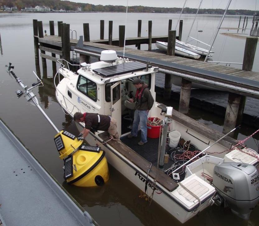

12 Data Collection Buoys
: 96 Ah (12v) + 75 W solar Power (right): 20 Ah")


13 Buoy Specifications Weight: 350lbs (left), 60lb (right) ballast Power (left): 96 Ah (12v) + 75 W solar Power (right): 20 Ah (12v) + 40 W Atmospheric Instruments Air Temp & R.H. Wind Speed & Direction Pressure Solar Radiation WEBCAM Water Instruments Wave height, period, direction Water temperature Water velocity Data Logger & Modem Campbell Scientific CR1000 SierraWireless RV50


14 Low Cost Environmental Sensing $500 to $1000 per unit to measure: Air, solar, water temp, water level, pressure 14
15 Coastal Research and Restoration Toolbox 1. Wave models: SWAN, SWASH 2. Hydrodynamic models: EFDC, FVCOM, MIKE2/MIKE3 3. Flooding models: FEPS, MIKE2, HEC-RAS2D 4. USACE Wave Information Studies (WIS) 5. Linking to regional/large-scale models 1. Climate models 2. Great Lakes Coastal Forecasting System 3. Storm surge modeling 15

16 Simulating WAves Nearshore (SWAN) 1. Third-generation wind wave model, developed at Delft University of Technology 2. Computes random, short-crested wind-generated waves in coastal regions and inland waters 3. Can operate on structured or unstructured grids 4. Simulated wave processes: 1. propagation in time and space, 2. shoaling, 3. refraction, 4. three- and four-wave interactions, 5. bottom friction 6. depth-induced breaking, 7. and dissipation 16
. 3.")
17 Simulating WAves till SHore (SWASH) 1. Companion model to SWAN that simulates wave run-up on shore. 2. Computes unsteady, non-hydrostatic, free-surface, rotational flow and transport phenomena in coastal waters as driven by waves, tides, buoyancy and wind forces (not a Boussinesq-type model). 3. Can operate on Cartesian or curvilinear grids 4. Simulated wave processes: 1. propagation in time and space, 2. shoaling, 3. refraction, 4. nonlinear wave-wave interactions, 5. wave breaking 6. wave runup and rundown 17
18 Environmental Fluid Dynamics Code (EFDC) 1. Surface water model that is capable of coupling hydrodynamic, water quality and sediment transport processes in a single simulation. 2. Can be applied in 1, 2, or 3-dimensions to simulate rivers, lakes, estuaries, coastal regions and wetlands. 3. EPA supported and approved 4. Widely used for pollutant source modeling. 5. Some limitations on spatial resolution due to curvilinear grid requirements 18

19 Finite Volume Community Ocean Model (FVCOM) 1. Three-dimensional fully coupled ice-ocean-wave-sedimentecosystem model 2. Originally developed to simulate hydrodynamics in coastal ocean regions; however it has recently gained popularity for use in large lakes 3. Operates on an unstructured grid 4. Coupled and linked with water quality, sediment transport, wave, and particle tracking sub-models 19
20 MIKE21 and MIKE3 models 1. Two- (MIKE21) and three- (MIKE3) dimensional fully coupled hydrodynamic models 2. Developed by DHI (Danish Hydraulic Institute) 3. Plug and Play additional modules to simulate different processes and constituents 1. Water quality 2. Waves 3. Sediment 4. Flooding, etc 4. Widely used globally for coastal modeling 20

21 Flood and Erosion Prediction System (FEPS) 1. Tool linking extensive datasets to GIS framework in order to estimate flooding potential and risk 2. Developed by Baird and Associates 3. Predicts rates of inundation and damage due to wave forces on structures 4. Quantifies flooding damages, erosion impacts, and shoreline protection maintenance costs over long time periods 21
22 Coastal Research and Restoration: Case Studies 1. Omans Creek, MI 2. Sugar Island, Detroit, MI 3. West Riverfront Park, Detroit, MI 4. Lake Ontario 5. Don River, Toronto, On 22


23 Little Girls Point and Omans Creek, MI Omans Creek is a small tributary to Lake Superior West shore of Omans Creek forms Little Girls Point, privately owned. Mouth of Omans Creek accumulates sediment and is regularly dredged to maintain boat access Michigan Department of Natural Resources owns land adjacent, including boat launch Objective: Study coastal processes causing sediment accumulation and propose design alternatives to protect creek mouth Tools: EFDC, SWAN 23

24 Little Girls Point and Omans Creek, MI Site conditions: Little Girl s Point shoreline classified as High Erosion Potential MDEQ estimates erosion rate of 1.7 to 1.8 feet per year. Median grain size 2 mm to 7 mm 24

25 Little Girls Point and Omans Creek, MI EFDC Hydrodynamic Model: Variable rectilinear grid ~120 m near mouth, to 2km in Lake Superior Up to 10 layers Simulation Current induced shear stress not sufficient to mobilize the medium sand (< 3 dynes/cm 2 ) 25
26 Little Girls Point and Omans Creek, MI SWAN Wind-Wave Model: Operates on same computational grid as EFDC model EFDC output is passes to SWAN model Dynamically simulates wave direction, height, period Dominant waves towards the southwest, breaking near project site. 26

27 Little Girls Point and Omans Creek, MI Combined Shear Stress effects: Currents alone not enough to mobilize material at site Waves and currents can be strong enough to mobilize larger material 27
28 Little Girls Point and Omans Creek, MI Design Alternative Considerations: Groyne to limit longshore sediment transport into creek mouth Some exposed bedrock Private property owners Adjacent waterbody (Ikwesens Creek). Design must not negatively impact nearby creek Environmental conditions Ice 28
29 Little Girls Point and Omans Creek, MI A) B) 29

30 Sugar Island, Detroit River, MI The island s habitat was suffering due to: Southern exposure to Lake Erie High water levels Wave and wind action Human disturbance from past land uses Human disturbance from the Livingstone Channel Cross Dike Objective: Explore ecological value and feasibility in controlling shoreline erosion and simultaneously enhancing fish and wildlife habitat Tools: FVCOM, SWAN 30
 Simulated transport conditions from 2017 Design alternatives were simulated, including")
31 Sugar Island, Detroit River, MI Hydrodynamic Modeling (FVCOM) FVCOM simulates hydrodynamic process including temperature effects, currents, and shear stress. Fine-scale, 3-dimensional unstructured model mesh (~10,000 horizontal computation elements, 2 vertical layers) Simulated transport conditions from 2017 Design alternatives were simulated, including placement of groynes on west shore of Sugar Island 31

32 Sugar Island, Detroit River, MI Baseline Conditions Simulated groyne 32

33 Sugar Island, Detroit River, MI Wind-wave modeling (SWAN) Used in steady-state model to simulate wave heights, periods, shear stress. Fine-scale, 2-dimensional unstructured model mesh covering all of the Western Basin of Lake Erie Simulated extreme conditions represented worst case scenario for waves to hit southern shore of Sugar Island 33
")
34 Sugar Island, Detroit River, MI Wind-wave Modeling (SWAN) 34

35 Sugar Island, Detroit River, MI Design Alternative Create barrier islands to protect southern shoreline. Islands also create beneficial habitat for fish, birds, and herptiles Models were run to simulate design morphology and assess impact on currents, waves, and bed stress 35


36 Sugar Island, Detroit River, MI 36

37 West Riverfront Park, Detroit River, MI Objectives: Revitalize Detroit s riverfront Provide destination and yearround activities for community members Improve fish and wildlife habitat near site. Tools: FVCOM (hydrodynamic and water quality), SWAN 37

38 West Riverfront Park, Detroit River, MI Project and Site Description Design must be protective of public health Project consists of monitoring, modeling, and development of operational strategies Modeling to assess physical transport as well as bacterial pollution potential ~30 untreated or partially treated sewer overflows 38

39 West Riverfront Park, Detroit River, MI FVCOM Hydrodynamic Model Very-fine scale 3-dimensional unstructured grid Simulate water velocities and shear stresses Design aquatic habitat areas based on flow characteristics - sheltering opportunities, velocity gradients, recirculating eddies Design of pipe to flush the cove ensure recirculation Sediment transport properties (areas of likely scour and deposition) Model bacteria concentrations in the Detroit River and Cove considering the pollutant sources 39
40 West Riverfront Park, Detroit River, MI 40

41 West Riverfront Park, Detroit River, MI 41

42 West Riverfront Park, Detroit River, MI Water quality model simulating bacteria sources and transport Still in development Wind wave modeling to be added 42


43 Coastal Shorelines, Lake Ontario Properties along shore of Lake Ontario experiencing significant flooding, erosion and financial damages as a result of higher and changing water levels. International Joint Commission regulates water levels Objectives: Assess costs associated with flooding and erosion damages Identify properties for nature-based (NBS) solutions Tools: FEPS 43

44 Coastal Shorelines, Lake Ontario Great diversity in shoreline Coastal geology, topography, and bathymetry Shoreline erodibility Building setbacks Financial wealth of property owners 44

45 Coastal Shorelines, Lake Ontario IJC Water Level Regulation Plans Range in Expected Average Annual Economic Impact By Use Million USD Coastal (FEPS) to -0.1 Commercial Nav to Hydropower to Rec. Boating to IJC, International Lake Ontario-St. Lawrence River Study Board. Options for Managing Lake Ontario and St. Lawrence River Water Levels and Flows: Final Report to the International Joint Commission. March
46 Coastal Shorelines, Lake Ontario Flood Erosion Prediction System (FEPS) model developed to evaluate the influence of lake level fluctuations on erosion processes and the associated economic damages Higher water level regimes result in accelerated shoreline erosion Low water levels also exacerbate damage through erosion of the toe of the bank Pairing of FEPS data to identify properties more conducive to nature-based (NBS) solutions 46

47 Don River, Toronto, Lake Ontario As part of the Don River mouth naturalization and Port Lands Flood Protection Project, flood and wave modeling were performed to assess the feasibility and impact of restoration alternatives. Objectives: achieve naturalization of the mouth of the Don River, and to provide flood protection to allow for the redevelopment of the surrounding lands Tools : MIKE21, SWAN 47

48 Don River, Toronto, Lake Ontario MIKE21/MIKE FLOOD Hydrodynamic Model 2-dimensional fine-scale unstructured grid Proposed design bathymetry simulated in model to ensure surrounding lands do not flood. 48

49 Don River, Toronto, Lake Ontario MIKE21/MIKE FLOOD Hydrodynamic Model Simulations helped inform naturalization and revitalization design decisions based on extent of flooding, velocities and shear stresses. 49

50 Don River, Toronto, Lake Ontario SWAN Wave Model Fine-scale rectilinear grid (1m x1m resolution) Simulated wind-driven waves originating from Toronto Harbor Simulated boat generated waves within the channel 50
51 Don River, Toronto, Lake Ontario SWAN Wave Model Wind-driven waves under 100 year storm event Wind direction directly into naturalized channel Waves dissipate fairly quickly within channel 51

52 Don River, Toronto, Lake Ontario SWAN Wave Model Boat generated waves Waves simulated perpendicular to shoreline Waves can reach up to 2m in height when accounting for reflection from opposite dock wall but dissipate before reaching inland shore 52
DUXBURY WAVE MODELING STUDY
 DUXBURY WAVE MODELING STUDY 2008 Status Report Duncan M. FitzGerald Peter S. Rosen Boston University Northeaster University Boston, MA 02215 Boston, MA 02115 Submitted to: DUXBURY BEACH RESERVATION November
IMPACTS OF COASTAL PROTECTION STRATEGIES ON THE COASTS OF CRETE: NUMERICAL EXPERIMENTS
 IMPACTS OF COASTAL PROTECTION STRATEGIES ON THE COASTS OF CRETE: NUMERICAL EXPERIMENTS Tsanis, I.K., Saied, U.M., Valavanis V. Department of Environmental Engineering, Technical University of Crete, Chania,
An Investigation of the Influence of Waves on Sediment Processes in Skagit Bay
 DISTRIBUTION STATEMENT A. Approved for public release; distribution is unlimited. An Investigation of the Influence of Waves on Sediment Processes in Skagit Bay Geoffrey W. Cowles School for Marine Science
MODELING OF CLIMATE CHANGE IMPACTS ON COASTAL STRUCTURES - CONTRIBUTION TO THEIR RE-DESIGN
 Proceedings of the 14 th International Conference on Environmental Science and Technology Rhodes, Greece, 3-5 September 2015 MODELING OF CLIMATE CHANGE IMPACTS ON COASTAL STRUCTURES - CONTRIBUTION TO THEIR
Unsteady Wave-Driven Circulation Cells Relevant to Rip Currents and Coastal Engineering
 Unsteady Wave-Driven Circulation Cells Relevant to Rip Currents and Coastal Engineering Andrew Kennedy Dept of Civil and Coastal Engineering 365 Weil Hall University of Florida Gainesville, FL 32611 phone:
CROSS-SHORE SEDIMENT PROCESSES
 The University of the West Indies Organization of American States PROFESSIONAL DEVELOPMENT PROGRAMME: COASTAL INFRASTRUCTURE DESIGN, CONSTRUCTION AND MAINTENANCE A COURSE IN COASTAL DEFENSE SYSTEMS I CHAPTER
Exploring Localized Mixing Dynamics During Wet Weather in a Tidal Fresh Water System
 Exploring Localized Mixing Dynamics During Wet Weather in a Tidal Fresh Water System Ramona McCullough & Phil Duzinski Delaware Estuary Science & Environmental Summit January 27, 2015 Background and objectives
SWASH MODELLING OF A COASTAL PROTECTION SCHEME
 SWASH MODELLING OF A COASTAL PROTECTION SCHEME Mark Klein 1, Andrew Symonds 2, Marcel Zijlema 3, Dan Messiter 4 and Michael Dufour 5 The Beresford shoreline, Australia, is subject to a complex interaction
Nearshore Sediment Transport What influences the loss of sediment on Beaches? - Waves - Winds - Tidal Currents - River discharge - Runoff
 Tides & Beaches Nearshore Sediment Transport What influences the loss of sediment on Beaches? - Waves - Winds - Tidal Currents - River discharge - Runoff Oceans Ocean Topography Physical Structure of the
Nearshore Dredged Material Placement Pilot Study at Noyo Harbor, CA
 1 Nearshore Dredged Material Placement Pilot Study at Noyo Harbor, CA Noyo Cove N 2011 National Conference on Beach Preservation Technology 9-11, February 2011 Lihwa Lin, Honghai Li, Mitchell Brown US
An Investigation of the Influence of Waves on Sediment Processes in Skagit Bay
 DISTRIBUTION STATEMENT A. Approved for public release; distribution is unlimited. An Investigation of the Influence of Waves on Sediment Processes in Skagit Bay Geoffrey W. Cowles School for Marine Science
PRINCIPLES OF FLUID FLOW AND SURFACE WAVES RIVERS, ESTUARIES, SEAS AND OCEANS. Leo C. van Rijn
 PRINCIPLES OF FLUID FLOW AND SURFACE WAVES IN RIVERS, ESTUARIES, SEAS AND OCEANS (Edition 2011) Leo C. van Rijn Physical Geography Other publications: Principles of Sediment Transport in Rivers, Estuaries
Evaluation of Placement Alternatives for Matagorda Ship Channel Bottleneck Removal
 Evaluation of Placement Alternatives for Matagorda Ship Channel Bottleneck Removal James Rosati III Ashley E. Frey CPT Grays Harbor, WA Wood Wood chips Flour Other CMS Shark River Inlet, NJ US Army Corps
Bay County, MI Coastal Hazard Analysis Flood Risk Review Meeting. May 14, 2018
 Bay County, MI Coastal Hazard Analysis Flood Risk Review Meeting May 14, 2018 Agenda Introductions Coastal Flood Risk Study and Mapping Program Current Status Technical Overview of Study and Mapping Floodplain
OECS Regional Engineering Workshop September 29 October 3, 2014
 B E A C H E S. M A R I N A S. D E S I G N. C O N S T R U C T I O N. OECS Regional Engineering Workshop September 29 October 3, 2014 Coastal Erosion and Sea Defense: Introduction to Coastal Dynamics David
INTRODUCTION TO COASTAL ENGINEERING
 The University of the West Indies Organization of American States PROFESSIONAL DEVELOPMENT PROGRAMME: COASTAL INFRASTRUCTURE DESIGN, CONSTRUCTION AND MAINTENANCE A COURSE IN COASTAL DEFENSE SYSTEMS I CHAPTER
Undertow - Zonation of Flow in Broken Wave Bores
 Nearshore Circulation Undertow and Rip Cells Undertow - Zonation of Flow in Broken Wave Bores In the wave breaking process, the landward transfer of water, associated with bore and surface roller decay
COASTAL ENVIRONMENTS. 454 lecture 12
 COASTAL ENVIRONMENTS Repeated movement of sediment & water constructs a beach profile reflecting the balance between average daily or seasonal wave forces and resistance of landmass to wave action Coasts
LOCALLY CONCENTRATED SEVERE BEACH EROSION ON SEISHO COAST CAUSED BY TYPHOON T0709
 F-4 Fourth International Conference on Scour and Erosion 2008 LOCALLY CONCENTRATED SEVERE BEACH EROSION ON SEISHO COAST CAUSED BY TYPHOON T0709 Yoshimitsu TAJIMA 1 and Shinji SATO 2 1 Member of JSCE, Associate
Physical Modeling of Nearshore Placed Dredged Material Rusty Permenter, Ernie Smith, Michael C. Mohr, Shanon Chader
 Physical Modeling of Nearshore Placed Dredged Material Rusty Permenter, Ernie Smith, Michael C. Mohr, Shanon Chader Research Hydraulic Engineer ERDC-Coastal Hydraulics Laboratory October 25,2012 Study
Waves. G. Cowles. General Physical Oceanography MAR 555. School for Marine Sciences and Technology Umass-Dartmouth
 Waves G. Cowles General Physical Oceanography MAR 555 School for Marine Sciences and Technology Umass-Dartmouth Waves Sound Waves Light Waves Surface Waves Radio Waves Tidal Waves Instrument Strings How
The History of Coastal Flood Hazard Assessments in the Great Lakes
 The History of Coastal Flood Hazard Assessments in the Great Lakes Brian A. Caufield, P.E., CFM June 23, 2016 2 The Great Lakes Some Statistics Courtesy of Great Lakes Information Network One-fifth of
Figure 4, Photo mosaic taken on February 14 about an hour before sunset near low tide.
 The Impact on Great South Bay of the Breach at Old Inlet Charles N. Flagg and Roger Flood School of Marine and Atmospheric Sciences, Stony Brook University Since the last report was issued on January 31
CHAPTER 134 INTRODUCTION
 CHAPTER 134 NEW JETTIES FOR TUNG-KANG FISHING HARBOR, TAIWAN Chi-Fu Su Manager Engineering Department Taiwan Fisheries Consultants, Inc. Taipei, Taiwan INTRODUCTION Tung-Kang Fishing Harbor, which is about
/50. Physical Geology Shorelines
 Physical Geology Shorelines Multiple Guess: (You know the drill 2 points each) 1. The path of movement of a water particle in a wave at sea is 1. circular 2. horizontal 3. vertical 4. elliptical 5. none
Wave energy converter effects on wave and sediment circulation
 Wave energy converter effects on wave and sediment circulation Grace Chang and Craig Jones Integral Consulting Inc. cjones@integral-corp.com; gchang@integral-corp.com Jesse Roberts, Kelley Ruehl, and Chris
Nearshore wave-flow modelling with SWASH
 Nearshore wave-flow modelling with SWASH th Waves Workshop Marcel, Guus and Pieter November, /37 Delft University of Technology Motivation Goal: to develop a model that is capable of simulating wave motion
MODELLING WAVE-TIDE INTERACTIONS AT A WAVE FARM IN THE SOUTHWEST OF ENGLAND
 MODELLING WAVE-TIDE INTERACTIONS AT A WAVE FARM IN THE SOUTHWEST OF ENGLAND Raúl González-Santamaría 1, Qingping Zou 1, Shunqi Pan 1, Roberto Padilla-Hernandez 2 The Wave Hub project will create the world
TITLE: North Carolina s Changing Shorelines. KEYWORDS: erosion - shorelines - mapping - sustainability
 UNC Coastal Studies Institute Teacher Resources 1 TITLE: North Carolina s Changing Shorelines KEYWORDS: erosion - shorelines - mapping - sustainability Changing shorelines impact coastal infrastructure.
Preliminary Wake Wash Impact Analysis Redwood City Ferry Terminal, Redwood City, CA
 Technical Memorandum Preliminary Wake Wash Impact Analysis Redwood City Ferry Terminal, Redwood City, CA 1. Introduction The following preliminary wake wash impact analysis was initiated by the Port of
P.P. Shirshov Institute of Oceanology, Russian Academy of Sciences. Moscow, RUSSIA.
 P.P. Shirshov Institute of Oceanology, Russian Academy of Sciences. Moscow, RUSSIA. E-mail: akivis@ocean.ru Introduction The nearshore zone, though occupying only a small part of seas and oceans, plays
BILLY BISHOP TORONTO CITY AIRPORT PRELIMINARY RUNWAY DESIGN COASTAL ENGINEERING STUDY
 Bâtiment Infrastructures municipales Transport Industriel Énergie Environnement BILLY BISHOP TORONTO CITY AIRPORT PRELIMINARY RUNWAY DESIGN COASTAL ENGINEERING STUDY N. Guillemette 1, C. Glodowski 1, P.
STUDY ON TSUNAMI PROPAGATION INTO RIVERS
 ABSTRACT STUDY ON TSUNAMI PROPAGATION INTO RIVERS Min Roh 1, Xuan Tinh Nguyen 2, Hitoshi Tanaka 3 When tsunami wave propagation from the narrow river mouth, water surface is raised and fluctuated by long
Undertow - Zonation of Flow in Broken Wave Bores
 Lecture 22 Nearshore Circulation Undertow - Zonation of Flow in Broken Wave Bores In the wave breaking process, the landward transfer of water, associated with bore and surface roller decay within the
Passage Key Inlet, Florida; CMS Modeling and Borrow Site Impact Analysis
 Passage Key Inlet, Florida; CMS Modeling and Borrow Site Impact Analysis by Kelly R. Legault and Sirisha Rayaprolu PURPOSE: This Coastal and Hydraulics Engineering Technical Note (CHETN) describes the
Hydrodynamic Modeling of Tides and Hurricane Storm Surge for Pre- and Post-Dredging Conditions in the Lower St. Johns River, Florida
 Hydrodynamic Modeling of Tides and Hurricane Storm Surge for Pre- and Post-Dredging Conditions in the Lower St. Johns River, Florida Matthew V. Bilskie 1 1 PhD Student, University of Central Florida, Department
EVALUATION OF BEACH EROSION UP-DRIFT OF TIDAL INLETS IN SOUTHWEST AND CENTRAL FLORIDA, USA. Mohamed A. Dabees 1 and Brett D.
 EVALUATION OF BEACH EROSION UP-DRIFT OF TIDAL INLETS IN SOUTHWEST AND CENTRAL FLORIDA, USA Mohamed A. Dabees 1 and Brett D. Moore 1 The paper discusses the analysis of up-drift beach erosion near selected
Available online at ScienceDirect. Procedia Engineering 116 (2015 )
") Available online at www.sciencedirect.com ScienceDirect Procedia Engineering 116 (2015 ) 320 325 8th International Conference on Asian and Pacific Coasts (APAC 2015) Department of Ocean Engineering, IIT
Available online at www.sciencedirect.com ScienceDirect Procedia Engineering 116 (2015 ) 320 325 8th International Conference on Asian and Pacific Coasts (APAC 2015) Department of Ocean Engineering, IIT
The construction of Deepwater Navigation Channel (DNC) in the Bystry arm of the Danube Delta has started in The whole project provides the
 in the Bystry arm of the Danube Delta has started in The whole project provides the") Annex 45 Numerical Studies of Waves, Currents and Sediment Transport at the Marine Part of Deepwater Navigation Channel through the Bystry Arm of the Danube Delta and Model Verification based on Laboratory
Annex 45 Numerical Studies of Waves, Currents and Sediment Transport at the Marine Part of Deepwater Navigation Channel through the Bystry Arm of the Danube Delta and Model Verification based on Laboratory
The impact of ocean bottom morphology on the modelling of long gravity waves from tides and tsunami to climate
 The impact of ocean bottom morphology on the modelling of long gravity waves from tides and tsunami to climate Christian Le Provost and Florent Lyard Laboratoire d Etudes en Géophysique et Océanographie
Water Resources Report RKLD Annual Meeting July 30, 2016
 Water Resources Report RKLD Annual Meeting 2016 July 30, 2016 Topics Hydrology Report Indianford Dam trash rack cleanout performance Experimental Project update Review of PAS project Twin floods- 1 to
Wave Transformation Modeling with Bottom Friction Applied to the Southeast Oahu Reefs. Mary A. Cialone and Jane McKee Smith
 Wave Transformation Modeling with Bottom Friction Applied to the Southeast Oahu Reefs Mary A. Cialone and Jane McKee Smith Outline Objective Study Area STWAVE Friction Formulations Model Validation Summary
Bayfield & Ashland Counties, WI Coastal Hazard Analysis Flood Risk Review Meeting. June 05, 2018
 Bayfield & Ashland Counties, WI Coastal Hazard Analysis Flood Risk Review Meeting June 05, 2018 Agenda Introductions Coastal Flood Risk Study and Mapping Program Current Status Technical Overview of Study
Training program on Modelling: A Case study Hydro-dynamic Model of Zanzibar channel
 Training program on Modelling: A Case study Hydro-dynamic Model of Zanzibar channel Mayorga-Adame,C.G., Sanga,I.P.L., Majuto, C., Makame, M.A., Garu,M. INTRODUCTION Hydrodynamic Modeling In understanding
Predicting wave conditions in a coral embayment from offshore directional spectral model input
 Predicting wave conditions in a coral embayment from offshore directional spectral model input Ron Hoeke 1,2 and Curt Storlazzi 3 1 Coral Reef Ecosystem Division (CRED) NOAA Pacific Islands Fisheries Science
Pathways Interns: Annika O Dea, Ian Conery, Andrea Albright
 1 REMOTE SENSING OF COASTAL MORPHODYNAMICS 237 237 237 217 217 217 2 2 2 8 119 27 252 174.59 255 255 255 163 163 163 131 132 122 239 65 53 11 135 12 112 92 56 62 12 13 12 56 48 13 12 111 Kate Brodie Brittany
HARBOUR SEDIMENTATION - COMPARISON WITH MODEL
 HARBOUR SEDIMENTATION - COMPARISON WITH MODEL ABSTRACT A mobile-bed model study of Pointe Sapin Harbour, in the Gulf of St. Lawrence, resulted in construction of a detached breakwater and sand trap to
Door County, WI Coastal Hazard Analysis Flood Risk Review Meeting. August 21, 2017
 Door County, WI Coastal Hazard Analysis Flood Risk Review Meeting August 21, 2017 Agenda Introductions Coastal Flood Risk Study and Mapping Program Current Status Technical Overview of Study and Mapping
Imagine that you can see a side view of a wave as it approaches a beach. Describe how the wave changes as the wave approaches the beach.
 Geology 101 Name Reading Guide for Ch. 19: Shores and Coastal Processes (p. 612) Waves, Currents, and Tides (p. 614) Waves and Currents (p. 614) Imagine that you can see a side view of a wave as it approaches
St. Louis County, MN Coastal Hazard Analysis Flood Risk Review Meeting. May 2, 2018
 St. Louis County, MN Coastal Hazard Analysis Flood Risk Review Meeting May 2, 2018 Agenda Introductions Coastal Flood Risk Study and Mapping Program Current Status Technical Overview of Study and Mapping
Low-crested offshore breakwaters: a functional tool for beach management
 Environmental Problems in Coastal Regions VI 237 Low-crested offshore breakwaters: a functional tool for beach management K. Spyropoulos & E. Andrianis TRITON Consulting Engineers, Greece Abstract Beach
Chapter 10 Lecture Outline. The Restless Oceans
 Chapter 10 Lecture Outline The Restless Oceans Focus Question 10.1 How does the Coriolis effect influence ocean currents? The Ocean s Surface Circulation Ocean currents Masses of water that flow from one
Coastal storm damage reduction program in Salerno Province after the winter 2008 storms
 Coastal Processes 119 Coastal storm damage reduction program in Salerno Province after the winter 2008 storms G. Benassai 1, P. Celentano 2 & F. Sessa 3 1 Department of Applied Sciences, University of
SELECTION OF THE PREFERRED MANAGEMENT OPTION FOR STOCKTON BEACH APPLICATION OF 2D COASTAL PROCESSES MODELLING
 SELECTION OF THE PREFERRED MANAGEMENT OPTION FOR STOCKTON BEACH APPLICATION OF 2D COASTAL PROCESSES MODELLING C Allery 1 1 DHI Water and Environment, Sydney, NSW Abstract This paper presents an approach
Appendix D: SWAN Wave Modelling
 Appendix D: SWAN Wave Modelling D.1 Preamble The Eurobodalla Shire Council area is subject to extreme waves originating from offshore storms. When swell waves approach the coast, they are modified by the
Deep-water orbital waves
 What happens when waves approach shore? Deep-water orbital waves Fig. 9.16, p. 211 Wave motion is influenced by water depth and shape of the shoreline wave buildup zone surf zone beach Wave base deepwater
Summary of Water Access for Marinas and Public Boat Ramps
 Lake Tahoe Shoreline Plan Meeting Materials: Steering Committee Last Updated: 11-28-16 Summary of Water Access for Marinas and Public Boat Ramps Table 1: Marinas Buoy Field Assessment Marinas 1. North
Coastal Change and Conflict
 Coastal Change and Conflict Outline of the Topic Contrasting Coasts why do all coasts not look the same? Geology of the coast the impact rock structure has on the coastline Waves Constructive and destructive
Paper Environmental friendly solutions to improve the navigation fairway of the Danube in Serbia
 Paper 166 - Environmental friendly solutions to improve the navigation fairway of the Danube in Serbia ZUIJDERWIJK Michel, MUSKATIROVIC Jasna, MITROVIC Ivan, TJERRY Soren, ZANETTI Roberto Witteveen+Bos,
Chapter - Oceans and Coasts
 Chapter - Oceans and Coasts Discussion: What do oceans contribute to the environment of Earth? How do Earth s major systems relate to the oceans? Oceans and Coasts Oceans are important - Thermal regulation
Baird. Innovation, Excellence & Service Oceans, Lakes & Rivers
 Profile Capabilities Innovation, Excellence & Service Oceans, Lakes & Rivers Baird provides professional engineering and technical services related to the design of coastal structures and facilities that
Technical Brief - Wave Uprush Analysis Island Harbour Club, Gananoque, Ontario
 Technical Brief - Wave Uprush Analysis RIGGS ENGINEERING LTD. 1240 Commissioners Road West Suite 205 London, Ontario N6K 1C7 October 31, 2014 Table of Contents Section Page Table of Contents... i List
4/20/17. #30 - Coastlines - General Principles Coastlines - Overview
 Writing Assignment Due one week from today by 11:59 pm See main class web pages for detailed instructions Essays will be submitted in Illinois Compass (instructions later) Pick one: Earthquakes, tsunamis,
G. Meadows, H. Purcell and L. Meadows University of Michigan
 www.coj.net/departments/fire+and+rescue/emergency+preparedness/rip+current.htm G. Meadows, H. Purcell and L. Meadows Over 80% of all surf related rescues are attributable to Rip Currents According to the
CMS Modeling of the North Coast of Puerto Rico
 CMS Modeling of the North Coast of Puerto Rico PRESENTED BY: Dr. Kelly Rankin Legault, Ph.D., P.E. 1 Dr. Alfredo Torruella, Ph.D. 2 1 USACE Jacksonville District 2 University of Puerto Rico October 2016
REVETMENTS. Purposes and Operational Constraints. Purposes Erosion control o o. Revetment Design 4/5/2016. CE A676 Coastal Engineering
 REVETMENTS Ijsseldam, the Netherlands Orson P. Smith, PE, Ph.D. Instructor Purposes and Operational Constraints Purposes Erosion control o o Embankment Toe protection for a seawall, retaining wall or other
Nearshore Placed Mound Physical Model Experiment
 Nearshore Placed Mound Physical Model Experiment PURPOSE: This technical note describes the migration and dispersion of a nearshore mound subjected to waves in a physical model. The summary includes recommendations
Surface Wave Dynamics in the Coastal Zone
 DISTRIBUTION STATEMENT A. Approved for public release; distribution is unlimited. Surface Wave Dynamics in the Coastal Zone Gerbrant Ph. van Vledder Department of Civil engineering and Geosciences, Delft
Coastal Environments Oceanographic and Engineering Expertise
 Coastal Environments Oceanographic and Engineering Expertise Coastal Environments La Jolla, CA www.coastalenvironments.com 14 May 2004 CE Ref. No. 04-05 EcoSystems Management Associates, Inc. Carlsbad,
Currents measurements in the coast of Montevideo, Uruguay
 Currents measurements in the coast of Montevideo, Uruguay M. Fossati, D. Bellón, E. Lorenzo & I. Piedra-Cueva Fluid Mechanics and Environmental Engineering Institute (IMFIA), School of Engineering, Research
GRAND RAPIDS RESTORATION GRAND RAPIDS REVITALIZATION
 GRAND RAPIDS RESTORATION RETURNING THE RAPIDS TO THE GRAND WHY IS THIS PLACE CALLED GRAND RAPIDS? We have been asking for over 100- years, where are the rapids? WHY IS THIS PLACE CALLED GRAND RAPIDS? compare
from a decade of CCD temperature data
 (Some of) What we have learned from a decade of CCD temperature data Craig Gelpi and Karen Norris Long Beach Aquarium of the Pacific August 15, 2008 Introduction Catalina Conservancy Divers collected temperature
Simulation of hydraulic regime and sediment transport in the Mekong delta coast
 Simulation of hydraulic regime and sediment transport in the Mekong delta coast 1. Introduction Coastal erosion in the Mekong Delta has been recorded in recent years and the erosion rate has been increasing
Shoreline Evolution Due to Oblique Waves in Presence of Submerged Breakwaters. Nima Zakeri (Corresponding Author), Mojtaba Tajziehchi
, Mojtaba Tajziehchi") Shoreline Evolution Due to Oblique Waves in Presence of Submerged Breakwaters Nima Zakeri (Corresponding Author), Mojtaba Tajziehchi Department of Civil Engineering, Faculty of Engineering, University
Shoreline Evolution Due to Oblique Waves in Presence of Submerged Breakwaters Nima Zakeri (Corresponding Author), Mojtaba Tajziehchi Department of Civil Engineering, Faculty of Engineering, University
NYS Coastal Waters. Water Resources of NYS: THE NATURE of the COASTAL ZONE. NYS Coastal Waters. NYS Coastal Atlas. Coastal Zone Management 10/10/2014
 Water Resources of NYS: THE NATURE of the COASTAL ZONE NYS Coastal Waters NYS is the only state to border the Atlantic Ocean and the Great Lakes (Lakes Erie and Ontario). Great Lakes shoreline: 577 miles
Anatomy of Coastal Regions
 The Coast I. BEACH ANATOMY Anatomy of Coastal Regions Terms for different parts of beaches and coastal regions Are all about ENERGY- ie, where the ocean s energy Mostly through tides and waves, and shape
Technical Brief - Wave Uprush Analysis 129 South Street, Gananoque
 Technical Brief - Wave Uprush Analysis 129 South Street, Gananoque RIGGS ENGINEERING LTD. 1240 Commissioners Road West Suite 205 London, Ontario N6K 1C7 June 12, 2013 Table of Contents Section Page Table
Appendix E Cat Island Borrow Area Analysis
 Appendix E Cat Island Borrow Area Analysis ERDC/CHL Letter Report 1 Cat Island Borrow Area Analysis Multiple borrow area configurations were considered for Cat Island restoration. Borrow area CI1 is located
Procedia Earth and Planetary Science 14 ( 2015 )
") Available online at www.sciencedirect.com ScienceDirect Procedia Earth and Planetary Science 14 ( 2015 ) 193 199 2nd International Seminar on Ocean and Coastal Engineering, Environment and Natural Disaster
Available online at www.sciencedirect.com ScienceDirect Procedia Earth and Planetary Science 14 ( 2015 ) 193 199 2nd International Seminar on Ocean and Coastal Engineering, Environment and Natural Disaster
Artificial headlands for coastal restoration
 Artificial headlands for coastal restoration J. S. Mani Professor, Department of Ocean Engineering, Indian Institute of Technology Madras, Chennai 636, India Abstract Construction of a satellite harbour
Sediment Management Plan Rehoboth Bay
 Sediment Management Plan Rehoboth Bay STAC Meeting November 16, 2007 Goals of the Study Improve planning for future dredging needs Reduce the dependency on dredging Study Tasks Environmental data Historical
Impact of Dredging the Lower Narrow River on Circulation and Flushing
 Impact of Dredging the Lower Narrow River on Circulation and Flushing Craig Swanson Ph.D. Swanson Environmental Alex Shaw Ocean Engineering, URI Prof. Malcolm L. Spaulding Ocean Engineering, URI 29 January
Follets Island Nearshore Beach Nourishment Project
 Coast & Harbor Engineering A division of Hatch Mott MacDonald Follets Island Nearshore Beach Nourishment Project Arpit Agarwal, P.E. April 1, 2016 Project Site!"#$% &'(% &)*+% )#,'-+% Shoreline Erosion
Modeling changes to the historic Lower Columbia River Estuary using Delft3D. Drew Mahedy Lumas Helaire Stefan Talke David Jay May 30, 2014
 Modeling changes to the historic Lower Columbia River Estuary using Delft3D Drew Mahedy Lumas Helaire Stefan Talke David Jay May 30, 2014 Comparison: Historic and Modern LCRE US Coastal Survey, 1868 Historic
BYPASS HARBOURS AT LITTORAL TRANSPORT COASTS
 BYPASS HARBOURS AT LITTORAL TRANSPORT COASTS by K. Mangor 1, I. Brøker 2, R. Deigaard 3 and N. Grunnet 4 ABSTRACT Maintaining sufficient navigation depth in front of the entrance at harbours on littoral
Request Number IR1-12: Flow Passage. Information Request
 Request Number IR1-12: Flow Passage Information Request Provide additional information about the 100 metre flow passage channel scenario between the Westshore Terminals and the proposed Project terminal
Directional Wave Spectra from Video Images Data and SWAN Model. Keywords: Directional wave spectra; SWAN; video images; pixels
 Jurnal Teknologi Full paper Directional Wave Spectra from Video Images Data and SWAN Model Muhammad Zikra a*, Noriaki Hashimoto b, Masaru Yamashiro b, Kojiro Suzuki c a Department of Ocean Engineering,
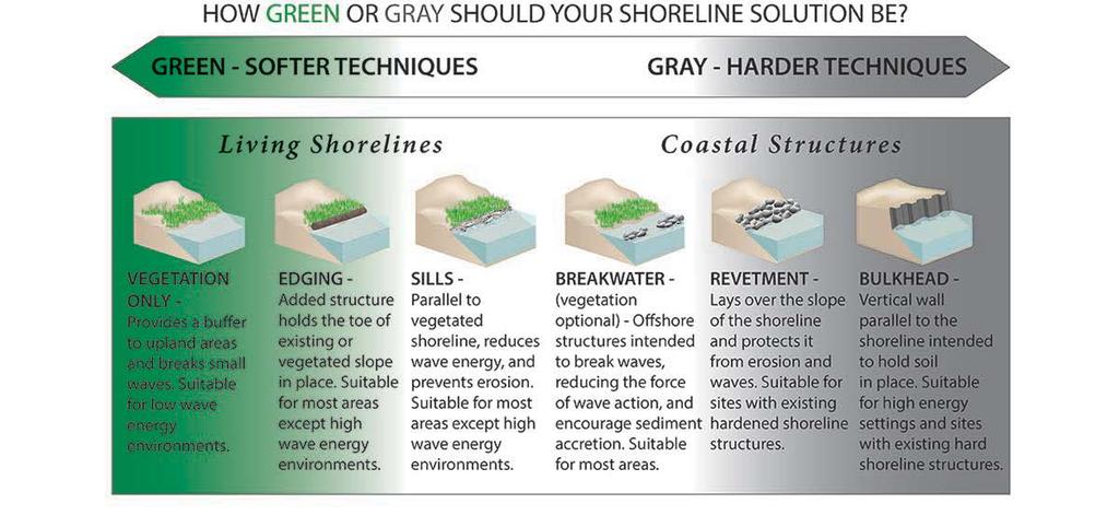
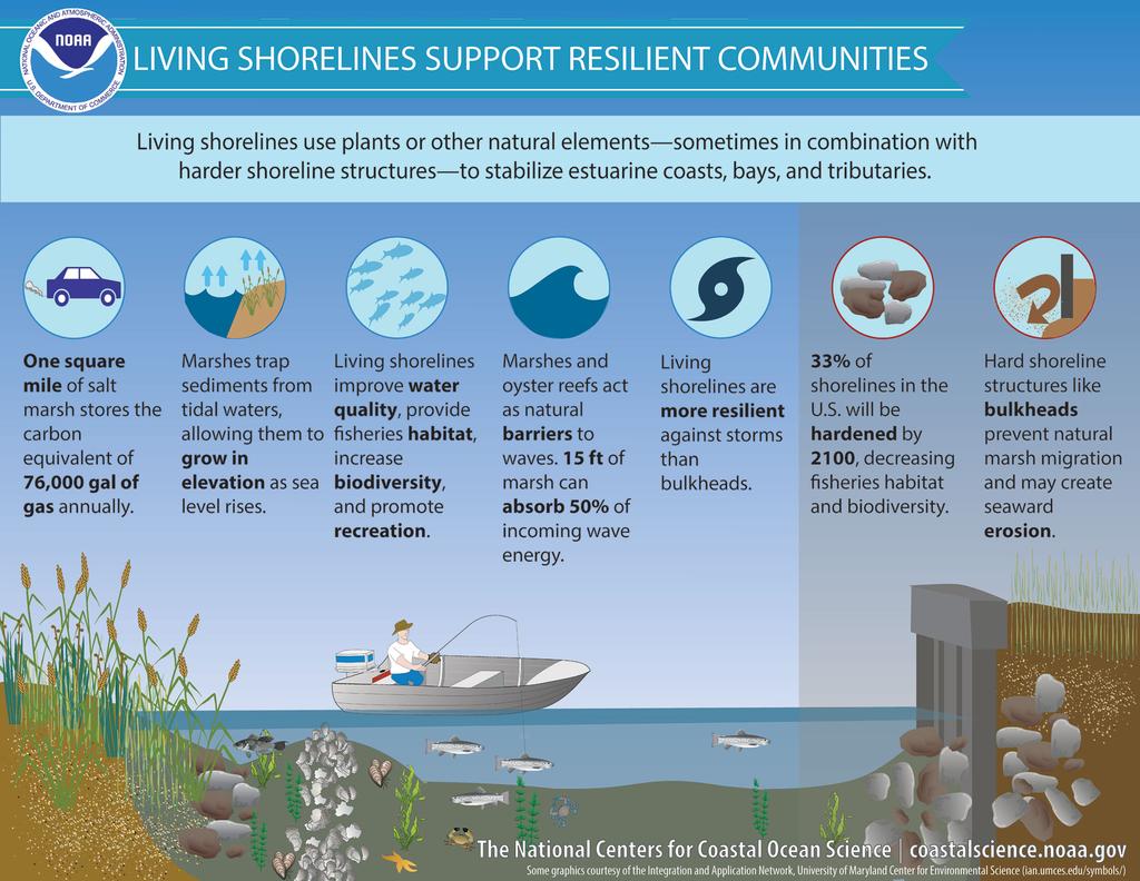
Estuarine Shoreline Stabilization
 Estuarine Shoreline Stabilization Property Owner s Guide to Determining the Most Appropriate Stabilization Method Estuarine shorelines are dynamic features that experience continued erosion. Land is lost
There are many different kinds of beaches which are generally characterized by the dominance of waves, tides, rivers and currents, and in particular
 Fig. 11-11, p. 253 There are many different kinds of beaches which are generally characterized by the dominance of waves, tides, rivers and currents, and in particular differ by the amount of energy, which
Ivan-like hurricane storm surge simulations for Tampa Bay, FL with 3-D and 2-D models
 Ivan-like hurricane storm surge simulations for Tampa Bay, FL with 3-D and 2-D models R.H. Weisberg and L. Zheng Storm Surge Workshop St. Pete Beach 2/11/09 Potential for Tampa Bay area inundation is large
consulting engineers and scientists
 consulting engineers and scientists Coastal Processes Presented by: January 9, 2015 Varoujan Hagopian, P.E. F.ASCE Senior Consultant, Waterfront Engineer Living Shoreline Workshop Lets Remember Why We
SURF ZONE HYDRODYNAMICS COMPARISON OF MODELLING AND FIELD DATA
 SURF ZONE HYDRODYNAMICS COMPARISON OF MODELLING AND FIELD DATA Nicholas Grunnet 1, Kévin Martins 2, Rolf Deigaard 3 and Nils Drønen 4 Field data from the NOURTEC project is used for comparison with simulation
Understanding the Tsunami Wave
 The First Tsunami attack on Sri Lanka Krakatoa Island 27 th August 1883 Understanding the Tsunami Wave Generation Propagation Nearshore Transformation Shoreline Entry Inland Dissipation 1 Generation and
Lecture Outlines PowerPoint. Chapter 15 Earth Science, 12e Tarbuck/Lutgens
 Lecture Outlines PowerPoint Chapter 15 Earth Science, 12e Tarbuck/Lutgens 2009 Pearson Prentice Hall This work is protected by United States copyright laws and is provided solely for the use of instructors
THE WAVE CLIMATE IN THE BELGIAN COASTAL ZONE
 THE WAVE CLIMATE IN THE BELGIAN COASTAL ZONE Toon Verwaest, Flanders Hydraulics Research, toon.verwaest@mow.vlaanderen.be Sarah Doorme, IMDC, sarah.doorme@imdc.be Kristof Verelst, Flanders Hydraulics Research,
MIKE Release General product news for Marine software products, tools & features. Nov 2018
 MIKE Release 2019 General product news for Marine software products, tools & features Nov 2018 DHI 2012 MIKE 3 Wave FM New advanced phase-resolving 3D wave modelling product A MIKE 3 FM Wave model - why?
Baraga County, MI Coastal Hazard Analysis Flood Risk Review Meeting. July 12, 2018
 Baraga County, MI Coastal Hazard Analysis Flood Risk Review Meeting July 12, 2018 Agenda Introductions Coastal Flood Risk Study and Mapping Program Current Status Technical Overview of Study and Mapping
The Islands. Barbados. A prefeasibility study. R. Drieman M. Hinborch M. Monden E.A.J. Vendrik
 The Islands Barbados A prefeasibility study R. Drieman M. Hinborch M. Monden E.A.J. Vendrik General notice to the reader: In the academic programme for Hydraulic Engineering we have in the 4th year (i.e.
Inlet Management Study for Pass-A-Grille and Bunces Pass, Pinellas County, Florida
 Inlet Management Study for Pass-A-Grille and Bunces Pass, Pinellas County, Florida Final Report Submitted By Ping Wang, Ph.D., Jun Cheng Ph.D., Zachary Westfall, and Mathieu Vallee Coastal Research Laboratory
INTRODUCTION TO COASTAL ENGINEERING AND MANAGEMENT
 Advanced Series on Ocean Engineering Volume 16 INTRODUCTION TO COASTAL ENGINEERING AND MANAGEMENT J. William Kamphuis Queen's University, Canada World Scientific Singapore New Jersey London Hong Kong Contents