Predicting wave conditions in a coral embayment from offshore directional spectral model input
|
|
|
- Jessie Page
- 5 years ago
- Views:
Transcription
1 Predicting wave conditions in a coral embayment from offshore directional spectral model input Ron Hoeke 1,2 and Curt Storlazzi 3 1 Coral Reef Ecosystem Division (CRED) NOAA Pacific Islands Fisheries Science Center 3 Coastal Marine Geology (CMG) USGS Pacific Science Center 2 School of Maths and Physics James Cook University

2 Study Location Map: Hanalei Bay, Island of Kauai, Hawaii

3 Dynamic Conditions Hanalei Bay Huge freshwater input, biggest waves and some of the smallest waves.. quite possibly the greatest range of conditions in the Hawaiian Islands. Hanalei River Outflow and Wave Height at Buoy Mt. Wai ale ale ale ale 1570m tall Average Rainfall: 9400 mm y -1 Mt. Wai ale ale

 to address land- based")
4 Hanalei Bay A major marine recreation area and famous tourist destination site. Its water uses include surfing, swimming, snorkeling, scuba, kayaking, sailing, outrigger canoe paddling, and fishing. 60% of Hawaii s s taro (Poi) crop Traditional Hawaiian cultural area Listed in the Environmental Protection Agency s s (EPA) 303d list of impaired waters One of the three priority ahupua`a for focused action by Hawai`i s Local Action Strategy (LAS) to address land- based pollution threats to coral reefs Hawaiian Islands Humpback Whale National Marine Sanctuary.


5 Motivation: Management concerns require estimates of: Flushing and overall circulation 1. Water quality/watershed management 2. sediment load/sediment transport 3. search and rescue Bed shear stress: 1. distribution of benthic habitats 2. catastrophic storm damage 3. nutrient availability Goal: implement a coupled wave/circulation model for Hanalei Bay

6 Preliminary Results Modeled Data Location of rips: ODP WALL

7 Location of rips: Figure 6 from Calhoun, Fletcher, and Harney, 2002.

8 Preliminary Caclulations: Estimation of volume flux 4m NW swell 2m NW swell tradewind swell
9 Preliminary Calculations: Estimation of flushing time Volume: V = 1.9 x 10 7 m3 Flushing (residence) time: R = V/U volume flux flushing time tides alone 55.2 m 3 s days tides + winds 232 m 3 s days Tradewind waves 467 m 3 s hours Modal NW Swell 1062 m 3 s hours NW Swell 2816 m 3 s hours

10 Preliminary Results: Estimation of Dislodgment Mechanical Threshold (DMT)* σ s DMT = 2 U ρ σ = 2 10 s 5 N m 2 Breakage occurs when Colony Shape Factor(CSF) * exceeds DMT: DMT CSF CSF ~ 300 * Madin JS and Connelly SR, Ecological consequences if major hydrodynamic disturbances on coral reefs. Nature 444:

11 Muck with the models: 1. Measure tidal constituents at boundaries 2. Develop realistic spatially heterogeneous roughness grid 3. Refine grid and take careful consideration of shoreline and depth datum 4. Domain decomposition? 5. 2D -> > 3D? Collect/analyze in-situ observations and compare to the model


12 Study Location Overview: K w = 0.05m King s Reef TIDE1 TIDE2 K w = 0.16m* ODP WALL LOWE, et al., Spectral wave dissipation over a barrier reef. Journal of Geophysical Research 110(C04001). HEARN, et al., A physical derivation of nutrient-uptake rates in coral reefs: Effects of roughness and waves, Coral Reefs, 20,

13 SWAN (Simulating WAves Nearshore) nested in NCEP s Wave Watch III ENP Spectral Output Nodes Methods: SWAN Kauai Grid Domain


14 Preliminary Results: In-Situ Data Spatial grid resolutions: 200m 100m 40m 30m 20m
15 Kings Reef Comparison of different spatial resolutions: ODP WALL Kings Reef ODP WALL

16 Kings Reef Comparison of different roughness schemes: ODP WALL Kings Reef ODP WALL
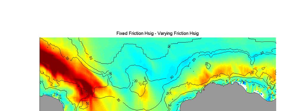

17 Hs difference (m)
18 Setup/setdown difference (cm)

19


20 Typical Hawaiian forereefs: lots of different roughness scales
21 Conclusions: 1. Refraction/diffraction effects are especially important over coral reefs and poorly modeled with existing phase-averaged averaged models 2. At tested spatial scales, SWAN s solutions consistently under predict near-shore wave height and refraction but improve with increasing spatial resolution 3. Spatially varying bottom roughness is essential for realistic results but how best to go about it? CAN waves on coral reefs be modeled at spatial resolutions lower than the individual roughness elements on the reef (e.g m)? 5m)?
Wave energy converter effects on wave and sediment circulation
 Wave energy converter effects on wave and sediment circulation Grace Chang and Craig Jones Integral Consulting Inc. cjones@integral-corp.com; gchang@integral-corp.com Jesse Roberts, Kelley Ruehl, and Chris
Effects of Offshore Forcing in the Nearshore Environment
 Effects of Offshore Forcing in the Nearshore Environment Geno Pawlak Department of Ocean and Resources Engineering University of Hawaii at Manoa 2540 Dole St., Holmes Hall 402 Honolulu, HI 96822 phone:
Wave research at Department of Oceanography, University of Hawai i
 Wave research at Department of Oceanography, University of Hawai i Hawaii wave climate. Directional waverider buoys around Hawaii. Past and present wave-related research projects. Effect of tides on wave
Coastal Sediment Transport Modeling Ocean Beach & San Francisco Bight, CA
 1 Coastal Sediment Transport Modeling Ocean Beach & San Francisco Bight, CA Honghai Li and Lihwa Lin Engineering Research and Development Center U.S. Army Corps of Engineers Frank Wu, Lisa Andes, and James
Coastal Wave Energy Dissipation: Observations and Modeling
 Coastal Wave Energy Dissipation: Observations and Modeling Jeffrey L Hanson US Army Corps of Engineers Field Research Facility USACE Field Research Facility Kent K. Hathaway US Army Corps of Engineers
An Investigation of the Influence of Waves on Sediment Processes in Skagit Bay
 DISTRIBUTION STATEMENT A. Approved for public release; distribution is unlimited. An Investigation of the Influence of Waves on Sediment Processes in Skagit Bay Geoffrey W. Cowles School for Marine Science
Wave Transformation Modeling with Bottom Friction Applied to the Southeast Oahu Reefs. Mary A. Cialone and Jane McKee Smith
 Wave Transformation Modeling with Bottom Friction Applied to the Southeast Oahu Reefs Mary A. Cialone and Jane McKee Smith Outline Objective Study Area STWAVE Friction Formulations Model Validation Summary
DUXBURY WAVE MODELING STUDY
 DUXBURY WAVE MODELING STUDY 2008 Status Report Duncan M. FitzGerald Peter S. Rosen Boston University Northeaster University Boston, MA 02215 Boston, MA 02115 Submitted to: DUXBURY BEACH RESERVATION November
Hydrodynamics of a bathymetrically complex fringing coral reef embayment: Wave climate, in situ observations, and wave prediction
 JOURNAL OF GEOPHYSICAL RESEARCH, VOL. 116,, doi:10.1029/2010jc006170, 2011 Hydrodynamics of a bathymetrically complex fringing coral reef embayment: Wave climate, in situ observations, and wave prediction
THE WAVE CLIMATE IN THE BELGIAN COASTAL ZONE
 THE WAVE CLIMATE IN THE BELGIAN COASTAL ZONE Toon Verwaest, Flanders Hydraulics Research, toon.verwaest@mow.vlaanderen.be Sarah Doorme, IMDC, sarah.doorme@imdc.be Kristof Verelst, Flanders Hydraulics Research,
Coastal and marine recreation in New England is ingrained in the region s economic and
 RECREATION Coastal and marine recreation in New England is ingrained in the region s economic and social fabric. Recreation on the ocean and coast includes many of New Englanders most time-honored and
Mechanisms and Characteristics of High-Speed Reef Rip Current
 Mechanisms and Characteristics of High-Speed Reef Rip Current Ryuichiro Nishi, Mario P. de Leon, Kouji Horinouchi,Akira Ohtani, Nicholas C. Kraus, and Julianti K. Manu Many people utilize beaches, but
Prediction of Nearshore Waves and Currents: Model Sensitivity, Confidence and Assimilation
 Prediction of Nearshore Waves and Currents: Model Sensitivity, Confidence and Assimilation H. Tuba Özkan-Haller College of Oceanic and Atmospheric Sciences Oregon State University, 104 Ocean Admin Bldg
Assessment of flooding on low-elevation reef-lined coasts
 Assessment of flooding on low-elevation reef-lined coasts Ap van Dongeren, Deltares, Delft, The Netherlands With Curt Storlazzi, USGS, Santa Cruz, USA Impact on coral reef-lined islands and coasts Coral
Beach Wizard: Development of an Operational Nowcast, Short-Term Forecast System for Nearshore Hydrodynamics and Bathymetric Evolution
 Beach Wizard: Development of an Operational Nowcast, Short-Term Forecast System for Nearshore Hydrodynamics and Bathymetric Evolution Ad Reniers Civil Engineering and Geosciences, Delft University of Technology
CALCASIEU SALINITY STRUCTURES. HYDRODYNAMIC MODELING (To Support Design of Salinity Barriers)
") CALCASIEU SALINITY STRUCTURES HYDRODYNAMIC MODELING (To Support Design of Salinity Barriers) Presentation Overview 1 2 3 4 5 Project Overview and CEA Circulation Modeling Vessel Hydrodynamics Modeling
CALCASIEU SALINITY STRUCTURES HYDRODYNAMIC MODELING (To Support Design of Salinity Barriers) Presentation Overview 1 2 3 4 5 Project Overview and CEA Circulation Modeling Vessel Hydrodynamics Modeling
CMS Modeling of the North Coast of Puerto Rico
 CMS Modeling of the North Coast of Puerto Rico PRESENTED BY: Dr. Kelly Rankin Legault, Ph.D., P.E. 1 Dr. Alfredo Torruella, Ph.D. 2 1 USACE Jacksonville District 2 University of Puerto Rico October 2016
OECS Regional Engineering Workshop September 29 October 3, 2014
 B E A C H E S. M A R I N A S. D E S I G N. C O N S T R U C T I O N. OECS Regional Engineering Workshop September 29 October 3, 2014 Coastal Erosion and Sea Defense: Introduction to Coastal Dynamics David
Marine Renewables Industry Association. Marine Renewables Industry: Requirements for Oceanographic Measurements, Data Processing and Modelling
 Marine Renewables Industry Association Marine Renewables Industry: Requirements for Oceanographic Measurements, Data Processing and Modelling October 2009 Table of Contents 1. Introduction... 1 2. Measurements
IMPACTS OF COASTAL PROTECTION STRATEGIES ON THE COASTS OF CRETE: NUMERICAL EXPERIMENTS
 IMPACTS OF COASTAL PROTECTION STRATEGIES ON THE COASTS OF CRETE: NUMERICAL EXPERIMENTS Tsanis, I.K., Saied, U.M., Valavanis V. Department of Environmental Engineering, Technical University of Crete, Chania,
Modeling changes to the historic Lower Columbia River Estuary using Delft3D. Drew Mahedy Lumas Helaire Stefan Talke David Jay May 30, 2014
 Modeling changes to the historic Lower Columbia River Estuary using Delft3D Drew Mahedy Lumas Helaire Stefan Talke David Jay May 30, 2014 Comparison: Historic and Modern LCRE US Coastal Survey, 1868 Historic
Land Use Planning in Maui, Hawaii to Prevent Sedimentation of Fringing Coral Reefs
 Land Use Planning in Maui, Hawaii to Prevent Sedimentation of Fringing Coral Reefs By Kathryn M. Crane Dr. Michael K. Orbach, Advisor May 2011 Masters project submitted in partial fulfillment of the requirements
Wave Energy Research and Applications
 Wave Energy Research and Applications Shoreline and Shallows conference East Lansing, MI March 7, 2019 Photo: Dave Sanford Waves Background 1. Types of Waves 2. Good and Bad Waves 3. Restoration Impacts
SURF ZONE HYDRODYNAMICS COMPARISON OF MODELLING AND FIELD DATA
 SURF ZONE HYDRODYNAMICS COMPARISON OF MODELLING AND FIELD DATA Nicholas Grunnet 1, Kévin Martins 2, Rolf Deigaard 3 and Nils Drønen 4 Field data from the NOURTEC project is used for comparison with simulation
Name Class Date. Use the terms from the following list to complete the sentences below. Each term may be used only once. Some terms may not be used.
 Assessment Chapter Test B The Movement of Ocean Water USING KEY TERMS Use the terms from the following list to complete the sentences below. Each term may be used only once. Some terms may not be used.
COASTAL MORPHODYNAMICS
 COASTAL MORPHODYNAMICS PATRICIA CHARDÓN-MALDONADO, PHD, EIT Miguel Canals, Jack A. Puleo, Alec Torres-Freyermuth & Jens Figlus March 9, 2017 OUTLINE INTRODUCTION Meteorological Phenomena Forcing Conditions
Evaluation of a proposed solution to beach erosion at Negril
 Mondon, E. M. and Warner, P.S. 2012. Evaluation of a proposed solution to beach erosion at Negril. Caribbean Journal of Earth Science, Volume 43, 11-23. Available online: 2 nd July 2012. Geological Society
BEFORE THE ENVIRONMENTAL PROTECTION AUTHORITY. of an Application under Section 38 of the Act for Marine Consents by Trans-Tasman Resources Limited
 BEFORE THE ENVIRONMENTAL PROTECTION AUTHORITY IN THE MATTER of the Exclusive Economic Zone and Continental Shelf (Environmental Effects) Act 2012 AND IN THE MATTER of an Application under Section 38 of
An Investigation of the Influence of Waves on Sediment Processes in Skagit Bay
 DISTRIBUTION STATEMENT A. Approved for public release; distribution is unlimited. An Investigation of the Influence of Waves on Sediment Processes in Skagit Bay Geoffrey W. Cowles School for Marine Science
Generalized Wave-Ray Approach for Propagation on a Sphere and Its Application to Swell Prediction
 Generalized Wave-Ray Approach for Propagation on a Sphere and Its Application to Swell Prediction D. Scott 1, D. Resio 2, and D. Williamson 1 1. & Associates 2. Coastal Hydraulic Laboratory, U.S. Army
Surface Wave Dynamics in the Coastal Zone
 DISTRIBUTION STATEMENT A. Approved for public release; distribution is unlimited. Surface Wave Dynamics in the Coastal Zone Gerbrant Ph. van Vledder Department of Civil engineering and Geosciences, Delft
ABSTRACT. KEY WORDS: Navigation safety; numerical modeling; waves; current; sediment transport; channel infilling; morphology change.
 The 25th (2015) International Polar and Engineering Conference Li, H., L. Lin, Z. Demirbilek, T. M. Beck, and H. R. Moritz (2015). Wave-Current Conditions and Navigation Safety at an Inlet Entrance. The
Directional Wave Spectra from Video Images Data and SWAN Model. Keywords: Directional wave spectra; SWAN; video images; pixels
 Jurnal Teknologi Full paper Directional Wave Spectra from Video Images Data and SWAN Model Muhammad Zikra a*, Noriaki Hashimoto b, Masaru Yamashiro b, Kojiro Suzuki c a Department of Ocean Engineering,
Appendix D: SWAN Wave Modelling
 Appendix D: SWAN Wave Modelling D.1 Preamble The Eurobodalla Shire Council area is subject to extreme waves originating from offshore storms. When swell waves approach the coast, they are modified by the
Evaluation of Unstructured WAVEWATCH III for Nearshore Application
 Evaluation of Unstructured WAVEWATCH III for Nearshore Application Jane McKee Smith, Tyler Hesser, Mary Anderson Bryant USACE Research and Development Center, Coastal and Hydraulics Lab Aron Roland BGS
City of Del Mar Local Coastal Plan (LCP) Amendment for Sea Level Rise and Coastal Flooding
 Amendment for Sea Level Rise and Coastal Flooding") City of Del Mar Local Coastal Plan (LCP) Amendment for Sea Level Rise and Coastal Flooding 6/22/17 Presentation to Sea Level Rise Stakeholder- Technical Advisory Committee (STAC) Nick Garrity, P.E. Lindsey
City of Del Mar Local Coastal Plan (LCP) Amendment for Sea Level Rise and Coastal Flooding 6/22/17 Presentation to Sea Level Rise Stakeholder- Technical Advisory Committee (STAC) Nick Garrity, P.E. Lindsey
The Sand Beaches of New Hampshire and Maine
 The Sand Beaches of New Hampshire and Maine Beach Preservation and Erosion Control Photographs provided by Joe Kelly and Steve Adams Cover photo: Reid State Park, ME Introduction The sand beaches of New
Observed and simulated wavetide interaction in a region of. high tidal flow
 Observed and simulated wavetide interaction in a region of high tidal flow Lewis M*; Chang W; Neill S; Robins P; Hashemi R;Ward S; Piano M * m.j.lewis@bangor.ac.uk (1/12) Summary Dynamically coupled wave-tide
Pathogen Transport in Coastal Environments: Case Studies of Urban Runoff in Southern California
 Pathogen Transport in Coastal Environments: Case Studies of Urban Runoff in Southern California A presentation to the Center for Water Sciences MSU Pathogens Workshop, April 20, 2007 Stanley B. Grant Henry
Monitoring tidal movements in Cook Inlet, Alaska, using the integration of remote sensing data, GIS, and inundation models
 Monitoring tidal movements in Cook Inlet, Alaska, using the integration of remote sensing data, GIS, and inundation models Hua Liu Department of political Science and Geography Old Dominion University
G. Meadows, H. Purcell and L. Meadows University of Michigan
 www.coj.net/departments/fire+and+rescue/emergency+preparedness/rip+current.htm G. Meadows, H. Purcell and L. Meadows Over 80% of all surf related rescues are attributable to Rip Currents According to the
Development and Implementation of a Relocatable Coastal and Nearshore Modeling System
 Development and Implementation of a Relocatable Coastal and Nearshore Modeling System James M. Kaihatu Zachry Department of Civil Engineering, Texas A&M University 3136 TAMU College Station, TX 77843-3136
INTRODUCTION TO COASTAL ENGINEERING AND MANAGEMENT
 Advanced Series on Ocean Engineering Volume 16 INTRODUCTION TO COASTAL ENGINEERING AND MANAGEMENT J. William Kamphuis Queen's University, Canada World Scientific Singapore New Jersey London Hong Kong Contents
An IOOS Operational Wave Observation Plan Supported by NOAA IOOS Program & USACE
 An IOOS Operational Wave Observation Plan Supported by NOAA IOOS Program & USACE R.E. Jensen, W.A. Birkemeier and W. Burnett JCOMM-Workshop on Wave Measurements from Buoys Wave Information to Application
Ocean Waves and Surf Forecasting: Wave Climate and Forecasting
 Overview Ocean Waves and Surf Forecasting: Wave Climate and Forecasting Ocean regions Characterizing and describing ocean waves Wave theory, propagation, and dispersion Refraction, shadowing, and bathymetry
Beach Profiles. Topics. Module 9b Beach Profiles and Crossshore Sediment Transport 3/23/2016. CE A676 Coastal Engineering
 Beach Profiles AND CROSS-SHORE TRANSPORT Orson P. Smith, PE, Ph.D., Professor Emeritus Topics Features of beach and nearshore profiles Equilibrium profiles Cross-shore transport References Text (Sorensen)
Tidal modulation of wave-setup and wave-induced currents on the Aboré coral reef, New Caledonia
 18th April 2007 Tidal modulation of wave-setup and wave-induced currents on the Aboré coral reef, New Caledonia Philippe BONNETON, Jean-Pierre LEFEBVRE, Patrice BRETEL, Sylvain OUILLON, Pascal DOUILLET
THE EFFECT OF HINDCASTED WAVES ON COASTAL STORM WATER LEVELS DURING THE BLIZZARD OF 2003
 THE EFFECT OF HINDCASTED WAVES ON COASTAL STORM WATER LEVELS DURING THE BLIZZARD OF 2003 Jennifer L. Irish US Army Corps of Engineers New York District and North Atlantic Division New York, New York, USA
Swell and Wave Forecasting
 Lecture 25 Swell and Wave Forecasting Swell and Wave Forecasting Motivation Terminology Wave Formation Wave Decay Wave Refraction Shoaling Rouge Waves 1 2 Motivation In Hawaii, surf is the number one weather-related
Swell and Wave Forecasting
 Lecture 24 Part II Swell and Wave Forecasting 29 Swell and Wave Forecasting Motivation Terminology Wave Formation Wave Decay Wave Refraction Shoaling Rouge Waves 30 Motivation In Hawaii, surf is the number
National Marine Fisheries Service, Habitat Conservation Division:
 National Marine Fisheries Service, Habitat Conservation Division: Essential Fish Habitat, South East Florida Coral Reef Initiative and Land- Based Sources of Pollution effects on Critical Fisheries Habitats
Habitat Fact Sheets. Rocky habitats are dominated by seaweeds and often mussels, which rely on the rocks for attachment.
 Habitat Fact Sheets Habitats in the Gulf of Maine serve many important roles for the environment and for humans as well. These include: cycling nutrients, filtering pollution, trapping sediments, storing
Wave Transformation, Prediction, and Analysis at Kaumalapau Harbor, Lanai, Hawaii
 Wave Transformation, Prediction, and Analysis at Kaumalapau Harbor, Lanai, Hawaii Jessica H. Podoski, P.E. Coastal Engineer, USACE Honolulu District Christopher Goody, P.E. Sea Engineering, Inc. Thomas
MODELLING WAVE-TIDE INTERACTIONS AT A WAVE FARM IN THE SOUTHWEST OF ENGLAND
 MODELLING WAVE-TIDE INTERACTIONS AT A WAVE FARM IN THE SOUTHWEST OF ENGLAND Raúl González-Santamaría 1, Qingping Zou 1, Shunqi Pan 1, Roberto Padilla-Hernandez 2 The Wave Hub project will create the world
Evaluation of June 9, 2014 Federal Emergency Management Agency Flood Insurance Study for Town of Weymouth, Norfolk, Co, MA
 Evaluation of June 9, 2014 Federal Emergency Management Agency Flood Insurance Study for Town of Weymouth, Norfolk, Co, MA Prepared For: Woodard & Curran 95 Cedar Street, Suite 100 Providence, RI 02903
WIND SPEED LENGTH OF TIME WIND BLOWS (Duration) DISTANCE OVER WHICH IT BLOWS (Fetch)
 DISTANCE OVER WHICH IT BLOWS (Fetch)") WAVES Up and down movement of ocean surface Transportation of energy across the water over vast distances If not stopped by anything, waves can travel entire oceans Size and speed depend upon: WIND SPEED
WAVES Up and down movement of ocean surface Transportation of energy across the water over vast distances If not stopped by anything, waves can travel entire oceans Size and speed depend upon: WIND SPEED
Puget Sound Nearshore Ecosystem Restoration Project Restore America s Estuaries Conference 2012 Tampa, FL
 Restore America s Estuaries Conference 2012 Tampa, FL presented by: Theresa Mitchell, WA Dept. of Fish & Wildlife Nearshore General Investigation Change Analysis: Comparison of historical and current
Effect of Hydrodynamics on Sediment Transport near a Coastal Inlet
 ICHE 2014, Hamburg - Lehfeldt & Kopmann (eds) - 2014 Bundesanstalt für Wasserbau ISBN 978-3-939230-32-8 Effect of Hydrodynamics on Sediment Transport near a Coastal Inlet H. Li, M. Brown, J. Rosati & Z.
Nearshore Morphodynamics. Bars and Nearshore Bathymetry. Sediment packages parallel to shore, that store beach sediment
 Nearshore Morphodynamics http://coastal.er.usgs.gov/bier/images/chandeleur-xbeach-lg.jpg Bars and Nearshore Bathymetry Sediment packages parallel to shore, that store beach sediment Can be up to 50 km
WAVE PREDICTIONS AT THE SITE OF A WAVE ENERGY CONVERSION ARRAY
 WAVE PREDICTIONS AT THE SITE OF A WAVE ENERGY CONVERSION ARRAY Jeffrey A. Oskamp 1 and H. Tuba, Özkan-Haller 2 The SWAN spectral wave model was applied to a domain along the coast of Oregon State, USA
The Maritime Law Association of Australia and New Zealand
 The Maritime Law Association of Australia and New Zealand Protecting the Environment and Promoting Safe Navigation: Australia s System of Pilotage in the Torres Strait Adam McCarthy Assistant Secretary
Coastal Wave Studies FY13 Summary Report
 DISTRIBUTION STATEMENT A. Approved for public release; distribution is unlimited. Coastal Wave Studies FY13 Summary Report Jeffrey L. Hanson US Army Corps of Engineers, Field Research Facility 1261 Duck
Effective multi-agency collaboration improves spatial monitoring and planning in the Florida Keys
 Effective multi-agency collaboration improves spatial monitoring and planning in the Florida Keys Jim Bohnsack Southeast Fisheries Science Center NOAA Fisheries Service Miami, FL 1 The Managed Florida
Morphological Evolution Near an Inlet
 DISTRIBUTION STATEMENT A. Approved for public release; distribution is unlimited. Morphological Evolution Near an Inlet Steve Elgar Woods Hole Oceanographic Institution, MS11 Woods Hole, MA 02543 phone:
Passage Key Inlet, Florida; CMS Modeling and Borrow Site Impact Analysis
 Passage Key Inlet, Florida; CMS Modeling and Borrow Site Impact Analysis by Kelly R. Legault and Sirisha Rayaprolu PURPOSE: This Coastal and Hydraulics Engineering Technical Note (CHETN) describes the
Training program on Modelling: A Case study Hydro-dynamic Model of Zanzibar channel
 Training program on Modelling: A Case study Hydro-dynamic Model of Zanzibar channel Mayorga-Adame,C.G., Sanga,I.P.L., Majuto, C., Makame, M.A., Garu,M. INTRODUCTION Hydrodynamic Modeling In understanding
Three point plan to addressing land use and habitat loss impacts on Chesapeake Bay tidal fish and shellfish
 Three point plan to addressing land use and habitat loss impacts on Chesapeake Bay tidal fish and shellfish 1. Establish Principles for Protection of Chesapeake Bay Fish and Shellfish The Fisheries GIT
Three-dimensional High-resolution Numerical Study of the Tide and Tidal Current in the Jiaozhou Bay and Olympic Sailing Site
 Three-dimensional High-resolution Numerical Study of the Tide and Tidal Current in the Jiaozhou Bay and Olympic Sailing Site By Jinrui Chen Ocean University of China cooperator: Shiliang Shan, Huaming
Determination of Nearshore Wave Conditions and Bathymetry from X-Band Radar Systems
 Determination of Nearshore Wave Conditions and Bathymetry from X-Band Radar Systems Okey G. Nwogu Dept. of Naval Architecture and Marine Engineering University of Michigan Ann Arbor, MI 48109 Phone: (734)
Nearshore Dredged Material Placement Pilot Study at Noyo Harbor, CA
 1 Nearshore Dredged Material Placement Pilot Study at Noyo Harbor, CA Noyo Cove N 2011 National Conference on Beach Preservation Technology 9-11, February 2011 Lihwa Lin, Honghai Li, Mitchell Brown US
no-take zone 1 of 5 Channel Islands National Marine Sanctuary, California
 This website would like to remind you: Your browser (Apple Safari 4) is out of date. Update your browser for more security, comfort and the best experience on this site. Encyclopedic Entry no-take zone
Morphological constraints to wave driven circulation in coastal reef lagoon systems: A numerical study
 JOURNAL OF GEOPHYSICAL RESEARCH, VOL. 115,, doi:10.1029/2009jc005753, 2010 Morphological constraints to wave driven circulation in coastal reef lagoon systems: A numerical study Ryan J. Lowe, 1 Colin Hart,
Implementation of the new French operational coastal wave forecasting system and application to a wavecurrent interaction study
 14 th International Workshop on Wave Hindcasting and Forecasting Implementation of the new French operational coastal wave forecasting system and application to a wavecurrent interaction study H. Michaud
Interactions of Waves and River Plume and their Effects on Sediment Transport at River Mouth
 DISTRIBUTION STATEMENT A. Approved for public release; distribution is unlimited. Interactions of Waves and River Plume and their Effects on Sediment Transport at River Mouth Tian-Jian Hsu and Fengyan
A Curriculum on Division of Boating and Ocean Recreation (DOBOR) Rules
 Rules") A Curriculum on Division of Boating and Ocean Recreation (DOBOR) Rules Boating Rules Education Registration Use Permits Day Moorings Boating equipment requirements Special Water Activities Thrill Craft
A Curriculum on Division of Boating and Ocean Recreation (DOBOR) Rules Boating Rules Education Registration Use Permits Day Moorings Boating equipment requirements Special Water Activities Thrill Craft
CROSS-SHORE SEDIMENT PROCESSES
 The University of the West Indies Organization of American States PROFESSIONAL DEVELOPMENT PROGRAMME: COASTAL INFRASTRUCTURE DESIGN, CONSTRUCTION AND MAINTENANCE A COURSE IN COASTAL DEFENSE SYSTEMS I CHAPTER
Wave-driven circulation in a coastal bay during the landfall of a hurricane
 Click Here for Full Article JOURNAL OF GEOPHYSICAL RESEARCH, VOL. 113,, doi:10.1029/2007jc004500, 2008 Wave-driven circulation in a coastal bay during the landfall of a hurricane Ryan P. Mulligan, 1 Alex
Modeling 3D circulation in the Choctawhatchee Bay and River System
 Modeling 3D circulation in the Choctawhatchee Bay and River System Rosemary Cyriac 1, Casey Dietrich 1, Arash Fathi 2, Clint Dawson 2, Kendra Dresback 3, Cheryl Ann Blain 4, Matthew Bilskie 5, Scott Hagen
Understanding the Tsunami Wave
 The First Tsunami attack on Sri Lanka Krakatoa Island 27 th August 1883 Understanding the Tsunami Wave Generation Propagation Nearshore Transformation Shoreline Entry Inland Dissipation 1 Generation and
Indian River Lagoon: Lessons, Challenges and Opportunities
 Indian River Lagoon: Lessons, Challenges and Opportunities Upper Chain of Lakes Lake Kissimmee Kissimmee River Indian River Lagoon Caloosahatchee Estuary Lake Okeechobee St. Lucie Estuary Mark Perry, Executive
A PRACTICAL APPROACH TO MAPPING EXTREME WAVE INUNDATION: CONSEQUENCES OF SEA-LEVEL RISE AND COASTAL EROSION.
 A PRACTICAL APPROACH TO MAPPING EXTREME WAVE INUNDATION: CONSEQUENCES OF SEA-LEVEL RISE AND COASTAL EROSION. Sean Vitousek 1, Charles H. Fletcher 1, Matthew M. Barbee 1 1. Department of Geology and Geophysics,
OCEAN WAVES NAME. I. Introduction
 NAME OCEAN WAVES I. Introduction The physical definition of a wave is a disturbance that transmits energy from one place to another. In the open ocean waves are formed when wis blowing across the water
Improving predictions of nearshore processes and shoreline dynamics for beaches along Australia s rocky and coral reef coasts
 Improving predictions of nearshore processes and shoreline dynamics for beaches along Australia s rocky and coral reef coasts Ryan Lowe Jeff Hansen, Graham Symonds, Mark Buckley, Andrew Pomeroy, Gundula
The impact of ocean bottom morphology on the modelling of long gravity waves from tides and tsunami to climate
 The impact of ocean bottom morphology on the modelling of long gravity waves from tides and tsunami to climate Christian Le Provost and Florent Lyard Laboratoire d Etudes en Géophysique et Océanographie
Marginal Marine Environments
 Marginal Marine Environments Delta: discrete shoreline protuberances formed where rivers enter oceans, semi-enclosed seas, lakes or lagoons and supply sediment more rapidly than it can be redistributed
INTRODUCTION TO COASTAL ENGINEERING
 The University of the West Indies Organization of American States PROFESSIONAL DEVELOPMENT PROGRAMME: COASTAL INFRASTRUCTURE DESIGN, CONSTRUCTION AND MAINTENANCE A COURSE IN COASTAL DEFENSE SYSTEMS I CHAPTER
There are many different kinds of beaches which are generally characterized by the dominance of waves, tides, rivers and currents, and in particular
 Fig. 11-11, p. 253 There are many different kinds of beaches which are generally characterized by the dominance of waves, tides, rivers and currents, and in particular differ by the amount of energy, which
Chronic coastal erosion is a statewide problem
 Chronic coastal erosion is a statewide problem 1 Seawalls are constructed where there is erosion, but they do not solve the erosion they often worsen it along adjacent shores. Hawaii needs erosion solutions.
Louisiana s 2012 Coastal Master Plan BARRIER SHORELINE MORPHOLOGY MODEL
 Louisiana Coastal Protection & Restorat coastal.louisiana.gov Louisiana s 2012 Coastal Master Plan PREDICTIVE MODELING: committed to our coast BARRIER SHORELINE MORPHOLOGY MODEL Dallon Weathers, University
Undertow - Zonation of Flow in Broken Wave Bores
 Nearshore Circulation Undertow and Rip Cells Undertow - Zonation of Flow in Broken Wave Bores In the wave breaking process, the landward transfer of water, associated with bore and surface roller decay
Nearshore Waves and Erosion Model Quantifying the Coastal Protection Benefits Provided by Natural Habitats
 Nearshore Waves and Erosion Model Quantifying the Coastal Protection Benefits Provided by Natural Habitats SaveGuanaCayReef Marinehindsight.com Necessary to quantify protection services offered by natural
Tidal regime along Vietnam coast under impacts of sea level rise
 VNU Journal of Science, Earth Sciences 28 (2012) 133-139 Tidal regime along Vietnam coast under impacts of sea level rise Tran Thuc, Duong Hong Son* Vietnam Institute of Meteorology, Hydrology and Environment
Determination Of Nearshore Wave Conditions And Bathymetry From X-Band Radar Systems
 Determination Of Nearshore Wave Conditions And Bathymetry From X-Band Radar Systems Okey G. Nwogu Dept. of Naval Architecture and Marine Engineering University of Michigan Ann Arbor, MI 489 phone: (734)
Essential Fish Habitat OCNMS Advisory Council July 13, 2013
 Essential Fish Habitat OCNMS Advisory Council July 13, 2013 John Stadler Habitat Conservation Division NMFS Northwest Region Essential Fish Habitat (EFH) What is it, where did it come from, and what does
Model Predictions and Sensitivity Analysis of Nearshore Processes over Complex Bathymetry
 Model Predictions and Sensitivity Analysis of Nearshore Processes over Complex Bathymetry James M. Kaihatu Code 7322 Oceanography Division Naval Research Laboratory Stennis Space Center, MS William C.
RIP CURRENTS. Award # N
 RIP CURRENTS Graham Symonds School of Geography and Oceanography University College, University of New South Wales, Australian Defence Force Academy, Canberra, 2600 AUSTRALIA Phone: 61-6-2688289 Fax: 61-6-2688313
Shoreline Evolution Due to Oblique Waves in Presence of Submerged Breakwaters. Nima Zakeri (Corresponding Author), Mojtaba Tajziehchi
, Mojtaba Tajziehchi") Shoreline Evolution Due to Oblique Waves in Presence of Submerged Breakwaters Nima Zakeri (Corresponding Author), Mojtaba Tajziehchi Department of Civil Engineering, Faculty of Engineering, University
Shoreline Evolution Due to Oblique Waves in Presence of Submerged Breakwaters Nima Zakeri (Corresponding Author), Mojtaba Tajziehchi Department of Civil Engineering, Faculty of Engineering, University
APPENDIX N. CORALS LISTING
 APPENDI N. CORALS LISTING MUNITIONS RESPONSE SITES MRS 02 AND MRS 07 PHASE 2 UNDERWATER RI/FS CULEBRA ISLAND SITE, PUERTO RICO APPENDI N. CORALS LISTING This appendix contains a copy of the NOAA Fisheries
Computational Analysis of Oil Spill in Shallow Water due to Wave and Tidal Motion Madhu Agrawal Durai Dakshinamoorthy
 Computational Analysis of Oil Spill in Shallow Water due to Wave and Tidal Motion Madhu Agrawal Durai Dakshinamoorthy 1 OUTLINE Overview of Oil Spill & its Impact Technical Challenges for Modeling Review
Marine Ecosystems. Aquatic Ecosystems Section 2
 Marine Ecosystems Marine ecosystems are located mainly in coastal areas and in the open ocean. Organisms that live in coastal areas adapt to changes in water level and salinity. Organisms that live in