Modeling 3D circulation in the Choctawhatchee Bay and River System
|
|
|
- Lester Hall
- 5 years ago
- Views:
Transcription
1 Modeling 3D circulation in the Choctawhatchee Bay and River System Rosemary Cyriac 1, Casey Dietrich 1, Arash Fathi 2, Clint Dawson 2, Kendra Dresback 3, Cheryl Ann Blain 4, Matthew Bilskie 5, Scott Hagen 5, Hans Graber 6 1 N o rth C a rolina S tate U niversity 2 University o f Texas a t A ust in 3 U niversity o f O k lahoma 4 N aval Re search L aboratory 5 L ousiana S tate U niversity 6 University o f Miami Image Courtesy: CARTHE
 Image Courtesy: pubs.usgs.gov/sir/2006/5287/pdf/choctawhatcheebay.")
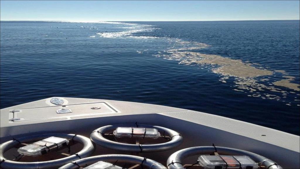
2 Study Area: Choctawhatchee Bay and River System An estuary is a semi-enclosed coastal body of water which has free connection to the open sea and within which sea water is measurably diluted with fresh water derived from land drainage. (Cameron and Pritchard 1993) Image Courtesy: pubs.usgs.gov/sir/2006/5287/pdf/choctawhatcheebay.pdf Series of experiments performed by CARTHE scientists in December 2013 to study near-shore oil transport characteristics Surfzone Coastal Oil Pathways Experiment (SCOPE) Annual mean river discharge is ~240 m 3 /s STUDY AREA 2


3 Image Courtesy: COSMO-SkyMed Product ASI 2013 processed under license from ASI Agenzia Spaziale Italiana. All rights reserved. Distributed by e-geos. Downlinked and processed by CSTARS. SCOPE Satellite Imagery 3


4 SCOPE CTD Profiles 12/06/ :17:48 12/16/ :30:03 12/16/ :26:28 4
5 Research Objectives To explore available experimental data to understand the hydrodynamics within Choctawhatchee Bay and the behavior of the near-shore ocean currents in the vicinity of the bay To develop barotropic and baroclinic modeling capabilities to predict the 3D flow characteristics within the Bay and in the near-shore region Starting with barotropic modeling using ADCIRC (2DDI and 3D) Future work: Implementing ADCIRC 3D baroclinic To model the influence of the incoming freshwater discharge from Choctawhatchee River on the 3D flow characteristics within the bay Starting with adding resolution to an existing ADCIRC mesh along the Choctawhatchee River Future work: Implementing river boundary condition and modeling incoming freshwater discharge into the bay To model the spatial extent and behavior of the freshwater plume coming out through the inlet and its interaction with the shelf waters during the ebb phase 5

6 Modeling efforts (FLPHv.3 mesh) Florida Panhandle v3 Mesh Roughly 2 million nodes Obtained from Dr. Scott Hagen and Matt Bilskie at LSU Used extensively for storm surge modeling and developing flood maps for the Florida Panhandle region Mobile Bay Pensacola Destin Panama City Beach Apalachicola 6


7 Modeling efforts using FLPHv3/v4 The simulation period was chosen to align with the timing of the SCOPE experiment 0 45 days from Nov 1 Dec 15, 2013 FLPHv4 mesh created from FLPHv3 by Cutting the FLPHv3 mesh at Gulf of Mexico Removing a portion of the Mobile Bay Increasing the resolution along the Choctawhatchee River in the FLPHv3 mesh bathymetry along the river was interpolated from FLPHv3 mesh and do not reflect the true channel depths FLPHv3 FLPHv4 7
8 ADCIRC 2D/3D on FLPHv4 mesh 8

9 Mesh Refinement to resolve Choctawhatchee River (CR) Step 1 Add more resolution to the FLPHv3 mesh along the river USGS Gage USGS Gage Choctawhatchee Bay CR resolved only up to this point( o, o ) in the FLPHv3 mesh 9


10 Mesh Refinement to resolve Choctawhatchee River (CR) FLPHv3: nodes FLPHv4: nodes Location of USGS gage Mesh boundary specified at the location of: USGS River Gage , Choctawhatchee river at Caryville, Florida o o o 10

11 Updating bathymetry along Choctawhatchee River Step 2 Update the river bathymetry Searched online for bathymetry sources; recent data for upper reaches of CR not available online FOIA request to US Army Corps has not seen commercial navigation since the steamboat era. Therefore, the last (partial) surveys known to have been done seem to date back to the 1950 s Flood Insurance Study Report, Walton County (2008) Best (only) bathymetry source Example shown at right 11
12 CENTER OF THE BAY RIVER MOUTH Updating bathymetry along Choctawhatchee River Relatively flat bathymetry near the mouth of the river Decide to deepen the mesh elevations along the river centerline by 3 m. 12

13 Updating bathymetry along Choctawhatchee River After interpolation of bathymetry Choctawhatchee Bay 13


14 Updating bathymetry along Choctawhatchee River FLPHv3 FLPHv o o o 14
15 ADCIRC 2D on FLPHv5 mesh FLPHv3 Initial Mesh FLPHv4 Derived from FLPHv3 Covers entire Gulf of Mexico Added resolution along Choctawhatchee River FLPHv5 FLPHv4 with Choctawhatchee River bathymetry updated 15
16 Future simulations with the refined mesh Develop the capability to model the spatial extent of the plume Incorporate incoming freshwater discharge from Choctawhatchee River Smoothing bathymetry to ensure downhill flow Identify typical flowrates (50 m 3 /s) from USGS gages Develop input files for river inflows Implement ADCIRC 3D baroclinic runs on the refined mesh Acquire initial/boundary conditions for salinity and temperature profiles Explore the influence of time step, wet/dry criteria on stability Validate model results against observations NOAA gages, Stage/discharge curves at USGS gages, CTD profiles, Satellite Imagery 16
17 THANK YOU!
CALCASIEU SALINITY STRUCTURES. HYDRODYNAMIC MODELING (To Support Design of Salinity Barriers)
") CALCASIEU SALINITY STRUCTURES HYDRODYNAMIC MODELING (To Support Design of Salinity Barriers) Presentation Overview 1 2 3 4 5 Project Overview and CEA Circulation Modeling Vessel Hydrodynamics Modeling
CALCASIEU SALINITY STRUCTURES HYDRODYNAMIC MODELING (To Support Design of Salinity Barriers) Presentation Overview 1 2 3 4 5 Project Overview and CEA Circulation Modeling Vessel Hydrodynamics Modeling
Hydrodynamic Modeling of Tides and Hurricane Storm Surge for Pre- and Post-Dredging Conditions in the Lower St. Johns River, Florida
 Hydrodynamic Modeling of Tides and Hurricane Storm Surge for Pre- and Post-Dredging Conditions in the Lower St. Johns River, Florida Matthew V. Bilskie 1 1 PhD Student, University of Central Florida, Department
Applications of ELCIRC at LNEC
 stratification in the Guadiana estuary tidal propagation in the Óbidos lagoon Lígia Pinto Anabela Oliveira André B. Fortunato 2 O utline Stratification in the Guadiana estuary The Guadiana estuary Objectives
Monitoring tidal movements in Cook Inlet, Alaska, using the integration of remote sensing data, GIS, and inundation models
 Monitoring tidal movements in Cook Inlet, Alaska, using the integration of remote sensing data, GIS, and inundation models Hua Liu Department of political Science and Geography Old Dominion University
Coastal Sediment Transport Modeling Ocean Beach & San Francisco Bight, CA
 1 Coastal Sediment Transport Modeling Ocean Beach & San Francisco Bight, CA Honghai Li and Lihwa Lin Engineering Research and Development Center U.S. Army Corps of Engineers Frank Wu, Lisa Andes, and James
Figure 4, Photo mosaic taken on February 14 about an hour before sunset near low tide.
 The Impact on Great South Bay of the Breach at Old Inlet Charles N. Flagg and Roger Flood School of Marine and Atmospheric Sciences, Stony Brook University Since the last report was issued on January 31
Modeling Sediment Transport Along the Upper Texas Coast
 Modeling Sediment Transport Along the Upper Texas Coast David B. King Jr. Jeffery P. Waters William R. Curtis Highway 87 roadbed, Jefferson County Galveston District Corps Sabine Pass to San Luis Pass
Plan B Dam Breach Assessment
 Plan B Dam Breach Assessment Introduction In support of the Local Sponsor permit applications to the states of Minnesota and North Dakota, a dam breach analysis for the Plan B alignment of the Fargo-Moorhead
Computational Analysis of Oil Spill in Shallow Water due to Wave and Tidal Motion Madhu Agrawal Durai Dakshinamoorthy
 Computational Analysis of Oil Spill in Shallow Water due to Wave and Tidal Motion Madhu Agrawal Durai Dakshinamoorthy 1 OUTLINE Overview of Oil Spill & its Impact Technical Challenges for Modeling Review
2016 NC Coastal Local Governments Annual Meeting
 2016 NC Coastal Local Governments Annual Meeting Coastal Flood Study Modeling and Mapping 101 April 21, 2016 Tom Langan, PE, CFM Engineering Supervisor NCEM Floodplain Mapping Program FEMA Coastal Flood
Effect of Hydrodynamics on Sediment Transport near a Coastal Inlet
 ICHE 2014, Hamburg - Lehfeldt & Kopmann (eds) - 2014 Bundesanstalt für Wasserbau ISBN 978-3-939230-32-8 Effect of Hydrodynamics on Sediment Transport near a Coastal Inlet H. Li, M. Brown, J. Rosati & Z.
Modelling and Assessment of Marine Renewable Energy Resources. Andrew Cornett Canadian Hydraulics Centre National Research Council Canada May 2008
 Modelling and Assessment of Marine Renewable Energy Resources Andrew Cornett Canadian Hydraulics Centre National Research Council Canada May 2008 Background Pan-Canadian resource inventory in 2005/06 Canada
RIVET Satellite Remote Sensing and Small Scale Wave Process Analysis
 DISTRIBUTION STATEMENT A. Approved for public release; distribution is unlimited. RIVET Satellite Remote Sensing and Small Scale Wave Process Analysis Hans C. Graber RSMAS Department of Ocean Sciences
Tanya M. Beck. Kelly Legault. Research Physical Scientist Coastal & Hydraulics Lab, ERDC Vicksburg, MS
 Inlet And Adjacent Shoreline Processes at Cascading Time Scales Using the Coastal Modeling System and GenCade Tanya M. Beck Research Physical Scientist Coastal & Hydraulics Lab, ERDC Vicksburg, MS Kelly
Door County, WI Coastal Hazard Analysis Flood Risk Review Meeting. August 21, 2017
 Door County, WI Coastal Hazard Analysis Flood Risk Review Meeting August 21, 2017 Agenda Introductions Coastal Flood Risk Study and Mapping Program Current Status Technical Overview of Study and Mapping
Modeling changes to the historic Lower Columbia River Estuary using Delft3D. Drew Mahedy Lumas Helaire Stefan Talke David Jay May 30, 2014
 Modeling changes to the historic Lower Columbia River Estuary using Delft3D Drew Mahedy Lumas Helaire Stefan Talke David Jay May 30, 2014 Comparison: Historic and Modern LCRE US Coastal Survey, 1868 Historic
LITTLE LAGOON & LITTLE LAGOON PASS: RESEARCH UPDATES & DIRECTIONS
 LITTLE LAGOON & LITTLE LAGOON PASS: RESEARCH UPDATES & DIRECTIONS Bret M. Webb, PhD, PE, DCE Professor Department of Civil, Coastal, and Environmental Engineering October 19, 2017 LLPS Meeting Acknowledgments
Impacts of Freshwater Releases from Lake Okeechobee on Sanibel Island and the Coastal Waters of Lee County
 Photo by Sanibel Captiva Conservation Foundation The freshwater plume extends out of Redfish Pass into the Gulf of Mexico on July 10, 2013. The freshwater plume is clearly visible in the Gulf of Mexico
Inlet Management Study for Pass-A-Grille and Bunces Pass, Pinellas County, Florida
 Inlet Management Study for Pass-A-Grille and Bunces Pass, Pinellas County, Florida Final Report Submitted By Ping Wang, Ph.D., Jun Cheng Ph.D., Zachary Westfall, and Mathieu Vallee Coastal Research Laboratory
Hydrologic Feasibility of Storm Surge Barriers
 Hydrologic Feasibility of Storm Surge Barriers Malcolm J. Bowman, School of Marine and Atmospheric Sciences State University of New York, Stony Brook, NY. Presented at Against the Deluge: Storm Surge Barriers
ABSTRACT. KEY WORDS: Navigation safety; numerical modeling; waves; current; sediment transport; channel infilling; morphology change.
 The 25th (2015) International Polar and Engineering Conference Li, H., L. Lin, Z. Demirbilek, T. M. Beck, and H. R. Moritz (2015). Wave-Current Conditions and Navigation Safety at an Inlet Entrance. The
Pathways Interns: Annika O Dea, Ian Conery, Andrea Albright
 1 REMOTE SENSING OF COASTAL MORPHODYNAMICS 237 237 237 217 217 217 2 2 2 8 119 27 252 174.59 255 255 255 163 163 163 131 132 122 239 65 53 11 135 12 112 92 56 62 12 13 12 56 48 13 12 111 Kate Brodie Brittany
Survival in an Estuary. Life in a Transition Zone
 Estuary An estuary is a semi-enclosed coastal body of water which has a free connection with the open sea and within which sea water is measurably diluted with fresh water derived from land drainage. (D.
Evaluation of Placement Alternatives for Matagorda Ship Channel Bottleneck Removal
 Evaluation of Placement Alternatives for Matagorda Ship Channel Bottleneck Removal James Rosati III Ashley E. Frey CPT Grays Harbor, WA Wood Wood chips Flour Other CMS Shark River Inlet, NJ US Army Corps
Challenges in determining water surface in airborne LiDAR topobathymetry. Amar Nayegandhi, Dewberry 15 th Annual JALBTCX Workshop, June 11 th 2014
 Challenges in determining water surface in airborne LiDAR topobathymetry Amar Nayegandhi, Dewberry 15 th Annual JALBTCX Workshop, June 11 th 2014 Why topobathy LiDAR? Complements acoustic (multi-beam sonar)
Air-Sea Interaction Spar Buoy Systems
 DISTRIBUTION STATEMENT A: Distribution approved for public release; distribution is unlimited Air-Sea Interaction Spar Buoy Systems Hans C. Graber CSTARS - University of Miami 11811 SW 168 th Street, Miami,
Response of a Newly Created Marsh-Wetland Affected by Tidal Forcing, Upland Discharge, and Groundwater Interaction
 Response of a Newly Created Marsh-Wetland Affected by Tidal Forcing, Upland Discharge, and Groundwater Interaction Mouth of Columbia River, Cape Disappointment State Park, Washington 12 Hans R. Moritz
St. Louis County, MN Coastal Hazard Analysis Flood Risk Review Meeting. May 2, 2018
 St. Louis County, MN Coastal Hazard Analysis Flood Risk Review Meeting May 2, 2018 Agenda Introductions Coastal Flood Risk Study and Mapping Program Current Status Technical Overview of Study and Mapping
Impact of Dredging the Lower Narrow River on Circulation and Flushing
 Impact of Dredging the Lower Narrow River on Circulation and Flushing Craig Swanson Ph.D. Swanson Environmental Alex Shaw Ocean Engineering, URI Prof. Malcolm L. Spaulding Ocean Engineering, URI 29 January
Bayfield & Ashland Counties, WI Coastal Hazard Analysis Flood Risk Review Meeting. June 05, 2018
 Bayfield & Ashland Counties, WI Coastal Hazard Analysis Flood Risk Review Meeting June 05, 2018 Agenda Introductions Coastal Flood Risk Study and Mapping Program Current Status Technical Overview of Study
City of Del Mar Local Coastal Plan (LCP) Amendment for Sea Level Rise and Coastal Flooding
 Amendment for Sea Level Rise and Coastal Flooding") City of Del Mar Local Coastal Plan (LCP) Amendment for Sea Level Rise and Coastal Flooding 6/22/17 Presentation to Sea Level Rise Stakeholder- Technical Advisory Committee (STAC) Nick Garrity, P.E. Lindsey
City of Del Mar Local Coastal Plan (LCP) Amendment for Sea Level Rise and Coastal Flooding 6/22/17 Presentation to Sea Level Rise Stakeholder- Technical Advisory Committee (STAC) Nick Garrity, P.E. Lindsey
CROSS-SHORE SEDIMENT PROCESSES
 The University of the West Indies Organization of American States PROFESSIONAL DEVELOPMENT PROGRAMME: COASTAL INFRASTRUCTURE DESIGN, CONSTRUCTION AND MAINTENANCE A COURSE IN COASTAL DEFENSE SYSTEMS I CHAPTER
OYSTER REEF RESTORATION; RESTORING ECOLOGICAL FUNCTION
 OYSTER REEF RESTORATION; RESTORING ECOLOGICAL FUNCTION Paul Jensen, David Buzan, and Ka-Leung Lee; Atkins Mark Dumesnil and Julie Sullivan; The Nature Conservancy Presentation Overview The Nature Conservancy
An IOOS Operational Wave Observation Plan Supported by NOAA IOOS Program & USACE
 An IOOS Operational Wave Observation Plan Supported by NOAA IOOS Program & USACE R.E. Jensen, W.A. Birkemeier and W. Burnett JCOMM-Workshop on Wave Measurements from Buoys Wave Information to Application
consulting engineers and scientists
 consulting engineers and scientists Coastal Processes Presented by: January 9, 2015 Varoujan Hagopian, P.E. F.ASCE Senior Consultant, Waterfront Engineer Living Shoreline Workshop Lets Remember Why We
The GCOOS Mooring Plan Element Draft, 19 February 2011
 The GCOOS Mooring Plan Element Draft, 19 February 2011 1. Introduction In order to proceed with the establishment of a regional coastal ocean observing system for the Gulf of Mexico, it is essential to
Predicting wave conditions in a coral embayment from offshore directional spectral model input
 Predicting wave conditions in a coral embayment from offshore directional spectral model input Ron Hoeke 1,2 and Curt Storlazzi 3 1 Coral Reef Ecosystem Division (CRED) NOAA Pacific Islands Fisheries Science
Interactions of Waves and River Plume and their Effects on Sediment Transport at River Mouth
 DISTRIBUTION STATEMENT A. Approved for public release; distribution is unlimited. Interactions of Waves and River Plume and their Effects on Sediment Transport at River Mouth Tian-Jian Hsu and Fengyan
Modeling Results for Glacier Bay
 Chapter 9 Modeling Results for Glacier Bay Finally, attention is now turned to a number of specific results of interest for the Glacier Bay domain. 9.1 Water Surface Elevation In the previous chapter,
Training program on Modelling: A Case study Hydro-dynamic Model of Zanzibar channel
 Training program on Modelling: A Case study Hydro-dynamic Model of Zanzibar channel Mayorga-Adame,C.G., Sanga,I.P.L., Majuto, C., Makame, M.A., Garu,M. INTRODUCTION Hydrodynamic Modeling In understanding
Hydrodynamic and hydrological modelling to support the operation and design of sea ports
 Hydrodynamic and hydrological modelling to support the operation and design of sea ports Data needs and examples Martijn de Jong (port/nautical requirements, waves, currents) Sofia Caires (mean and extreme
Coastal Wave Energy Dissipation: Observations and Modeling
 Coastal Wave Energy Dissipation: Observations and Modeling Jeffrey L Hanson US Army Corps of Engineers Field Research Facility USACE Field Research Facility Kent K. Hathaway US Army Corps of Engineers
Wave-Current Interaction in Coastal Inlets and River Mouths
 DISTRIBUTION STATEMENT A. Approved for public release; distribution is unlimited. Wave-Current Interaction in Coastal Inlets and River Mouths Tim T. Janssen Department of Geosciences, San Francisco State
Central American Pacific Coast
 Overview The Pacific coast of Central America extends approximately 3700 km from central Mexico (20 o N, 106 o W) to the edge of South America (7 o N, 78 o W). A significant continental shelf exists from
Wave Transformation, Prediction, and Analysis at Kaumalapau Harbor, Lanai, Hawaii
 Wave Transformation, Prediction, and Analysis at Kaumalapau Harbor, Lanai, Hawaii Jessica H. Podoski, P.E. Coastal Engineer, USACE Honolulu District Christopher Goody, P.E. Sea Engineering, Inc. Thomas
Name Class Date. Use the terms from the following list to complete the sentences below. Each term may be used only once. Some terms may not be used.
 Assessment Chapter Test B The Movement of Ocean Water USING KEY TERMS Use the terms from the following list to complete the sentences below. Each term may be used only once. Some terms may not be used.
Assateague Island National Seashore North End Restoration Project Timeline
 Assateague Island National Seashore North End Restoration Project Timeline Date Event Some information provided in the Project Introduction document. Detailed events are available in a timeline compiled
Evaluation of June 9, 2014 Federal Emergency Management Agency Flood Insurance Study for Town of Weymouth, Norfolk, Co, MA
 Evaluation of June 9, 2014 Federal Emergency Management Agency Flood Insurance Study for Town of Weymouth, Norfolk, Co, MA Prepared For: Woodard & Curran 95 Cedar Street, Suite 100 Providence, RI 02903
Predicting the Surface Currents of Guanabara Bay Dr Andrew McCowan 1, Elise Lawry 2, Ryan Dermek 3
 Dr Andrew 1, Elise Lawry 2, Ryan Dermek 3 1 Managing Director, Water Technology Pty Ltd, Melbourne, Australia E-mail: Andrew.@watertech.com.au 2 Senior Engineer, Water Technology Pty Ltd, Melbourne, Australia
JOURNAL OF WATERWAY, PORT, COASTAL, AND OCEAN ENGINEERING ASCE / NOVEMBER/DECEMBER 2009 / 259
 Tidal Simulations for the Loxahatchee River Estuary Southeastern Florida : On the Influence of the Atlantic Intracoastal Waterway versus the Surrounding Tidal Flats Peter Bacopoulos 1 and Scott C. Hagen
SALINITY AND DISSOLVED OXYGEN IN THE MISSISSIPPI RIVER GULF OUTLET NAVIGATION CHANNEL AND IN ADJACENT SURFACE WATERS,
 SALINITY AND DISSOLVED OXYGEN IN THE MISSISSIPPI RIVER GULF OUTLET NAVIGATION CHANNEL AND IN ADJACENT SURFACE WATERS, 2008-2012 Southeast Louisiana Flood Protection Authority-East Coastal Advisory Committee
Impact of the tides, wind and shelf circulation on the Gironde river plume dynamics
 Impact of the tides, wind and shelf circulation on the Gironde river plume dynamics F. Toublanc 1, N. Ayoub 2, P. Marsaleix 3, P. De Mey 2 1 CNES/LEGOS 2 CNRS/LEGOS 3 CNRS/LA, Toulouse, France 5th GODAE
Feasibility Study for Dredging of Khaprabhanga Chapalir Don River in Patuakhali District for Improvement of Navigability
 IOSR Journal of Engineering (IOSRJEN) ISSN (e): 2250-3021, ISSN (p): 2278-8719 Vol. 04, Issue 06 (June. 2014), V3 PP 32-38 www.iosrjen.org Feasibility Study for Dredging of Khaprabhanga Chapalir Don River
TITLE: The Importance of Model Validation: Two Case Studies. AUTHOR:Julie Thomas. Scripps Institution of Oceanography, La Jolla, CA.
 TITLE: The Importance of Model Validation: Two Case Studies AUTHOR:Julie Thomas Scripps Institution of Oceanography, La Jolla, CA jothomas@ucsd.edu CO-AUTHOR: Corey Olfe Scripps Institution of Oceanography,
Cumberland River Flood Preparedness Mapping and Products
 Cumberland River Flood Preparedness Mapping and Products Barry P. Moran, P.E. Hydraulic Engineer Nashville District September 2013 US Army Corps of Engineers BUILDING STRONG Authority: As a result of the
WMS 8.4 Tutorial Hydraulics and Floodplain Modeling HY-8 Modeling Wizard Learn how to model a culvert using HY-8 and WMS
 v. 8.4 WMS 8.4 Tutorial Hydraulics and Floodplain Modeling HY-8 Modeling Wizard Learn how to model a culvert using HY-8 and WMS Objectives Define a conceptual schematic of the roadway, invert, and downstream
Hydraulic Modeling Analysis
 Final Report Photograph: http://www.newington-dover.com Newington to Dover, New Hampshire Prepared for: Vanasse Hangen Brustlin, Inc. 6 Bedford Farms Drive, Suite 607 Bedford, New Hampshire 03110-6532
Global Ocean Internal Wave Database
 Global Ocean Internal Wave Database Victor Klemas Graduate College of Marine Studies University of Delaware Newark, DE 19716 phone: (302) 831-8256 fax: (302) 831-6838 email: klemas@udel.edu Quanan Zheng
Eastern Equatorial Pacific
 Overview The is the region of open ocean directly south of Mexico and Central America (between approximately 4 o to 16 o N, and 85 o to 105 o W) (Figure 1). Major bathymetric features include Guatemala
An Atlas of Oceanic Internal Solitary Waves (February 2004) by Global Ocean Associates Prepared for Office of Naval Research Code 322 PO
 by Global Ocean Associates Prepared for Office of Naval Research Code 322 PO") Overview The extends from central Brazil (15 o S, 38 o W) down to end of Uruguay (35 o S, 55 o W). The area contains a continental shelf reaching up to 200 km and is influenced by southern branch of the
Overview The extends from central Brazil (15 o S, 38 o W) down to end of Uruguay (35 o S, 55 o W). The area contains a continental shelf reaching up to 200 km and is influenced by southern branch of the
Passage Key Inlet, Florida; CMS Modeling and Borrow Site Impact Analysis
 Passage Key Inlet, Florida; CMS Modeling and Borrow Site Impact Analysis by Kelly R. Legault and Sirisha Rayaprolu PURPOSE: This Coastal and Hydraulics Engineering Technical Note (CHETN) describes the
Effects of Offshore Forcing in the Nearshore Environment
 Effects of Offshore Forcing in the Nearshore Environment Geno Pawlak Department of Ocean and Resources Engineering University of Hawaii at Manoa 2540 Dole St., Holmes Hall 402 Honolulu, HI 96822 phone:
Town of Duck, North Carolina
 Tracking No. 00.00.2010 Erosion Mitigation And Shoreline Management Feasibility Study Town of Duck, North Carolina Coastal Planning & Engineering of North Carolina August 15, 2012 Tom Jarrett Robert Neal
APPENDIX A Hydrodynamic Model Qualicum Beach Waterfront Master Plan
 Page 1 of 21 CLIENT: Town of Qualicum Beach PROJECT: SIGNATURE DATE CONTRIBUTORS : M. Marti Lopez REVIEWED BY : P. St-Germain, EIT APPROVED BY: J. Readshaw, P.Eng ISSUE/REVISION INDEX Issue Details Code
A NUMERICAL STUDY OF EXCHANGE AND MIXING OVER A SILL AT THE MOUTH OF THE SAINT JOHN RIVER ESTUARY
 2 nd CSCE Specialty Conference on Coastal, Estuary and Offshore Engineering 2 e Conférence spécialisée sur le génie côtier, des estuaires et de l'offshore Toronto, Ontario, Canada June 2-4, 2005 / 2-4
Evaluation of Unstructured WAVEWATCH III for Nearshore Application
 Evaluation of Unstructured WAVEWATCH III for Nearshore Application Jane McKee Smith, Tyler Hesser, Mary Anderson Bryant USACE Research and Development Center, Coastal and Hydraulics Lab Aron Roland BGS
FINAL REPORT APPENDIX A. Physical Description of the Shubenacadie River
 FINAL REPORT APPENDIX A Physical Description of the Shubenacadie River Smart Solutions for Engineering, Science and Computing Physical Description of the Shubenacadie River Martec Technical Report # TR-07-12
The impact of ocean bottom morphology on the modelling of long gravity waves from tides and tsunami to climate
 The impact of ocean bottom morphology on the modelling of long gravity waves from tides and tsunami to climate Christian Le Provost and Florent Lyard Laboratoire d Etudes en Géophysique et Océanographie
7.4 Temperature, Salinity and Currents in Jamaica Bay
 7.4 Temperature, Salinity and Currents in Jamaica Bay Arnold Gordon, Bruce Huber and Robert Houghton 7.4.1 INTRODUCTION Jamaica Bay stratification is weakly indicative of a shallow, tidally active environment,
City of Port Aransas Shoreline Analysis and Improvements
 City of Port Aransas Shoreline Analysis and Improvements FINAL Technical Report August 24, 2016 Submitted To: City of Port Aransas Prepared for: City of Port Aransas This document is intended for planning
Wave research at Department of Oceanography, University of Hawai i
 Wave research at Department of Oceanography, University of Hawai i Hawaii wave climate. Directional waverider buoys around Hawaii. Past and present wave-related research projects. Effect of tides on wave
An Atlas of Oceanic Internal Solitary Waves (February 2004) by Global Ocean Associates Prepared for Office of Naval Research Code 322 PO
 by Global Ocean Associates Prepared for Office of Naval Research Code 322 PO") Overview covers approximately 2200 km of coast from Kenya to the tip of Somalia (approximately 39 o E, 4 o S to 51 o E, 12 o N)(Figure 1). Internal wave activity has been observed in the area the near
Overview covers approximately 2200 km of coast from Kenya to the tip of Somalia (approximately 39 o E, 4 o S to 51 o E, 12 o N)(Figure 1). Internal wave activity has been observed in the area the near
Modeling of Oxygen Injection Experiment in Savannah Harbor
 593 Modeling of Oxygen Injection Experiment in Savannah Harbor S. Davie 1, H. Moorer 2, H. Rodriguez 1, Y. Plis 1 1 Tetra Tech, Inc., 2110 Powers Ferry Road, Suite 202, Atlanta, GA 30339, PH (770) 850-0949;
TIDES. Theory and Application
 TIDES Theory and Application Tidal Concepts Tides are extremely swift, very long-wavelength, shallow-water waves Tides are periodic short-term changes in sea level at a particular place caused by the gravitational
: Hydrodynamic input for 2D Vessel Simulations (HY- 0027)
") Technical Note To : Christian Taylor (PoHDA) From : Rohan Hudson Cc : Ben Gray Date : 1/04/2015 (Final Draft) Subject : Hydrodynamic input for 2D Vessel Simulations (HY- 0027) Introduction This Technical
Technical Note To : Christian Taylor (PoHDA) From : Rohan Hudson Cc : Ben Gray Date : 1/04/2015 (Final Draft) Subject : Hydrodynamic input for 2D Vessel Simulations (HY- 0027) Introduction This Technical
Figure 1 Example feature overview.
 1. Introduction This case focuses on the northeastern region of Onslow Bay, NC, and includes an initial shoreline, regional contour, wave gauges, inlets, dredging, and beach fills. Most of the features
COUPLED MANAGEMENT STRATEGY LAKE CATHIE ESTUARY & COAST
 Lake Cathie Progress Association Inc. ABN 28 251 433 854 P.O. Box 247 Lake Cathie NSW 2445 PHONE/FAX: 02 6584 8211 EMAIL: r3packag@bigpond.com 20 th October 2009 Port Macquarie Hastings Council PO Box
Using Population Models to Evaluate Management Alternatives for Gulf-strain Striped Bass
 Using Population Models to Evaluate Management Alternatives for Gulf-strain Striped Bass Alex Aspinwall Alabama Cooperative Fisheries and Wildlife Research Unit Elise Irwin U.S Geological Survey Introduction
Effective multi-agency collaboration improves spatial monitoring and planning in the Florida Keys
 Effective multi-agency collaboration improves spatial monitoring and planning in the Florida Keys Jim Bohnsack Southeast Fisheries Science Center NOAA Fisheries Service Miami, FL 1 The Managed Florida
CHAPTER 281 INFLUENCE OF NEARSHORE HARDBOTTOM ON REGIONAL SEDIMENT TRANSPORT
 CHAPTER 281 INFLUENCE OF NEARSHORE HARDBOTTOM ON REGIONAL SEDIMENT TRANSPORT Paul C.-P. Lin, Ph.D., P.E. 1 and R. Harvey Sasso, P.E. 2 ABSTRACT The influence of nearshore hardbottom on longshore and cross-shore
High Frequency Acoustical Propagation and Scattering in Coastal Waters
 High Frequency Acoustical Propagation and Scattering in Coastal Waters David M. Farmer Graduate School of Oceanography (educational) University of Rhode Island Narragansett, RI 02882 phone: (401) 874-6222
An Atlas of Oceanic Internal Solitary Waves (February 2004) by Global Ocean Associates Prepared for Office of Naval Research Code 322 PO
 by Global Ocean Associates Prepared for Office of Naval Research Code 322 PO") Overview The is located in the North Atlantic Ocean between southern Ireland and southwest England (Figure 1). The Sea s western edge covers a continental shelf region characterized by rough and irregular
Overview The is located in the North Atlantic Ocean between southern Ireland and southwest England (Figure 1). The Sea s western edge covers a continental shelf region characterized by rough and irregular
FEMA Region V. Great Lakes Coastal Flood Study. Pilot Study Webinar. Berrien County, Michigan. February 26, 2014
 FEMA Region V Great Lakes Coastal Flood Study Pilot Study Webinar Berrien County, Michigan February 26, 2014 2 Pilot Study Webinar Agenda Great Lakes Coastal Flood Study Background Demonstration Project
MIKE 21 Toolbox. Global Tide Model Tidal prediction
 MIKE 21 Toolbox Global Tide Model Tidal prediction MIKE Powered by DHI 2017 DHI headquarters Agern Allé 5 DK-2970 Hørsholm Denmark +45 4516 9200 Telephone +45 4516 9333 Support +45 4516 9292 Telefax mike@dhigroup.com
Figure 1. Schematic illustration of the major environments on Mustang Island.
 STOP #1: PACKERY CHANNEL BEACH TO BAY We will start this field guide near the north jetty of Packery Channel and hike across the island to Corpus Christi Bay (fig. 1). The island emerges from the Gulf
CLAM PASS ANNUAL RESTORATION & MANAGEMENT PLAN TIDAL ANALYSIS ELEMENT REPORT NO. 13
 CLAM PASS ANNUAL RESTORATION & MANAGEMENT PLAN TIDAL ANALYSIS ELEMENT REPORT NO. 13 Submitted to: Pelican Bay Services Division Prepared by: Humiston & Moore Engineers H&M File No. 13-078 November 2012
Morphological Evolution Near an Inlet
 DISTRIBUTION STATEMENT A. Approved for public release; distribution is unlimited. Morphological Evolution Near an Inlet Steve Elgar Woods Hole Oceanographic Institution, MS11 Woods Hole, MA 02543 phone:
APPENDIX H LAKE OKEECHOBEE FLOOD ROUTINES
 1 2 3 APPENDIX H LAKE OKEECHOBEE FLOOD ROUTINES 1 2 3 4 5 6 7 8 9 10 11 12 13 14 15 16 17 18 19 20 21 22 23 24 25 26 27 28 29 30 31 32 33 34 35 36 37 38 39 40 41 42 43 44 45 LAKE OKEECHOBEE FLOOD ROUTINGS
The History of Coastal Flood Hazard Assessments in the Great Lakes
 The History of Coastal Flood Hazard Assessments in the Great Lakes Brian A. Caufield, P.E., CFM June 23, 2016 2 The Great Lakes Some Statistics Courtesy of Great Lakes Information Network One-fifth of
GENERAL METHODOLOGY FOR INLET RESERVOIR MODEL ANALYSIS OF SAND MANAGEMENT NEAR TIDAL INLETS. Mohamed A. Dabees 1, Nicholas C.
 GENERAL METHODOLOGY FOR INLET RESERVOIR MODEL ANALYSIS OF SAND MANAGEMENT NEAR TIDAL INLETS Mohamed A. Dabees 1, Nicholas C. Kraus 2 1 Humiston& Moore Engineers, 5679 Strand Court, Naples, FL 34109, USA.
CLAM PASS RESTORATION AND MANAGEMENT PLAN BATHYMETRIC MONITORING REPORT NO. 7 Including Interior Bay Dredge Cuts and Tidal Data
 CLAM PASS RESTORATION AND MANAGEMENT PLAN BATHYMETRIC MONITORING REPORT NO. 7 Including Interior Bay Dredge Cuts and Tidal Data Submitted to: Florida Department of Environmental Protection DEP File No.
Types of Estuaries and Mixing Patterns. Mrs. Stahl Marine Science Honors
 Types of Estuaries and Mixing Patterns Mrs. Stahl Marine Science Honors Coastal Plain Form between glacial periods, when water from melting glaciers raises the sea level and floods coastal plains and low
PROFILE OF SACRAMENTO RIVER, FREEPORT TO VERONA, CALIFORNIA,
 PROFILE OF SACRAMENTO RIVER, FREEPORT TO VERONA, CALIFORNIA, FLOOD OF FEBRUARY 1986 By J.C. Blodgett and J.B. Lucas U.S. GEOLOGICAL SURVEY Open-File Report 88-82 CO CM I m r-h CM Sacramento, California
Tsunamis are not observed via height rather by orbital velocity from shallow-water wave physics
 Modeling of Tsunami Current Flows Presenter: Dr. Don Barrick President, CODAR Ocean Sensors Coauthors: Dr. Belinda Lipa, Chad Whelan RIAM Workshop on Oceanographic Radar Tsunami capability of HF radar
Shoreline Change in Response to Sea Level Rise on Florida s Panhandle Coast. Jim Houston `
 Shoreline Change in Response to Sea Level Rise on Florida s Panhandle Coast Jim Houston james.r.houston @usace.army.mil ` Approach Calculate historical shoreline change by county (1867-2015) Determine
ENGINEERING STUDY OF INLET ENTRANCE HYDRODYNAMICS: GRAYS HARBOR, WASHINGTON, USA
 Cialone, M.A., and Kraus, N.C. (2001). Engineering Study of Inlet Entrance Hydrodynamics: Grays Harbor, Washington, USA. Proceedings of Coastal Dynamics 01, ASCE, Reston, VA, 413-422. ENGINEERING STUDY
EVALUATION OF BEACH EROSION UP-DRIFT OF TIDAL INLETS IN SOUTHWEST AND CENTRAL FLORIDA, USA. Mohamed A. Dabees 1 and Brett D.
 EVALUATION OF BEACH EROSION UP-DRIFT OF TIDAL INLETS IN SOUTHWEST AND CENTRAL FLORIDA, USA Mohamed A. Dabees 1 and Brett D. Moore 1 The paper discusses the analysis of up-drift beach erosion near selected
Theory and Application Introductory Oceanography Ray Rector: Instructor
 OCEAN TIDES Theory and Application Introductory Oceanography Ray Rector: Instructor Tidal Concepts Tides are extremely swift, very long-wavelength, shallow-water waves Tides are periodic short-term changes
COASTAL MORPHODYNAMICS
 COASTAL MORPHODYNAMICS PATRICIA CHARDÓN-MALDONADO, PHD, EIT Miguel Canals, Jack A. Puleo, Alec Torres-Freyermuth & Jens Figlus March 9, 2017 OUTLINE INTRODUCTION Meteorological Phenomena Forcing Conditions
Yellow Sea with contributions by John R. Apel
 with contributions by John R. Apel Overview The is a shallow inland sea lying between northeastern China and the Korean Peninsula, with depths in its central north-south trough in excess of 60 to 80 m