Modelling and Assessment of Marine Renewable Energy Resources. Andrew Cornett Canadian Hydraulics Centre National Research Council Canada May 2008
|
|
|
- Dwayne Patrick
- 5 years ago
- Views:
Transcription

1 Modelling and Assessment of Marine Renewable Energy Resources Andrew Cornett Canadian Hydraulics Centre National Research Council Canada May 2008
2 Background Pan-Canadian resource inventory in 2005/06 Canada endowed with rich wave energy resources along the Atlantic and Pacific coasts Numerous sites with rich tidal current energy resources identified and assessed Further investigation required to refine, improve and verify initial estimates in many areas Further investigations in 2007/08 Focus on regions/resources with industry activity and interest Near-shore waves on the west coast of Vancouver Island River current resources along the St. Lawrence Tidal current resources in the Bay of Fundy MarKE Marine Kinetic Energy Explorer


 Not tidal")

3 Wave energy devices What kind of technologies? WET EnGen OPD -Pelamis Kinetic flow devices (i.e. turbines for tidal flows and rivers) Not tidal barrages Not low-head hydro Not conventional hydro Clean Current Verdant Power

4 Atlantic Canada Wave Energy Resource ~24 kw/m ~10 kw/m ~43 kw/m ~26 kw/m ~37 kw/m


5 Annual mean wave power from WW3-NWA hindcast kw/m close to shore?? 0.25 by 0.25 resolution 3 hour time interval 5+ year simulation Extensive validation Unreliable close to shore Data courtesy NOAA-MMAB

6 Potential Tidal Kinetic Energy - Canada


7 Potential Tidal Kinetic Energy Atlantic Canada At least 15 good sites in N.S. with >2,000MW of potential power Tide range
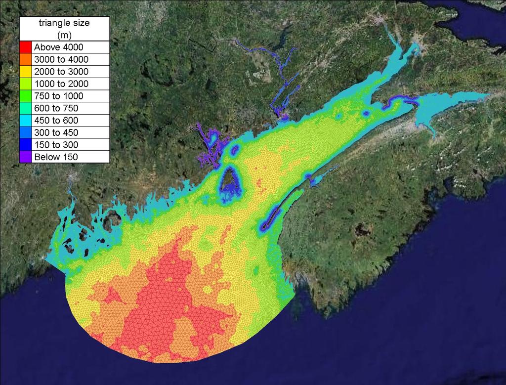
8 Tidal Currents - Bay of Fundy Developed a large 3D hydrodynamic model Irregular finite-element mesh, 1,045,000 triangular elements, 5 levels High-resolution in key areas (~100m elements) Telemac-3D solver Calibrated/verified the model to water levels and current measurements Simulated a typical 14-day spring-neap tide cycle Detailed characterization of the kinetic energy resource at key locations Created MarKE-Fundy - A Marine Kinetic Energy Explorer for the Bay of Fundy
9
10 Model calibration and validation Replicate known water level fluctuations throughout the Bay Compare with available velocity measurements

11 Animation of tidal flows at Minas Passage

12 Minas Passage - Flood
13 Minas Passage - Ebb

14 Minas Passage X-section Ebb Tide Flood Tide

15 Grand Passage, Petit Passage - Flood Petit Passage Long Island Grand Passage


16 Petit Passage - Flood Grand Passage - Flood
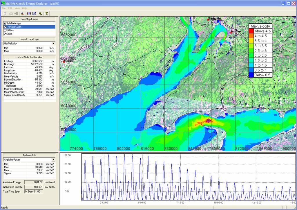
17 Demo of MarKE-Fundy
 Select variable to map (bathymetry, velocity, power density, ) Pan and zoom to region of")
18 Launch the MarKE application Turn on GIS layers (satellite image, communities, roads, utilities, ) Select variable to map (bathymetry, velocity, power density, ) Pan and zoom to region of interest
 Pan and zoom to region of interest GIS layers Variables")
19 Launch the MarKE application Turn on GIS layers (satellite image, communities, roads, utilities, ) Select variable to map (bathymetry, velocity, power density, ) Pan and zoom to region of interest GIS layers Variables to map

20 Select location to explore Select elevation of interest Analyse Location of interest Analyse Elevation

21 View velocity profile


22 View tidal ellipse and velocity rose

23 View time series and histograms of velocity and available power density View statistics Statistics Time series

24 View time series and histograms of velocity and available power density View statistics Statistics Histograms

25 Define turbine properties Size Operating mode (constant speed or variable speed) Cut-off speeds Efficiency curve Analyse Size Operating Mode Cut-off speeds Efficiency Curve

26 View time series and histogram of generated power View statistics View overall efficiency Statistics Available Energy & Generated Energy Generated power time series

27 Save and export data Explore a new location Statistics Available Energy & Generated Energy Generated power histogram
28 With funding from: Natural Resources Canada Province of Nova Scotia Province of New Brunswick Thank you! Andrew Cornett nrc.ca
Whitney Hauslein Global War Wa ming
 Whitney Hauslein Global Warming The Ocean has only recently been used and tested as a new resource to be used as an alternative energy source. This seems awful late in forthcoming since the ocean covers
Appendix 5: Currents in Minas Basin. (Oceans Ltd. 2009)
") Appendix 5: Currents in Minas Basin (Oceans Ltd. 29) Current in Minas Basin May 1, 28 March 29, 29 Submitted To: Minas Basin Pulp and Power P.O. Box 41 53 Prince Street Hansport, NS, BP 1P by 22, Purdy
Appendix 5: Currents in Minas Basin (Oceans Ltd. 29) Current in Minas Basin May 1, 28 March 29, 29 Submitted To: Minas Basin Pulp and Power P.O. Box 41 53 Prince Street Hansport, NS, BP 1P by 22, Purdy
Applications of ELCIRC at LNEC
 stratification in the Guadiana estuary tidal propagation in the Óbidos lagoon Lígia Pinto Anabela Oliveira André B. Fortunato 2 O utline Stratification in the Guadiana estuary The Guadiana estuary Objectives
FEMA Region V. Great Lakes Coastal Flood Study. Pilot Study Webinar. Berrien County, Michigan. February 26, 2014
 FEMA Region V Great Lakes Coastal Flood Study Pilot Study Webinar Berrien County, Michigan February 26, 2014 2 Pilot Study Webinar Agenda Great Lakes Coastal Flood Study Background Demonstration Project
Sensor Platform Project Marine Trials Bidders Conference. Fundy Ocean Research Center for Energy fundyforce.ca
 Sensor Platform Project Marine Trials Bidders Conference Fundy Ocean Research Center for Energy fundyforce.ca 1 Project Team FORCE OceanWorks International Preliminary Design, Operational Procedures Murray
Simulation of hydraulic regime and sediment transport in the Mekong delta coast
 Simulation of hydraulic regime and sediment transport in the Mekong delta coast 1. Introduction Coastal erosion in the Mekong Delta has been recorded in recent years and the erosion rate has been increasing
APPENDIX A Hydrodynamic Model Qualicum Beach Waterfront Master Plan
 Page 1 of 21 CLIENT: Town of Qualicum Beach PROJECT: SIGNATURE DATE CONTRIBUTORS : M. Marti Lopez REVIEWED BY : P. St-Germain, EIT APPROVED BY: J. Readshaw, P.Eng ISSUE/REVISION INDEX Issue Details Code
La Rance tidal power plant in La Rance, France. Tidal and Wave Energy
 La Rance tidal power plant in La Rance, France Tidal and Wave Energy Tides Tides are caused by the pull of the moon. Tides involve the rise and fall of sea levels. Around the coast of Ireland, the sea
Ocean Energy. Haley, Shane, Alston
 Ocean Energy Haley, Shane, Alston What is Ocean Energy? The world s oceans cover nearly 70% of the world's surface The oceans are the world's largest collector of the sun s energy that is continually
Chapter 11 Tides. A tidal bore is formed when a tide arrives to an enclosed river mouth. This is a forced wave that breaks.
 Chapter 11 Tides A tidal bore is formed when a tide arrives to an enclosed river mouth. This is a forced wave that breaks. Tidal range can be very large Tide - rhythmic oscillation of the ocean surface
Figure 4, Photo mosaic taken on February 14 about an hour before sunset near low tide.
 The Impact on Great South Bay of the Breach at Old Inlet Charles N. Flagg and Roger Flood School of Marine and Atmospheric Sciences, Stony Brook University Since the last report was issued on January 31
Tidal streams and tidal stream energy device design
 Tidal streams and tidal stream energy device design This technical article introduces fundamental characteristics of tidal streams and links these to the power production of tidal stream energy devices.
Impact of Dredging the Lower Narrow River on Circulation and Flushing
 Impact of Dredging the Lower Narrow River on Circulation and Flushing Craig Swanson Ph.D. Swanson Environmental Alex Shaw Ocean Engineering, URI Prof. Malcolm L. Spaulding Ocean Engineering, URI 29 January
Lecture Outlines PowerPoint. Chapter 15 Earth Science, 12e Tarbuck/Lutgens
 Lecture Outlines PowerPoint Chapter 15 Earth Science, 12e Tarbuck/Lutgens 2009 Pearson Prentice Hall This work is protected by United States copyright laws and is provided solely for the use of instructors
Tidal Energy from the Severn Estuary: Opportunities and Challenges
 Co-financed with the support of the European Union 1 ERDF Atlantic Area Programme Investing in our common future Tidal Energy from the Severn Estuary: Opportunities and Challenges Prof Roger Falconer,
NUMERICAL AND PHYSICAL MODELING
 POINTE DU BOIS GENERATING STATION SPILLWAY REPLACEMENT PROJECT NUMERICAL AND PHYSICAL MODELING Kara Hurtig, Northwest Hydraulic Consultants, North Vancouver, BC, Canada David S. Brown, KGS Group, Winnipeg,
Request Number IR1-12: Flow Passage. Information Request
 Request Number IR1-12: Flow Passage Information Request Provide additional information about the 100 metre flow passage channel scenario between the Westshore Terminals and the proposed Project terminal
2016 NC Coastal Local Governments Annual Meeting
 2016 NC Coastal Local Governments Annual Meeting Coastal Flood Study Modeling and Mapping 101 April 21, 2016 Tom Langan, PE, CFM Engineering Supervisor NCEM Floodplain Mapping Program FEMA Coastal Flood
Marine Renewables Industry Association. Marine Renewables Industry: Requirements for Oceanographic Measurements, Data Processing and Modelling
 Marine Renewables Industry Association Marine Renewables Industry: Requirements for Oceanographic Measurements, Data Processing and Modelling October 2009 Table of Contents 1. Introduction... 1 2. Measurements
The rate versus time can then be the subject of whatever calculation the user chooses, for example:
 Using Neptune Planner Plus to Export Tidal Rates to Excel These notes are intended to assist the interested user in exporting predicted tidal stream rates into a spreadsheet for the estimation of tidal
Modeling 3D circulation in the Choctawhatchee Bay and River System
 Modeling 3D circulation in the Choctawhatchee Bay and River System Rosemary Cyriac 1, Casey Dietrich 1, Arash Fathi 2, Clint Dawson 2, Kendra Dresback 3, Cheryl Ann Blain 4, Matthew Bilskie 5, Scott Hagen
LITTLE LAGOON & LITTLE LAGOON PASS: RESEARCH UPDATES & DIRECTIONS
 LITTLE LAGOON & LITTLE LAGOON PASS: RESEARCH UPDATES & DIRECTIONS Bret M. Webb, PhD, PE, DCE Professor Department of Civil, Coastal, and Environmental Engineering October 19, 2017 LLPS Meeting Acknowledgments
Dugald Clerk Lecture: Tidal Energy - Challenges and Opportunities
 Monday 2 February 2014 Dugald Clerk Lecture: Tidal Energy - Challenges and Opportunities Marine Energy Resources: Challenges and Opportunities Professor Roger A. Falconer FREng, FICE CH2M HILL Professor
Energy from seas and oceans
 Energy from seas and oceans Marine energy can represent an important source of renewable energy in the near future. In Italy, activities performed in this sector are growing rapidly both in terms of assessment
Modern and Ancient Tides
 Modern and Ancient Tides A lesson plan to be used in conjunction with the Modern and Ancient Tides poster and booklet available from the Indiana Geological Survey. Overview Students will discover how tides
Three-dimensional High-resolution Numerical Study of the Tide and Tidal Current in the Jiaozhou Bay and Olympic Sailing Site
 Three-dimensional High-resolution Numerical Study of the Tide and Tidal Current in the Jiaozhou Bay and Olympic Sailing Site By Jinrui Chen Ocean University of China cooperator: Shiliang Shan, Huaming
Exploring Localized Mixing Dynamics During Wet Weather in a Tidal Fresh Water System
 Exploring Localized Mixing Dynamics During Wet Weather in a Tidal Fresh Water System Ramona McCullough & Phil Duzinski Delaware Estuary Science & Environmental Summit January 27, 2015 Background and objectives
Bay of Fundy Estuary Profile
 s The is a sub-basin of the Bay of Fundy along the northwestern shore of Nova Scotia and at the western end of the Annapolis Valley. The Annapolis River is the major water source flowing into the estuary.
13. TIDES Tidal waters
 Water levels vary in tidal and non-tidal waters: sailors should be aware that the depths shown on the charts do not always represent the actual amount of water under the boat. 13.1 Tidal waters In tidal
INVENTORY OF CANADA S MARINE RENEWABLE ENERGY RESOURCES
 INVENTORY OF CANADA S MARINE RENEWABLE ENERGY RESOURCES A. Cornett CHC-TR-041 April 2006 INVENTORY OF CANADA S MARINE RENEWABLE ENERGY RESOURCES Technical Report CHC-TR-041 April 2006 A. Cornett, Ph.D.,
Renewable and Alternative Energies
 Department of Electrical and Energy Engineering This work is published under a license: Creative Commons BY-NC-SA 4.0 Contents Topic 1. Wind energy. Topic 2. Solar energy.. Topic 4. Hydropower. Topic 5.
LOCAL COASTAL PROGRAM UPDATE
 LOCAL COASTAL PROGRAM UPDATE Agenda Meeting #1 General Information (1 1:45 pm) Introductions and Background Grants involved What is a Local Coastal Program? What is required? LCP Update tasks and schedule
Announcements. Project 2 due Nov 7 th Topics for today: Big waves. Tsunamis, seiches and tidal waves. Tsunamis and seiches
 Announcements Project 2 due Nov 7 th Topics for today: Big waves Tsunamis, seiches and tidal waves Tsunamis and seiches Seiche: standing wave that rocks back and forth within an enclosed or semi-enclosed
Analyzing Human- Environment Interactions using GIS. Cape Breton Highlands Education Centre/Academy
 Analyzing Human- Environment Interactions using GIS Cape Breton Highlands Education Centre/Academy Global Geography 12 The Right Whale Project Why are Right Whales Dying in the Gulf of St. Lawrence?
SLDMB Project NSS NIF. Brian Stone Canadian Coast Guard 2011
 SLDMB Project NSS NIF Brian Stone Canadian Coast Guard 2011 North Atlantic Coast Guard Forum Big challenges relates still to tidal drift and current. To get a reliable result of the maritime search activities,
Earth s oceans covers 71 % _ of the planet s surface. In reality, Earth s ocean waters are all. interconnected as part of a single large global ocean.
 Ocean Motion Met 101: Introduction to the World's Oceans Produced by The COMET Program Geography: Name Pd. Earth s oceans covers 71 % _ of the planet s surface. In reality, Earth s ocean waters are all
Tides. Tides: longest waves. or seas. or ripples
 Tides or ripples or seas Tides: longest waves Tides Definition: The rise and fall of sea level due to the gravitational forces of the Moon and Sun and the rotation of the Earth. Why tides are important?
WAVE FORECASTING FOR OFFSHORE WIND FARMS
 9 th International Workshop on Wave Hindcasting and Forecasting, Victoria, B.C. Canada, September 24-29, 2006 WAVE FORECASTING FOR OFFSHORE WIND FARMS Morten Rugbjerg, Ole René Sørensen and Vagner Jacobsen
CALCASIEU SALINITY STRUCTURES. HYDRODYNAMIC MODELING (To Support Design of Salinity Barriers)
") CALCASIEU SALINITY STRUCTURES HYDRODYNAMIC MODELING (To Support Design of Salinity Barriers) Presentation Overview 1 2 3 4 5 Project Overview and CEA Circulation Modeling Vessel Hydrodynamics Modeling
CALCASIEU SALINITY STRUCTURES HYDRODYNAMIC MODELING (To Support Design of Salinity Barriers) Presentation Overview 1 2 3 4 5 Project Overview and CEA Circulation Modeling Vessel Hydrodynamics Modeling
Hydrodynamic and hydrological modelling to support the operation and design of sea ports
 Hydrodynamic and hydrological modelling to support the operation and design of sea ports Data needs and examples Martijn de Jong (port/nautical requirements, waves, currents) Sofia Caires (mean and extreme
MAR 555 Lecture 20: Coastal Tides
 MAR 555 Lecture 20: Coastal Tides Tides caused by the resulting gravitational and centrifugal forces is called equilibrium tide. They can be expressed using the harmonic functions as N semi! e(semi) =
Monitoring tidal movements in Cook Inlet, Alaska, using the integration of remote sensing data, GIS, and inundation models
 Monitoring tidal movements in Cook Inlet, Alaska, using the integration of remote sensing data, GIS, and inundation models Hua Liu Department of political Science and Geography Old Dominion University
EFFECTS OF WAVE, TIDAL CURRENT AND OCEAN CURRENT COEXISTENCE ON THE WAVE AND CURRENT PREDICTIONS IN THE TSUGARU STRAIT
 EFFECTS OF WAVE, TIDAL CURRENT AND OCEAN CURRENT COEXISTENCE ON THE WAVE AND CURRENT PREDICTIONS IN THE TSUGARU STRAIT Ayumi Saruwatari 1, Yoshihiro Yoneko 2 and Yu Tajima 3 The Tsugaru Strait between
MEASUREMENT OF LONG-TERM AMBIENT NOISE AND TIDAL TURBINE LEVELS IN THE BAY OF FUNDY
 MEASUREMENT OF LONG-TERM AMBIENT NOISE AND TIDAL TURBINE LEVELS IN THE BAY OF FUNDY 11 th European Conference on Underwater Acoustics, 3 July 2012 Bruce Martin 1, Andrew Gerber 2, Christopher Whitt 1,
Modeling Sediment Transport Along the Upper Texas Coast
 Modeling Sediment Transport Along the Upper Texas Coast David B. King Jr. Jeffery P. Waters William R. Curtis Highway 87 roadbed, Jefferson County Galveston District Corps Sabine Pass to San Luis Pass
An Atlas of Oceanic Internal Solitary Waves (May 2002) by Global Ocean Associates Prepared for the Office of Naval Research - Code 322PO
 by Global Ocean Associates Prepared for the Office of Naval Research - Code 322PO") Overview is located in the western Pacific Ocean along the west side of the Philippines (between approximately 5 o and 11 o N. latitude and 117 o and 123 o E. longitude). It is a deepwater sea, roughly
Overview is located in the western Pacific Ocean along the west side of the Philippines (between approximately 5 o and 11 o N. latitude and 117 o and 123 o E. longitude). It is a deepwater sea, roughly
Impact of the tides, wind and shelf circulation on the Gironde river plume dynamics
 Impact of the tides, wind and shelf circulation on the Gironde river plume dynamics F. Toublanc 1, N. Ayoub 2, P. Marsaleix 3, P. De Mey 2 1 CNES/LEGOS 2 CNRS/LEGOS 3 CNRS/LA, Toulouse, France 5th GODAE
Wave Energy Atlas in Vietnam
 Wave Energy Atlas in Vietnam Nguyen Manh Hung, Duong Cong Dien 1 1 Institute of Mechanics, 264 Doi Can Str. Hanoi, Vietnam nmhungim@gmail.com; duongdienim@gmail.com Abstract Vietnam has achieved remarkable
Geology 15 Activity 5 A Tsunami
 Materials: Marigram recorded in San Diego, May 23, 1960. Travel Time Graph To San Diego. Answer sheet Source of information: Lander, James F., Patricia A. Lockridge and Michael J. Kozuch, s Affecting the
Baird. Innovation, Excellence & Service Oceans, Lakes & Rivers
 Profile Capabilities Innovation, Excellence & Service Oceans, Lakes & Rivers Baird provides professional engineering and technical services related to the design of coastal structures and facilities that
OCEANOGRAPHY STUDY GUIDE
 OCEANOGRAPHY STUDY GUIDE Chapter 2 Section 1 1. Most abundant salt in ocean. Sodium chloride; NaCl 2. Amount of Earth covered by Water 71% 3. Four oceans: What are they? Atlantic, Pacific, Arctic, Indian
Scholarship 2018 Earth and Space Science
 S 93104R Scholarship 2018 Earth and Space Science 9.30 a.m. Wednesday 7 November 2018 RESOURCE BOOKLET Refer to this booklet to answer the questions for Scholarship Earth and Space Science 93104. Check
Characterizing Ireland s wave energy resource
 Snapshots of Doctoral Research at University College Cork 2011 Characterizing Ireland s wave energy resource Brendan Cahill Hydraulics & Maritime Research Centre, UCC Introduction In theory, the energy
InVEST model demo: Renewable Energy (Wave Energy) Gregg Verutes
 Gregg Verutes") InVEST model demo: Renewable Energy (Wave Energy) Gregg Verutes Some WEC Devices Attenuator Point Absorber Oscillating Water Column Overtopping Device Oscillating Wave Surge Converter Submerged Pressure
InVEST model demo: Renewable Energy (Wave Energy) Gregg Verutes Some WEC Devices Attenuator Point Absorber Oscillating Water Column Overtopping Device Oscillating Wave Surge Converter Submerged Pressure
On the use of a high resolution wind forcing in the operational coastal wave model WW3
 On the use of a high resolution wind forcing in the operational coastal wave model WW3 A. Dalphinet (1), L. Aouf (1), C. Bataille (1), H. Michaud (2) (1) Météo-France (2) SHOM Île de Sein (Brittany) 05/02/2014
THE WAVE CLIMATE IN THE BELGIAN COASTAL ZONE
 THE WAVE CLIMATE IN THE BELGIAN COASTAL ZONE Toon Verwaest, Flanders Hydraulics Research, toon.verwaest@mow.vlaanderen.be Sarah Doorme, IMDC, sarah.doorme@imdc.be Kristof Verelst, Flanders Hydraulics Research,
OCN 201 Tides. Tsunamis, Tides and other long waves
 OCN 201 Tides Tsunamis, Tides and other long waves Storm surges Caused by winds and low atmospheric pressure associated with large storms Can raise sea surface by up to 25 ft, bottom contours magnify effect
WAVES ENERGY NEAR THE BAR OF RIO GRANDE'S HARBOR ENTRANCE
 ember 6-11, 2005, Ouro Preto, MG WAVES ENERGY NEAR THE BAR OF RIO GRANDE'S HARBOR ENTRANCE Gustavo Geraldes Pappen Fundação Universidade Federal do Rio Grande Av. Itália, km 8 Rio Grande RS gpappen@hotmail.com
Evaluation of June 9, 2014 Federal Emergency Management Agency Flood Insurance Study for Town of Weymouth, Norfolk, Co, MA
 Evaluation of June 9, 2014 Federal Emergency Management Agency Flood Insurance Study for Town of Weymouth, Norfolk, Co, MA Prepared For: Woodard & Curran 95 Cedar Street, Suite 100 Providence, RI 02903
Hydrologic Feasibility of Storm Surge Barriers
 Hydrologic Feasibility of Storm Surge Barriers Malcolm J. Bowman, School of Marine and Atmospheric Sciences State University of New York, Stony Brook, NY. Presented at Against the Deluge: Storm Surge Barriers
Geology 10 Activity 8 A Tsunami
 Geology 10 Activity 8 A Materials: Marigram recorded in San Diego, May 23, 1960. Travel Time Graph To San Diego. Answer sheet Source of information: Lander, James F., Patricia A. Lockridge and Michael
Tidally influenced environments. By Alex Tkaczyk, Henrique Menezes, and Isaac Foli
 Tidally influenced environments By Alex Tkaczyk, Henrique Menezes, and Isaac Foli Goals and aims Describe the role of tidal influence in depositional environments. - Deltas - Estuaries Provide an overview
PARK - Main Result Calculation: PARK calculation (5 x 166m, + LT CORR + MITIGATION) N.O. Jensen (RISØ/EMD)
 N.O. Jensen (RISØ/EMD)") PRK - Main Result Calculation: PRK calculation (5 x V15 @ 166m, + LT CORR + MITIGTION) Wake Model N.O. Jensen (RISØ/EMD) Calculation Settings ir density calculation mode Result for WTG at hub altitude
PRK - Main Result Calculation: PRK calculation (5 x V15 @ 166m, + LT CORR + MITIGTION) Wake Model N.O. Jensen (RISØ/EMD) Calculation Settings ir density calculation mode Result for WTG at hub altitude
: Hydrodynamic input for 2D Vessel Simulations (HY- 0027)
") Technical Note To : Christian Taylor (PoHDA) From : Rohan Hudson Cc : Ben Gray Date : 1/04/2015 (Final Draft) Subject : Hydrodynamic input for 2D Vessel Simulations (HY- 0027) Introduction This Technical
Technical Note To : Christian Taylor (PoHDA) From : Rohan Hudson Cc : Ben Gray Date : 1/04/2015 (Final Draft) Subject : Hydrodynamic input for 2D Vessel Simulations (HY- 0027) Introduction This Technical
The transition to sustainable energy
 ATSE Symposium The transition to sustainable energy Peter Littlewood 8 Nov 2016 The changing world economy Index 180 170 160 150 140 130 120 110 100 90 Economies less energy intensive Electricity less
Background. that may differ from the rest of the world.
 Background ¾Climate Change impacts in the Pacific very serious and will impact the lives and livelihoods of the people people. ¾Sea level rise is a major threat need to help reduce carbon emission. One
Tidal flushing and eddy shedding in Mount Hope Bay and Narragansett Bay: An application of FVCOM
 Click Here for Full Article JOURNAL OF GEOPHYSICAL RESEARCH, VOL. 111,, doi:10.1029/2005jc003135, 2006 Tidal flushing and eddy shedding in Mount Hope Bay and Narragansett Bay: An application of FVCOM Liuzhi
International and Niche Markets for Wave and Tidal Energy. Neil Ferguson
 International and Niche Markets for Wave and Tidal Energy Neil Ferguson Scottish Enterprise Scottish Enterprise aims to deliver a significant, lasting effect on the Scottish economy. Our four interconnected
WindPRO version Nov 2012 Project:
 23/11/2012 15:21 / 1 WAsP interface - Main Result Calculation: WAsP Interface example Name for WAsP Site coordinates UTM NAD27 Zone: 14 East: 451,101 North: 5,110,347 Air density calculation mode Result
ESB Ocean Energy Projects
 MRIA, February 2013 ESB Ocean Energy Projects Opportunities in an All-Islands Market John Fitzgerald ESB Ocean Energy Developing new lines of business for ESB and Ireland 200M Cleantech Fund Home Energy
Wave and meteorological site characterization for the Wave Energy Research Centre in Lord s Cove, Newfoundland and Labrador, Canada
 Wave and meteorological site characterization for the Wave Energy Research Centre in Lord s Cove, Newfoundland and Labrador, Canada Michael Graham College of the North Atlantic Burin, NL mike.graham@cna.nl.ca
Recent developments in wave energy along the coast of southern Africa
 Recent developments in wave energy along the coast of southern Africa J. R. Joubert 1 and J. L. van Niekerk 2 1 Centre for Renewable Energy Studies, Mechanical & Mechatronic Engineering Department, Stellenbosch
San Diego Coastal Ocean Observing System
 California Clean Beaches Initiative San Diego Coastal Ocean Observing System WWW.SDCOOS.ORG Presentation to Imperial Beach City Council August 3, 2005 Eric J. Terrill, Ph.D. Scripps Institution of Oceanography
Management of American Eel Fisheries in Canada. Laura Hussey-Bondt Senior Advisor, Resource Management Fisheries and Oceans Canada Maritimes Region
 Management of American Eel Fisheries in Canada Laura Hussey-Bondt Senior Advisor, Resource Management Fisheries and Oceans Canada Maritimes Region DFO Regions 2 Overview: Management of American Eel Fisheries
FOR INFORMATION ONLY. Gold Coast Seaway Channel Scour and Rock Wall Stability Investigation. R.B doc December 2011
 A part of BMT in Energy and Environment Gold Coast Seaway Channel Scour and Rock Wall Stability Investigation R.B18625.001.00.doc December 2011 Gold Coast Seaway Channel Scour and Rock Wall Stability Investigation
NRC Publications Archive Archives des publications du CNRC
 NRC Publications Archive Archives des publications du CNRC Documenting Ice in the Bay of Fundy Canada Sanders, R.; Baddour, R. E. For the publisher s version, please access the DOI link below./ Pour consulter
Offshore Wind Energy Stringent quality assurance and quality control. Coastal and Freshwater Fast responding and flexible organisation
 Services Oceanographic and Positioning Equipment Rental Meteorological and Oceanographic Surveys Data Analysis and Characterisation Marine Energy Resource Assessment Real-Time Monitoring Founded in 2010,
REFINEMENTS TO THE EFDC MODEL FOR PREDICTING THE HYDRO- ENVIRONMENTAL IMPACTS OF A BARRAGE ACROSS THE SEVERN ESTUARY
 REFINEMENTS TO THE EFDC MODEL FOR PREDICTING THE HYDRO- ENVIRONMENTAL IMPACTS OF A BARRAGE ACROSS THE SEVERN ESTUARY 1 1 1 1 1 1 0 1 0 JUNTAO ZHOU (1), ROGER A. FALCONER (1), BINLIANG LIN (1, ) (1): Hydro-environmental
FINAL REPORT APPENDIX A. Physical Description of the Shubenacadie River
 FINAL REPORT APPENDIX A Physical Description of the Shubenacadie River Smart Solutions for Engineering, Science and Computing Physical Description of the Shubenacadie River Martec Technical Report # TR-07-12
Alstom Ocean Energy Path towards Industrailsation. Ken Street 18 th April 2013
 Alstom Ocean Energy Path towards Industrailsation Ken Street 18 th April 2013 Three main activities in four Sectors Equipment & services for power generation Equipment & services for rail transport ALSTOM
Structure and discharge test cases
 Chapter 28 Structure and discharge test cases 28.1 Introduction Three test case have been implemented to test the performance and applicability of the structures and discharges modules. drythin Simulates
Feasibility Study for Dredging of Khaprabhanga Chapalir Don River in Patuakhali District for Improvement of Navigability
 IOSR Journal of Engineering (IOSRJEN) ISSN (e): 2250-3021, ISSN (p): 2278-8719 Vol. 04, Issue 06 (June. 2014), V3 PP 32-38 www.iosrjen.org Feasibility Study for Dredging of Khaprabhanga Chapalir Don River
Tidal Energy. Definition of Tidal Energy. Tidal energy is energy derived from the movement of the ocean tides.
 Tidal Energy Definition of Tidal Energy Tidal energy is energy derived from the movement of the ocean tides. Water has mass. When it moves, it has kinetic energy which can be harnessed. Kinetic energy
SWIFT. The Stratospheric Wind Interferometer for Transport Studies
 The Stratospheric Wind Interferometer for Transport Studies SWIFT I. McDade, C. Haley, J. Drummond, K. Strong, B. Solheim, T. Shepherd, Y. Rochon, and the SWIFT Team ESA What is SWIFT? SWIFT is the Stratospheric
APPENDIX G WEATHER DATA SELECTED EXTRACTS FROM ENVIRONMENTAL DATA FOR BCFS VESSEL REPLACEMENT PROGRAM DRAFT REPORT
 APPENDIX G WEATHER DATA SELECTED EXTRACTS FROM ENVIRONMENTAL DATA FOR BCFS VESSEL REPLACEMENT PROGRAM DRAFT REPORT Prepared for: B.C. Ferries Services Inc. Prepared by: George Roddan, P.Eng. Roddan Engineering
SURFACE CURRENTS AND TIDES
 NAME SURFACE CURRENTS AND TIDES I. Origin of surface currents Surface currents arise due to the interaction of the prevailing wis a the ocean surface. Hence the surface wi pattern (Figure 1) plays a key
HARBOUR SEDIMENTATION - COMPARISON WITH MODEL
 HARBOUR SEDIMENTATION - COMPARISON WITH MODEL ABSTRACT A mobile-bed model study of Pointe Sapin Harbour, in the Gulf of St. Lawrence, resulted in construction of a detached breakwater and sand trap to
Morphodynamic Modelling of a Shoreface Nourishment at Egmond-aan-Zee, The Netherlands
 Morphodynamic Modelling of a Shoreface Nourishment at Egmond-aan-Zee, The Netherlands Christophe BRIERE 1, Maarten van ORMONDT 1, Dirk-Jan WALSTRA 1,2 1 Deltares WL Delft Hydraulics, PO Box 177, 2600 MH
The Various Components of the Circulation in the Singapore Strait Region: Tidal, Wind and Eddy-driven Circulations and Their Relative Importance
 The Various Components of the Circulation in the Singapore Strait Region: Tidal, Wind and Eddy-driven Circulations and Their Relative Importance Haoliang Chen CENSAM, Singapore-MIT Alliance for Research
MIKE 21 Toolbox. Global Tide Model Tidal prediction
 MIKE 21 Toolbox Global Tide Model Tidal prediction MIKE Powered by DHI 2017 DHI headquarters Agern Allé 5 DK-2970 Hørsholm Denmark +45 4516 9200 Telephone +45 4516 9333 Support +45 4516 9292 Telefax mike@dhigroup.com
U.S. Army Engineer Institute for Water Resources
 Sea Level Change Curve Calculator (2014.88) (DRAFT) U.S. Army Engineer Institute for Water Resources Table of Contents 1. INTRODUCTION... 2 1.1 BACKGROUND... 2 1.1.1 INFORMATION QUALITY ACT... 2 1.2 OVERVIEW...
Taranaki Tsunami Inundation Analysis. Prepared for Taranaki Civil Defence Emergency Management Group. Final Version
 Taranaki Tsunami Inundation Analysis Prepared for Taranaki Civil Defence Emergency Management Group Final Version June 2012 AM 12/07 HBRC Plan Number 4362 Asset Management Group Technical Report Prepared
NUMERICAL INVESTIGATION ON WATER DISCHARGE CAPABILITY OF SLUICE CAISSON OF TIDAL POWER PLANT
 Proceedings of the Sixth International Conference on Asian and Pacific Coasts (APAC ) December 4 6,, Hong Kong, China NUMERICAL INVESTIGATION ON WATER DISCHARGE CAPABILITY OF SLUICE CAISSON OF TIDAL POWER
BILLY BISHOP TORONTO CITY AIRPORT PRELIMINARY RUNWAY DESIGN COASTAL ENGINEERING STUDY
 Bâtiment Infrastructures municipales Transport Industriel Énergie Environnement BILLY BISHOP TORONTO CITY AIRPORT PRELIMINARY RUNWAY DESIGN COASTAL ENGINEERING STUDY N. Guillemette 1, C. Glodowski 1, P.
Sustainable Energy Science and Engineering Center. Ocean Energy. Reference: Renewable Energy by Godfrey Boyle, Oxford University Press, 2004.
 Ocean Energy Reference: Renewable Energy by Godfrey Boyle, Oxford University Press, 2004. Ocean Energy Oceans cover most of the (70%) of the earth s surface and they generate thermal energy from the sun
Wind and Tidal - Benefits and Opportunities in Australia
 Wind and Tidal - Benefits and Opportunities in Australia Presented by MR MATTHEW KEYS, BEng (Civil) Lead Analysis Engineer Carnegie Corporation Ltd 2007 Carnegie Corporation Ltd Outline Ocean Energy Introduction
APPENDIX H PLUME MODELS
 APPENDIX H PLUME MODELS APPENDIX H PLUME MODELS Prior to the initiation of recovery activities, the National Oceanic and Atmospheric Administration ran a series of oil plume trajectory analyses (2001a)
Project Incorporation of Sea Level Rise City of Newport Beach Approach for Balboa Islands, City of Newport Beach, California
 Project Incorporation of Sea Level Rise City of Newport Beach Approach for Balboa Islands, City of Newport Beach, California Ying Poon, Everest International Consultants, Inc. CMANC Annual Winter Meeting
Long term observations of internal waves with shore based video cameras. Ata Suanda and John A. Barth
 Long term observations of internal waves with shore based video cameras Ata Suanda and John A. Barth Internal wave? What is an internal wave? Interior oscillations What is an internal wave? Interior oscillations
Avaavaroa passage. Rarotonga nearshore wave hindcast 21 09' 21 12' 21 15' 21 18' ' ' ' '
 Avaavaroa passage Rarotonga nearshore wave hindcast 21 09' 21 ' Fuel Pipeline Avatiu Passage Black Rock Avarua Passage Pue Tupapa Papua Passage Avaavaroa Passage 21 15' Ngatangiia Passage onga Wave Hotspot