SHOALHAVEN DREDGING PROJECT REVIEW OF ENVIRONMENTAL FACTORS
|
|
|
- Anne Lee
- 5 years ago
- Views:
Transcription

1 SHOALHAVEN DREDGING PROJECT REVIEW OF ENVIRONMENTAL FACTORS Prepared for Shoalhaven City Council 20 March 2015 Project Number 8A0472

2 HASKONING AUSTRALIA PTY LIMITED Level Berry Street NORTH SYDNEY NSW Document title Shoalhaven Dredging Project Review of Environmental Factors Document short title Shoalhaven Dredging REF Status Preliminary Final Draft Date 20 March 2015 Project number 8A0472 Client Shoalhaven City Council Reference 8A0472_BSM_Shoalhaven Dredging REF Final Draft Drafted by Checked by Ben Morgan Gary Blumberg Date/initials check 20/03/15 Approved by Gary Blumberg Date/initials approval 20/03/15
3 CONTENTS Page 1 INTRODUCTION Background Review of Environmental Factors Scope 1 2 PROPOSED WORKS Project Description Methodology Currambene Creek Navigation Channel Sussex Inlet Navigation Channel Sussex Inlet Canals (Rivera Keys Estate) Lake Conjola Configuration Dredging Mollymook Beach Creek and Dune Protection Works Sale of Sand Program and Sequencing 25 3 STATUTORY REQUIREMENTS Approvals Framework Other Approvals 27 4 CONSULTATION Public Authority Consultation Issues Raised Consultation with Community 30 5 EXISTING ENVIRONMENT Tenure, Land Use and Zoning Shoreline Morphology and Bathymetry Coastal Processes Wind Climate Rainfall Waves Tidal Planes Extreme Water Levels Sea Level Rise Due to Climate Change Currents Sediment Transport Water Quality Sediment and Rock Characteristics Sediment Sampling and Analysis Physical Sediment Properties Contaminants Acid Sulfate Soils Rock Sampling and Analysis Rock Properties Ecology Aboriginal Cultural Heritage Traffic 76 Shoalhaven Dredging REF - i -
4 5.9 Recreational Use Commercial Fishing/Aquaculture 78 6 ENVIRONMENTAL IMPACT ASSESSMENT AND MITIGATION MEASURES Hydrodynamics, Hydraulics and Sediment Transport General Monitoring of Dredge Areas Monitoring of Nourishment Areas Sediment and Water Quality Dredging Works Placement of Dredged Sand Ecology Ecological Constraints and Potential Impacts Impact Mitigation Aboriginal Cultural Heritage Traffic Odour Noise Visual Impact Access and Recreational Use Sale of Sand Cumulative Impacts with Huskisson Wharf Upgrade ENVIRONMENTAL FACTORS CONSIDERED PROJECT JUSTIFICATION AND ALTERNATIVES CONSIDERED General Benefits of Proposed Works Alternatives Considered Ecologically Sustainable Development General Application to the Project Proposal CONCLUSION REFERENCES 115 Tables Table 1: Overview of Dredging and Nourishment Projects 4 Table 2: Summary of Land Tenure and Zoning 33 Table 3: AS Hour Design Wind Speed 37 Table 4: Analysis of Offshore Wave Data in NSW (Shand et al) 38 Table 5: Wind-wave hindcasting results using methods from USACE (2002) 38 Table 6: Mollymook Beach Wave Climate 40 Table 7: Tidal Planes (m AHD) 41 Table 8: Extreme Water Levels 43 Table 9: Sussex Inlet Entrance Tidal Currents and Tidal Flow 45 Table 10: Flood Level, Flood Flow and Current in Sussex Inlet (Webb, McKeown and Associates, 2001) 45 Shoalhaven Dredging REF - ii -
5 Table 11: Flood Level, Flood Flow and Current in the Canals (Webb, McKeown and Associates, 2001) 46 Table 12: Water Quality Testing Results 49 Table 13: Overview of available sediment and rock information 53 Table 14: Sediment sample physical properties 55 Table 15: Sediment Sampling Geochemical Results 59 Table 16: Acid Sulfate Soils Field Screening Tests Results 62 Table 17: Acid Sulfate Soils Chromium Reducible Sulfur Test Results 63 Table 18: Depth of refusal of jet probes 64 Table 19: Unconfined compressive strength of rock cores 65 Table 20 Summary of Sediment and Water Quality Control Measures 84 Table 21 Acceptable noise levels (EPA, 2000) and distance from noise source 99 Table 22: Benefits of Proposed Works 108 Plates Plate 1 View from the Bay into Currambene Creek 13 Plate 2 Currambene Creek entrance 13 Plate 3 Temporary stockpile area in Currambene Creek behind training wall 14 Plate 4 Callala Beach nourishment area 14 Plate 5 Crest of training wall 14 Plate 6 Crest of Training Wall 14 Plate 7 View along Callala Beach nourishment area 14 Plate 8 View of Callala Beach nourishment area from the Bay 14 Plate 9 View of flood tide delta in Sussex Inlet 16 Plate 10 Reserve behind Bowling Club 16 Plate 11 Eroded foreshore in front of The Haven 16 Plate 12 Eroded foreshore at Alamein Caravan Park 16 Plate 13 Beaches requiring nourishment 18 Plate 14 Failing seawall on bend 18 Plate 15 Note vegetation in front of wall providing erosion control 18 Plate 16 Root ball provding bank support 19 Plate 17 Potential sand souce in canals at storwmater outlets 19 Plate 18 View to Lake Conjola from Cunjurong 20 Plate 19 Potential temporary storage area to trucking off site 20 Plate 20 Looking upstream to bridge 24 Plate 21 Looking downstream from bridge 24 Plate 22 Looking south along creek entrance 24 Plate 23 Looking upstream on north side of creek bank 24 Figures Figure 1 Dredging Projects Location Plan 2 Figure 2 Currambene Creek Navigation Channel General Arrangement 6 Figure 3 Currambene Creek Navigation Channel Dredge Footprint 7 Figure 4 Sussex Inlet Navigation Channel General Arrangement 8 Figure 5 Lake Conjola Configuration Dredging General Arrangement 9 Figure 6 Mollymook Beach Creek and Dune Protection General Arrangement 10 Figure 7 Sussex Inlet Canals General Arrangement 11 Figure 8 Callala Beach nourishment profile 15 Shoalhaven Dredging REF - iii -
6 Figure 9 Typical section of flow retard/groyne 17 Figure 10 Original construction profile at Rivera Keys (PWD, 1989) 18 Figure 11 Regime state overlay based on Patterson Britton & Partners (PBP,1999) conceptual understanding of estuary morphodyhamic processes overlaid on a recent (Nov 2013) aerial photograph 20 Figure 12 Mollymook Beach priority nourishment area 21 Figure 13 Mollymook Beach nourishment profile 21 Figure 14 Typical Sections for Mollymook Beach Creek and Dune Protection 23 Figure 15 Lake Conjola Water Quality and Sediment Quality sampling locations 50 Figure 16 Currambene Creek Water Quality and Sediment Quality sampling locations 50 Figure 17 Callala Beach Water Quality and Sediment Quality sampling locations 51 Figure 18 Sussex Inlet Water Quality and Sediment Quality sampling locations 51 Figure 19 Mollymook Beach Water Quality and Sediment Quality sampling locations 52 Figure 20 Currambene Creek Acid Sulfate Risk Map (Department of Land and Water Conservation) 60 Figure 21 Sussex Inlet Acid Sulfate Risk Map (Department of Land and Water Conservation) 60 Figure 22 Sussex Inlet (Canals) Acid Sulfate Risk Map (Department of Land and Water Conservation) 61 Figure 23 Lake Conjola Acid Sulfate Risk Map (Department of Land and Water Conservation) 62 Figure 24 Myola Spit, Currambene Creek 66 Figure 25 Sand stockpiling area behind training wall in Currambene Creek 67 Figure 26 Dredge Area 1 in Sussex Inlet Navigation Channel 68 Figure 27 Dredge Area 2, 3 and 4 in Sussex Inlet Navigation Channel 69 Figure 28 Temporary Storage Area on eastern side of channel 70 Figure 29 Seagrass near The Big Dipper on the western side of Sussex Inlet Navigation Channel 71 Figure 30 Northern Stockpiling Area at Lake Conjola 73 Figure 31 Blackwater Creek and Mollymook Beach 74 Figure 32 Currambene Creek acceptable dredging times and locations 98 Appendicies APPENDIX A Sussex Inlet Foreshore Nourishment Additional Information APPENDIX B Consultation Correspondence APPENDIX C Tabulated Public Authority Responses APPENDIX D Sediment Analysis APPENDIX E Currambene Creek Rock Investigations APPENDIX F Aboriginal Cultural Heritage APPENDIX G Marine Ecology Shoalhaven Dredging REF - iv -
7 1 INTRODUCTION 1.1 Background Shoalhaven City Council (SCC) developed a strategy to deal with increased demand from the community for improving navigation and boating safety at a number of estuarine locations within the Shoalhaven Local Government area. This strategy was documented in the Shoalhaven City Wide Dredging Feasibility Study that was prepared in consultation with nominated community members of Council s Natural Resources and Floodplain Management Committees. The dredging priorities of the Citywide Dredging Feasibility Study were adopted by Council in April The Currambene Creek, Sussex Inlet Navigation Channel, and Lake Conjola projects have each received funding from the NSW State Government through the Rescue our Waterways Program. SCC adopted the Canal Estate Management Plan in December 2014 that sets out Council and resident/ratepayer responsibilities in relation to management of canal estates. Funding for any works in the canal estates is yet to be finalised. SCC has completed a Draft Coastal Zone Management Plan (CZMP) for the Shoalhaven Local Government Area. A suite of strategies and actions were identified for Callala and Mollymook Beaches. These beaches are noted as particularly high risk beaches in the Shoalhaven and which are now recognised by the NSW Office of Environment and Heritage (OEH) as meeting the criteria for inclusion as Authorised Locations as per the Code of Practice under the Coastal Protection Act Seawall protection and nourishment are identified as the principal options available to remediate against beach erosion. Council would look to use dredged sand from the State Government funded dredging projects as nourishment for Callala Beach and Mollymook Beach. Creek entrance training works along the north side of Blackwater Creek to protect the exposed southern end of the nourishment at Mollymook Beach and deliver other coastal hazard protection benefits outlined in the Shoalhaven Authorised Locations Coastal Erosion Remediation Options report for Mollymook Beach (RHDHV, 2012) also form part of the overall strategy. 1.2 Review of Environmental Factors Scope In view of the Shoalhaven City Wide Dredging Feasibility Study, Canal Estate Management Plan, Draft CZMP, and Authorised Locations investigation for Mollymook Beach, this REF covers the following projects: Currambene Creek Navigation Channel (including beach nourishment at Callala Beach); Sussex Inlet Navigation Channel; Sussex Inlet Canals (Rivera Keys Estate); Lake Conjola Configuration Dredging; and Mollymook Beach Dune Protection (Blackwater Creek). This REF has been prepared specifically for the above mentioned projects to be conducted as a once off activity. Future maintenance dredging would require a revised or new REF to be prepared. Shoalhaven Dredging REF - 1 -

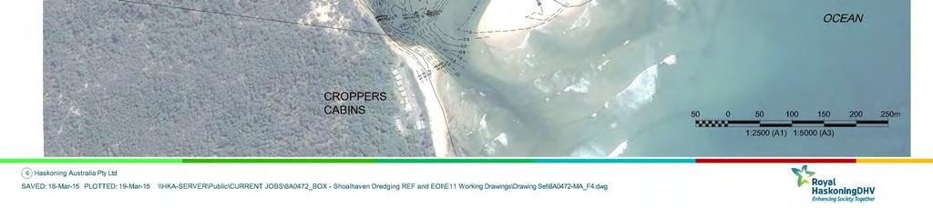
8 2 PROPOSED WORKS 2.1 Project Description Shoalhaven City Council is proposing the four following dredging projects and a creek/dune protection project within the Shoalhaven: Currambene Creek Navigation Channel (including beach nourishment at Callala Beach); Sussex Inlet Navigation Channel; Sussex Inlet Canals (Rivera Keys Estate); Lake Conjola Configuration Dredging; and Mollymook Beach Dune Protection (Blackwater Creek). The locations of these projects are shown on Figure 1. Figure 1 Dredging Projects Location Plan Shoalhaven Dredging REF - 2 -
9 An overview of each of the four dredging projects are provided in Table 1 and general arrangement plans from Figure 2 to Figure 5, and Figure 7. The aim of the Mollymook Beach Creek and Dune Protection is to protect the northern bank of Blackwater Creek and the southern portion of the proposed nourishment area (sourced from the Lake Conjola Dredging) from creek break out, coastal erosion and inundation. The protected area is occupied by residential properties and Council s assets including sewer pump station and road. The works include a rock revetment that transitions into a geotextile container structure. Both structures are approximately 60m in length (120m maximum in total) and buried within the dune system only to be exposed in extreme storm events. A general arrangement of the works is shown on Figure 6. The Dune Protection Structure works are expected to take around eight weeks. Shoalhaven City Council is also planning on upgrading the Huskisson Wharves that involves: Linking of eastern and western wharves; Installation of piling; Installation of a pontoon; and Dredging immediately in front of the berthing line using a land based excavator. The wharf upgrade works are scheduled to occur during 2015 and would be constructed from shore. These works are captured in a separate REF document currently being prepared by TLB Engineers. Shoalhaven Dredging REF - 3 -
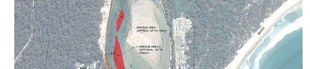
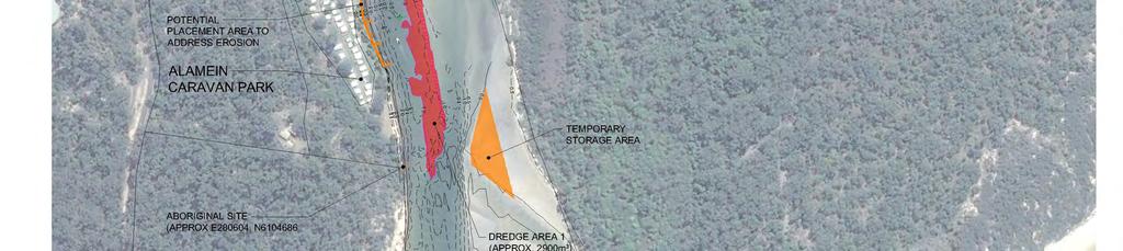
10 Table 1: Overview of Dredging and Nourishment Projects Details Aim Users Dredge Area and Depth Dredge Quantity Estimate Currambene Creek Navigation Channel Navigation improvements to Currambene Creek entrance and access wharves. Recreational yachts/power boats, tour operators, whale / dolphin watching, game fishing boats, potential for cruise ship tenders. Entrance to Currambene Creek to -2.5m AHD (~1.65m below ISLW), and 20m wide. Does NOT consider dredging to increase the swing mooring area. Up to 4,000m 3, of which 200m 3 is rock. Sussex Inlet Navigation Channel Improve safety and navigation in the channel, particularly for marine rescue. Marine rescue vessel, recreational power boats and kayakers. Shallower areas of Sussex Inlet channel generally between Alamein Caravan Park and The Haven to -2.0m AHD (1.7m below ISLW). Three dredging areas proposed, namely Areas 1, 2 and 3 (Option 3 optional to assist with maintaining channel, relieving erosive stress on the southern shorelines, and contributing to sand nourishment works). Project Sussex Inlet Canals (Rivera Keys Estate) Replenish eroded beaches in front of seawalls to cover exposed asbestos sheetpiles, to restore gross stability at the walls (positive support), improve recreational amenity, and improve navigation depths locally at private jetty structures and stormwater outlets as required. Predominately local power and nonpowered boat owners within canal system. Sussex Inlet Canals to -0.4m AHD in accordance with PWD Canal Subdivision Guidelines, unlikely dredging for navigation along the canals is required. Dredging may be required to clear local deposits (in front of jetties and stormwater outlets), covered below. Lake Conjola Configuration Dredging Improve navigation to reconnect boat ramp at Cunjurong Point to main body of the lake, better separation of boat users from swimmers, facilitate future entrance openings. Swimmers, recreational power boats, kayakers. Up to 8,000m 3. Up to 2,000m 3 Up to 12,000m 3. Lower estuary: dredge footprint to enhance present regime state. Expected depth between 0.5 to 2m below existing. Dredging most likely to link the boat ramp to the main channel through the general flood tide channel route and is subject to community consultation. Shoalhaven Dredging REF - 4 -
11 Details Dredge Material Placement Area Timing Currambene Creek Navigation Channel Clean sand and rock. A limited bedrock outcrop extends into the channel near the outer end of Voyager Park. Sand to be used as nourishment with dune revegetation at Callala Beach. Sand to be initially pumped to and dewatered at temporary storage area behind the Myola training wall 900m upstream of Creek entrance, and then progressively truck the sand to Callala Beach. Actual dredging expected to take 3 weeks plus mobilisation/demobilisation plus time for nourishment works. Sussex Inlet Navigation Channel Clean sand Option for sand placed locally on northern edge of the flood tide delta (temporary storage area) to be dewatered and transported to: the western foreshore of the lower inlet to address erosion; in canals to address erosion; on reserve in front of bowling club for reuse/sale. Sand can also be directly pumped to the western foreshore to address erosion. Actual dredging expected to take up to 6 weeks plus mobilisation/demobilisation and nourishment (for erosion) works. Project Sussex Inlet Canals (Rivera Keys Estate) Estuarine sand/sediment, storm water outlet sediment Sand to be placed in front of walls as required. Potential sand sources include clean sand from inside the canals, and/or imported from the navigation channel dredging. If required suitable clean sand may be imported from other sources. Expect 4 to 8 weeks to complete. Lake Conjola Configuration Dredging Clean sand. To pump at least half of the sand directly to nourish eroded spit and dune on the south side of the entrance. Up to half of the sand would be pumped to a temporary storage area and removed from site for nourishment of Mollymook Beach, and potentially sold. Temporary storage area options are the southern dune area, or along the Cunjurong foreshore. Actual dredging expected to take up to 6 weeks plus mobilisation/demobilisation plus time for nourishment works Figure No. Figure 2, Figure 3 Figure 4 Figure 5 Figure 7 Shoalhaven Dredging REF - 5 -
12
13


14
15 FIGURE 5 LAKE CONJOLA CONFIGURATION DREDGING GENERAL ARRANGEMENT POTENTIAL TEMPORARY STORAGE AREA PRIOR TO TRUCKING OFFSITE. REINSTATE ACCESS ROAD TO TEMPORARY STORAGE AREA CUNJURONG ABORIGINAL SITE UNABLE TO BE FOUND POINT FLOOD CHANNEL ROUTE OPTIONS. ACTUAL DREDGING FOOTPRINT DEPENDENT ON CURRENT CHANNEL FORMATION. BOTH CHANNELS NOT LIKELY TO BE DREDGED CUNJURONG BOAT RAMP AND CARPARK TO BE USED AS SITE COMPOUND IF TEMPORARY STORAGE AREA ON NORTH SIDE USED. POTENTIAL TEMPORARY STORAGE AREA PRIOR TO TRUCKING OFFSITE. CONSTRUCT ACCESS ROAD USING DREDGED SAND LAKE CONJOLA CARAVAN PARK NOTES 1. LEVELS IN METRES REDUCED TO AUSTRALIAN HEIGHT DATUM. 2. SURVEY CARRIED OUT BY SHOALHAVEN CITY COUNCIL DEC DREDGE MATERIAL TO BE TEMPORARILY STORED AT EITHER SOUTH OR NORTH SIDE OF ESTUARY CARAVAN PARK BOAT RAMP AND CARPARK TO BE USED AS SITE COMPOUND IF TEMPORARY STORAGE AREA ON SOUTH SIDE USED. ABORIGINAL SITE MATERIAL PLACEMENT AREA TO ADDRESS EROSION AND POTENTIAL TEMPORARY STORAGE AREA TO TRUCK MATERIAL OFF SITE AUSTRALIAN HEIGHT DATUM NOT FOR CONSTRUCTION m 1:1250 (A1) 1:2500 (A3) c Haskoning Australia Pty Ltd SAVED: 18-Mar-15 PLOTTED: 19-Mar-15 \\HKA-SERVER\Public\CURRENT JOBS\8A0472_BOX - Shoalhaven Dredging REF and EOI\E11 Working Drawings\Drawing Set\8A0472-MA_F5.dwg
16
17
18 2.2 Methodology Currambene Creek Navigation Channel The Currambene Creek Navigation Channel Dredging methodology should be read in conjunction with Figure 2 and Figure 3. All dredging would be undertaken within the existing Currambene Creek Navigation Channel. Currambene Creek provides the sole all-weather public boat moorings for Jervis Bay, a regional boat ramp at Woollamia and Council s public wharf at Huskisson. Access to Currambene Creek from Jervis Bay is across a narrow opening between the rocky shore and a sand shoal, over a shallow sand bar. The approach has reportedly been dredged 30 or so years ago (Spurway, 2014). A rock ledge just outside the creek entrance poses a navigation hazard particularly for keeled yachts and wider commercial vessels (Spurway, 2014). The mobilisation and demobilisation of water-based plant and equipment would be from either the Woollamia Boat Ramp or from the Myola training wall area within Currambene Creek, 900m upstream of the entrance behind Myola Spit. The land-based construction compound is proposed near the training wall in Currambene Creek. Dredging of sand is proposed using a small cutter suction dredger (CSD) pumping sand onshore to the north. The dredge pipeline would generally be sunk in the creek as opposed to floating) to allow for passing vessels. The works are proposed to occur in early spring and potentially in the evening and night to accelerate the dredging program, and thus reduce disruption to local navigation. Dredging is recommended to commence from inside Currambene Creek and continue along the channel alignment in a downstream direction into the bay to improve foundation materials at the stockpile area (less fines) and to expedite dredging operations in the vicinity of the wharves. Sand would be pumped around 1km to the north to the embayment behind the training wall in Currambene Creek. The dredge pipeline would be aligned along the east side of Currambene Creek between the swing moorings and the seagrass close to shore, and enter the embayment from the north side. The Myola Spit and foreshore up to the training wall would be avoided. Although unlikely, if a booster pump was required, it would be positioned on a beach within the creek where seagrass and saltmarsh would not be impacted upon. The northern two thirds of the embayment would act as a temporary storage area for the sand until it is suitable to use as nourishment. The capacity of the temporary storage area up to 0.0m and 0.5m AHD provides approximately 3,200m 3 and 4,900m 3 respectively with the crest of the adjacent training wall sitting at between 0.5m to 0.75m AHD. The sand would be contained within the embayment, surrounded by suitable sediment controlling devices, and initially be left to be bleached by the sun and leach salt following rainfall events. The sand would progressively be hauled to Callala Beach via the adjoining access track, the road network through Myola, and down suitable beach tracks to Callala Beach. The nourishment profile at Callala Beach is preferred to be as high as practicable for longevity. It is proposed that sand, once bleached and leached, is progressively buried Shoalhaven Dredging REF

19 within the incipient dune, raising the general fore-dune crest to approximately 3m AHD and vegetated with native dune species as shown on Figure 8. This would require scraping the incipient dune sand seaward, filling the area with the dredged sand, and recovering the scrapped sand to bury the dredged sand. This would allow only the native Callala Beach sand to be visible, and can assist with reseeding/propagation of dune vegetation. The nourishment works would be carried out progressively from west to east. The placed sand would be stabilised and revegetated in accordance with the NSW Government document Coastal Dune Management: A Manual of Coastal Dune Management and Rehabilitation. Dredging rock within the proposed channel profile and up to 0.9m below existing is proposed. Based on previous investigations, the rock extents have been defined and it is likely that only low strength weathered rock would be encountered, although is possible harder non-weathered rock exists in the proposed dredge profile. Based on the relatively low strength and the laminated structure of the weathered rock, dredging by ripping with a heavy excavator would be successful or other rock breaking plant. Rock removal would likely occur, working from a barge as a land-based excavator would be considered out of reach. If higher strength rock below the weathered rock is encountered, and proves too hard for this method, it may be proposed to use a nonexplosive rock splitting expansive agent to pre-split the rock prior to removal by excavator. In this case the procedure for lowering rock levels would comprise: drilling of holes into the rock for subsequent insertion of an environmentally benign non-explosive rock splitting expansive agent. Individual holes would be around 30 to 50 mm in diameter and spaced at approximately 300 mm centres; placement of the non-explosive rock splitting expansive agent into the drill holes and allow to set and expand (4 to 6 hours or greater); remove broken / split rock using a barge mounted excavator; confirm minimum surface level of the pinnacle is at or below design; repeat above procedure if required. Dredged rock that is expected to be fragmented would be placed on a barge and unloaded onto the entrance rock wall to fill larger voids and provide a better surface for recreational users of the structure. Plate 1 View from the Bay into Currambene Creek Plate 2 Currambene Creek entrance Shoalhaven Dredging REF


20 Plate 3 Temporary stockpile area in Currambene Creek, behind training wall Plate 4 Callala Beach nourishment area Plate 5 Crest of training wall Plate 6 Crest of training wall Plate 7 View along Callala Beach nourishment area Plate 8 View of Callala Beach nourishment area from the Bay Shoalhaven Dredging REF
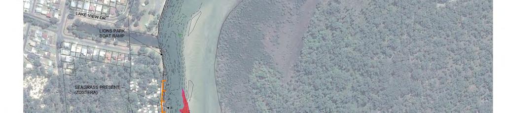
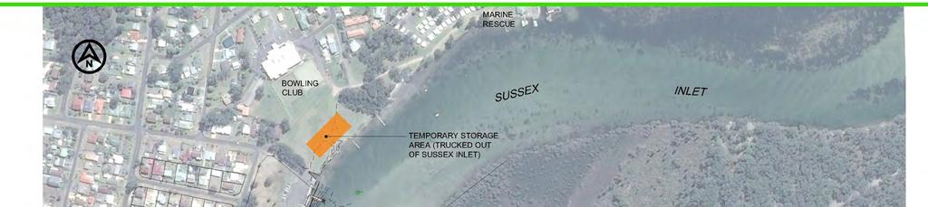
21 Figure 8 Callala Beach nourishment profile Sussex Inlet Navigation Channel The Sussex Inlet Navigation Channel Dredging methodology should be read in conjunction with Figure 4. The mobilisation and demobilisation of water-based plant and equipment would be from the Lions Park boat ramp (Lakehaven Drive) or the adjacent reserve behind the bowling club. The land-based construction compound is proposed in the same area. The dredging and placement methodology would depend on the Contractor s available plant, but would likely occur using a small cutter suction dredger (CSD) pumping sand directly to the western foreshore of the lower inlet to address erosion, and/or the temporary storage area at northern edge of the sand delta. The dredged sand would be dewatered at these sites. If sand is pumped to the temporary storage area and dewatered, it would be removed as required by an excavator and barge, and unloaded at its destination. Potential destinations include: the western foreshore of the lower inlet to address erosion between Alamein Caravan Park to the Big Dipper, in particular in front of The Haven Resort and Alamein Caravan Park; the canals system to address erosion; the reserve behind the bowling club to be locally stockpiled, loaded into trucks and removed from site. An alternate methodology to dredge sand could be with a backhoe dredger (BHD) or barge mounted excavator loading barges, and transporting and unloading to the three Shoalhaven Dredging REF


22 previously mentioned destinations. A BHD would dredge at a significantly slower rate to a CSD, and may also be more limited with tidal currents, however double handling would be reduced compared to temporally storing material on the sand delta. Sand material used to address foreshore stabilisation should occur with the use of structures such as flow retards and groynes. A trial is proposed in front of The Haven and Alamein Caravan Park that implements geotextile containers that would reduce flows and assist in retaining placed sand. Stormwater runoff into areas would also be considered. Further information on the nourishment of this foreshore is provided in Appendix A. A concept for a typical section is shown on Figure 9. The final profile and layout of the foreshore stabilisation works would be subject to detailed design and in particular, consider to presence of seagrass. Plate 9 View of flood tide delta in Sussex Inlet Plate 10 Reserve behind Bowling Club Plate 11 Eroded foreshore in front of The Haven Park Plate 12 Eroded foreshore at Alamein Caravan Shoalhaven Dredging REF
23 Figure 9 Typical section of flow retard/groyne Sussex Inlet Canals (Rivera Keys Estate) The Sussex Inlet Canals (Rivera Keys) methodology should be read in conjunction with Figure 7. Due to access, it is most likely that the work in the canals would be conducted from the water, ie a small excavator on a barge (that may come to shore), and another barge that would move to and from the sand source/dredging area. Due to available area, access to water, and separation from residents, the location of the sand stockpile is proposed at the end of Harbord Road unless all sand is sourced directly in the canals and/or from the navigation channel dredging. The reserve next to the Island has also been considered as a second stockpile area option. The barges and excavator would also be launched at one of these reserves adjoining the canals, or at a local ramp such as Chris Creek Boat Ramp if small enough to pass beneath the bridges to enter the canals. It is preferable that sand is sourced within the canal system for nourishment and/or that similar quantities of sand imported are also removed from the system or placed in an inactive area not likely to remobilise. The nourishment profile should resemble the original construction profile shown in Figure 10. The upper portion of nourishment profile (immediately in front of walls) should be considered for vegetation with primary vegetation species where possible. Nourishment may not be suitable for some seawalls, in particular for those exposed to higher currents/ boat wash. Alternate treatment such as rip-rap may be considered in consultation with local property owners. Unless trees near a seawall are causing damage to the seawall, they are not recommended to be removed. Tree roots can often enhance bank stability and may exacerbate erosion if removed. Shoalhaven Dredging REF


24 Figure 10 Original construction profile at Rivera Keys (PWD, 1989) Plate 13 Beaches requiring nourishment Plate 14 Failing seawall on bend Plate 15 Vegetation in front of wall providing erosion control Shoalhaven Dredging REF


25 Plate 16 Root ball providing bank support Plate 17 Potential sand source in canals at stormwater outlets Lake Conjola Configuration Dredging The Lake Conjola Configuration Dredging methodology should be read in conjunction with Figure 11. The mobilisation and demobilisation of water-based plant and equipment would be from the Cunjurong or Conjola Caravan Park boat ramp. The land-based construction compound is proposed at the adopted mobilisation/demobilisation area. Dredging of sand is proposed using a small cutter suction dredger (CSD) pumping all sand onshore to be dewatered. At least half of the sand volume would be pumped directly to the southern foreshore to address erosion. Up to half of the dredge volume would be pumped either to the southern foreshore or the northern foreshore to be stockpiled temporarily and removed from site, to nourish Mollymook Beach (3,000 m 3 ) with the remainder for sale. The Mollymook Beach nourishment plan and typical section is shown in Figure 12 and Figure 13 respectively. The dredge pipeline would likely be sunk where required to allow for passing vessels. It may also be possible to use a backhoe dredger (BHD) and barges to transport the dredged material. Dredging activities would be localised where possible, and carried out in the winter months when the area is less widely used, and to avoid the breeding season of migratory shorebirds. Popular swimming areas such as near the entrance on the Cunjurong side, or near the caravan park on the Lake Conjola side, would expect limited effects. Dredged sand would be placed in a manner to manage return water flow back into the waterway, and may require reworking of dredged sand with land-based plant and equipment. The dewatered sand to be removed from site would be handled with backhoes loading to trucks. Shoalhaven Dredging REF
 conceptual understanding of estuary")

 Shoalhaven")
26 Figure 11 Regime state overlay based on Patterson Britton & Partners (PBP,1999) conceptual understanding of estuary morphodyhamic processes overlaid on a recent (Nov 2013) aerial photograph Plate 18 View to Lake Conjola from Cunjurong Plate 19 Potential temporary storage area to trucking off site (same as note on dwg) Shoalhaven Dredging REF

27 Figure 12 Mollymook Beach priority nourishment area Figure 13 Mollymook Beach nourishment profile Shoalhaven Dredging REF
28 2.2.5 Mollymook Beach Creek and Dune Protection Works The Mollymook Beach Creek and Dune Protection Works methodology should be read in conjunction with Figure 6. The construction compound is proposed on the adjacent reserve area, between 2 Mitchell Parade and the bridge. The BDPS works would require rock imported to site to construct the rock revetment component of the structure. The geotextile containers would be filled with sand as either surplus from the nourishment works, or sand excavated to found the structure. Conventional land-based plant and equipment would be suitable, however, the water table would be encountered when founding the structures and should be considered in the contractor s methodology if dewatering and coffer dam type arrangements are required. The sewer pumping station overflow pipe and a stormwater outlet from Mitchell Parade would also need to be incorporated into the rock revetment. The toe of the rock revetment should be founded to R.L. -2.0m AHD or at bed rock if encountered at a higher level. It is expected bed rock around the bridge abutment would be encountered at -0.5m AHD, dropping to a level of -2.0m AHD or lower around 10 to 15m downstream of the bridge. The crest of the rock revetment would be constructed to R.L.4m AHD just above existing ground levels and be covered with sand and vegetated. Any future end state rock revetment works to extend northward is described in RHDHV (2012) would be founded to R.L. -2m AHD and constructed to a crest level of up to R.L. 6.2m AHD. End state : rock revetment works are not part of this project. The geotextile container component of the BDPS would be designed for a life of 15 to 20 years to protect the proposed sand nourishment works. The structure would be founded to R.L. -0.5m AHD with a falling toe to provide scour protection to -2.0m AHD. The crest of the structure would be constructed to R.L. 2.1m AHD and would be expected to be overtopped in extreme storm events. Typical sections of the works are shown on Figure 14. The structure will be included into Council's 'Coastal and Estuary Asset Management Plan' and maintained under Council's coastal maintenance program. Shoalhaven Dredging REF
29 Figure 14 Typical Sections for Mollymook Beach Creek and Dune Protection Shoalhaven Dredging REF


 and sometimes blended depending on grain size and sorting")

30 Plate 20 Looking upstream to bridge bridge Plate 21 Looking downstream from Plate 22 Looking south along creek entrance Plate 23 Looking upstream on north side of creek bank 2.3 Sale of Sand The Shoalhaven Citywide Dredging Feasibility Study (Peter Spurway and Associates, 2014) discusses the sale of sand as a source of funding. It noted beach sand is favoured by private industry as it provides the best level of workability for concrete, although blending with manufactured sand from crushed rock is being used by the Sydney industry for a cheaper resource. For beach sand to be suitable in concrete production it must be processed (generally washed and screened) and sometimes blended depending on grain size and sorting of the material. The cost of processed beach sand in Sydney varies from $40 to $60 per tonne, or $60 to $90 /m 3. However, sand resources on the south coast are more plentiful and therefore cheaper. It is proposed that an Expression of Interest (EOI) document be released to gauge the willingness of private companies to enter into a partnership with Council to undertake identified dredging activities and/or purchase dredged sand. The aim of this approach is to subsidise the cost of the proposed dredging works. It should be noted that the extent Shoalhaven Dredging REF
31 of dredging is for navigation purposes and environmental protection, and not to remove additional sand to supply to industry. It is proposed that up to 6,000 m 3 and of sand in total may be available for sale comprising of 3,000 m 3 from Lake Conjola, and also 3,000 m 3 from Sussex Inlet. Prior to placing dredged sand in trucks it would need to be dewatered and spadeable. In the case of the Lake Conjola Configuration Dredging, the dredged sand is proposed to be pumped onto a sandy foreshore area that is conducive to dewatering, and easily accessible by trucks. It is also planned to truck sand from Lake Conjola to Mollymook for beach nourishment purposes. In the case of the Sussex Inlet Navigation Channel, the only practical area to load trucks with dredged sand is the reserve behind the Bowling Club. It is not feasible to pump sand directly to the Bowling Club area with the establishment of appropriate environmental and water management controls for receiving and dewatering dredged sand on a grassed reserve in a residential area. However, it would be seen to be feasible if dewatered sand was mechanically placed on the Bowling Club reserve from a barge. This could be achieved by loading barges with dredged sand from the temporary sand stockpile area on the flood tide delta. Alternatively the dredging could be carried out directly with a backhoe dredger loading barges, dewatering the barges, and unloading onto the reserve behind the Bowling Club reserve. The stockpiled sand prior to loading into trucks would require careful managed to prevent windblown sand, and be progressively removed soon after being placed onshore to minimise the area occupied and height. The feasibility of selling the sand from Lake Conjola and Sussex Inlet would be confirmed through the EOI process. From discussion with NSW Crown Lands who have sold dredged sand in the past, it is understood that it can be difficult to attract interest from the concrete industry for the purchase of dredged sand and have previously sold dredged sand as fill. NSW Crown Lands have found that dredging projects that require sand to be hauled from site benefit most from the sale of sand as the purchaser would pay for the haulage costs in addition to a per cubic rate for the sand. It is well documented that a sand proven suitable for use in concrete production will fetch a much higher price than sand sold to be used as fill. The value of sand would dependent on supply and demand economics of an area. Peter Spurway and Associates (2014) noted that payment to the State of a royalty may be applicable for any extraction activity, particularly for sale or profit. Crown Lands advised in 2014 that the royalty rates for sand varied between $0.75 to $3.00 /m 3. If material is being removed under a maintenance dredging contract to improve navigation and is being sold as part of the contract agreement to recover part of the cost, or is placed back on Crown land for beach nourishment, then the project may be approved by Crown Lands as exempt from royalty payment. 2.4 Program and Sequencing Shoalhaven City Council plans to undertake the majority of the works in 2015 with the Callala Beach nourishment activities to occur in the second and third quarter of Timing for the dredging in Sussex Inlet Canals is yet to be determined. Shoalhaven Dredging REF
32 The three dredging projects proposed for 2015 would generally occur in series with some overlap of construction activities to occur between sites. The series of projects is proposed to commence in July to minimise impacts on recreational use of the areas and the shorebird breeding season. This would also allow the three projects to be completed by late November/early December. The Mollymook Beach works would occur in parallel with the Lake Conjola dredging. The sequence of dredging and nourishment activities is proposed as follows: Lake Conjola dredging - July to September 2015 Mollymook Beach Creek and Dune Protection July to September 2015 Currambene Creek dredging September to October 2015 Sussex Inlet dredging October to December 2015 Callala Beach nourishment - April to August 2016 Disruption to waterway uses and reduction of the overall dredging program could be reduced if dredging was carried out outside of standard working hours. However, this would need to be balanced against potential afterhours noise impacts for residents in the vicinity of the dredge and potential booster pumps. In particular, a dredger working in Currambene Creek would need to accommodate local navigation traffic that would impact on dredging productivity. By dredging outside of the standard construction hours, dredging productivity could be maintained and the dredger removed from the area earlier. It is expected that the dredging in Currambene Creek could also take place during evening and night periods to expedite the dredging project with a net beneficial outcome for the local community and economy. Shoalhaven Dredging REF
33 3 STATUTORY REQUIREMENTS 3.1 Approvals Framework Under SEPP (Infrastructure) 2007, a public authority, is allowed to carry out a range of public activities without development consent, provided appropriate consultation with all relevant government authorities and environmental impact assessment under Part V of the Environmental Planning & Assessment (EP&A) Act, 1979 is undertaken. As dredging at Currambene Creek Navigation Channel, Sussex Inlet Navigation Channel, Sussex Inlet Canals and Lake Conjola is being undertaken to improve navigation for safety reasons or in connection with existing wharf and boating facilities, clauses 68 and 129 of SEPP Infrastructure are applicable to the proposed dredging and reuse of dredged sand. Division 13 port, wharf and boating facilities Clause 68: routine maintenance works (including dredging, or bed profile levelling, of existing navigation channels if it is for safety reasons or in connection with existing facilities). Division 25 waterway or foreshore management activities" Clause 129: development for the purpose of waterway or foreshore management activities including bank management, coastal management and beach nourishment. The works described above are permitted without consent when carried out by, or on behalf of a public authority. Accordingly, the proposed dredging works are Part 5 Activities under the Environmental Planning and Assessment Act 1979 (EP&A Act). Section 111 of the EP&A Act confers a duty on the determining authority to consider the environmental impacts of an activity and Clause 228 of the EP&A Regulation 2000 lists factors to be taken into account. 3.2 Other Approvals The following regulatory approvals are applicable to the proposed maintenance dredging works: Permit under Section 205 of the Fisheries Management Act 1994 to cut, remove, damage or destroy marine vegetation. Public Authorities are not required to obtain a permit under Section 201 for dredging and reclamation works where the works are authorized under the Crown Lands Act or by any other relevant authority (excluding Council). Given that a Crown Lands licence would be required for all dredging sites, a dredging permit from NSW DPI would not be required. Under Section 199, DPI Fisheries must be notified of dredging and reclamation works intended to be carried out, or authorised by a public authority, and matters raised by DPI Fisheries must be considered. Ministers consent is required under the Marine Estate Management (Management Rules) Regulation 1999 to harm animals, plants and habitat in a marine park (habitat protection zone Currambene Creek dredging, temporary placement area and Callala Beach) and for dredging within a Sanctuary Zone. Shoalhaven Dredging REF
34 A licence is required from NSW Trade and Investment (Crown Lands) under Section 34 of the Crown Lands Act The licence applies to the dredging and beach nourishment activities carried out on Crown land (except where SCC is the appointed reserve trust manager of a site), including submerged Crown land. Environment Protection Licence (EPL) under Section 43 for a scheduled activity under the Protection of the Environment Operations Act 1997 (POEO Act) is only required for maintenance dredging involving extraction of more than 30,000m 3 of material in one year. The proposed dredging is therefore not a scheduled activity. Council may however apply for a licence to control the carrying out of nonscheduled activities for the purpose of regulating water pollution (Section 43 POEO Act). The material to be dredged is clean sand. Material from Currambene Creek Navigation Channel, Sussex Inlet Navigation Channel and Lake Conjola is classified as Virgin Excavated Natural Material (VEMN) under the POEO Act. Material from the Sussex Inlet Canals is classified as Excavated Natural Material (ENM) (refer Section 5.5.3). An EPL for disposal of dredged material from Currambene Creek Navigation Channel, Sussex Inlet Navigation Channel and Lake Conjola is not required as the dredged material is VENM and will be used for foreshore and dune works. An EPL for the beneficial reuse of ENM from the Sussex Inlet Canals is also not required as it would fall under the resource recovery exemption for ENM under Clause 93 of the POEO (Waste) Regulation 2014 for waste disposal (application to land). Record keeping and reporting requirements of the resource recovery order would apply. Under the Water Management Act 2000 (WM Act) an approval is required to undertake controlled activities on waterfront land, unless that activity is otherwise exempt. Controlled activities include excavating or depositing material on waterfront land (within 40 metres of a waterway). Water Management (General) Regulation 2011 sets out a number of exemptions in relation to controlled activities. Under the regulation, a public authority does not need to obtain a controlled activity approval for any controlled activities that it carries out in, on or under waterfront land. Council therefore does not need to seek controlled activity approval for the proposed dredging and reuse activities. With regards tho the Mollymook Beach Creek and Dune Protection, under SEPP (Infrastructure) 2007, clauses 129 (2A) details that for any proposed new protection works on the coast, in the absence of a Coastal Zone Management Plan being in force (which is the case in this instance), needs to be considered by the NSW Coastal Panel with the exemption of the placement of sand (including for beach nourishment) or sandbags. Therefore, the rock component of the protection works would be provided to the NSW Coastal Panel for review and consideration following preparation of the REF and detailed design. Shoalhaven Dredging REF
35 4 CONSULTATION 4.1 Public Authority Consultation The Public Authorities consulted for the Shoalhaven Dredging Project comprise: Shoalhaven City Council NSW Crown Lands Department of Primary Industries (DPI Fisheries) Office of Environment & Heritage (OEH) Roads and Maritime Services (RMS) Environment Protection Authority (EPA) Jervis Bay Marine Park NSW National Parks and Wildlife Service Meetings with Public Authorities attended by RHDHV were held on 19 November The meetings provided information on the purpose, opportunities, and methodology for the current dredging proposals. Issues raised during these meetings and subsequent correspondence to be addressed in the environmental assessment are discussed in Section 4.2. A copy of this correspondence is provided in Appendix B. 4.2 Issues Raised Issues raised by the Public Authorities have been tabulated and provided in Appendix C. In summary these issues relate to the following: Coastal and Estuary Processes Impacts on estuary dynamics Impacts on foreshore stability Consideration of beneficial re-use of dredge sand Sediment and Water Quality Characterisation of sediment and suitability for reuse Turbidity at dredging site Management of spills Impacts on water quality at disposal sites Ecology Disturbance to aquatic environments including marine vegetation (mangroves, seagrass, saltmarsh, seaweeds), wetlands and riparian habitats Impacts of sand transport into reef environment Shoalhaven Dredging REF
36 Threatened and migratory birds Pied Oystercatchers, Little Terns, Black-tailed Godwits, Red Knots and Eastern Curlews, Double-banded Plovers, and Hooded Plovers Impacts on foreshore ecology from sand placement Aboriginal Cultural Heritage All areas of impact would need to be covered by a due diligence assessment Noise noise associated with dredging, sand transport and placement construction traffic noise Access and Recreational Use Impacts on navigation during dredging and other community use of the waterway and foreshore area Impacts on public safety (including pedestrians, vessels and other users) during sand transport 4.3 Consultation with Community Community Consultation sessions were held to present and discuss the project proposals and were convened by Council with Peter Spurway (from Peter Spurway & Associates Pty Ltd) assisting with the presentations representing Royal HaskoningDHV. Community meetings to discuss the dredging projects were undertaken as follows. Currambene Creek / Callala Beach, Huskisson Community Centre 8/12/14 Sussex Inlet and Canals, Sussex Inlet Community Centre 9/12/14 Lake Conjola / Mollymook Beach, Milton CWA Hall 9/12/14 Council advertised these meetings in local newspapers. Council also sent invitations to relevant Community Consultative Bodies (CCBs), beachfront owners, and residents at Callala Beach and Mollymook Beach. A summary of issued raised at these community meetings are as follows: Currambene Creek Navigation Channel Keep navigation channel usable during dredging Longevity of dredged channel Myola Spit is a bird nesting area. Callala Beach Remediation Discuss recovery of existing vegetation on incipient and foredune, including need or otherwise for replanting of grasses Windblown sand issue for residents. Shoalhaven Dredging REF
37 Sussex Inlet Navigation Channel Public opposition expressed for the need of dredging Environmental effects of dredging questioned and potential impacts on channel erosion Dredging too close to the banks could cause further erosion Keep navigation channel available during dredging Longevity of dredged channel. Sussex Inlet Canals (Rivera Keys Estate) Consultation meetings did not cover the canal estate. This would be subject to separate consultation by Council at a later date. Lake Conjola Configuration Dredging Possibility of sand placement behind dunes in old dredged channel. Mollymook Beach Remediation Road damage - hauling sand through Cunjurong Point village and along Bendalong Road Pavement restoration a major issue for local community Truck noise at Cunjurong would affect a small number of residents. Additional consultation has also been undertaken in relation to management of the canal estates, and with the Callala Beach, Lake Conjola and Manyana/Cunjurong communities. The draft Review of Environmental Factors would be placed on public exhibition in March When CCBs and beachfront owners at Callala Beach and Mollymook Beach nourishment dates are finalised would be advised by letter of the exhibition period. Council staff are happy to provide further information to CCBs and attend CCB meetings on request. Shoalhaven Dredging REF
38 5 EXISTING ENVIRONMENT 5.1 Tenure, Land Use and Zoning Land tenure and zoning under the Shoalhaven Local Environment Plan 2014 for each of the dredging and placement areas is summarised in Table 2. All dredge areas (except Sussex Inlet Canals) are Crown Land under control of NSW Trade and Investment (Crown Lands). Transport routes, temporary placement areas and final placement areas also comprise Crown Land either under the control of NSW Trade and Investment (Crown Lands) or SCC (appointed reserve trust manager). The Currambene Creek dredge area is also located within the Jervis Bay Marine Park (refer Figure 2). The following zonings apply: Special Purpose Zone - the wharf area (dredge area) at Huskisson Habitat Protection Zone - the dredge area at the entrance to Currambene Creek, the eastern side of Currambene Creek (temporary placement area), and Callala Beach (placement area) Sanctuary Zone - the seaward end of the dredge area These areas are regulated by the Marine Parks (Zoning Plans) Regulation Restrictions on activities relevant to the project are as follows. Sanctuary Zone A person must not carry out any dredging activity or beach replenishment activity in the sanctuary zone of a marine park. A person does not commit an offence if the dredging activity or beach replenishment activity is carried out with the consent of the relevant Ministers. Consent is not to be given to the carrying out of a dredging activity or beach replenishment activity in the sanctuary zone of a marine park unless the relevant Ministers are satisfied that the activity is necessary to prevent a serious risk of injury to a person, damage to property or harm to the environment. Habitat Protection Zone A person must not, while in the habitat protection zone of a marine park: (a) harm, or attempt to harm, any animal (other than fish), or (b) harm, or attempt to harm, any plant, or (c) damage, take or interfere with, or attempt to damage, take or interfere with, any part of the habitat (including soil, sand, shells or other material occurring naturally within the zone), except with the consent of the relevant Ministers. Consent is only to be given for research, environmental protection, public health, traditional use or public safety purposes, or for the purposes of an ecologically sustainable use that does not have a significant impact on fish populations within the zone or on any other animals, plants or habitats. There are no current Native title claims listed on the NTT website for the Shoalhaven LGA and there are currently no ALC affecting the study areas Shoalhaven Dredging REF
39 Table 2: Summary of Land Tenure and Zoning SITE TENURE ZONING CURRAMBENE CREEK ENTRANCE Dredge Area Submerged Land - Crown Land (Reserve & Reserve ) W2 Recreational Waterways (LEP), Special Purpose Zone, Habitat Protection Zone and Sanctuary Zone (Marine Parks Regulation 1999) Temporary Placement Area Submerged Land - Crown Land (Reserve & Reserve ) Adjacent reserve above MHWM - Crown CCM (Reserve [Management: Devolved to SCC] & part Reserve ) Habitat Protection Zone (Marine Parks Regulation 1999) E1 National Parks and Nature Reserves (LEP) Haul Route Crown CCM (Reserve [Management: Devolved to Council: SCC] & part Reserve E1 National Parks and Nature Reserves ) Placement Area Callala Beach: Crown Land Habitat Protection Zone (Marine Parks Regulation 1999) SUSSEX INLET CHANNEL Dredge Area Submerged Land - Crown Land (Reserve 56146, Reserve & Reserve ) W1 Natural Waterways and W2, Recreational Waterways Temporary Placement Areas In front of Bowling Club, part Reserve (Management: SCC held under Trust) RE1 Public recreation Within channel northern edge of sand delta, Crown Land (Reserve 56146, Reserve W2 Recreational Waterways & Reserve ) Placement Areas Foreshore stabilisation sites: The Haven - Crown Land (Reserve 56146, Reserve & Reserve ) Alamein - Crown Land (Reserve 56146, Reserve & Reserve ) E1 National Parks and Nature Reserves RE1 Public recreation SUSSEX INLET CANALS Dredge Area Council owned canals R2 Low Density Residential Placement Areas Eroded areas in front of seawalls: Council owned canals R2 Low Density Residential LAKE CONJOLA Dredge Area Submerged Land - Crown Land (Reserve & Reserve ) W1 Natural Waterways Temporary Placement Areas Adjacent reserve above MHWM (Reserve & ) RE1 Public recreation Placement Area Mollymook, Blackwater Creek: - Submerged Land incl Blackwater Creek - Crown Land (Reserve 56146, Reserve & Reserve ) - Above MHWM north of Blackwater Creek (Reserve , Management: SCC Community Land) W1 Natural Waterways RE1 Public recreation Shoalhaven Dredging REF
40 5.2 Shoreline Morphology and Bathymetry Currambene Creek Navigation Channel Currambene Creek is classified as an intermittently closed, saline coastal lagoon (Roy et al, 2001). Although, it is unclear when the creek was last closed, and based on site observations, documented history and anecdote any predisposition to natural closure would have to be very low. The creek provides mooring facilities for a number of vessels. The entrance is partially protected from south and east seas by Voyager Memorial Park and a rock reef 500 m east of the entrance (Figure 2) A hydrographic survey conducted by Shoalhaven City Council in 2011 indicates the channel bed is generally -3 to -4 m AHD. The southern shoreline around Voyager Memorial Park is relatively steep (Figure 3). Callala Beach is approximately 5 km long and extends from Callala Point to Myola Spit. The entrance to Currambene Creek is located south of Myola Spit and Callala Creek crosses the northern end of Callala Beach (SMEC, 2006). A terrestrial survey was undertaken by Shoalhaven City Council in Four transects perpendicular to the foreshore were obtained from in front of the village at Callala Beach and an additional transect was obtained south of the village. The survey indicates the vegetation line generally lies between 1.8 m and 1.85 m AHD and the average beach slope seaward of the vegetation line to 0 m AHD is approximately 4 to 5.25 %. The crest elevation of the dune is between 6.1 m and 6.6 m AHD and is located approximately 65 m to 85 m from 0 m AHD. The land behind the dune crest slopes gently away from the water towards the northwest. The dune crest elevation south of the village is 4.1 m AHD and it is likely to continue to decrease in elevation towards Myola Spit. Sussex Inlet Navigation Channel Sussex Inlet is a narrow channel linking St Georges Basin to the Ocean (Figure 1 and Figure 4). Roy et al, (2001) indicates St Georges Basin is a wave dominated barrier estuary. The entrance of Sussex Inlet is protected from north east and east swells by St Georges Head and partially protected from southerly swells by Farnham Headland and a rock island (SCC, 2013). There are no recorded closures of the entrance channel. In NSW, longshore sediment transport generally occurs in a northward direction. However, due to the topography around the entrance to Sussex Inlet, the direction of longshore sediment transport is locally reversed resulting in a southerly movement of sand (Boardman, 2009). In addition, reduced wave action results in a relatively low volume of littoral zone sand movement. Flood tide velocities within the entrance are greater than ebb tide velocity, which results in a net movement of marine sediments from the entrance towards the basin. This leads to a deposition of these sediments within the navigation channel. During storm events, freshwater flows result in sediment transport towards the ocean. The sediments are deposited in a sand bar formation near the entrance. Sussex Inlet is eroded by freshwater flows resulting in a deeper and straighter navigation channel. Shoalhaven Dredging REF
41 Shoreline erosion within the estuary is linked to freshwater flows and spring tides and it is accelerated by boat wash. Parts of Sussex Inlet are 4 knot zones to minimise the effects of boat wash while the majority of the inlet is an 8 knot zone. The latest hydrographic survey obtained from Shoalhaven City Council is dated November It indicates the navigation channel is generally between -1 m and -2 m AHD. Sussex Inlet Canals (Rivera Keys Estate) Sussex Inlet Canals are located downstream of St Georges Basin. The canal network is an artificial waterway, which were excavated with the purpose of providing navigable water access (SCC, 2014). The land where the canals are located was a wetland (Figure 7). The shoreline within the canals comprises canal walls and beach formations. The design of canal walls can vary throughout the canal network however, is generally consistent with the Canal Subdivisions Conditions & Guidelines document (PWD, 1992). In places, the design included dry beaches to provide partial support for the revetments. Some of these beaches have been eroded and require reinstatement to stabilize the revetments (Canal Estates Management Plan, 2014). The St George Basin Flood Risk Study (Webb Mckeon and Associates, 2006) suggests St George Basin comprises clean or muddy sand. The St George Estuary Management Plan l(scc, 2013) indicates marine sands within Sussex Inlet are transported from the entrance to about 2.75 km upstream by wave and tidal currents, which is downstream of the entrance to the canal network. Between 2.75 km from the entrance and the drop over within Sussex Inlet, the main sediments are reworked clean white sands derived from older barrier dunes. Some of these sediments may be present in parts of the canal network. The main sediments within the canal network are expected to be variable and comprise reworked sand and sandy mud, some of which have been eroded from beaches within the canal network and alluvial sediments comprising sand and silt. The Canal Estates Management Plan (SCC, 2014) targets a channel depth greater than 0.6m at mid tide. Therefore, the aim is to maintain a canal bed elevation of -0.4m AHD. Original design plans for the canals prepared by Department of Public Works in 1974 suggest the typical canal was 2.0m deep. Siltation has been identified as an issue in some locations within the Canal Estates Management Plan (SCC, 2014), which is the main cause of reduced water depths. Lake Conjola Configuration Dredging Lake Conjola is classified as a wave dominated barrier estuary (Roy et al, 2001). Sloss et al (2009) examined the Holocene sedimentological and geomorphological history of Lake Conjola. They conclude that remnants of the last interglacial barrier system are present at depth beneath the tidal delta and entrance channel to Lake Conjola. As the sea-level rose, remnants of the last interglacial barrier were breached and sediments accumulated, forming, a flood delta at the mouth of the drowned river estuary. Further Shoalhaven Dredging REF
42 restrictions at the lakes entrance lead to the development of back-barrier depositional environments. The bathymetry, flood delta and sediment transport at the entrance is largely dependent on flood events and storm surge. PBP (1999) suggest that during flood events, freshwater flows scour the entrance channel, causing a straighter, deeper and wider entrance channel. The scoured sediments are deposited in a near shore, shallow bar formation. After a storm event, the sediments in the sand bar are mobilised by tidal and wave induced currents, and redeposited on the tidal delta near the entrance channel. During large coastal storms, the entrance channel may be infilled, causing the entrance to close. This is caused by storm wash pushing large volumes of sand over the spit and into the entrance channel. In addition, during lengthy dry spells, the entrance may be closed off by an accumulation of wind-blown sediments in the entrance channel. Mollymook Beach Creek and Dune Protection Works Mollymook is an open beach approximately 2 km long. It is flanked by Banister Point to the north and an intertidal rock shelf to the south. The central and northern portion of the beach is moderately well exposed to ocean swell, which maintains an attached bar cut by rips. The southern portion of the beach is somewhat protected by a rock reef and the intertidal rock shelf, which reduces ocean swell and usually maintains a continuous attached bar (SLSA, 2015). Blackwater Creek crosses the southern end of Mollymook Beach. Blackwater Creek, like Mollymook Creek further north along Mollymook Beach is defined as an intermittently closed saline coastal lagoon (Roy et al. 2001). When a breakout of the closed creek coincides with a coastal storm, heavy erosion ensues on the beach surrounding the creek entrance. 5.3 Coastal Processes Wind Climate The wind climate in the region is best represented by the following BOM weather stations: Nowra RAN Air Station AWS (Station No ). Data is available from 28th November 2000 to 30th September (Station No operated at a similar location from 1942 to 28th November 2000); and, Jervis Bay (Point Perpendicular Lighthouse) (Station No ). Data is available from 1899 to 30th June A review of monthly wind roses available on the BoM website (accessed 5 th December 2014) indicates that winds are seasonal and follow a typical coastal trend. In winter, the winds are predominantly light to moderate north-westerlies in the morning and gentle to fresh westerlies or southerlies in the afternoon. Summer is driven by coastal sea breezes and the wind is predominantly light to fresh southerlies in the morning with north-westerlies common during spring and early summer. Afternoon breeze is predominantly gentle to fresh north-easterlies and south-easterlies. Shoalhaven Dredging REF
43 5.3.2 Rainfall Waves The 1 hour wind speed for the design of structural members is presented in Table 3. The wind speed is corrected for 10 m above a water body, which is the standard criterion used for wind wave hindcasting. Table 3: AS Hour Design Wind Speed Direction 1 hour Wind Speed (m/s) (10 year ARI) AS N 18.0 NE 18.0 E 18.0 SE 21.4 S 20.3 SW 21.4 W 22.5 NW 21.4 Rainfall in the project area is available from numerous locations. Representative rainfall data sets are analysed from the following sites: Sussex Inlet Bowling Club weather station (Station No ). Data is available from 1952 to present and annual average rainfall is mm. Nowra Treatment Works (Station No ). Data is available from 1896 to present and annual average rainfall at the site is and mm. Rainfall is relatively uniform throughout the year and it is marginally higher in early winter and marginally lower in Summer. The annual average rainfall at other locations within the region falls between the values for the sites given above. Nine offshore Waverider buoys operated by Manly Hydraulics Laboratory are located off the NSW coast between Eden and Brisbane. An analysis of the data was presented in Long Term Trends in NSW Coastal Wave Climate and Derivation (Shand et al, 2011). The results of the analysis are presented in Table 4. It indicates that the wave climate off the NSW coast is relatively uniform. 1 The AS regional wind speeds were converted to site wind speeds as per the methodology outlined in the Standard. This involved applying wind directional multipliers for the 8 cardinal directions and then converting to 1 hour duration wind speeds using the applicable equation presented in Figure II-2-1 of Resio et al (2002). It was assumed that the terrain/height multiplier (using Terrain Category 2 and 10m height), shielding multiplier and topographic multiplier were all equal to unity. Shoalhaven Dredging REF
44 Table 4: Analysis of Offshore Wave Data in NSW (Shand et al) Range of values from 9 locations Mean Significant Wave Height (m) Mean Significant Wave Period (sec) % Exceedance Wave Height (m) % Exceedance Wave Period (sec) Currambene Creek Navigation Channel The site is exposed to ocean swell from the south east. However, ocean swell would diffract as it penetrates the entrance of Jervis Bay, resulting in the wave crest spreading and the wave height reducing. SMEC (2006) adopted the offshore wave height for the investigation of Callala Beach coastal hazards. The wave height was based on a storm event that had a 5% chance of being exceeded in the next 50 years. This resulted in an AEP of less than 0.1%, a significant wave height of 4.5m and maximum run-up of 6.0 m assuming a dune foreshore. Currambene Creek is a 4 knot zone, however, the speed limit in Jervis Bay is unlimited. The navigation channel is located at the point where boats can legally accelerate. This may produce significant boat wash. As such and based on experience in Sydney Harbour and at other sites, boat wash up to 0.4 m is estimated to occur at the site. Wind wave hindcasting using methods outlined in the Coastal Engineering Manual (USACE) have been conducted at the site. The results are presented in Table 5. The predicted 1.0 m significant wave height is less than the significant wave height predicted by SMEC (2006), which may propagate to the site from the south east. Table 5: Wind-wave hindcasting results using methods from USACE (2002) Site Fetch (m) Fetch Direction Wind Speed for a 10 year ARI event from Table 1 (m/s) Significant Wave Height (m) Peak Wave Period (sec) Currambene Creek Entrance Channel 10,000 East and North East Sussex Inlet Navigation Channel Sussex Inlet Canals (Rivera Keys Estate) 1,000 South West Sussex Inlet Navigation Channel Swell penetration at the site would be minimal. As previously mentioned, the entrance is partially protected by St Georges Head, Farnham Headland and a rock island (SCC, Shoalhaven Dredging REF
45 2013). Furthermore, the St Georges Basin revised Estuary Management Plan (SCC, 2013) indicates wave induced sediment transport is limited to the first few hundred metres of Sussex Inlet, which implies swell wave height is minimal past this point. The site lies within a 4 knot zone. Boat speeds equal or lower than 4 knots are generally accepted to produce negligible wash. As such and based on experience in Sydney Harbour and at other sites boat wash up to 0.2 m is estimated to occur at the site. Due to the limited fetch in any one direction within the navigation channel, wind waves would be minimal. Wind wave hindcasting using methods outlined in the Coastal Engineering Manual (USACE, 2002) have been conducted at the site. The results are presented in Table 5. This value is considered conservative as the entrance configuration is likely to further restrict wind wave generation. Sussex Inlet Canals (Rivera Keys Estate) Wave action at the site is considered to be minimal. The site is outside the zone of swell penetration and lies within a 4 knot zone. Therefore, swell would be insignificant and boat wash would be less than 0.2 m. Due to the limited fetch in any one direction within the canals, wind waves would be minimal. Wind wave hindcasting using methods outlined in the Coastal Engineering Manual (USACE) have been conducted at the site. The results are presented in Table 5. This value is conservative as it pertains to an upper bound fetch distance and assumes the terrain is generally flat with a few scattered obstructions, however, the land surrounding the canals is occupied by residential developments. Lake Conjola Configuration Dredging With the exception of occasional swell penetration, wave action at the site it considered to be minimal. The site lies within a 4 knot zone. Therefore, boat wash would be insignificant. Due to the configuration of the entrance channel, wind waves would be fetch limited and would be insignificant. Ocean swell in the entrance channel may be significant, depending on entrance conditions and water level. The Coastal Engineering Manual (USACE, ) specifies that wave height is commonly limited to 0.78 times the water depth before breaking occurs and a large portion of wave energy is dissipated during breaking. Ocean wave heights are presented in Table 4. When the entrance is closed, ocean swell would not occur at the site. In addition, during normal conditions when the entrance channel is open, ocean swell would have broken and largely dissipated, and minimal propagation would occur to the site where dredging is proposed. However, during storm events when ocean levels are elevated, ocean swell protraction and wave wash over at the site may be significant. A detailed analysis of ocean waves at the entrance of Lake Conjola has not previously been undertaken, however desktop methods are suitable for design development of the proposed dredging. Mollymook Beach The wave climate at the site is dominated by ocean swell. SMEC (2006) conducted an analysis of ocean swell and near shore wave height. The results of the analysis are Shoalhaven Dredging REF
46 presented in Table 6. Boat wash and wind generated waves would be insignificant compared to ocean swell. Table 6: Mollymook Beach Wave Climate Location Wave Transformation Coefficient Nearshore Wave Height (m) South of Blackwater Creek Blackwater Creek North of Blackwater Creek Tidal Planes Currambene Creek Navigation Channel The tidal planes for Currambene Creek are best represented by data for HMAS Creswell in Jervis Bay. MHL undertook a study of tidal planes along the NSW coast in The tidal planes for Jervis Bay are presented in Table 7. They are noted that the tidal planes for Jervis Bay are similar to that of Sydney Harbour and the ocean. It is not restricted by headlands or deep waterway entrances. Further up Currambene Creek, the tidal range would be reduced and tidal places are highly modified. Sussex Inlet Navigation Channel The St George Basin Management Study (Webb, McKeown and Associates, 1993) includes a tidal analysis undertaken by MHL within Sussex Inlet. This indicated that the tidal lag between the ocean and the basin is 3h 41min. The tidal planes varied significantly within Sussex Inlet. They would also vary depending on the depth and width of the navigation channel, which is modified by major rainfall events and freshwater flows. For the site where dredging is to occur, the predicted tidal plane is presented in Table 7. Sussex Inlet Canals (Rivera Keys Estate) The canals are tidal with a maximum tidal range of approximately 0.5m. Tidal planes were analysed by Manly Hydraulics Laboratory in 2012 and included in the Canal Estates Management Plan (2014). The tidal planes are presented in Table 7. Lake Conjola Configuration Dredging The entrance at Lake Conjola significantly influences tidal hydrodynamics. Infilling at the entrance reduces the tidal range at locations further upstream. PBP (1999) details predicted and measured tidal ranges at a number of locations within Lake Conjola for 1993 Entrance Shoaled Conditions. The Ocean Tidal Range as measured at HMAS Creswell, Jervis Bay was 1.3 m while the tidal range measured 2 km from the entrance was 0.32 m. Mollymook Beach Tidal planes at Mollymook Beach are best represented by offshore tidal planes. The tidal planes for the monitoring station at HMAS Creswell presented in Table 7 are a representation of offshore tidal planes. Tidal planes within Blackwater Creek would be Shoalhaven Dredging REF
47 dependent on entrance conditions, but significant infilling and constriction would occur and the tidal range would be minimal. Table 7: Tidal Planes (m AHD) Location HMAS Creswell (Ocean Conditions) Sussex Inlet Sussex Inlet near Riviera Key Source MHL (2012) Webb, McKeown and Associates (1993) between Site 1 and Site 2 MHL (2012) Applicable Site Currambene Creek Navigation Channel Sussex Inlet Navigation Channel Sussex Inlet Canals (Rivera Keys Estate) Higher High Water Mean High Water Springs Mean High Water Mean High Water Neaps Mean Tide Level Mean Low Water Neaps Mean Low Water Mean Low Water Springs Indian Spring Low Water Extreme Water Levels Currambene Creek Navigation Channel The Probable Maximum Flood (PMF) at the entrance of Currambene Creek is less than 2 m AHD within 400 m of Jervis Bay (Lyall and Associates, 2006). In addition, the 10 year ARI flood level is approximately 1.4 m AHD. These flood levels are primarily due to storm tides rather than freshwater flows. Sussex Inlet Navigation Channel Storm tides at the entrance of Sussex Inlet are presented in Table 8. These are independent of rainfall events. The 1% AEP storm tide comprises a tide component of 0.7 m, a barometric pressure and wind setup component of 0.5 m and wave setup component of 0.8 m. The full effect of the storm tide would not be observed at the site where dredging is to occur. Webb, McKeown and Associates undertook a Flood Study for St Georges Basin in Sussex Inlet is the drainage channel for St George Basin and its tributaries. Shoalhaven Dredging REF
48 During high rainfall events, Sussex Inlet is scoured, resulting in a straighter and deeper channel. Table 8 presents flood levels, flows and currents near the site where dredging is to occur. The Marine Rescue is upstream of the site and The Haven is near the entrance to Sussex Inlet, opposite the downstream limit of the site. Sussex Inlet Canals (Rivera Keys Estate) Webb, McKeown and Associates undertook a Flood Study for St Georges Basin in The study indicated that the canals form a storage basin. Flood characteristics within the canal are presented in Table 8. The 1% AEP design flood in the Canals is approximately 0.3 m higher than in the lower inlet. Lake Conjola Configuration Dredging Lake Conjola Entrance Study (PBP, 1999) examined elevated water levels based on the bathymetry in The results of the analysis are presented in Table 8. Elevated water level at the entrance in 1993 was mainly a result of storm tide rather than freshwater flows. The entrance conditions would influence elevated water levels. Mollymook Beach Elevated water levels at Mollymook Beach were examined by SMEC (2006) and presented in Table 8. Elevated water levels at the entrance of Backwater Creek would be dependent on entrance conditions. Shoalhaven Dredging REF
49 Table 8: Extreme Water Levels Location Sussex Inlet Sussex Inlet Sussex Inlet Sussex Inlet Canals (Rivera Keys Estate) Sussex Inlet Canals (Rivera Keys Estate) Lake Conjola Lake Conjola Mollymook Beach Mollymook Beach Mollymook Beach Source Webb, McKeown and Associates, 1993 Webb, McKeown and Associates, 2001 Webb, McKeown and Associates, 2001 Webb, McKeown and Associates, 2001 Webb, McKeown and Associates, 2001 PBP, 1999 PBP, 1999 SMEC, 2006 SMEC, 2006 SMEC, 2006 Applicable Site Navigation Channel Entrance Navigation Channel Coastal Patrol The Haven Jacobs Drive Bridge U/s Cater Bridge (River Road) Ocean Tailwater Caravan Park near Entrance South of Blackwater Creek Blackwater Creek North of Blackwater Creek Event 5% AEP Storm Tide % AEP Storm Tide % AEP Storm Tide Extreme Storm Tide % AEP Flood Event % AEP Flood Event % AEP Flood Event Extreme Flood Event in 5 yr storm surge superimposed on mean spring tide 1 in 100 yr freshwater flow coinciding with in 5 yr storm surge 1 in 100 yr freshwater flow with no storm surge 1 in 5 yr freshwater flow coinciding with in 5 yr storm surge 1 in 5 yr freshwater flow with no storm surge Shoalhaven Dredging REF
50 5.3.6 Sea Level Rise Due to Climate Change Currents Sea level rise is potential hazard of climate change. It would occur in response to the thermal expansion of the upper layers of the world s areas and melting of the polar ice sheet A potential outcome of climate change is an increase in the frequency and intensity of storm events. Modest to moderate increases in average and maximum cyclone intensities are expected in the Australian region in a warmer world. However, cyclone frequency and intensity are strongly associated with the El Niño/Southern Oscillation (ENSO) phenomenon. How this phenomenon would vary in a warmer world is currently unknown (CSIRO, 2001; CSIRO Marine Research, 2001). Mid latitude storms have been predicted to increase in intensity but decrease in frequency with global warming (CSIRO, 2002), due to a reduction in equator to pole temperature gradients. However as with tropical cyclones, climate modelling at present lacks the resolution to accurately predict changes associated with global warming. If overall weather patterns change as a result of global warming, there is potential for changes in the angle of approach of the predominant wave climate (Moratti and Lord, 2000). For some beaches this may cause realignment of the shoreline, with resulting recession and accretion. However, this is only applicable to sites within the limit of swell penetration. It has been postulated that, as a result of the greenhouse effect, El Niño conditions would be favoured in the future (Cai and Whetton, 2000; Boer et al, 2004), thus favouring below average rainfall and weakening of easterly trade winds. Currambene Creek Navigation Channel A detailed study of estuary processes and currents at Currambene Creek has not been conducted. MHL undertook a tidal survey in Jervis Bay in This indicated a tidal flow of 120 m 3 /sec at the entrance of Currambene Creek. Lyall and Associates undertook a flood study at Currambene Creek and Moona Moona Creek, however, this study does not include flood flow rates or flood currents. Propeller wash at the site would not be expected to exceed 0.9 m/s 5 m behind a vessel 2. The speed limit within the inlet is 4 knots, which limits the propeller power that would produce significant propeller wash. Currents induced by wave movement would be insignificant given the water depth and wave climate. 2 Based on 100 kw installed engine power at 10% thrust for 0.3 m dia single propeller (Verhey, 1985). Shoalhaven Dredging REF
51 Sussex Inlet Navigation Channel Tidal current and flow at the entrance of Sussex Inlet is presented in Table 9. This indicates that the current during flood tide is greater than the current during ebb tide. Table 9: Sussex Inlet Entrance Tidal Currents and Tidal Flow Tidal Range Ocean Range (m) Ebb (m/s) Current Flood (m/s) Ebb (m 3 /s) Flow Flood (m 3 /s) Tidal Prism (m 3 x 10 6 ) Average High Neap Low Neap Webb, McKeown and Associates (2001) undertook a Flood Study for St Georges Basin in Table 10 presents flood levels, flows and currents near the site where dredging is to occur. The Marine Rescue is upstream of the site and The Haven is near the entrance to Sussex Inlet, opposite the downstream limit of the site. Table 10: Flood Level, Flood Flow and Current in Sussex Inlet (Webb, McKeown and Associates, 2001) Flood Event Flood flow (m 3 /sec) Coastal Patrol Current (m/s) Flood flow (m 3 /sec) The Haven Current (m/s) 5% AEP % AEP % AEP Extreme Event Propeller wash and wave induced currents are considered to be swell and localised compared to tidal currents and freshwater flows. The speed limit within the inlet is less than 8 knots, which limits the propeller power that would produce significant propeller wash. Wind waves at the site are minor and the currents caused by wind waves would be minor with its effects accounted by wave action (Section 5.3.3). Sussex Inlet Canals (Rivera Keys Estate) Webb, McKeown and Associates (2001) undertook a Flood Study for St Georges Basin in The study indicated that the canals form a storage basin. Flood characteristics within the canal are presented in Table 11. Shoalhaven Dredging REF
52 Table 11: Flood Level, Flood Flow and Current in the Canals (Webb, McKeown and Associates, 2001) Flood Event Jacobs Drive Bridge U/s Cater Bridge (River Road) Flood flow (m 3 /s) Current (m/s) Flood flow (m 3 /s) Current (m/s) 5% AEP % AEP % AEP Extreme Event Tidal currents are expected to be relatively minor due to the small tidal range and small upstream water body within the canal network. The upstream tidal body dictates the tidal prism. Propeller wash from boating activities would produce currents that could disturb sediments in some parts of the canal network given the shallow water depths. As previously mentions, the speed limit within the canals is less than 4 knots. This limits the propeller power that would produce significant propeller wash. Wave induced currents are not expected to be significant. As previously mentioned, wind waves in the area would be fetch limited and would not produce significant currents. Lake Conjola Configuration Dredging Currents in the Lake Conjola entrance would be largely dependent on entrance conditions. Tidal currents at the entrance of Lake Conjola were reported by PBP (1999), which indicates a tidal velocity during flood tides of 1 m/s and tidal velocity during ebb tides of 1.4m/s. Freshwater flood flows in the entrance channel for a 5 year ARI Design Flood Velocity was reported to be approximately 2.5 m/s (BMT WBM, 2007). Propeller wash from boating activities would produce currents that could disturb sediments in some parts of the entrance channel given the shallow water depths. As previously mentioned, the speed limit within the entrance channel is limited to 4 knots. This limits the propeller power that would produce significant propeller wash. Wave induced currents are expected be significant during storm events. As previously mentioned, wind waves in the area would be fetch limited and would not produce significant currents. Ocean swell would usually be depth limited, however, during storm events when water level is elevated, swell penetration and currents may be significant near the entrance. In addition, storm wash over pushes large volumes of sand over the entrance spit and into the entrance channel. Shoalhaven Dredging REF
53 Mollymook Beach Currents along Mollymook Beach are mainly induced by wave action. Freshwater flows produce significant current in Blackwater Creek, particularly when the entrance is closed and breakout coincides with a storm event Sediment Transport Currambene Creek Navigation Channel Tidal currents, propeller wash and wave induced currents are expected to mobilise sediments at the site. The extent of these currents and effect on sand movement is unclear. The formation of the sand spit on the northern side of Currambene Creek indicates that sediments along the beach to the north are transported in a southerly direction. Sussex Inlet Navigation Channel The St Georges BasinEstuary Management Plan (SCC, 2013) indicates marine sands within the Sussex Inlet are transported from the entrance to about 2.75 km upstream by waves and tide. The limit of significant wave induced sediment transport within this zone is limited to the first few hundred metres. Freshwater flows result in sediment transport towards the ocean. The sediments are deposited in a sand bar formation near the entrance. Propeller wash is considered to be insignificant compared to tidal currents and freshwater flows. The speed limit within the navigation channel is less than 8 knots, which limits propeller power capable of mobilising large volumes of sediments. Sussex Inlet Canals (Rivera Keys Estate) Sediment transport within Sussex Inlet Canals is relatively minor. Siltation has been noted to occur around storm water outlets and within the canal network resulting in reduced water depth (SCC, 2014). Freshwater flows would be capable of removing fine sediments from some parts of the canal network. Propeller wash would be capable of mobilising sand, however, given the speed limit within the canal network is limited to 4 knots, significant volumes of sediments are unlikely to be transported. Tidal currents are insignificant and are unlikely to mobilise sediments in most parts of the canal network. Lake Conjola Configuration Dredging PBP (1999) suggest the average annual gross tidal sand transport at the entrance is 40,000 m 3 and wind-blown sand is deposited at the entrance tidal delta at a rate of approximately 5,000 m 3 per year. PBP (1999) indicates that during flood events, freshwater flows scour the entrance channel, resulting in a straighter, deeper and wider navigation channel. The scoured sediments are deposited in a near shore, shallow bar formation. After a storm event, the sediments in the sand bar are mobilised by tidal and wave induced currents. The sediments are redeposited on the tidal delta near the entrance channel. During large storm events, the entrance channel may be infilled, causing the entrance to close. This is caused by storm wash pushing large volumes of sand over the spit and Shoalhaven Dredging REF
54 into the entrance channel. In addition, during lengthy dry spells, the entrance may be closed off by an accumulation of wind-blown sediments in the entrance channel. Mollymook Beach Wave induced currents transport large volumes of sediments within the littoral zone on Mollymook Beach. Beach sand and dune sand is also transported by wind. Locally, around Blackwater Creek, freshwater flows transport large volumes of sediments, particularly when breakout occurs. The Mollymook Beach Coastal Hazard Study established average design beach erosion resulting from a 1% AEP storm event in the vicinity of the Blackwater Creek is equal to 300 m 3 /m. This rate of sediment transportation is 75 to 100% more than the adjacent beach beyond the influence of the creek (SMEC, 2006). 5.4 Water Quality Water quality data for the proposed dredging and material placement locations was obtained through the Aquadata portal that is a collation of water quality data held by Shoalhaven Water. A summary of the water quality data is presented in Table 12. Sampling sites are shown in Figure 15 to Figure 19. Overall, the sites at Currambene Creek, Lake Conjola and Sussex Inlet Navigation Channel are well flushed resulting in good water quality. Although still tidal, the Sussex Inlet Canals are not as well flushed. Mean turbidity levels at the two water quality sites within the canals are slightly more elevated than other sites, most likely due to the greater influence of stormwater inflows. Mean turbidity across the sites ranged between 1 and 33 NTU, with sites at Lake Conjola generally recording the lowest mean turbidity (4.1 to 6.77 NTU). ANZECC (2000) indicate turbidity values between 0.5 to 10 NTU in slightly disturbed estuarine and marine ecosystems in South-East Australia. Mean water temperature was about 18 to 21 degrees. The mean ph at all sites was 7.3 to 8.0 reflecting the typical ph of seawater. Mean dissolved oxygen ranged from 6.9 to 11.9 mg/l. Dissolved oxygen concentrations are influenced by temperature and salinity and the readings are typical for seawater at the recorded temperature. Electrical conductivity (EC) ranged from 32 to 56 ms/cm. Conversion of EC to salinity is influenced by water temperature but these results are typical of the salinity of seawater at 25 degrees, i.e. 35 ppt. Shoalhaven Dredging REF
55 Table 12: Water Quality Testing Results Site Currambene Creek Navigation Channel Sussex Inlet Navigation Channel Sussex Inlet Canals (Rivera Keys Estate) Lake Conjola Configuration Dredging Turbidity EC Temp DO ph E-232 Environmental water E-235 Environmental water E-404 Environmental water E-542 Environmental water E-24 Environmental water E-250 Environmental water E-333 Environmental water E-251 Environmental water E-331 Environmental water E-39 Environmental water E-40 Environmental water E-43 Environmental water ID Max Mean Standard Deviation Min Max Mean Standard Deviation Min Max Mean Standard Deviation Min Max Mean Standard Deviation Min Max Mean Standard Deviation Min Shoalhaven Dredging REF


56 Figure 15 Lake Conjola Water Quality and Sediment Quality sampling locations Figure 16 Currambene Creek Water Quality and Sediment Quality sampling locations Shoalhaven Dredging REF


57 Figure 17 Callala Beach Water Quality and Sediment Quality sampling locations Figure 18 Sussex Inlet Water Quality and Sediment Quality sampling locations Shoalhaven Dredging REF

58 Figure 19 Mollymook Beach Water Quality and Sediment Quality sampling locations Shoalhaven Dredging REF
59 5.5 Sediment and Rock Characteristics An overview of available sediment and rock information is presented in Table 13. Table 13: Overview of available sediment and rock information Data Site Location Date and Source Investigation Procedure Sediment Results Currambene Creek Navigation Channel Currambene Creek Entrance Jet probes 4/12/2014 Southern Cross Commercial Divers and HKA 16 jet probes. 2 rock cores. Jet probe refusal at less than 2.14 m. Huskisson Wharf 17/01/2014 JK Geotechnics 3 boreholes and 7 DCP's from onshore near wharf. Fill and sandy clay underlain by high to very high strength interbedded calcareous siltstone and sandstone. Contamination screening and waste classification assessment at Huskisson Wharf 24/01/2014 EIS 3 surface samples obtained from Currambene Creek near wharf. Borehole sampling conducted by JK Geotechnics and reported on 17/01/14. Channel sediments described as fine to medium grained silty sand. Voyager Park, Huskisson Geotechnical Assessment 17/07/2013 Southern Geotechnics 2 augered boreholes obtained from onshore in park. Fill overlying sand and sandy clay. Refusal at 2.1 m and 3 m on bedrock. Sediment Data for Jervis Bay 2007, 2008 and 2009 Geoscience Australia 126 sediment samples in Jervis Bay. Closest sample approximately 2 km NE of dredge footprint. SAND. Mean grain size mm. (sample approximately 2km NE of Currambene Creek) Currambene Creek Dredging 22/12/2014 HKA 6 surface samples. SAND and numerous shell fragments, well graded. Median grain size between mm and mm. Grain size increasing upstream. Sussex Inlet Navigation Channel Thesis - Modern Sedimentary Patterns and Processes Occurring Within the Lower Estuary of Sussex Inlet 2009 Alex Boardman UOW 45 surface samples. Medium grained SAND. Mean sediment size varied between mm and 0.5 mm. Majority of samples had a mean sediment size between 0.25 mm and 0.35 mm. Thesis - Modern Sedimentary Patterns and Processes Occurring Within the Lower Estuary of Sussex Inlet 2009 Alex Boardman UOW 4 vibrocores to between 1.15 m and 1.35 m below the surface. Medium grained SAND. Mean sediment size in vibrocore samples varied between mm and mm. Classification of Sussex Inlet Sand 2013 John Meredith 1 surface sample. SAND. Median grain size = mm. Sussex Inlet Canal (Rivera Keys) Riviera Keys Dredging 23/12/2014 HKA 15 surface samples in canal network. SAND and SILT. Median grain size between <0.075mm and 0.300mm. Shoalhaven Dredging REF
60 Site Lake Conjola Configuration Dredging Location University of Wollongong Thesis Work on Environmental Investigations of Lake Conjola Date and Source 1999 Alison Packwood Data Investigation Procedure 3 surface samples near the upstream side of the flood delta. Sediment Results SAND. Median grain size between mm and mm. Callala Beach Mollymook Beach Lake Conjola Configuration Dredging Callala Beach Sand Placement Mollymook Beach Sand Placement 3/01/2015 HKA 22/12/2014 HKA 3/01/2015 HKA 7 surface samples in dredge area. 11 surface samples along placement area. 5 surface samples along placement area. SAND, occasional traces of silt. Median grain size between mm and mm. SAND, uniformly graded. Median grain size between mm and mm. SAND, uniformly graded. Median grain size between mm and mm Sediment Sampling and Analysis A site investigation was undertaken by HKA to complement existing data. The investigation was based on the availability of existing data, the dredge footprint and profile, the destination/end use of the dredged material, environmental constraints, and Council s budget. The additional investigations included sediment geochemical sampling and analysis and particle size distribution (PSD) testing for the following areas: Currambene Creek Navigation Channel o 6 sediment samples at Currambene Creek (geochemical and PSD) o 11 sediment samples at Callala Beach (PSD only) Sussex Inlet Canals (Rivera Keys Estate) o 15 sediment samples in Canal and Stormwater outlets (geochemical and PSD) Lake Conjola Configuration Dredging o 7 sediment samples at Lake Conjola (PSD only) Mollymook Beach o 5 sediment samples at Mollymook Beach (PSD only) Physical Sediment Properties Results of the particle size distribution (PSD) testing undertaken by HKA are presented in Table 14. The sample locations are presented on plans in Figure 15 to Figure 19. Results are summarised as follows: Currambene Creek Navigation Channel comprises well graded sand and shell fragments with traces of silt and gravel. Callala Beach comprises uniformly graded sand. Lake Conjola Configuration Dredging comprises sand and less than 8% silt. Mollymook Beach Remediation comprises uniformly graded sand. Sussex Inlet Canals (Rivera Keys Estate) is highly variable between locations and comprises sand and silt. Shoalhaven Dredging REF
61 Table 14: Sediment sample physical properties HKA Location Soil Classification (based on Particle Size) (%) Surface Samples Sediment Analysis Lat. Long. Fines (<75 μm) Sand (>75 μm) Gravel (>2mm) Cobbles (>6cm) Particle Size Distribution Results Date Sample ID LOR /12/14 CB <1 99 <1 <1 Fine-medium SAND, uniformly graded. Median particle size = mm. 22/12/14 CB <1 100 <1 <1 Fine-medium SAND, uniformly graded. Median particle size = mm. 22/12/14 CB <1 100 <1 <1 Fine-medium SAND, uniformly graded. Median particle size = mm. 22/12/14 CB <1 100 <1 <1 Fine-medium SAND, uniformly graded. Median particle size = mm. 22/12/14 CB <1 100 <1 <1 Fine-medium SAND, uniformly graded. Median particle size = mm. 22/12/14 CB <1 100 <1 <1 Fine-medium SAND, uniformly graded. Median particle size = mm. 22/12/14 CB <1 100 <1 <1 Fine-medium SAND, uniformly graded. Median particle size = mm. 22/12/14 CB <1 100 <1 <1 Fine-medium SAND, uniformly graded. Median particle size = mm. 22/12/14 CB <1 100 <1 <1 Fine-medium SAND, uniformly graded. Median particle size = mm. 22/12/14 CB <1 100 <1 <1 Fine-medium SAND, uniformly graded. Median particle size = mm. 22/12/14 CB <1 100 <1 <1 Fine-medium SAND, uniformly graded. Median particle size = mm. 22/12/14 CC <1 SAND, well graded. Median particle size = mm. 22/12/14 CC <1 SAND, well graded. Median particle size = mm. 22/12/14 CC <1 SAND, well graded. Median particle size = mm. 22/12/14 CC <1 SAND, well graded. Median particle size = mm. 22/12/14 CC <1 SAND, well graded. Median particle size = mm. 22/12/14 CC 1A <1 SAND, well graded. Median particle size = mm. 3/01/2015 LC <1 <1 Medium SAND, uniformly graded. Median particle size = mm. 3/01/2015 LC <1 <1 Medium SAND, uniformly graded. Median particle size = mm. 3/01/2015 LC <1 <1 Medium SAND trace of silt, uniformly graded. Median particle size = mm. 3/01/2015 LC <1 <1 Medium SAND with silt, uniformly graded. Median particle size = mm. 3/01/2015 LC <1 <1 Fine-medium SAND, uniformly graded. Median particle size = mm. Shoalhaven Dredging REF
62 HKA Location Soil Classification (based on Particle Size) (%) Surface Samples Sediment Analysis Lat. Long. Fines (<75 μm) Sand (>75 μm) Gravel (>2mm) Cobbles (>6cm) Particle Size Distribution Results Date Sample ID LOR /01/2015 LC <1 <1 Fine-medium SAND, uniformly graded. Median particle size = mm. 3/01/2015 LC <1 100 <1 <1 Medium SAND, uniformly graded. Median particle size = mm. 3/01/2015 MM <1 99 <1 <1 SAND. Median particle size = mm. 3/01/2015 MM <1 99 <1 <1 SAND. Median particle size = mm. 3/01/2015 MM <1 100 <1 <1 Medium SAND, uniformly graded. Median particle size = mm. 3/01/2015 MM <1 100 <1 <1 Medium SAND, uniformly graded. Median particle size = mm. 3/01/2015 MM <1 100 <1 <1 Medium SAND, uniformly graded. Median particle size = mm. 23/12/14 SK <1 Fine to medium SAND. Median particle size = 2.87 mm. 23/12/14 SK 1A <1 <1 Fine to medium SAND. Median particle size = 2.91 mm. 23/12/14 SK <1 <1 Fine to medium SAND. Median particle size = mm. 23/12/14 SK <1 <1 Fine to medium SAND with silt. Median particle size = mm. 23/12/14 SK <1 Sandy SILT. Median particle size = <0.075 mm. 23/12/14 SK <1 Fine to medium SAND. Median particle size = mm. 23/12/14 SK <1 <1 Fine to medium SAND. Median particle size = mm. 23/12/14 SK <1 <1 Fine to medium SAND. Median particle size = mm. 23/12/14 SK <1 <1 Fine to medium SAND. Median particle size = /12/14 SK <1 <1 Silty SAND. Median particle size = mm. 23/12/14 SK <1 <1 Sandy SILT. Median particle size = <0.075 mm. 23/12/14 SK <1 <1 Silty SAND. Median particle size = mm. 23/12/14 SK <1 <1 Silty SAND. Median particle size = mm. 23/12/14 SK <1 Sandy SILT/CLAY. Median particle size = <0.075 mm. 23/12/14 SK <1 <1 Silty SAND.. Median particle size = mm. 23/12/14 SK <1 SILT with sand. Median particle size = <0.75 mm. Shoalhaven Dredging REF
63 5.5.3 Contaminants Results of the sediment geochemical sampling and analysis undertaken by HKA are presented in Table 15. The sample locations are presented on Figure 15 to Figure 19. Sediment quality testing was undertaken for Currambene Creek and the Sussex Inlet Canals. It was agreed with the relevant government agencies that the sediment within the dredge areas at Lake Conjola and Sussex Inlet Navigation Channel are clean marine sands (VENM 3 ) and therefore did not require testing. The results showed that all organic contaminants were below laboratory detection for the sediments tested at Currambene Creek and the Sussex Inlet Canals. Some measurable quantities of heavy metals were observed but these were low and well below ANZECC sediment quality guidelines, NSW waste classification guidelines, Resource Recovery Order guidelines for ENM and reuse guidelines (Health Investigation Levels [HIL] and Ecological Investigation Levels [EIL] for areas of high conservation value). The results demonstrate that the sediment within the dredge area at Currambene Creek can be classified as VENM in accordance with the POEO Act. Due to slightly more elevated concentrations of heavy metals and the higher observed fines content, the sediment within the dredge area at the Sussex Inlet Canals would be classified as ENM 4. The results confirmed that the material tested is uncontaminated and suitable for reuse Acid Sulfate Soils Acid sulfate soils are located in low lying areas such as coastal wetlands and floodplains. Acid sulfate soils risk maps for each dredge area are presented below. The bed of most waterway areas fall within high probability areas. However, as the material to be dredged at Lake Conjola and Sussex Inlet Navigation Channel is reworked marine sand, no ASS risk is expected. ASS testing at Currambene Creek and the Sussex Inlet Canals was undertaken to determine if ASS were present. A field screening test of all samples was undertaken. The Chromium Reducible Sulfur test was then undertaken on a selected number of samples to give spatial coverage of the sites. The Chromium Reducible Sulfur suite provides results for potential sulfidic acidity, the existing acidity and any acid neutralising capacity of each sample. The results were used to determine the net acidity of each sample using the acid base accounting equation: 3 Virgin Excavated Natural Material (VENM) is natural material (such as clay, gravel, sand, soil or rock fines): - that has been excavated or quarried from areas that are not contaminated with manufactured chemicals or process residues, as a result of industrial, commercial, mining or agricultural activities and - that does not contain any sulfidic ores or soils or any other waste 4 Excavated Natural Material ENM is naturally occurring rock and soil that has: - been excavated from the ground - contains at least 98% (by weight) natural material, and - does not meet the definition of VENM Shoalhaven Dredging REF
64 Net acidity = potential sulfidic acidity + existing acidity acid neutralising capacity The results are shown in Table 16 and Table 17. The results of the Chromium Reducible Sulfur test undertaken to date, indicated that the action criteria provided in the Acid Sulfate Soils Manual (Stone et. al, 1998) were not exceeded for any samples tested and the samples tested did not contain Actual or Potential Acid Sulfate Soils (AASS or PASS). Due to the low ph observed in the field screen test following oxidation of samples SK4 and SK5, these samples will be subject to further testing. In summary, no Acid Sulfate Soil Management Plan is required for the removal, handling and placement of the proposed dredge sediments at Currambene Creek. Further testing of samples at the Sussex Inlet Canals is required to confirm the ASS risk. If further testing shows ASS or PASS are present, an Acid Sulfate Soils Management Plan would be prepared prior to dredging. Currambene Creek Navigation Channel An extract from The Department of Land and Water Conservation, Huskisson, Acid Sulfate Risk Map, 1997 is presented in Figure 20. It indicates a high probability of acid sulfate generating material within the bottom sediments of the creek. In addition, there is a low probability of acid sulfate generating material within 1 m of the surface on the creek banks. ASS testing showed no AASS or PASS was present. Shoalhaven Dredging REF
65 Table 15: Sediment Sampling Geochemical Results CT1 - General Waste CT2 - Restricted Waste HIL EIL Max. Ave. Resource Recovery Lat Location Long NAGD / ANZECC ISQG low Total Total Petroleum Total Metals Total Polynuclear Recoverable Hydrocarbons Moisture in Sediments Recoverable Aromatic Total Metals in Sediments (by ICPSM) (mg/kg) Mercury (by (TPH) BTEXN (mg/kg) Content (by ICP-AES) Hydrocarbons Hydrocarbons FIMS) (mg/kg) (mg/kg) (NEPM 2013) (µg/kg) (mg/kg) (SCC1 and SCC2) Moisture Content 103 C) (%) Aluminium Iron Antimony Arsenic Cadmium Chromium Copper Cobalt Lead Manganese Nickel Selenium Silver Vanadium Zinc Mercury Total Organic Carbon (TOC) (%) >C10 - C40 (sum) C6 - C36 (Sum) Benzene Toluene Ethylbenzene Sum of BTEX Organotin Compounds (µgsn/kg) Tributyltin Benzo(e)pyrene Sum of PAHs Investigation Date Sample ID LOR HKA, Currambene Creek (CC) and Sussex Keys (SK) /12/14 CC <0.50 <1.00 <0.1 <1.0 <1.0 <0.5 <1.0 <10 <1.0 <0.1 <0.1 < < <0.2 <0.2 <0.2 <0.2 <0.5 <4 <4 22/12/14 CC < <0.1 <1.0 <1.0 <0.5 <1.0 <10 <1.0 <0.1 <0.1 < < <0.2 <0.2 <0.2 <0.2 <0.5 <4 <4 22/12/14 CC <0.50 <1.00 <0.1 < <0.5 <1.0 <10 <1.0 <0.1 <0.1 < < <0.2 <0.2 <0.2 <0.2 <0.5 <4 <4 22/12/14 CC <0.50 <1.00 <0.1 <1.0 <1.0 <0.5 <1.0 <10 <1.0 <0.1 <0.1 <2.0 <1.0 < /12/14 CC <0.50 <1.00 < <1.0 <0.5 <1.0 <10 <1.0 <0.1 <0.1 < < /12/14 SK <0.50 <1.00 < <1.0 < <10 <1.0 < < < <0.2 <0.2 <0.2 <0.2 <0.5 <4 <4 23/12/14 SK <0.50 <1.00 <0.1 <1.0 <1.0 <0.5 <1.0 <10 <1.0 <0.1 <0.1 < < <0.2 <0.2 <0.2 <0.2 <0.5 <4 <4 23/12/14 SK < < <1.0 < <10 <1.0 <0.1 < <0.2 <0.2 <0.2 <0.2 <0.5 <4 <4 23/12/14 SK < < < < /12/14 SK <0.50 <1.00 <0.1 <1.0 5 < <10 <1.0 <0.1 <0.1 < < /12/14 SK <0.50 <1.00 <0.1 1 <1.0 <0.5 <1.0 <10 <1.0 <0.1 <0.1 < <0.01 PQL = Practical Quantitation Limits HIL = Health Based Investigation Levels EIL = Ecological Investigation Levels, determined using CSIRO (2010) EIL calculation spreadsheet for areas of high conservation value Shoalhaven Dredging REF


66 Figure 20 Currambene Creek Acid Sulfate Risk Map (Department of Land and Water Conservation) Sussex Inlet Navigation Channel An extract from The Department of Land and Water Conservation, Sussex Inlet, Acid Sulfate Risk Map, 1997 is presented in Figure 21. It indicates a high probability of acid sulfate generating material within the bottom sediments of the inlet. In addition, there is a low probability of acid sulfate generating material within 1 m of the surface on the river banks near the inlet. As the material to be dredged is reworked marine sand, no ASS risk is expected. Figure 21 Sussex Inlet Acid Sulfate Risk Map (Department of Land and Water Conservation) Shoalhaven Dredging REF

67 Sussex Inlet Canals (Rivera Keys Estate) A separate extract from The Department of Land and Water Conservation, Sussex Inlet, Acid Sulfate Risk Map, 1997 is presented in Figure 22. It indicates a high probability of acid sulfate generating material within the bottom sediments of the canals. South of the canals, there is a low probability of acid sulfate generating material within 1 m of the surface and the land within the canal network is disturbed land, which may contain acid sulfate generating material. ASS testing showed no AASS or PASS was present. This will be confirmed with further testing prior to reuse. Figure 22 Sussex Inlet (Canals) Acid Sulfate Risk Map (Department of Land and Water Conservation) Lake Conjola Configuration Dredging An extract from The Department of Land and Water Conservation, Milton-Cunjurong Point, Acid Sulfate Risk Map, 1997 is presented in Figure 23. It indicates a high probability of acid sulfate generating material within the bottom sediments of the entrance channel. In addition, there is a low probability of acid sulfate generating material within 3 m of the surface on the entrance banks. As the material to be dredged is reworked marine sand, no ASS risk is expected. Shoalhaven Dredging REF
 - ph ASSMAC Guidelines <4 <3.5 >1 Investigation Date Sample ID LOR 0.1 0.")
68 Figure 23 Lake Conjola Acid Sulfate Risk Map (Department of Land and Water Conservation) Table 16: Acid Sulfate Soils Field Screening Tests Results Location ph field/fox Lat Long ph (F) ph (Fox) ph (F) - ph ASSMAC Guidelines <4 <3.5 >1 Investigation Date Sample ID LOR HKA, /12/14 CC 1 22/12/14 CC 2 22/12/14 CC 3 22/12/14 CC 4 22/12/14 CC 5 22/12/14 CC 1A 23/12/14 SK 1 23/12/14 SK 1A 23/12/14 SK 2 (Fox) Strength of Reaction Shoalhaven Dredging REF
69 Location ph field/fox Lat Long ph (F) ph (Fox) ph (F) - ph ASSMAC Guidelines <4 <3.5 >1 Investigation Date Sample ID LOR /12/14 SK 3 23/12/14 SK 4 23/12/14 SK 5 (Fox) Strength of Reaction /12/14 SK Table 17: Acid Sulfate Soils Chromium Reducible Sulfur Test Results Sample ID ph f ASS Screen test Drop in ph Reaction Rate ph KCl ph Unit LOR SK SK SK CC CC CC Potential Acidity % S S CR mol H+/t Actual Acidity %S TAA mol H+/t ANC Fineness Factor <0.0 1 <10 2 < <0.0 3 <10 2 < <0.0 5 <10 2 < <0.0 9 <10 2 < <0.0 9 <10 2 < <0.0 9 <10 2 <2 1.5 Net Acidity %S mol H+/t Liming Rate Kg CaCO 3/ t <0. 02 <10 <1 <0. 02 <10 <1 <0. 02 <10 <1 <0. 02 <10 <1 <0. 02 <10 <1 <0. 02 <10 < Rock Sampling and Analysis A site investigation was undertaken by HKA and Southern Cross Commercial Divers to complement existing data. The investigation aimed to understand the removal of the rock in this area, and reduce the risk that contractors would price into their tender submissions. The investigation comprised 19 jet probes conducted on 4th December 2015 and 2 rock core samples obtained on the 5th December Five unconfined compressive strength tests were performed on the rock core. Available information from Huskisson Wharf Upgrade by JK Geotechnics in Jan 2014 (report reference 27094Srpt) indicated low strength, weathered bedrock overlying slightly weathered to fresh, high strength interbedded calcareous siltstone and Shoalhaven Dredging REF
70 calcareous sandstone. The investigation included 3 boreholes with the thickness of the low strength weathered layer varying between 0.5 m and 2.5 m. Unconfined compressive strength tests on the slightly weathered to fresh rock core indicated compressive strength >118 MPa and generally ranging from MPa. The rock cores were obtained using divers and a core drill connected to an air compressor. The cores were 40 mm in diameter and approximately 300 to 400 mm long. Each core took around 1hr to obtain, and typically would have taken less time if a hydraulic drill was used (but was not due to potential environmental impacts in the Jervis Bay Marine Park). The divers commented that they thought the rock to this depth would be rippable with an excavator, and this could be aided by pre-drilling holes to promote fracturing. JK Geotechnics was engaged to perform the unconfined compressive strength tests and Paul Stubbs from JK Geotechnics was engaged to provide advice on the removal method for the weathered rock and the underlying harder rock if it was encountered. Mr Stubbs was of the opinion that based on the relatively low strengths and the laminated structure of the rock, ripping with a heavy excavator would be successful. However, he noted it would be difficult working from a floating barge due to the lack of reaction. He also indicated that the JK report mentioned above cannot be used to draw many inferences on rock quality or ripability at the dredging site. Moore detailed information on the above mentioned investigations is included in Appendix D Rock Properties The depth of the jet probes is presented in Table 18. This depth is indicative of the depth of bedrock in the area. The table indicates bedrock was encountered between 0 m and 2.14 m in the vicinity of the rock shelf. Result of the unconfined compressive strength tests are presented in Table 19. The results are reproduced in Appendix D. Table 18: Depth of refusal of jet probes Jet Probe ID E N Depth Below Surface (m) JP JP JP JP JP JP JP JP JP JP Shoalhaven Dredging REF
71 Jet Probe ID E N Depth Below Surface (m) JP JP JP JP JP JP Ecology Table 19: Unconfined compressive strength of rock cores Sample Number Unconfined Compressive Strength (MPa) 1A 5.2 1B 2.5 2A 4.3 2B 3.8 2C 4.4 An ecological assessment was carried out by Peter Dalmazzo and Associates and is summarised below. The full report is provided in Appendix G. Currambene Creek Navigation Channel (including Callala Beach) Underwater observations were made of the proposed dredge areas and behind the training wall, and observations were made above water along the sand spit and placement area. The observations, made in January 2015, are recorded in Figure 24 and Figure 25 and discussed below. Underwater observations noted most of the dredge area is unvegetated sand with some rock shelf, while behind the training wall is predominantly sand. The sandy areas support invertebrate infauna, mobile invertebrates and various fish species. The rocky areas support an ecological community with a diversity of algae, invertebrates and fish. No threatened species were observed or are expected to occur in the area. The unvegetated sand spit extending north to Callala Beach is proposed as an option for the pipeline route and sand placement. It is a roosting area for various waterbird species. The vulnerable Sooty Oystercatcher and endangered Pied Oystercatcher, as well as other unthreatened species, were observed roosting. The Pied Oystercatcher was also observed feeding in the swash zone while the Sooty Oystercatcher was observed feeding on the rock training wall, which is a proposed storage area. The area is a potential breeding habitat for the Pied Oyster Catcher and critically endangered Oystercatcher, however, there are no recent records of these bird nesting on the spit. Shoalhaven Dredging REF

72 North of the unvegetated sand spit there are various plant communities of conservation significance. The vegetation on the higher part of the peninsula is Bangalay Sand Forest, an endangered ecological community. Along the creek shoreline, there are species of saltmarsh plants and Swamp Oaks. Coastal Saltmarsh and Swamp Oak Floodplain Forest are both endangered ecological communities. The vegetation on the foredune of the Myola Spit and Callala Beach is not an endangered ecological community and no threatened plant species were observed. Foredune plants such as Spinifex and Coastal Wattle where observed. Behind the foredune, larger shrubs and small trees were observed such as Coastal Teatree (Leptospermum laevigatum) and Coastal Banksia (Banksia integrifolia). The intertidal zone of the creek and behind the training wall supports various plant communities. A subtidal band of seagrasses including Zostera capricorni (Eelgrass) and Halophila ovalis (Paddleweed) was observed at the edge of the channel and behind the training wall. In addition, there is a stand of mature mangroves in the intertidal area and juvenile mangroves at the top of the embayment behind the training wall. Both of these are protected by the Fisheries Management Act and a permit from DPI would be required to harm them. Figure 24 Myola Spit, Currambene Creek Shoalhaven Dredging REF

73 Figure 25 Sand stockpiling area behind training wall in Currambene Creek Sussex Inlet Navigation Channel Underwater observations were made of the proposed dredge areas in the inlet. No threatened species were observed or are expected to occur there. No endangered ecological communities were present. Area 1 is depicted in Figure 26. The substrate consists of unvegetated sand that supports invertebrate infauna, mobile invertebrates (especially Hermit Crabs) and various fish species. There are areas of seagrasses including Zostera capricorni (Eelgrass) and Halophila ovalis (Paddleweed) to the east and west of the dredge area. Shoalhaven Dredging REF

74 Figure 26 Dredge Area 1 in Sussex Inlet Navigation Channel Areas 2, 3 and 4 is depicted in Figure 27. The substrate generally consists of unvegetated sand that supports invertebrate infauna, mobile invertebrates and various fish species. There is subtidal rock shelf and rock rubble along the western side of the channel from upstream to downstream of The Haven that supports an ecological community with a diversity of algae, invertebrates and fish. No threatened species were observed or are expected to occur there. No endangered ecological communities were present. Shoalhaven Dredging REF

75 Figure 27 Dredge Area 2, 3 and 4 in Sussex Inlet Navigation Channel The northern stockpiling area consists of mostly unvegetated sand flats, which vary in elevation. Local ecology is presented in Figure 28. There are species of saltmarsh plants along the shoreline, which is an endangered ecological community. A small patch of Zostera capricorni (Eelgrass) was present in the subtidal channel adjacent to the western edge of the sand flats. Lower areas of the sand flats tended to support macroinvertebrate infauna and mobile invertebrates, especially Soldier Crabs, and are valuable fish and shore bird feeding habitats. A few Spur-winged Plovers were feeding in the northeastern back channel area and this area was heavily populated with Soldier Crabs. No birds were observed roosting on this sand flat system, although several species were observed roosting on the sand flat opposite the Lakehaven Drive boat ramp. Shoalhaven Dredging REF

76 Figure 28 Temporary Storage Area on eastern side of channel The reserve behind the bowling club is regularly mown and mostly supports introduced species of grasses and herbs. The foreshore area has been planted with native vegetation. Saltmarsh species were observed along the shoreline, which is an endangered ecological community. In the adjacent estuary there is a subtidal band of seagrasses including Posidonia australis (Strapweed), Zostera capricorni (Eelgrass) and Halophila ovalis (Paddleweed) that occupies the edge of the channel. These are protected by the Fisheries Management Act and a permit from DPI would be required to harm them. The proposed placement area between Alamein Caravan Park and the Big Dipper is diverse in nature. The terrestrial vegetation adjacent to the inlet is mostly severely degraded, having either been cleared for development or collapsed into the waterway where there was erosion. There were rainforest elements in places and the remaining vegetation may consist of Littoral Rainforest, an endangered ecological community, which may intergrade with Bangalay Sand Forest or other coastal plant communities. There are species of saltmarsh plants along the shoreline, which is an endangered ecological community. In the inlet, adjacent to the proposed placement area, there is an intertidal and subtidal band of seagrasses including Zostera capricorni (Eelgrass) and Halophila ovalis (Paddleweed) that occupies the edge of the channel, particularly adjacent to the caravan park and the Big Dipper area. The seagrass area is depicted in Figure 29. There are a Shoalhaven Dredging REF
 Underwater and above water observations were made of the canals.")
77 small number of mature mangroves as well. Both of seagrass and mangroves are protected by the Fisheries Management Act and a permit from DPI would be required to harm them. Figure 29 Seagrass near The Big Dipper on the western side of Sussex Inlet Navigation Channel Sussex Inlet Canals (Rivera Keys Estate) Underwater and above water observations were made of the canals. There are large areas of unvegetated sand that supports invertebrate infauna, mobile invertebrates and various fish species, especially in the main canal between the Jacobs Drive and Chris Creek bridges. The sediment in many of the other canals is fine and black and does not support such a rich infauna. In most of the canals, an intertidal and subtidal band of seagrasses occupies the edge of the channel to a depth of more than 2 metres. In most canals the seagrass is a mix of Zostera capricorni (Eelgrass) and Halophila ovalis (Paddleweed) but in some canals, especially the main canal between the Jacobs Drive and Chris Creek bridges, there is Posidonia australis (Strapweed). Various species of macroalgae are also present. A few mangroves have colonised the intertidal area adjacent to some properties. Seagrasses, macroalgae and mangroves are protected by the Fisheries Management Act and normally, a permit from DPI would be required to harm them. However, the Policy and Guidelines for Fish Habitat Conservation and Management (Fisheries NSW, 2013) state that in order to reduce red tape for individuals wanting to undertake works in modified waterways, such as canal estates, these waterways are not captured by the definition of key fish habitat, thereby removing the need to adhere to the policies and guidelines. The fringing vegetation in front of many of the properties in the canal estate consists of saltmarsh plants, which is an endangered ecological community. Shoalhaven Dredging REF
78 Lake Conjola Configuration Dredging Underwater and above water observations were made of the proposed dredge areas. Most of the dredge areas are unvegetated sand that supports invertebrate infauna, mobile invertebrates and various fish species. Some macroalgae was growing on the sand surface in some areas. There is a rock shelf along the northern shore upstream of the Cunjurong Point boat ramp. Lake Conjola entrance area is one of the most important shorebird areas on the south coast of NSW. Shorebird breeding season is from August to March. The extensive intertidal sand flats are important feeding and roosting areas for a variety of threatened and migratory shorebirds and a pair of critically endangered Hooded Plovers, several endangered Pied Osytercatchers and a number of migratory Bar-tailed Godwits and Curlews were observed feeding on the sand flats. Roosting shorebirds and waterbirds were observed on the higher parts of the sand flats including endangered Little Terns, which were nesting on the spit and seen flying over the sand flats to catch fish in the channel upstream of the flood tide delta before returning to the spit to feed chicks. The northern stockpiling area was traversed on foot and records were made of the nature of the flora and fauna, which is presented in Figure 30. The foreshore here is generally sandy beach with incipient dune vegetation. No threatened plant species were observed on the incipient dune. At the eastern and western ends of the beach, there are patches of saltmarsh vegetation and Swamp Oaks. Coastal Saltmarsh and Swamp Oak Floodplain Forest are both endangered ecological communities. Behind the incipient dune vegetation there is Coastal Thicket with a service corridor that is managed by removing trees and shrubs. The vegetation further inland is Bangalay Sand Forest, an endangered ecological community. The northern stockpiling area is potentially a breeding habitat for endangered Pied Oystercatcher (breed between August and January) and critically endangered Hooded Plovers (breed from August to March). There are no recent records of these birds nesting at this site, though they are known to nest in other nearby areas. Shoalhaven Dredging REF

79 Figure 30 Northern Stockpiling Area at Lake Conjola The foreshore of the placement area along the southern shoreline is generally sandy beach with dune vegetation above. In some places, where there is active erosion, the beach is absent. Underwater observations were made of the channel and the substrate is unvegetated sand which supports invertebrate infauna, mobile invertebrates and various fish species. Mollymook Beach Field observations were made of the priority nourishment area on the dune of Mollymook Beach and of the entrance area at Blackwater Creek. The vegetation on the foredune along Mollymook Beach is not an endangered ecological community. The placement area is in front of houses, which would likely have been Bangalay Sand Forest prior to development. The forest has been completely removed or severely degraded. Some Coastal Thicket (Coastal Teatree and Banksia) remains in some areas. There is a patch of saltmarsh on the northern side of Blackwater Creek and a few Swamp Oaks along the creek shoreline, as shown in Figure 31. Coastal Saltmarsh and Swamp Oak Floodplain Forest are both endangered ecological communities. A single Hooded Plover, a critically endangered species, was observed feeding on the edge of the water in Blackwater Creek. Shorebirds are not likely to successfully nest in the proposed placement area due to human and domestic animal activity. Shoalhaven Dredging REF
 Due Diligence code of practice was used to assess the potential impact of the proposed dredging on Aboriginal cultural heritage.")
80 Figure 31 Blackwater Creek and Mollymook Beach 5.7 Aboriginal Cultural Heritage The Office of Environment s (OEH) Due Diligence code of practice was used to assess the potential impact of the proposed dredging on Aboriginal cultural heritage. The assessment was conducted by consultant archaeologist Dr Sue Feary and included database searches, a literature review of previous archaeological investigations, and site inspections.refer to Appendix F for further information. Formal Aboriginal consultation was not undertaken as part of the assessment. However, Shoalhaven City Council have had discussions with Jerrinja Local Aboriginal Land Council, in regard to proposed dredging and associated activities in Currambene creek. Generally, the assessment noted that the activity of dredging sand from the bed of a creek would have no impact on Aboriginal objects, as these do not occur in such environmental contexts. The exception is the slight possibility of skeletal remains dislodged, washed down and re-deposited in the bed of Currambene creek. It also noted that rivers, lakes and creeks are part of Aboriginal cultural landscapes significant to local Aboriginal communities Details of Aboriginal cultural heritage at each site are provided below. Currambene Creek Navigation Channel (including Callala Beach) A search of the OEH Aboriginal Heritage Information management (AHIMS) identified eight recorded archaeological sites in a 5km x 5km area centred on the mouth of Currambene creek, one being a significant historic burial site. Additionally there are two Shoalhaven Dredging REF
81 unrecorded instances of Aboriginal skeletal remains from the north side of Currambene Creek, thought to have been washed downstream from burial sites further up the river. Currambene creek has historical significance to local Aboriginal people as it their ancestors lived in unofficial camps on both sides of the creek in the early 20 th century. The field inspection covered the majority of areas likely to be impacted by activities associated with dredging access roads, pipelines, replenishment areas, temporary storage areas, but did not find any sites. The report recommended no further archaeological investigation needed to be undertaken Sussex Inlet Navigation Channel An AHIMS search identified 38 sites in the vicinity of the Navigation Channel and Riviera Keys Estate, comprising 15 artefact scatters and 23 middens, the majority being recorded during heritage assessments for proposed subdivisions at Sussex inlet and St Georges Basin. No sites are recorded on the western side of the navigation channel although several middens are recorded on the eastern side of the channel. The field inspection was limited by a rising tide, but was able to located one new site, a small midden, at the base of a steep dune just south of Alemain Caravan Park. Previous proposals for sand placement may have impacted this site, however, the amended plans indicate the area would not be affected. Further investigations would be required if the banks of the navigation channel are to be disturbed, which is not proposed. Sussex Inlet Canals (Rivera Keys Estate) The waterway where dredging is proposed has been extensively modified and has a very low potential for containing Aboriginal sites. No sites are recorded on the AHIMS database within the limit of dredging and placement works area and a field inspection of the lease modified areas did not locate any Aboriginal sites Lake Conjola Configuration Dredging (including Mollymook Beach) An AHIMS search of recorded sites around Lake Conjola identified 32 sites comprising 22 artefact scatters, 4 middens, 3 burials and 3 Potential Archaeological Deposits (PADs). Two sites are recorded within the proposed placement areas; a small midden on the northern shore in the western stockpiling area and a burial on the south side of Lake Conjola at the top of a high dune. These skeletal remains were subsequently salvaged and repatriated at a different location The AHIMS recording for this site shows grid coordinates that do not accord with the description of the site location. There is some potential for further skeletal remains to be present within the sand dune. The field inspection located one new site, a small scatter of stone artefacts, on a gravel access track, leading from Cunjurong Point Road, which would not be impacted by the proposed activity. The previously recorded midden in the proposed placement area on the northern shore of Lake Conjola could not be found despite careful inspection and good ground visibility. This site may no longer exist, although an AHIP would still be required if the recorded location of the site is to be impacted. However, it is not the preferred option for sand placement. There are no constraints to the proposed activities if there are no impacts on either the recorded midden or the stable sections of the sand dune on the southern side of the lake. Because it is not possible to predict where and when skeletal remains occur within Shoalhaven Dredging REF
82 5.8 Traffic the sand dune, a monitoring programme by a member of the local Aboriginal community during initial phases of disturbance to the dunes is recommended. However, more skeletal remains may be found. All other sites are not affected by the proposed works. Further investigations would be required if the vegetated areas to the south of Lake Conjola are to be affected. There are no record sites within the proposed placement area on Mollymook beach although numerous sites, including secrete quarries, exist in the vicinity. A field inspection was not undertaken due to the low potential for Aboriginal sites to be present. There are no constraints to the placement of sand. Currambene Creek Navigation Channel (including Callala Beach) Access to the stockpiling area and placement area would be from the Princes Highway via Forest Road, Callala Road, King George Street, Myola Road and Catherine Street. Truck movements from the stockpiling area to the placement area would be via Catherine Street, Myola Road, Princes Street and Quay Road. The beach is accessible from multiple locations along Quay Road. Access may be required by worker s vehicles to Huskisson. Huskisson is accessible by Tomerong Street and Jervis Bay Road from the Princes Highway. Average traffic counts for Jervis Bay Road in 2012 were 3600 vehicles westbound and 3800 vehicles eastbound. Sussex Inlet Navigation Channel There would only be occasional traffic to the Sussex Inlet Navigation Channel, which would be limited to transport of plant and equipment and worker s vehicles. Mobilisation of site equipment could occur from Lions Park Boat Ramp (Lakehaven Drive, Figure 4). It was proposed that some of the material may be sold to recuperate some operational costs. In this scenario, access from Princes Highway to the stockpiling area near the boat ramp at the end of Lakehaven Drive would be along Sussex Inlet Road, Springs Road, Thomson Street, Government Road and Lakehaven Drive. Peak traffic movements to the boat ramp would occur on weekends, public holidays and the summer holiday period. Sussex Inlet Canals (Rivera Keys Estate) There would only be occasional traffic to the Sussex Inlet Canals, which would be limited to transport of plant and equipment and worker s vehicles. Mobilisation of site equipment could occur from the Chris Creek boat ramp near or at Harbord Road. Lake Conjola Configuration Dredging Access to the material placement area and Temporary Storage Area on the southern foreshore would be from the Princes Highway via Lake Conjola Entrance Road, through the Lake Conjola Entrance Tourist Park. Peak traffic movements at the Tourist Park would occur on weekends, public holidays and the summer holiday period. Access to the Temporary Storage area on the northern foreshore would be from the Princes Shoalhaven Dredging REF
83 Highway via Bendalong Road, Inyadda Road, Curves Drive, Cunjurong Point Road, and York Street. Mollymook Beach Access to the placement area would be from the Princes Highway via Golf Avenue, Shephard Street and Mitchell Parade. Peak traffic movements near Mollymook Beach would occur on weekends, public holidays and the summer holiday period. Average traffic counts for Princes Highway near Mollymook in 2012 were 3000 vehicles northbound and southbound. 5.9 Recreational Use Currambene Creek Navigation Channel (including Callala Beach) Currambene Creek provides the sole all-weather public boat moorings for Jervis Bay. NSW Roads and Maritime list a total of 96 moorings in the creek. The creek includes a regional boat ramp at Woollamia, which services users from outside the local area. Recreational boating is the most notable feature in this channel. Vessels range from small tinnies to larger powerboats and yachts. A number of commercial tour vessels use the Huskisson Public Wharf to load and unload tourist passengers, providing an experience of Jervis Bay. Numbers of tourist passengers on commercial vessels is the highest of any location in the Shoalhaven City area. Commercial tour vessels generally operate between 10:30am to 3:30pm every day. Other recreational uses of the creek entrance are swimming and stand-up paddle boarding on the sand shoal immediately north of the entrance. The swimming pool on the rock shelf at Huskisson is a popular summer location, along with sightseeing, walking and picnicking on the headland. Callala Beach is a popular beach on Jervis Bay. Saltwater swimming, beach walking, fishing and enjoying the scenic coastal views are all popular pastimes. Its fine white quartz sand is a notable visual feature. Beachfront residents enjoy bay views towards the entrance of Jervis Bay. The Callala Beach triathlon is a regular event held in mid-december. Sussex Inlet Navigation Channel Recreational boating is the main use of the Sussex Inlet channel. Boat log-ons with Marine Rescue have averaged over 600 annually since An average of over 1600 people on board has been recorded over the same period. The July annual fishing competition attracts a large number of boat-based fishers. Shore fishing is a popular pastime. The peaceful amenity of the channel is enjoyed by visitors to the tourist parks on the foreshore. There are limited public opportunities for walking and enjoying the estuary views. The Lions Park at the boat ramp at Lakehaven Drive provides visitors with opportunity for picnicking and fishing from the jetty. Shoalhaven Dredging REF
84 Sussex Inlet Canals (Rivera Keys Estate) Many residents of the canals own a recreational vessel and enjoy scenic views from their dwellings and backyard. Public access is limited. Lake Conjola Configuration Dredging (Including Mollymook Beach) Lake Conjola supports a range of recreational uses including swimming, boating and fishing. The entrance area is used for fishing, swimming / surfing, walking, dog exercise and nature observation. Mollymook Beach is a popular swimming and surfing beach. A surf club is located at the southern end of the beach and the northern end is patrolled in peak holiday periods. The beach is the site of an annual ocean swim in April. Beach fishing takes advantage of rip holes in the central parts of the beach, while rock fishing on the southern rocks access deep water. Grassed reserves behind the beach provide children play areas and picnic sites. Beachfront residents enjoy beach and ocean views from upper storeys Commercial Fishing/Aquaculture Currambene Creek Navigation Channel (including Callala Beach) Currambene Creek is zoned as either a Sanctuary Zone or Habitat Protection Zone as part of the Marine National Park. A Special Purpose Zone has also been established around the wharf in Currambene Creek. Long lining and the use of all nets in Currambene Creek is prohibited. Commercial fishing in Jervis Bay is restricted to line fishing, lobster and crab trapping and netting for live bait in certain parts of the bay. Commercial beach hauling is permitted at specific locations in Jervis Bay, including Callala Beach. There are 9 operators permitted to beach haul in the marine park. On Callala Beach, beach haulers operate anywhere along Callala Beach, except within 300m of the entrance to Currambene Creek. They operate at any time between sunrise and sunset, on weekdays. No hauling occurs on weekends. Hauling can take place at any time of year. The peak period for beach hauling on Callala Beach is when the wind turns offshore (generally between March and November), although this can vary significantly depending on the weather and the movements of target fish. Sussex Inlet Navigation Channel St Georges Basin is designated as a recreational fishing haven, which excludes commercial fishing. The use of all nets other than a landing net is prohibited in Sussex Inlet (NSW Government, 2012). Sussex Inlet Canals (Rivera Keys Estate) The use of all nets other than a landing net is prohibited in Sussex Inlet Canals (NSW Government, 2012). Lake Conjola Configuration Dredging (Including Mollymook Beach) Lake Conjola is designated as a recreational fishing haven. The use of all nets other than a landing net is prohibited in Lake Conjola and its estuaries, with the exception of Pattimores Lagoon. Eight oyster lease areas have been identified as Priority Oyster Aquaculture Areas in the NSW Oyster Industry Sustainable Aquaculture Strategy (DPI, 2014) Shoalhaven Dredging REF
85 6 ENVIRONMENTAL IMPACT ASSESSMENT AND MITIGATION MEASURES 6.1 Hydrodynamics, Hydraulics and Sediment Transport General The matters of interest to this section includes waves (Section 5.3.3), tidal planes (Section 5.3.4), coastal processes and climate change (Section 5.3.6), currents (Section 5.3.7), and sediment transport (Section 5.3.8). Currambene Creek Navigation Channel Oceans penetration and locally-generated wind waves would continue to impinge on the entrance to Currambene Creek in storms. The proposed dredging would not influence to any significant measure the refracted, diffracted or shoaled wave climate at Currambene Creek, the entrance rock wall, the wharves (including the upgrade) and moorings or the adjoining Myola Spit. The proposed dredging leads to a minimal change in the cross sectional areas of the entrance throat, between the southern tip of Myola Spit and Huskisson Wharf. At mean tide the flow area at this location would increase by less than 2%. This is because this zone is naturally deepened by the ebb tide jet from Currambene Creek. The head loss through the creek entrance would be largely governed by the hydraulics through this critical zone and would not be expected to change significantly from the existing condition. Coastal processes operating at the entrance transport beach sediments along Myola Spit towards the entrance. These processes would continue and infill the dredge channel over time. The rate of net sediment transport along Myola Spit and its adjoining surf zone towards Currambene Creek is not known. Longshore sediment transport estimated at Callala Bay is in the order of m 3 /yr south to north (CEs, 2003) (Callala Bay Shoreline Erosion Study, Report nsw-hprrp, prepared by Coastal Engineering Solutions for Shoalhaven City Council, final report 25/08/03) Methods set out in Shore Protection Manual for estimating longshore transport rate from longshore energy flux factors indicate a transport capacity in the order of 300 m 3 /yr using a significant deepwater wave height of 15 m, a significant wave height at breaking of 0.25 m, wave obliquity in deepwater of 3 degrees reducing to 1 degree at breaking, and a wave period of 10s. Callala Bay is considered to be more exposed to storms than the southern end of Myola Spit. For environmental assessment purposes a net longshore transport rate of 500 m 3 /yr is assumed at Myola Spit headed south into the entrance of Currambene Creek. It is proposed to dredge up to 4,000 m 3 from the site, of which 200 m 3 is rock. Without the influence of the ebb tide jet from the creek, the life of the proposed dredging would Shoalhaven Dredging REF
86 therefore be estimated at approximately 8 years. Ebb tide scouring should provide for a longer life. The longshore sediment transport pathway at the site is north to south. The beach sand shoal opposite the creek entrance is between 50 and 200 m updrift of the dredged channel. It is expected that losses from the edge of the shoal could feed into the dredged channel initially reducing over time. Stand-up paddle boarding takes place approximately 100 m from the northern edge of the proposed dredged channel. Significant changes to the shoal in this area would not be expected as a consequence of the dredging. Ebb tidal currents in the entrance navigation channel may reduce slightly due to the increased sectional area of the ebb discharge from the creek. This would have no unforward effect on the behaviour of the system, and would potentially assist with navigation of the entrance at low tide. Climate change effects on coastal processes would have no bearing on the dredging project or the effect of the dredging on the hydrodynamics and sedimentary behaviour the estuary. Sussex Inlet Navigation Channel Sussex Inlet is a highly dynamic system influenced by tides, floods and swell wave penetration near the entrance. Wind waves are low with the restricted fetches, and boat washes are controlled by boat speed limit. The dredge areas are well protected and should not be impacted by ambient wave conditions. Removal of sand from Dredge Areas 1 and 3 would reduce tidal and freshwater flows at the western shoreline which would assist to stabilise the proposed nourishment areas at The Haven and Alamein Caravan Park. Dredge Area 3 is seen as optional but it is recommended at least part of this area is completed to limit the navigation channel pushing towards the eastern foreshore. The proposed dredging would have no significant influence on tidal planes and flooding in the inlet and St Georges Basin since these are of small scale compared to the inlet system and are well upstream of the entrance where maximum tidal head losses occur. Stockpiling of sand of the temporary storage area would potentially constrict the inlet in the event of a major flood. Flood flow velocities in the inlet would readily wash out stockpile, reducing or possibly fully removing the sand intended for reuse. This is a risk with the project, mitigated by reducing the time that any stockpile is in place at this location. No significant and sustained impact on upstream flooding would be expected as the stockpile would not be stabilised in any way and would wash away in the early stages of any major flood. The potential sand placements along the shorelines at The Haven and Alamein Caravan Park are compartmentalised with geotextile container retards. These soft stretches would increase the life of the placements, permitting the formation of stable sand infills Shoalhaven Dredging REF
87 similar to that currently observed along The Haven shoreline attributed to placements of rock. The bed of Sussex Inlet is highly mobile as evidenced by bedforms readily visible at the site and from aerial photography. It is expected that sand in neighbouring areas of the channel would be transported into the dredged zones during periods of normal maximum tidal flows. Some infilling could occur during a flood however this would be balanced by generalised scour through the inlet associated with such events. The life of the dredging cannot be established with any certainty. Community anecdote suggests that the inlet may have been dredged approximately 30 years ago. In other mobile estuary systems in NSW, maintenance dredging for navigation might be carried out every 2 to 5 years (eg. Port Hacking and Terranora Inlet). Based on the understanding of the system and experience with other sites, it would seem reasonable to expect a life of say 5 years at the deepened dredge areas. Longer life installations would be actioned at the two potential shoreline placement areas at The Haven and Alamein Caravan Park. Sussex Inlet Canals (Rivera Keys) Minimal currents and wave action would ensure that placement of sand in front of the canal walls would not be distributed by these processes. Placed and dredge batter slopes of 1:6 or flatter would ensure against potential slippage of sand. Dredged areas at stormwater outlets would be infilled with new sand over time delivered through the stormwater system. Climate change effects on coastal processes would result in higher water levels in the canals. The stability of any dredging in the canals or placement of sand against the canal walls would not be affected. Lake Conjola Configuration Dredging The entrance to Lake Conjola is mostly open. Dredging has taken place on at least 3 or 4 occasions over the past 50 years (SCC, 1996; PBP, 1999; community anecdote). It appears that when the entrance is shoaled, attempts to ventilate the system by dredging are short-lived. If follows that the condition of the entrance is naturally established and mechanical intervention, while it may deliver short term benefits, is overwhelmed by the natural entrance behaviour. The removal of up to 12,000 m 3 from the entrance shoals would appear to be a relatively substantial dredging campaign for Lake Conjola; mimicked perhaps by a project in the late 1990s which may have involved channel clearing across the lake entrance between the two boat ramps. The entrance to Lake Conjola behaviours as a hybrid between a buried and an unburied entrance, as indicated by a O Brien Analysis carried out by GHD in association with Australian Water and Coastal Studies for SCC in This is attributed to the rock headland at the northern edge of the entrance. It is for this reason that the entrance is mostly open, closing naturally every 10 years or so. Erosion issues emerged when the entrance spit was decayed in the late 1990 s, too close it would seem to the southern shoreline. Part of the current project indeed is to Shoalhaven Dredging REF
88 stabilise this shoreline with the placement of approximately 6,000 m 3 earmarked for this area. The current dredging proposal for Lake Conjola represents the natural relict flood tide channels which cross the entrance shoal and join to the channel along the northern shoreline. The dredging would improve depths at the Cunjurong boat ramp and provide for one or two navigable routes back into the main waterbody opposite the Lake Conjola Tourist Park. Besides being short-lived, and also the erosion problem which emerged along the southern shoreline following the 1998 campaign, there is no report of detrimental morphological consequence to previous entrance dredging. The proposed dredging would benefit navigation in the lake s entrance. It would also provide the entrance to attract flood flows along the northern margin, which should limit any predisposition to a closure although the dominant mechanism for this is likely to be lack of rainfall in the catchment, and possibly wave conditions which favour beach accumulation at the northern end of the Narrawallee-Cunjurong Point embayment such as during El Nino periods (weather dominated by mid-latitude cyclones, more south to south-easterly waves, sand moves northwards). Significant impacts on the hydrodynamic and morphological behaviour of Lake Conjola would not be expected as a consequence of the dredging proposal. Improved flood egress from the system would be beneficial. Approximately 3,000 m 3 of sand would be placed over a shoreline distance of some 310 m between Blackwater Creek and Dolan Road at Mollymook Beach. This sand would bolster the foredune to improve protection of threatened shoreline properties, particularly those close to Blackwater Creek. Rather than raise the existing dune crest to directly mitigate storm wave overtopping, the nourishment has been limited to the vegetation fridge at the back of the sandy beach so as not to unduly impact on the well established dunal vegetation. Mollymook Beach Creek and Dune Protection The proposed Mollymook Beach Creek and Dune Protection Works would guard against the highly erosive effects of breakout to the north of Blackwater Creek entrance. Blackwater Creek entrance is closed most of the time. Severe coastal erosion hazard is predicted at property to the north of the entrance during a design storm event. The Creek and Dune Protection Works would substantially mitigate this hazard to the stormwater and sewerage infrastructure located immediately north of the bridge, and also to the southern-most shorefront private properties. The structure would also protect the southern flank of the nourished foredune. The structure would be designed for a scour level of -2 m AHD due to combined creek outlet flows and wave action. The Creek and Dune Protection Works form a structure 120 m long. The landward 60 m would comprise a conventional rock revetment linking to existing rock abatement at the Mitchell Parade road bridge. This shoreline would merge seaward with a sand-filled Shoalhaven Dredging REF
89 geotextile container wall extending to the back of beach. The nourished foredune would terminate on the northern side of the geotextile container wall Monitoring of Dredge Areas Hydrographic surveys of the dredge areas would be undertaken immediately prior to and following the completion of the dredging works. These surveys would be used as a basis for payment and to ensure that the as executed works comply with the specified design requirements. Ongoing survey of these areas are recommended to assess the sustainability of the dredging and better understand of the sediment processes behaviour of the sites. It is recommended these surveys are carried out at least biannually in the first year, and annually for the following 4 years or until a sufficient understanding of the interaction between sediment dynamics and the proposed dredging has been established Monitoring of Nourishment Areas Monitoring of both the placement and subsequent re-working of the material placed in the nourishment areas is recommended to obtain further understanding of the behaviour of the nourishment material. This information would be used to help refine future erosion and coastal hazard protection works. It is likely that the monitoring program would consist of the following activities: Surveys - Surveys of the nourishment area and surrounds would be undertaken both immediately prior to and immediately after placement. Ongoing Survey of the area is recommended to be undertaken and analysed changes to the nourishment profile. It is recommended these surveys are carried out annually for 3 years or until a sufficient understanding of the behaviour of the nourished area has been established. Photography and Reporting - Photographs of the nourishment area would be taken and observations recorded. 6.2 Sediment and Water Quality Dredging Works Potential direct impacts could include: turbidity at the dredging sites, and; management of spills. The material to be dredged at Currambene Creek, Sussex Inlet Navigation Channel and Lake Conjola is classified as clean marine sand and does not contain acid sulfate soils. There may be some localised suspension of sand at the cutter head during dredging but this would settle out of the water column. As development of turbidity plumes is not anticipated to be an issue, dredging within silt curtains would not be necessary. Even though not expected, visual monitoring for turbidity plumes would occur and dredging would cease if plumes are observed pending further investigation. Shoalhaven Dredging REF
90 At the Sussex Inlet Canals, due to the higher fines content in the sediment, dredging would be undertaken by mechanical plant within a silt curtain. There is potential for accidental fuel and oil spills during dredging. In addition to monitoring of plumes, visual monitoring would also consider signs for spillage of fuel. Other mitigation measures associated with spills would include: Regular inspection of plant and equipment to minimise the risk of oil and fuel leaks. Display of Material Safety Data Sheets (MSDS) on board the dredge and with stores of each substance used in the works (ie. fuel, lubricants etc). Use of emergency spill response kits to contain any spills Placement of Dredged Sand Potential direct impacts could include: erosion, sediment and runoff control, and; impacts on water quality at material placement areas. In order to mitigate these impacts, the material placement areas (temporary and final) would be prepared and maintained throughout dredging operations to prevent the discharge of turbid water into nearby estuarine and/or coastal waters. A summary of the proposed control measures for each placement area is shown in Table 20. As all placement areas fall within an estuarine/coastal environment, any return water would have the same characteristics as the receiving waters. An erosion and sediment control plan would be prepared for each site as part of the CEMP. If water protection licence was to be applied for, a monitoring program would be prepared in consultation with the EPA and also form part of the CEMP. Table 20 Summary of Sediment and Water Quality Control Measures SITE CURRAMBENE CREEK ENTRANCE Dredge Area Temporary Placement Area Placement Area SUSSEX INLET CHANNEL Dredge Area MEASURES visual plume monitoring geotextile / silt fence on inside of training wall silt curtain across entrance back to Currambene Creek Callala Beach - no measures required due to placement of dry sand visual plume monitoring Temporary Placement Areas temporary stockpile in front of Bowling Club - silt fence around stockpile, geotextile cover on stockpile temporary stockpile within channel on northern edge of sand delta - bunding Shoalhaven Dredging REF
91 SITE Placement Areas SUSSEX INLET CANALS (Rivera Keys Estate) Dredge Area Temporary Placement Area Placement Areas LAKE CONJOLA Dredge Area Temporary Placement Areas Placement Area MEASURES around stockpile using portion of dredged sand foreshore stabilisation sites, The Haven & Alamein - silt curtain in channel adjacent to sandbagged area dredging within silt curtain visual plume monitoring silt fence around stockpile, geotextile cover on stockpile in front of seawalls - no measures required due to placement of dry sand visual plume monitoring temporary stockpiles - southern dune area, or along the Cunjurong foreshore - bunding around stockpiles using portion of dredged sand dredging contractor would be required to have a silt curtain on site in case unexpected turbidity plumes were observed Mollymook, Blackwater Creek - silt curtain around site 6.3 Ecology An ecological assessment was carried out by Peter Dalmazzo Environmental Consultant with the report provided in Appendix G. The report includes: An Assessment of Significance for NSW Threatened Species, Populations and Ecological Communities, and their Habitats carried out using the assessment guidelines approved by the Minister for the Environment under section 94A of the Threatened Species Conservation Act 1995 (NSW Department of Environment and Climate Change, 2007) and by the Minister for Primary Industries under section 220ZZA of the Fisheries Management Act 1994 (NSW Department of Primary Industries, 2008). Environmental Protection & Biodiversity Conservation Act (1999) Assessment of Significance for Threatened and Migratory Species. The following summarises ecological constraints and impacts outlined in the report and provides impact mitigation measures described in the report. Shoalhaven Dredging REF
92 6.3.1 Ecological Constraints and Potential Impacts Currambene Creek Navigation Channel (including Callala Beach) It is unlikely that any birds or many large fish would be entrained by the dredge. Smaller less mobile fish might be killed or injured. Invertebrates that live in the sediments are most likely to undergo injury or mortality directly by entrainment. Any disturbance to larger mobile animals would be limited to within a few metres when the dredge is operating. Disturbance during the establishment of the pipeline would affect a broader area but would be of shorter duration. The pipeline on the seafloor may disturb some invertebrates. If a booster pump is required, disturbance of saltmarsh plants, Swamp Oaks, mangroves and seagrass would be avoided as far as possible. Any areas affected are likely to be relatively small. The vegetation on the higher part of the peninsular is Bangalay Sand Forest and disturbance of this community would be avoided as far as possible. Dredging would be within the natural range of scour effects and the natural habitat would not be significantly altered. The dredge area would be recolonised by fish and other organisms from nearby. The timing of recolonisation would depend on mobility of organisms and seasonal breeding cycles. Use of the embayment behind the training wall would result in covering of sandy habitat. Mangroves and seagrass would be impacted; however, the area is relatively small. Beach nourishment at Callala Beach would avoid impacting Coastal Thicket. Bangalay Sand Forest has been completely removed from the area. Vegetation on the incipient dune would be impacted, however, the area would be revegetated after sand placement with natural plant species. Shorebirds are unlikely to breed in the placement area, however, the Shorebird Recovery Coordinator should contacted if works are to occur during the breeding season. Sussex Inlet Navigation Channel It is unlikely that any birds or many large fish would be entrained by the dredge. Smaller less mobile fish might be killed or injured. Invertebrates that live in the sediments are most likely to undergo injury or mortality directly by entrainment. Any disturbance to larger mobile animals would be limited to within a few metres when the dredge is operating. Disturbance during the establishment of the pipeline would affect a broader area but would be of shorter duration. The pipeline on the seafloor may disturb some invertebrates; however, the disturbed area would be relatively small. Dredging would be within the natural range of scour effects and the natural habitat would not be significantly altered. The dredge area would be recolonised by fish and other organisms from nearby. The timing of recolonisation would depend on mobility of organisms and seasonal breeding cycles. Shoalhaven Dredging REF
93 Temporary storage is restricted to higher parts of the sand flats. Machinery would not enter the back channels or saltmarsh regions near the temporary storage area. Disturbance of saltmarsh plants on the foreshore of the reserve behind the bowling club should be avoided as far as possible by utilising gaps in the vegetation. The area to be impacted is relatively small compared to the total amount in Sussex Inlet and could be rehabilitated. Sand placement and positioning of groynes would avoid impacting the subtidal rock shelf near The Haven, rainforest elements, mangroves, saltmarsh, seagrass and macroalgae. However, some areas may need to be disturbed to prevent further erosion. Any disturbed area of vegetation would be relatively small compared to the total amount in Sussex Inlet. Sussex Inlet Canals (Riviera Keys Estate) The Sussex Inlet Canals are not a key fish habitat under the 2013 Policy and Guidelines for Fish Habitat Conservation and Management, Fisheries NSW. Despite the legislation, seagrass and other aquatic vegetation should be protected from damage as it is a valuable fish habitat. Any area impacted is likely to be relatively small compared to the total amount of seagrass in the canals and Sussex Inlet. Beach replenishment should avoid seagrass and saltmarsh plants. However, any area that may be impacted is likely to be relatively small compared to the total amount in Sussex Inlet. Saltmarsh may be used to revegetate and stabilise the foreshore. Lake Conjola Configuration Dredging It is unlikely that any birds or many large fish would be entrained by the dredge. Smaller less mobile fish might be killed or injured. Invertebrates that live in the sediments are most likely to undergo injury or mortality directly by entrainment. Any disturbance to larger mobile animals would be limited to within a few metres when the dredge is operating. Disturbance during the establishment of the pipeline would affect a broader area but would be of shorter duration. The pipeline on the seafloor may disturb some invertebrates; however, the disturbed area would be relatively small. Dredging would be within the natural cycle of delta formation and the natural habitat would not be significantly altered. The dredge area would be recolonised by fish and other organisms from nearby. The timing of recolonisation would depend on mobility of organisms and seasonal breeding cycles. Shorebirds may be impacted be dredging works. Prior to placement of any dredge material or pipeline equipment, the important bird roosting and feeding sites shall be identified by an appropriately qualified person and markers installed to indicate that these areas would be a no-go zone. If dredging is to be conducted during the shorebird breeding season, the Shorebird Recovery Coordinator should be contacted. No mangroves or seagrass would be affected by dredging, pipeline and sand placement. Saltmarsh and Swamp Oak were identified at the northern dewatering area, Shoalhaven Dredging REF
94 which should be identified by an appropriately qualified person and barrier fencing installed to protect these areas. Bangalay Sand Forest was identified on the higher part of the dune at the northern and southern sand placement area and disturbance of this community would be avoided as far as possible. Mollymook Beach Creek and Dune Protection Beach nourishment at Callala Beach would avoid impacting Coastal Thicket. Provided appropriate rehabilitation is carried out, disturbance of this community would not be considered a significant environmental impact. Bangalay Sand Forest has been completely removed from the area. Vegetation on the incipient dune would be impacted, however, the area would be revegetated after sand placement with natural plant species. Shorebirds are unlikely to breed in the placement area. However, surveys for nesting birds should be carried out prior to any activities if works are to occur during the breeding season. There is a patch of saltmarsh on the northern side of Blackwater Creek and a few Swamp Oaks along the creek shoreline. These communities should be avoided as far as possible. However, they are small areas and restoration of disturbed areas is proposed to mitigate impacts Impact Mitigation The following measures are recommended to mitigate the impacts of the proposals on native plants, animals and their habitats. All Sites Workers shall be informed of their obligations and possible offences under the NSW National Parks and Wildlife Act and Australian Environment Protection and Biodiversity Conservation Act with respect to threatened and migratory species. All workers shall be made aware that they are potentially working in or near endangered ecological communities or in the habitat of threatened and migratory species. If native fauna is injured, immediate contact should be made with thesouth Coast Wildlife Rescue) and appropriate action taken. If a seal or turtle has hauled out at a site when the work was being done, the advice of the Nowra or Ulladulla office of the National Parks and Wildlife Service shall be sought for an appropriate course of action. An environmental management plan shall be prepared that addresses, amongst other things, ways in which pollution of the sites by fuel, oil and other debris would be avoided. This should include protocols for equipment maintenance, storage of fuel and other chemicals and materials, management of waste and refuelling procedures. To avoid pollution from machinery, refuelling shall generally be done off site, however if refuelling on site is required, due care shall be taken to avoid spilling Shoalhaven Dredging REF
95 fuel and a tray shall be used to catch any accidentally spilt fuel. Spill kits are to be available on site at all times during works. No major maintenance of equipment shall be undertaken on-site. To reduce impacts on aquatic plants, animals and their habitats from poor water quality and/or sedimentation, the mitigation measures for protection of water quality and minimisation of sedimentation that are set out in the review of environmental factors for the projects shall be employed. All Aquatic Sites Application shall be made to Fisheries NSW for a permit to harm marine vegetation (Part 7 of the Fisheries Management Act) prior to any site works commencing. To avoid accidental damage to sensitive areas, prior to mobilisation of waterbased plant and equipment, a navigation control system (GPS) approved by the Principal should be established to mark the dredge footprint and ensure that the dredge would only operate within boundaries of the approved dredge and placement areas. If this is not available then the areas should be marked with buoys or poles that extend above the water level at high tide. The poles or buoys shall be monitored daily by the site supervisor and immediately repaired or replaced if necessary and shall be removed when dredging is completed. Prior to use at any site, machinery is to be cleaned, degreased and serviced. If the machinery has previously been used in a waterway where the noxious macroalga Caulerpa taxifolia is present, the contractor shall: a) inspect anchors, ropes and chains for pieces of Caulerpa b) inspect diving equipment such as wetsuits, bags and other gear before and after use c) inspect trailers, propellers and engine intakes d) inspect construction equipment and materials e) use dedicated 'wash-down' facilities where available, ensuring that vessel and equipment is thoroughly free of all matter before leaving the area f) collect any fragments of Caulerpa that may have been picked up, seal the pieces in a plastic bag and dispose of them in a bin where they cannot reenter the waterway. Machinery is not to enter the waterway unless on a floating barge. Physical disturbance to the bed of the waterway shall be minimised and restricted to only what is required for dredging. As far as possible, machinery shall operate only within the footprint of the dredge and placement areas A visual inspection of the waterway for dead or distressed fish is to be undertaken twice daily during the works. Observations of dead or distressed fish are to be immediately reported to the Fishers Watch hotline on In such cases all works are to cease until the issue is rectified and approval is given to proceed. Shoalhaven Dredging REF
96 All Terrestrial Sites Prior to commencement of excavation or other site preparation, boundaries of the work areas shall be marked with temporary barrier fencing. The fencing shall be monitored daily by the site supervisor and immediately repaired or replaced if necessary and shall be removed when construction is completed. As far as possible, machinery shall operate only within the footprint of the sand placement areas or from the unvegetated beach. Machinery and workers shall not enter areas of native vegetation outside of the defined work sites and no native vegetation outside of the defined work sites would be removed. Machinery shall only access the defined work sites via clearly defined routes. Disturbed ground surfaces shall be stabilised as soon as possible using appropriate methods as specified in a soil and water management plan and/or a revegetation plan. Cleared vegetation material may be left on site where it would not be considered a fire hazard or, if removed from the site, shall be recycled either through Council s green waste facility or by local mulching or composting. No vegetation is to be burned or buried on site. When revegetating sites, the following plants shall not be used and should be controlled in according to a weed management plan for the sites: a) Plant species listed as weeds by NSW Department of Primary Industries ( b) Plant species listed as part of the following key threatening processes ( essesbydoctype.htm): o Invasion of native plant communities by exotic perennial grasses o Invasion and establishment of exotic vines and scramblers o Loss and degradation of native plant and animal habitat by invasion of escaped garden plants, including aquatic plants o Invasion and establishment of Scotch broom (Cytisus scoparius) o Invasion of native plant communities by African Olive Olea europaea L. subsp. cuspidata o Invasion, establishment and spread of Lantana camara o Invasion of native plant communities by Chrysanthemoides monilifera (bitou bush and boneseed). Currambene Creek Dredging and Dewatering/Storage Areas Application shall be made to the Marine Parks Authority for a permit to carry out the works prior to any site works commencing. Workers shall be informed of their obligations and possible offences under the NSW Marine Estates Management Act with respect to working in the Jervis Bay Shoalhaven Dredging REF
97 Marine Park. All workers shall be made aware that they are working close to sanctuary zones of the marine park and that direct and indirect (e.g. water quality) impacts on sanctuary zones are to be avoided. To avoid impacts on environmentally sensitive areas, machinery or workers shall not enter the following areas: a) unvegetated sand spit at the southern end of Callala Beach (roosting area for various waterbird species, including threatened species); the dredge pipeline should bypass the sand spit and should be routed in the waterway on either the bay or the creek side b) if the pipeline is routed via the creek, it should be either floated above or placed deeper than the seagrass on the creek bed; if a booster pump is required on the shoreline, as far as possible damage to seagrass should be avoided c) vegetation on the higher part of the peninsula which is Bangalay Sand Forest, an endangered ecological community; if it is necessary for a pipeline or other equipment to cross the peninsula, existing pedestrian pathways should be used d) foreshore vegetation between the entrance area and the storage/dewatering area, including Coastal Saltmarsh and Swamp Oak Floodplain Forest (both endangered ecological communities), mangroves and their pneumatophores (peg roots) Trees that have fallen from the creek foreshore into the waterway should not be removed or trimmed. The access route from the Myola car parking area to the storage/dewatering area and equipment manoeuvring areas shall be clearly defined with barrier fencing and as far as possible avoid disturbance to Bangalay Sand Forest and Coastal Saltmarsh. To protect the complex habitat structure of the training wall in the dewatering/storage area, the inside (eastern) surface of the training wall should be covered with fabric before sand is placed in the embayment to prevent sand filling gaps and hollows between rocks; the fabric should be removed as soon as possible after sand has been removed from the embayment. Callala Beach Dune Protection If work on the dune is to take place during the breeding season of shorebirds (August to March) then contact should be made with the Shorebird Recovery Coordinator Ulladulla ( or ) and if considered necessary, surveys for nesting birds should be carried out prior to any work being undertaken; if nesting birds are present, to minimise threats to breeding success, appropriate work procedures should be established which might include: a) varying the timing of the proposed works b) establishing no-go areas c) having an ecologist or shorebird coordinator on site during works to monitor birds and prevent disturbance to nests or chicks. Shoalhaven Dredging REF
98 When revegetating the dune, appropriate local native plant species shall be used, preferably grown from local stock; a planting list should be developed from the descriptions of the sites in this flora and fauna report; if possible, plants that are in areas that are to be excavated should be carefully dug up and appropriately stored for replanting after construction work; to utilise the local seedbank, stripped topsoil should be retained for reinstatement. Sussex Inlet Navigation Channel For dredge area 1, buffers of undredged sand should be retained to the west and east of the dredge area to prevent seagrass being scoured/undercut, taking into account the expected angle of repose of the sediment on the bed of the estuary. As far as possible, placement of sand on the dewatering/storage area on the sand delta should be restricted to the higher parts of the sand flats. No sand should be placed in the flood tide channels. The small patch of Zostera muelleri Eelgrass present in the subtidal channel adjacent to the western edge of the sandflats should be avoided during construction and operation of equipment. When accessing the foreshore area of the reserve behind the bowling club, gaps in the area that has been planted with native vegetation should be utilised, saltmarsh plants along the shoreline should be avoided as far as possible and the areas should be replanted when the works are completed. Proposed groynes or flow retards in front of Alamein Caravan Park should be positioned to avoid impacts on the few mature mangroves present or their pneumatophores (peg roots). Native vegetation on the shoreline at Alamein Caravan Park and The Haven that is characteristic of the endangered ecological communities Littoral Rainforest (eg, Acmena smithii, Ficus coronatus) and Bangalay Sand Forest shall not be damaged or removed. Sussex Inlet Canals (Rivera Keys Estate) To refine the boundaries of the areas in the canals indicated as potential sand sources, a detailed seagrass survey should be undertaken and any significant areas of seagrass, particularly Posidonia australis Strapweed, should be avoided. On foreshore and aquatic areas, disturbance of Coastal Saltmarsh and Swamp Oak Forest, which are endangered ecological communities, mangroves, macroalgae and seagrasses should be avoided as far as possible. Launching of barges and excavator at reserves adjoining the canals should utilise already disturbed areas where possible and as far as possible avoid significant foreshore and aquatic vegetation; launch areas should be rehabilitated at completion of the works. Shoalhaven Dredging REF
99 Lake Conjola Configuration Dredging To avoid impacts on environmentally sensitive areas, machinery or workers shall not enter the following areas: a) Little Tern nesting area on the sand spit b) vegetation behind the service easement at the northern dewatering/storage area, which is Bangalay Sand Forest, an endangered ecological community c) foreshore vegetation at the eastern and western ends of the northern dewatering/storage area, which is Coastal Saltmarsh and Swamp Oak Floodplain Forest (both endangered ecological communities. Prior to installation of any dewatering or placement equipment on the northern area, the boundaries of coastal saltmarsh patches at the eastern and western ends of the beach shall be identified by an appropriately qualified person and barrier fencing installed to protect these areas, including an adequate buffer to prevent sand or water entering the saltmarsh vegetation. To minimise impacts on nesting shorebirds and migratory wading birds, works at Lake Conjola should as far as possible not be carried out during the nesting season for shorebirds (August to March). If any work is to take place during the breeding season of shorebirds (August to March) then contact should be made with the Shorebird Recovery Coordinator Ulladulla ( or ) and if considered necessary, surveys for nesting birds should be carried out prior to any work being undertaken; if nesting birds are present, to minimise threats to breeding success, appropriate work procedures should be established which might include: a) varying the timing or sequence of the proposed works b) establishing no-go areas c) having an ecologist or shorebird coordinator on site during works to monitor birds and prevent disturbance to nests or chicks. Dewatering/placement of sand on the south side of the lake should commence at the end closest to the Little Tern nesting area on the sand spit and proceed towards the Lake Conjola boat ramp; dewatering, placement and shaping of sand on the northernmost 100 metres of area behind the spit should be completed before Little Tern nesting commences (November); if work in this area extends into August, September or October then the previous mitigation measure should be complied with to minimise impacts on breeding success of Hooded Plovers and Pied Oyster Catchers. Mollymook Beach Creek and Dune Protection If work on the dune or creek is to take place during the breeding season of shorebirds (August to March) then contact should be made with the Shorebird Recovery Coordinator Ulladulla ( or ) and if considered necessary, surveys for nesting birds should be carried out prior to any work being undertaken; if nesting birds are present, to minimise threats to breeding success, appropriate work procedures should be established which might include: Shoalhaven Dredging REF
100 a) varying the timing of the proposed works b) establishing no-go areas c) having an ecologist or shorebird coordinator on site during works to monitor birds and prevent disturbance to nests or chicks. When revegetating cover over the rock revetment, Casuarina glauca Swamp Oak should be included in the vegetation mix. During temporary excavation for construction of rock revetment structure, as far as possible disturbance to saltmarsh should be avoided, or if unavoidable, a strip of saltmarsh should be retained along the creek edge if possible; if saltmarsh is to be disturbed, plants that are in areas that are to be excavated should be carefully dug up and appropriately stored for replanting after construction work; to utilise the local seedbank, stripped topsoil should be retained for reinstatement; finished soil level (after settling) and soil material of reinstated bench adjacent to creek should be suitable for saltmarsh survival. When revegetating the dune, appropriate local native plant species shall be used, preferably grown from local stock; a planting list should be developed from the descriptions of the sites in this flora and fauna report; if possible, plants that are in areas that are to be excavated should be carefully dug up and appropriately stored for replanting after construction work; to utilise the local seedbank, stripped topsoil should be retained for reinstatement. 6.4 Aboriginal Cultural Heritage The report notes that the dredge areas comprise mobile sands deposited by water and wind which are unlikely to contain aboriginal objects. The sand is likely to be deposited in the past couple of decades. If, during the course of work, an Aboriginal artefact is located, work in the specific area would stop (excluding sand delivery and dewatering activities). OEH Wollongong office would be notified and the Aboriginal artefact would be removed. Currambene Creek Navigation Channel (including Callala Beach) As noted in Section5.7, no artefacts are identified to occur in the proposed transport routes or placement area. Sussex Inlet Navigation Channel As noted in Section 5.7, no artefacts are identified to occur in the placement area or stockpiling area. Sussex Inlet Canals (Rivera Keys Estate) As noted in Section 5.7, no artefacts are identified to occur in the placement area. In addition, the area has been extensively modified by previous works to construct the canals and excavation works are not proposed. Lake Conjola Configuration Dredging As noted in Section 5.7, an aboriginal midden is identified to occur at the north western stockpiling area, however, the midden was not observed despite sparse vegetation Shoalhaven Dredging REF
101 6.5 Traffic cover and it is unlikely to exist. Using this area for stockpiling was considered but is not proposed. A burial was identified on the southern side of Lake Conjola near the placement area. The burial was removed and repatriated, however, more skeletal remain may be found. To mitigate cultural heritage impacts on any archaeological material that may be present, the easement and temporary storage would be limited to non-vegetated sections of the beach sands. In addition, if the placement methodology (subject to the yet to be appointed construction contractor) was considered to potentially disturb the existing dune area in a way that may uncover Aboriginal artefacts, periodic inspections of the area prior to material placement on the southern shoreline should be undertaken by a suitable qualified archaeologist or ALC member for the presence of archaeological material. If the dredging contractor s placement methodology demonstrates that disturbance to area would not likely uncover archaeological material, the monitoring intervals may be decreased or cease completely. Mollymook Beach As noted in Section 5.7, no artefacts are identified to occur in the placement area. To mitigate cultural heritage impacts on any archaeological material that may be present, any excavations proposed below natural grounds (i.e. excluding former dredge sand areas) would be monitored for the presence of archaeological material. General traffic associated with dredging and placement of dredged sand would be minor, i.e limited to the transport of plant and equipment and workers vehicles. Noticeable traffic impacts would be due to trucking sand. Currambene Creek Navigation Channel (including Callala Beach) Up to 4,000m 3 of Sand would be hauled from the training wall in Currambene Creek to Callala Beach using around 10 tonne trucks. This would result in the movement of around 50 trucks per day (25 unladen) over three separate periods of around 2 weeks each. Speed Limits around Callala Beach are 50 km/h. The community is located at the end of a no through road and traffic volumes are expected to be relatively low. Additional Traffic controls are not proposed. A dilapidation survey would be conducted before the first trucking period and after final trucking period to assess impacts due to the trucks, and identify repairs if required. Sussex Inlet Navigation Channel If the sale or transport of sand to other sites occurs, truck movements would be required. Up to 3,000m 3 could be trucked from the site towards the Princes Highway. This would result in the movement of 50 trucks per day (25 unladen) for up to 3 to 4 weeks. Shoalhaven Dredging REF
102 Speed Limits around Sussex Inlet are 50 km/h and traffic volumes are expected to be relatively low. Additional traffic controls are not proposed. The proposed traffic route to the Princes Highway would be along Lakehaven Drive, Government Road, Thomson Street, Springs Road and Sussex Inlet Road. Thomson Street would be avoided during school zone hours. Trucking would not be carried out on weekends or public holidays. A dilapidation survey would be conducted before and after the first trucking period to assess impacts due to the trucks, and identify repairs if required. 6.6 Odour Sussex Inlet Canals (Rivera Keys Estate) Traffic associated with importing sand, if required, is expected to be minor as sand would first be sourced from the canals, and second from the Sussex Inlet Navigation Channel via barge. If all sand was imported via trucks, this would be up to 2,000m3 and would be delivered progressively on an as required basis over the duration of the works. Lake Conjola Configuration Dredging (Including Mollymook Beach) The volume of sand exported to Mollymook is proposed to be 3,000 m 3. In addition, up to 3,000 m 3 of sand could be made available for sale. If sand was to only to go Mollymook, based on 44 truck movements per day (22 laden) this would take up to 3 to 4 weeks. If sand was to me made available for sale trucking may take up to 6 to 8 weeks. Trucking could commence soon after as dredge material has been dewatered. Trucking would occur from either the Lake Conjola or Cunjurong Point. Speed Limits around these local communities are 50 km/h and increase to 100km outside of these communities until the Princes Highway. Trucking from Conjola would pass through the adjacent caravan park and along Lake Conjola Entrance Road. Trucking from Cunjurong Point would pass around the outskirts of Cunjurong Point and Manyana until Bendalong Road. Trucking would not be carried out on weekends, public holidays or school holidays. Speed Limits around Mollymook Beach are 50 km/h and traffic volumes are expected to be relatively low. A roundabout is located at the intersection the Princes Highway and Golf Avenue, which turns into Shepherd Street. A roundabout is also located at the intersection of Shepherd Street and Mitchell Parade. Traffic controls would not be required as vehicle speeds near a roundabout is relatively low and trucks can safely enter and exit the site from the Princes Highway. A dilapidation survey would be conducted before and after the first trucking period to assess impacts due to the trucks, and identify repairs if required. A dilapidation survey would be conducted on the roads between the Princes Highway and the placement site before and after trucking to ensure the road is not damaged. Dredging at Currambene Creek Navigation Channel, Sussex Inlet Navigation Channel and Lake Conjola comprises dredging of clean marine sands. As the sand contains minimal organic material, emissions of hydrogen sulfide from the disturbance of Shoalhaven Dredging REF
103 decaying organic matter associated with the removal and placement of the dredge material from these areas is expected to be insignificant. At the Sussex Inlet Canals, the sediment to be dredged is also clean sand. Observations during the sediment sampling undertaken for this study, indicated that the sediment is generally free from organics. In addition, no odour was observed during sampling. However, due to the lower flow rates and reduced tidal flushing in the canals, some organic material may be present in the dredge material. Emission of hydrogen sulfide are therefore possible during the disturbance of the sediment which may contain some decaying organic matter. As a result, odours may be detected at nearby receptors from time to time during the dredging and placement activities. However, this is not considered a significant issue in comparison to the benefits offered by the proposed works and the short duration of the works. Plant and equipment may emit smoke/fumes which could adversely affect air quality in the localised areas of operation. Appropriate maintenance of plant and equipment would be undertaken to address this potential issue including: Regularly maintaining all plant and equipment used during the dredging and reuse works in keeping with best practice principles. Maintenance would be in accordance with manufacturer s specifications in order to minimise the emission of smoke, fumes and other air pollutants into the atmosphere. Suspending the used of any plant/ equipment found to be emitting visible smoke/ fumes for longer than periods designated by their operations manuals. Suspension of use and undertaking of maintenance (if necessary) until acceptable levels are achieved. Maintaining all service/inspection log books. 6.7 Noise All Sites Except Currambene Creek Dredging All works except for dredging in Currambene Creek and trucking is proposed to occur during the standard hours of construction being: Weekdays from 7am to 6pm; Saturday from 8am to 1pm; and, No work on Sundays or public holidays. The trucking of sand is proposed to take place during the standard hours of construction for weekdays (7am to 6pm) however, trucking would not take place on weekends, public holidays or during school holidays. If noise were to become an issue then the following steps could be undertaken to reduce noise (assuming that the noise generated by the Contractor was outside the permitted noise levels provided in this Section): Shoalhaven Dredging REF

104 restrictions could be placed on operational times at the locations closest to residential properties; and contractor could be required to undertake steps to reduce the amount of noise generated by plant and equipment. Currambene Creek Navigation Channel Dredging Due to the navigation constraints, and working around local tour operators, dredging is proposed to occur at Currambene Creek during the day, evening and night for specific areas to minimise disruption to the dredger (that would be accommodating local vessels) and to complete the project in a shorter timeframe. Work is not permitted on weekends or public holidays. The construction time periods are as follows: Day - 7am to 6pm Evening 6pm to 10pm; Night; 10pm to 7am Proposed dredging locations during the evening and night at Currambene Creek are set around 160 and 250m from the nearest residential receiver and are presented in Figure 32. Figure 32 Currambene Creek acceptable dredging times and locations A noise assessment was carried out in accordance with the NSW Industrial Noise Policy (EPA, 2000) for a smaller cutter suction dredger operating with the results presented in Table 21. Shoalhaven Dredging REF
SWANSEA CHANNEL DREDGING TO IMPROVE NAVIGATION
 SWANSEA CHANNEL DREDGING TO IMPROVE NAVIGATION B.Morgan 1, G.Blumberg 1, A.Ling 2, H.Nelson 1 1 Royal HaskoningDHV, Sydney, NSW 2 NSW Department of Trade & Investment (Crown Lands), Newcastle, NSW Overview
PUBLIC EXHIBITION OF COASTAL ZONE MANAGEMENT PLAN FOR COLLAROY-NARRABEEN BEACH AND FISHERMANS BEACH
 ITEM 8.3 REPORTING MANAGER TRIM FILE REF 2014/110936 ATTACHMENTS PUBLIC EXHIBITION OF COASTAL ZONE MANAGEMENT PLAN FOR COLLAROY-NARRABEEN BEACH AND FISHERMANS BEACH GROUP MANAGER NATURAL ENVIRONMENT 1
Part 9 Specific Land Uses - Foreshore & Waterway Development
 7 FORESHORE AND WATERWAY DEVELOPMENT This section applies to the following development uses proposed within the foreshore area (defined by LM LEP 2014), and contains Council s specific requirements for
Impacts of breakwaters and training walls
 Across the eastern seaboard of Australia, breakwaters and training walls have instigated fundamental perturbations to coastal and estuary processes. This has induced long-term changes to foreshore alignments,
SHOALHAVEN COASTAL EROSION REMEDIATION: THE HOLY GRAIL
 SHOALHAVEN COASTAL EROSION REMEDIATION: THE HOLY GRAIL P Lawless 1, G Blumberg 1, I Ghetti 2, R Massie 2 1 Haskoning Australia (a company of Royal HaskoningDHV), Sydney 2 Shoalhaven City Council, Nowra
NORTHERN CELL OPTIONS SHORTLIST RECOMMENDATIONS
 OPTIONS SHORTLIST RECOMMENDATIONS Coastal Unit C: Bayview Options recommended for MCDA scoring. Status quo. Planting 3. Renourishment (gravel) 6. Beach-scraping 7. Restore shingle crest. Inundation accommodation
Beach profile surveys and morphological change, Otago Harbour entrance to Karitane May 2014 to June 2015
 Beach profile surveys and morphological change, Otago Harbour entrance to Karitane May 2014 to June 2015 Prepared for Port Otago Ltd Martin Single September 2015 Shore Processes and Management Ltd Contact
Draft Coastal Zone Management Plan for Byron Shire Coastline
 Byron Shire Council Draft Coastal Zone Management Plan for Byron Shire Coastline 26 November 2010 #1030842 Presentation Outline o o o o o o o Brief Byron Shire erosion history What is a CZMP? Why Develop
COUPLED MANAGEMENT STRATEGY LAKE CATHIE ESTUARY & COAST
 Lake Cathie Progress Association Inc. ABN 28 251 433 854 P.O. Box 247 Lake Cathie NSW 2445 PHONE/FAX: 02 6584 8211 EMAIL: r3packag@bigpond.com 20 th October 2009 Port Macquarie Hastings Council PO Box
Planning of Major Recreational Boating Facilities at Shell Cove Boat Harbour
 Planning of Major Recreational Boating Facilities at Shell Cove Boat Harbour B Morgan 1, Deborah Lam 1, Glenn Colquhoun 2 1 Advisian, Sydney, NSW 2 Frasers Property Australia, Shell Cove, NSW Abstract
Implications of proposed Whanganui Port and lower Whanganui River dredging
 PO Box 637 Wanganui 4540 Attention: Rowan McGregor Dear Rowan 1 Summary We understand that it has been proposed to bring large vessels into the Port at Whanganui requiring the excavation of a channel up
Ninilchik Harbor Page 2 of 11
 Ninilchik Harbor Ninilchik Harbor Page 2 of 11 Condition of Improvements 31 December 2017 Ninilchik Harbor, Alaska (CWIS No. 012640, 087345) Authorization Rivers and Harbors Act, 3 July 1958 (P.L. 85-500
SELECTION OF THE PREFERRED MANAGEMENT OPTION FOR STOCKTON BEACH APPLICATION OF 2D COASTAL PROCESSES MODELLING
 SELECTION OF THE PREFERRED MANAGEMENT OPTION FOR STOCKTON BEACH APPLICATION OF 2D COASTAL PROCESSES MODELLING C Allery 1 1 DHI Water and Environment, Sydney, NSW Abstract This paper presents an approach
Delaware Chapter Surfrider Foundation - Indian River Inlet Monitoring
 Delaware Chapter Surfrider Foundation - Indian River Inlet Monitoring In 2012, the Delaware Surfrider Foundation Chapter formed the Surf Quality and Access Committee to focus on issues such as surf spot
RE: Hurricane Matthew Beach Damage Assessment and Recommendations [CSE 2416]
![RE: Hurricane Matthew Beach Damage Assessment and Recommendations [CSE 2416]](/thumbs/83/87675702.jpg "RE: Hurricane Matthew Beach Damage Assessment and Recommendations [CSE 2416]") October 25, 2016 Iris Hill Town Administrator Town of Edisto Beach 2414 Murray St Edisto Beach SC 29438 RE: Hurricane Matthew Beach Damage Assessment and Recommendations [CSE 2416] Dear Iris, Hurricane
October 25, 2016 Iris Hill Town Administrator Town of Edisto Beach 2414 Murray St Edisto Beach SC 29438 RE: Hurricane Matthew Beach Damage Assessment and Recommendations [CSE 2416] Dear Iris, Hurricane
Shoreline Studies Program, Department of Physical Sciences, VIMS
 Living Shoreline Training Class 2017 1 Demonstration sites discussed in this talk. 2 A shoreline management plan for the entire creek made conceptual shoreline management recommendations along every stretch
Puget Sound Nearshore Ecosystem Restoration Project Restore America s Estuaries Conference 2012 Tampa, FL
 Restore America s Estuaries Conference 2012 Tampa, FL presented by: Theresa Mitchell, WA Dept. of Fish & Wildlife Nearshore General Investigation Change Analysis: Comparison of historical and current
Environmental Protection on the Gold Coast of Queensland, Australia. 1. What is the appeal of the Gold Coast to tourists?
 Environmental Protection on the Gold Coast of Queensland, Australia Sections 1. What is the appeal of the Gold Coast to tourists? 2. How are Gold Coast visitor trends changing? 3. How can the impacts of
14 NOISE AND VIBRATION
 14 NOISE AND VIBRATION 14.1 EXISTING ENVIRONMENT 14.1.1 The noise environment within Poole Harbour is generally characterised by low to medium noise levels depending on location. For example, certain areas
Nome Harbor Page 2 of 12
 Nome Harbor Nome Harbor Page 2 of 12 Condition of Improvements 30 December 2015 Nome Harbor, Alaska (CWIS No. 010422, 012270, 072742, 087755) Authorization (1) Rivers and Harbors Act, 8 August 1917 (House
SEAGRASS MAPPING FOR THE PENRHYN ESTUARY HABITAT ENHANCEMENT PLAN
 SEAGRASS MAPPING FOR THE PENRHYN ESTUARY HABITAT ENHANCEMENT PLAN PREPARED FOR SYDNEY PORTS CORPORATION By D. E. Roberts, S. R. Murray, G. R., Sainty August 2008 TABLE OF CONTENTS INTRODUCTION...3 METHODS...3
# Post Consultation and Submissions Resource Consent Conditions for Surfing Impact Mitigation August 2016
 # Post Consultation and Submissions Resource Consent Conditions for Surfing Impact Mitigation August 2016 Surf Mitigation Management Plan 1 1 Not less than 6 months prior to the commencement of the construction
1-32 NOME HARBOR, ALASKA (CWIS NOS , 87755, 12270, & 10422) Condition of Improvement 30 September 2012
 Condition of Improvement 30 September 2012") NOME HARBOR 1-32 NOME HARBOR, ALASKA (CWIS NOS. 72742, 87755, 12270, & 10422) Condition of Improvement 30 September 2012 AUTHORIZATION: (1) Rivers and Harbors Act, 8 August 1917 (House Doc. 1932, 64th
NOME HARBOR 1-32 NOME HARBOR, ALASKA (CWIS NOS. 72742, 87755, 12270, & 10422) Condition of Improvement 30 September 2012 AUTHORIZATION: (1) Rivers and Harbors Act, 8 August 1917 (House Doc. 1932, 64th
For more information or permission to reprint slides, please contact Donna Milligan at 1
 For more information or permission to reprint slides, please contact Donna Milligan at milligan@vims.edu 1 For more information or permission to reprint slides, please contact Donna Milligan at milligan@vims.edu
Australian Coastal Councils Conference
 Australian Coastal Councils Conference Kiama March 2019 Where Has My Beach Gone? (and what can I do about it?) Dr Andrew McCowan Water Technology Where Has My Beach Gone? Where Has My Beach Gone? Where
JAP Additional Information Sheet
 JAP Additional Information Sheet Block 15: Purpose and Need The USACE purpose of the project is to provide a safe and reliable whitewater park for the recreational public in a city park, which will provide
Building Coastal Resiliency at Plymouth Long Beach
 Building Coastal Resiliency at Plymouth Long Beach Department of Marine and Environmental Affairs March 30, 2017 Introducing Green Infrastructure for Coastal Resiliency Plymouth Long Beach & Warren s Cove
Melbourne Water s Guidelines for Approval of Jetties
 Melbourne Water s Guidelines for Approval of Jetties Contents 1 Introduction 4 2 Scope of these guidelines 4 3 Role of Melbourne Water 4 4 Melbourne Water s key assessment criteria of new private jetty
UPPER BEACH REPLENISHMENT PROJECT RELATED
 ASSESSMENT OF SAND VOLUME LOSS at the TOWNSHIP of UPPER BEACH REPLENISHMENT PROJECT RELATED to the LANDFALL OF HURRICANE SANDY - PURSUANT TO NJ-DR 4086 This assessment is in response to Hurricane Sandy
La Quinta Channel Extension Port of Corpus Christi Ingleside, Texas. Mark Coyle
 La Quinta Channel Extension Port of Corpus Christi Ingleside, Texas Mark Coyle Corpus Christi Navigation Channel PCCA La Quinta Expansion Project History Corpus Christi Ship Channel Improvement Projects
Follets Island Nearshore Beach Nourishment Project
 Coast & Harbor Engineering A division of Hatch Mott MacDonald Follets Island Nearshore Beach Nourishment Project Arpit Agarwal, P.E. April 1, 2016 Project Site!"#$% &'(% &)*+% )#,'-+% Shoreline Erosion
Montserrat. Wise practices for coping with. i b bea n Se a
 Wise practices for coping with Montserrat Car i b bea n Se a Fisheries Division, Montserrat Physical Planning Department, Montserrat University of Puerto Rico, Sea Grant College Program Caribbean Development
Environmental Management Strategy
 Appin Surface Gas Management Project Appin Mine Surface Gas Management Project Environmental Management Strategy Page 1 Appin Surface Gas Management Project Review History Revision Description of Changes
National Oceanic and Atmospheric Administration (NOAA)/ Mulberry Phosphate Trustee Council September 12, 2013
/ Mulberry Phosphate Trustee Council September 12, 2013") OYSTER REEF CREATION PROJECT DESIGN AND IMPLEMENTATION IN HILLSBOROUGH BAY, FLORIDA TAMPA BAY REGIONAL PLANNING COUNCIL AGENCY ON BAY MANAGEMENT MEETING National Oceanic and Atmospheric Administration
OYSTER REEF CREATION PROJECT DESIGN AND IMPLEMENTATION IN HILLSBOROUGH BAY, FLORIDA TAMPA BAY REGIONAL PLANNING COUNCIL AGENCY ON BAY MANAGEMENT MEETING National Oceanic and Atmospheric Administration
Number Details Action
 Minutes Present: Gosford City Council, RHDHV & Public Stakeholders. Apologies: From: Karen O'Mara & James Donald Date: Wednesday, 11 May 2016 Location: Gosford Sailing Club Copy: Our reference: M&APA1337M002F01
Cat Island Chain Restoration
 Cat Island Chain Restoration 1820s Fox River Military Road Map to Fort Howard 1845 Chart of Green Bay & Fox River Cat Island Chain - 1938 Cat Island Brown County Aerial Photography, 1938 Historic Western
VLH Ltd, Nereide Ltd, Saltlake Resorts Ltd Proposed Beach Erosion Protection Works at Bel Ombre Environmental Impact Assessment
 VLH Ltd, Nereide Ltd, Saltlake Resorts Ltd Proposed Beach Erosion Protection Works at Bel Ombre TATO/EIA/01 Issue 15 February 2017 This report takes into account the particular instructions and requirements
Little Beach Boat Ramp Understand the Big Picture, Get the Best Solution
 Little Beach Boat Ramp Understand the Big Picture, Get the Best Solution *Royal Haskoning DHV **Port Stephens Council Natalie Patterson*, Charlene Wellard** Little Beach is located in Nelson Bay, a suburb
REPORT. Mid-North Coast Boating Investigations Package. MN-07 Hastings River Recreational Boating Needs Investigation
 REPORT Mid-North Coast Boating Investigations Package MN-07 Hastings River Recreational Boating Needs Investigation Client: Roads & Maritime Services on behalf of Port Macquarie-Hastings Council Reference:
Inspection of Clarence City Beaches following Winter 2011 Storm Events
 18 July 2011 WRL Ref: WRL10086TDS L20110718 Messrs P Watson & I Preece Clarence City Council PO Box 96 Rosny Park TAS 7018 By email: pwatson@ccc.tas.gov.au ipreece@ccc.tas.gov.au Dear Phil/Ian, Inspection
Marine Environment Plans
 Marine Environment Plans 1 Marine Sediment Management Plan 2 Marine Sediment Management Plan: Overview What The Marine Sediment Management Plan (MSMP) describes management of marine sediment disturbed
LaSalle Park Marina Wave Break
 LaSalle Park Marina Wave Break Federal and Municipal Environmental Assessment Background History of the Marina and LaSalle Park The LaSalle Park Marina is located in LaSalle Park at the foot of LaSalle
Reading Material. Inshore oceanography, Anikouchine and Sternberg The World Ocean, Prentice-Hall
 Reading Material Inshore oceanography, Anikouchine and Sternberg The World Ocean, Prentice-Hall BEACH PROCESSES AND COASTAL ENVIRONMENTS COASTAL FEATURES Cross section Map view Terminology for Coastal
Atlantic Coast of Long Island, Jones Inlet to East Rockaway Inlet, Long Beach Island, NY Construction Update
 Atlantic Coast of Long Island, Jones Inlet to East Rockaway Inlet, Long Beach Island, NY Construction Update June 2016 US Army Corps of Engineers Project Purpose Three specific damage mechanisms of coastal
F4. Coastal Mooring Zone and moorings outside the Coastal Mooring Zone
 F4. Coastal Mooring Zone and moorings outside the Coastal Mooring Zone F4.1. Zone description This section addresses the provisions relating to moorings in the Coastal Mooring Zone and those outside the
Request Number IR1-12: Flow Passage. Information Request
 Request Number IR1-12: Flow Passage Information Request Provide additional information about the 100 metre flow passage channel scenario between the Westshore Terminals and the proposed Project terminal
Case study 64. Shoreham Harbour Shingle Bypassing and Recycling
 Case study 64. Shoreham Harbour Shingle Bypassing and Recycling Authors: Tony Parker, Uwe Dornbusch Main driver: Improved defences Project stage: Ongoing construction/operation since 1992 Photo 1: Shoreham
Navarre Beach & Dune Restoration Project Status Report to be regularly updated June 17, 2016 Report
 Navarre Beach & Dune Restoration Project Status Report to be regularly updated June 17, 2016 Report Work Completed (June 11 to June 17) Weeks Marine Inc. (Contractor): o continued filling Segment 4 including
INTRODUCTION TO COASTAL ENGINEERING
 The University of the West Indies Organization of American States PROFESSIONAL DEVELOPMENT PROGRAMME: COASTAL INFRASTRUCTURE DESIGN, CONSTRUCTION AND MAINTENANCE A COURSE IN COASTAL DEFENSE SYSTEMS I CHAPTER
Public Notice U.S. Army Corps In Reply to Application Number CENAB-OP-RMS (NATIONAL HARBOR (FORMERLY PORT Baltimore District AMERICA])
![Public Notice U.S. Army Corps In Reply to Application Number CENAB-OP-RMS (NATIONAL HARBOR (FORMERLY PORT Baltimore District AMERICA])](/thumbs/89/100795623.jpg "Public Notice U.S. Army Corps In Reply to Application Number CENAB-OP-RMS (NATIONAL HARBOR (FORMERLY PORT Baltimore District AMERICA])") Public Notice U.S. Army Corps In Reply to Application Number of Engineers CENAB-OP-RMS (NATIONAL HARBOR (FORMERLY PORT Baltimore District AMERICA]) 88-01361 PN 14-05 Comment Period: January 16, 2014 to
Public Notice U.S. Army Corps In Reply to Application Number of Engineers CENAB-OP-RMS (NATIONAL HARBOR (FORMERLY PORT Baltimore District AMERICA]) 88-01361 PN 14-05 Comment Period: January 16, 2014 to
ALTERNATIVES FOR COASTAL STORM DAMAGE MITIGATION
 ALTERNATIVES FOR COASTAL STORM DAMAGE MITIGATION Dave Basco Old Dominion University, Norfolk, Virginia, USA National Park Service Photo STRUCTURAL (changes to natural, physical system) hardening (seawalls,
Low Gradient Velocity Control Short Term Steep Gradient Channel Lining Medium-Long Term Outlet Control Soil Treatment Permanent [1]
![Low Gradient Velocity Control Short Term Steep Gradient Channel Lining Medium-Long Term Outlet Control Soil Treatment Permanent [1]](/thumbs/80/80811988.jpg "Low Gradient Velocity Control Short Term Steep Gradient Channel Lining Medium-Long Term Outlet Control Soil Treatment Permanent [1]") Check Dams DRAINAGE CONTROL TECHNIQUE Low Gradient Velocity Control Short Term Steep Gradient Channel Lining Medium-Long Term Outlet Control Soil Treatment Permanent [1] [1] Though not generally considered
Check Dams DRAINAGE CONTROL TECHNIQUE Low Gradient Velocity Control Short Term Steep Gradient Channel Lining Medium-Long Term Outlet Control Soil Treatment Permanent [1] [1] Though not generally considered
Greater Taree Coastal Zone Management Plan
 Greater Taree Coastal Zone Management Plan June 2015 Adopted by Council at the 17 June 2015 Ordinary Meeting Photograph of dune restoration at Old Bar undertaken in 2014 Contents 1. Executive summary...
STATUS REPORT FOR THE SUBMERGED REEF BALL TM ARTIFICIAL REEF SUBMERGED BREAKWATER BEACH STABILIZATION PROJECT FOR THE GRAND CAYMAN MARRIOTT HOTEL
 August 23 STATUS REPORT FOR THE SUBMERGED REEF BALL TM ARTIFICIAL REEF SUBMERGED BREAKWATER BEACH STABILIZATION PROJECT FOR THE GRAND CAYMAN MARRIOTT HOTEL performed by Lee E. Harris, Ph.D., P.E. Consulting
REVISED SILT CURTAIN DEPLOYMENT PLAN
 Contract No.: HY/2009/11 Central Wanchai Bypass, North Point Reclamation REVISED SILT CURTAIN DEPLOYMENT PLAN Name Prepared by: China Harbour Engineering Co., Ltd. China Road and Bridge Corporation Joint
1-32 NOME HARBOR, ALASKA (CWIS NOS , 87755, & 10422) Condition of Improvement 30 September 2009
 Condition of Improvement 30 September 2009") NOME HARBOR 1-32 NOME HARBOR, ALASKA (CWIS NOS. 72742, 87755, & 10422) Condition of Improvement 30 September 2009 AUTHORIZATION: (1) Rivers and Harbors Act, 8 August 1917 (House Doc. 1932, 64th Congress,
NOME HARBOR 1-32 NOME HARBOR, ALASKA (CWIS NOS. 72742, 87755, & 10422) Condition of Improvement 30 September 2009 AUTHORIZATION: (1) Rivers and Harbors Act, 8 August 1917 (House Doc. 1932, 64th Congress,
Certified Professionals in Hydrographic Solutions
 Certified Professionals in Hydrographic Solutions Client Satisfaction is our Deliverable Port of Brisbane Pty Ltd Port Surveys Certified Professionals in Hydrographic Surveying Tel +61 (0) 7 3258 4820
SACO RIVER AND CAMP ELLIS BEACH SACO, MAINE SECTION 111 SHORE DAMAGE MITIGATION PROJECT APPENDIX F ECONOMIC ASSESSMENT
 SACO RIVER AND CAMP ELLIS BEACH SACO, MAINE SECTION 111 SHORE DAMAGE MITIGATION PROJECT APPENDIX F ECONOMIC ASSESSMENT Department of the Army New England District, Corps of Engineers 696 Virginia Road
VIMS CCRM Coastal Management Decision Tools. Decision Tree for Undefended Shorelines and Those with Failed Structures
 VIMS CCRM Coastal Management Decision Tools Decision Tree for Undefended Shorelines and Those with Failed Structures Center for Coastal Resources Management Virginia Institute of Marine Science Gloucester
BEFORE THE ENVIRONMENTAL PROTECTION AUTHORITY JOINT STATEMENT OF EXPERTS IN THE FIELD OF MARINE MAMMALS
 BEFORE THE ENVIRONMENTAL PROTECTION AUTHORITY IN THE MATTER of the Exclusive Economic Zone and Continental Shelf (Environmental Effects) Act 2012 AND IN THE MATTER of an Application for Marine D u m p
NCCOE EA Coastal Adaptation Guidelines. Section I Emerging Technology Novel Alternative Approaches to Coastal Erosion
 NCCOE EA Coastal Adaptation Guidelines Section I Emerging Technology Novel Alternative Approaches to Coastal Erosion Alessio Mariani, Doug Lord, Tony Webb James Carley, Matt Blacka, Brett Miller Ian Turner,
Ennore Coal Port Project: Port Basin and Entrance Channel
 Ennore Coal Port Project: Port Basin and Entrance Channel André Luypaert Ennore Coal Port Project: Port Basin and Entrance Channel Abstract The Chennai Port on the eastern coast of India is the main port
The 2017 Panama City Beaches Beach Interim Renourishment Project. Answers to Common Questions
 The 2017 Panama City Beaches Beach Interim Renourishment Project The fourth renourishment of the Panama City Beaches will be under construction during March and April 2017, with a planned completion by
BEACH NOURISHMENT BY RAINBOWING FOR THE VISAKHAPATNAM PORT TRUST BY DCI. Capt. MVR MURTHY ABSTRACT
 BEACH NOURISHMENT BY RAINBOWING FOR THE VISAKHAPATNAM PORT TRUST BY DCI Capt. MVR MURTHY ABSTRACT The coastal city of Visakhapatnam had a long wide beach. Over past three decades, this beach has progressively
Habitat Development: Habitat Boulders Lawson Pier Foreshore Enhancement
 Habitat Development: Habitat Boulders Improve the existing habitat by stabilising beach sediments. Increase biodiversity by creating new habitats and colonisation opportunities. Loose cobble is unstable;
ALTERNATIVES FOR COASTAL STORM DAMAGE MITIGATION AND FUNCTIONAL DESIGN OF COASTAL STRUCTURES
 The University of the West Indies Organization of American States PROFESSIONAL DEVELOPMENT PROGRAMME: COASTAL INFRASTRUCTURE DESIGN, CONSTRUCTION AND MAINTENANCE A COURSE IN COASTAL DEFENSE SYSTEMS I CHAPTER
Feasibility Study for Restoration of Titlow Lagoon Fish Passage. South Puget Sound Salmon Enhancement Group
 Feasibility Study for Restoration of Titlow Lagoon Fish Passage South Puget Sound Salmon Enhancement Group January 2010 Feasibility Study for Restoration of Titlow Lagoon Fish Passage Prepared for South
FINAL REPORT. Yonkers Creek Migration Barrier Removal Project Wonderstump Road Del Norte County. Submitted By:
 FINAL REPORT Yonkers Creek Migration Barrier Removal Project Wonderstump Road Del Norte County Submitted By: Del Norte County Community Development Department Yonkers Creek Migration Barrier Removal Project
Styal Golf Course Accommodation Works Environmental Statement Non-Technical Summary 1007/6.15.2/169
 Styal Golf Course Accommodation Works Non-Technical Summary 1007/6.15.2/169 September 2013 Document Control Sheet Project Title: Styal Golf Course Report Title: Non Technical Summary Document No: 1032775.014.001
Final Waterways Assets and Resources Survey Master Plan for Dredging and Beach Nourishment
 Final Waterways Assets and Resources Survey Master Plan for Dredging and Beach Nourishment For, Massachusetts Prepared For: Dennis Town Hall P.O. Box 2060 485 Main Street Dennis, MA 02660 Prepared By:
SA New Trial Artificial Reef Project
 BACKGROUND PAPER SA New Trial Artificial Reef Project Development of options for the trial artificial reef 1. Summary CONTENTS Each year, an estimated 236,000 South Australians participate in recreational
Appendix M: Durras Lake Tailwater Conditions
 Appendix M: Durras Lake Tailwater Conditions M.1 Preamble WRL has completed a tailwater condition assessment for the entrance to Durras Lake, to be used as an ocean boundary condition for a future flood
SHOREHAM BEACH LOCAL NATURE RESERVE
 SHOREHAM BEACH LOCAL NATURE RESERVE Coastal Geography Education Programme 2014-15 S. Savage 2014 COASTAL GEOGRAPHY OPPORTUNITIES Shoreham Beach Shoreham Beach is a shingle spit formed over many centuries
Condition of Improvements 30 December 2014 Wrangell Harbors, Alaska (CWIS No , )
") Wrangell Harbors Condition of Improvements 30 December 2014 Wrangell Harbors, Alaska (CWIS No. 010435, 021500) Authorization (1) Rivers and Harbors Act, 22 September 1922 (House Doc. 161, 67th Congress,
Wrangell Harbors Condition of Improvements 30 December 2014 Wrangell Harbors, Alaska (CWIS No. 010435, 021500) Authorization (1) Rivers and Harbors Act, 22 September 1922 (House Doc. 161, 67th Congress,
GONE! Coastal Erosion Happens During Storms! Why Worry About Coastal Setbacks? Goals for Today
 RI Regulatory Setbacks & Buffers: Coastal Zone Management Issues New England Onsite Wastewater Training Program @ URI OWT 155 November 21, 2013 Goals for Today Understand the impacts of storms, coastal
Review of the current impacts of Dredge Spoil Islands and water circulation on adjacent seagrass beds Swansea Flats
 Office of the Lake Macquarie and Catchment Co-ordinator Review of the current impacts of Dredge Spoil Islands and water circulation on adjacent seagrass beds Swansea Flats March 2004 TABLE OF CONTENTS
Emergency Coastal Protection Works Practical Lessons For The Future From The Past
 Emergency Coastal Protection Works Practical Lessons For The Future From The Past Angus Jackson1 Principal Engineer, International Coastal Management a.jackson@coastalmanagement www.coastalmanagement.com.au
APPLICATION OF SHORE PROTECTION SCHEMES IN HORNB^K Mads Peder J0rgensen ' Peer Skaarup 2 Karsten Mangor 3 J0rgen Juhl 4
 APPLICATION OF SHORE PROTECTION SCHEMES IN HORNB^K Mads Peder J0rgensen ' Peer Skaarup 2 Karsten Mangor 3 J0rgen Juhl 4 ABSTRACT Hornbask Harbour was built more than a hundred years ago on a sandy coast
Chesil Beach, Dorset UK High energy, shingle coastline. Brighton Beach, Sussex UK Pebble beach
 Beaches: Depositional landform Extends from the highest high tide to the lowest low tide. Very important temporary store in coastal system. Accretion: sediment returning to the visible portion of a beach
HARBOUR SEDIMENTATION - COMPARISON WITH MODEL
 HARBOUR SEDIMENTATION - COMPARISON WITH MODEL ABSTRACT A mobile-bed model study of Pointe Sapin Harbour, in the Gulf of St. Lawrence, resulted in construction of a detached breakwater and sand trap to
Huntington District. For More Information Contact (304)
") Zoar Levee & Diversion Dam are located in the Muskingum River Basin highlighted in green to left. The Muskingum River Basin is the site of Ohio s first multiple purpose water management and land conservation
Zoar Levee & Diversion Dam are located in the Muskingum River Basin highlighted in green to left. The Muskingum River Basin is the site of Ohio s first multiple purpose water management and land conservation
Waikanae River Environmental Strategy. 12. Arapawaiti/Otaihanga Reach
 74 Waikanae River Environmental Strategy 12. Arapawaiti/Otaihanga Reach Figure 12: Arapawaiti/Otaihanga Reach 75 PART C: Protecting and Improving the River Corridor / Arapawaiti/Otaihanga Reach Waikanae
MOREHEAD CITY HARBOR, NC. Dredged Material Management Plan (DMMP)
") MOREHEAD CITY HARBOR, NC Dredged Material Management Plan (DMMP) Public Meeting/Info Session 15 January 2014 US Army Corps of Engineers Morehead City Harbor DMMP Presentation Topics Morehead City Harbor
MOREHEAD CITY HARBOR, NC Dredged Material Management Plan (DMMP) Public Meeting/Info Session 15 January 2014 US Army Corps of Engineers Morehead City Harbor DMMP Presentation Topics Morehead City Harbor
Shoreline Response to an Offshore Wave Screen, Blairgowrie Safe Boat Harbour, Victoria, Australia
 Shoreline Response to an Offshore Wave Screen, Blairgowrie Safe Boat Harbour, Victoria, Australia T.R. Atkins and R. Mocke Maritime Group, Sinclair Knight Merz, P.O. Box H615, Perth 6001, Australia ABSTRACT
The Sand Beaches of New Hampshire and Maine
 The Sand Beaches of New Hampshire and Maine Beach Preservation and Erosion Control Photographs provided by Joe Kelly and Steve Adams Cover photo: Reid State Park, ME Introduction The sand beaches of New
POOLE HARBOUR APPROACH CHANNEL DEEPENING EIA: SEDIMENT MANAGEMENT PLAN
 POOLE HARBOUR APPROACH CHANNEL DEEPENING EIA: SEDIMENT MANAGEMENT PLAN 1. Introduction The purpose of the Poole Harbour Sediment Management Plan (SedMP) is twofold: to mitigate the predicted impact of
INVESTIGATING STRATEGIES TO REPAIR HISTORIC TIDE WALLS ON THE CLARENCE RIVER AND ADJACENT BEACH AND RIVER BANK PROTECTION
 INVESTIGATING STRATEGIES TO REPAIR HISTORIC TIDE WALLS ON THE CLARENCE RIVER AND ADJACENT BEACH AND RIVER BANK PROTECTION I Jayewardene 1, A Hartley 2, B Blumberg 1, E Couriel 1 1 NSW Water Solutions,
3 CONSTRUCTION. 3.1 Construction Methods and Sequence. 3.2 Construction Sequence
 3 CONSTRUCTION 3.1 Construction Methods and Sequence The Construction Strategy for the offshore field and pipeline is described in the 2001 Offshore EIS. Some construction activities have taken place since
RI Regulatory Setbacks & Buffers: Coastal Management Issues
 RI Regulatory Setbacks & Buffers: Coastal Management Issues New England Onsite Wastewater Training Program @ URI OWT 155 - November 29, 2012 James Boyd - Coastal Policy Analyst Photo: October 30, 2012
WINDING BACK THE CLOCK IN DUNE MANAGEMENT AT WOLLONGONG
 WINDING BACK THE CLOCK IN DUNE MANAGEMENT AT WOLLONGONG A Beardsmore 1, P Gangaiya 12, T Miskiewicz 1 1 Wollongong City Council, Wollongong, NSW 2 University of Wollongong, Wollongong, NSW Abstract The
St Kitts. Wise practices for coping with
 Wise practices for coping with St Kitts Caribbean Sea Department of the Environment, St Kitts Fisheries Division, St Kitts Physical Planning and Development Division, St Kitts University of Puerto Rico,
Water Resources Report RKLD Annual Meeting July 30, 2016
 Water Resources Report RKLD Annual Meeting 2016 July 30, 2016 Topics Hydrology Report Indianford Dam trash rack cleanout performance Experimental Project update Review of PAS project Twin floods- 1 to
Dauphin Island East End Beach and Barrier Island Restoration Project. Beau Buhring South Coast Engineers
 Dauphin Island East End Beach and Barrier Island Restoration Project Beau Buhring South Coast Engineers Funding Funded with qualified outer continental shelf oil and gas revenues by the Coastal Impact
Marine Ecosystems. Aquatic Ecosystems Section 2
 Marine Ecosystems Marine ecosystems are located mainly in coastal areas and in the open ocean. Organisms that live in coastal areas adapt to changes in water level and salinity. Organisms that live in
SANDBANKS COAST PROTECTION
 SANDBANKS COAST PROTECTION David Robson, Senior Engineer, Coastal & Drainage Team Borough of Poole Leisure Services (T) 01202 265265 (E) d.robson@poole.gov.uk May 2003 SANDBANKS COAST PROTECTION Introduction
Inlet Management Study for Pass-A-Grille and Bunces Pass, Pinellas County, Florida
 Inlet Management Study for Pass-A-Grille and Bunces Pass, Pinellas County, Florida Final Report Submitted By Ping Wang, Ph.D., Jun Cheng Ph.D., Zachary Westfall, and Mathieu Vallee Coastal Research Laboratory
2018 Beach Preservation Project Information
 QUICK FACTS Beach Renourishment to begin late April 2018 o U.S. Army Corps of Engineers project o Project Area: 8 th St. E. to end of E. Ashley Ave. o Project Length: 2 miles o Cost: $10,900,000 o Funding:
America s Cup 36, Auckland 2021 Marine Traffic Survey
 Report America s Cup 36, Auckland 2021 Marine Traffic Survey for Resource Consent Application, Wynyard Basin Prepared for Panuku Development Auckland (Client) Prepared by Beca Ltd (Beca) January 2018 Revision
Speed Limit Policy Isle of Wight Council
 APPENDIX B Speed Limit Policy Isle of Wight Council 2009 Contents Section 1 Introduction 1.1 Links with the Local Transport Plan Section 2 Speed Limits on Urban Roads and Residential Areas 2.1 20mph Limits
MEMORANDUM. Existing Operations. City of Clearwater. Michael Herrman. Date: January 26, Seminole Boat Launch Overview. M&N Job No.
 1509 W. Swann Avenue, Suite 225 Tampa, FL 33606 (813) 258-8818 Fax (813) 258-8525 www.moffattnichol.com MEMORANDUM To: From: City of Clearwater Michael Herrman Date: Subject: Seminole Boat Launch Overview