Creating a Walkable Portville Through Complete Streets
|
|
|
- Brenda Greer
- 5 years ago
- Views:
Transcription

1 Creating a Walkable Portville Through Complete Streets Portville, New York May 25, 2011 Prepared by: Justin S. Booth & Joshua M. Poppel
2 Creating a Walkable Portville: Through Complete Streets Portville, New York May 25, 2011 Table of Contents I. Course Overview II. Local Vision III. Recommendations Appendices I. Participants II. Slideshow III. Compete Streets Ordinance Amendment (City of Buffalo) IV. Resources

3 Creating a Walkable Portville: Through Complete Streets Portville, New York May 25, 2011 Creating a Walkable Portville: Through Complete Streets Course Overview The Creating a Walkable Portville workshop was held on May 23 rd Justin Booth, Green Options Buffalo and Joshua Poppel, Alta Planning + Design; led the workshop. The workshop contained several main elements; an introduction and visioning exercise, a presentation on the key elements of a Walkable Portville, policy recommendations for sustainability and a group exercise to develop solutions to the current challenges inhibiting the community s ability to walk and bicycle for active living. Each Element of the course presented was designed to assist the participants in developing a Walkable community. During the visioning session participants discussed various issues and defined how they would like to see their vision take shape. The presentation educated participants on why complete streets are important, creative engineering strategies to implement them and policy ideas for long term sustainability. Provided was an overview on each along with a menu of options that may be considered in developing a walkable community. The participants worked collaboratively to discuss solutions to the local challenges observed during the walking tour. Their intimate

4 Creating a Walkable Portville: Through Complete Streets Portville, New York May 25, 2011 knowledge of the local community helped to create appropriate solutions which were related back to the visioning session. Lastly, the group discussed the necessary next steps and assigned responsibilities to course attendees to keep the process moving. Overall, the workshop was intended to help the local community develop a walkable environment and provide a strong basis for applying to acquire future resources while creating sustainability. Vision To start the workshop, participants were asked to introduce themselves and briefly present their individual vision in implementing a Walkable Portville. Each participant s vision was recorded and related to at the end. The purpose of this was to allow for the opportunity to air all concerns and issues in a constructive manner. The vision developed out of this exercise was referred to throughout the course as an aide to identify appropriate recommendations for moving the discussion forward. The following is a list of the participants vision: Development of a new comprehensive plan to include Complete Streets Create walkability to add more value to the community

5 Creating a Walkable Portville: Through Complete Streets Portville, New York May 25, 2011 Change community for the better Provide lighting and benches Access to recreational opportunities Accessibility for all throughout community Opportunities for beautification New Open Space areas Temple Street access to Lyman Baker Park Non-motorized access to all public spaces Better Bicycle connections Recommendations The walking tour through Portville was to focus the participants on specific issues within their community s built environment that affect people s ability to walk and bicycle for daily routines. At the end, each person identified a next step and action they were willing to take in order to begin establishing the stated visions. During the walking tour specific issues were identified and observations made which included: Temple Street leads toward Lyman Baker Park Good sidewalks, however; it ends along one side with the Anne Dusenbury Estate/ Cemetery Sidewalk completely ends at foot bridge Dyke system provides opportunities for Trail system There is a missing sidewalk connection to Lyman Baker Park Approvals are needed through multiple agencies including Army Corp, NYS DEC


6 Creating a Walkable Portville: Through Complete Streets Portville, New York May 25, 2011 Many cost effective treatments are available to create a pedestrian connection to the park through the flood plain including; Space is available along creek There is room along the road for some traffic calming elements to slow cars Street is wide enough to add sidewalk Striping could be added along the roadway The bridge at the end of Temple Street over the creek has no pedestrian access Opportunity to stripe the shoulder Temple creates loop over creek to Brooklyn Street Sidewalk begins again along both sides


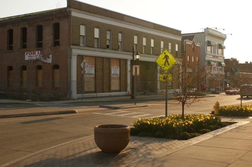
7 Creating a Walkable Portville: Through Complete Streets Portville, New York May 25, 2011 Missing attractive gateway entering village currently only a highway sign exists Brooklyn Street and Fairview Street Wide turning radius onto Fairview from Brooklyn Crosswalk on Brooklyn is faded Truncated domes for ADA accessibility are in place Limited sidewalk along Fairview Street on one side Section with sidewalk has overgrown shrubs There are no curbs along Fairview providing a distinct edge along the street. This situation is allowing cars to park indiscriminately further reducing the limited area for pedestrian access. Fairview takes a 90 degree turn at Foot Bridge over creek Dyke continues along both sides of creek


8 Creating a Walkable Portville: Through Complete Streets Portville, New York May 25, 2011 Temple Street at Depot Street Railroad creates steep pedestrian grade Sidewalk ends along one side of street Sidewalk along non-truck side of Depot Street lacks any type of buffer or curbing Maple Street has excellent sidewalk along one side Missing on the opposite side Sidewalk network ends at village/ town border Main Street at Maple Street Beautiful Pioneer Park Pathways from park end at road Entrances are wide could use bollards to restrict vehicle access Good sidewalks along Main Street on both sides Bicycle lanes and signage are in place (Bike Route 17) Need connection from the rest of the village to the bicycle facilities Excellent ladder bar crosswalks are in place Truncated domes are present at curb ramps but are in need of maintenance

9 Creating a Walkable Portville: Through Complete Streets Portville, New York May 25, 2011 Main Street at Temple Street Signalized intersection with good pedestrian crossings coupled with ADA compliant curb ramps Should be available along both sides Village is currently working on their comprehensive plan update Opportunity to develop complete streets language to establish goals and objectives for enhancing the walkability and bikeability of the village General Recommendations: Develop sidewalk inventory and priority matrix Provide bicycle parking in village Develop bicycle connectivity to Main Street and other transportation generators
10 Creating a Walkable Portville: Through Complete Streets Portville, New York May 25, 2011 Appendices
11

12 Creating a Walkable Portville Through Complete Streets Justin S. Booth, Green Options Buffalo Joshua Poppel, NY Bicycling Coalition/Alta Planning & Design
13 Agenda A Complete Street Visioning Why? Creative Solutions Policy Resources Walkabout De-brief Next Steps

14 What is a Complete Street? A Complete Street is safe, comfortable and convenient for travel via automobile, foot, bicycle, and transit.

15 A Complete Street: Offers a full range of travel choices Connects to a network that offers choices Is fully accessible to all: kids, seniors and people with disabilities Supports & contributes to life in pleasant, convenient neighborhoods

16 Why do we need to Complete the Streets? 52% of Americans want to bike more than they do now. 55% of Americans would prefer to drive less and walk more America Bikes & STPP Poll

17 Fewer kids are biking and walking More parents are driving 2001: 15% walked 1969: 48% walked (EPA, 2003)

18 It s not just distance Students who live within 1 mile and walk or bike: 1999: 31% 1969: 90% (EPA, 2003)

19 Our Current Behavior Of all trips taken in metro areas: 50% 28% are three miles or less are one mile or less 65% of trips under one mile are now taken by automobile 2001 NHTS

20 The Transportation Prescription Research shows that when properly designed, transportation systems can provide: reduce air pollution exercise opportunities improve safety lower emotional stress link poor people to opportunity connect isolated older adults and people with disabilities to crucial services and social supports stimulate economic development

21 Climate Change is A Public Health Concern Direct effects of heat, Health effects related to extreme weather events, Air pollution-related health effects, Water- and food-borne infectious diseases, Vector-borne and zoonotic diseases, and Other pathogens sensitive to weather conditions.

22 Physical Activity The NYS state comptroller has identified the cost of childhood obesity to be $242 million dollars annually in associated medical costs for adults this jumps to $6.1 billion.
23 Fatalities based on speed of vehicle A pedestrian s chance of death if hit by a motor vehicle 100% 90% 80% 70% 60% 50% 40% 30% 20% No Injury 10% Injury Killing Speed and Saving Lives, UK Department of Transportation 0% 20 mph 30 mph 40 mph Death

24 The Cost of Busing in New York State 2,598,035 students are transported to and from school through public expense (77.4% of students in K-12). Total cost of busing in New York State is approximately $1.1 Billion. ($1,147,993,725) If we can increase the number of kids walking and bicycling to school in New York by 5% (129,901 students) we could save $57 million ($57,399,354) each year on busing expenses. Source: School Transportation News updated 1/19/05 (

25 CREATIVE ENGINEERING SOLUTIONS
26 Engineering Strategies 1. Focus first on easy-to-implement and low-cost solutions 2. Match the treatment to the type of problem

27 Focus on low cost, easy to implement solutions Signs Paint Ramps


28 Crosswalk signs and advance warning signs


29 In-street signing


30 Other Signage Flashing speed limit sign Overhead signs/beacons


31 Install high-visibility markings Ladder-style is easier to see.


32 Pavement legends
33 Engineering topic outline Sidewalks Crossings Pathways ADA accessibility On-street bicycling Pedestrian and bicycle bridges Traffic Calming


34 Walkways and crossings: Prerequisites for walking Recommended minimum: 5 Preferred min: 6 At schools and other heavily traveled destination: 8-10


35 Sidewalk design criteria Splash zone 5 to 6 Connect all sidewalks Accommodate pedestrian desire lines outside of splash zones


36 Provide sidewalk buffers

37 No sidewalk buffer


38 Remove obstacles from sidewalks

39 Limit driveway crossings

40 Build driveways like driveways


41 Meet ADA requirements for universal design It s about all of us

42 Wide, multi-lane roads are barriers to walking and bicycling

43 Principles for creating safe crossings Reduce crossing distances Use appropriate traffic controls Marked crosswalks Warning signs or flashers Stop signs and traffic signals Slow vehicle speeds


44 Curb extensions along the route Shorten exposure time with curb extensions and improve visibility, especially children


45 Crossing islands

46 Modify traffic signal phasing and/or timing

47 Pedestrian pushbuttons Buttons may be needed at some crossings Signals can be put in pedestrian recall for key times of day


48 Traffic Signals No right-turn-on-red Countdown signals

49 Bicycle facilities Local and city streets Bike lanes Sharrows Shoulders


50 Bicycle lanes
51 Sharrows


52 Shoulders benefit cyclists and motorists

53 Install bicycle racks


54 Signalized intersections


55 Multi-use paths 10 to 14 wide, 5 setback

56 Traffic calming

57 Slowing down traffic

58 Slowing down traffic


59 Correct design invites correct use Which street has lower speeds?

60 Narrow lanes reduce speeds Use paint to reduce lane width

61 Raised pedestrian crosswalks

62 Effect of large radius on drivers They drive fast

63 Curb radii: Keeping it tight

64 Road diet Watch it happen

65 Road diet Watch it happen

66 Road diet Watch it happen


67 FHWA references Crosswalk Study Pedestrian Facilities Users Guide Sidewalk Study
68 PED SAFE
69 Summary 1. Focus first on easy-to-implement and lowcost solutions 2. Also identify and program longer-term improvement needs (e.g. sidewalks) 3. Match the treatment to the type of problem
70 Summary 4. Provide and maintain a complete network of facilities: Sidewalks On-street bicycle facilities Paths Connections Pedestrian and bicycle bridges
71 Summary 5. Provide safe street crossings: Keep it simple Shorten crossing distances Carefully select crossing locations and marked crosswalks Create visible crossings 6. Slow down traffic speeds
72 POLICY

73 Policy Complete Streets Advisory Board Complete Streets Coordinator Complete Streets Ordinance Bicycle Parking Ordinance Street Design Guidelines Comprehensive Plan Land Use Plan Zoning Code Sidewalk Snow Removal Public Art

74 Implementation

75 Overcoming Challenges in Local Communities
76 For More Information: Justin S. Booth Or Joshua Poppel


77
 and must meet the following requirements: No tree to be planted when there is less then 3")
78 Trees: Site Selection New trees should be included in every public streetscape improvement or new development. Tree lawns are suitable planting sites in the area between the sidewalk and the curb (snow storage area) and must meet the following requirements: No tree to be planted when there is less then 3 between the sidewalk and curb 35 spacing from an intersection or stop sign 6 spacing between a driveway and drip line of overhanging tree 5 spacing from underground service or utility box 15 spacing from a street light, utility pole or fire hydrant 40 spacing between large trees, 20 for medium trees, 20 for small trees as designated under the City of Buffalo Reforestation Master Plan species selection list. Tree pits are suitable planting sites in concrete cut out areas which must meet the minimum requirements for sites in tree lawns as well as: No vaults or utility services are directly under site where concrete is to be cut 5 clearance for pedestrian walkway next to pit Not to be located under any overhanging structures Size of cut out must have 28 square feet of surface area, such as 6 x6, 5 x6 or 4 x7, unless structural soil is used, then surface area may decrease to 20 square feet, 4 x 5 No tree grates are to be placed after planting Planter boxes are suitable planting sites when tree lawns and tree pits are not possible. Planter boxes must meet the minimum requirements for tree lawns as well as: Planter box should be placed 18 inches from curb line No less than 16 square feet of surface area (4 x4 ) for small trees and shrub-like trees No less than 9 feet of surface area (3 x3 ) for small shrubs 5 of clearance for pedestrian walkway next to planter box Not to be located under any overhanging structures Must be irrigated regularly to ensure survival of plant

79 Trees: Maintenance Trees often ruin sidewalks, and sidewalk repair often kills trees. This conflict comes from the fact that sidewalks and trees have competing needs. Trees need a soil that is moist and loose, and that they can push aside as they grow. Sidewalks should be constructed on a dense soil that will not shift with a load. Most of the damage to sidewalks is caused as roots become thicker, lifting up the concrete slabs. To prevent extensive sidewalk damage, the appropriate rootstocks should be chosen for the trees planted at each location. Trees and rootstocks that have extensive, shallow root systems should not be planted adjacent to sidewalks. Also, tree selection should be made based on the available soil, water and light conditions, and most importantly, the width of the planting strip. Where mature trees are in place, root barriers, root pruning techniques, and interlocking sidewalk pavers could be used to retain as many mature trees as possible. The paving blocks can also be set in sand and not mortared together. The City of Buffalo has established the Approved Street Tree Planting List which has over fifty acceptable species of trees with descriptions such as size, condition, form, method and season for planting each one. Source: Dodge, Linda and Jim Geiger (2001). Tree Roots and Sidewalk Damage. City Trees, The Journal of The Society of Municipal Arborists, Vol 37, Number 4 City of Buffalo Department of Public Works, Parks and Streets; Bureau of Forestry (2004) Arboricultural Standards Manual
80 Resources Active Transportation is a Web resource for making walking and bicycling a part of daily transportation. Adventure Cycling is working to inspire people of all ages to travel by bike. Alliance for Biking and Walking is a coalition of state and local bicycle and pedestrian groups throughout the United States. Alliance for Biking and Walking groups will be key partners for implementation of Safe Routes to School programs. Locate a group in your community to find out more information regarding how they are working on Safe Routes to School. America Bikes is a coalition of national bicyle and pedestrian organizations. America Bikes took the lead on advocating for Safe Routes to School in the federeal transportation bill. America Walks is a national coalition of walking advocates that includes a list of member groups. Association of Pedestrian and Bicycle Professionals is a professional membership organization for people who specialize in improving conditions for walking and bicycling. Bikes Belong Coalition is the national coalition of bicycle suppliers and retailers working to put more people on bicycles more often. Bikes Belong Coalition is currently funding the Safe Routes to School National Partnership. Complete Streets Coalition advocates for streets to be designed and operated to enable safe access for all users. Pedestrians, bicyclists, motorists, and bus riders of all ages and abilities are able to safely move along and across a complete street. Healthy Schools Program offers real tools and solutions for schools to become healthier places that promote physical activity and healthy eating. Visit their website for more information on their best-practice program that provides schools with on-site and online technical assistance, resources, and national awards for school-based efforts to create healthier school environments. International Mountain Bicycling Association is dedicated to preserving and expanding trails for mountain biking. IMBA has programs for kids. League of American Bicyclists (LAB) is developing education materials and a curriculum for bicycle safety. LAB also has a training program for teaching adults how to ride bicycles safely. National Center for Bicycling and Walking provides excellent Safe Routes to School resources that include a wide array of materials and links, including technical
81 assistance, vision and goals, sample press releases, and more. National Center for Safe Routes to School offers a centralized resource of information on how to start and sustain a Safe Routes to School program, case studies of successful programs, as well as other resources for training and technical assistance. Pedestrian and Bicycle Information Center developed a Safe Routes to School National Course designed to help communities create sound programs that are based on community conditions, best practices, and the responsible use of resources. Rails-to-Trails Conservancy provides resources for turning abandoned railroad right-ofways into bicycle and pedestrian trails for community and school use. Safe Routes to School National Partnership is a network of more then 400 nonprofit organizations, government agencies, schools and professionals working together to advance the Safe Routes to School (SRTS) movement in the United States. Surface Transportation Pilot Project is a diverse, nationwide coalition working to ensure safer communities and smarter transportation choices. This link directs you to a 2002 summary of Safe Routes to School programs throughout the United States. Walkable Communities helps whole communities become more pedestrian friendly.
REGIONAL BICYCLE AND PEDESTRIAN DESIGN GUIDELINES
 REGIONAL BICYCLE AND PEDESTRIAN DESIGN GUIDELINES November 16, 2011 Deb Humphreys North Central Texas Council of Governments Bicycle and Pedestrian Advisory Committee Snapshot of the Guide 1. Introduction
APPENDIX A: Complete Streets Checklist DRAFT NOVEMBER 2016
 APPENDIX A: Complete Streets Checklist DRAFT NOVEMBER 2016 Complete Streets Checklist MetroPlan Orlando s Complete Streets Checklist is an internal planning tool for staff to further implementation of
Perryville TOD and Greenway Plan
 Perryville TOD and Greenway Plan Greenway Glossary Pathway: A bicycle and pedestrian path separated from motorized vehicular traffic by an open space, barrier or curb. Multi-use paths may be within the
and older adults and people with disabilities still face barriers when using the pedestrian network and public transportation.
 Background Afterthe1980Olympics,theLakePlacid/NorthElbacommunityadoptedaneconomicstrategy ofdevelopingandmarketingeventstoincreaseareatourism.thisstrategyhasbeenvery successful.overrecentyearsthevolumeofvisitorshasincreased,andthelengthofthe
Living Streets Policy
 Living Streets Policy Introduction Living streets balance the needs of motorists, bicyclists, pedestrians and transit riders in ways that promote safety and convenience, enhance community identity, create
NJDOT Complete Streets Checklist
 Background The New Jersey Department of Transportation s Complete Streets Policy promotes a comprehensive, integrated, connected multi-modal network by providing connections to bicycling and walking trip
What Is a Complete Street?
 Session 5 Charleen Zimmer, AICP, Zan Associates May 5-7, 2010 What Is a Complete Street? May 2010 5-1 Not a Complete Street More of a Complete Street May 2010 5-2 Benefits of Complete Streets Safety for
Broad Street Bicycle Boulevard Design Guidelines
 Broad Street Bicycle Boulevard Design Guidelines Building from the strategies introduced in the 2013 Bicycle Transportation Plan and community input received thus far, City Transportation Staff have identified
Active Transportation Facility Glossary
 Active Transportation Facility Glossary This document defines different active transportation facilities and suggests appropriate corridor types. Click on a facility type to jump to its definition. Bike
Bicycle and Pedestrian Connectivity Study. Old Colony Planning Council
 Bicycle and Pedestrian Connectivity Study Old Colony Planning Council Outline Why consider bike/peds in road designs? Why are measures needed? Connecting Land Use with Transportation Evaluation Tools:
Watertown Complete Streets Prioritization Plan. Public Meeting #1 December 14, 2017
 Watertown Complete Streets Prioritization Plan Public Meeting #1 December 14, 2017 Goals for Public Meeting Overview of MassDOT Complete Streets Funding Program Educate the community on Complete Streets
Bicycle Facilities Planning
 Bicycle Facilities Planning Overview Types of Cyclists Purpose for Riding Types of Facilities Bike Lanes Bicycle Boulevards Cycle Tracks Intersections Signals Signing and Marking Discussion Types of Bicyclists
TOWN OF PORTLAND, CONNECTICUT COMPLETE STREETS POLICY
 TOWN OF PORTLAND, CONNECTICUT COMPLETE STREETS POLICY I. VISION, GOALS & PRINCIPLES VISION To improve the streets of Portland making them safer and more accessible for all users including pedestrians,
Chapter 5. Complete Streets and Walkable Communities.
 Chapter 5. Complete Streets and Walkable Communities. 5.1 Description of Complete Streets. Cities throughout the world, and specifically the United States, are coming to embrace a new transportation and
Complete Streets. Designing Streets for Everyone. Sarnia
 Complete Streets Designing Streets for Everyone Sarnia Complete Streets ~ Sarnia ~ 2018 Introduction Our City is made up of a network of streets that we use to go for a walk, cycle to work, drive to the
MAG Town of Cave Creek Bike Study Task 6 Executive Summary and Regional Significance Report
 Page 1 MAG Town of Cave Creek Bike Study Task 6 Executive Summary and Regional Significance Report August 1, 2012 MAG Project #481 Page 2 Task 6 Executive Summary and Regional Significance Report Introduction
Transportation Planning Division
 Transportation Planning Division Presentation Outline Study Tasks Recap of Previous Meetings Data Collected Focus Areas within Study Limits Design Principles Tool Box Recommended Concepts Schedule Moving
Steps to Conducting a Complete Streets Assessment
 Steps to Conducting a Complete Streets Assessment Familiarize yourself with Complete Streets Read through the Complete Streets Assessment Guidelines. This will give you an idea of what Complete Streets
CONNECTING PEOPLE TO PLACES
 CONNECTING PEOPLE TO PLACES 82 EAST BENCH MASTER PLAN 07 Introduction The East Bench transportation system is a collection of slow moving, treelined residential streets and major arteries that are the
Safe Routes to School Action Plan Aberdeen, Idaho
 Background Aberdeen, Idaho is a largely agricultural community of nearly 2,000 people and is located in the southeast portion of the state on the western edge of American Falls Reservoir. The community
Cycle Track Design Best Practices Cycle Track Sections
 Design Best Practices Sections It is along street segments where the separation and protection methods of cycle tracks offer more comfort than conventional bicycle lanes, and are more attractive to a wide
G AT E WAY PLAN. Community BRIEFING KIT GATEWAY BIKE
 G AT E WAY PLAN GATEWAY BIKE Community BRIEFING KIT PLAN August 2016 TABLE OF CONTENTS INTRODUCTION... 1 THE BENEFITS OF A BIKEABLE COMMUNITY... 2 ECONOMY...2 SAFETY...3 HEALTH...3 HOUSEHOLD SPENDING...3
Chapter 4 TOOLBOX AND SAMPLE BIKE BOULEVARD LAYOUT
 Chapter 4 TOOLBOX AND SAMPLE BIKE BOULEVARD LAYOUT OVERVIEW This chapter describes a cohesive set of strategies to create a bicycle boulevard, namely to make streets safer and more efficient for bicycle
City of Birmingham Draft Multi-modal Transportation Plan
 City of Birmingham Draft Multi-modal Transportation Plan City Commission Public Hearing Monday, November 25, 2013 7:30 pm Norman Cox, PLA, ASLA The Greenway Collaborative, Inc. Ann Arbor, Michigan The
Item to be Addressed Checklist Consideration YES NO N/A Required Description Complete Streets Guidelines
 Passaic County Complete Streets Checklist - Concept Development Project Name Item to be Addressed Checklist Consideration YES NO N/A Required Description Complete Streets Guidelines Existing Plans Have
Corpus Christi Metropolitan Transportation Plan Fiscal Year Introduction:
 Introduction: The Safe, Accountable, Flexible, Efficient Transportation Equity Act: A Legacy for Users (SAFETEA-LU) has continued the efforts started through the Intermodal Surface Transportation Efficiency
Introduction. Who is WILMAPCO. Why are walkable communities important
 Walkable Community Workshops Round 1 April 2005 SPONSORED BY WILMAPCO AND CCOBH CITY OF NEW CASTLE EDGEMOOR GARDENS CIVIC ASSOCIATION WITH FUNDING BY DELAWARE DEPARTMENT OF TRANSPORTATION AND THE DELAWARE
Bicycle and Pedestrian Advisory Committee (BPAC) November 21, 2013
 November 21, 2013") Bicycle and Pedestrian Advisory Committee (BPAC) November 21, 2013 OVERALL LAND USE CONCEPT Overall Broadway Valdez District: 95.5 acres (35.1 acres right-of ways + 60.4 acres developable land) Plan Subareas:
Bicycle and Pedestrian Advisory Committee (BPAC) November 21, 2013 OVERALL LAND USE CONCEPT Overall Broadway Valdez District: 95.5 acres (35.1 acres right-of ways + 60.4 acres developable land) Plan Subareas:
CONNECTIVITY PLAN. Adopted December 5, 2017 City of Virginia Beach
 CONNECTIVITY PLAN Adopted December 5, 2017 City of Virginia Beach CONTENTS 1.0 Background & Purpose... 2 2.0 Existing Inventory & Analysis... 3 ViBe District Existing Walking Conditions... 4 3.0 ViBe District
5. RUNNINGWAY GUIDELINES
 5. RUNNINGWAY GUIDELINES These guidelines should be considered collectively when making runningway decisions. A runningway is the linear component of the transit system that forms the right-of-way reserved
CURBSIDE ACTIVITY DESIGN
 5 CURBSIDE ACTIVITY DESIGN This chapter provides design guidance for separated bike lanes adjacent to curbside activities including parking, loading and bus stops. Typical configurations are presented
Creating walkable, bikeable and transit-supportive communities in Halton
 Creating walkable, bikeable and transit-supportive communities in Halton By presenting current research and best practices, the information in this paper is meant to support and broaden discussion on how
Proposed. City of Grand Junction Complete Streets Policy. Exhibit 10
 Proposed City of Grand Junction Complete Streets Policy Exhibit 10 1 City of Grand Junction Complete Streets Policy Vision: The Complete Streets Vision is to develop a safe, efficient, and reliable travel
North Avenue Corridor Study
 North Avenue Corridor Study City Council October 6, 2014 Presentation Outline Project Initiation & Process Corridor Conditions & Issues Vision & Goals Concept Development - Development/Evaluation Implementation
BIKE PLAN CONTENTS GATEWAY
 CONTENTS Acknowledgments...vii Great Rivers Greenway District Board of Directors... vii Great Rivers Greenway District Staff... vii Project Consultants... vii Committees... viii Citizens Advisory Committee
INDOT Complete Streets Guideline & Policy
 INDOT Complete Streets Guideline & Policy INTRODUCTION The Complete Streets guidelines build upon multiple efforts and promote a multimodal transportation system that is integrated and sustains land use
Improvements Infrastructure Gap Assessment and Improvements Street Striping
 Infrastructure Project Proposal The federal-aid Safe Routes to School program funds infrastructure/engineering projects that fall into two categories: Design (available only to School Development Authority
North Avenue Corridor Study
 North Avenue Corridor Study Transportation, Energy and Utilities Committee September 10, 2014 Presentation Outline Project Initiation: Why North Avenue? Existing Conditions + Issues Vision + Goals Improvement
STEERING COMMITTEE MEETING June 17, Streetscape Overview Burlington Comprehensive Master Plan
 STEERING COMMITTEE MEETING June 17, 2015 Streetscape Overview Burlington Comprehensive Master Plan 1 Introduction Slide This slide show was presented to the Burlington Steering Committee on June 17, 2015
Chapter 6: Along the Street
 Chapter 6: Along the Street This section describes the types of infrastructure that should be in place along school routes to make walking and bicycling to school safer. Sidewalks In communities with sidewalks,
Complete Streets 101: The Basics
 Complete Streets 101: The Basics Michigan Municipal League - Capital Conference March 21, 2017 Chip Smith, AICP - Senior Planner - Wade Trim Inc. and City Council member City of Ann Arbor 2017 MML Capital
TLC GRANT K / WATER STREETSCAPE ENHANCEMENTS WILL HANDSFIELD, AICP TRANSPORTATION DIR, GEORGETOWN BID
 TLC GRANT K / WATER STREETSCAPE ENHANCEMENTS Applied Fall 15 Awarded Winter 15/ 16 Notice to Proceed Spring 16 Completion Summer 16 Community Outreach Ongoing WILL HANDSFIELD, AICP TRANSPORTATION DIR,
Vision: Traditional hamlet with an attractive business/pedestrian friendly main street connected to adjacent walkable neighborhoods
 N D. Focus Area II Vision: Traditional hamlet with an attractive business/pedestrian friendly main street connected to adjacent walkable neighborhoods Transit Road Focus Area II is located in the Hamlet
Bridgewater Complete Streets Prioritization Plan and Pedestrian Safety Assessment
 Bridgewater Complete Streets Prioritization Plan and Pedestrian Safety Assessment Presented by Luciano Rabito Manager of Complete Streets Presented to Bridgewater, MA Wednesday, April 26, 2017 6:30 P.M.
IBI Group November 5, 2012
 IBI Group Agenda Session 1 3:00 PM Welcome / Sign in 3:10 PM Presentation 3:30 PM Questions? 3:35 PM World Café Discussion 4:45 PM Report on top 3 ideas 4:50 PM Next Steps 5:00 PM Adjourn 2 Agenda Session
RESOLUTION NO ?? A RESOLUTION OF THE CITY OF NEPTUNE BEACH ADOPTING A COMPLETE STREETS POLICY
 RESOLUTION NO. 2018-?? A RESOLUTION OF THE CITY OF NEPTUNE BEACH ADOPTING A COMPLETE STREETS POLICY WHEREAS, safe, convenient, and accessible transportation for all users is a priority of the City of Neptune
Agenda. Overview PRINCE GEORGE S PLAZA METRO AREA PEDESTRIAN PLAN
 PRINCE GEORGE S PLAZA METRO AREA PEDESTRIAN PLAN May 28, 2008 Agenda Welcome and introductions Project overview and issue identification Planning context and strengths Design challenges and initial recommendations
COWETA HIGH SCHOOL AND EAST HIGHWAY 51
 COWETA HIGH SCHOOL AND EAST HIGHWAY 51 Lack of sidewalks along Ben Lumpkin Rd. Lack of crosswalks and ramps at intersection. Hwy 51 is wide to cross as a pedestrian. No ADA compliance or connection to
Appendix T CCMP TRAIL TRAFFIC & TRANSPORTATION DESIGN STANDARD
 Appendix T CCMP 3.3.4 TRAIL TRAFFIC & TRANSPORTATION DESIGN STANDARD 3.3.4 Trail Traffic and Transportation Design Multi-use trails have certain design standards, which vary depending on the agency that
2.0 Existing Conditions
 20 2.0 Existing Conditions 2.1 Land Use, Future Growth Patterns, Physical Barriers Geographic Overview Sutter County s land use pattern is characterized by extensive agricultural areas, significant natural
Streets. Safe for Pedestrians 20% 2nd 5,000. Are We People-Friendly?
 Streets Safe for Pedestrians 20% Pedestrian deaths account for more than of all traffic-related fatalities in California each year. 600 More than people are killed and another 13,000 are injured every
EXECUTIVE SUMMARY. Vision
 Vision Walking and bicycling in Salt Lake City will be safe, convenient, comfortable, and viable transportation options that connect people to places, foster recreational and economic development opportunities,
Chapter 3 DESIGN SPECIFICATIONS
 Brampton PathWays Planning and Design Guidelines 27 Chapter 3 DESIGN SPECIFICATIONS 3.1 CLASS 1 MULTI-USE PATH Off-road multi-use trails are the backbone of the Brampton PathWays Network. They are typically
DRAFT MOVING FORWARD RHODE ISLAND BICYCLE MOBILITY PLAN 2018 PREPARED FOR PREPARED BY IN ASSOCIATION WITH
 RHODE ISLAND MOVING FORWARD BICYCLE MOBILITY PLAN 2018 PREPARED FOR PREPARED BY IN ASSOCIATION WITH T AF CHAPTER 1 D R INTRODUCTION CHAPTER 3 ARTICULATES VISION Bicycling is safe, fun and practical in
CHAPTER 3: Vision Statement and Goals
 Davidson Walks & Rolls: Active Transportation Master Plan CHAPTER 3 Contents: Overview Vision Statement Measurable Goals Public Outreach CHAPTER 3: Vision Statement and Goals Overview The vision statement
Bikeway action plan. Bicycle Friendly Community Workshop March 5, 2007 Rochester, MN
 Bikeway action plan Summary The was held on March 5, 2007 at the Rochester Mayo Civic Center. The workshop was hosted by Rochester-Olmsted County Planning Department in collaboration with the League of
Pedestrian, Bicycle and Traffic Calming Strategic Implementation Plan. January 18, 2011
 Pedestrian, Bicycle and Traffic Calming Strategic Implementation Plan January 18, 2011 Tonight s Agenda Receive update on project Provide feedback on two policy issues Complete Streets Policy Project Prioritization
Chapter 2: Standards for Access, Non-Motorized, and Transit
 Standards for Access, Non-Motorized, and Transit Chapter 2: Standards for Access, Non-Motorized, and Transit The Washtenaw County Access Management Plan was developed based on the analysis of existing
TOWN OF WILLIAMSTON, SC BICYCLE AND PEDESTRIAN MASTER PLAN TOWN OF WILLIAMSTON, SC BICYCLE AND PEDESTRIAN MASTER PLAN
 TOWN OF WILLIAMSTON, SC BICYCLE AND PEDESTRIAN MASTER PLAN Americans Want Choices 55% of Americans would rather drive less & walk more. Transit use is growing faster than population or highway travel.
MASTER BICYCLE AND PEDESTRIAN PLAN
 VILLAGE OF NORTHBROOK MASTER BICYCLE AND PEDESTRIAN PLAN DRAFT PLAN OPEN HOUSE May 2, 2018 AGENDA 1. Community Engagement 2. Vision and Goals 3. General Structure of Plan 4. Recommendations Overview 5.
Memo. Introduction. Memphis STP Pedestrian Sidewalk Project
 Memo Memphis STP Pedestrian Sidewalk Project To: Kyle Wagenshutz, City of Memphis From: Matthew Berkow, Collin Chesston, and Anne Eshleman, Alta Planning + Design Date: June 2014 Re: Photo Inventory Introduction
PRINCE GEORGE S PLAZA METRO AREA PEDESTRIAN PLAN
 PRINCE GEORGE S PLAZA METRO AREA PEDESTRIAN PLAN May 28, 2008 Agenda Welcome and introductions Project overview and issue identification Planning context and strengths Design challenges and initial recommendations
Figure 4-10: Pedestrian Improvements Types of Potential Station Area Improvements - Place-Making Improvements
 INCORPORATE FEATURE PAVIN IN CROSSWALK AND INTERSECTION FIELDS Identifies high-priority pedestrian areas and create a station identity through colorful and interesting patterns ADD CURB EXTENSIONS Extending
ACTIVE TRANSPORTATION
 ACTIVE TRANSPORTATION Mobility 2040 Supported Goals Improve the availability of transportation options for people and goods. Support travel efficiency measures and system enhancements targeted at congestion
Michael Parmer, Management Aide, City Manager's Office
 P139 STAFF REPORT f CITY NL- NAGER' S OFFICE RANCHO Date: C;UCAMONGA To: From: Subject: Mayor and Members of the City Council John R. Gillison, City Manager Michael Parmer, Management Aide, City Manager's
AMATS Complete Streets Policy
 AMATS Complete Streets Policy Table of Contents: Section 1. Definition of Complete Streets Section 2. Principles of Complete Streets Section 3. Complete Streets Policy Section 4. Consistency Section 5.
Who is Toole Design Group?
 2018 AASHTO Bike Guide Status Update NCHRP 15 60 Amalia Leighton Cody, PE, AICP & Kenneth Loen, PE Washington APWA October 4, 2018 Who is Toole Design Group? TDG is a full service engineering, planning
City of Wilsonville 5 th Street to Kinsman Road Extension Project
 City of Wilsonville 5 th Street to Kinsman Road Walking Tour & Neighborhood Workshop Summary Report Public Outreach Overview On July 18 th, 2017, the City of Wilsonville hosted a neighborhood walking tour
About the Studio. Edward J. Bloustein School of Planning and Public Policy - Rutgers University
 About the Studio Edward J. Bloustein School of Planning and Public Policy - Rutgers University Purpose of studio: Help City of Bayonne apply for Safe Routes to School (SRTS) funding by producing a School
Appendix 3 Roadway and Bike/Ped Design Standards
 Appendix 3 Roadway and Bike/Ped Design Standards OTO Transportation Plan 2040 4/20/2017 Page A3-1 Adopted Standards The adopted OTO Design Standards and Major Thoroughfare Plan are contained herein.
LANCASTER CITY BICYCLE NETWORK
 LANCASTER CITY BICYCLE NETWORK Downtown Merchants Meeting Wednesday, July 19, 2017 http://www.lancasteratp. DOWNTOWN WALKABILITY ANALYSIS What changes can be made, in the least amount of time, and for
Chapter 5: Crossing the Street
 Chapter 5: Crossing the Street Whether walking or bicycling, a student s journey to school will more than likely require crossing one or more streets. Per the Safe Routes to School Guide, maintained by
Zlatko Krstulich, P.Eng. City of O9awa
 Zlatko Krstulich, P.Eng. City of O9awa 1. Introduction to the Ontario Traffic Manual Series 2. What is OTM Book 18: Bicycle Facilities? 3. Study / Committee Team Members 4. Brief overview of the content
CITY OF BLOOMINGTON COMPLETE STREETS POLICY
 CITY OF BLOOMINGTON COMPLETE STREETS POLICY POLICY OBJECTIVE: The City of Bloomington will enhance safety, mobility, accessibility and convenience for transportation network users of all ages and abilities,
NON-MOTORIZED TRANSPORTATION
 NON-MOTORIZED TRANSPORTATION This chapter discusses bicycle and pedestrian initiatives, non-motorized goals and objectives, safety, education, and regional enforcement efforts, key area infrastructure,
Non-Motorized Transportation 7-1
 Non-Motorized Transportation 7-1 Transportation facilities no longer mean just accommodating a vehicle powered by a combustion engine. Pedestrian and non-motorized facilities are important modes of travel
NM-POLICY 1: Improve service levels, participation, and options for non-motorized transportation modes throughout the County.
 Transportation PRINCE WILLIAM COUNTY 2008 COMPREHENSIVE PLAN NON-MOTORIZED PLAN CONTENTS Goals, Policies, and Action Strategies Table 4 (Bike Facility Classifications and Descriptions) Table 5 (Bike Facility
Complete Streets Policy and Practice
 Complete Streets Policy and Practice presented by Leslie Phemister, Nancy Wagner and Kasey Holloway Active Transportation Alliance 1 Learning Objectives Understand the connection between public health
Cyclists and Bikeways: What s your match? A guide to bikeway options for a variety of cyclists
 Cyclists and Bikeways: What s your match? guide to bikeway options for a variety of cyclists The workshop and this resource were made possible by funding from the Province of Ontario via the Ministry of
Highway School, Ithaca NY
 Highway School, Ithaca NY June 1, 2009 Michael Ronkin Designing Streets for Pedestrians and Bicyclists 1 We know how to build right 6 Yet many roads are built like this 7 What is a Complete Street?
Bicycle + Pedestrian Connectivity Gap Analysis
 Accelerated Bridge Program Bicycle + Pedestrian Connectivity Gap Analysis Tuesday, October 11 Shriners Hospital, Boston 6:30-8:00 PM Thursday, October 13 Community Rowing, Brighton 6:30-8:00 PM Tuesday,
Appendix C. TRAFFIC CALMING PROGRAM TOOLBOX
 Appendix C. TRAFFIC CALMING PROGRAM TOOLBOX PHASE I...2 Do Not Enter Sign...3 One-Way Sign...4 Turn Prohibition...5 Pavement Markings...6 Speed Monitoring Trailer...7 Neighborhood Speed Watch...8 Police
Complete Streets: Building Momentum in Connecticut
 Complete Streets: Building Momentum in Connecticut Tri-State Transportation Campaign, 2012 What are Complete Streets? Complete Streets are safe, comfortable, and convenient for travel for everyone, regardless
Pedestrian Safety: A Federal Perspective. Emmett McDevitt Transportation Safety Engineer September 28, 2010
 Pedestrian Safety: A Federal Perspective Emmett McDevitt Transportation Safety Engineer September 28, 2010 Pedestrian Fatalities by Year in US (1997-2009) 6,000 5,000 4,000 3,000 2,000 1,000 0 1997 1998
Off-road Trails. Guidance
 Off-road Trails Off-road trails are shared use paths located on an independent alignment that provide two-way travel for people walking, bicycling, and other non-motorized users. Trails specifically along
Walkable Community Workshops
 Presented by: Larry McAuliffe Manager, Research Unit, Planning Division New York Metropolitan Transportation Council NYSMPO Conference 2008 Walkable Community Workshops Discussion Topics: I. NYMTC in the
Prince George s County plans, policies, and projects
 Prince George s County plans, policies, and projects Over 250 projects for trails, bikeways, designated bike lanes and sidewalk construction Trail projects that improve access to Metro Sidewalk and trail
Active Transportation Rail to River Corridor. Community Meeting - Segment A
 Active Transportation Rail to River Corridor Community Meeting - Segment A June 29, 2017 Tonight s Agenda > Open House (30 min) > Welcome / Project Overview > Presentation of 30% Design Refinements > Next
5 CIRCULATION AND STREET DESIGN
 5 CIRCULATION AND STREET DESIGN This chapter describes circulation and streetscape improvements proposed for the Northwest Chico Specific Plan Area. It includes detailed design specifications for existing
Chapter 2. Bellingham Bicycle Master Plan Chapter 2: Policies and Actions
 Chapter 2 Bellingham Bicycle Master Plan Chapter 2: Policies and Actions Chapter 2: Policies and Actions The Bicycle Master Plan provides a road map for making bicycling in Bellingham a viable transportation
Bicycle and Pedestrian Chapter TPP Update Overview. TAB September 20, 2017
 Bicycle and Pedestrian Chapter TPP Update Overview TAB September 20, 2017 Bicycling & Walking in the Twin Cities Where are we now? The Bike-Pedestrian system Current trends New developments Where are we
City of Charlottesville Bicycle and Pedestrian Master Plan Update
 City of Charlottesville Bicycle and Pedestrian Master Plan Update September 17, 2014 I. Welcome and meeting overview II. Project status update III. Network overview IV. Break-out groups Pedestrian Network
City of Novi Non-Motorized Master Plan 2011 Executive Summary
 City of Novi Non-Motorized Master Plan 2011 Executive Summary Prepared by: February 28, 2011 Why Plan? Encouraging healthy, active lifestyles through pathway and sidewalk connectivity has been a focus
10/30/2012 VIA
 10/30/2012 VIA EMAIL David Hung, Associate Planner Community Development Department, Current Planning Division City of Sacramento 300 Richards Blvd., 3 rd Floor Sacramento, CA 95811 RE: The Cannery On-Site
11/3/2014 VIA . WALKSacramento has reviewed the Stockton and T Mixed-Use project at 3675 T Street in the
 11/3/2014 VIA EMAIL Antonio Ablog Planning Department City of Sacramento 300 Richards Boulevard Sacramento, CA 95811 RE: Design Review for Stockton and T Mixed-Use (P14-042) Dear Mr. Ablog: WALKSacramento
Omaha s Complete Streets Policy
 Omaha s Complete Streets Policy (Adopted August 2015) VISION To create great places and enhance our quality of life, the City of Omaha will provide safe, accessible streets for all users. Complete Streets
4. Mobility and Transportation Element. Page Bikes and Pedestrians
 Below are the specific General Plan text changes proposed for A-16-015 and the proposed changes to Figure MT-2 Paths and Trails. In general changes consist of removing references to the Bicycle, Pedestrian
DOWNTOWN MIAMI PEDESTRIAN PRIORITY ZONE
 DOWNTOWN MIAMI PEDESTRIAN PRIORITY ZONE AUGUST 6, 2013 DOWNTOWN MIAMI BY THE NUMBERS more than 200,000 people live, work, and play here every day is home to more than 1,000 events each year hosts more
9/21/2016 VIA . RE: The Knot (DR16-270)
") 9/21/2016 VIA EMAIL Garrett Norman, Assistant Planner City of Sacramento Community Development Department 300 Richards Boulevard, 3 rd Floor Sacramento, CA 95811 RE: The Knot (DR16-270) Dear Mr. Norman:
9/21/2016 VIA EMAIL Garrett Norman, Assistant Planner City of Sacramento Community Development Department 300 Richards Boulevard, 3 rd Floor Sacramento, CA 95811 RE: The Knot (DR16-270) Dear Mr. Norman:
Construction Specifications Manual
 Isle of Wight County Pedestrian and Bicycle Master Plan Construction Specifications Manual Adopted August 20, 2009 Introduction The Isle of Wight County Pedestrian and Bicycle Facilities Master Plan was