North Avenue Corridor Study
|
|
|
- Bathsheba Sutton
- 5 years ago
- Views:
Transcription


1 North Avenue Corridor Study Transportation, Energy and Utilities Committee September 10, 2014
2 Presentation Outline Project Initiation: Why North Avenue? Existing Conditions + Issues Vision + Goals Improvement Options - Development /Evaluation Implementation Plan - Recommended Concepts Action 2

3 Corridor Study Origin 2011 Transportation Plan A shift to a complete streets strategy Burlington s gateway streets must carry all travel modes cars and trucks, buses, bikes, and pedestrians - because no alternatives exist The only essential element of a complete street is accommodating all travel modes safely and efficiently. Implementation through Corridor Studies: Battery Street (preliminary analysis) Colchester Avenue North Avenue Winooski Avenue 5. Battery Street and Shelburne Street TBD 3
4 Corridor Study Process Public Workshop #1 Public Workshop #2 Public Workshop #3 Collect Information & Identify Issues Evaluate Existing and Future Conditions Develop Corridor Vision and Goals Identify Options Evaluate Options Implementation Plan Public Outreach Process Advisory Committee Participants Burlington City Council Burlington School District City of Burlington Departments CCRPC CCTA AARP NPA Reps from Wards 3, 4 and 7 Burlington Partnership for a Healthy Community Local Motion Other Outreach Direct outreach to stakeholders Online input tool Website & comments Heineberg Senior Center JJ Flynn PTO 4
5 Corridor Conditions & Issues

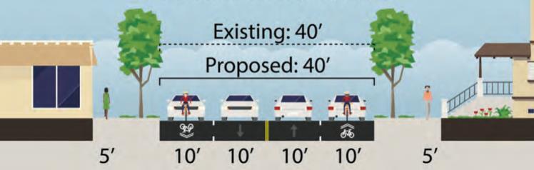
6 Existing Conditions Plattsburg Ave to Shore Rd Shore Rd to VT ROW, but constrained Sidewalks throughout, but poor condition and few crossings Inconsistent bike facilities, limited connections to paths Single family + multi-family + scattered retail + institutions Frequent driveways CCTA Route 7 Unclear parking Skewed intersections, highspeed right turns Washington St to North St Institute Rd to Washington St VT 127 to Institute Rd 6


7 Average Daily Traffic Volumes + Future Growth 10,800 6, % growth + 10% growth 13,700 19,100 7, % growth 12, % growth


8 High Crash Locations ( ) Birch Ct to Woodbury Rd Crashes: 39 PDO: 33 (85%) Crash Rate: 6.48 per MVM Actual/Critical Ratio: 1.23 Severity Index: $21,677 Gosse Ct/Woodlawn Rd to Poirer Pl Crashes: 46 PDO: 42 (91%) Crash Rate: 6.18 per MVM Actual/Critical Ratio: 1.22 Severity Index: $13,100 Lakewood Pkwy to Ethan Allen Pkwy Crashes: 76 PDO: 60 (79%) Crash Rate: per MVM Actual/Critical Ratio: 2.00 Severity Index: $41,204 Strong St/Ward St to Sherman St Crashes: 58 PDO: 4 (93%) Crash Rate: 9.51 per MVM Actual/Critical Ratio: 1.81 Severity Index: $12,107
9 Vision & Goals
10 Vision Statement for North Avenue* North Avenue will continue to serve as the primary transportation corridor connecting Burlington s New North End with the rest of the City. As the North End s Main Street, North Avenue will provide for safe, inviting, and convenient travel for all users of all ages and abilities including motorists, pedestrians, bicyclists, and public transportation riders. The need to move people through the corridor will be balanced with the need to provide access to homes, businesses, and local institutions. The corridor will develop into an attractive public space through creative streetscape, signage, and other site design features. The corridor will become more livable and desirable by promoting social interaction, public health, economic development and environmentally sustainable initiatives. 10 *modified from 2012 EPA s Building Blocks for a Sustainable Community Workshop,Complete Streets Vision for Burlington
11 Major Goals for North Avenue Remake the North Ave corridor into a Complete Street that accommodates the safe and efficient travel for all users of all abilities and provides transportation choices. Improve safety for all users. Provide a range of convenient and efficient travel options and improve multimodal connections. Develop strategies that support vibrant and livable neighborhoods in the New North End; enhance the quality of life of residents and visitors; and support sustainable economic growth. 11
12 Concept Development

13 Initial Universe of Improvement Options Intersection treatments Signal improvements, re-alignment, high speed turn elimination, and/or roundabouts Improved pedestrian and bicycle travel through intersections Concept Development Travel lane, parking and bicycle-related treatments Lane width reductions, travel lane reduction, turn lane creation, and/or lanes for bicycle travel On-street parking on one side, both sides, and/or removed Designated bike facilities: Sharrows / bike lanes (regular, buffered, or protected) Advisory Committee Online Input Tool & General Comments Public Workshops Pedestrian facilities Crosswalks, pedestrian signal improvements, and/or gateway treatments 13
14 Improvement Options Cross Sections: Short-Term Improvements Medium- to Long-Term Options Intersections: Plattsburg Ave Shore Rd/Heineberg Rd Ethan Allen Shopping Center Ethan Allen Pkwy VT 127 Ramps Institute Rd North St 14
15 Short, Medium, & Long Term Implementation Short term = minimal design; completion within 1-3 years; basic improvements to advance without additional public process (e.g. signal timing, ADA improvements) Medium term = design needed; completion within 3-7 years; public process included in design process Long term = evaluation, scoping and design needed; completion is more than 7 years; robust public involvement 15
16 Evaluation Criteria Evaluation criteria based on study goals: Accommodates safe & efficient travel for all users Improves safety for all users Balances transportation choices Improves multimodal connectivity Other goals informed the improvement options development as design criteria: Consistent facilities throughout corridor Supports vibrant and livable community Supports sustainable economic growth 16
17 Evaluation Criteria Criteria Cross Sections Intersections Consistency with Burlington Complete Street Design Guidelines Opportunities to improve accessibility Vehicle speed reduction treatments Level of traffic stress Vehicle/bike conflicts Bus/bike conflicts Vehicle delay/level of service Vehicle queues Bus stop/crosswalk pairing Opportunities for bus bulbs Cyclist access New ROW needs Planting strip impacts Snow plowing and storage Drainage 17
18 Health Impact Assessment What are the potential health impacts of proposed changes to North Avenue? Which proposals have the most potential to improve the health of vulnerable populations? 18
19 Implementation Plan (Recommended Concepts)
20 Short-Term Concepts All intersections ADA-compliant curb ramps and crosswalks on all approaches; audible pedestrian countdown timers with a minimum 5-second (push-button) Leading Pedestrian Interval (LPI); and bicycle facilities maintained through intersections (where provided in advance of intersections). New crosswalks: Burlington College Gosse Court Killarney Drive / Village Green Drive Green Acres / Cayuga Court 20
21 Short-Term Intersection Concepts Shore Road: increase pedestrian crossing times, split phasing, pedestrianactivated no right turn on red. VT 127: remove high-speed northbound and westbound ramps Ethan Allen Shopping Center: increase pedestrian crossing times, pedestrian-activated no right turn on red. Institute Road: reduce intersection footprint, relocate northbound bus shelter, realign southbound sidewalk, pedestrian-activated no right turn on red 21

22 VT 127 Intersection *more recent analysis indicates improved LOS; results to be updated as soon as possible LOS Signalized Intersection A 10 sec B sec C sec D sec E sec F 80 sec 22

23 VT 127 Traffic Simulations 2035 AM/PM 4 lanes / 3 lanes 23

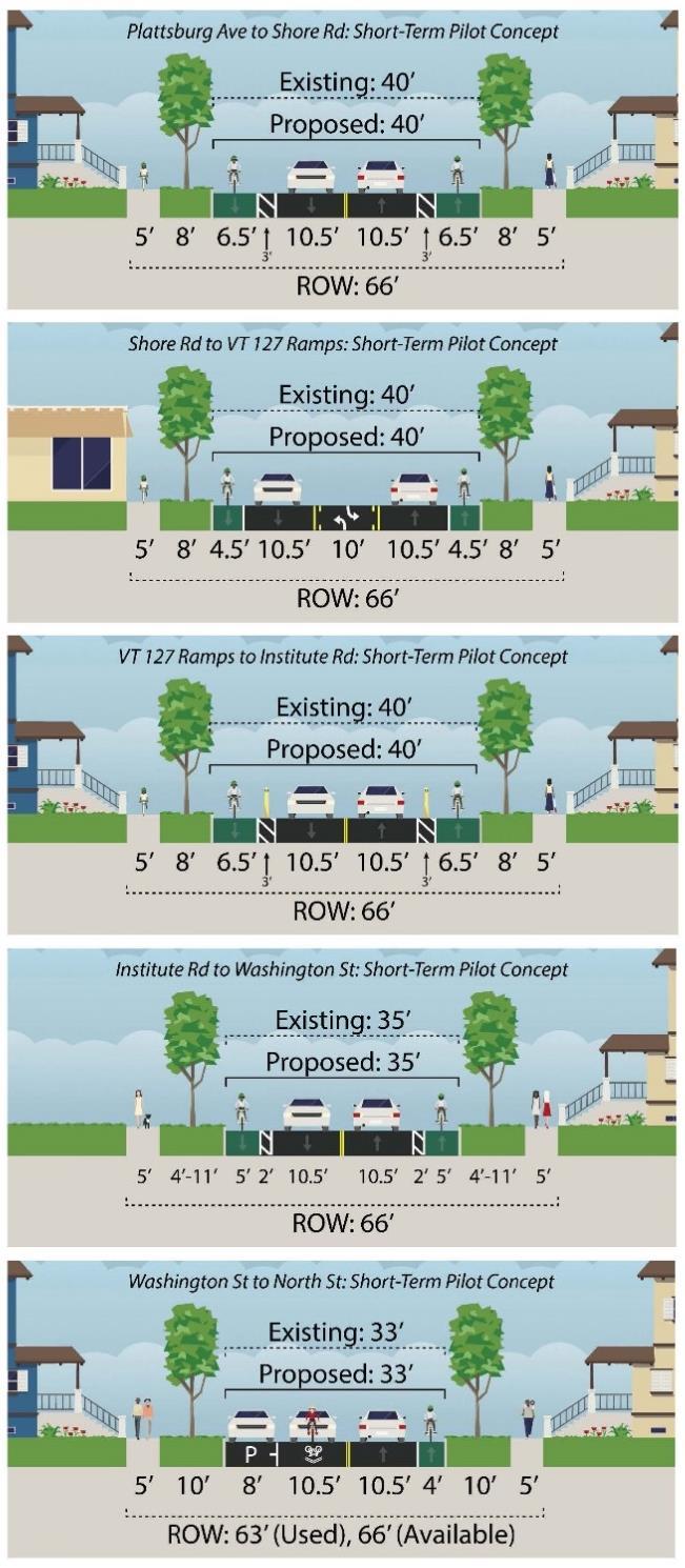

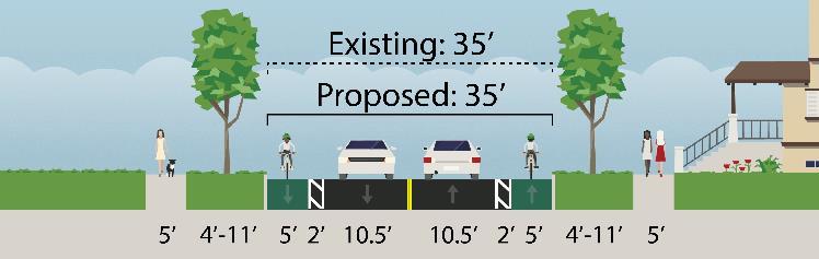
24 Short-Term Cross-Sections - 2 Concepts Study Team - Concept 1 Advisory Committee - Concept 2 24
25 Short-Term Cross-Section Concept Differences Major Differences between Concepts 1 and 2: Parking Concept 1: parking on one side (except between Shore Rd and VT 127) Concept 2: no parking north of Institute Rd Lane reassignment between Shore Rd and VT 127 Concept 1: medium-term implementation of 4- to 3-lane pilot project Concept 2: short-term implementation of 4- to 3-lane pilot project Bike Facilities Concept 1: short-term on-street bike lanes (except between Shore Rd and VT 127) Concept 2: short-tern on-street buffered/protected bike lanes north of Institute Rd Speed Limit Concept 1: No change in the short-term Concept 2: Implement 25 mph north of VT
26 Medium-Term Intersection Concepts Plattsburg Avenue: eliminate highspeed northbound right turn, add pedestrian activated no right on red. Ethan Allen Parkway: scoping to relocate Park entrance, add Little Eagle Bay into signal, eliminate high-speed northbound right turn. Shore Road: if ROW is donated or easily acquired, realign Shore Road, keep longer crossing times and pedestrian-activated no right on red. North Street: parking lot right in / right out or curb cut removal, realign north and south crosswalks, add protected / permitted southbound left turns, pedestrianactivated no right turn on red 26
27 Medium-Term crosswalks Washington Street: raised intersection Potential crosswalks for medium-or long-term: Ward Street Saratoga Avenue Poirier Place Loaldo Drive Lakewood Parkway Staniford Road Mid-block between VT 127 and Institute Road Convent Square Canfield Street 27

28 Medium-Term Cross-Section Concepts Study Team s Recommendation: 4- to 3-lane pilot project in medium-term This concept could move into the short-term implementation plan, pending an intensive public outreach effort and comprehensive data collection plan (e.g. traffic speeds, travel times, turning movements, bike/ped counts, crash incidents, public perception) 28
29 Long-Term Intersection Concepts Plattsburg Avenue: scoping for singlelane mini-roundabout Ethan Allen Shopping Center: reconstruct curb and sidewalk at Farrington s Mobile Home Park and Bamboo Hut Ethan Allen Parkway: implement scoping study recommendation (signal or roundabout) VT 127: scoping study for roundabout Institute Road: roundabout, resolve bus driveway 29
30 Long-Term Cross Sections Concept 30
31 High-Level Cost Estimates Concept Estimated Costs 4- to 3-lane pilot: Planning + implementation $52,000 Short Term: Basic Enhanced Crosswalks Intersections minor reconstruction Buffered / protected bike lanes Medium Term: Basic Enhanced Crosswalks Intersections $25,000 - $110,000 $70,000 $60,000 $45,000 - $180,000 TBD with scoping study Long Term cross section: On-Street One-Way Protected Bike Lanes $7,479,000 31
32 Creating a Corridor Plan Implementation Plan / Implementation Matrix Chapter 4 of Corridor Plan Corridor Plan Chapters & Appendices Corridor Study Process/Background Vision & Goals Existing & Future Conditions Development & Evaluation of Improvement Options Implementation Plan / Matrix Public Process Health Impact Assessment (Full Report) 32
33 TEUC Action
34 Decisionmaking The Transportation, Energy and Utilities Committee is asked to approve a North Avenue Implementation Plan (or elements of the Plan) and advance the final draft to the City Council for consideration and approval at the September 22, 2014 meeting. 34
35 Approving the Implementation Plan Short Term Implementation? At all intersections 1. ADA-compliant curb ramps and crosswalks on all approaches; 2. audible pedestrian countdown timers with a minimum 5- second (push-button) Leading Pedestrian Interval (LPI); and 3. bicycle facilities maintained through intersections (where provided in advance of intersections) New crosswalks: 1. Burlington College 2. Gosse Court 3. Killarney Drive / Village Green Drive 4. Green Acres / Cayuga Court 35
36 Approving the Implementation Plan Short Term Implementation? Shore Road: increase pedestrian crossing times, split phasing, pedestrianactivated no right turn on red. VT 127: remove high-speed northbound and westbound ramps Ethan Allen Shopping Center: increase pedestrian crossing times, pedestrian-activated no right turn on red. Institute Road: reduce intersection footprint, relocate northbound bus shelter, realign southbound sidewalk, pedestrian-activated no right turn on red
37 Approving the Implementation Plan Short Term Implementation? Cross sections: to 3- lane pilot project between Shore Road and VT 127? 2. On street parking north of Institute Road? mph speed limit?
38 Approving the Implementation Plan Medium Term Implementation? Washington Street: raised intersection Potential crosswalks for medium-or long-term: Ward Street Saratoga Avenue Poirier Place Loaldo Drive Lakewood Parkway Staniford Road Mid-block between VT 127 and Institute Road Convent Square Canfield Street
39 Approving the Implementation Plan Medium Term Implementation? Plattsburg Avenue: eliminate highspeed northbound right turn, add pedestrian activated no right on red. Ethan Allen Parkway: scoping to relocate Park entrance, add Little Eagle Bay into signal, eliminate high-speed northbound right turn. Shore Road: if ROW is donated or easily acquired, realign Shore Road, keep longer crossing times and pedestrian-activated no right on red. North Street: parking lot right in / right out or curb cut removal, realign north and south crosswalks, add protected / permitted southbound left turns, pedestrianactivated no right turn on red 39
40 Approving the Implementation Plan Plattsburg Avenue: scoping for singlelane mini-roundabout Ethan Allen Shopping Center: reconstruct curb and sidewalk at Farrington s Mobile Home Park and Bamboo Hut Ethan Allen Parkway: implement scoping study recommendation (signal or roundabout) VT 127: scoping study for roundabout Long Term Implementation? Institute Road: roundabout, resolve bus driveway 40
41 Approving the Implementation Plan Long Term Implementation? 41
42 Resources Project website: Vision and Goals Full text Existing and Future Conditions Report Draft Implementation Plan Public meeting agendas, meeting notes, and presentations Advisory Committee agendas, meeting notes, and presentations North Avenue Corridor Plan: Posted by September 15 th 42
43
North Avenue Corridor Study
 North Avenue Corridor Study City Council October 6, 2014 Presentation Outline Project Initiation & Process Corridor Conditions & Issues Vision & Goals Concept Development - Development/Evaluation Implementation
North Avenue Corridor Study
 North Avenue Corridor Study Advisory Committee Meeting #6 July 1, 2014 Agenda Concept Revisions based on Advisory Committee feedback Review of New Concept Scoring & Costs Concept Discussion/Questions Voting:
Explanation of Criteria. Cross Section Comparison. Cross Section Scores. Intersection Comparison. Intersection Scores. Corridor LTS Overall
 Worksheet Explanation of Criteria Cross Section Comparison Cross Section Scores Intersection Comparison Intersection Scores Corridor LTS Overall NACTO, BCSG Compliance Description This worksheet describes
Colchester/Riverside/Barrett/ Mill Intersection Study. PAC Meeting #3 September 22, 2016
 Colchester/Riverside/Barrett/ Mill Intersection Study PAC Meeting #3 September 22, 2016 Tonight s Agenda Review Project Purpose and Need Describe short term and long improvements and changes since public
Org Chart. Steering. Committee. Project Advisory. Committee. Nicole Losch, PTP Senior Transportation. Bryan Davis, AICP Senior Transportation
 1 Org Chart Project Advisory Committee Steering Committee Nicole Losch, PTP Senior Transportation Planner Bryan Davis, AICP Senior Transportation Planner Jonathan Slason, PE Project Manager Diane Meyerhoff
Proposed. City of Grand Junction Complete Streets Policy. Exhibit 10
 Proposed City of Grand Junction Complete Streets Policy Exhibit 10 1 City of Grand Junction Complete Streets Policy Vision: The Complete Streets Vision is to develop a safe, efficient, and reliable travel
Telegraph Avenue Complete Streets DRAFT Recommendations. Oakland Public Works Department September 11 and 13, 2014 Open Houses
 Telegraph Avenue Complete Streets DRAFT Recommendations Oakland Public Works Department September 11 and 13, 2014 Open Houses Presentation Overview What are complete streets? What problem are we trying
APPENDIX A: Complete Streets Checklist DRAFT NOVEMBER 2016
 APPENDIX A: Complete Streets Checklist DRAFT NOVEMBER 2016 Complete Streets Checklist MetroPlan Orlando s Complete Streets Checklist is an internal planning tool for staff to further implementation of
Downtown Naples Mobility and Connectivity Study. Naples City Council Presentation January 2017
 Downtown Naples Mobility and Connectivity Study Naples City Council Presentation January 2017 Agenda 1. Introduction 2. Scope Review 3. Project Schedule 4. Existing Conditions 5. Public Charrette 6. Mobility
Balancing Operation & Safety for Motorized and Non-Motorized Traffic
 Balancing Operation & Safety for Motorized and Non-Motorized Traffic Brian Willham, PE, PTOE Iowa Director - MOVITE June 30, 2014 Learning Objectives: When & Why should we measure the performance of complete
Los Altos Hills Town Council - June 18, 2015 Palo Alto City Council June 22, AGENDA ITEM #2.B Presentation
 Los Altos Hills Town Council - June 18, 2015 Palo Alto City Council June 22, 2015 AGENDA ITEM #2.B Presentation Previous Presentations Los Altos Hills Town Council in May 2014 and February 2015 Palo Alto
Providence Downtown Transit Connector STAKEHOLDER MEETING #2. Stakeholder Meeting #1 October 24, 2016
 Providence Downtown Transit Connector STAKEHOLDER MEETING #2 Stakeholder Meeting #1 October 24, 2016 February 2017 1 AGENDA 1 DTC Goals and Expectations 2 Street Design Concepts 3 Potential Benefits and
Corpus Christi Metropolitan Transportation Plan Fiscal Year Introduction:
 Introduction: The Safe, Accountable, Flexible, Efficient Transportation Equity Act: A Legacy for Users (SAFETEA-LU) has continued the efforts started through the Intermodal Surface Transportation Efficiency
STONY PLAIN ROAD STREETSCAPE
 Jasper Place Revitalization Strategy: Vision The people involved in the Jasper Place Revitalization Strategy envision: Goal 1: Feeling safe in our community Create a community where feeling safe is common--where
Clybourn Ave. Protected Bike Lane Study Halsted St. to Division St.
 Clybourn Ave. Protected Bike Lane Study Halsted St. to Division St. Nathan Roseberry, Senior Engineer Pam Broviak, Project Manager July 24, 2014 Agenda Project Goals Existing Roadway Conditions Traffic
Princeton Avenue and Spruce Street Transportation and Site Access Enhancements Project
 Princeton Avenue and Spruce Street Transportation and Site Access Enhancements Project Mercer County Planning Division AECOM Transportation (formerly DMJM Harris) January 29, 2009 Agenda Project Status
Tonight is for you. Learn everything you can. Share all your ideas.
 Strathcona Neighbourhood Renewal Draft Concept Design Tonight is for you. Learn everything you can. Share all your ideas. What is Neighbourhood Renewal? Creating a design with you for your neighbourhood.
EXECUTIVE SUMMARY. Vision
 Vision Walking and bicycling in Salt Lake City will be safe, convenient, comfortable, and viable transportation options that connect people to places, foster recreational and economic development opportunities,
Preliminary Transportation Analysis
 Preliminary Transportation Analysis Goals of a Robust, Multimodal Transportation Network Safe Accessible/Connected Efficient Comfortable Context-Sensitive Motor Vehicle: Continue to analyze the data to
PROJECT OBJECTIVES. Improve vehicle capacity for the intersection. Improve pedestrian and bicycle access
 COMMUNITY MEETING Project Update March 15, 2010 Purcellville, Virginia OVERVIEW Project need / objectives Project recap Design elements Proposed improvements Summary of project benefits / next steps PROJECT
Org Chart. Steering. Committee. Project Advisory. Committee. Nicole Losch, PTP Senior Transportation. Bryan Davis, AICP Senior Transportation
 1 Org Chart Project Advisory Committee Steering Committee Nicole Losch, PTP Senior Transportation Planner Bryan Davis, AICP Senior Transportation Planner Jonathan Slason, PE Project Manager Diane Meyerhoff
Omaha s Complete Streets Policy
 Omaha s Complete Streets Policy (Adopted August 2015) VISION To create great places and enhance our quality of life, the City of Omaha will provide safe, accessible streets for all users. Complete Streets
» Draft Recommendations» Discussion» Next Steps. Plan for Walking and Biking
 SAC Meeting Plan #3 for September Walking and 12, Biking 2018 » Draft Recommendations» Discussion» Next Steps Plan for Walking and Biking » Stakeholder and Public Outreach» Background data collection and
Mission-Geneva Transportation Study Community Workshop 2 July 8, 2006
 Community Workshop 2 July 8, 2006 Small Group Workbook 1 Basic Improvements on Mission Street Streetscape. Pedestrian-scale lighting; landscaping; community art on utility boxes; more (possibly unique)
PRINCE GEORGE S PLAZA METRO AREA PEDESTRIAN PLAN
 PRINCE GEORGE S PLAZA METRO AREA PEDESTRIAN PLAN May 28, 2008 Agenda Welcome and introductions Project overview and issue identification Planning context and strengths Design challenges and initial recommendations
City of Gainesville Transportation/Roadway Needs PROJECT SUMMARY
 A1 Roadway Resurfacing $23,846,000 TYPE: Preservation of existing system Roadway resurfacing A2 Signal Replacement $6,000,000 TYPE: Preservation of existing system Replace traffic signals. B1 W 6th St
Washington St. Corridor Study
 FIGURE 7.17 Bridge Alternatives - Cross Sections 86 Discarded Alternative: Short-Term Bridge Repair Short-term repairs and west bridge span replacement were considered during analysis. Short-term repairs
Welcome to the Quebec Alternatives Analysis Public Meeting
 Welcome to the Public Meeting Please sign in. Public Comment Please fill out a comment card and tell us what you think. Check back or comment any time at: www.quebecalternatives.com Project Area Technical
REGIONAL BICYCLE AND PEDESTRIAN DESIGN GUIDELINES
 REGIONAL BICYCLE AND PEDESTRIAN DESIGN GUIDELINES November 16, 2011 Deb Humphreys North Central Texas Council of Governments Bicycle and Pedestrian Advisory Committee Snapshot of the Guide 1. Introduction
City of Wilsonville 5 th Street to Kinsman Road Extension Project
 City of Wilsonville 5 th Street to Kinsman Road Walking Tour & Neighborhood Workshop Summary Report Public Outreach Overview On July 18 th, 2017, the City of Wilsonville hosted a neighborhood walking tour
5. RUNNINGWAY GUIDELINES
 5. RUNNINGWAY GUIDELINES These guidelines should be considered collectively when making runningway decisions. A runningway is the linear component of the transit system that forms the right-of-way reserved
Agenda. Overview PRINCE GEORGE S PLAZA METRO AREA PEDESTRIAN PLAN
 PRINCE GEORGE S PLAZA METRO AREA PEDESTRIAN PLAN May 28, 2008 Agenda Welcome and introductions Project overview and issue identification Planning context and strengths Design challenges and initial recommendations
WELCOME. Stakeholder Involvement Group Meeting #2 Round Lake Public Works October 24, 2018
 WELCOME Stakeholder Involvement Group Meeting #2 Round Lake Public Works October 24, 2018 MEETING AGENDA 1. Welcome and Introductions 2. Study Progress Update 3. Problem Statement 4. Technical Analysis
Complete Streets. Designing Streets for Everyone. Sarnia
 Complete Streets Designing Streets for Everyone Sarnia Complete Streets ~ Sarnia ~ 2018 Introduction Our City is made up of a network of streets that we use to go for a walk, cycle to work, drive to the
The DC Pedestrian Master Plan
 The DC Pedestrian Master Plan September 28, 2010 George Branyan Pedestrian Program Coordinator District Department of Transportation Presentation Agenda Scope of the Plan Methodology Recommendations Implementation
RapidRide Roosevelt Seat Sea t t le t le Depa De r pa t r men men t of Sept T an r sp an or sp t or a t t a ion
 RapidRide Roosevelt Seattle Bicycle Advisory Board 1 Our mission, vision, and core values Mission: deliver a high-quality transportation system for Seattle Vision: connected people, places, and products
Monterey Road Complete Streets
 Monterey Road Complete Streets Complete Street Objectives Improve livability and economic vitality Enhance pedestrian environment Accommodate bicyclists safely Reduce noise and air pollution Create attractive,
Albany Shaker Road Corridor Study Public Meeting # 2
 Albany Shaker Road Corridor Study Public Meeting # 2 Scope / Meeting Purpose This project is a CDTC Linkage Study. The Linkage Program is designed to implement the adopted planning and investment principles
COMMUNITY MEETING AGENDA
 COMMUNITY MEETING AGENDA Welcome and Introductions SAFE Presentation Project Presentation Priorities Feedback Next Steps Q&A Santa Cruz Avenue Corridor Study 1 Santa Cruz Avenue Corridor Study Community
Making Phoenix Streets Complete. City of Phoenix Complete Streets Initiative
 Making Phoenix Streets Complete City of Phoenix Complete Streets Initiative City of Phoenix Planning Commission March 2014 Presentation Outline What are Complete Streets? Benefits of Complete Streets Complete
OCALA/MARION TPO CITY OF BELLEVIEW CORRIDOR PLAN STUDY PRESENTATION TO THE BELLEVIEW CITY COMMISSION JANUARY 25, :00 PM
 OCALA/MARION TPO CITY OF BELLEVIEW CORRIDOR PLAN STUDY PRESENTATION TO THE BELLEVIEW CITY COMMISSION JANUARY 25, 2016 6:00 PM STUDY AREA Ocala/Marion TPO US-441 Corridor Study 2 Ocala/Marion TPO US-441
Item to be Addressed Checklist Consideration YES NO N/A Required Description Complete Streets Guidelines
 Passaic County Complete Streets Checklist - Concept Development Project Name Item to be Addressed Checklist Consideration YES NO N/A Required Description Complete Streets Guidelines Existing Plans Have
Meadow Woods Elementary School
 Drag and drop pic and stretch/crop to the limits of the blue rectangle (delete this text box) Meadow Woods Elementary School Drag and drop pic and stretch/crop to the limits of the blue rectangle (delete
2014/2015 BIKE ROUTE PLAN 83 AVENUE PROTECTED BIKE LANE
 About the Project 2014/2015 BIKE ROUTE PLAN The City of Edmonton is planning a major bike route on the south side of Edmonton. This bike route is one part of a plan to provide citizens with transportation
Broad Street Bicycle Boulevard Design Guidelines
 Broad Street Bicycle Boulevard Design Guidelines Building from the strategies introduced in the 2013 Bicycle Transportation Plan and community input received thus far, City Transportation Staff have identified
CITY OF LOS ANGELES INTER-DEPARTMENTAL MEMORANDUM
 CITY OF LOS ANGELES INTER-DEPARTMENTAL MEMORANDUM Date: April 1, 219 To: Honorable City Council c/o City Clerk, Room 395, City Hall Attention: Honorable Mike Bonin, Chair, Transportation Committee From:
Public Open House #2. THE CITY OF NORTH VANCOUVER CHESTERFIELD AVENUE CYCLING IMPROVEMENTS (4th - 13th STREET) JULY 2013
 JULY 2013") CHESTERFIELD AVENUE CYCLING IMPROVEMENTS (4th - 13th Street) Public Open House #2 1 Chesterfield Avenue provides an important north/south connection between Lonsdale Quay and West 23rd Street Purpose of
CHESTERFIELD AVENUE CYCLING IMPROVEMENTS (4th - 13th Street) Public Open House #2 1 Chesterfield Avenue provides an important north/south connection between Lonsdale Quay and West 23rd Street Purpose of
122 Avenue: 107 Street to Fort Road
 : 107 Street to Fort Road November 24, 2015 4:30 8:00 p.m. Meeting Purpose Summarize project work completed to date Share results of public input from Phase 1 Share the draft concept plan and proposed
NJDOT Complete Streets Checklist
 Background The New Jersey Department of Transportation s Complete Streets Policy promotes a comprehensive, integrated, connected multi-modal network by providing connections to bicycling and walking trip
BETHEL ROAD AND SEDGWICK ROAD CORRIDOR STUDY
 DRAFT PLAN City Council Meeting August 14, 2017 STUDY AREA Sedgwick Corridor State Route 160, principal arterial with Class 3 access management designation, commuter and freight route, connection to SR
Public Works Committee Meeting Richard E. Mastrangelo Council Chamber November 20, 2017
 Public Works Committee Meeting Richard E. Mastrangelo Council Chamber November 20, 2017 Purpose of Meeting Why are we here? Project Recap/Updates Project Limits/Segments Road Diet Concept Lessons Learned
Pedestrian & Bicycle Safety Innovations & Applications
 Pedestrian & Bicycle Safety Innovations & Applications County Engineers Association of Maryland Spring, 2017 Conference May 25, 2017 George Branyan Pedestrian Program Coordinator District Department of
Southview Blvd & 3 rd Avenue Improvement Project. Public Open House December 4, to 7pm
 Southview Blvd & 3 rd Avenue Improvement Project Public Open House December 4, 2014 5 to 7pm Southview Blvd & 3 rd Avenue Public Information Meeting Agenda Presentation 5:30 to 6:15 pm Purpose of Project
Stakeholder Update. Agenda. Project update Needs Identification Strategy Proposed needs Safety Collectors/Arterials Greenways Local roads
 1 Stakeholder Update May 21, 2018 2 Agenda Project update Needs Identification Strategy Proposed needs Safety Collectors/Arterials Greenways Local roads Proposed Evaluation Criteria Next Steps 1 Project/Schedule
2014/2015 BIKE ROUTE PLAN 83 AVENUE PROTECTED BIKE LANE
 About the Project The City of Edmonton is planning a major bike route on the southside of Edmonton. The Strathcona Bike Route will connect the communities of Strathcona, Garneau and the University area,
COWETA HIGH SCHOOL AND EAST HIGHWAY 51
 COWETA HIGH SCHOOL AND EAST HIGHWAY 51 Lack of sidewalks along Ben Lumpkin Rd. Lack of crosswalks and ramps at intersection. Hwy 51 is wide to cross as a pedestrian. No ADA compliance or connection to
Road Diets FDOT Process
 Florida Department of TRANSPORTATION Road Diets FDOT Process Humberto Castillero, PE, PTOE Roadway Design Office Purpose of Guide Develop a statewide lane elimination review process Balance state & local
Sandwich Pedestrian/Bicycle Planning
 Sandwich Pedestrian/Bicycle Planning Improved Pedestrian and Bicycle Connections with the Cape Cod Canal Multi-use Path February 2014 Table of Contents Introduction... 1 Background... 1 Study Goals...
THE ALAMEDA CONCEPT DESIGN COMMUNITY MEETING 3. A Plan for The Beautiful Way JANUARY 28, 2010
 CONCEPT DESIGN COMMUNITY MEETING 3 JANUARY 28, 2010 AGENDA INTRODUCTION COMMUNITY INPUT ROADWAY STUDIES STREETSCAPE DESIGN STATIONS DISCUSSION SUMMARY AND DISCUSSION NEXT STEPS CLOSE INTRODUCTION SCHEDULE
A Complete Streets Policy for Saratoga Springs. Presented By: Shared Access Saratoga
 A Complete Streets Policy for Saratoga Springs Presented By: Shared Access Saratoga April 17, 2012 Agenda 1. Introduction to Complete Streets (CS) 2. Shared Access Saratoga 3. Why is CS Important 4. What
Complete Streets Workshop Follow-up. April 27, 2011 Rockledge City Hall
 Complete Streets Workshop Follow-up April 27, 2011 Rockledge City Hall Agenda Complete Streets draft briefing presentation and sample policy language Share your Complete Streets projects and post workshop
Maywood Town Hall Meeting. May 4, 2016
 Maywood Town Hall Meeting May 4, 2016 1 AGENDA Overall I-290 Study Background Maywood Advisory Working Group (AWG) findings to date Noise Wall Update Next Steps 2 Questions? Study team members also available
Vision. Goals and Objectives. Walking
 Vision Walking and biking is an accepted and valued part of everyday life in Portsmouth. People of all ages and abilities include walking and biking as part of their daily activities which helps to make
HARRISON STREET/OAKLAND AVENUE COMMUNITY TRANSPORTATION PLAN
 HARRISON STREET/OAKLAND AVENUE Community Workshop #4: Draft Plan Review December 3, 2009 D E S I G N, C O M M U N I T Y & E N V I R O N M E N T INTRODUCTIONS Key Project Staff: Alisa Shen, Project Manager,
4. ENVIRONMENTAL IMPACT ANALYSIS 9. TRANSPORTATION AND TRAFFIC
 4. ENVIRONMENTAL IMPACT ANALYSIS 9. TRANSPORTATION AND TRAFFIC 4.9.1 INTRODUCTION The following section addresses the Proposed Project s impact on transportation and traffic based on the Traffic Study
Bicycle and Pedestrian Connectivity Study. Old Colony Planning Council
 Bicycle and Pedestrian Connectivity Study Old Colony Planning Council Outline Why consider bike/peds in road designs? Why are measures needed? Connecting Land Use with Transportation Evaluation Tools:
Cycle Track Design Best Practices Cycle Track Sections
 Design Best Practices Sections It is along street segments where the separation and protection methods of cycle tracks offer more comfort than conventional bicycle lanes, and are more attractive to a wide
Watertown Complete Streets Prioritization Plan. Public Meeting #1 December 14, 2017
 Watertown Complete Streets Prioritization Plan Public Meeting #1 December 14, 2017 Goals for Public Meeting Overview of MassDOT Complete Streets Funding Program Educate the community on Complete Streets
6.4 RECOMMENDED IMPROVEMENTS
 6.4 RECOMMENDED IMPROVEMENTS 6.4.1 Williston Road Recommendations While all alternatives would be an improvement over existing conditions, Alternative 3B is recommended over the others because it provides
Community Task Force July 25, 2017
 Community Task Force July 25, 2017 Welcome and Introductions Project Partners Regional Transportation District (RTD) Colorado Department of Transportation (CDOT) Denver Regional Council of Governments
San Jose Transportation Policy
 San Jose Transportation Policy Protected Intersections in LOS Policies to Support Smart Growth Presented by: Manuel Pineda City of San Jose Department of Transportation Bay Area Map San Francisco Oakland
Typical Cross Section: DOWNTOWN (Observer Highway - 8th Street)
") Typical Cross Section: DOWNTOWN (Observer Highway - 8th Street) DRAFT SEPTEMBER 23, 14 1 Washington Street Typical Block Downtown Typical Block: DOWNTOWN (Observer Highway - 8th Street) New crosswalks
Typical Cross Section: DOWNTOWN (Observer Highway - 8th Street) DRAFT SEPTEMBER 23, 14 1 Washington Street Typical Block Downtown Typical Block: DOWNTOWN (Observer Highway - 8th Street) New crosswalks
Welcome. If you have any questions or comments on the project, please contact:
 Welcome This drop-in public open house is intended to provide information about the Bay Street bike lanes project. This project proposes a dedicated cycling facility along Bay Street between Aberdeen Avenue
Completing the Street: Denning Drive
 Completing the Street: Denning Drive Public Workshop and Walking Audit Winter Park Civic Center May 12, 2016 Completing the Street What Makes This a Complete Street? Completing the Street Complete Streets
Hennepin County Pedestrian Plan Public Comment Report
 Hennepin County Pedestrian Plan Public Comment Report On May 31, 2013, the draft Hennepin County Pedestrian Plan was released for a 45-day public comment period ending July 15, 2013. The county received
MASTER BICYCLE AND PEDESTRIAN PLAN
 VILLAGE OF NORTHBROOK MASTER BICYCLE AND PEDESTRIAN PLAN DRAFT PLAN OPEN HOUSE May 2, 2018 AGENDA 1. Community Engagement 2. Vision and Goals 3. General Structure of Plan 4. Recommendations Overview 5.
Active Transportation Facility Glossary
 Active Transportation Facility Glossary This document defines different active transportation facilities and suggests appropriate corridor types. Click on a facility type to jump to its definition. Bike
Pine Hills Road Pedestrian/Bicycle Safety Study Board of County Commissioners Work Session
 Pine Hills Road Pedestrian/Bicycle Safety Study Board of County Commissioners Work Session February 20, 2018 Meeting Agenda Study Overview Existing Conditions Access Management Potential Gateway Features
C C C
 C-012-001 Thank you for your support for the creation of new public space and nonmotorized access between downtown and the waterfront through the Overlook Walk, the East-West Connections, and the Promenade.
Living Streets Policy
 Living Streets Policy Introduction Living streets balance the needs of motorists, bicyclists, pedestrians and transit riders in ways that promote safety and convenience, enhance community identity, create
California Department of Transportation, District 4. Sloat Boulevard Project Skyline Blvd. to 19 th Ave. Community Update January 13, 2016
 California Department of Transportation, District 4 Sloat Boulevard Project Skyline Blvd. to 19 th Ave. Community Update January 13, 2016 Agenda Welcome and introductions Project overview, history and
North Shore Transportation Improvement Strategy
 North Shore Transportation Improvement Strategy Preliminary, Near-term Recommendation 2016 April Transportation Improvement Strategy (TIS) Comprehensive and Analytical A multi-modal transportation strategy
Environment and Public Works Committee Presentation
 Mixed Use Centers Complete Streets Guidelines Project Environment and Public Works Committee Presentation December 10, 2008 Project Objectives: Conduct an inter-departmental and agency process to study
Summary: Mercer County Princeton Avenue & Spruce Street Study January 2009
 Summary: Several recent studies have assessed potential development and redevelopment opportunities in the Mercer Crossing area of Trenton, Ewing, and Lawrence. This Princeton Avenue and Spruce Street
MAG Town of Cave Creek Bike Study Task 6 Executive Summary and Regional Significance Report
 Page 1 MAG Town of Cave Creek Bike Study Task 6 Executive Summary and Regional Significance Report August 1, 2012 MAG Project #481 Page 2 Task 6 Executive Summary and Regional Significance Report Introduction
STEERING COMMITTEE MEETING June 17, Streetscape Overview Burlington Comprehensive Master Plan
 STEERING COMMITTEE MEETING June 17, 2015 Streetscape Overview Burlington Comprehensive Master Plan 1 Introduction Slide This slide show was presented to the Burlington Steering Committee on June 17, 2015
Designing for Pedestrian Safety in Washington, DC
 Designing for Pedestrian Safety in Washington, DC February 25, 2014 George Branyan Pedestrian Program Coordinator District Department of Transportation DC Journey to work mode split: 2012 Means of Transportation
Executive Summary Route 30 Corridor Master Plan
 Route Corridor Master Plan Project Overview The Route Corridor Master Plan is a coordinated multimodal transportation and land use plan for the entire stretch of Route through East Whiteland Township,
Route 79/Davol Street Corridor Study
 Route 79/Davol Street Corridor Study Fall River, MA Public Information Meeting #2 November 21, 2013 Fall River Heritage State Park Fall River, MA Agenda Welcome and Introductions Overview of Study Process
What Is a Complete Street?
 Session 5 Charleen Zimmer, AICP, Zan Associates May 5-7, 2010 What Is a Complete Street? May 2010 5-1 Not a Complete Street More of a Complete Street May 2010 5-2 Benefits of Complete Streets Safety for
TOWN OF PORTLAND, CONNECTICUT COMPLETE STREETS POLICY
 TOWN OF PORTLAND, CONNECTICUT COMPLETE STREETS POLICY I. VISION, GOALS & PRINCIPLES VISION To improve the streets of Portland making them safer and more accessible for all users including pedestrians,
2018 Pedestrian and Bicycle and Safe Routes to School Application for Funding Page 1 of 31
 2018 Pedestrian and Bicycle and Safe Routes to School Application for Funding Page 1 of 31 2018 Pedestrian and Bicycle and Safe Routes to School Application for Funding Part 1: General Information Funding
City of Seattle Edward B. Murray, Mayor
 City of Seattle Edward B. Murray, Mayor Department of Transportation Scott Kubly, Director Eastlake Community Council 117 E Louisa St. #1 Seattle, WA 98102-3278 January 28, 2016 RE: Roosevelt to Downtown
Pennsylvania Avenue (CR 484) Design Alternatives Study
 Design Alternatives Study") MEMORANDUM Pennsylvania Avenue (CR 484) Design Alternatives Study Prepared for: APRIL 2016 Prepared By TABLE OF CONTENTS Project Background... 2 Previous Concept... 2 Existing Conditions... 4 New Alternatives...
MEMORANDUM Pennsylvania Avenue (CR 484) Design Alternatives Study Prepared for: APRIL 2016 Prepared By TABLE OF CONTENTS Project Background... 2 Previous Concept... 2 Existing Conditions... 4 New Alternatives...
Bicycle Facilities Planning
 Bicycle Facilities Planning Overview Types of Cyclists Purpose for Riding Types of Facilities Bike Lanes Bicycle Boulevards Cycle Tracks Intersections Signals Signing and Marking Discussion Types of Bicyclists
CONNECTIVITY PLAN. Adopted December 5, 2017 City of Virginia Beach
 CONNECTIVITY PLAN Adopted December 5, 2017 City of Virginia Beach CONTENTS 1.0 Background & Purpose... 2 2.0 Existing Inventory & Analysis... 3 ViBe District Existing Walking Conditions... 4 3.0 ViBe District
CITY OF COCOA BEACH 2025 COMPREHENSIVE PLAN. Section VIII Mobility Element Goals, Objectives, and Policies
 CITY OF COCOA BEACH 2025 COMPREHENSIVE PLAN Section VIII Mobility Element Goals, Objectives, and Policies Adopted August 6, 2015 by Ordinance No. 1591 VIII MOBILITY ELEMENT Table of Contents Page Number
Main-McVay Transit Study: Phase 2 Options Definition and High Level Constraints Evaluation
 Main-McVay Transit Study: Phase 2 Options Definition and High Level Constraints Evaluation APRIL 2016 A collaborative study between: For Additional Information or to Comment If you would like additional
Southbend to Prima Vista. October 30, Floresta Corridor Master Plan
 Application of a Complete Street initiative and how it might function operationally 8 8 Southbend to Prima Vista October 30, 2017 Presentation Agenda 2 Perspective and History Traffic projections, Levels
Columbia Pike Implementation Team (CPIT) Meeting
 Meeting") Columbia Pike Implementation Team (CPIT) Meeting November 30, 2010 Agenda Introductions / Purpose of Meeting Review of project goals Multimodal project: 10% street design between the curbs Discussion Multimodal
Columbia Pike Implementation Team (CPIT) Meeting November 30, 2010 Agenda Introductions / Purpose of Meeting Review of project goals Multimodal project: 10% street design between the curbs Discussion Multimodal