Windom Area Schools District #177 Safe Routes to School Plan Winfair Elementary & the Middle School January 2014
|
|
|
- Gertrude Kelly
- 5 years ago
- Views:
Transcription

1 Windom Area Schools District #177 Safe Routes to School Plan Winfair Elementary & the Middle School January 2014 Prepared by: Southwest Regional Development Commission 2401 Broadway Avenue, Suite 1 Slayton, Minnesota General srdc@swrdc.org
2 Table of Contents Summary Geographic Location...3 Windom Area School District Map of Windom Planning Process Existing Health Issues..10, 11 Traffic Volumes 12, 13 Crash Data Existing Conditions Winfair Elementary Existing Conditions Map Winfair Elementary , 21 Existing Conditions Middle / High School Existing Conditions Map Middle / High School , 27 Recommendations / Vision , 29 Short Term Goals / Action Steps Long Term Goals / Action Steps Implementation Implementation: Winfair Elementary Drop-off and Pick-up Lane Conclusion References Appendix A: Parent Survey Winfair Elementary 2010, Appendix B: Parent Survey Middle School 2010, 2011, Appendix C: Travel Tallies Winfair Elementary 2010, 2011, 2012, Appendix D: Travel Tallies Middle School 2010, 2011, 2013, Appendix E: Bus Stops....87, 88 Handouts


3 Summary Safe Routes to School (SRTS) Plans are community plans to promote an active lifestyle for all residents. The focus of SRTS Plans are on teaching children pedestrian and bicycle safety, making the environment safer for children to walk and bicycle to school and around the community, and promote a healthy lifestyle. SRTS Plans encourage children and the community as a whole to walk, bike, and be more physically active. By promoting a more active lifestyle, there are a number of positive externalities that include: reduced traffic congestion near schools and in the community, better air quality around schools and in the community, and an overall healthier community. Geographic Location The City of Windom is situated in southwest Minnesota around the point of intersection of U.S. Highway 71, Minnesota Highway 60, and the Des Moines River. Windom is located in the southern section of Cottonwood County. Cottonwood County lies on the edge of the Buffalo Ridge in southern Minnesota. The county s boundaries are joined by Redwood and Brown County to the north, Watonwan County to the east, Jackson County to the south, and Murray County to the west. The topography of the area varies from the Des Moines River to scenic rural settings. The rural nature of the Cottonwood County contributes greatly to the overall appeal of the community. 3


4 Windom Area Schools The Windom Area School District is a rural district encompassing parts of Cottonwood and Jackson County. The Windom Area School District includes the City of Windom, the county seat where U.S. Highway 60 and 71 meet, along with the communities of Wilder and Bingham Lake. The Windom Area School District encompasses 203 square miles and has a Pre-K 12 th Grade Enrollment of 985 students in the school year. The district includes: Windom Area Middle and High School, Winfair Elementary, and Early Childhood Family Education. Windom Area Middle and High School is located at th Street in Windom, Minnesota. Winfair Elementary is located at th Ave. in Windom, Minnesota. The Windom SRTS Plan is for Winfair Elementary and the Middle School. Winfair Elementary serves the entire district for grades Kindergarten through 3 rd grade. The school year enrollment is 359 students at Winfair Elementary. The Middle School serves the entire district for grades 4th through 8th grade. The school year enrollment is 381 students at the Middle School. Picture of Winfair Elementary 4

5 City of Windom Legend Winfair Elementary Middle / High School N Created By SRDC
6 Planning Process The Windom Area Schools SRTS Program was initiated through the local Statewide Health Improvement Program (SHIP) in September of Community participation has played a critical role in developing the SRTS program. The Windom Area Schools SRTS Team (here after referred to as SRTS Team) has made substantial progress in promoting a more active lifestyle and making it safer for children to walk and bicycle to school. Existing Conditions The planning process for promoting a more active lifestyle and making it safer for children to walk and bicycle to and from school started with a walking audit that was held on September 17, The walking audit assessed the existing conditions within two to three blocks of Winfair Elementary and the Middle School. The walking audit was coordinated with help from SHIP Coordinator in Cottonwood County. A kickoff meeting was then held by the Chairperson of the SRTS Team, Shannon LaCanne, on September 24, This kickoff meeting discussed the existing conditions outline in the walking audit and what strategies the Windom Area Schools SRTS Program should pursue. The SHIP Coordinator emphasized the importance of tracking the number of students walking and bicycling to school. Along with analyzing existing conditions and conducting the walking audit, the SRTS Team helped administer a parent survey and a student travel tally survey in the Fall of 2010 and the Spring of These two surveys help create a benchmark regarding the number of students walking and bicycling to school. Concerns outlined by the SRTS Team were discussed during a town hall meeting in November of The SRTS Team expressed the importance of SHIP encouraging and supporting programs to promote walking and bicycling to school and being more active. State Representative, Rod Hamilton was very receptive and encouraged the SRTS Team to keep 6
7 Planning Process trying for funds to pursue projects to promote and make it safe for students to walk and bicycle to school. Another community meeting was held in December of 2010, to further discuss the existing conditions. The SRTS Team presented on the concerns that have been outlined in previous meetings. The main agenda item of this meeting was to decide where to go from here. Jill Chamberlin, with Blue Cross Blue Shield, was in attendance to offer input regarding opportunities Blue Cross Blue Shield could assist with. Goals Setting A SRTS Team meeting was held on January 19 th, 2011, to finalize the SRTS Team s Vision and to develop short and long term goals. Short term goals were defined as one to three years, and long term goals were defined as three to five years. The goal setting meeting helped to summarize all of the current issues impacting walking and bicycling to school. The result of the meeting was a list of potential goals and strategies and a formal vision statement. A follow-up goals meeting was held between the SRTS Team and the Windom Street Department and Chief of Police to discuss and gain approval for potential strategies outlined in the previous meeting. The SRTS Team needed approval from the Windom Street Department and Chief of Police to move forward with multiple strategies. A goal review meeting was held during a Windom City Council Meeting on March 15, SRTS Team members presented the action plan that outlined the short and long term goals and strategies. The presentation was to educate the City Council about SRTS and garner support for the projects moving forward. Formal action was not taken at the City Council meeting for or against any of the proposed goals and strategies. 7
8 Planning Process Informal Planning Process The informal planning process is the planning that takes place between meetings amongst parents, teachers, community members, and the SRST Team. The informal planning process was critical in the development of the vision statement and the short term and long term goals. SRTS Team members spent a great deal of time discussing existing conditions and ways to mitigate obstacles for students to safely be able to walk and bicycle to school. The informal planning process contained elements regarding the informal discussion of existing conditions, alternative goals and strategies, the feasibility of proposed goals and strategies, and the timeline for implementation. The Windom Area Schools SRTS Plan is more of a continuing or ongoing plan. The goals and strategies evolved during the formal planning process of gathering information, identifying existing conditions, assessing the issues and barriers, developing goals and strategies, implementing the plan, monitoring the performance, and evaluating the plan. Continuing plans retain their value over a period of time while undergoing periodic revisions and updates. The informal development of the Windom Area Schools SRTS Plan allowed for the plan to garner community input and continually evolve to January Implementation There has been multiple implementation meetings since the goals and strategies were agreed upon in March of Refer to the section titled Implementation for progress made since the original goals and strategies were developed. 8

9 Planning Process Windom SRTS Team Shannon LaCanne; SRTS Chairperson, Exercise Physiologist/ Wellness & Cardiac Rehab Director, Parent Bonnie Frederickson; Cottonwood County SHIP Coordinator Steve Nasby; City Administrator Wayne Wormstadt; Superintendent Lisa Edwards; Winfair Elementary School Principal Eric Hanson; Middle School and High School Principal Bob Duncan; School Transportation Director Joe LaCanne; School Board member, Grandparent Teri Elder; Physical Therapist, Parent Trevor Slette; Citizen, Parent Deann Steele; Business Owner, Parent Angela Schlager; SHIP Coordinator Intern 9

10 Existing Health Issues Research conducted by the USDA shows that one in three American children are overweight or obese, putting them at risk of preventable disease like diabetes, high blood pressure, and heart disease. Being overweight or obese not only increases the risk of premature death and many other diseases and health conditions, but there are substantial economic costs as well. There are both direct and indirect costs associated with being overweight or obese. Direct costs are the higher medical costs associated with diagnosing, treating, and trying to prevent conditions related to being overweight or obese. Indirect costs of being overweight or obese include morbidity and mortality costs such as loss in productivity, absenteeism, and premature death. Based on national estimates, the overall financial burden of obesity in Minnesota in 2006 was estimated at $2.8 billion. 1 The medical costs associated with obesity nationally, were estimated in 2008 at $147 billion. This translates into a $1,429 higher yearly medical cost for people who are obese were than those of normal weight. 1 Obesity in Minnesota 7 10


11 Existing Health Issues Since the late 1960s there has been a dramatic decline in the percentage of students who walked or bicycled to school. Nationally, only 13 percent of students grades Kindergarten through 8th grade reported usually walking or bicycling to school in 2009, while 48 percent of students kindergarten through 8th grade reported usually walking or bicycling to school in Distance is a strong indicator associated with how children get to school, but only 35 percent of Kindergarten through 8th grade students nationally, who lived within a mile of school, reported usually walking or bicycling to school once a week. In 1969, 89 percent of Kindergarten through 8th grade students, who lived within a mile of school, reported usually walking or bicycling to school once a week. 2 Just a decade or two ago, a large number of children were free-range children. These children walked or bicycled around the neighborhood and community being more independent. Increasingly, children are dependent on their parents for transportation. Instead of walking or bicycling, children are getting rides. Five to seven percent of vehicle miles traveled and 10 to 14 percent of all personal vehicle trips made in high traffic times in the morning are personal vehicles taking Kindergarten through 8th grade students to school. 2 Reducing a number of vehicle trips would create a more efficient, safe, and connected community. Getting children walking and bicycling again is one way to combat inactivity and the dramatic rise in obesity. Addressing obesity through SRTS and promoting an active lifestyle has a number of positive externalities. Winfair Elementary Winfair Elementary Middle School 11
12 Traffic Volumes Minnesota Highway 60 is a diagonal primary route connecting Mankato to Interstate 90 in southwest Minnesota, so the highway carries a high volume of truck traffic. U.S. 71 runs concurrent with Highway 60 in Windom. These two highways joining together in Windom contribute to high average annual daily traffic (AADT) volumes on Highway 71/60. Over the past decade AADT volumes have remained high on Highway 71/60. In 2010, the AADT volume on Highway 71/ 60 in Windom around 10 th street was 11,170. In 2008, the AADT was 11,700 and in 2004, it was 13, The high AADT volumes on Highway 71/60 in Windom make crossing the roadway without assistance dangerous. The AADT volume on U.S. Highway 71/ Minnesota Highway 60 in Windom is one of the barriers to walking and bicycling in Windom from one side of town to the other. Crossing Highway 71/ 60 is a barrier not only due to high average daily traffic volumes, but also due to limited pedestrian safety measures and having to cross four lanes of traffic. There are two traffic lights on Highway 71/60 at the intersections of 6 th Street and 10 th Street. These traffic lights make crossing safer at these two intersections, but these two traffic lights are the only pedestrian safety measures along Highway 71/60 in Windom. In other areas of town pedestrians have to cross four lanes of busy traffic. The speed limit in Windom along Highway 71/60 is 30 miles an hour, except for the southern part, which has a posted 45 miles an hour speed limit. The AADT volumes on Highway 71/60 in Windom are projected to increase. Four-lane expansion is planned for Highway 60 in areas of the roadway in southern Minnesota that are currently still two-lane sections. When this project is completed Highway 60 from Windom to Mankato will be a continuous four-lane highway. Current traffic volumes are already a barrier to walking and bicycling from one side of town to the other. The projected AADT volume increase will only decrease pedestrian 12


13 Traffic Volumes traffic along Highway 71/60 in Windom. All of these issues contribute to Highway 71/60 being a barrier to walking and bicycling in Windom. Highway 71/60 approaching 10th Street River Road is a major traffic route to the Middle / High School in Windom. Fifteenth Avenue connects River Road to the Middle / High School. The AADT volumes on River Road in Windom by 15 th Avenue were estimated at 2,800 in 2008, 2950 in 2004, and 2850 in There are wide paved shoulders along River Road, but there are no sidewalks. The posted speed limit on River Road by 15 th Avenue is 35 miles an hour. River Road offers space for pedestrians, but not having a curb or other barrier between motor vehicle traffic and pedestrians make some people feel unsafe to walk or bicycle along the roadway. AADT volumes also contribute to some people feeling unsafe to walk or bicycle along the roadway. River Road approaching 15th Avenue 13
14 Crash Data Within three to four blocks of Winfair Elementary there were 62 vehicle accident reports made from January 2002 through September Three of those 62 vehicle accidents involved a collision with a pedestrian. Two of the pedestrian collisions involved a bicyclist. In both of these collisions no improper driving was cited. The third pedestrian collision involved a pedestrian who was walking. In this collision no improper driving was citied. In all three pedestrian collisions the driver of the motor vehicle was not at fault. Additional pedestrian and bicycle safety may be warranted to decrease crashes involving pedestrians. In 2009, there was one accident that involved a school bus in Windom. There were no injuries involved. Winfair Elementary Winfair Elementary Crash Data, Minnesota DOT 14
15 Crash Data Within three to four blocks of the Middle / High School there were 18 vehicle accident reports made from January 2002 through September None of these 18 accidents involved a collision with a pedestrian. Middle / High School Crash Data, Minnesota DOT In 2007, there were 147 accident reports taken within the City of Windom. Of those reported accidents three were near the schools but only one happened during school hours. In 2008, there were 144 accident reports taken within the City of Windom. Only one of those accidents were near the schools, and the accident did not occur during school hours. In 2009, there were 152 accident reports taken within the City of Windom. Of those reported accidents four were near the schools and two happened during school hours. In 2010, there were 144 accident reports taken within the City of Windom. Of those reported accidents three were near the schools and one happened during school hours. 15
16 Crash Data Along U.S. Highway 71 in Windom there were 165 vehicle accident reports made from January 2002 through September None of these 165 accidents involved a collision with a pedestrian. 4 Crash Data, Minnesota DOT 16
17 Existing Conditions Winfair Elementary Arrival: Parent drop-off at Winfair Elementary starts as early as 7:30am and continues until shortly before 8:10am when the bell rings. Parents are only allowed to drop off at the front door which faces 6 th Avenue. The school s south door faces the parking lot, which is for bus drop off only. The school buses begin dropping students off at 7:40am. All students who enter the school at this time must report to the cafeteria where they can choose to eat breakfast or wait for school to start. There is open gym two days a week, so students can be physically active before school begins. Students have three bells, one at 7:55am, 8:05am and lastly at 8:10am. Departure: The dismissal bell rings at 3:05pm. All students are released at the same time. Students that dismiss by bus exit the south doors. Students who walk, bike, or are being picked up exit out the east door of the school. There is congestion on 6 th Avenue with cars parked on each side of the street, and up and down the streets that feed into 6 th Avenue. A number of parents will walk up to the school to get their child, so they have assistance in crossing the street. There are no crossing guards at Winfair Elementary. The buses have hard time pulling onto 6th Avenue and getting through 6th Avenue, since both sides of the street are often lined with cars. The is also residential traffic and traffic from the Middle / High School that feeds through the streets around 6th Avenue. Congestion is a major issue during arrival and departure. Refer to Appendix A and C regarding how students from Winfair Elementary arrived and departed from school and issues reported to affect the decision why parents allow or do not allow their child to walk or bicycle to and from school. 17
18 Existing Conditions Winfair Elementary There are a number of features that increase safety, walk-ability, and bike-ability around the school zone that were evaluated during the Walk and Bicycle Audit on September 9th, 2010 which include: traffic separation on streets, traffic conditions, crossing guards, crosswalks, bike lanes, sidewalks, bike racks, and community infrastructure. Strengths Traffic separation: buses have their own location for drop-off and pick-up (south parking lot) Traffic gets backed up: congestion acts as a traffic calming device, so cars and not speeding past the school Environmental Center Path: a pedestrian path that leads through the Environmental Center. Students can use this path to avoid traffic. The path leads to residential neighborhoods, ice arena, and the Environmental Center. It is just a dirt path. Police patrol the area well Drivers around the school seemed very cautions, but congestion often does cause issues School is located in a residential neighborhood 18
19 Existing Conditions Winfair Elementary Weaknesses Sixth Street is narrow: during arrival and dismissal parents line both sides of the street and traffic gets backed up Vehicle traffic on 6th Avenue during arrival and departure Vehicles parked on both sides of 6th Avenue which causes congestion and safety issues regarding crossing No car loop: there is no coordination on 6th Avenue regarding traffic control, so traffic gets backed up No crossing guards Old bike racks Limited bike parking: bike racks only hold roughly 15 bikes Sidewalks: only on the school property so students going by foot do not have sidewalks except on some streets heading south (limited number of sidewalks) Intersections: there are three intersections to address (14 th, 15 th, and 16 th ) / faded crosswalks No crossing guards The crosswalks are faded around Winfair Elementary 19

20 Elementary School Existing Conditions Map Winfair Elementary #3 #2 #2 #1 #2 #3 20

21 Existing Conditions Map Winfair Elementary 1. The bike rack at the school is old, rusty, and uninviting. 2. Faded crosswalks at the intersections of 14th Street, 15th Street, and 16th street: crosswalks are very difficult to see 3. No sidewalks leading north or east of school 6th Avenue is a major connecting street in Windom with higher traffic volumes than most streets Traffic congestion around Winfair Elementary on 6th Avenue makes crossing the street and walking and bicycling more dangerous 21
22 Existing Conditions Middle / High School Arrival: Parent drop-off at Middle / High School starts as early as 7:30am and continues until shortly before 8:10am when the bell rings. There are three different entrances to the Middle / High School. The door to the west is where students primarily park. The door to the south is the main drop-off door and the door to the east (office doors) is where buses drop-off at. Some students will be dropped off on the south side and enter through the east doors. The east doors are also the door where walkers and bicyclists generally enter from. The Middle / High School houses 4 th grade through 12 th grade. It is hard to judge how many students enter each door, but the SRTS Team estimates that approximately 30 percent enter through the west door, 20 percent through the south door, and 50 percent through the east door. There are three bells that ring starting at 7:55am, 8:05am, and finally 8:10am. Departure: Dismissal time is very congested at the Middle / High School. The bell rings at 3:21pm. There are a high number of parents picking up students, and they generally park wherever there is room to park. There is also the student vehicle traffic and bus traffic. There is a traffic separation policy that works well if drivers abide by the policy (refer to page 25). Enforcement is difficult, so compliance is not always 100 percent. Congestion does occur when drivers do not abide by the traffic separation policy. Vehicle traffic makes it hard for the busses to pull out from the buses only section. The congestions leads to long traffic jams where pedestrians end up waiting until it is safe to cross. The only crosswalk is faded and cars do not yield to pedestrians. Pedestrians often have to run across the street to feel like they can get across the street safely. Congestion is a major issue during departure. 22
23 Existing Conditions Middle / High School Refer to Appendix B and D regarding how students from the Middle School arrived and departed from school and issues reported to affect the decision why parents allow or do not allow their child to walk or bicycle to and from school. Strengths Police Patrol the area well Buses have separate loading/unloading zone Separate Student Drop-off and Pick-up area, which is strongly enforced. Sidewalks on the school property added in the Fall of Environmental Center Path: a pedestrian path that leads through the Environmental Center. Students can use this path to avoid traffic. The path leads to residential neighborhoods, ice arena, and the Environmental Center. It is just a dirt path. School is in a residential area. 23
24 Existing Conditions Middle / High School Weaknesses Prior to Fall of 2013, no sidewalks leading to the school Drivers do not yield to pedestrians in crosswalks The condition of the path through the Environmental Center is often less than ideal (dirt path) Vehicle traffic and inexperienced student drivers Parents entering the buses only loading zone Old bike racks Apartment across the road from the Middle / High School has no sidewalk or crosswalk leading to it Seventeenth Street is a wide street with limited traffic separation on it Only the school zone on 17th Street has a posted speed limit of 20 mph. The majority of 17th Street has a posted speed limit of 30 mph. This is fast due to the large volume of pedestrian traffic. Seventeenth Street has a posted speed limit of 30 mph. 24
25 Arrival and Departure Traffic Flow Diagram Middle / High School Parents- Please take note of where students drop-off is located. This is a ONE WAY street. Also, care should not enter the Busses Only area during the designated times. Please make sure to use the appropriate areas marked with arrows. Thank you for your assistance in keeping our students safe. Windom Administration 25

26 Existing Conditions Map Middle / High School #3 Middle / High School #2 #3 #5 #3 #1 #4 #6 26

27 Existing Conditions Map Middle / High School 1. The crosswalks around the school are faded and there are no sidewalk leading to the school. The only visible crosswalk is on 17th Street, and it leads to the Environmental Center Area. 2. The bike rack at the school is old, rusty, and uninviting. 3. There are no sidewalk leading to the school from any direction. Students walk in the streets leading on the school. This is dangerous due to the higher traffic volumes and faster traffic speeds just outside of the school zone on 17th Street. (prior to 2013) 4. Seventeenth Street is a wide street with no bike lane or separate area for pedestrians. 5. Vehicles enter the buses only loading area during drop-off and pick-up. Parents are unclear where to drop-off and pick-up students 6. The Environmental Center Path is just a dirt path. A number of students use this path, which connects the Middle / High School, community sports arena, Winfair 27


28 Recommendations Introduction The purpose of the Windom Area Schools SRTS Plan is to identify existing conditions in the community that influence whether students walk or bicycle to school or not. The Windom Area Schools SRTS Program strives to get kids active and works to make the built environment safer to pedestrians. The SRTS team worked with parents, teachers, school administrators, and community members to identify and address issues that affect safety and walkability around Winfair Elementary and the Middle / High School. Vision Statement: Where it is safe, get kids walking. Where it is not safe, make it safe! Through the implementation of the identified strategies to achieve the goals outlined in the Windom Area Schools SRTS Plan, the SRTS Team believes the health of children in the community will improve, the community will be a safer place to walk and bicycle, and the community as a whole will be a more enjoyable place to live. The Windom Area Schools SRTS Plan will hopefully influence land use decisions and make the City of Windom a more pedestrian friendly community. 28

29 Recommendations Community input played a critical role in the development of the goals and strategies to achieve the identified goals. Through the formal and informal planning process the SRTS Team identified and assessed a number of different issues and barriers to walking and bicycling. Through this process there were a number of proposed goals and strategies. The SRTS Team evaluated the proposals and outlined short and long term goals and strategies that would help the SRTS Team accomplish their vision. The SRTS Team did not rank the goals and strategies, so short term goals could be pursued independently without having to complete one strategy before moving onto the next. Not having a prioritized list allows the SRTS Team to be flexible in the implementation of the identified strategies. This is not an exhaustive list of goals and strategies, but a start to a process to accomplish the vision of getting kids achieve where it is safe, and where it is not safe make it safe. The SRTS Team goal of this plan is to evolve and to keep adding to the goals and strategies. When a strategy is implemented and a is goal achieved, a new goal and strategy should be developed. This continuous process will help make the City of Windom a more active, healthy, and safe community. Windom Eagles 29
30 Short Term Goals Increase pedestrian safety at intersections around the schools Action Step: Purchase three portable crosswalk signs Educate parents and students about traffic flow and traffic separation policies around the schools Action Step: Work with parents, teachers, and school administrator at the Middle / High School to reinforce the importance of the traffic separation policy Increase safety on 6th Avenue by Winfair Elementary Action Step: Work with parents, teachers, and school administrator at the Winfair Elementary to develop a traffic separation policy Action Step: Make the school side of 6th Avenue a No Parking zone during school hours Increase safety on 17th Street by the Middle / High School Action Step: Decrease the posted speed limit on 17th Street from 30 mph to 20 mph from the school zone around the Middle / High School to 6th Avenue Increase driver awareness of entering a school zone Action Step: Install flashing lights on school zone reduced speed signs around the schools Increase pedestrian safety at the intersection of 6th Avenue and 17th Street Action Step: Replace the Yield sign with a Stop sign at the intersection of 6th Avenue and 17th Street Increase excitement around walking and bicycling to school Action Step: Annually, promote and host a Walk and Bike to School Day event 30
31 Long Term Goals Increase safety on 17th Street leading to the Middle / High School Action Step: Paint bike lanes on 17th Street leading to the Middle / High School Action Step: Install a sidewalk down 17th for pedestrians Make walking more convenient on the path through the Environmental Center Area Action Step: Improve the condition of the Environmental Center Area Path Increase pedestrian safety and connectivity of the neighborhood around Winfair Elementary Action Step: Extended the sidewalk from Winfair Elementary north on 6th Avenue up Abby Hill Continue to improve the safety in the school zones around Windom Area Schools Action Step: Annually, evaluate drop-off and pick-up policies at Windom Area Schools to ensure safe and efficient arrival and departure at school Make walking and bicycling safer and more convenient throughout the City of Windom Action Step: Encourage the City of Windom to pass a Complete Streets Policy 31
32 Short Term Goal: Increase pedestrian safety at intersections around the schools 5(s): Education, Encouragement, Enforcement Action Step: Purchase three portable crosswalk signs Rollout yield to pedestrian signs will make crossings more visible to motorists and safer for pedestrians and bicycles. The rollout yield sign not only makes the crossing more visible, but it reinforces the state law requiring drivers to yield to pedestrians in a crosswalk. The yield sign may also act as a traffic calming device and slow the speed of traffic by informing drivers of the crossing. Slower traffic speeds and making the crossings more visible will help to increase safety when crossing the street. The educational campaign of informing drivers of their responsibility to yield to pedestrians is starting around the schools and will hopefully lead to drivers yielding to pedestrians on a more regular basis throughout the community. The Windom Police Department can help reinforce the responsibility of drivers to yield to pedestrians by issuing tickets if drivers fail to yield to pedestrians. The campaign will also help to inform students about the importance of using crosswalks and not crossing at midblock. The cost of the portable cross walk signs are $269, so the total project cost will be $807. During arrival and departure there are adult supervisors. The adult supervisors are aware of the existing conditions. A qualitative analysis can be used for the evaluation of the rollout yield to pedestrian signs. The adult supervisors can be asked questions regarding congestion, traffic, and visibility before and after the sign has been in use. Comparing the opinions of the adult supervisors will allow for an effective evaluation to take place. 32
33 Short Term Goal: Educate parents and students about traffic flow and traffic separation policies around the schools 5(s): Education, Encouragement, and Engineering Action Step: Work with parents, teachers, and school administrator at the Middle / High School to reinforce the importance of the traffic separation policy Traffic separation is often used to address the safety of pedestrians in school zones. Traffic separation in school zones refers to having designated areas for buses, parents dropping off or picking up children, bicyclists, pedestrians, and parking. Separating traffic flows more effectively will help to create a safer environment during arrival and departure, which are times of higher traffic volume. The current traffic separation policy at the Middle / High School works well if drivers abide by the policy. Enforcement is difficult, so compliance is not always 100 percent. Congestion does occur when drivers do not abide by the traffic separation policy. When congestion occurs traffic gets backed up and it becomes more dangerous for pedestrians. Pedestrians peek out between buses and vehicles to see if the street is clear to cross. Students are also more likely to jaywalk when congestion occurs. A safer school zone will encourage students and parents to walk and bicycle to school. There are three main components of the traffic separation policy at the Middle / High School. First, there is a one way drop-off and pick-up street at the Middle / High School. Second, there is a buses only area during designated times. Third, a drop-off and pick-up loop exists for parents. Refer to page 35 for the Traffic Flow Diagram for the Middle / High School. 33
34 Short Term Goal Continued: During arrival and departure there are adult supervisors. The adult supervisors are aware of the existing conditions. A qualitative analysis can be used to evaluate the effectiveness of the educational campaign to inform parents and other parties of the traffic separation policy and the importance of following the policy. The adult supervisors can be asked questions regarding congestion, traffic, and visibility before and after the sign has been in use. Comparing the opinions of the adult supervisors will allow for an effective evaluation to take place. 34

35 Arrival and Departure Traffic Flow Diagram Middle / High School Parents- Please take note of where students drop-off is located. This is a ONE WAY street. Also, care should not enter the Busses Only area during the designated times. Please make sure to use the appropriate areas marked with arrows. Thank you for your assistance in keeping our students safe. Windom Administration 35
36 Short Term Goal Continued: Increase safety on 6th Avenue by Winfair Elementary 5(s): Education, Encouragement, and Engineering Action Step: Make the school side of 6th avenue a No Parking zone during school hours Action Step: Work with parents, teachers, and school administrator at the Winfair Elementary to develop a traffic separation policy Traffic separation is often used to address the safety of pedestrians in school zones. Traffic separation in school zones refers to having designated areas for buses, parents dropping off or picking up children, bicyclists, pedestrians, and parking. Separating traffic flows more effectively will help to create a safer environment during arrival and departure, which are times of higher traffic volume. There is no formal traffic separation policy at Winfair Elementary. The only restriction is that the parking lot on that south side on Winfair Elementary is for bus drop-off and pick-up only. It is important to develop a traffic separation policy not only for buses but for pedestrians, parents dropping off or picking up children, and parking at Winfair Elementary. An all inclusive traffic separation policy will increase safety during arrival and departure. The SRTS Team needs to work with parents, teachers, and school administrators to develop an effective traffic separation policy. Implementing an effective traffic separation policy at Winfair Elementary is not as simple as restricting traffic types to specific areas around the school. Multiple issues have to be addressed to creating an effective traffic separation policy. The first action step to limit parking along 6th Avenue is intended to decrease congestion around Winfair Elementary during arrival and departure. Currently, both sides of 6th Avenue are lined with parked cars during arrival and departure. Students often have to peak out around parked cars to see if a car is coming down the street. 36
37 Short Term Goal: Limiting parking to only the east side of 6th Avenue will make it safer for Students to cross since they can more effectively see vehicles coming down the road. Due to limited space, the infrastructure around Winfair Elementary is going to have to be enhanced as well. A drop-off/ pick-up lane in needed at Winfair to decrease the number of conflict areas between pedestrians and vehicles. Having a drop-off/ pick-up lane would not only separate pedestrian and vehicle traffic, but it would separate residential traffic, parent traffic, and buses. Evaluation of the newly developed traffic separation policy at Winfair Elementary should occur multiple times during the first few months of implementation. It is likely that all contingencies were not fully considered, and it is difficult to change old habits. A qualitative study can be conducted with adult supervisors and parents. During arrival and departure there are adult supervisors. The adult supervisors and parents are aware of the existing conditions. The adult supervisors and parents can be asked questions regarding congestion, traffic, and visibility before and after the traffic separation policy has been implemented. Comparing the opinions will allow for an effective evaluation to take place. Additional outreach to parents may be necessary to educate parents of the traffic separation policy and the importance of traffic separation to make arrival and departure safe and efficient. Multiple updates to the policy may have to take place before the policy is finalized. 37
38 Short Term Goal: Increase safety on 17th Street by the Middle / High School 5(s): Enforcement Action Step: Decrease the posted speed limit on 17th Street from 30 mph to 20 mph from the school zone around the Middle / High School east to 6th Avenue The school zone is legally defined as that section of road which abuts the school grounds, or where there is an established school crossing with advance school signs that defines the area. 5 A pedestrian struck by a vehicle traveling at 40 mph has an 85 percent likelihood of being killed. The fatality drops to 45 percent at 30 mph and to 5 percent at 20 mph. 5 The posted speed limit in school zone around the Middle / High School is 20 mph. This is an adequate school zone speed limit according to the SRTS Team, but safety on 17th Street beyond the school zone is a concern. People often drive faster than the posted 30 mph speed limit in this area. Children are sometimes unpredictable, difficult to see, and may not always use proper street crossing technique. Drivers need to be aware of the heightened risk of driving in a school zone and on streets leading to the school where there are higher volumes of pedestrian traffic. Seventeenth Street does have high volumes of pedestrian traffic and is the main transportation route between Winfair Elementary and the Middle / High School. For a speed limit reduction to take place the SRTS Team needs to work closely with the Windom Police Department. The Windom Police Department can conduct a speed study to evaluate the pedestrian and vehicle traffic in this area. The Windom Police department has the authority to implement the speed limit reduction if the Department deems the speed limit reduction is warranted. 38
39 Goal Continued: Evaluation will take place by working with the Windom Police Department to conduct a comparison study. The study will compare vehicle accident reports and reported safety concerns along the street before and after the speed limit change. The comparison study will analyze yearly figures and compare multiple years before and after the speed limit change. 39
40 Short Term Goal: Increase driver awareness when entering the school zone around Winfair Elementary and the Middle / High School 5(s): Education, Enforcement, Encouragement Action Step: Install flashing lights on school zone reduced speed signs around the schools The school zone is legally defined as that section of road which abuts the school grounds, or where there is an established school crossing with advance school signs that defines the area. 5 Speed limits in school zones in Minnesota cannot exceed 30 MPH. During the walking audit on September 17, 2010, comments were made regarding how most drivers behaved well in the school zone. It is critical to educate drivers that they are entering a school zone. Slower vehicle speeds will give drivers more time to react and stop for pedestrians. Children can be unpredictable and may dash out from behind parked cars and may cross at midblock. Flashing lights on speed zone signs will help to make the speed zone more visible and will hopefully keep traffic speeds at or below the posted speed limit. Raising awareness of the reduced speed limit will hopefully help, but monitoring and the threat of a ticket are also critical. Police monitoring will help to keep traffic speeds at or below the posted speed limit. During the walking audit comments were made regarding how the school zones were monitored well during arrival and departure on most days. Evaluation will take place by working with the Windom Police Department to conduct a comparison study. The Windom Police Department can compare the number of speeding tickets issued before and after the flashing lights are added to speed zone signs. Multiple years should be compared, so outliers do not affect the study. 40
41 Short Term Goal: Increase pedestrian safety at the intersection of 6th Avenue and 17th Street 5(s): Education, Enforcement Action Step: Replace the Yield sign with a Stop sign at the intersection of 6th Avenue and 17th Street Seventeenth Street is the main transportation route between Winfair Elementary and the Middle / High School. Buses along with parents and High School contribute to the high traffic volumes on 17 th street. Seventeenth Street is also a busy street for pedestrians. Pedestrians heading north on 6 th Avenue have to cross 17 th Street. Currently, there is only a yield sign at this intersection. Drivers often roll through this intersection, since drivers only have to yield. Pedestrians often wait at this intersection for multiple car before they feel it is safe to cross. A stop sign at the intersection of 17 th Street and 6 th Avenue will help ensure drivers stop instead of roll through the intersection. Stopping will help to ensure drivers adequate look both ways for pedestrians and other vehicles. Replacing the yield sign with a stop sign will make the intersection safer for all users. Evaluation will take place by working with the Windom Police Department to conduct a comparison study. The Windom Police Department can compare the number of vehicle accident reports made before and after the yield sign is replaced with a stop sign. Multiple years should be compared, so outliers do not affect the study. A qualitative study can also be conducted. Safety at the intersection of 17 th Street and 6 th Avenue was a concern brought up in multiple SRTS meetings. After the yield sign is replaced with a stop sign, an annual follow-up meeting can be held to discuss SRTS strategies that were implemented. This annual meeting will allow for feedback to be gathered and what additional improvements can be made regarding past and future SRTS strategies. 41

42 Short Term Goal: Increase excitement around walking and bicycling to school 5(s): Encouragement, Education Action Step: Annually, promote and host a Walk and Bike to School Day event Walk or Bike to School Day event can the first step in getting a community moving towards supporting a more active lifestyle, a yearly event to keep excitement high regarding active living, or an event to re excite the movement around being active. Community change happens slowly, so a yearly event can be significant in motivating a community to be more active. Active living is a way of life that integrates physical activity into daily routines. 6 Active living is about fostering an environment that makes it safe and convenient for children and adults to walk, bike and be physically active on a daily basis. Creating a healthy community can start with SRTS and be expanded throughout the community. Walk or bike to school events are about making it fun to be active, promoting safety, reinforcing healthy habits, and promoting a cleaner environment. Through walk or bike to school events traffic congestion can be reduced, neighborhoods and communities can be connected, and issues in the community can be highlighted and discussed. To evaluate the effectiveness of promoting and hosting a Walk and Bicycle to School Day event a comparison study can be conducted. Yearly participation figures can be recorded during the Walk and Bike to School Day event. These figures can be compared and hopefully through this comparison best practices will emerge. 42
43 Long Term Goal: Increase safety on 17th Street leading to the Middle / High School 5(s): Encouragement, Education, Enforcement engineering Action Step: Painting bike lanes on 17th Street leading to the Middle / High School Seventeenth Street, from 6 th Avenue to the Middle / High School and 15 th Avenue, is a wide street. Establishing a bike lane would help to manage vehicle traffic in a safer manor. Drivers would be more aware of their responsibility to share the road with bicyclists, if bicycle lanes were established. Also through the establishment of bicycle lanes, the traffic lane for vehicles can be narrowed. A narrower vehicle traffic lane will act as a traffic calming device and will slow traffic speeds along the roadway. Establishing a bicycle lane and narrowing the vehicle traffic lane will make the roadway safer for all users. To evaluate establishing bicycle lanes on 17 th Street leading to the Middle / High School a qualitative study can be conducted. A walking audit was conducted on September 17, During this walking audit there were comments made regarding traffic speeds on 17 th Street. After bicycle lanes are established another walking audit can be conducted to evaluate pedestrian safety on 17 th Street by the Middle / High School. 43
44 Long Term Goal: Increase safety on 17th Street leading to the Middle / High School 5(s): Encouragement, Education, Engineering Action Step: Install a sidewalk down 17th for pedestrians There are no sidewalks along 17th Street, from 6 th Avenue to the Middle / High School and 15 th Avenue. The speed limit beyond the school zone on 17th Street is 30 mph. Drive are often traveling faster than the posted 30 mph speed limit in this area making it a high risk area for pedestrians to walk on the street. Establishing a sidewalk would create a barrier between pedestrians and vehicles and create a safe place for pedestrians. A pedestrian struck by a vehicle traveling at 40 mph has an 85 percent likelihood of being killed. The fatality drops to 45 percent at 30 mph and to 5 percent at 20 mph. 5 traffic volumes remain high and speeds remain around 30 mph, then 17th Street will remain a higher risk area for pedestrians, according to the SRTS Team. If To evaluate installing a sidewalk down 17 th Street leading to the Middle / High School a qualitative study can be conducted. A walking audit was conducted on September 17, During this walking audit there were comments made regarding traffic speeds on 17 th Street and not feeling safe walking on the road. After the sidewalk is installed another walking audit can be conducted to evaluate pedestrian safety on 17 th Street by the Middle / High School. A comparison study can also be conducted. A Parent Survey and Travel Tally Survey were administrated at Winfair Elementary during the fall of 2010 and again in the spring of This existing data will provide an effective baseline data set for a comparison study. After the sidewalk is installed, the same Parent Survey and Student Arrival and Departure Tally Survey can be administered to analyze the effectiveness of encouraging children from the northern neighborhoods in Windom to walk and bicycle to school. 44

45 Long Term Goal: Make walking more convenient on the path through the Environmental Center Area 5(s): Engineering, Encouragement Action Step: Improve the condition of the Environmental Center Area Path The Environmental Center Area Path is outlined on page 46. The trail is nothing more than a dirt path traversing through the Environmental Center Area. A number of students use the path to walk or bicycle to school. Students also use the path to walk or bicycle from Winfair Elementary to the Middle / High School and vice versa. Due to the high pedestrian traffic on this path, the path does not get overgrown and the snow gets packed down in the winter. In the spring and fall the path often becomes muddy. Students still use the path, but path becomes less than ideal during these times. Paving the path or adding gravel to the path would greatly improve the condition of the path, and make it more convenient to walk or bicycle to school. To evaluate the effectiveness of improving the condition of the Environmental Center Path a comparison study can be conducted. A Parent Survey and Travel Tally Survey were administrated at Winfair Elementary and the Middle School during the fall of 2010 and again in the spring of This existing data will provide an effective baseline data set for a comparison study. After the condition of the path is improved, the same Parent Survey and Student Arrival and Departure Tally Survey can be administered to analyze the effectiveness of encouraging children to walk and bicycle to school. Environmental Center Area Path 45

46 Environmental Center Area Path Middle / High School Winfair Elementary Legend Environmental Center Trail N Created By SRDC
47 Long Term Goal: Increase pedestrian safety and connectivity of the neighborhood around Winfair Elementary 5(s): Engineering, Encouragement Action Step: Extended the sidewalk from Winfair Elementary north on 6th Avenue up Abby Hill Sixth Avenue is a major connecting street between neighborhoods. There are high volumes of both pedestrian and vehicle traffic on this roadway. South of Winfair Elementary on 6th Avenue there are sidewalks. A sidewalk on 6 th Avenue vastly improves pedestrian safety. North of Winfair Elementary on 6 th Avenue there are no sidewalks. This makes walking and bicycling to school from neighborhoods north of Winfair Elementary less safe and convenient. This is especially true on 6 th Avenue heading up Abby Hill between 19 th Street and 4 th Avenue. Sixth Avenue in this area narrows, thus reducing the place for pedestrians along the shoulder of the roadway. Extending the sidewalk from Winfair Elementary to Abby Park at the intersection of 6 th Avenue, 4 th Avenue, and Pflughaupt Road will increase the connectivity of neighborhoods north of Winfair Elementary. It will make it safer and more convenient for students to walk and bicycle to school from the neighborhoods north of Winfair Elementary. To evaluate the effectiveness of extending the sidewalk from Winfair Elementary north on 6 th Avenue up Abby Hill a comparison study can be conducted. A Parent Survey and Travel Tally Survey were administrated at Winfair Elementary during the fall of 2010 and again in the spring of This existing data will provide an effective baseline data set for a comparison study. After the sidewalk is extended, the same Parent Survey and Student Arrival and Departure Tally Survey can be administered to analyze the 47

48 Long Term Goal Continued: effectiveness of encouraging children from the northern neighborhoods in Windom to walk and bicycle to school. Street narrows significantly in this area. 48
49 Long Term Goal: Continue to improve the safety in the school zones around Windom Area Schools 5(s): Education, Enforcement Action Step: Annually, evaluate drop-off and pick-up policies at Windom Area Schools to ensure safe and efficient arrival and departure at schools Traffic separation is critical component of making the school zone safe for all users and for arrival and departure to run efficiently. Traffic separation in school zones refers to having designated areas for buses, parents dropping off or picking up children, bicyclists, pedestrians, and parking. Separating traffic flows more effectively will help to create a safer environment during arrival and departure, which are times of higher traffic volume. Conditions change annually due to new students, parents, and staff. Evaluating the drop -off and pick-up policy annually will allow for the policy and traffic flows to be modified and improved to increase safety and efficiency. After the annual evaluation an educational campaign can also be implemented. School administration can educate new students, parents, and staff about the traffic separation policy. School administration can also reinforce the importance of traffic separation to students, parents, and staff who are returning. Keeping the traffic separation policy up to date and the parties informed will help to make arrival and departure safe and efficient. During arrival and departure there are adult supervisors. The adult supervisors are aware of the existing conditions. A qualitative analysis can be used to evaluate the effectiveness of the traffic separation policy. The adult supervisors can be asked if changes to the traffic separation policy have improved traffic flows or if additional changes are still need to be made. Comparing the opinions of the adult supervisors will allow for an effective evaluation to take place. 49
50 Long Term Goal: Make walking and bicycling safer and more convenient throughout the City of Windom 5(s): Education, Enforcement Action Step: Encourage the City of Windom to pass a Complete Streets Policy A Complete Street has no singular design prescription. A Complete Street in a rural community is any street that pedestrians feel safe to walk and bicycle on to due lower traffic speeds, the width of the road, and other features that make the street safe. Features that make a street safer for pedestrians to walk and bicycle on include: sidewalks, bike lanes, a wide road or shoulder, traffic calming devices, narrow travel lanes for vehicles, and other engineering and safety plans designed to make the street safe for all users. The availability of sidewalks in Windom is a positive infrastructure feature. This network of sidewalks make walking and bicycling in the community safer, but newer development areas in Windom have less pedestrian infrastructure than older parts of town. A well developed network of sidewalks and paths throughout the entire city will make it more convenient and safer to walk and bicycle throughout the entire community. Sidewalks do make it safer for pedestrians by separating pedestrians traffic from vehicle traffic, but a Complete Street does not need to have a sidewalk. Complete Streets are streets that are designed for everyone. The design and operation of a Complete Street is a street that enables safe access for pedestrian, bicyclists, motorists, and transit riders of all ages and abilities. A Complete Streets Policy will encourage the City of Windom to consider all users when resurfacing an existing road or building a new road. Rebuilding or building a road for all users will make it safer and more convenient to walk and bicycle in the community. 50
51 Implementation Planning Process Since the Windom Area Schools SRTS short term and long term goals were finalized in the spring of 2011, there has been much progress. There have been a number SRTS Team meetings and meetings with school administration, city representatives, and county representatives. There were also presentations given to local groups, like Kiwanis Club, to educate them on the progress being made and garner support for future projects. The SRTS team has also partnered with the Statewide Health Improvement Program on a number of projects. On the following pages is a list of projects and progress that has been made towards the outlined goals that were finalized in the spring of March 2011 Yield sign at the intersection of 6th Avenue and 17th Street is replaced with a stop sign. The city also painted faded cross walks by Windom Area Schools a new bright yellow instead of white. Spring 2011 A new loop style bike rack was installed at Winfair Elementary and the Middle / High School. May 2011 Windom City Council voted in favor of making the school side of the street at Winfair Elementary No Parking during school hours to improve safety and relieve congestion in this area. The Statewide Health Improvement Program paid for the signs and also bought portable Yield to Pedestrian signs for key intersections around Windom Area Schools. Held a very successful Walk to School Day. There were roughly 287 students that participated in the Walk to School Day event. 51
52 Implementation August 2011 The Middle / High School updated their traffic separation policy. The new policy included a new One Way only drop-off and pick-up loop and changed parking lot arrangements. Signage for informing drivers of the One Way loop and parking protocol were paid for by the Statewide Health Improvement Program. Received Minnesota Department of Transportation grant the construction of sidewalks on school property by the Middle / High School. October 2011 Two hundred and thirty students participated in a Walk to School Day event. Spring and Fall 2012 The SRTS Team continued to work on improving the traffic flow at both schools. A newsletter was sent home with students reminding parents of the proper drop-off and pick-up procedure. Winfair Elementary and the Middle / High School both have bus only zones and other traffic separation policies. October 2012 Windom Area Schools hired an engineering firm to design a one-way student drop-off and pick-up lane for Winfair Elementary. The City of Windom and School District were very involved in meetings discussing possible options to improve congestion and safety on 6 th Avenue by Winfair Elementary. August 2013 City of Windom installed two stop signs along 6th Avenue by Winfair Elementary. The Two stop signs were installed at the intersection of 15 th Street and 6 th Avenue, which now requires all traffic to stop. This is the intersection where the majority of students are dropped off by family vehicle, adding significantly to the safety of this drop off. 52
53 Implementation October 2013 The Windom City Council voted in favor of installing sidewalks on private property leading from Winfair Elementary towards 17th Street. Windom Area Schools is responsible for snow removal and future maintenance of the sidewalks. During the City Council meeting traffic separation was also discussed. Promoted Walk to School Day Events with the local paper and radio station. October 2013 Shannon LaCanne, SRTS Chairperson, was interviewed by KEYC TV, Mankato regarding the SRTS program and the sidewalk being installed by the Middle / High School. November 2013 Received support from the Cottonwood County Board of Commissions regarding the drop-off and pick-up lane project at Winfair Elementary for the Transportations Alternatives Program Letter of Intent. For more information regarding the drop-off and pick-up lane refer to pages 54 to 56. The following are goals and projects that have been outlined through the SRTS Team collaboration with the Statewide Health Improvement Program from 2010 to today. Boost activity before, during, and after school at Winfair Elementary and the Middle / High School. Implemented SPARK Curriculum at Windom Area Schools Active recess was promoted at schools. The parent teacher Organization bought new sport equipment for recess and new activity stations were painted on the playgrounds. Open gym was implemented before school 2 to 3 days every weeks at Winfair Elementary Bike rodeo and bike education was updated and reinforced as a critical component of education at Winfair Elementary Kid s Choice Program was started by the Windom Area Hospital in 2007 and is led by Shannon LaCanne, SRTS chairperson. The program is teaching 4th graders why it is important to eat healthy and exercise. Windom Area Schools implemented a walking program for students to walk in groups to school. 53
54 Implementation Drop-off and Pick-up Lane at Winfair Elementary Planning Process There has been progress made to address the short term goal outline in the original planning process to increase safety on 6th Avenue by Winfair Elementary. The action step to make the school side of 6 th Avenue a No Parking zone during school hours has been accomplished. In October 2013, the Windom City Council voted in favor of installing sidewalks on private property leading from Winfair Elementary towards 17 th Street. In October of 2012, Windom Area Schools hired an engineering firm to design a one-way student drop-off and pick-up lane for Winfair Elementary. Prior to the decision to hire the engineering firm there were a number of meetings to discuss possible options and gain support for improving traffic separation at Winfair Elementary. In the spring of 2011, the SRTS Team presented to the Kiwanis Club regarding the need for improving traffic separation at Winfair Elementary. Multiple proposals were presented, including adding sidewalks along 6 th Avenue by Winfair. A newsletter was also sent home with students asking parents for feedback in regards to the proposed drop-off and pick-up lane at Winfair Elementary. The SRTS Team and school administrators gathered parent and community input and discussed this possible options, which helped school administrators make the decision to hire the engineering firm. The City of Windom was also very involved with the process. In the October 2013, the City Council voted in favor of installing sidewalks on private property leading from Winfair Elementary towards 17 th Street. Traffic separation plans along with the sidewalk project were discussed by the City Council. The City Council was concerned about congestion and pedestrian safety on 6 th Avenue by Winfair, so adding a sidewalk was the first step to make the area safer for pedestrians. The sidewalk was first step, but adding a sidewalk will not help with congestion. Congestion is a major issue that was outline by parents, community residents, and city representatives. 54
55 Implementation Drop-off and Pick-up Lane at Winfair Elementary Planning Process Through input from parents, community residents, and city representatives the drop-off and pick-up lane proposal emerged for Winfair Elementary. In November of 2013, the Cottonwood County Board of Commissions issued a Letter of Support for the drop-off and pick-up lane project at Winfair Elementary. This project has emerged through multiple meetings at the community level, with the Windom City Council, and with the Cottonwood County Board of Commissions. Through this planning process the drop-off and pick-up lane was agreed to be the best option. The engineering firm s design for a drop-off and pick-up loop at Winfair Elementary can be found on page 56. This design has not be finalized, but agreement has occurred that a drop-off and pick-up lane is the best option for addressing pedestrian safety and congestion on 6th Avenue by Winfair Elementary. 55

56 Winfair Elementary Drop-off and Pick-up Lane 56
57 Conclusion The SRTS Team continues to encourage children to walk and bicycle were it is safe and works to improve conditions where it is not safe. There has been effective collaboration between the SRTS Team and the school administration, the City of Windom, Cottonwood County, Kiwanis and other local organizations, Statewide Health Improvement Program, and parents and community residents. This collaboration has helped the SRTS Team complete they have undertaken since the spring of The SRTS Team recognizes the importance of walking and bicycling to school to help contribute to children reaching their recommended daily active levels. The Centers for Disease Control and Prevention recommends that children have one hour of physical activity every day. 6 The SRTS also recognizes the importance of having a safe environment to be active in. SRTS is not only about promoting walking and bicycling to school, but SRTS tries to create a safe environment so parents feel comfortable letting their children walk and bicycle to school. Being active by walking and bicycling have a variety of health benefits as well as social benefits. These societal health benefits include a higher degree of community coherence, increased social support, reduced local crime and violence, reduced traffic congestion, and improved environmental health. 15 Designing neighborhoods and cities to match the needs of pedestrians, not just motor vehicles, is critical in promoting an active lifestyle and a sustainable community. This starts with access to safe infrastructure for walking and bicycling to school. For this SRTS Plan to continue to be effective, the SRTS Team and collaborators have to continue to encourage children to be active, work together, and advocate for a safer built environment. 57
58 References 1 The Obesity Challenge: The help bring down obesity rates, physicians need to give their patients two clear messages about nutrition. Minnesota Medicine. Accessed 12/11/12. Available at: The National Center for Safe Routes to School (2011). How Children Get to School: School Travel Patterns from 1969 to Accessed 12/26/2012. Available: resources/nhts_school_travel_report_2011_0.pdf 3 Department of Transportation Accessed 12/12/12. Available: data/maps/trafficvolume/2008/cities_under_5000/cottonwood1.pdf 4 Minnesota Crash Mapping Analysis Tool. Accessed 12/12/12. Available: 5 School Zone Speed Limits. Minnesota Department of Transportation. Accessed: 12/26/13. Available: 6 Centers for Disease Control and Prevention. The Importance of Regular Physical Activity for Children. Accessed 12/7/12. Available: 7 Minnesota Legislative Reference Library. Indicator 16: Obesity. Accessed: 12/20/13. Available:

59 Appendix A Parent Survey Winfair Elementary August 2010 Program Name: Windom Area School Month and Year Collected: August 2010 School Name: Winfair Elementary School Enrollment: 325 Number of Questionnaires Distributed: 325 Number of Questionnaires Analyzed for Report: 191 Sex of children for parents that provide information Grade levels of children represented in survey 59


60 Appendix A Parent Survey Winfair Elementary August 2010 Parent estimate of distance from child s home to school Typical mode of arrival and departure to and from school 60


61 Appendix A Parent Survey Winfair Elementary August 2010 Percent of children who have asked for permission to walk or bike to/from school by distance they live from school Issues reported to affect the decision to not allow a child to walk or bike to/ from school by parents of children who do not walk or bike to/from school Issues reported to affect the decision to allow a child to walk or bike to/from school by parents of children who already walk or bike to/from school 61


62 Appendix A Parent Survey Winfair Elementary May 2011 Program Name: Windom Area School Month and Year Collected: May 2011 School Name: Winfair Elementary School Enrollment: 280 Number of Questionnaires Distributed: 280 Number of Questionnaires Analyzed for Report: 59 Sex of children for parents that provide information Grade levels of children represented in survey 62


63 Appendix A Parent Survey Winfair Elementary May 2011 Parent estimate of distance from child s home to school Typical mode of arrival and departure to and from school 63


64 Appendix A Parent Survey Winfair Elementary May 2011 Percent of children who have asked for permission to walk or bike to/from school by distance they live from school Issues reported to affect the decision to not allow a child to walk or bike to/ from school by parents of children who do not walk or bike to/from school Issues reported to affect the decision to allow a child to walk or bike to/from school by parents of children who already walk or bike to/from school 64

65 Appendix B Parent Survey Middle School August 2010 Program Name: Windom Area School Month and Year Collected: August 2010 School Name: Windom Middle School School Enrollment: 875 Number of Questionnaires Distributed: 356 Number of Questionnaires Analyzed for Report: 204 Sex of children for parents that provide information Grade levels of children represented in survey 65


66 Appendix B Parent Survey Middle School August 2010 Parent estimate of distance from child s home to school Typical mode of arrival and departure to and from school 66


67 Appendix B Parent Survey Middle School August 2010 Percent of children who have asked for permission to walk or bike to/from school by distance they live from school Issues reported to affect the decision to not allow a child to walk or bike to/ from school by parents of children who do not walk or bike to/from school Issues reported to affect the decision to allow a child to walk or bike to/from school by parents of children who already walk or bike to/from school 67

68 Appendix B Parent Survey Middle School May 2011 Program Name: Windom Area School Month and Year Collected: August 2010 School Name: Windom Middle School School Enrollment: 660 Number of Questionnaires Distributed: 350 Number of Questionnaires Analyzed for Report: 95 Sex of children for parents that provide information Grade levels of children represented in survey 68


69 Appendix B Parent Survey Middle School May 2011 Parent estimate of distance from child s home to school Typical mode of arrival and departure to and from school 69


70 Appendix B Parent Survey Middle School May 2011 Percent of children who have asked for permission to walk or bike to/from school by distance they live from school Issues reported to affect the decision to not allow a child to walk or bike to/ from school by parents of children who do not walk or bike to/from school Issues reported to affect the decision to allow a child to walk or bike to/from school by parents of children who already walk or bike to/from school 70


71 Appendix B Parent Survey Middle School September 2014 Parent estimate of distance from child s home to school Typical mode of arrival and departure to and from school School Arrival School Departure 71


72 Appendix B Parent Survey Middle School May 2011 Percent of children who have asked for permission to walk or bike to/from school by distance they live from school Issues reported to affect the decision to not allow a child to walk or bike to/ from school by parents of children who do not walk or bike to/from school Issues reported to affect the decision to allow a child to walk or bike to/from school by parents of children who already walk or bike to/from school 72


73 Appendix C Travel Tallies Winfair Elementary August 2010 Program Name: Windom Area School Month and Year Collected: August 2010 School Name: Winfair Elementary School Enrollment: 875 Number of Classrooms Included: 11 Number of Classrooms in School: Morning and Afternoon Travel Mode Comparison 16 Morning and Afternoon Travel Mode Comparison by Day Travel Mode by Weather Condition 73


74 Appendix C Travel Tallies Winfair Elementary May 2011 Program Name: Windom Area School Month and Year Collected: May 2011 School Name: Winfair Elementary School Enrollment: 280 Number of Classrooms Included: 12 Number of Classrooms in School: Morning and Afternoon Travel Mode Comparison 16 Morning and Afternoon Travel Mode Comparison by Day Travel Mode by Weather Condition 74
75 Appendix C Travel Tallies Winfair Elementary September, 2012 Winfair Elementary 75
76 Appendix C Travel Tallies Winfair Elementary September,
77 Appendix C Travel Tallies Winfair Elementary September,
78 Appendix D Travel Tallies Middle School May, 2013 Middle School May,
79 Appendix D Travel Tallies Middle School May,
80 Appendix D Travel Tallies Middle School May,


81 Appendix D Travel Tallies Middle School August 2010 Program Name: Windom Area School Month and Year Collected: August 2010 School Name: Windom Middle School School Enrollment: 875 Number of Classrooms Included: 11 Number of Classrooms in School: Morning and Afternoon Travel Mode Comparison 20 Morning and Afternoon Travel Mode Comparison by Day Travel Mode by Weather Condition 81

82 Appendix D Travel Tallies Middle School May 2011 Program Name: Windom Area School Month and Year Collected: May 2011 School Name: Windom Middle School School Enrollment: 660 Number of Classrooms Included: 8 Number of Classrooms in School: Morning and Afternoon Travel Mode Comparison 20 Morning and Afternoon Travel Mode Comparison by Day Travel Mode by Weather Condition 82
83 Appendix D Travel Tallies Middle School May, 2013 Middle School 83
84 Appendix D Travel Tallies Middle School May,
85 Appendix D Travel Tallies Middle School May,


86 Appendix D Travel Tallies Middle School May 2014 Program Name: Windom Area School Month and Year Collected: May 2014 School Name: Windom Middle School School Enrollment: 381 Number of Classrooms Included: 15 Number of Classrooms in School: Morning and Afternoon Travel Mode Comparison NA Morning and Afternoon Travel Mode Comparison by Day Travel Mode by Weather Condition 86
87 Appendix E Bus Stops Windom Area Schools Bus Service Please check below to see where your bus stop is for the school year. Remember to be at your bus stop at least 10 minutes early for the first 2 weeks of school. Bus #1 Bus #2 6:50/3: CR-13 6:47/4: CR-29/580th Ave, M.L. 6:54/3: CR-13 6:58/4: th Ave, M.L. 3: th Ave 7:00/4: th St, B.L. 6:57/3: CR-13, H.L. 7:03/4: th St. 7:00/4: th Ave, Storden 7:04/4: th Ave 7:02/4: th Ave 7:10/3: th Ave 7:10/4: CR-14 /4: TH St 7:17/4: th Ave 7:20/4: Hwy 71 7:26/4: th Ave 7:24/3: /43108 CR-26 7:27/4: th Ave 7:26/3:49 6th St & Redding Ave 7:33/4: th Ave 7:30/3:45 9th St & Redding Ave 7:36/4: CR-15 7:31/3: Collins Ave 7:37/4: CR-15 7:33/3: th St 7:41/3:41 Kalash Rd & Willnor Dr 7:35/3: th St (Daycare) 7:42/3: Matthew Dr 7:37/3: Drake Ave 7:45/3: River Rd 7:39/3: Drake Ave (Daycare) 7:46/3:35 River Rd & Valley Ln 7:41/3: Prospect 7:47/3:33 Great Bend Blvd & Douglas St 7:42/3:32 6th St & Prospect 7:49/3: River Rd 7:43/3:32 6thSt & Quevli 7:52/3:28 Red Leaf Ct (S) & 470th Ave 7:57/3:12 Parkside Creek Apts (Leasing Office) Bus #3 6:50/4:15 CR-3 & Bartsch St, Delft 6:52/4: th Ave (Deft) 6:56/4: th Ave 7:00/4: CR-2, B.L. 7:02/4: th Ave, B.L. 7:04/4: th St, B.L. 7:11/4: th St, B.L. 7:19/3: th St 7:21/3; th Ave 7:26/4: th Ave 7:29/3: CR-28 7:29/3: CR-28 7:30/3: Hwy-71 7:30/3: Hwy-71 7:32/3: Hwy 71 7:35/3: Hospital Dr/Hwy-71 7:38/3: th St 7:40/3: th Ave 7:41/3: th Ave 7:45/3:33 7th Ave & 21st St 7:46/3:33 8th Ave & 20th St 7:48/3: th St (Daycare) 7:49/3: th St (Daycare) 7:51/3:29 9th Ave & 19th St 7:52/3:28 9th Ave & 18th St Bus #4 6:45/4: th Ave /4: th Ave 6:52/4:16 In-between & th Ave 6:55/4: th St 7:02/4: th St 7:15/4: th St 7:18/4: CR-79 7:20/3: th Ave 7:29/3: th Ave/N Shore Dr 3:54 PM 262 N Shore Dr 7:32/3: CR-17 7:35/3: CR-17 7:37/3: th St/Lakeview Ave 7:39/3:44 Lakeview Ave & 10th St 7:41/3: Lakeview Ave 7:43/3:41 Redding Ave & 11th St 7:44/3:38 11th St & Drake Ave Bus #5 3: th Ave 3: th St 6:58/4: th St 7:04/4: th St 7:12/4: Hwy-86, Wilder 7:18/4:21 Main St & 6th Ave, Wilder 7:20/4:23 6th Ave & Pine St, Wilder 7:25/3: th St, Wilder 7:32/3:41 River Bluff Dr & 6th Ave S (South end) 7:34/3:40 6th Ave S & Cindy St 7:35/3:39 6th Ave S & River Bluff Dr (North end) 7:36/3:38 Windom Apts, 135 6th Ave S 7:43/3:31 3rd Ave & 14th St 7:46/3:33 Langly St & 4th Ave Bus #6 7:00/3: th St, M.L. 7:02/3:52 3rd Ave & 8th St M.L. 7:03/3:53 3rd Ave & 10th St M.L. 7:07/4: Klien St M.L. 7:15 /4: th Ave, M.L. 7:22 /4: CR-13 7:25 /4: th St, B.L. 7:27 /4: CR-2, B.L. 7:30 /4:24 9th St S & 2nd St, B.L. 7:31 /4:25 9th St & 2nd Ave, B.L. 7:32 /4: nd Ave, B.L. 7:33 /4: nd Ave, B.L. 7:33 /4: nd Ave, B.L. 7:40/3: Cottonwood Lake Dr 7:41/3:40 Cottonwood Lake Dr & 24th St 7:43/3: Cottonwood Lk Dr Every Friday take home times will be 1 Hour Earlier Due to Early Release NOTE: ALC students will transfer to Bus #6 in the morning at Windom High School. They will be picked up on Bus #2 in the afternoon and will transfer to their correct bus at the high school. 87
88 Appendix E Bus Stops Windom Area Schools Bus Service Please check below to see where your bus stop is for the school year. Remember to be at your bus stop at least 10 minutes early for the first 2 weeks of school. Bus #6 7:00/3: th St, M.L. 7:02/3:52 3rd Ave & 8th St M.L. 7:03/3:53 3rd Ave & 10th St M.L. 7:07/4: Klien St M.L. 7:15 /4: th Ave, M.L. 7:22 /4: CR-13 7:25 /4: th St, B.L. 7:27 /4: CR-2, B.L. 7:30 /4:24 9th St S & 2nd St, B.L. 7:31 /4:25 9th St & 2nd Ave, B.L. 7:32 /4: nd Ave, B.L. 7:33 /4: nd Ave, B.L. 7:33 /4: nd Ave, B.L. 7:40/3: Cottonwood Lake Dr 7:41/3:40 Cottonwood Lake Dr & 24th St 7:43/3: Cottonwood Lk Dr Bus #7 6:55/4: th Ave, Jeffers 7:00/4: Hwy-30, Jeffers 7:08/4:14 Scott St & Deaver Ave, Jeffers 4: Hwy-30 7:15/4: /44438 CR-3 7:16/4: th Ave 7:21/3: CR-22 7:24/3: CR-4 7:32/3: th St 7:45/3:37 12th St & 7th Ave 7:38/3:39 12th St & 5th Ave 7:40/3:41 12th St & 4th Ave 7:42/3:43 11th St & 4th Ave 7:43/3: th Ave(Day Care) 7:48/3:34 Winfair Elementary: Students Grades (4-12) Bus #8 6:58/4:18 10th St & CR-24, H.L. 6:59/4:19 CR-24 & 13th St, H.L. 7:01/4:20 3rd Ave & 14th St, H.L. 7:02/4:21 3rd Ave & 10th St, H.L. 7:10/4: th Ave 7:18/3: th Ave 7:22/3: Hwy 62 7:28/3:49 Hwy-62 & Olson Ave 7:30/3:48 6th St & 6th Ave 7:31/3:41 Des Moines Dr & Highland Rd 7:32/3: Des Moines Dr. 7:35/3:44 Highland Rd & Fairview Ave 7:36/3:45 Highland Rd & Verona Ave 7:37/3:46 Highland Rd & Winnie Ave 7:41/3:39 247Hwy-62/6th St 7:42/3:37 3rd Ave & 7th St 7:43/3:36 8th St & 4th Ave 3:35 9th St & 4th Ave (Library PM Only) Bus #21 7:38/3:47 Miller & 8th St 7:39/346 Miller & 9th St 7:41/3:45 Miler & 10th St 7:42/3:44 Miller & 11th St 7:43/3:43 Miller & 12th ST 7:47/3:38 11th St & River Road/1053/1125 River Rd 7:48/3:37 933/957 River Rd 7:50/3:35 11th Ave & River Road 7:53/3: River Rd Every Friday take home times will be 1 Hour Earlier Due to Early Release Bus #21 7:38/3:47 Miller & 8th St 7:39/346 Miller & 9th St 7:41/3:45 Miler & 10th St 7:42/3:44 Miller & 11th St 7:43/3:43 Miller & 12th ST 7:47/3:38 11th St & River Road/1053/1125 River Rd 7:48/3:37 933/957 River Rd 7:50/3:35 11th Ave & River Road 7:53/3: River Rd Every Friday take home times will be 1 Hour Earlier Due to Early Release Note: There will be a stop at Winfair Elementary for students grades 4-12 in need of a ride to the high school at 7:48 Bus #7. 88
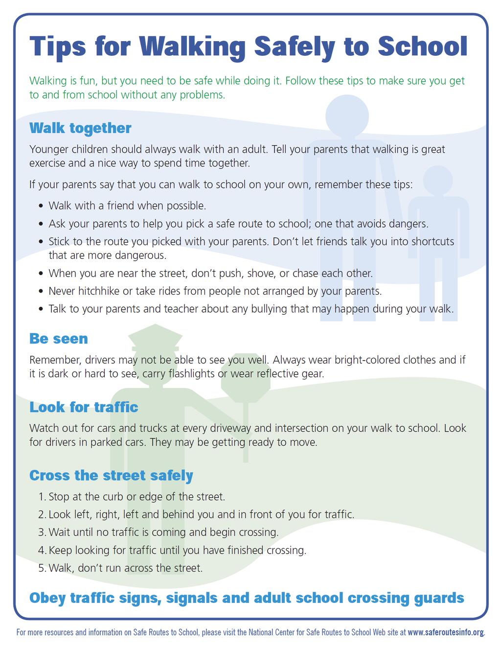
89 89
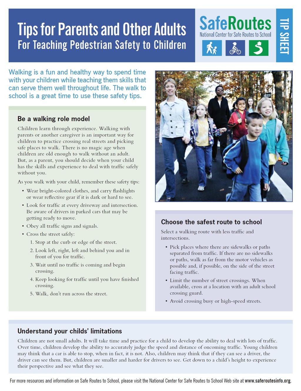
90 90
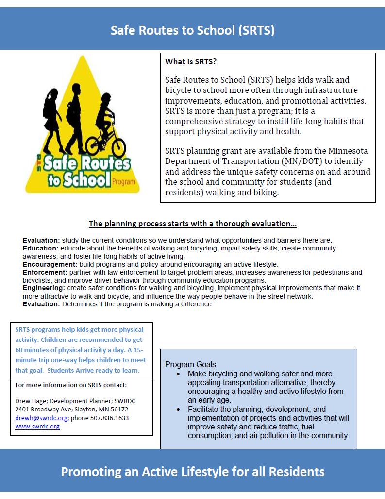
91 91
Bringing together community and health. Physical Activity and Nutrition Unit Office of Statewide Health Improvement Initiatives
 Bringing together community and health. Physical Activity and Nutrition Unit Office of Statewide Health Improvement Initiatives Physical Activity and Nutrition Unit Office of Statewide Health Improvement
SAFE ROUTES TO SCHOOL
 SAFE ROUTES TO SCHOOL Edgewood Elementary School Existing Conditions and ACTION PLAN > Oak Creek - Franklin Joint School District Table of Contents CONTEXT Enrollment Boundaries Enrollment
SAFE ROUTES TO SCHOOL
 SAFE ROUTES TO SCHOOL Forest Ridge Elementary School Existing Conditions and ACTION PLAN > Oak Creek - Franklin Joint School District Table of Contents CONTEXT Enrollment Boundaries
CITY OF OAK CREEK SAFE ROUTES TO SCHOOL ACTION PLAN. East Middle School
 CITY OF OAK CREEK SAFE ROUTES TO SCHOOL ACTION PLAN East Middle School CITY OF OAK CREEK SAFE ROUTES TO SCHOOL ACTION PLAN East Middle School Why Safe Routes to School? Safe Routes to School ( SRTS ) is
July 5, Arthur R. Ware, Jr. Elementary School 2017 Safe Routes to School Walkabout Report
 July 5, 2017 Arthur R. Ware, Jr. Elementary School 2017 Safe Routes to School Walkabout Report 1 Walkabout Report Introduction On April 28, 2017, City, School, and SAWMPO staff met to conduct a Safe Routes
Safe Routes to School Comprehensive Plan
 Safe Routes to School Comprehensive Plan City of Apple Valley Dakota County, MN May 2010 Prepared by: Project Background The Statewide Health Improvement Program (SHIP) aims to help Minnesotans live longer,
AGENDA. 5. Next Steps a. Survey Distribution b. Draft Action Plan/Recommendations c. Review at next meeting in advance of document preparation
 Congdon Elementary Safe Routes to School Plan Update SRTS Team Meeting #2-Walk Audit March 21, 2018, 3:00 p.m. Congdon Elementary School Art Room-Duluth, MN 1. Welcome and Introductions 2. SRTS Review
Chapter 5. Complete Streets and Walkable Communities.
 Chapter 5. Complete Streets and Walkable Communities. 5.1 Description of Complete Streets. Cities throughout the world, and specifically the United States, are coming to embrace a new transportation and
C/CAG. Sunnybrae Elementary School Walking and Bicycling Audit. San Mateo-Foster City School District JUNE 2013
 Sunnybrae Elementary School Walking and Bicycling Audit JUNE 2013 San Mateo-Foster City School District C/CAG City/County Association of Governments of San Mateo County SUNNYBRAE ELEMENTARY SCHOOL WALKING
Why Zone In on Speed Reduction?
 Learn it. Do it. Live it! SPEED REDUCTION IN THE ZONE Why Zone In on Speed Reduction? Speeding is a serious issue that plays a major role in the risk of serious injury and pedestrian fatality in a crash.
Aitkin School Routing Plan July 2010
 Aitkin School Routing Plan July 2010 Prepared by: Arrowhead Regional Development Commission Regional Planning Division Aitkin School Routing Plan July 2010 Aitkin School Routing Plan July 2010 Prepared
Safe Routes to School Comprehensive Plan
 Safe Routes to School Comprehensive Plan City of Rosemount Dakota County, MN June 2010 Prepared by: Project Background The Statewide Health Improvement Program (SHIP) aims to help Minnesotans live longer,
SCHOOL CROSSING PROTECTION CRITERIA
 CITY OF MADISON TRAFFIC ENGINEERING SCHOOL CROSSING PROTECTION CRITERIA January 2016 Adopted as Policy on August 31, 1976, by Common Council by Amended Resolution #29,540 Amended on September 14, 1976,
Safe Routes to School PLAN
 CONGDON ELEMENTARY Safe Routes to School PLAN SRTS Team Kick-off Meeting February 8, 2018 AGENDA Welcome and Introductions Safe Routes to School Program Overview History of SRTS work at Congdon Elementary
EXECUTIVE SUMMARY. Vision
 Vision Walking and bicycling in Salt Lake City will be safe, convenient, comfortable, and viable transportation options that connect people to places, foster recreational and economic development opportunities,
Introduction.
 2307-1.0. Introduction. Delaware s Safe Routes to School (SRTS) Program was established September 10, 2002 when Governor Ruth Ann Minner signed Senate Bill 353 of the 141st General Assembly of Delaware
Montana Safe Routes to School. Encouraging Active Lifestyles
 Montana Safe Routes to School Encouraging Active Lifestyles SRTS Coordinator Taylor Lonsdale, PE taylor.lonsdale@coe.montana.edu (406) 994-7031 Call me! It s my job to help you. The need for Safe Routes
Traffic Impact Memorandum. May 22, 2018
 BISHOP PROFESSIONAL DEVELOPMENT BUILDING Proposed Land-use Change & Parking Modification 3601 SW 31st Street Topeka, Kansas 66614 CFS Project No. 185077 Traffic Impact Memorandum May 22, 2018 Prepared
NEIGHBORHOOD TRAFFIC CALMING POLICY
 NEIGHBORHOOD TRAFFIC CALMING POLICY I. PURPOSE The City of Kent continually strives to strengthen and protect its neighborhoods by improving the quality of life in residential areas. Traffic conditions
Caltrans Sloat Boulevard Pedestrian Safety Project Response to Community Questions, Comments & Concerns
 Caltrans Sloat Boulevard Pedestrian Safety Project Response to Community Questions, Comments & Concerns Revised: May 10, 2016 The California Department of Transportation (Caltrans) is planning various
Safe Routes to School Guide
 Safe Routes to School Guide Steps to Creating a Safe Routes to School Program Created February 2007 SafeRoutes National Center for Safe Routes to School This guide was developed by the Pedestrian and Bicycle
Woodward Hill Elementary School School Safety and Operation Review
 Address: 6082-142 nd Street Surrey, BC, V3X 1C1 Site Visit: March 7, 2011 Principal Anne Mackie Report Date: November 25, 2011 Phone: (604) 594-2408 Email: Mackie_A@sd36.bc.ca The following report is one
Summary Report School Walking & Bicycling Audits. Mesa County Regional Transportation Planning Office
 Summary Report School Walking & Bicycling Audits Mesa County Regional Transportation Planning Office This page left blank intentionally WALKING & BICYCLING AUDIT SUMMARY 2 Executive Summary Background:
GRAHAM PEDESTRIAN TRANSPORTATION PLAN
 GRAHAM PEDESTRIAN TRANSPORTATION PLAN Chapter 1 I 1.1 Scope and Purpose n March of 2005, the City of Graham contracted with Greenways Incorporated (GWI) to create a Pedestrian Transportation Plan. The
Implementing the Three Es of School Zone Traffic Calming
 Implementing the Three Es of School Zone Traffic Calming Use this evaluation tool as a guide to analyze the specific safety needs of your school. SCHOOL PROFILE School Name: School District: Address: Phone
Chapter 2. Bellingham Bicycle Master Plan Chapter 2: Policies and Actions
 Chapter 2 Bellingham Bicycle Master Plan Chapter 2: Policies and Actions Chapter 2: Policies and Actions The Bicycle Master Plan provides a road map for making bicycling in Bellingham a viable transportation
Safe Routes to School in New Jersey
 Safe Routes to School in New Jersey The need for Safe Routes to School 1. Fewer kids today walk and bike to school 2. Unintended consequences have resulted 3. SRTS programs can be part of the solution
SAFE ROUTES TO SCHOOL (SR2S)
") SAFE ROUTES TO SCHOOL (SR2S) In partnership with Burbank Unified School District (BUSD) & City of Burbank George Washington Elementary School Thomas Jefferson Elementary School John Muir Middle School
SAFE ROUTES TO SCHOOL (SR2S) In partnership with Burbank Unified School District (BUSD) & City of Burbank George Washington Elementary School Thomas Jefferson Elementary School John Muir Middle School
Safe Routes to School Action Plan Aberdeen, Idaho
 Background Aberdeen, Idaho is a largely agricultural community of nearly 2,000 people and is located in the southeast portion of the state on the western edge of American Falls Reservoir. The community
Streets. Safe for Pedestrians 20% 2nd 5,000. Are We People-Friendly?
 Streets Safe for Pedestrians 20% Pedestrian deaths account for more than of all traffic-related fatalities in California each year. 600 More than people are killed and another 13,000 are injured every
Chapter 3.3 Horizon Elementary School. Volusia County MPO. June 2009
 Chapter 3.3 Horizon Elementary School Port Orange, FL Volusia County MPO June 2009 Volusia County MPO School Bicycle and Pedestrian Review Study, Phase 3C School Summary Horizon Elementary School is located
Safe Routes to School Grant Application Phase I March 2014
 Safe Routes to School Grant Application Phase I March 2014 Page 1 The City of Mission is requesting grant funding to create a Safe Routes to School Plan which will encompass all of the existing elementary
MARKET/JFK VISION ZERO PILOT PROJECT FEBRUARY 2019 EVALUATION REPORT
 MARKET/JFK VISION ZERO PILOT PROJECT FEBRUARY 2019 EVALUATION REPORT WHY IS THIS PROJECT IMPORTANT? Market Street and JFK Boulevard in Center City are key east-west corridors in the core business district.
Safe Routes to School Travel Plan 2011 Reading-Fleming Intermediate School (RFIS)
") Safe Routes to School Travel Plan 0 Reading-Fleming Intermediate School (RFIS) Reading Fleming Intermediate School 50 Court Street Flemington, NJ 088 Grades: 5-6 Introduction Reading-Fleming Intermediate
Safe Routes to School Travel Plan 0 Reading-Fleming Intermediate School (RFIS) Reading Fleming Intermediate School 50 Court Street Flemington, NJ 088 Grades: 5-6 Introduction Reading-Fleming Intermediate
RESOLUTION NO ?? A RESOLUTION OF THE CITY OF NEPTUNE BEACH ADOPTING A COMPLETE STREETS POLICY
 RESOLUTION NO. 2018-?? A RESOLUTION OF THE CITY OF NEPTUNE BEACH ADOPTING A COMPLETE STREETS POLICY WHEREAS, safe, convenient, and accessible transportation for all users is a priority of the City of Neptune
Sardis Elementary School Road Safety Plan. Produced by: Sardis Elementary School - Safer School Travel Team in cooperation with Safer City
 Sardis Elementary Road Safety Plan Produced by: Sardis Elementary - Safer Travel Team in cooperation with Safer City Plan completed in January 2016 1 Acknowledgements It takes commitment and community
Wellington Exempted Village School District SAFE ROUTES TO SCHOOL TRAVEL PLAN January 2014
 Wellington Exempted Village School District SAFE ROUTES TO SCHOOL TRAVEL PLAN January 2014 OHIO SAFE ROUTES TO SCHOOL WELLINGTON EXEMPTED VILLAGE SCHOOL DISTRICT TRAVEL PLAN SECTION 1: WELLINGTON EXEMPTED
Safety and Active Transport. Dr. Maureen Carew, Medical Officer of Health Renfrew County and District Health Unit May 30, 2014
 Safety and Active Transport Dr. Maureen Carew, Medical Officer of Health Renfrew County and District Health Unit May 30, 2014 Active Transport Vision Increase levels of walking and cycling Reduce vehicle
Welcome! San Jose Avenue Open House August 25, 2015
 Welcome! San Jose Avenue Open House August 25, 2015 Vision Zero The City and County of San Francisco adopted Vision Zero San Francisco Vision Zero High Injury Network as a policy in 2014, committing an
2 Mark Twain Elementary School Report
 2 Mark Twain Elementary School Report Principal: Greg Kaatz Grades: K-2 Enrollment: 323 Address: 425 N. Church Street First bell: 8:10 a.m. Silverton, OR 97381 Last bell: 2:30 p.m. Free & Reduced Lunch:
Getting Your SRTS Project Funded. Ryan Snyder
 Getting Your SRTS Project Funded Ryan Snyder Steps in Submitting a Successful Application 1. Stakeholder outreach: create a SRTS coalition 2. Develop a comprehensive plan and program with all 5 Es 3. Conceive
OCEAN DRIVE ELEMENTARY SCHOOL
 OCEAN DRIVE ELEMENTARY SCHOOL North Myrtle Beach, SC Safe Routes to School Travel Plan JANUARY 2017 SRTS Team Roster SRTS Team members represent key community stakeholders, share work of developing the
Bikeway action plan. Bicycle Friendly Community Workshop March 5, 2007 Rochester, MN
 Bikeway action plan Summary The was held on March 5, 2007 at the Rochester Mayo Civic Center. The workshop was hosted by Rochester-Olmsted County Planning Department in collaboration with the League of
City of Coronado Bicycle Map, Schools, Traffic Signals and Crossing Guard Locations
 City of Coronado Bicycle Map, Schools, Traffic Signals and Crossing Guard Locations Early Childhood Development Center Crossing Guard - AM Crossing Guard - PM Coronado Middle Village Elementary Coronado
TOWN OF PORTLAND, CONNECTICUT COMPLETE STREETS POLICY
 TOWN OF PORTLAND, CONNECTICUT COMPLETE STREETS POLICY I. VISION, GOALS & PRINCIPLES VISION To improve the streets of Portland making them safer and more accessible for all users including pedestrians,
PEDESTRIAN ACTION PLAN
 ATTACHMENT 2 CITY OF SANTA MONICA PEDESTRIAN ACTION PLAN CITY OF SANTA MONICA PEDESTRIAN ACTION PLAN This page intentionally left blank EXECUTIVE SUMMARY CHAPTER 1 EXECUTIVE SUMMARY Setting the Stage
SAFETY GUIDE FOR SCHOOL CHILDREN & PARENTS. toronto.ca/visionzeroto #VisionZeroTO
 SAFETY GUIDE FOR SCHOOL CHILDREN & PARENTS toronto.ca/visionzeroto #VisionZeroTO VISION ZERO ROAD SAFETY PLAN Toronto s Vision Zero Road Safety Plan is a five-year strategy for eliminating traffic-related
TWO HARBORS WALKABLE COMMUNITY REPORT
 TWO HARBORS WALKABLE COMMUNITY REPORT Table of Contents Section 1: Background and Purpose...1 Section 2: Workshop Recommendations...4 Section 3: Action Items...8 This project was made possible through
Speed Limits Study and Proposal. Public Input Session: 8/14/13
 Speed Limits Study and Proposal Public Input Session: 8/14/13 Why is Decatur a unique place for this project? First Community Transportation Plan in the nation with a Health Impact Assessment. Strong sense
Safe Routes to School
 Safe Routes to School Amy Paxton-Aiken, Center TRT University of North Carolina Chapel Hill, NC and Ian Thomas, Executive Director PedNet Coalition Columbia, MO Housekeeping If you are calling in on a
SECTION 1 - CONTACT INFORMATION
 SECTION 1 - CONTACT INFORMATION Please complete the information below. The person identified as the Project Contact Person will be the primary point of contact for Georgia DOT staff. Organization: (Please
Hedgepeth Williams Middle School and Paul Robeson Elementary School Trenton, NJ. School Travel Plan
 Hedgepeth Williams Middle School and Paul Robeson Elementary School Trenton, NJ School Travel Plan Hedgepeth Williams Middle School Description: Hedgepeth-Williams Middle School is located at 301 Gladstone
S A F E R O U T E S T O S C H O O L H E R M A N TOW N S C H O O L S A N D P R O C TO R S C H O O L S P L A N A P P R OVA L S
 S A F E R O U T E S T O S C H O O L H E R M A N TOW N S C H O O L S A N D P R O C TO R S C H O O L S P L A N A P P R OVA L S WHAT IS SAFE ROUTES TO SCHOOL? In 1969, nearly 50% of children walked or rode
Safe Routes to School Blue Zones Project, City of
 Safe Routes to School Blue Zones Project, City of Fort Worth and FWISD Partnership Introduction to Blue Zones Project Blue ZonesProject is a well-being improvement initiative designed to make healthy choices
AGENDA REPORT. Issue: Discussion of potential improvements on Barnwell Road at Niblick Drive
 AGENDA REPORT To: From: By: Honorable Mayor and City Council Members Warren Hutmacher, City Manager Tom Black, Public Works Director Date: March 23, 2016 Agenda: March 28, 2016 WORK SESSION AGENDA: Barnwell
Rim Rock Elementary School Walking and Biking Audit
 Rim Rock Elementary School Walking and Biking Audit September 29, 2016 Rim Rock Elementary School Audit for Walking and Biking September 29, 2016 Audit Team Members: Sam Atkins, City Engineer, City of
Public Information Centre
 WELCOME Public Information Centre Father Tobin Road Lougheed Middle School - Library Wednesday November 7, 2012 7:00 p.m.to 9:00 p.m. Please sign in Neighbourhood Traffic Calming Guide Background The City
Chapter 3.9 Timbercrest Elementary School. Volusia County MPO. November 2008
 Chapter 3.9 Timbercrest Elementary School Deltona, FL Volusia County MPO November 2008 Volusia County MPO School Bicycle and Pedestrian Review Study, Phase 3B School Summary Timbercrest Elementary School
Sebastopol Charter School Traffic Management Plan
 Sebastopol Charter School The serves as the working document in support of these essential goals: to ensure the safety and efficiency of student arrival to and departure from school to ensure the safety
Chapter 4.3 Enterprise Elementary. Volusia County MPO. March Page 7.0
 Chapter 4.3 Enterprise Elementary Enterprise, FL Volusia County MPO March 2008 Page 7.0 Volusia County MPO Bicycle and Pedestrian School Safety Review Study Introduction Enterprise Elementary School is
Safe and Active Routes to School in Cabarrus County
 Safe and Active Routes to School in Cabarrus County In 2014, Cabarrus Health Alliance became the host agency for the Charlotte region s coordinator in the NC Active Routes to School program. The NC-ARTS
THE OFFICIAL GUIDE TO CYCLING SAFELY IN PHILADELPHIA
 B IKE NICE THE OFFICIAL GUIDE TO CYCLING SAFELY IN PHILADELPHIA A partnership of the City of Philadelphia and the Bicycle Coalition of Greater Philadelphia ABOUT VISION ZERO & BIKE NICE It s a great day
PEDALING FORWARD. A Glance at the SFMTA s Bike Program for SFMTA.COM
 PEDALING FORWARD A Glance at the SFMTA s Bike Program for 2017-2021 SFMTA.COM INTRODUCTION About This Booklet More people from all walks of life see their bicycle as a more convenient way to get where
City of Birmingham Draft Multi-modal Transportation Plan
 City of Birmingham Draft Multi-modal Transportation Plan City Commission Public Hearing Monday, November 25, 2013 7:30 pm Norman Cox, PLA, ASLA The Greenway Collaborative, Inc. Ann Arbor, Michigan The
Student Pedestrian Safety Fiddlers Canyon Elementary Community Council 2012
 Student Pedestrian Safety Fiddlers Canyon Elementary Community Council 2012 Introduction Fiddlers Canyon Elementary students must cross North Wedgewood Lane and Fiddlers Canyon Drive in order to come to
CHAPTER 3: Vision Statement and Goals
 Davidson Walks & Rolls: Active Transportation Master Plan CHAPTER 3 Contents: Overview Vision Statement Measurable Goals Public Outreach CHAPTER 3: Vision Statement and Goals Overview The vision statement
Residential Traffic Calming Program Guide. Town of Ashland, Virginia
 Residential Traffic Calming Program Guide Town of Ashland, Virginia August 1, 2006 TABLE OF CONTENTS A. INTRODUCTION... 1 B. GOALS... 1 C. CRITERIA... 1 D. IDENTIFYING NEIGHBORHOOD TRAFFIC CONCERNS...
Prevent Pedestrian Crashes:
 Prevent Pedestrian Crashes: Parents and Caregivers of Elementary School Children Elementary school children are very active and impulsive. Although they are learning and growing, school-age children 10
Vallecito Elementary School. Travel Plan
 Vallecito Elementary School Travel Plan TABLE OF CONTENTS 1. PURPOSE... 1 1.1. SR2S PLANNING, IMPLEMENTATION AND MONITORING... 1 1.2. MARIN COUNTY MEASURE A... 1 2. VALLECITO ELEMENTARY SCHOOL PROFILE...
TRAFFIC ACTION PLAN. North Central Neighborhood CITY OF SAN MATEO
 TRAFFIC ACTION PLAN North Central Neighborhood CITY OF SAN MATEO Draft February 2017 Table of Contents Introduction... 1 The Traffic Forum Process... 4 Neighborhood Traffic Issues... 6 Neighborhood Recommendations
Walkable Communities: National Best Practices and Applications in Memphis, TN
 Walkable Communities: National Best Practices and Applications in Memphis, TN Dr. Stephanie Ivey Assistant Professor Herff College of Engineering Department of Civil Engineering Agenda Walkable communities
Lawrence Safe Routes to School. Community Meeting January 14, 2015
 Lawrence Safe Routes to School Community Meeting January 14, 2015 Safe Routes to School The 6 E s Education Encouragement Enforcement Engineering Evaluation Equity What are the elements of a SRTS plan?
Agenda. Overview PRINCE GEORGE S PLAZA METRO AREA PEDESTRIAN PLAN
 PRINCE GEORGE S PLAZA METRO AREA PEDESTRIAN PLAN May 28, 2008 Agenda Welcome and introductions Project overview and issue identification Planning context and strengths Design challenges and initial recommendations
JONESBORO HIGHWAY 63 HIGHWAY 18 CONNECTOR STUDY
 JONESBORO HIGHWAY 63 HIGHWAY 18 CONNECTOR STUDY Craighead County May 2007 JONESBORO HIGHWAY 63 HIGHWAY 18 CONNECTOR STUDY Craighead County May 2007 Prepared by Planning and Research Division Arkansas State
3 Silverton High School Report
 3 Silverton High School Report Principal: Justin Lieuallen Grades: 9-12 Enrollment: 1,277 Address: 1456 Pine Street First bell: 7:55 a.m. Silverton, OR 97381 Last bell: 3:05 p.m. Free & Reduced Lunch:
Safe Routes to School Travel Plan 2011
 Safe Routes to School Travel Plan 2011 Barley Sheaf Elementary School Barley Sheaf School 80 Barley Sheaf Road Flemington, NJ 08822 Grades: K-4 Introduction Barley Sheaf School is a K-4 elementary school
City of Elizabeth City Neighborhood Traffic Calming Policy and Guidelines
 City of Elizabeth City Neighborhood Traffic Calming Policy and Guidelines I. Purpose: The City of Elizabeth City is committed to ensure the overall safety and livability of residential neighborhoods. One
G AT E WAY PLAN. Community BRIEFING KIT GATEWAY BIKE
 G AT E WAY PLAN GATEWAY BIKE Community BRIEFING KIT PLAN August 2016 TABLE OF CONTENTS INTRODUCTION... 1 THE BENEFITS OF A BIKEABLE COMMUNITY... 2 ECONOMY...2 SAFETY...3 HEALTH...3 HOUSEHOLD SPENDING...3
MASTER BICYCLE AND PEDESTRIAN PLAN
 VILLAGE OF NORTHBROOK MASTER BICYCLE AND PEDESTRIAN PLAN DRAFT PLAN OPEN HOUSE May 2, 2018 AGENDA 1. Community Engagement 2. Vision and Goals 3. General Structure of Plan 4. Recommendations Overview 5.
Toward Zero Deaths. Regional SHSP Road Show Meeting. Virginia Strategic Highway Safety Plan. presented by
 Toward Zero Deaths Regional SHSP Road Show Meeting presented by Virginia Strategic Highway Safety Plan December 1, 2016 1 Welcome & Introductions Purpose of the Meeting Objectives & Key Outcomes Agenda»
SCHOOL CROSSING PROTECTION CRITERIA
 CITY OF MADISON TRAFFIC ENGINEERING SCHOOL CROSSING PROTECTION CRITERIA AUGUST 1990 Adopted as Policy on August 31, 1976, by Common Council by Amended Resolution #29,540 Amended on September 14, 1976,
Film Guide for Educators. Designing for Safety
 Film Guide for Educators Designing for Safety Designing For Safety Key Concepts Speeding While Driving Speeding is the number one cause of injuries and deaths from driving. The main reasons are because
COWETA HIGH SCHOOL AND EAST HIGHWAY 51
 COWETA HIGH SCHOOL AND EAST HIGHWAY 51 Lack of sidewalks along Ben Lumpkin Rd. Lack of crosswalks and ramps at intersection. Hwy 51 is wide to cross as a pedestrian. No ADA compliance or connection to
Borough of Danville, PA Traffic Calming Program Guidelines
 Borough of Danville, PA Traffic Calming Program Guidelines Adopted by Borough Council on 1 INTRODUCTION Speeding Traffic is a major concern in the Borough of Danville because of its detrimental impacts
CHAIR AND MEMBERS CIVIC WORKS COMMITTEE MEETING ON APRIL 25, 2016
 TO: FROM: SUBJECT: CHAIR AND MEMBERS CIVIC WORKS COMMITTEE MEETING ON APRIL 25, 2016 JOHN BRAAM, P. ENG. MANAGING DIRECTOR, ENVIRONMENTAL & ENGINEERING SERVICES AND CITY ENGINEER SCHOOL ZONE SPEED LIMIT
Dear Mayor Murray, Top SR-520 Design Innovations and Remaining Opportunities
 Dear Mayor Murray, Thank you for your leadership building a transportation system that moves people efficiently throughout the region, and creates healthy places to live, work, and play. We are glad you
LTAC: Katie Mencarini, Central & Hampton Roads streets and a fifteen minute debrief to discuss the findings. Participants walked along Mill Road
 Walkabout Summary On June 3, 2013, five participants met at Glen Allen Elementary School in Glen Allen, Virginia to take a closer look at the walking and biking network around the school. In addition to
Corpus Christi Metropolitan Transportation Plan Fiscal Year Introduction:
 Introduction: The Safe, Accountable, Flexible, Efficient Transportation Equity Act: A Legacy for Users (SAFETEA-LU) has continued the efforts started through the Intermodal Surface Transportation Efficiency
Background and Goals of SRTS
 Safe Routes to School Background and Goals of SRTS Oklahoma Kick-off May 4, 2011 The Good, the Bad, and the Ugly Fewer kids are biking and walking More parents are driving 1969 2009 48% walked or biked
WELCOME Public Information Centre
 WELCOME Public Information Centre Fernforest Drive Brampton Soccer Centre Community Room #2 Tuesday January 19, 2016 6:30 p.m.to 9:00 p.m. Please sign in Neighbourhood Traffic Calming Guide Background
Town of Orangetown Neighborhood Traffic Calming Program
 Town of Orangetown Neighborhood Traffic Calming Program Table of Contents I Introduction a. Purpose b. Key to successful projects c. What is Traffic Calming? II III IV V VI VII Definitions Street Classification
City of Novi Non-Motorized Master Plan 2011 Executive Summary
 City of Novi Non-Motorized Master Plan 2011 Executive Summary Prepared by: February 28, 2011 Why Plan? Encouraging healthy, active lifestyles through pathway and sidewalk connectivity has been a focus
AGENDA ITEM NO. 5b HCAOG TAC meeting of May 8, 2014
 Humboldt County Association of Governments Eureka, CA, 95501 AGENDA ITEM NO. 5b HCAOG TAC meeting of May 8, 2014 DATE: May 1, 2014 TO: HCAOG Technical Advisory Committee (TAC) FROM:, SUBJECT: Letters of
CITY OF VISTA TRAFFIC CALMING PROGRAM
 CITY OF VISTA TRAFFIC CALMING PROGRAM The purpose of the Vista Traffic Calming Program is to reduce speeds of motorists driving through residential neighborhoods. The program does not apply to nonresidential
AMHERST EXEMPTED VILLAGE SCHOOLS AND SAINT JOSEPH SCHOOL
 AMHERST EXEMPTED VILLAGE SCHOOLS AND SAINT JOSEPH SCHOOL SAFE ROUTES TO SCHOOL TRAVEL PLAN 12/11/18 DRAFT OHIO SAFE ROUTES TO SCHOOL SCHOOL TRAVEL PLAN Ohio s Safe Routes to School Travel Plan Template
Safe Routes to School NELLIE STONE JOHNSON COMMUNITY SCHOOL
 December 2010 Safe Routes to School NELLIE STONE JOHNSON COMMUNITY SCHOOL Encouraging walking and biking to school Safe Routes to School: Healthy Kids Focused Students Across the nation, communities are
Franklin Parking Analysis
 Franklin Parking Analysis Report Prepared for: The Town of Franklin, North Carolina Report prepared by: 525 N. Main Street Waynesville, NC 28786 Town of Franklin Parking Study J.M. Teague Engineering 1
Table of Contents Introduction. 2 Purpose of the Plan...2 The Benefits of Walking and Bicycling...3 Vision and Goals of the Plan...
 BICYCLE AND This plan was created through a grant from the Healthy Communities Program with the cooperation of the City of Cynthiana, Cynthiana Main Street, Cynthiana-Harrison County-Berry Joint Planning
Orange Center Elementary School
 Drag and drop pic and stretch/crop to the limits of the blue rectangle (delete this text box) Orange Center Elementary School Drag and drop pic and stretch/crop to the limits of the blue rectangle (delete
About the Studio. Edward J. Bloustein School of Planning and Public Policy - Rutgers University
 About the Studio Edward J. Bloustein School of Planning and Public Policy - Rutgers University Purpose of studio: Help City of Bayonne apply for Safe Routes to School (SRTS) funding by producing a School