Primary Contact. Organization Information. Application Multiuse Trails and Bicycle Facilities
|
|
|
- Owen Wheeler
- 5 years ago
- Views:
Transcription
1 Application Multiuse Trails and Bicycle Facilities West St. Paul Oakdale and Marie Bicycle and Pedestrian Improvements Regional Solicitation - Bicycle and Pedestrian Facilities Status: Submitted Date: Submitted 07/15/2016 1:59 PM Primary Contact Name:* Title: Department: Address: Benjamin Arthur Boike Salutation First Name Middle Name Last Name Assistant Community Development Director/City Planner Community Development bboike@wspmn.gov 1616 Humboldt Ave * West St. Paul Minnesota City State/Province Postal Code/Zip Phone:* Fax: Phone Ext. What Grant Programs are you most interested in? Regional Solicitation - Bicycle and Pedestrian Facilities Organization Information Name: WEST ST PAUL, CITY OF Jurisdictional Agency (if different):
2 Organization Type: City Organization Website: Address: 1616 Humboldt Ave * County: West St Paul Minnesota City State/Province Postal Code/Zip Ramsey Phone:* Fax: PeopleSoft Vendor Number A1 Ext. Project Information Project Name Primary County where the Project is Located West St. Paul Oakdale and Marie Trail Extension` Dakota Jurisdictional Agency (If Different than the Applicant):
3 Brief Project Description (Limit 2,800 characters; approximately 400 words) The Oakdale and Marie Trail Extension will expand the non-motorized transportation network for the City of West St. Paul in northern Dakota County. The project will construct 10-foot bituminous trails for nearly one mile on the east side of Oakdale Avenue (CSAH 73) from Mendota Road to Wentworth Avenue (CSAH 8) and for 0.5 miles on the south side of Marie Avenue from Robert Street (TH 3) to Oakdale Avenue (CSAH 73). In addition, streetscape improvements, including a 6-foot sidewalk on the north side of Marie Avenue, pedestrian-scale lighting, vegetation, high-visibility crossings and wayfinding, are part of this project to create a safe and pleasant experience for pedestrians and bicyclists. These improvements will contribute significantly to the City?s surface transportation network. Currently there are no off-road facilities on either street. Pedestrians and bicyclists, including those using transit, need to use the street in order to reach their destination. Despite the lack of facilities, annual counts show Oakdale and Marie Avenues are already being used as non-motorized transportation routes counts found over 295,000 pedestrians and 24,000 bicyclists annually on Oakdale Avenue (CSAH 73) and 92,000 pedestrians and 12,000 bicyclists on Marie Avenue. The Oakdale and Marie Trail Extension addresses a need identified in local and county plans regarding enhanced pedestrian and bicycle connectivity. The City?s Pedestrian and Bicycle Master Plan completed in 2011 identified both connections as critical elements of the city-wide non-motorized transportation framework. The study completed for the Robert Street Improvement Project currently underway found that the trail gap on Marie is a high priority to address to support Robert Street?s transformation to a pedestrianoriented district. In 2015 the Marie Avenue & Oakdale Avenue (CSAH 73) Pedestrian & Bicycle Infrastructure Feasibility Study was completed for
4 the area, and the multi-use trail facilities on Oakdale Avenue and Marie Avenue were given highest priority in the area. Local, county, and regional plans have all identified Oakdale Avenue (CSAH 73) as a bicycle route for northern Dakota County. In addition to using Oakdale to reach St. Paul, trail users on Oakdale Avenue (CSAH 73) will be able to connect with the River to River Greenway at Wentworth Avenue (CSAH 8). This is one of 8 regional greenways in Dakota County that connect to the greater regional trail system of St. Paul and Minneapolis. While commuters will be able to reach employment centers in other communities, recreational users will be able to travel east to Thompson County Park, Kaposia Park, and the Mississippi River Trail, and west to Mendota Heights, Lilydale, historic Mendota, and the Minnesota River. Include location, road name/functional class, type of improvement, etc. TIP Description Guidance (will be used in TIP if the project is selected for funding) Oakdale Avenue (CSAH 63) and Marie Avenue, West St. Paul, Oakdale from Mendota Road to Wentworth and Marie from Robert Street to Oakdale, Construct Bituminous Trail, Pedestrian Ramps, Crosswalks Project Length (Miles) 1.6 Project Funding Are you applying for funds from another source(s) to implement this project? No If yes, please identify the source(s) Federal Amount $1,195, Match Amount $298, Minimum of 20% of project total Project Total $1,494, Match Percentage 20.0% Minimum of 20% Compute the match percentage by dividing the match amount by the project total Source of Match Funds Dakota County and City of West St. Paul
5 A minimum of 20% of the total project cost must come from non-federal sources; additional match funds over the 20% minimum can come from other federal sources Preferred Program Year Select one: 2020 For TDM projects, select 2018 or For Roadway, Transit, or Trail/Pedestrian projects, select 2020 or Additional Program Years: 2019 Select all years that are feasible if funding in an earlier year becomes available. Project Information County, City, or Lead Agency City of West St. Paul Zip Code where Majority of Work is Being Performed (Approximate) Begin Construction Date 07/01/2020 (Approximate) End Construction Date 11/01/2021 Name of Trail/Ped Facility: West St. Paul Oakdale and Marie Trail Extension (i.e., CEDAR LAKE TRAIL) TERMINI:(Termini listed must be within 0.3 miles of any work) From: (Intersection or Address) To: (Intersection or Address) Oakdale Avenue (CSAH 73) & Mendota Road E (CSAH 14) AND FROM Marie Avenue E & Oakdale Avenue (CSAH Oakdale Avenue (CSAH 73) & Wentworth Avenue E (CSAH 8) AND TO Marie Avenue E & Robert Street S DO NOT INCLUDE LEGAL DESCRIPTION; INCLUDE NAME OF ROADWAY IF MAJORITY OF FACILITY RUNS ADJACENT TO A SINGLE CORRIDOR Or At: Primary Types of Work Grade, Aggregate Base, Bituminous Base, Bituminous Surface, Multi-use trail, Pedestrian Ramps, Pedestrian-Scale Lighting, Streetscaping Examples: GRADE, AGG BASE, BIT BASE, BIT SURF, SIDEWALK, SIGNALS, LIGHTING, GUARDRAIL, BIKE PATH, PED RAMPS, BRIDGE, PARK AND RIDE, ETC. BRIDGE/CULVERT PROJECTS (IF APPLICABLE) Old Bridge/Culvert No.: New Bridge/Culvert No.: Structure is Over/Under (Bridge or culvert name): N/A N/A N/A Specific Roadway Elements CONSTRUCTION PROJECT ELEMENTS/COST ESTIMATES Cost Mobilization (approx. 5% of total cost) $52,000.00
6 Removals (approx. 5% of total cost) $72, Roadway (grading, borrow, etc.) $0.00 Roadway (aggregates and paving) $0.00 Subgrade Correction (muck) $0.00 Storm Sewer $0.00 Ponds $0.00 Concrete Items (curb & gutter, sidewalks, median barriers) $0.00 Traffic Control $31, Striping $0.00 Signing $7, Lighting $0.00 Turf - Erosion & Landscaping $31, Bridge $0.00 Retaining Walls $0.00 Noise Wall (do not include in cost effectiveness measure) $0.00 Traffic Signals $0.00 Wetland Mitigation $0.00 Other Natural and Cultural Resource Protection $0.00 RR Crossing $0.00 Roadway Contingencies $0.00 Other Roadway Elements $319, Totals $513, Specific Bicycle and Pedestrian Elements CONSTRUCTION PROJECT ELEMENTS/COST ESTIMATES Cost Path/Trail Construction $706, Sidewalk Construction $0.00 On-Street Bicycle Facility Construction $0.00 Right-of-Way $0.00 Pedestrian Curb Ramps (ADA) $28, Crossing Aids (e.g., Audible Pedestrian Signals, HAWK) $0.00 Pedestrian-scale Lighting $0.00 Streetscaping $0.00 Wayfinding $0.00
7 Bicycle and Pedestrian Contingencies $247, Other Bicycle and Pedestrian Elements $0.00 Totals $981, Specific Transit and TDM Elements CONSTRUCTION PROJECT ELEMENTS/COST ESTIMATES Cost Fixed Guideway Elements $0.00 Stations, Stops, and Terminals $0.00 Support Facilities $0.00 Transit Systems (e.g. communications, signals, controls, fare collection, etc.) $0.00 Vehicles $0.00 Contingencies $0.00 Right-of-Way $0.00 Other Transit and TDM Elements $0.00 Totals $0.00 Transit Operating Costs Number of Platform hours 0 Cost Per Platform hour (full loaded Cost) $0.00 Substotal $0.00 Other Costs - Administration, Overhead,etc. $0.00 Totals Total Cost $1,494, Construction Cost Total $1,494, Transit Operating Cost Total $0.00 Requirements - All Projects All Projects 1.The project must be consistent with the goals and policies in these adopted regional plans: Thrive MSP 2040 (2014), the 2040 Transportation Policy Plan, the 2040 Regional Parks Policy Plan (2015), and the 2040 Water Resources Policy Plan (2015). Check the box to indicate that the project meets this requirement.
8 2.The project must be consistent with the 2040 Transportation Policy Plan. Reference the 2040 Transportation Plan objectives and strategies that relate to the project.
9 Goal: Healthy Environment (pg. 66) Objectives: C) Increase the availability and attractiveness of transit, bicycling, and walking to encourage healthy communities and active car-free lifestyles. (pg. 66) D) Provide a transportation system that promotes community cohesion and connectivity for people of all ages and abilities, particularly for historically under represented populations. (pg. 66) List the goals, objectives, strategies, and associated pages: Strategies: 1) Regional transportation partners will plan and implement a transportation system that considers the needs of all potential users, including children, senior citizens, and persons with disabilities, and that promotes active lifestyles and cohesive communities. A special emphasis should be placed on promoting the environmental and health benefits of alternatives to single-occupancy vehicle travel. (pg Goal: Access to Destinations (pg. 62) Objectives: D) Increase transit ridership and the share of trips taken using transit, bicycling and walking. (pg. 62) E) Improve multimodal travel options for people of all ages and abilities to connect to jobs and other opportunities, particularly for historically underrepresented populations. (pg. 62) Goal: Leveraging Transportation Investment to Guide Land Use (pg. 70) Objectives: C - Encourage local land use design that integrates highways, streets, transit, walking, and bicycling. (pg. 70) Strategies: 2) Local governments should include bicycle and pedestrian elements in local comprehensive plans. (pg. 2.15)
10 Goal: Competitive Economy (pg. 64) Objectives: B) Invest in a multimodal transportation system to attract and retain businesses and residents. Strategies: 1) The Council and its transportation partners will identify and pursue the level of increased funding needed to create a multimodal transportation system that is safe, well-maintained, offers modal choices, manages and eases congestion, provides reliable access to jobs and opportunities, facilitates the shipping of freight, connects and enhances communities, and shares benefits and impacts equitably among all communities and users. (pg. 2.11) 2) The Council and its partners will invest in regional transit and bicycle systems that improve connections to jobs and opportunity, promote economic development, and attract and retain businesses and workers in the region on the established transit corridors. (pg. 2.11) (Limit 2500 characters; approximately 750 words) 3.The project or the transportation problem/need that the project addresses must be in a local planning or programming document. Reference the name of the appropriate comprehensive plan, regional/statewide plan, capital improvement program, corridor study document [studies on trunk highway must be approved by the Minnesota Department of Transportation and the Metropolitan Council], or other official plan or program of the applicant agency [includes Safe Routes to School Plans] that the project is included in and/or a transportation problem/need that the project addresses.
11 The WSP Oakdale and Marie Trail Extension Project addresses a need identified in local and county plans regarding enhanced pedestrian and bicycle connectivity. The City of West St. Paul's Comprehensive Plan, adopted in 2010, identifies the need for enhancing the off-street network and increasing the range of transportation options for residents (pg ). The City began working towards the goal by completing a Pedestrian and Bicycle Master Plan in The plan specifically identifies Oakdale and Marie Avenues as critical elements of the city-wide pedestrian and bicycle framework east of the Robert Street corridor and recommends off-road trails or sidewalks for both locations (pg. E 10-13). In addition, the study for the Robert Street Improvement project completed in 2012 found that the trail gap on Marie Avenue is a high priority to address while the Oakdale Avenue gap is a medium priority (pg. 2). List the applicable documents and pages: In addition to West St. Paul, Dakota County's Comprehensive Plan (approved May 2009) identifies a lack of pedestrian and bicycle facilities (especially in urban areas of the county) as a problem. The plan identifies on Page a scenario similar to that of Oakdale Avenue (CSAH 73): -Some urban areas of the County may not see reconstruction of County roads for a long time. Therefore, the County should evaluate which County roads in urban areas lack pedestrian infrastructure and are not scheduled for construction in a satisfactory timeframe to accommodate pedestrians. Since this language was written in 2008, the County has evaluated pedestrian and bicyclist demand and gaps in the system, as mentioned in the previous excerpt; Oakdale Avenue (CSAH 73) emerged as a priority location. The County's Comprehensive Plan also discusses the need to provide places in the County where people can live without relying on a private
12 automobile (pages , , , and elsewhere). The County?s Comprehensive Plan offers rationale for improving its non-motorized transportation infrastructure including sustainability, social equity, increasing regular physical activity, increasing number of non-driving trips and quality of life on pages and (Limit 2500 characters; approximately 750 words) 4.The project must exclude costs for studies, preliminary engineering, design, or construction engineering. Right-of-way costs are only eligible as part of bicycle/pedestrian projects, transit stations/stops, transit terminals, park-and-ride facilities, or pool-and-ride lots. Noise barriers, drainage projects, fences, landscaping, etc., are not eligible for funding as a standalone project, but can be included as part of the larger submitted project, which is otherwise eligible. Check the box to indicate that the project meets this requirement. 5.Applicants that are not cities or counties in the seven-county metro area with populations over 5,000 must contact the MnDOT Metro State Aid Office prior to submitting their application to determine if a public agency sponsor is required. Check the box to indicate that the project meets this requirement. 6.Applicants must not submit an application for the same project in more than one funding sub-category. Check the box to indicate that the project meets this requirement. 7.The requested funding amount must be more than or equal to the minimum award and less than or equal to the maximum award. The cost of preparing a project for funding authorization can be substantial. For that reason, minimum federal amounts apply. Other federal funds may be combined with the requested funds for projects exceeding the maximum award, but the source(s) must be identified in the application. Funding amounts by application category are listed below. Multiuse Trails and Bicycle Facilities: $250,000 to $5,500,000 Pedestrian Facilities (Sidewalks, Streetscaping, and ADA): $250,000 to $1,000,000 Safe Routes to School: $150,000 to $1,000,000 Check the box to indicate that the project meets this requirement. 8.The project must comply with the Americans with Disabilities Act. Check the box to indicate that the project meets this requirement. 9.The project must be accessible and open to the general public. Check the box to indicate that the project meets this requirement. 10.The owner/operator of the facility must operate and maintain the project for the useful life of the improvement. Check the box to indicate that the project meets this requirement. 11.The project must represent a permanent improvement with independent utility. The term independent utility means the project provides benefits described in the application by itself and does not depend on any construction elements of the project being funded from other sources outside the regional solicitation, excluding the required non-federal match. Projects that include traffic management or transit operating funds as part of a construction project are exempt from this policy. Check the box to indicate that the project meets this requirement. 12.The project must not be a temporary construction project. A temporary construction project is defined as work that must be replaced within five years and is ineligible for funding. The project must also not be staged construction where the project will be replaced as part of future stages. Staged construction is eligible for funding as long as future stages build on, rather than replace, previous work. Check the box to indicate that the project meets this requirement.
13 13.The project applicant must send written notification regarding the proposed project to all affected state and local units of government prior to submitting the application. Check the box to indicate that the project meets this requirement. Requirements - Bicycle and Pedestrian Facilities Projects 1.All projects must relate to surface transportation. As an example, for multiuse trail and bicycle facilities, surface transportation is defined as primarily serving a commuting purpose and/or that connect two destination points. A facility may serve both a transportation purpose and a recreational purpose; a facility that connects people to recreational destinations may be considered to have a transportation purpose. Check the box to indicate that the project meets this requirement. Multiuse Trails on Active Railroad Right-of-Way: 2.All multiuse trail projects that are located within right-of-way occupied by an active railroad must attach an agreement with the railroad that this right-of-way will be used for trail purposes. Check the box to indicate that the project meets this requirement. Safe Routes to School projects only: 3.All projects must be located within a two-mile radius of the associated primary, middle, or high school site. Check the box to indicate that the project meets this requirement. 4.All schools benefitting from the SRTS program must conduct after-implementation surveys. These include the student travel tally form and the parent survey available on the National Center for SRTS website. The school(s) must submit the after-evaluation data to the National Center for SRTS within a year of the project completion date. Additional guidance regarding evaluation can be found at the MnDOT SRTS website. Check the box to indicate that the applicant understands this requirement and will submit data to the National Center for SRTS within one year of project completion. Requirements - Bicycle and Pedestrian Facilities Projects Measure A: Project Location Relative to the RBTN Select one: Tier 1, Priority RBTN Corridor Tier 1, RBTN Alignment Tier 2, RBTN Corridor Tier 2, RBTN Alignment Direct connection to an RBTN Tier 1 corridor or alignment Direct connection to an RBTN Tier 2 corridor or alignment OR Project is not located on or directly connected to the RBTN, but is part of a local system and identified within an adopted county, city or regional parks implementing agency plan. Upload Map _MarieOakdale_OVERVIEW_RBTN.pdf
14 Measure A: Population Summary Existing Population Within One Mile (Integer Only) Existing Employment Within One Mile (Integer Only) Upload the "Population Summary" map _MarieOakdale_OVERVIEW_POP.pdf Measure A: Project Location and Impact to Disadvantaged Populations Select one: Project located in Area of Concentrated Poverty with 50% or more of residents are people of color (ACP50): Project located in Area of Concentrated Poverty: Projects census tracts are above the regional average for population in poverty or population of color: Project located in a census tract that is below the regional average for population in poverty or populations of color or includes children, people with disabilities, or the elderly:
15 The WSP Oakdale and Marie Trail Extension Project is located in an area of concentrated poverty, as seen in the?socio-econ? map. Lowincome populations are more likely to need alternatives to personal vehicle transportation. Currently, neither Oakdale nor Marie Avenues have off-street facilities for non-motorized users. This project proposes to positively benefit the community by adding off-street multi-use trails to serve bicyclists and pedestrians as well as provide off-street waiting areas and connections for transit users. Response (Limit 2,800 characters; approximately 400 words) The characteristics of residents and employees in the area serve to drive demand for non-motorized transportation alternatives. According to 2008 Local Employment Dynamics data from DEED, 32% percent of jobs pay and 24% of residents earn less than $14,400 annually in the area bounded by Robert Street (TH 3), TH 52, Thompson Avenue and Mendota Road (Oakdale is at its center). This contrasts to 24% of metro area jobs and 19% of metro area residents. Lower-income workers and residents are more dependent on transit and nonmotorized transportation, making improvements along Oakdale and Marie Avenues is key to serving these populations. The response should address the benefits, impacts, and mitigation for the populations affected by the project. The project will also provide a much needed connection for underserved populations, such as children, the elderly, and disabled populations, by providing safe, off-street facilities that connect to transit and community facilities such as the West St. Paul Sports Complex and the commercial centers of Marie Avenue and Robert Street. Upload Map _MarieOakdale_OVERVIEW_SE.pdf Measure B: Affordable Housing
16 City/Township Segment Length in Miles (Population) West St. Paul Total Project Length Total Project Length (Total Population) 1.6 Affordable Housing Scoring - To Be Completed By Metropolitan Council Staff City/Township Segment Length (Miles) Total Length (Miles) Score Segment Length/Total Length Housing Score Multiplied by Segment percent Affordable Housing Scoring - To Be Completed By Metropolitan Council Staff Total Project Length (Miles) 1.6 Total Housing Score 0 Measure A: Gaps, Barriers and Continuity/Connections Check all that apply: Gap improvements can be on or off the RBTN and may include the following: Providing a missing link between existing or improved segments of a regional (i.e., RBTN) or local transportation network; Improving bikeability to better serve all ability and experience levels by: Providing a safer, more protected on-street facility; Improving crossings at busy intersections (signals, signage, pavement markings); OR Improving a bike route or providing a trail parallel to a highway or arterial roadway along a lower-volume neighborhood collector or local street. Barrier crossing improvements (on or off the RBTN) can include crossings (over or under) of rivers or streams, railroad corridors, freeways, or multi-lane highways, or enhanced routes to circumvent the barrier by channeling bicyclists to existing safe crossings or grade separations. (For new barrier crossing projects, data about the nearest parallel crossing (as described above) must be included in the application to be considered for the full allotment of points under this criterion). Closes a transportation network gap and/or provides a facility that crosses or circumvents a physical barrier Improves continuity and/or connections between jurisdictions (on or off the RBTN) (e.g., extending a specific bikeway facility treatment across jurisdictions to improve consistency and inherent bikeability) Improves Continuity and/or Connections Between Jurisdictions
17 The proposed Oakdale and Marie Trail Extension Project provides a Critical Bicycle Transportation Link addressing gaps types identified in the 2040 Transportation Policy Plan and connecting communities. The project will eliminate a gap in the Tier 1 RBTN by building a safe, off-street multi-use trail that connects users to the commercial and employment areas along the Robert Street Corridor, as well as to downtown and West Side St. Paul. Oakdale has been identified as a priority north-south bicycle route since Robert Street (TH 3) is unable to accommodate bicyclists safely. Response (Limit 2,800 characters; approximately 400 words) The project will provide off-street trail access for bicyclists and pedestrians along Marie and Oakdale, neither of which currently has any facilities. The project will provide greater regional connectivity through its connection at Oakdale and Wentworth to the River to River Greenway, one of Dakota County?s eight regional greenways that extends east-west from Lilydale to South St. Paul. Oakdale Avenue has one lane in each direction, a middle turning lane, and shoulders on each side. The speed limit along the project area is 35 mph. The average daily traffic count in 2012 for Oakdale Avenue between Mendota Road and Wentworth Avenue was 8800 AADT. Marie Avenue has two lanes in each direction with a median in the center. The speed limit is 30 mph. The 2009 average daily traffic for Marie Avenue between Robert Street and Oakdale Avenue was 6,700 AADT. Both of these roads are major gaps within the bicycle transportation network because they do not offer safe bicycle or pedestrian facilities. Even without pedestrian or bicycle facilities, Oakdale Avenue is currently being used for these non-motorized transportation methods counts
18 for Oakdale Avenue found annual counts of more than 295,000 pedestrians and 24,000 bicyclist while Marie Avenue had more than 92,000 pedestrians and 12,000 bicyclists. By providing safe, off-street facilities for both pedestrians and bicyclists, this corridor will be able to serve all modes of transportation safely. Measure B: Project Improvements
19 Currently there are no off-street facilities along either Oakdale or Marie Avenues. Thus, bicyclists or pedestrians must share the street with vehicles on the onemile urban segment of Oakdale Avenue. Marie Avenue lacks even a shoulder. The lack of crosswalks, signage, and other pedestrian facilities, make travel both dangerous and unpleasant. Conditions are especially problematic in snow cover, when snow storage and roadway debris increase potential hazards to the bicyclists, pedestrians, and wheelchair users travelling in the roadway. Crash data for 2011 and 2015 shows there were three vehicle crashes involving pedestrians and two vehicle crashes involving bicyclists, on Oakdale between Mendota Road and Wentworth Avenue. Response (Limit 2,800 characters; approximately 400 words) Despite the lack of facilities, counts show Oakdale and Marie are already being used as non-motorized routes counts found over 295,000 pedestrians and 24,000 bicyclists annually on Oakdale and 92,000 pedestrians and 12,000 bicyclists on Marie. Oakdale Avenue is the designated north-south alternative to Robert Street because of Robert Street's automobile environment and heavy traffic and lack of space for bicycle facilities. AADTs on Robert Street are more than 26,000 vehicles versus 9,300 vehicles on Oakdale. It is also one of the few north-south roads extending through the community and connecting to St. Paul. Marie is an important east-west connector between Robert Street and Oakdale, particularly serving the high-density housing, employment, and retail uses. Proposed improvements will enhance the safety of interactions between pedestrians, bicyclists, and motor vehicles. At the signalized intersection at Mendota Road and Oakdale, pedestrian countdown timers and other treatments will be added to improve safety and visibility. Crosswalks across
20 Oakdale will be installed at Westview Drive, Marie Avenue, and Lothenback Avenue. Crosswalks will also be painted parallel to Oakdale at street intersections. Additional pedestrian safety options will also be assessed for their impact and potential safety benefits. These will include bump-outs associated with crossings, mid-block crossing improvements, signage directed at motorist awareness, traffic calming plantings, and measures that direct bicyclists to safe lane positions and reinforce that they are welcome street users. Measure A: Multimodal Elements Response (Limit 1,400 characters; approximately 200 words) The WSP Oakdale and Marie Trail Extension Project is a priority as although both streets have transit stops, neither have off-road facilities. Transit users must walk or bicycle in the street to reach their stops, which is particularly dangerous in the winter when transit users must wait in the street or in snowbanks. Creating 1.5 miles of off-road trails where there are none currently will be of direct benefit to users of all transportation modes. Streetscape improvements including pedestrianscale lighting, vegetation, high?visibility crossings, and wayfinding will provide a safe and pleasant experience for all users. Dakota County identified these corridors as having some of the highest pedestrian demand in the county. This area is one of only two places in the entire county lacking off-street facilities along a County road where there is high pedestrian and bicycling demand. The project will serve two transit routes directly, Route 452 and Route 68, which connect users to St. Paul, Minneapolis, South St. Paul, Mendota Heights, and Inver Grove Heights. The project will also serve Route 75 on nearby Robert Street.
21 Transit Projects Not Requiring Construction If the applicant is completing a transit or TDM application that is operations only, check the box and do not complete the remainder of the form. These projects will receive full points for the Risk Assessment. Park-and-Ride and other transit construction projects require completion of the Risk Assessment below. Check Here if Your Transit Project Does Not Require Construction Measure A: Risk Assessment 1)Project Scope (5 Percent of Points) Meetings or contacts with stakeholders have occurred 100% Stakeholders have been identified 40% Stakeholders have not been identified or contacted 0% 2)Layout or Preliminary Plan (5 Percent of Points) Layout or Preliminary Plan completed 100% Layout or Preliminary Plan started 50% Layout or Preliminary Plan has not been started 0% Anticipated date or date of completion 01/31/2018 3)Environmental Documentation (5 Percent of Points) EIS EA PM Document Status: Document approved (include copy of signed cover sheet) 100% Document submitted to State Aid for review 75% date submitted Document in progress; environmental impacts identified; review request letters sent 50% Document not started
22 0% Anticipated date or date of completion/approval 01/31/2019 4)Review of Section 106 Historic Resources (10 Percent of Points) No known historic properties eligible for or listed in the National Register of Historic Places are located in the project area, and project is not located on an identified historic bridge 100% Historic/archeological review under way; determination of no historic properties affected or no adverse effect anticipated 80% Historic/archaeological review under way; determination of adverse effect anticipated 40% Unsure if there are any historic/archaeological resources in the project area 0% Anticipated date or date of completion of historic/archeological review: 01/31/2019 Project is located on an identified historic bridge 5)Review of Section 4f/6f Resources (10 Percent of Points) 4(f) Does the project impacts any public parks, public wildlife refuges, public golf courses, wild & scenic rivers or public private historic properties? 6(f) Does the project impact any public parks, public wildlife refuges, public golf courses, wild & scenic rivers or historic property that was purchased or improved with federal funds? No Section 4f/6f resources located in the project area 100% No impact to 4f property. The project is an independent bikeway/walkway project covered by the bikeway/walkway Negative Declaration statement; letter of support received 100% Section 4f resources present within the project area, but no known adverse effects 80% Project impacts to Section 4f/6f resources likely coordination/documentation has begun 50% Project impacts to Section 4f/6f resources likely coordination/documentation has not begun 30% Unsure if there are any impacts to Section 4f/6f resources in the project area 0% 6)Right-of-Way (15 Percent of Points)
23 Right-of-way, permanent or temporary easements not required 100% Right-of-way, permanent or temporary easements has/have been acquired 100% Right-of-way, permanent or temporary easements required, offers made 75% Right-of-way, permanent or temporary easements required, appraisals made 50% Right-of-way, permanent or temporary easements required, parcels identified 25% Right-of-way, permanent or temporary easements required, parcels not identified 0% Right-of-way, permanent or temporary easements identification has not been completed 0% Anticipated date or date of acquisition 7)Railroad Involvement (25 Percent of Points) No railroad involvement on project 100% Railroad Right-of-Way Agreement is executed (include signature page) 100% Railroad Right-of-Way Agreement required; Agreement has been initiated 60% Railroad Right-of-Way Agreement required; negotiations have begun 40% Railroad Right-of-Way Agreement required; negotiations not begun 0% Anticipated date or date of executed Agreement 8)Interchange Approval (15 Percent of Points)* *Please contact Karen Scheffing at MnDOT or ) to determine if your project needs to go through the Metropolitan Council/MnDOT Highway Interchange Request Committee. Project does not involve construction of a new/expanded interchange or new interchange ramps
24 100% Interchange project has been approved by the Metropolitan Council/MnDOT Highway Interchange Request Committee 100% Interchange project has not been approved by the Metropolitan Council/MnDOT Highway Interchange Request Committee 0% 9)Construction Documents/Plan (10 Percent of Points) Construction plans completed/approved (include signed title sheet) 100% Construction plans submitted to State Aid for review 75% Construction plans in progress; at least 30% completion 50% Construction plans have not been started 0% Anticipated date or date of completion 03/31/ )Letting Anticipated Letting Date 05/01/2020 Measure A: Cost Effectiveness Total Project Cost (entered in Project Cost Form): $1,494, Enter Amount of the Noise Walls: $0.00 Total Project Cost subtract the amount of the noise walls: $1,494, Points Awarded in Previous Criteria Cost Effectiveness $0.00 Other Attachments
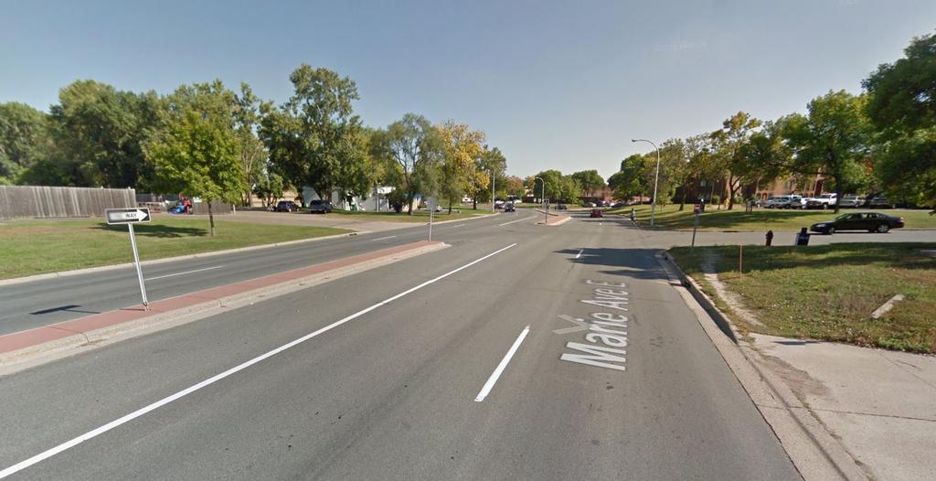
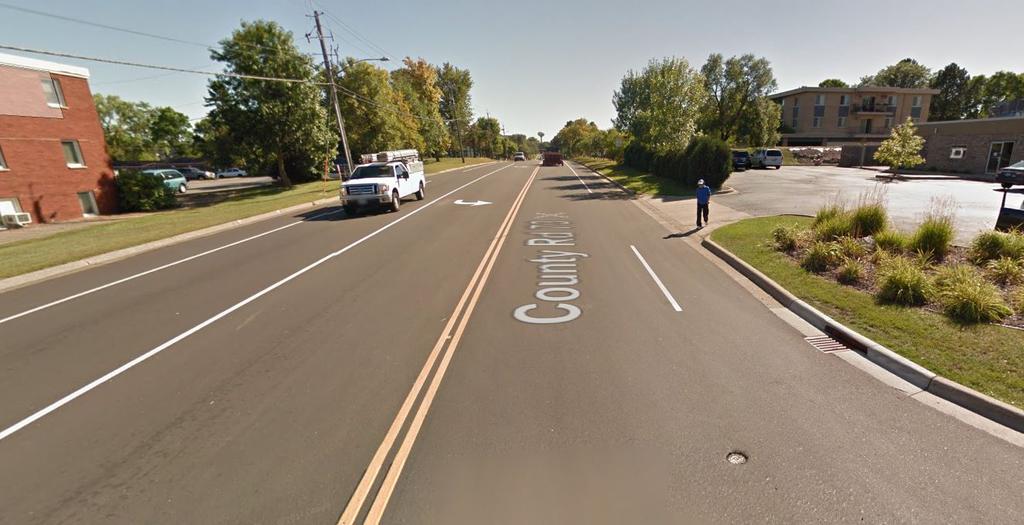
25 File Name Description File Size Attachment 1_Project Map_WSP Oakdale & Marie.pdf Attachment 2_Streetview_WSP Oakdale & Marie_Marie Ave Facing East at Kathleen St.pdf Attachment 3_Streetview_WSP Oakdale & Marie_Oakdale Ave Facing South at Marie Ave.pdf Attachment 4_Letter of Support_Dakota County DOT_WSP Oakdale & Marie.pdf Attachment 5_Resolution of Support_Dakota County_SSP Wentworth.pdf Project map showing the proposed improvements for the West St. Paul Oakdale and Marie Trail Extension project Google Streetview of existing conditions of section of project corridor along Marie Avenue Google Streetview of existing conditions along section of project corridor on Oakdale Avenue Letter of Support from the Dakota County Department of Transportation regarding the West St. Paul Oakdale and Marie Trail Extension project Resolution of support from the Dakota County Board supporting the City of West St. Paul's pursuit of funding for the Oakdale and Marie Trail Extension project 3.1 MB 1.8 MB 1.6 MB 566 KB 177 KB

26 1.588 miles Project to RBTN Orientation Multiuse Trails and Bicycle Facilities Project: West St. Paul Oakdale and Marie Trail Extension Map ID: NCompass Technologies Project RBTN Corridor Centerlines RBTN Tier 2 Alignment Principal Arterials RBTN Tier 1 RBTN Tier 2 RBTN Tier 1 Alignment Minor Arterials Miles Created: 7/12/2016 LandscapeRSA1 I For complete disclaimer of accuracy, please visit

27 1.588 miles Population Summary Multiuse Trails and Bicycle Facilities Project: West St. Paul Oakdale and Marie Trail Extension Map ID: Results Within ONE Mile of project: Total Population: Total Employment: Metropolitan Council 20 Project 2010 TAZ Miles Created: 7/12/2016 LandscapeRSA4 I For complete disclaimer of accuracy, please visit
 n n n n n n NCompass Technologies Project Area of Concentrated")
28 1.588 miles Socio-Economic Conditions Multiuse Trails and Bicycle Facilities Project: West St. Paul Oakdale and Marie Trail Extension Map ID: n Results Project located IN Area of Concentrated Poverty: (0 to 24 Points) n n n n n n NCompass Technologies Project Area of Concentrated Povertry > 50% residents of color n Above reg'l avg conc of race/poverty School Area of Concentrated Poverty Miles Created: 7/12/2016 LandscapeRSA2 I For complete disclaimer of accuracy, please visit

29 RIVER TO RIVER GREENWAY Wentworth Ave & P S Roberts St Walmart WEST ST. PAUL SPORTS COMPLEX Rainbow Oakdale Avenue Lothenbach Ave More than 2,500 jobs are located in this commercial and employment area Target ROBERT STREET CORRIDOR Oakdale Ave Marie Ave More than 2,000 residents live in the vicinity of Oakdale and Marie Avenues SOUTHVIEW PARK SOUTHVIEW COUNTRY CLUB Mendota Road Proposed Multi-Use Trail Regional Trail Proposed Sidewalks Existing Sidewalks Local Trails Bus Stops Higher Density Housing Employment Areas Commercial P Park & Ride & Proposed Bike Parking P West St. Paul Oakdale and Marie Trail Extension Project Summary
30
31
32 July 13, 2016 Physical Development Division Steven C. Mielke, Director Dakota County Western Service Center Galaxie Avenue Apple Valley, MN Fax Environmental Resources Land Conservation Groundwater Protection Surface Water Waste Regulation Environmental Initiatives Office of Planning Operations Management Facilities Management Fleet Management Parks Transportation Highways Surveyor's Office Transit Office Elaine Koutsoukos, Transportation Coordinator Transportation Advisory Board Metropolitan Council 390 Robert Street North St. Paul, MN RE: Federal STBGP Letter of Funding and Maintenance for CSAH 73 Dear Ms. Koutsoukos: The County Board of Commissioners has committed to support the proposed project for a multi-use trail along nearly one mile of CSAH 73 (Oakdale Avenue) between Mendota Road to CSAH 8 (Wentworth Avenue) and 0.55 miles on Marie Avenue between CSAH 73 (Oakdale Avenue) and TH 952 (Robert Street). This project would complete a high demand gap in the current trail facilities along Oakdale and Marie Avenues. The project will provide a direct connection to the River to River Greenway, an 8 mile regional trail connecting West St. Paul to South St Paul, Lilydale, and Mendota Heights. Dakota County is aware of and understands the proposed project being submitted. Dakota County has jurisdiction over CSAH 73 and commits to working with the City of West St. Paul to operate and maintain the proposed facilities along CSAH 73 for its useful design life. Dakota County appreciates efforts to secure funding for trail improvements along CSAH 73, and is supportive of the City of West St. Paul moving forward with this project. We will be happy to answer any questions you may have regarding this project. Sincerely, & J. Kr sbach, P.E. Transportation Director/County Engineer 0 Printed on recycled paper with 30% post-consumer waste. AN EQUAL OPPORTUNITY EMPLOYER
33 BOARD OF COUNTY COMMISSIONERS DAKOTA COUNTY, MINNESOTA June 21, 2016 Resolution No Motion by Commissioner Workman Second by Commissioner Holberg Approval Of Grant Application Submittals For Transportation Advisory Board 2016 Federal Funding Solicitation Process WHEREAS, the Transportation Advisory Board (TAB) is requesting project submittals for federal funding under the Fixing America s Surface Transportation (FAST) Act; and WHEREAS, these federal programs fund up to 80 percent of project construction costs; and WHEREAS, federal funding of projects reduces the burden local taxpayers for regional improvements; and WHEREAS, non-federal funds must be at least 20 percent of the project costs; and WHEREAS, project submittals are due on July 15, 2016; and WHEREAS, all projects proposed are consistent with the adopted Dakota County Comprehensive Plan; and WHEREAS, subject to federal funding award, the Dakota County Board of Commissioners would be asked to consider authorization to execute a grant agreement at a future meeting. NOW, THEREFORE, BE IT RESOLVED, That the Dakota County Board of Commissioners hereby approves the following County led projects for submittal to the TAB for federal funding: th Street Extension from ½ mile west of County State Aid Highway (CSAH) 31 to CSAH 31 and the existing 179th Street intersection with Flagstaff Avenue in Lakeville 2. CSAH 9 (Dodd Boulevard) from Heritage Way to CSAH 50 in Lakeville 3. CSAH 26 (Lone Oak Road/70th Street) from Trunk Highway (TH) 55 to TH 3 (Robert Street) in Eagan and Inver Grove Heights 4. CSAH 32 (Cliff Road) at its intersection with CSAH 31 (Pilot Knob Road) in Eagan 5. CSAH 23 (Foliage Avenue) from CSAH 86 (280th Street) to County Road 96 (320th Street) in Greenvale Township 6. CSAH 50 (202nd Street) from Holyoke Avenue to CSAH 23 (Cedar Avenue) in Lakeville 7. CSAH 86 (280th Street) from CSAH 23 (Galaxie Avenue) to TH 3 in Eureka, Greenvale, Castle Rock, and Waterford Townships 8. Minnesota River Greenway Eagan Gap Segment in Eagan 9. River to River Greenway TH 149 Underpass in Mendota Heights 10. River to River Greenway Robert Street Crossing Connections in West St Paul 11. North Creek Greenway CSAH 42 Underpass east of Flagstaff in Apple Valley; and Slavik Gaylord Egan Schouweiler Workman Holberg Gerlach STATE OF MINNESOTA County of Dakota VOTE I, Jennifer Reynolds, Clerk to the Board of the County of Dakota, State of Minnesota, do hereby certify that I have compared the foregoing copy of a resolution with the original minutes of the proceedings of the Board of County Commissioners, Dakota County, Minnesota, at their session held on the 21st day of June, 2016, now on file in the County Administration Department, and have found the same to be a true and correct copy thereof. Witness my hand and official seal of Dakota County this 23rd day of June, Clerk to the Board
34 12. CSAH 14 - Southview Boulevard from 20th Avenue to 3rd Avenue and 3rd Avenue from Southview Boulevard to Marie Avenue in South St. Paul; and BE IT FURTHER RESOLVED, That the Dakota County Board of Commissioners hereby supports the following submittals by others: th Street from CSAH 71 (Rich Valley Boulevard) to TH 52 Lead Agency: Inver Grove Heights 14. Orange Line Extension Lead Agency: Metro Transit 15. CSAH 73 (Oakdale Avenue) from CSAH 14 (Mendota Road) to CSAH 8 (Wentworth Avenue) Lead Agency: West St. Paul 16. TH 149 (Dodd Road) from Mendota Heights Road to Decorah Lane and from Maple Street to Smith Avenue Lead Agency: Mendota Heights 17. North Creek Greenway Farmington Gap Lead Agency: Farmington 18. CSAH 8 (Wentworth Avenue) from CSAH 63 (Delaware Avenue) to Humboldt Avenue Lead Agency: West St. Paul 19. CSAH 8 (Wentworth Avenue) from TH 52 to 15th Avenue Lead Agency: South St Paul; and BE IT FURTHER RESOLVED, That, subject to federal funding award of the city led projects, the Dakota County Board of Commissioners will provide the local match for regional greenway projects, and for non-greenway projects will provide Dakota County s share of the matching funds consistent with Dakota County transportation cost share policies. Slavik Gaylord Egan Schouweiler Workman Holberg Gerlach STATE OF MINNESOTA County of Dakota VOTE I, Jennifer Reynolds, Clerk to the Board of the County of Dakota, State of Minnesota, do hereby certify that I have compared the foregoing copy of a resolution with the original minutes of the proceedings of the Board of County Commissioners, Dakota County, Minnesota, at their session held on the 21st day of June, 2016, now on file in the County Administration Department, and have found the same to be a true and correct copy thereof. Witness my hand and official seal of Dakota County this 23rd day of June, Clerk to the Board
Primary Contact. Organization Information. Application Pedestrian Facilities (Sidewalks, Streetscaping, and ADA)
") Application 04787-2016 Pedestrian Facilities (Sidewalks, Streetscaping, and ADA) 05090 - St. Paul Sidewalk Gap Infill Project Regional Solicitation - Bicycle and Pedestrian Facilities Status: Submitted
Application 04787-2016 Pedestrian Facilities (Sidewalks, Streetscaping, and ADA) 05090 - St. Paul Sidewalk Gap Infill Project Regional Solicitation - Bicycle and Pedestrian Facilities Status: Submitted
Primary Contact. Organization Information. Application Multiuse Trails and Bicycle Facilities Lake Waconia Regional Trail
 Application 04786-2016 Multiuse Trails and Bicycle Facilities 05088 - Lake Waconia Regional Trail Regional Solicitation - Bicycle and Pedestrian Facilities Status: Submitted Date: Submitted 07/15/2016
Primary Contact. Organization Information. Application Multiuse Trails and Bicycle Facilities
 Application 04786-2016 Multiuse Trails and Bicycle Facilities 05294 - W 36th St Pedestrian and Bicycle Connection Regional Solicitation - Bicycle and Pedestrian Facilities Status: Submitted Date: Submitted
Primary Contact. Organization Information. Application Multiuse Trails and Bicycle Facilities CSAH 5/Stonebridge Trail Connection
 Application 04786-2016 Multiuse Trails and Bicycle Facilities 05269 - CSAH 5/Stonebridge Trail Connection Regional Solicitation - Bicycle and Pedestrian Facilities Status: Submitted Date: Submitted 07/15/2016
Primary Contact. Organization Information. Application Multiuse Trails and Bicycle Facilities Fish Hatchery Trail Reconstruction
 Application 04786-2016 Multiuse Trails and Bicycle Facilities 05260 - Fish Hatchery Trail Reconstruction Regional Solicitation - Bicycle and Pedestrian Facilities Status: Submitted Date: Submitted 07/15/2016
Primary Contact. Organization Information. Application Safe Routes to School Infrastructure
 Application 04788-2016 Safe Routes to School Infrastructure 05195 - Norwood Young America US212 Safety Improvement Project Regional Solicitation - Bicycle and Pedestrian Facilities Status: Submitted Date:
Bicycle and Pedestrian Chapter TPP Update Overview. TAB September 20, 2017
 Bicycle and Pedestrian Chapter TPP Update Overview TAB September 20, 2017 Bicycling & Walking in the Twin Cities Where are we now? The Bike-Pedestrian system Current trends New developments Where are we
ACTION TRANSMITTAL No
 Transportation Advisory Board of the Metropolitan Council of the Twin Cities ACTION TRANSMITTAL No. 2016-15 DATE: January 14, 2016 TO: TAC Planning Committee PREPARED BY: Steven Elmer (651) 602-1756 SUBJECT:
Primary Contact. Organization Information. Application Multiuse Trails and Bicycle Facilities
 Application 135-218 Multiuse Trails and Bicycle Facilities 1142 - Robert Piram Regional Trail Grade Separation at Barge Channel Rd Regional Solicitation - Bicycle and Pedestrian Facilities Status: Submitted
5. RUNNINGWAY GUIDELINES
 5. RUNNINGWAY GUIDELINES These guidelines should be considered collectively when making runningway decisions. A runningway is the linear component of the transit system that forms the right-of-way reserved
ACTION TRANSMITTAL No
 Transportation Advisory Board of the Metropolitan Council of the Twin Cities ACTION TRANSMITTAL No. 2016-15 DATE: January 14, 2016 TO: FROM: TAC TAC Planning PREPARED BY: Steven Elmer (651) 602-1756 SUBJECT:
Primary Contact. Organization Information. Application Safe Routes to School Infrastructure Expo Area Schools SRTS-2016 Appln
 Application 04788-2016 Safe Routes to School Infrastructure 05429 - Expo Area Schools SRTS-2016 Appln Regional Solicitation - Bicycle and Pedestrian Facilities Status: Submitted Date: Submitted 07/15/2016
Regional Bicycle Barriers Study
 Regional Bicycle Barriers Study Executive Summary Background and Purpose The 2040 Transportation Policy Plan (TPP) sets policies for planning and investment direction in the transportation system in the
CITY OF BLOOMINGTON COMPLETE STREETS POLICY
 CITY OF BLOOMINGTON COMPLETE STREETS POLICY POLICY OBJECTIVE: The City of Bloomington will enhance safety, mobility, accessibility and convenience for transportation network users of all ages and abilities,
Solana Beach Comprehensive Active Transportation Strategy (CATS)
") Solana Beach Comprehensive Active Transportation Strategy (CATS) 3.0 Goals & Policies The Solana Beach CATS goals and objectives outlined below were largely drawn from the Solana Beach Circulation Element
Solana Beach Comprehensive Active Transportation Strategy (CATS) 3.0 Goals & Policies The Solana Beach CATS goals and objectives outlined below were largely drawn from the Solana Beach Circulation Element
REGIONAL BICYCLE AND PEDESTRIAN DESIGN GUIDELINES
 REGIONAL BICYCLE AND PEDESTRIAN DESIGN GUIDELINES November 16, 2011 Deb Humphreys North Central Texas Council of Governments Bicycle and Pedestrian Advisory Committee Snapshot of the Guide 1. Introduction
Chapter 9: Pedestrians and Bicyclists
 Chapter 9: Pedestrians and Bicyclists Walking and bicycling are essential modes of transportation. These modes allow people to travel without contributing to congestion and air pollution, to access other
Chapter 7: Bicycle And Pedestrian Investment Direction
 7.1 Chapter 7: Bicycle And Pedestrian Investment Direction 2040 7.2 Chapter 7: Bicycle and Pedestrian Investment CONTENTS Overview 7.3 Regional Bicycle Transportation Network 7.6 Regional Bicycle System
Perryville TOD and Greenway Plan
 Perryville TOD and Greenway Plan Greenway Glossary Pathway: A bicycle and pedestrian path separated from motorized vehicular traffic by an open space, barrier or curb. Multi-use paths may be within the
AMATS Complete Streets Policy
 AMATS Complete Streets Policy Table of Contents: Section 1. Definition of Complete Streets Section 2. Principles of Complete Streets Section 3. Complete Streets Policy Section 4. Consistency Section 5.
ACTION TRANSMITTAL No
 Transportation Advisory Board of the Metropolitan Council of the Twin Cities DATE: March 12, 2015 TO: ACTION TRANSMITTAL No. 2015-20 TAC Funding and Programming Committee PREPARED BY: Joe Barbeau, Senior
CITY OF COCOA BEACH 2025 COMPREHENSIVE PLAN. Section VIII Mobility Element Goals, Objectives, and Policies
 CITY OF COCOA BEACH 2025 COMPREHENSIVE PLAN Section VIII Mobility Element Goals, Objectives, and Policies Adopted August 6, 2015 by Ordinance No. 1591 VIII MOBILITY ELEMENT Table of Contents Page Number
Living Streets Policy
 Living Streets Policy Introduction Living streets balance the needs of motorists, bicyclists, pedestrians and transit riders in ways that promote safety and convenience, enhance community identity, create
APPENDIX A: Complete Streets Checklist DRAFT NOVEMBER 2016
 APPENDIX A: Complete Streets Checklist DRAFT NOVEMBER 2016 Complete Streets Checklist MetroPlan Orlando s Complete Streets Checklist is an internal planning tool for staff to further implementation of
PEDESTRIAN ACTION PLAN
 ATTACHMENT 2 CITY OF SANTA MONICA PEDESTRIAN ACTION PLAN CITY OF SANTA MONICA PEDESTRIAN ACTION PLAN This page intentionally left blank EXECUTIVE SUMMARY CHAPTER 1 EXECUTIVE SUMMARY Setting the Stage
City of Novi Non-Motorized Master Plan 2011 Executive Summary
 City of Novi Non-Motorized Master Plan 2011 Executive Summary Prepared by: February 28, 2011 Why Plan? Encouraging healthy, active lifestyles through pathway and sidewalk connectivity has been a focus
Bus Rapid Transit Plans
 Twin Cities Region Bus Rapid Transit Plans ULI Minnesota Workshop Connecting Bus Rapid Transit to the Community December 15, 2009 John Levin Director of Service Development Metro Transit Metropolitan Area
General Plan Circulation Element Update Scoping Meeting April 16, 2014 Santa Ana Senior Center, 424 W. 3rd Street, Santa Ana, CA 92701
 General Plan Circulation Element Update Scoping Meeting April 16, 2014 Santa Ana Senior Center, 424 W. 3rd Street, Santa Ana, CA 92701 Meeting Agenda 1. Purpose of Scoping Meeting 2. Project Overview 3.
ACTIVE TRANSPORTATION
 ACTIVE TRANSPORTATION Mobility 2040 Supported Goals Improve the availability of transportation options for people and goods. Support travel efficiency measures and system enhancements targeted at congestion
Proposed. City of Grand Junction Complete Streets Policy. Exhibit 10
 Proposed City of Grand Junction Complete Streets Policy Exhibit 10 1 City of Grand Junction Complete Streets Policy Vision: The Complete Streets Vision is to develop a safe, efficient, and reliable travel
Chapter 2. Bellingham Bicycle Master Plan Chapter 2: Policies and Actions
 Chapter 2 Bellingham Bicycle Master Plan Chapter 2: Policies and Actions Chapter 2: Policies and Actions The Bicycle Master Plan provides a road map for making bicycling in Bellingham a viable transportation
ACTION TRANSMITTAL No
 Transportation Advisory Board of the Metropolitan Council of the Twin Cities ACTION TRANSMITTAL No. 2016-15 DATE: February 5, 2016 TO: FROM: Transportation Advisory Board Technical Advisory Committee PREPARED
RESOLUTION NO ?? A RESOLUTION OF THE CITY OF NEPTUNE BEACH ADOPTING A COMPLETE STREETS POLICY
 RESOLUTION NO. 2018-?? A RESOLUTION OF THE CITY OF NEPTUNE BEACH ADOPTING A COMPLETE STREETS POLICY WHEREAS, safe, convenient, and accessible transportation for all users is a priority of the City of Neptune
Chapter 5 Future Transportation
 Chapter 5 Future Transportation The Future Land Use Plan identifies the desired land use designations. The land uses desired for Crozet depend, in large part, on the success of the transportation system,
NM-POLICY 1: Improve service levels, participation, and options for non-motorized transportation modes throughout the County.
 Transportation PRINCE WILLIAM COUNTY 2008 COMPREHENSIVE PLAN NON-MOTORIZED PLAN CONTENTS Goals, Policies, and Action Strategies Table 4 (Bike Facility Classifications and Descriptions) Table 5 (Bike Facility
New Measure A Expenditure Categories DEFINITIONS OF ELIGIBLE EXPENDITURES Adopted March 8, 2007
 New Measure A Expenditure Categories DEFINITIONS OF ELIGIBLE EXPENDITURES Adopted March 8, 2007 City Street and County Road Maintenance Program The preservation and keeping of public street and road rights-of-way
APPROVE A RESOLUTION ADOPTING A COMPLETE STREETS POLICY
 STAFF REPORT MEETING DATE: September 13, 2016 TO: FROM: City Council Bob Brown, Community Development Director Russ Thompson, Public Works Director Patrick Filipelli, Management Analyst 922 Machin Avenue
West Dimond Blvd Upgrade Jodhpur Street to Sand Lake Road
 West Dimond Blvd Jodhpur St to Sand Lake CSS Transportation Project Summary Municipality of Anchorage Project # 05 005 Project Manager: John Smith, P.E. (MOA PM&E) Project Administrator: Julie Makela,
Project Update May 2018
 Project Update May 2018 Dakota County, in cooperation with the City of Lakeville, is planning to reconstruct 202 nd Street West (County Road 50) from Holyoke Avenue to Cedar Avenue (County Road 23). 202
Exhibit 1 PLANNING COMMISSION AGENDA ITEM
 Exhibit 1 PLANNING COMMISSION AGENDA ITEM Project Name: Grand Junction Circulation Plan Grand Junction Complete Streets Policy Applicant: City of Grand Junction Representative: David Thornton Address:
CITY OF KASSON TRANSPORTATION ALTERNATIVES KASSON SAFE ROUTES TO SCHOOL
 ve ha 8t G B A Mantorville Ave N 240th Ave 16th St NE 11th Ave NE K-M HIGH SCHOOL SUNRISE TRAIL TO MANTORVILLE MNTH 57 SUNSET TRAIL TO MANTORVILLE NE PARK 16TH ST NE TRAIL K-M ELEMENTARY SCHOOL K-M MIDDLE
TRANSPORTATION TRAINING TOPICS. April 6, 2010
 TRANSPORTATION TRAINING TOPICS April 6, 2010 Roles of Transportation Providers Context and Policy Makers Division of Transportation and Traffic Other City Operations Other Transportation Operators CMA
Houma-Thibodaux Metropolitan Planning Organization STP<200K Funding Application APPLICATION
 APPLICATION HOUMA-THIBODAUX METROPOLITAN PLANNING ORGANIZATION (HTMPO) FOR SURFACE TRANSPORTATION PROGRAM (STP
SANTA CLARA COUNTYWIDE BICYCLE PLAN August 2008
 SANTA CLARA COUNTYWIDE BICYCLE PLAN August 2008 To assist VTA and Member Agencies in the planning, development and programming of bicycle improvements in Santa Clara County. Vision Statement To establish,
Overview. Illinois Bike Summit IDOT Complete Streets Policy Presentation. What is a Complete Street? And why build them? And why build them?
 Overview Illinois Bike Summit IDOT Complete Streets Policy Presentation Aren Kriks, P.E. District One Bicycle Coordinator and Bureau of Programming Project Engineer History of Complete Streets IDOT Policy
City of Wayzata Comprehensive Plan 2030 Transportation Chapter: Appendix A
 A1. Functional Classification Table A-1 illustrates the Metropolitan Council s detailed criteria established for the functional classification of roadways within the Twin Cities Metropolitan Area. Table
Agenda. Overview PRINCE GEORGE S PLAZA METRO AREA PEDESTRIAN PLAN
 PRINCE GEORGE S PLAZA METRO AREA PEDESTRIAN PLAN May 28, 2008 Agenda Welcome and introductions Project overview and issue identification Planning context and strengths Design challenges and initial recommendations
Chapter 14 PARLIER RELATIONSHIP TO CITY PLANS AND POLICIES. Recommendations to Improve Pedestrian Safety in the City of Parlier (2014)
") Chapter 14 PARLIER This chapter describes the current status and future plans for biking and walking in the City of Parlier. RELATIONSHIP TO CITY PLANS AND POLICIES The Parlier General Plan is the primary
Chapter 14 PARLIER This chapter describes the current status and future plans for biking and walking in the City of Parlier. RELATIONSHIP TO CITY PLANS AND POLICIES The Parlier General Plan is the primary
Phone: Fax: Project Reference No. (to be filled out by MassHighway):
:") Massachusetts Highway Department District 3 Project Need Form (PNF) This form is intended to provide preliminary information about the proposed project. It is not expected that all information that is
Massachusetts Highway Department District 3 Project Need Form (PNF) This form is intended to provide preliminary information about the proposed project. It is not expected that all information that is
Land Use Bicycle Spaces Required Type Residential
 SAMPLE ORDINANCES AND RESOLUTIONS APPENDIX B SAMPLE BICYCLE PARKING ORDINANCE Land Use Bicycle Spaces Required Type Residential Single Family/Two Family N/A N/A Apartment/Townhome 1 per unit plus 6 space
Clackamas County Comprehensive Plan
 ROADWAYS The County s road system permits the movement of goods and people between communities and regions, using any of a variety of modes of travel. Roads provide access to virtually all property. They
Beyond First First Last Last Mile Strategies. APA National Conference April 3, 2016 Chelsea Richer, AICP Fehr & Peers
 Beyond First First Last Last Mile Strategies APA National Conference April 3, 2016 Chelsea Richer, AICP Fehr & Peers 1 Beyond First Last Mile Strategies APA National Conference Jeremy Klop, AICP, Fehr
ACTION TRANSMITTAL No
 Transportation Advisory Board of the Metropolitan Council of the Twin Cities ACTION TRANSMITTAL No. 2014-63 DATE: September 5, 2014 TO: Funding & Programming Committee PREPARED BY: Joe Barbeau, Senior
NJDOT Complete Streets Checklist
 Background The New Jersey Department of Transportation s Complete Streets Policy promotes a comprehensive, integrated, connected multi-modal network by providing connections to bicycling and walking trip
Hennepin County Bicycle and Pedestrian Planning
 Hennepin County Bicycle and Pedestrian Planning 1 Value of bicycle and sidewalk systems Safety Livability Mobility Health Personal Finances Economic Sustainability Clean Air Recreation Parking and congestion
CONNECTING PEOPLE TO PLACES
 CONNECTING PEOPLE TO PLACES 82 EAST BENCH MASTER PLAN 07 Introduction The East Bench transportation system is a collection of slow moving, treelined residential streets and major arteries that are the
PRINCE GEORGE S PLAZA METRO AREA PEDESTRIAN PLAN
 PRINCE GEORGE S PLAZA METRO AREA PEDESTRIAN PLAN May 28, 2008 Agenda Welcome and introductions Project overview and issue identification Planning context and strengths Design challenges and initial recommendations
3.9 Recreational Trails and Natural Areas
 3.9 Recreational Trails and Natural Areas 3.9.1 Introduction Parks and other recreational facilities such as trails, bicycle routes, and open space are important community resources. This section discusses
Philip Schaffner Minnesota Department of Transportation October 22, 2013
 Philip Schaffner Minnesota Department of Transportation October 22, 2013 Going beyond performance measures & targets MnDOT has been using performance-based planning and programming for 10 years, but CIMS
Chapter 7. Transportation. Transportation Road Network Plan Transit Cyclists Pedestrians Multi-Use and Equestrian Trails
 Chapter 7 Transportation Transportation Road Network Plan Transit Cyclists Pedestrians Multi-Use and Equestrian Trails 7.1 TRANSPORTATION BACKGROUND The District of Maple Ridge faces a number of unique
o n - m o t o r i z e d transportation is an overlooked element that can greatly enhance the overall quality of life for the community s residents.
 N o n - m o t o r i z e d transportation is an overlooked element that can greatly enhance the overall quality of life for the community s residents. 84 Transportation CHAPTER 11 INTRODUCTION Transportation
4APNOIPF Vh, YII PTC CITY COUNCIL AGENDA REPORT. Honorable Mayor and City Council Members. 8K TH 63 River Crossing Bridge Replacement Project
 City of RE 4APNOIPF Vh, X` W\ YII PTC ING, CITY COUNCIL AGENDA REPORT Council Meeting Date: September 26, 2016 To: From: Agenda Item: Honorable Mayor and City Council Members Ron Rosenthal, Engineering
ACTIVE TRANSPORTATION/NONMOTORIZED TRANSPORTATION
 ACTIVE TRANSPORTATION/NONMOTORIZED TRANSPORTATION BACKGROUND Active transportation, also known as nonmotorized transportation, is increasingly recognized as an important consideration when planning and
RESOLUTION NO A RESOLUTION OF THE CITY COUNCIL OF THE CITY OF MENLO PARK ADOPTING A COMPLETE STREETS POLICY
 RESOLUTION NO. 6123 A RESOLUTION OF THE CITY COUNCIL OF THE CITY OF MENLO PARK ADOPTING A COMPLETE STREETS POLICY WHEREAS, the term Complete Streets describes a comprehensive, integrated transportation
CITY OF SEATTLE RESOLUTION. WHEREAS, the Washington State Department of Transportation (WSDOT) led the Seattle
 led the Seattle") SDOT SR0 Design Refinements RES August, 0 Version #D 0 CITY OF SEATTLE RESOLUTION..title A RESOLUTION relating to the State Route 0, Interstate to Medina Bridge Replacement and High Occupancy Vehicle Project;
SDOT SR0 Design Refinements RES August, 0 Version #D 0 CITY OF SEATTLE RESOLUTION..title A RESOLUTION relating to the State Route 0, Interstate to Medina Bridge Replacement and High Occupancy Vehicle Project;
A Matter of Fairness: ROCOG s Environmental Justice Protocol. What is Mobility Limitation?
 No Person Left Behind What is Mobility Limitation? What is the Access Limitation? Environmental Justice population should be provided adequate mobility & access to meet their needs; Identify acceptable
Houma-Thibodaux Metropolitan Planning Organization STP<200K Funding Application APPLICATION
 APPLICATION HOUMA-THIBODAUX METROPOLITAN PLANNING ORGANIZATION (HTMPO) FOR SURFACE TRANSPORTATION PROGRAM (STP
CHAPTER 7.0 IMPLEMENTATION
 CHAPTER 7.0 IMPLEMENTATION Achieving the vision of the Better Streets Plan will rely on the ability to effectively fund, build and maintain improvements, and to sustain improvements over time. CHAPTER
2018 Pedestrian and Bicycle and Safe Routes to School Application for Funding Page 1 of 31
 2018 Pedestrian and Bicycle and Safe Routes to School Application for Funding Page 1 of 31 2018 Pedestrian and Bicycle and Safe Routes to School Application for Funding Part 1: General Information Funding
TOWN OF PORTLAND, CONNECTICUT COMPLETE STREETS POLICY
 TOWN OF PORTLAND, CONNECTICUT COMPLETE STREETS POLICY I. VISION, GOALS & PRINCIPLES VISION To improve the streets of Portland making them safer and more accessible for all users including pedestrians,
INDOT Complete Streets Guideline & Policy
 INDOT Complete Streets Guideline & Policy INTRODUCTION The Complete Streets guidelines build upon multiple efforts and promote a multimodal transportation system that is integrated and sustains land use
6.0 PEDESTRIAN AND BICYCLE FACILITIES 6.1 INTRODUCTION 6.2 BICYCLE DEMAND AND SUITABILITY Bicycle Demand
 6.0 PEDESTRIAN AND BICYCLE FACILITIES 6.1 INTRODUCTION Bicycle and pedestrian travel along and in the vicinity of the corridor is part of the vision of Somerset and Hunterdon counties and the integrated
CITY OF VAUGHAN EXTRACT FROM COUNCIL MEETING MINUTES OF OCTOBER 30, 2012
 CITY OF VAUGHAN EXTRACT FROM COUNCIL MEETING MINUTES OF OCTOBER 30, 2012 Item 31, Report No. 39, of the Committee of the Whole, which was adopted without amendment by the Council of the City of Vaughan
Bicycling & Walking in the Twin Cities TPP Bike/Ped Chapter Overview. Land Use Advisory Committee September 21, 2017
 Bicycling & Walking in the Twin Cities TPP Bike/Ped Chapter Overview Land Use Advisory Committee September 21, 2017 Presentation Outline Current TPP Purpose of bike/ped chapter New developments Bike/Ped
TRANSPORTATION & MOBILITY
 TRANSPORTATION & MOBILITY ROADWAY SYSTEM There are approximately 40 miles of roadways in Manitou Springs. For planning purposes, roadways are typically assigned a functional classification which defines
Chapter 13 ORANGE COVE
 Chapter 13 ORANGE COVE This chapter describes the current status and future plans for biking and walking in the City of Orange Cove. RELATIONSHIP TO CITY PLANS AND POLICIES The Orange Cove General Plan
MAG Town of Cave Creek Bike Study Task 6 Executive Summary and Regional Significance Report
 Page 1 MAG Town of Cave Creek Bike Study Task 6 Executive Summary and Regional Significance Report August 1, 2012 MAG Project #481 Page 2 Task 6 Executive Summary and Regional Significance Report Introduction
Appendix 3 Roadway and Bike/Ped Design Standards
 Appendix 3 Roadway and Bike/Ped Design Standards OTO Transportation Plan 2040 4/20/2017 Page A3-1 Adopted Standards The adopted OTO Design Standards and Major Thoroughfare Plan are contained herein.
CITY OF SIGNAL HILL Cherry Avenue Signal Hill, CA
 CITY OF SIGNAL HILL 2175 Cherry Avenue Signal Hill, CA 90755-3799 AGENDA ITEM TO: HONORABLE MAYOR AND MEMBERS OF THE CITY COUNCIL FROM: STEVE MYRTER, P. E. DIRECTOR OF PUBLIC WORKS SUBJECT: SPRING STREET
Information Item. Transit and TDM Projects. Range of 22%-32% of Funds. Range of $31.58-$45.94 M
 Transportation Advisory Board of the Metropolitan Council of the Twin Cities DATE: April 9, 2015 Information Item TO: Transportation Advisory Board PREPARED BY: Steve Peterson, Planning Analyst 651-602-1819)
Transportation Corridor Studies: Summary of Recommendations
 Transportation Corridor Studies: Summary of Recommendations Route 4 Corridor Study: Route 10 Corridor Study: Route 44 Corridor Study: Route 175 Corridor Study: Route 5/15 Corridor Study: Rentschler Field
Michael Parmer, Management Aide, City Manager's Office
 P139 STAFF REPORT f CITY NL- NAGER' S OFFICE RANCHO Date: C;UCAMONGA To: From: Subject: Mayor and Members of the City Council John R. Gillison, City Manager Michael Parmer, Management Aide, City Manager's
Lee s Summit Road Improvement Study Public Open House June 7, 2007 Summary of Comment Card Responses
 Lee s Summit Road Improvement Study Public Open House June 7, 2007 Summary of Comment Card Responses Introduction At the Lee s Summit Road Improvement Study Public Open House held Thursday, June 7, 2007
Improvements Infrastructure Gap Assessment and Improvements Street Striping
 Infrastructure Project Proposal The federal-aid Safe Routes to School program funds infrastructure/engineering projects that fall into two categories: Design (available only to School Development Authority
Non-Motorized Transportation 7-1
 Non-Motorized Transportation 7-1 Transportation facilities no longer mean just accommodating a vehicle powered by a combustion engine. Pedestrian and non-motorized facilities are important modes of travel
Welcome to the Open House
 Leslie Street Between 19 th Avenue and Stouffville Road Addendum to Class Environmental Assessment Study Welcome to the Open House Please sign in at the front desk. March 28, 2017 Richmond Green Sports
1.0 EXECUTIVE SUMMARY
 1.0 EXECUTIVE SUMMARY The Active Transportation Plan is a guide to accomplish the Town s vision for developing a network of sidewalks, on-road bicycle facilities, and trails that allow for safe and convenient
4 Goals, Objectives & Actions
 Chapter4 4 This chapter presents goals, objectives, and recommended actions to support the vision of making Overland Park a safer and easier place to ride a bicycle. 35 4.1 Recommendations Structure The
Reams Road RCA Study. Board of County Commissioners Public Hearing
 Reams Road RCA Study Board of County Commissioners Public Hearing April 24, 2018 Presentation Overview Study Overview Existing Conditions Development of Alternatives Preferred Alternative Public Involvement
Twin Cities Regional Bicycle System Study
 Twin Cities Regional Bicycle System Study Developing a Regional Bicycle Network Steven Elmer, Metropolitan Council Tony Hull, Toole Design Group LLC CTS Research Conference May 21, 2014 Introduction Study
AGENDA ITEM NO. 5b HCAOG TAC meeting of May 8, 2014
 Humboldt County Association of Governments Eureka, CA, 95501 AGENDA ITEM NO. 5b HCAOG TAC meeting of May 8, 2014 DATE: May 1, 2014 TO: HCAOG Technical Advisory Committee (TAC) FROM:, SUBJECT: Letters of
Complete Streets Workshop Follow-up. April 27, 2011 Rockledge City Hall
 Complete Streets Workshop Follow-up April 27, 2011 Rockledge City Hall Agenda Complete Streets draft briefing presentation and sample policy language Share your Complete Streets projects and post workshop
Omaha s Complete Streets Policy
 Omaha s Complete Streets Policy (Adopted August 2015) VISION To create great places and enhance our quality of life, the City of Omaha will provide safe, accessible streets for all users. Complete Streets
Rochester Downtown Bicycle Study 2009
 Rochester Downtown Bicycle Study 2009 Relationship of ROCOG Long Range Transportation Plan to Rochester Comprehensive Plan Regional Long Range Transportation Plan (LRTP) is prepared under the auspices
St. Francis Drive through the City of Santa Fe Corridor Study
 VII. ENGINEERING AND ENVIRONMENTAL EVALUATION TRAIL CONNECTIVITY In the southern portion of the Corridor there is a lack of a sidewalk, trail or bicycle facility within the right-ofway. However, the City
Madison Urban Area and Dane County. Bicycle Transportation Plan Summary. September Introduction. Bicycle Plan Scope and Planning Process
 Bicycle Transportation Plan Summary Madison Urban Area and Dane County Introduction September 2000 Bicycling is an important mode of transportation in the Madison urban area and countywide that is available
Preliminary Engineering Study
 Preliminary Engineering Study Open House # 2 June 6, 2018 PREPARED FOR: PREPARED BY: Agenda Background and status of preliminary engineering study County Road 26 design summary County Road 63 design summary
MCTC 2018 RTP SCS and Madera County RIFP Multi-Modal Project Eval Criteria GV13.xlsx
 MCTC 8 RTP SCS and Madera County RIFP Multi-Modal Project Eval Criteria GV.xlsx Madera County Transportation Commission Regional Transportation Plan / Sustainable Communities Strategy Multi-Modal Project
Active Transportation Facility Glossary
 Active Transportation Facility Glossary This document defines different active transportation facilities and suggests appropriate corridor types. Click on a facility type to jump to its definition. Bike
Traffic Calming Policy
 Article I. Purpose and Goal. The purpose of this policy is to establish criteria and procedures the City will use to evaluate requests for, and if appropriate, implement traffic calming measures. Neighborhood