City of Decatur, GA. Speed Limits Study and Proposal
|
|
|
- Tracy Ralf Malone
- 6 years ago
- Views:
Transcription

1 City of Decatur, GA Speed Limits Study and Proposal
2 Table of Contents SUMMARY 2 HEALTH IMPACTS 5 EXAMPLES 6 ASSESSMENT 7 Current Speed Limits 7 Safe Routes To School 9 Speed Limit Enforcement 11 Accidents 13 Community Facilities 15 Infrastructure 17 Street Typology 19 PROPOSAL 21 APPENDIX A: CURRENT STREET CLASIFICATIONS 22 APPENDIX B: COMMUNITY TRASNPORTATION PLAN STREET TYPOLOGY 25

3 SUMMARY At the request of a number of residents, the City of Decatur, GA conducted a review of speed limits and several other traffic related issues within the jurisdiction. Based on this research and adopted policies a comprehensive, City-wide update for speed limits is being proposed to improve consistency and to improve conditions to support the community s vision of Decatur as a safe, walkable and bike-friendly place for all ages. This proposal is, in large part, inspired by the Georgia Department of Transportation s adoption of a Complete Streets Policy in This policy requires the Department to routinely incorporate bicycle, pedestrian, and transit (user and transit vehicle) accommodations into transportation infrastructure projects as a means for improving mobility, access, and safety for the traveling public. This mirrors the Complete Streets policy adopted by the City as part of the Community Transportation Plan (CTP) enacted in 2008, which was the first transportation plan in the United States to incorporate a Health Impact Assessment. As Decatur s sense of place has evolved in recent years, so has the understanding of how streets and the built environment impact human health. The plan states that, The CTP employs a Complete Streets philosophy that defines the street by more than juts its mobility and accessibility functions, but by its role as a critical community character shaper. The design of our environment affects how people connect with one another and how a community establishes a sense of place. Revising speed limits at a comprehensive community level provides the opportunity to create a consistent policy for areas of similar land use and character. This approach has not been used previously in the State of Georgia. Traditionally, speed limits are addressed on individual basis, with specific vehicular traffic data and research presented to the Georgia Department of Transportation for each street. Decatur is well suited to take a broader approach to the issue. In addition to being one of the most densely populated cities in the State of Georgia, the community has a longstanding tradition of smart-growth planning with emphasis on capital projects that enhance transportation options for its residents. Why else is Decatur a unique location for this project? A population density of over 4,500 residents per square mile. Award winning Safe Routes to School program. A thriving downtown business district with over 200 retail and restaurant locations. 3 MARTA rail stations within the jurisdiction. Diligent traffic enforcement, which was expanded in 2009 to included dedicated traffic patrol. A property tax base comprised of 85% residential property. Popular events that attract thousands of attendees each year. A 10-year sidewalk improvement campaign. Bronze level Bike Friendly Community status and Silver level Walk Friendly Community status. Significant interest among residents in issues related to traffic calming. Page 2

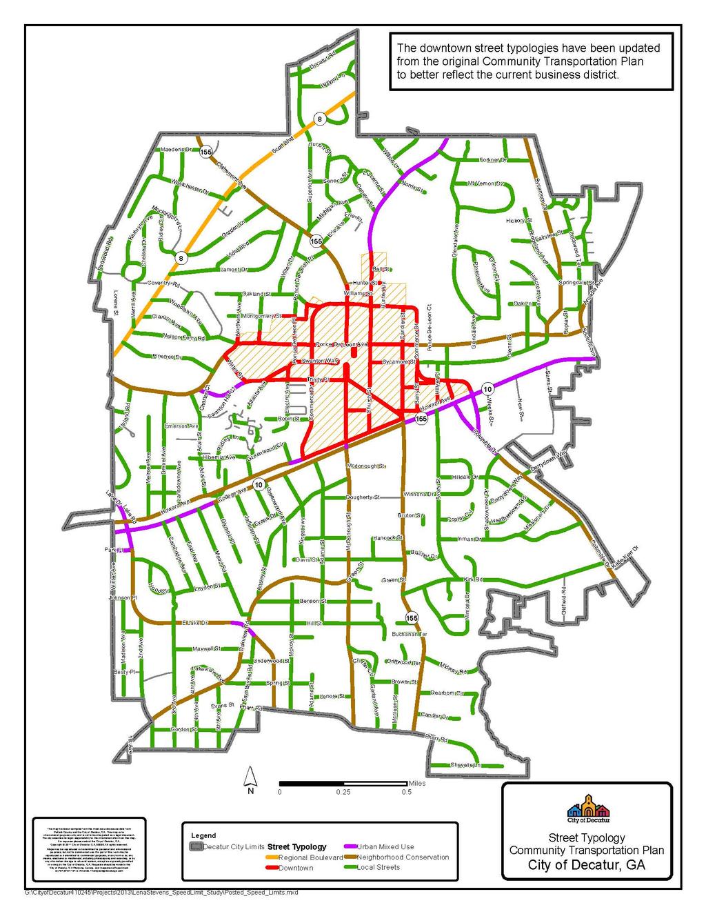
4 For this proposal, the City carefully assessed current street conditions and recent infrastructure improvements. Posted speed limits for all streets were inventoried. Additionally, information was gathered and analyzed on speeding violations, traffic accidents, sidewalk coverage, bicycle lanes, safe routes to school and community facilities. Based on this analysis, the City of Decatur is proposing that a comprehensive update of all speed limits be made to better align with the street typologies identified in the Decatur Community Transportation Plan and to implement recommendations for creating healthy environments. The typology classification serves as an overlay to the functional classification system currently used by Georgia Department of Transportation that is designed to more accurately represent the character of Decatur s community streets. The CTP identifies a typology for each street in the City. The typology takes into account the function of the street, as well as recognizing that the adopted land use, building form, mix of uses and density of development play an important part in the overall transportation needs of the community. Decatur streets do more than simply serve a function: they help build relationships between buildings and sites along the way; they offer a connection between places and people; and, they can serve to support a healthy lifestyle. They are a public resource for all modes of travel. The typology categories adopted in the CTP are listed below, along with the targeted speed limits. Table 1: Street Typology- Community Transportation Plan Arterials Regional Boulevard Downtown Core Urban Mixed Use Neighborhood Conservation Targeted Limit (mph) Non Arterials Medium and High Density Residential Low Density Residential Alley/Service Page 3
5 Page 4
6 HEALTH IMPACTS The built environment, particularly our transportation system, plays a large role in facilitating the opportunity to live a healthy lifestyle. The Georgia Department of Health reports that the leading cause of death in Georgia is cardiovascular disease. 1, 2 One of the primary prevention strategies is to create environments where people can routinely incorporate physical activity as part of their daily lives. Vulnerable populations such as those who are transit dependent, elderly and/or minorities experience poor health at a greater rate due to lack of access to safe transportation options and nutritious food. The implementation of a Complete Streets policy is a critical tool to help create access for all populations for safe, active modes of travel. Lower vehicle speeds are fundamental to creating actual and perceived safety for pedestrians or cyclists. The Health Impact Assessment for the Decatur Community Transportation Plan contained several recommendations on how the City could encourage good health for its residents and visitors through the transportation system. This included emphasizing mobility, increasing the use of alternative transportation, partnering with the schools to implement Safe Routes to Schools and making traffic safety a priority. Implementing a consistent speed limit is a key strategy to improve traffic safety in the City. Studies show that speed has a direct relationship to the severity of the injuries sustained in a crash. 3 While there have been numerous safety improvements to vehicles in the past decade to protect drivers during a crash, pedestrians still remain the most vulnerable and most likely to die in an accident when struck by a vehicle. As driving speed increases, so does the likelihood of a collision. Increased impact speed, in turn, results in a sharp increase in injury severity because of the power relationship between impact speed and the energy released in a crash. 3 As the City of Decatur continues to encourage its population to use alternative methods of transportation, lowering speed limits is part of the strategy to create a safe environment and minimize the chances of injury and death. This proposal shows how the City s current land use and programs are encouraging walking, cycling and transit use. It describes our efforts to manage speed through road design, enforcement and public education. Ultimately, this proposal is based on a policy of improving public health by enhancing safety and promoting physical activity. Obesity and other forms of chronic disease are preventable and the City of Decatur is committed to addressing this leading cause of death in Georgia. 1 Centers for Disease Control and Prevention. (2008). Georgia: Burden of Chronic Diseases. Retrieved from 2 Centers for Disease Control and Prevention. Georgia Fact Sheet. Retrieved from 3 Transportation Research Board; National Research Council. (1998). Managing Speed: Review of Current Practices for Setting and Enforcing Speed Limits. Page 5


7 EXAMPLES Aspen, Colorado Population: 6,680 (35,000 estimated in tourist season) Size: 3.87 square miles In March, 2013, the Aspen City Council voted to reduce speed limits through much of the City from 25 mph to 20 mph with only a handful of exceptions. The change was initiated by resident complaints that 25 mph was too fast for neighborhood streets, especially those used as shortcuts to avoid the main streets. Streets with an 85th percentile operating speed of 26 mph or above were targeted for future traffic calming projects, because with the new speed limit these streets would now experience speeds that exceeded the speed limit. To reduce signage costs, and sign pollution, the City put signs at main entryways that say Speed Limit is 20mph unless Otherwise Posted. Portland, Oregon Population: 603,106 Size: 133 square miles Portland s Neighborhood Greenway program was established to create a network of world-class residential streets that connect schools and parks while providing access to business and transit. The Greenways provide safe options for walking and bicycling that work in concert with the Safe Routes to School Program. Based on a review of traffic data, the Portland Bureau of Transportation identified several of these streets to be designated 20 MPH streets because they have fewer than 2,000 motor vehicles per day, have 85th percentile speeds lower than 30 MPH, and have pavement markings to indicate the presence of pedestrians and bicyclists. Columbia, Missouri Population: 113,000 Size: 63 square miles In 2009, the Columbia City Council approved a consistent methodology for speed limits on residential streets with traffic volumes of less than 2,000 cars per day. The community has a long tradition of traffic calming initiatives and promoting non-motorized transportation alternatives. The goal of the project was to create a consistent methodology of setting speed limits and placing signs on residential streets in order to minimize speed and traffic on low volume residential streets and facilitate the safest possible traffic movement on collector and arterial streets. Additionally, the Council directed that kid friendly neighborhood signs be erected in conjunction with the speed limit change. Page 6
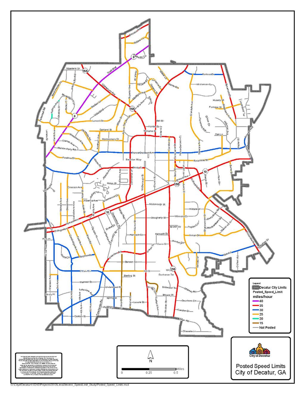
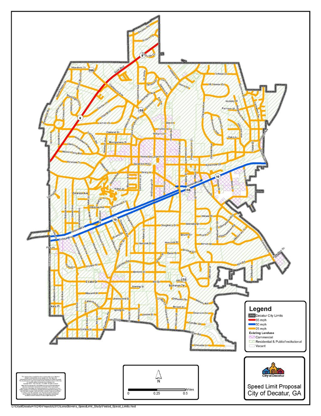
8 ASSESSMENT CURRENT SPEED LIMITS Incongruities exist in the current established speed limits in the City of Decatur. Areas of similar character and typology have varying speed limits that do not reflect current usage. This results in confusion among drivers and inequity between neighborhoods. HIGHLIGHTS (SEE MAP ON NEXT PAGE) Posted speed limits range from 15mph to 40mph. Neighborhoods with similar demographics and usage do not necessarily have consistent speed limits. Several streets have no posted limits which default to 30 mph. Speed limits on major streets vary as follows: o o o o o o o o Scott Boulevard- 40mph Church Street- 35mph Clairemont Avenue- 35mph College Avenue/Howard Avenue- 35mph Commerce Drive- 35mph South Candler Street- 35mph Ponce de Leon Avenue- 30mph East Lake Drive- 30mph Page 7
9 Page 8
10 SAFE ROUTES TO SCHOOL Decatur has had an active Safe Routes to School (SRTS) program since Beginning with the school year, the Decatur Active Living Division took on the management and development of Decatur s program. With strong support from the school system, parents, and students, Decatur has developed an award winning and innovative program. HIGHLIGHTS (SEE MAP ON NEXT PAGE) The Centers for Disease Control reports that in 2010, more than one third of children and adolescents were overweight or obese. Schools play a particularly critical role by establishing a safe and supportive environment with policies and practices that support healthy behaviors. Schools also provide opportunities for students to learn about and practice healthy eating and physical activity behaviors. 4 The Decatur Safe Routes to Schools programs utilizes the Four E s Engineering, Enforcement, Education, Encouragement to make it safe and attractive for students to walk and bicycle to our neighborhood schools. The Safe Routes program began as a Georgia Department of Transportation funded pilot project in January 2005 at 2 school sites and has since expanded to 6 public school sites and 1 private school site. The routes identified for the SRTS program span the entire community. Several routes involve crossing busy streets and state highways. 4 Centers for Disease Control and Prevention. Childhood Obesity Facts. Retrieved from Page 9
11 Page 10
12 SPEED LIMIT ENFORCEMENT The Decatur Police Department has an active traffic enforcement program which was expanded in 2009 to include dedicated traffic patrol. Enforcement of speed limits, especially in school zones, is a critical component of this effort. HIGHLIGHTS (SEE MAP ON NEXT PAGE) The highest volume of speeding violations in 2011 was on Scott Blvd. (SR 8), Clairemont Avenue (SR 155), College Avenue, and West Ponce de Leon Avenue. Many of the streets where speeding is an issue is in close proximity to schools and other community facilities. Page 11
13 Page 12
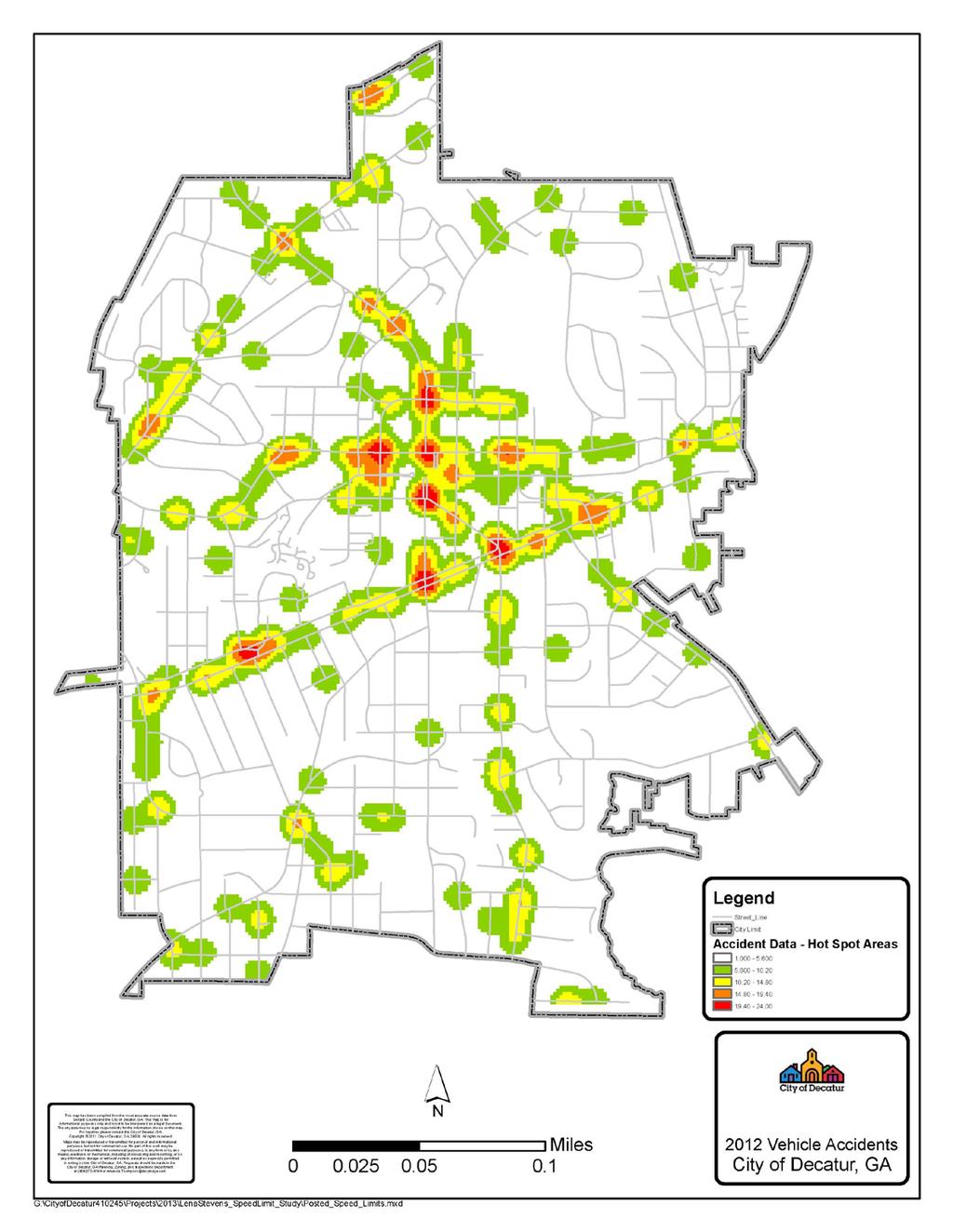
14 ACCIDENTS Increasing the safety of motorists and pedestrians is a significant motivation for this project. While the correlation between speed limits and traffic accidents is not absolute, a more comprehensive speed limit strategy, combined with traffic enforcement and calming efforts is expected to reduce the number of accidents. HIGHLIGHTS (SEE MAP ON NEXT PAGE) Traffic accidents were most common on streets with speed limits of 35 mph or higher and around business districts. Accidents in non-arterial roads were less common. A literature review sponsored by the National Highway Traffic Safety Administration (NHTSA) found that pedestrians have a five percent chance of fatal injury when hit by a car traveling 20 miles per hour (mph) or less. This risk increases to 40% at a vehicle speed of 30 mph, 80% at 40 mph, and nearly 100% at 50 mph or more. Page 13
15 Page 14
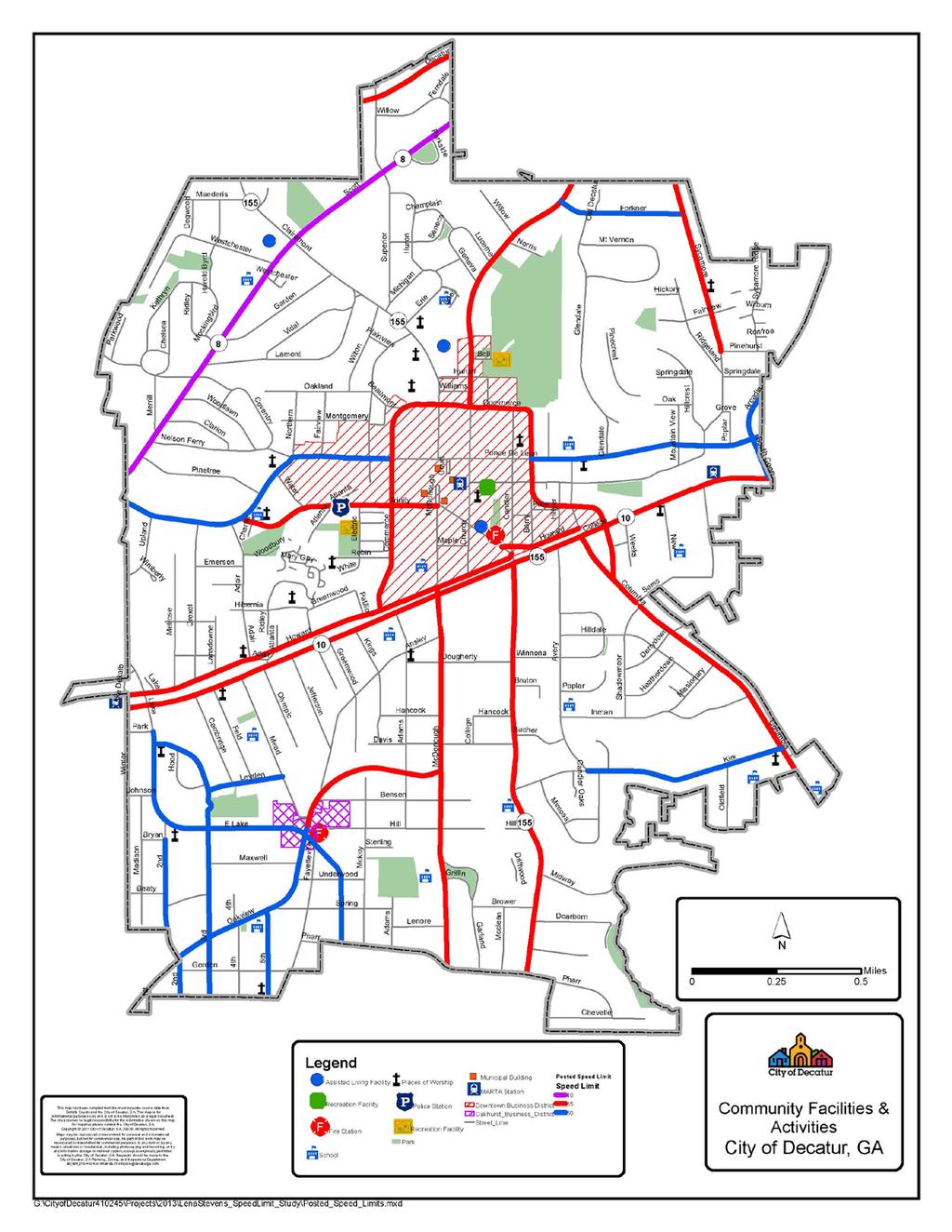
16 COMMUNITY FACILITIES With a population density of nearly 5,000 residents per square mile, community facilities and points of interest are spread throughout the City. These facilities include schools, places of worship, assisted living facilities, municipal buildings, parks, and other recreation facilities. Setting appropriate speed limits to protect the people who travel to these destinations helps increase safety while also encouraging active, healthy lifestyles. HIGHLIGHTS (SEE MAP ON NEXT PAGE) Facility Types Assisted Living Facilities- 3 K-12 Schools- 13 Higher Education- 5 Places of Worship- 20+ City Parks- 9 MARTA Rail Stations- 3 Business Districts- 3 Retail/Restaurant Locations Public Safety Facilities- 3 Schools located in close proximity to streets with high volumes of speeding violations: Renfroe Middle School College Avenue (SR 10) Agnes Scott College College Avenue (SR 10) Decatur High School College Avenue (SR 10) Westchester Elementary Scott Blvd. (SR 8) *reopens in 2014 Page 15
17 Page 16
18 INFRASTRUCTURE In addition to the education and outreach efforts, significant capital investment has been made in Decatur s pedestrian infrastructure.. Recently Decatur was awarded Bronze level certification in the Bike Friendly Communities Program and Silver level certification in the Walk Friendly Communities program. Encouraging and supporting alternative modes of transportation is a primary focus of the Community Transportation Plan. The City-wide sidewalk improvement program began in 2004 with funding from annual appropriations by the City Commission, and was further strengthened by a bond referendum approved in Additionally, the City hosts many events that promote alternate modes of transportation. HIGHLIGHTS (SEE MAP ON NEXT PAGE) Capital investments to facilitate alternative modes of transportation (approximate) o Sidewalks-$2M o Bike Lanes-$400,000 o Clif Shuttle- $3500 per year o G060+ Shuttle- $12,000 per year (pilot phase) o MARTA Plaza Redevelopment- $1M o Focused Neighborhood Traffic Calming Initiatives- Ponce de Leon Terrace South Columbia Drive, Ponce de Leon Court and the Great Lakes o Crosswalks o Paths/Trails o Agnes Scott crosswalk Biking & Walking Events/Promotions: o Employee Walking Works o Car Free Day o Sidewalk Saturdays o Walk and Roll to School o Walk there Decatur o Bike Training Page 17
19 Page 18
20 STREET TYPOLOGY Decatur s Community Transportation Plan identifies a street typology for each street in Decatur. The typology accounts for the street s function, the adopted land use, building form and mix of uses. Therefore, it is appropriate for target speed limits to be assigned based on the street typology.. Downtown Core streets are located within high density mixed use commercial, retail, office and residential areas with substantial pedestrian activity. They should accommodate bicyclists as vehicles and target reasonable motor vehicle speeds. Regional Boulevards are designed to balance traffic mobility and land access. Typically businesses are setback from the street and the emphasis for these corridors is not on pedestrian mobility as much as other typologies. Urban Mixed Use: No definition included in CTP Neighborhood Conservation streets carry more traffic than most residential local streets, but they must be safe for walkers and bicyclists by providing reasonable automobile travel speeds. Non-arterial Streets consists of Alleys, Residential Local Streets and Downtown Local Streets. Downtown Local Streets provide alternative rotes for congested areas in the downtown. Alleys are for loading goods for local business. Residential local streets provide not just a way to and from home but a shared space in the neighborhood for walking, biking conversing with neighbors. Page 19
21 Page 20

22 PROPOSAL The City of Decatur is proposing that the speed limits be comprehensively updated to better align with the typology identified in the Community Transportation Plan (CTP), to support the policy of improving public health and to recognize the community building aspects that are related to transportation policy. The CTP typology classification serves as an enhancement of the functional classification system currently used by Georgia Department of Transportation and is designed to more accurately represent the character of Decatur s community streets. Table 2: State Functional Classifications and Community Transportation Plan Street Typology Current Functional Community Transportation Plan Street Typology Classification System (GDOT) Urban Principal Arterials Urban Minor Arterials Urban Collectors Roads Arterials Regional Boulevard Downtown Core Urban Mixed Use Neighborhood Conservation Targeted Limit (mph) Non Arterials Medium and High Density Residential Low Density Residential Alley/Service Proposed Changes (See Map on Next Page) 1. All streets will have a speed limit of 25mph unless otherwise posted. This includes streets identified as Downtown Core, Neighborhood Conservation, or High/Medium/Low Density Residential. 2. Streets identified as Regional Boulevard change to 35mph. a. Scott Boulevard (SR 8) is the only Regional Boulevard. It has a current speed limit of 40mph. 3. Streets identified as Urban Mixed Use change to 30mph. a. College Avenue (SR 10) & Howard Avenue change 30mph despite their mixed designation as Urban Mixed Use and Neighborhood Conservation. b. Small street sections designated as Urban Mixed Use will revert to 25mph due to the short distance (ex. Trinity Place and East Lake Drive). c. Church Street is proposed to change to 25mph in light of the lane narrowing that occurred after the CTP was prepared. Page 21
23 Page 22
24 APPENDIX A: CURRENT STREET CLASIFICATIONS The following provides a summary of the current classification of Decatur s street network as collected from the Georgia Department of Transportation DeKalb County database. Urban Principal Arterials The City of Decatur has one principal arterial, Scott Boulevard (SR 8 & US29). It traverses the northwest corner of the City connecting downtown Atlanta to Stone Mountain and points further east. Urban Minor Arterials Decatur has good east-west and north-south connectivity provided for by a number of minor arterials. The City s minor arterials include: East/West College Avenue (SR 10 & US 278) East/West Howard Avenue East/West Ponce de Leon Avenue North Decatur Road Urban Collectors Second Avenue East Lake Drive South Candler Street (E. College south to Kirk Road) East Trinity Place Church Street North Arcadia Avenue South Candler Street (Kirk Road south to City limits) South Columbia Drive Commerce Drive Clairemont Avenue East Lake Road Local Roads The remaining streets in Decatur are considered local roads. The vast majority is located within the City s numerous single-family residential neighborhoods. State Routes within Decatur The City currently has 6.8 miles of State routes within the City limits, including the sections of the following roads which fall within the City s limits: State Route 8: Scott Boulevard State Route 155: Commerce Drive (from Clairemont Avenue east to College Avenue), Clairemont Avenue, South Candler Street State Route 10: College Avenue, Park Place (from East Lake Drive west to City limits), East Lake Drive (from City limits south to Park Place) Page 23
25 Page 24
26 APPENDIX B: COMMUNITY TRASNPORTATION PLAN STREET TYPOLOGY Page 25
Speed Limits Study and Proposal. Public Input Session: 8/14/13
 Speed Limits Study and Proposal Public Input Session: 8/14/13 Why is Decatur a unique place for this project? First Community Transportation Plan in the nation with a Health Impact Assessment. Strong sense
Perryville TOD and Greenway Plan
 Perryville TOD and Greenway Plan Greenway Glossary Pathway: A bicycle and pedestrian path separated from motorized vehicular traffic by an open space, barrier or curb. Multi-use paths may be within the
Community Transportation Plan Acknowledgements
 Community Transportation Plan Acknowledgements The Decatur CTP was developed with participation and guidance from City of Decatur staff, its Resident Boards and Commissions, and numerous residents, business
PEDESTRIAN ACTION PLAN
 ATTACHMENT 2 CITY OF SANTA MONICA PEDESTRIAN ACTION PLAN CITY OF SANTA MONICA PEDESTRIAN ACTION PLAN This page intentionally left blank EXECUTIVE SUMMARY CHAPTER 1 EXECUTIVE SUMMARY Setting the Stage
CITY OF COCOA BEACH 2025 COMPREHENSIVE PLAN. Section VIII Mobility Element Goals, Objectives, and Policies
 CITY OF COCOA BEACH 2025 COMPREHENSIVE PLAN Section VIII Mobility Element Goals, Objectives, and Policies Adopted August 6, 2015 by Ordinance No. 1591 VIII MOBILITY ELEMENT Table of Contents Page Number
City of Novi Non-Motorized Master Plan 2011 Executive Summary
 City of Novi Non-Motorized Master Plan 2011 Executive Summary Prepared by: February 28, 2011 Why Plan? Encouraging healthy, active lifestyles through pathway and sidewalk connectivity has been a focus
Chapter 2. Bellingham Bicycle Master Plan Chapter 2: Policies and Actions
 Chapter 2 Bellingham Bicycle Master Plan Chapter 2: Policies and Actions Chapter 2: Policies and Actions The Bicycle Master Plan provides a road map for making bicycling in Bellingham a viable transportation
CITY OF BLOOMINGTON COMPLETE STREETS POLICY
 CITY OF BLOOMINGTON COMPLETE STREETS POLICY POLICY OBJECTIVE: The City of Bloomington will enhance safety, mobility, accessibility and convenience for transportation network users of all ages and abilities,
CONNECTING PEOPLE TO PLACES
 CONNECTING PEOPLE TO PLACES 82 EAST BENCH MASTER PLAN 07 Introduction The East Bench transportation system is a collection of slow moving, treelined residential streets and major arteries that are the
Pathways to a Healthy Decatur
 CHAPTER 1 Pathways to a Healthy Decatur Health is a holistic sense of spiritual, mental, and physical well-being and the absence of illness and disease - a compilation of definitions of health by community
FINAL PLAN APPENDIX D CITY OF BERKELEY BIKE PLAN D-1
 CITY OF BERKELEY BIKE PLAN D-1 . Proposed Programs D.1. EDUCATION This appendix presents the recommended bicycle-related programs for the City of Berkeley. The recommendations are organized in four E s:
EXECUTIVE SUMMARY. Vision
 Vision Walking and bicycling in Salt Lake City will be safe, convenient, comfortable, and viable transportation options that connect people to places, foster recreational and economic development opportunities,
NM-POLICY 1: Improve service levels, participation, and options for non-motorized transportation modes throughout the County.
 Transportation PRINCE WILLIAM COUNTY 2008 COMPREHENSIVE PLAN NON-MOTORIZED PLAN CONTENTS Goals, Policies, and Action Strategies Table 4 (Bike Facility Classifications and Descriptions) Table 5 (Bike Facility
Appendix C 3. Bicycle / Pedestrian Planning
 Appendix C 3. Bicycle / Pedestrian Planning BICYCLE/PEDESTRIAN PLANNING 2005 Master Plan GOAL: Provide for safe and convenient bicycle and pedestrian circulation throughout the City. Develop a city-wide
Pedestrian. Identifying Important Pedestrian Routes. 7 Pedestrian CHAPTER 7
 CHAPTER 7 Pedestrian T he City of Decatur is a prime location for walking. Historic houses, tree lined streets, a range of fine shopping and restaurants, and a conveniently small size all help create an
Section 9. Implementation
 Section 9. Implementation The transportation system is just one of many aspects that must be carefully planned to maintain and enhance the quality of living in Cecil County. The Cecil County Bicycle Plan
The best indicator of an individual s and expanding access to parks and open space.
 Health & Wellness Create a Safe and Healthy Built Environment Artist s rendering, 2014 Health is important to Loveland residents, and stakeholders see the many strong connections between quality of life,
Living Streets Policy
 Living Streets Policy Introduction Living streets balance the needs of motorists, bicyclists, pedestrians and transit riders in ways that promote safety and convenience, enhance community identity, create
Goodlettsville Bicycle and Pedestrian Plan Executive Summary
 Goodlettsville Bicycle and Pedestrian Plan July 2010 In Cooperation with the Nashville Area Metropolitan Planning Executive Organization Summary Introduction Progressive and forward thinking communities
Bikeway action plan. Bicycle Friendly Community Workshop March 5, 2007 Rochester, MN
 Bikeway action plan Summary The was held on March 5, 2007 at the Rochester Mayo Civic Center. The workshop was hosted by Rochester-Olmsted County Planning Department in collaboration with the League of
ADOT Statewide Bicycle and Pedestrian Program Summary of Phase IV Activities APPENDIX B PEDESTRIAN DEMAND INDEX
 ADOT Statewide Bicycle and Pedestrian Program Summary of Activities APPENDIX B PEDESTRIAN DEMAND INDEX May 24, 2009 Pedestrian Demand Index for State Highway Facilities Revised: May 29, 2007 Introduction
Chapter 5. Complete Streets and Walkable Communities.
 Chapter 5. Complete Streets and Walkable Communities. 5.1 Description of Complete Streets. Cities throughout the world, and specifically the United States, are coming to embrace a new transportation and
Walkable Communities: National Best Practices and Applications in Memphis, TN
 Walkable Communities: National Best Practices and Applications in Memphis, TN Dr. Stephanie Ivey Assistant Professor Herff College of Engineering Department of Civil Engineering Agenda Walkable communities
RESOLUTION NO ?? A RESOLUTION OF THE CITY OF NEPTUNE BEACH ADOPTING A COMPLETE STREETS POLICY
 RESOLUTION NO. 2018-?? A RESOLUTION OF THE CITY OF NEPTUNE BEACH ADOPTING A COMPLETE STREETS POLICY WHEREAS, safe, convenient, and accessible transportation for all users is a priority of the City of Neptune
BIKE PLAN CONTENTS GATEWAY
 CONTENTS Acknowledgments...vii Great Rivers Greenway District Board of Directors... vii Great Rivers Greenway District Staff... vii Project Consultants... vii Committees... viii Citizens Advisory Committee
2015 Florida Main Street Annual Conference. Complete Streets Equal Stronger Main Streets
 WHAT ARE COMPLETE STREETS? CASE STUDIES COMPLETING YOUR MAIN STREET 2015 Florida Main Street Annual Conference St. Petersburg, Florida August 19, 2015 WHAT ARE COMPLETE STREETS? CASE STUDIES COMPLETING
o n - m o t o r i z e d transportation is an overlooked element that can greatly enhance the overall quality of life for the community s residents.
 N o n - m o t o r i z e d transportation is an overlooked element that can greatly enhance the overall quality of life for the community s residents. 84 Transportation CHAPTER 11 INTRODUCTION Transportation
ACTIVE TRANSPORTATION
 ACTIVE TRANSPORTATION Mobility 2040 Supported Goals Improve the availability of transportation options for people and goods. Support travel efficiency measures and system enhancements targeted at congestion
Solana Beach Comprehensive Active Transportation Strategy (CATS)
") Solana Beach Comprehensive Active Transportation Strategy (CATS) 3.0 Goals & Policies The Solana Beach CATS goals and objectives outlined below were largely drawn from the Solana Beach Circulation Element
Solana Beach Comprehensive Active Transportation Strategy (CATS) 3.0 Goals & Policies The Solana Beach CATS goals and objectives outlined below were largely drawn from the Solana Beach Circulation Element
Agenda. Overview PRINCE GEORGE S PLAZA METRO AREA PEDESTRIAN PLAN
 PRINCE GEORGE S PLAZA METRO AREA PEDESTRIAN PLAN May 28, 2008 Agenda Welcome and introductions Project overview and issue identification Planning context and strengths Design challenges and initial recommendations
Bicycle Master Plan Goals, Strategies, and Policies
 Bicycle Master Plan Goals, Strategies, and Policies Mobilizing 5 This chapter outlines the overarching goals, action statements, and action items Long Beach will take in order to achieve its vision of
Goal 3: Foster an environment of partnerships and collaboration to connect our communities and regions to one another.
 Non-Motorized Transportation Plan (NMTP) Draft Vision, Goal and,, Tri-County Regional Planning Commission (TCRPC) Purpose The purpose of the Tri-County Regional Planning Commission (TCRPC) Non-Motorized
Proposed. City of Grand Junction Complete Streets Policy. Exhibit 10
 Proposed City of Grand Junction Complete Streets Policy Exhibit 10 1 City of Grand Junction Complete Streets Policy Vision: The Complete Streets Vision is to develop a safe, efficient, and reliable travel
Safe Routes to School Blue Zones Project, City of
 Safe Routes to School Blue Zones Project, City of Fort Worth and FWISD Partnership Introduction to Blue Zones Project Blue ZonesProject is a well-being improvement initiative designed to make healthy choices
Community Transportation Plan
 Community Transportation Plan Appendix A: Traffic Calming CITY OF DECATUR COMMUNITY TRANSPORTATION PLAN Appendix A: City of Decatur City-wide Residential Traffic Calming Program Process & Procedures The
The Florida Bicycle and Pedestrian Partnership Council
 The Florida Bicycle and Pedestrian Partnership Council Input to the Update of the Florida Transportation Plan March 2015 This document presents input from the Florida Bicycle and Pedestrian Advisory Council
TOWN OF PORTLAND, CONNECTICUT COMPLETE STREETS POLICY
 TOWN OF PORTLAND, CONNECTICUT COMPLETE STREETS POLICY I. VISION, GOALS & PRINCIPLES VISION To improve the streets of Portland making them safer and more accessible for all users including pedestrians,
Bicycle and Pedestrian Plans and Improvements
 Bicycle and Pedestrian Plans and Improvements Presented to the City Council By Randle Harwood, Planning and Development, and Richard Zavala, Parks and Community Services September 24, 2013 Purpose Review
Madison Urban Area and Dane County. Bicycle Transportation Plan Summary. September Introduction. Bicycle Plan Scope and Planning Process
 Bicycle Transportation Plan Summary Madison Urban Area and Dane County Introduction September 2000 Bicycling is an important mode of transportation in the Madison urban area and countywide that is available
CHAPTER 7.0 IMPLEMENTATION
 CHAPTER 7.0 IMPLEMENTATION Achieving the vision of the Better Streets Plan will rely on the ability to effectively fund, build and maintain improvements, and to sustain improvements over time. CHAPTER
City of Elizabeth City Neighborhood Traffic Calming Policy and Guidelines
 City of Elizabeth City Neighborhood Traffic Calming Policy and Guidelines I. Purpose: The City of Elizabeth City is committed to ensure the overall safety and livability of residential neighborhoods. One
Goals, Objectives, and Policies
 Goals, Objectives, and Policies ADVISORY GROUP INPUT PUBLIC INPUT SNS PREVIOUS STUDIES RBPP Goals Vision Statement Southern Nevada will develop a safe, connected, and convenient walking and bicycling system
DRAFT. Table of Contents. Background
 Douglas County Table of Contents Existing Infrastructure 86 Funding 89 Policy and Program Recommendations 90 Infrastructure Recommendations 92 Conclusion 95 Background Home to 4,500 residents and Baker
Engineering and Traffic Investigation Providing Justification for Lowering Default Arterial and Non-Arterial Speed Limits
 Engineering and Traffic Investigation Providing Justification for Lowering Default Arterial and Non-Arterial Speed Limits August 2016 Overview Seattle is committed to improving public health and safety
PEDESTRIAN ACTION PLAN
 CITY OF SANTA MONICA PEDESTRIAN ACTION PLAN DRAFT OCTOBER 2015 City Council, February 23, 2016 Beth Rolandson, AICP Principal Transportation Planner Mobility Division, Planning and Community Development
NASHUA REGIONAL PLANNING COMMISSION REGIONAL BICYCLE AND PEDESTRIAN PLAN
 NASHUA REGIONAL PLANNING COMMISSION REGIONAL BICYCLE AND PEDESTRIAN PLAN June, 2005 Prepared by the Nashua Regional Planning Commission 2005 NRPC Regional Bicycle and Pedestrian Plan- JUNE 2005 ACKNOWLEDGEMENTS
CITY OF ELKO BICYCLE AND PATHWAY PLAN
 CITY OF ELKO BICYCLE AND PATHWAY PLAN INTRODUCTION: The City of Elko is intended to provide the basic framework for the development of a functional bicycle and pathway system for the community with connections
Rochester Area Bike Sharing Program Study
 roc bike share Rochester Area Bike Sharing Program Study Executive Summary ~ January 2015 JANUARY 2015 8484 Georgia Avenue, Suite 800 Silver Spring, MD 20910 3495 Winton Pl., Bldg E, Suite 110 Rochester,
Exhibit 1 PLANNING COMMISSION AGENDA ITEM
 Exhibit 1 PLANNING COMMISSION AGENDA ITEM Project Name: Grand Junction Circulation Plan Grand Junction Complete Streets Policy Applicant: City of Grand Junction Representative: David Thornton Address:
Decatur Past and Present
 CHAPTER 2 Decatur Past and Present T he following sections detail the physical and social characteristics that make Decatur the city it is today. It touches on history, population, destinations, natural
102 Avenue Corridor Review
 February 26, 2015 102 Avenue Corridor Review Transportation Association of Canada Road Safety Engineering Award Submission for the City of Edmonton Introduction Transportation Association of Canada Road
Film Guide for Educators. Designing for Safety
 Film Guide for Educators Designing for Safety Designing For Safety Key Concepts Speeding While Driving Speeding is the number one cause of injuries and deaths from driving. The main reasons are because
STREET AND HIGHWAY PLAN
 STREET AND HIGHWAY PLAN Introduction The street and highway system in the Winston-Salem Urban Area consists of thousands of miles of traffic carrying facilities, ranging from short local residential streets
PRINCE GEORGE S PLAZA METRO AREA PEDESTRIAN PLAN
 PRINCE GEORGE S PLAZA METRO AREA PEDESTRIAN PLAN May 28, 2008 Agenda Welcome and introductions Project overview and issue identification Planning context and strengths Design challenges and initial recommendations
CHAIR AND MEMBERS CIVIC WORKS COMMITTEE MEETING ON APRIL 25, 2016
 TO: FROM: SUBJECT: CHAIR AND MEMBERS CIVIC WORKS COMMITTEE MEETING ON APRIL 25, 2016 JOHN BRAAM, P. ENG. MANAGING DIRECTOR, ENVIRONMENTAL & ENGINEERING SERVICES AND CITY ENGINEER SCHOOL ZONE SPEED LIMIT
BUILDING THE CASE FOR TRAVEL OPTIONS IN WASHING TON COUNTY. Image: Steve Morgan. Image: Steve Morgan
 BUILDING THE CASE FOR TRAVEL OPTIONS IN WASHING TON COUNTY Image: Steve Morgan Image: Steve Morgan Image: TriMet Image: TriMet WHAT ARE TRAVEL OPTIONS PROGRAMS? Travel options programs encourage residents,
Table #6 VISION CHARACTERISTICS
 Table #6 VISION White Flint is a place to live, work, play, shop, and walk with sufficient density to encourage quality redevelopment. Vibrant streets and consistent streetscapes are important. CHARACTERISTICS
Brian D. Hare, P.E. Bureau of Design PennDOT PA APA Annual Conference Investing in a Sustainable Future October 5, 2009
 Brian D. Hare, P.E. Bureau of Design PennDOT 2009 PA APA Annual Conference Investing in a Sustainable Future October 5, 2009 1 What is Smart Transportation? Photographer: heyjude. Used through license
MASTER BICYCLE AND PEDESTRIAN PLAN
 VILLAGE OF NORTHBROOK MASTER BICYCLE AND PEDESTRIAN PLAN DRAFT PLAN OPEN HOUSE May 2, 2018 AGENDA 1. Community Engagement 2. Vision and Goals 3. General Structure of Plan 4. Recommendations Overview 5.
REGIONAL BICYCLE AND PEDESTRIAN DESIGN GUIDELINES
 REGIONAL BICYCLE AND PEDESTRIAN DESIGN GUIDELINES November 16, 2011 Deb Humphreys North Central Texas Council of Governments Bicycle and Pedestrian Advisory Committee Snapshot of the Guide 1. Introduction
PEDESTRIAN ACTION PLAN
 CITY OF SANTA MONICA PEDESTRIAN ACTION PLAN DRAFT OCTOBER 2015 Safe Streets Santa Monica, December 3, 2015 Beth Rolandson, AICP Principal Transportation Planner Strategic + Transportation Planning, Planning
Physical Implications of Complete Streets Policies
 Presentation Overview Physical Implications of Complete Norm Cox, ASLA, LLA Landscape Architect Ann Arbor, Michigan, 10:45 to Noon What Are Complete Streets? What Matters to Bicyclists and Pedestrians
Complete Streets Training. Georgia Municipal Association June 27, 2016
 Complete Streets Training Georgia Municipal Association June 27, 2016 Overview What are CS? GDOT s Policy Case Study 2 What are Complete Streets? According to the National Complete Streets Coalition, complete
CHAPTER 1 INTRODUCTION
 CHAPTER 1 INTRODUCTION Chapter Table of Contents THE 2017 HOUSTON BIKE PLAN 1-1 HOUSTON BIKEWAYS PROGRAM 1-2 HISTORY OF BICYCLE PLANNING IN HOUSTON 1-3 BICYCLE LEVEL OF COMFORT 1-3 EXISTING PLANS, PROGRAMS
The North Shore Transportation Improvement Strategy and Western Richmond Terrace 1 : The Forgotten Corridor
 Elm Park Civic Association Island Voice Do Me A Faber The North Shore Transportation Improvement Strategy and Western Richmond Terrace 1 : The Forgotten Corridor Introduction Richmond Terrace is the northernmost
Draft MOBILITY ELEMENET. Community Meeting May 22, 2013
 Draft MOBILITY ELEMENET Community Meeting May 22, 2013 Agenda Presentation Ira Brown New Mobility Paradigm Movement of People Implementation Q&A Ira Brown and Dave Roseman Small Group Discussion at Each
This page intentionally left blank.
 This page intentionally left blank. COMMUNITY Coweta Community Overview Coweta Coweta, a residential community located in Wagoner County, is a suburb of Tulsa situated southeast of the metropolitan area
City of San Diego Vision Zero Draft Strategic Plan FY 2017
 City of San Diego Vision Zero Draft Strategic Plan FY 2017 Engineering Objective: To develop and implement a strategy that employs best planning, design and engineering practices. Background: Over the
Multimodal Through Corridors and Placemaking Corridors
 68 Multimodal Through Corridors and Placemaking Corridors Corridors have different functions in a region. Some corridors are used to get smoothly and rapidly through a region or to get quickly to major
CHAPTER 3: Vision Statement and Goals
 Davidson Walks & Rolls: Active Transportation Master Plan CHAPTER 3 Contents: Overview Vision Statement Measurable Goals Public Outreach CHAPTER 3: Vision Statement and Goals Overview The vision statement
Chapter 7. Transportation. Transportation Road Network Plan Transit Cyclists Pedestrians Multi-Use and Equestrian Trails
 Chapter 7 Transportation Transportation Road Network Plan Transit Cyclists Pedestrians Multi-Use and Equestrian Trails 7.1 TRANSPORTATION BACKGROUND The District of Maple Ridge faces a number of unique
How to Develop a Pedestrian Safety Action Plan
 How to Develop a Pedestrian Safety Action Plan Course Introduction Presented by: Peter Eun FHWA RC Safety Engineer Ryan Snyder President, Ryan Snyder Associates, LLC Paul Zykofsky Director, Land Use and
Chapter 14 PARLIER RELATIONSHIP TO CITY PLANS AND POLICIES. Recommendations to Improve Pedestrian Safety in the City of Parlier (2014)
") Chapter 14 PARLIER This chapter describes the current status and future plans for biking and walking in the City of Parlier. RELATIONSHIP TO CITY PLANS AND POLICIES The Parlier General Plan is the primary
Chapter 14 PARLIER This chapter describes the current status and future plans for biking and walking in the City of Parlier. RELATIONSHIP TO CITY PLANS AND POLICIES The Parlier General Plan is the primary
Improve the livability of our streets by
 Pedestrian and Traffic Calming Policy March 2018 2 of 6 Neighborhood Traffic Calming Policy The City of Aspen continually strives to protect multimodal function while maintaining a high standard of safety.
East Burke Transportation, Safety and Capacity Improvements
 East Burke Transportation, Safety and Capacity Improvements The purpose of this project is to increase mobility and improve safety for pedestrians, cyclists, and motor vehicles along VT Route 114 in the
We believe the following comments and suggestions can help the department meet those goals.
 The Honorable Secretary Anthony Foxx The Secretary of Transportation United States Department of Transportation 1200 New Jersey Avenue, SE Washington, DC 20590 August 30, 2013 Dear Secretary Foxx, Thank
West Dimond Blvd Upgrade Jodhpur Street to Sand Lake Road
 West Dimond Blvd Jodhpur St to Sand Lake CSS Transportation Project Summary Municipality of Anchorage Project # 05 005 Project Manager: John Smith, P.E. (MOA PM&E) Project Administrator: Julie Makela,
Active Transportation Infrastructure Investment A Business Case
 Active Transportation Infrastructure Investment A Business Case In 2016, the Real Estate Foundation awarded the Capital Regional District a $50,000 grant for Shifting Gears: Land Use Change through Active
Non-Motorized Transportation 7-1
 Non-Motorized Transportation 7-1 Transportation facilities no longer mean just accommodating a vehicle powered by a combustion engine. Pedestrian and non-motorized facilities are important modes of travel
Transportation Master Plan Advisory Task Force
 Transportation Master Plan Advisory Task Force Network Alternatives & Phasing Strategy February 2016 BACKGROUND Table of Contents BACKGROUND Purpose & Introduction 2 Linking the TMP to Key Council Approved
Safe Routes to School in New Jersey
 Safe Routes to School in New Jersey The need for Safe Routes to School 1. Fewer kids today walk and bike to school 2. Unintended consequences have resulted 3. SRTS programs can be part of the solution
CITY MANUALS AND STANDARDS REVIEW
 GEORGETOWN SIDEWALK MASTER PLAN CITY MANUALS AND STANDARDS REVIEW RESOURCES AND STANDARDS As part of the Master Plan process, a review and evaluation of current City documents and policies relevant to
GRAHAM PEDESTRIAN TRANSPORTATION PLAN
 GRAHAM PEDESTRIAN TRANSPORTATION PLAN Chapter 1 I 1.1 Scope and Purpose n March of 2005, the City of Graham contracted with Greenways Incorporated (GWI) to create a Pedestrian Transportation Plan. The
Multi-Modal Transportation Programs
 Multi-Modal Transportation Programs Supporting the Lawrence Strategic Plan Critical Success Factors: Safe, Healthy and Welcoming Neighborhoods Innovative Infrastructure & Asset Management Effective Governance
WALK Friendly Communities: Creating Vibrant, Inclusive Places for People
 WALK Friendly Communities: Creating Vibrant, Inclusive Places for People Walkers are the indicator species for vibrant communities ~ Dr. Rodney Tolley, Director, Walk21 Imagine yourself walking safely
Non-motorized Transportation Planning Resource Book Mayor s Task Force on Walking and Bicycling City of Lansing, Michigan Spring 2007 pg.
 Non-motorized Transportation Planning Resource Book pg. 105 of 158 Non-motorized Transportation Planning Resource Book pg. 106 of 158 Non-motorized Transportation Planning Resource Book pg. 107 of 158
5 Circulation & Parking
 5 Circulation & Parking Downtown Parking & Circulation Strategy. Downtown Wayne has a somewhat disconnected system of local public streets to connect downtown with the residential neighborhoods, and primary
Safe Routes to School
 Safe Routes to School Amy Paxton-Aiken, Center TRT University of North Carolina Chapel Hill, NC and Ian Thomas, Executive Director PedNet Coalition Columbia, MO Housekeeping If you are calling in on a
CITY OF ALPHARETTA DOWNTOWN MASTER PLAN TRAFFIC EVALUATION
 CITY OF ALPHARETTA DOWNTOWN MASTER PLAN TRAFFIC EVALUATION June 2015 CITY OF ALPHARETTA DOWNTOWN MASTER PLAN TRAFFIC EVALUATION Introduction The Alpharetta Downtown Master Plan was developed in the fall
Traffic Impact Memorandum. May 22, 2018
 BISHOP PROFESSIONAL DEVELOPMENT BUILDING Proposed Land-use Change & Parking Modification 3601 SW 31st Street Topeka, Kansas 66614 CFS Project No. 185077 Traffic Impact Memorandum May 22, 2018 Prepared
About the Active Transportation Alliance
 About the Active Transportation Alliance Chicagoland s voice for better biking, walking and transit Founded 1985 7,000 members, ~33 full time staff Serve Chicago metro region 1 More Cars, More Driving
Transit. Transit Ridership in Decatur. 9 Transit CHAPTER 9
 CHAPTER 9 Transit D ecatur is in the unique and fortunate position to be very well served by transit. Located within its compact 4.2 square miles are three heavy rail stations, numerous bus routes, and
FEDERAL HIGHWAY ADMINISTRATION APPLICATION
 FEDERAL HIGHWAY ADMINISTRATION APPLICATION REQUEST FOR PERMISSION TO EXPERIMENT WITH A BICYCLE BOX INTERSECTION TREATMENT Submitted by: City of Columbus Department of Public Service Date: June 26, 2009
SANTA CLARA COUNTYWIDE BICYCLE PLAN August 2008
 SANTA CLARA COUNTYWIDE BICYCLE PLAN August 2008 To assist VTA and Member Agencies in the planning, development and programming of bicycle improvements in Santa Clara County. Vision Statement To establish,
Toward Zero Deaths. Regional SHSP Road Show Meeting. Virginia Strategic Highway Safety Plan. presented by
 Toward Zero Deaths Regional SHSP Road Show Meeting presented by Virginia Strategic Highway Safety Plan December 1, 2016 1 Welcome & Introductions Purpose of the Meeting Objectives & Key Outcomes Agenda»
MARKET/JFK VISION ZERO PILOT PROJECT FEBRUARY 2019 EVALUATION REPORT
 MARKET/JFK VISION ZERO PILOT PROJECT FEBRUARY 2019 EVALUATION REPORT WHY IS THIS PROJECT IMPORTANT? Market Street and JFK Boulevard in Center City are key east-west corridors in the core business district.
5.0 Roadway System Plan
 Southwest Boise Transportation Study Page 16 5.0 Roadway System Plan The Roadway System Plan outlines roadway improvements in the Initial Study Area. It forecasts future deficiencies on the arterial system,
Transportation Assessment
 Transportation Assessment Midtown Open House February 10, 2018 Overview Midtown in Focus Overview & Purpose of Today Transportation Assessment overview Summary of Transportation work to date Review & Analysis
2014 Bellingham Bicycle Master Plan
 2014 Bellingham Bicycle Master Plan Acknowledgements The City of Bellingham is honored by the commitment of the numerous community members and bicycling enthusiasts who participated in the development
Tonight is for you. Learn everything you can. Share all your ideas.
 Strathcona Neighbourhood Renewal Draft Concept Design Tonight is for you. Learn everything you can. Share all your ideas. What is Neighbourhood Renewal? Creating a design with you for your neighbourhood.