Engineering and Traffic Investigation Providing Justification for Lowering Default Arterial and Non-Arterial Speed Limits
|
|
|
- Dora Kelley
- 6 years ago
- Views:
Transcription
1 Engineering and Traffic Investigation Providing Justification for Lowering Default Arterial and Non-Arterial Speed Limits August 2016 Overview Seattle is committed to improving public health and safety through Vision Zero, the city s aspirational initiative to eliminate fatalities and serious injuries on Seattle s streets by At the core of this initiative is the belief that death and injury on city streets is preventable and acknowledging the importance of street design in mitigating the frequency and severity of collisions. The city of Seattle is an increasingly dense urban environment with more than 1,000,000 daily motor vehicle trips, thousands of daily pedestrian and bike trips, and approximately 400,000 daily transit trips. More than 10,000 collisions occur on Seattle streets annually. Less than 10 percent of these crashes involve pedestrians, bicyclists or motorcycles yet these modes make up more than 50 percent of fatalities. Vehicular speed is often the critical factor for survival in collisions. The higher a driver s speed, the greater risk to vulnerable road users. While we can engineer for safer streets, Vision Zero acknowledges that human beings are fallible. In just the last three years, collisions attributed to inattention increased 280 percent in Seattle and contributed to more than 3,000 crashes in 2014 alone. With each crash, speed makes the difference between no injury, minor injury, serious injury or death. In an effort to improve safety for everyone that uses Seattle s transportation systems, the Seattle Department of Transportation (SDOT) proposes the following changes to the Seattle Municipal Code (SMC) regarding speed limits: Non-arterial speed limit reduction from 25 miles per hour (mph) to 20 mph (SMC ) Default speed limit reduction for unsigned arterial streets from 30 mph to 25 mph (SMC ) These amendments to the SMC will be consistent with Washington State code and Federal Highway Administration (FHWA) recommendations. Lower speed limits have been shown to be safer for our most vulnerable populations. According to a recent World Health Organization (WHO) report, legislation on road safety is a critical piece in reducing road traffic crashes, injuries and deaths 1. The following report provides the engineering justification for lower non-arterial and default speed limits. 1 WHO Global Status Report on Road Safety 2015
2 Background The primary purpose of having a speed limit is to enhance road safety for everyone. Setting an appropriate speed limit: Alerts drivers about the environment ahead speed limits generally reflect the geometric design of the street and adjacent land uses as well as the amount of on-street parking, driveways, and pedestrian and bicycle activity Enhances safety for everyone Setting appropriate speed limits reduces the probability and severity of crashes under favorable roadway and environment conditions Provides regulatory framework Speed limits allow law enforcement and the municipal court system the governing context for controlling speeds As far back as 1927 (as far as is catalogued in the Municipal archives) the city established a maximum speed limit of 25 mph on all city streets. 2 For arterial highways Seattle deferred to the state of Washington, which set all arterial highway speed limits in Seattle. At this time streets and highways were just starting to develop into what we understand today the first traffic signal in Seattle was installed in 1924 at 4 th Ave S and S Jackson St. Until 1934 speed limits on arterial highways in Seattle were relegated to the state. Beginning in 1934, the city began including a handful of arterials in the traffic code with 35mph limits 3. These streets included important routes such as Empire Way (now MLK Jr Way), E Marginal Way, and Westlake Ave. Between 1934 and 1948 the traffic code added and removed individual streets to this 35mph list through a series of ordinances. In 1948 Seattle updated the traffic code to reflect the current default speed limit regulations we know today 30 mph default arterial speed limit and 25 mph on all other streets, unless otherwise marked 4. Seattle s Vision Zero Initiative, which launched in 2015, places emphasis on safety for bicyclists and pedestrians. Safety for vehicle drivers and passengers has improved substantially over the last decade but safety for vulnerable users has not experienced the same positive trend. Furthermore, the likelihood of injury is high for pedestrians or bicyclists involved in collisions. The injury rate for pedestrians involved in collisions is 77 percent and 83 percent for bicyclists involved in collisions. 5 2 Ordinance Ordinance Ordinance Seattle Department of Transportation 2015 Traffic Report,
3 Seattle s transportation infrastructure serves an increasing amount of vulnerable users like pedestrians and bicyclists. Non-motorized and trips taken by transit continue to increase and rose 7 percent and 5 percent respectively between 2012 and in the City Center. SDOT has also tracked increasing pedestrian and bicycle counts at most locations counted through the National Bicycle and Pedestrian Documentation project. 7 While increasing non-motorized and transit trips improves the efficiency of our transportation network, studies demonstrate the negative effects of higher driving speeds. For instance, the cognitive abilities of drivers decline at higher speeds. Without factoring in behavioral issues like distracted driving, drivers becomes less aware of surroundings as speed increases and our ability to process information is limited by our field of view. An increase in travel speed increases the stopping distance of a vehicle, decreases the driver s field of vision and results in less time for the driver to react to a person or hazard in the roadway Center City Commuter Mode Split Survey, Commute Seattle (2016) Traffic Report, Seattle Department of Transportation, 8 Street Environment, Driving Speed and Field of Vision by A. Bartmann, W. Spijker & M. Hess (1991)

4 Injuries for vulnerable road users increase in severity as vehicle speeds increase. When a person is struck at a high rate of speed, a proportion of the vehicle s kinetic energy is transferred to the human body. Kinetic energy is determined by the square of the vehicle s speed 9, rather than by speed alone. If a vehicle were traveling 20 percent faster along an arterial (e.g. from 25 mph to 30 mph), the kinetic energy increases by 44 percent, or more than doubling the risk of injury due to the greater amount of energy the vulnerable person in the roadway has to absorb. For reference, the human tolerance for a pedestrian struck by a well-designed car will be exceeded if the vehicle is traveling at over approximately 20 mph EE KK = 1 2 mmvv2, where EE KK = Kinetic Energy, m = mass of object, and v = speed of object 10 Tingvall, C. and Haworth, N. (1999) Vision Zero - An ethical approach to safety and mobility, Paper presented to the 6th ITE International Conference Road Safety & Traffic Enforcement: Beyond 2000, Melbourne, 6-7 September 1999 (

5 Furthermore, behavioral issues like inattention increase the likelihood of collisions and data show an alarming trend in the number of collisions attributed to driver distraction. In Seattle, inattention-related collisions increased 280 percent between 2011 and Lower speed limits will minimize injuries when these mistakes like this occur and will help improve public safety in Seattle. The benefits of this speed limit reduction proposal are consistent with city and SDOT policies. Reduce collisions that result in injuries, serious injuries and fatalities through Vision Zero, the city is committed to a goal of ending all serious injuries and fatalities on city streets by Speed is a contributing cause of death and serious injury on Seattle streets. Reduce collisions and provide a cost savings to society AAA 11 estimates that each serious collision costs taxpayers roughly $6 million, based on the FHWA comprehensive costs for serious injuries and fatalities. These costs are based on 11 components which include: property damage; lost earnings; lost household production (non-market activities occurring in the home); medical costs; emergency services; travel delay; vocational rehabilitation; workplace costs; administrative costs; legal costs; and pain and lost quality of life. A safer city encourages a healthier city Streets that feel safer may encourage more active forms of transportation, such as walking and biking. Reducing the speed limit for vehicles will make vulnerable users more comfortable with using our transportation infrastructure, and create more opportunities for physical activity. Additionally, lower vehicle speeds mean reduced noise pollution from the road and foster more vibrant communities, such as neighborhoods lined with small businesses. Safer streets encourage more non-motorized travel Streets that feel safer may help the city achieve mode share goals and improve the efficiency of the transportation network. Seattle currently administers programs to promote transit use, ridesharing, bicycle trips, and walking and biking to school. 11 Crashes vs. Congestion What s the Cost to Society (AAA, November 2011)
6 Speed Limit Proposal Non-arterial Speed Limit Reduction Justification Existing non-arterial speed limit: 25 mph Proposed non-arterial speed limit: 20 mph To enhance safety for vulnerable users on non-arterial streets, SDOT proposes to amend SMC to reduce the speed limit on non-arterial streets from 25 mph to 20 mph. This change would affect all of Seattle s 2400 miles of non-arterial streets as shown in maps 1 and 2. Reducing the speed limit on nonarterials is consistent with Washington s Neighborhood Safe Streets Law (2013) which authorizes municipalities to lower limits to 20 mph. Seattle s non-arterial streets (commonly referred to as residential or local streets) are designed for low speeds. The standard residential street in Seattle is 25 feet wide with 7-foot wide parking lanes on both sides of the street. This leaves one 11 foot-wide general purpose travel lane for vehicles. Two vehicles travelling in opposite directions on a standard non-arterial street must take turns navigating the street. The width of our non-arterials maintains low speeds on these roadways. While the frequency of collisions on non-arterial streets is relatively low, nearly 3600 collisions occur on these roadways each year. Approximately 10 percent of annual serious injury and fatal collisions occur on these streets. Annual Collisions on Non-arterial Streets (3 year average) Total Collisions Injuries Serious Injuries Fatalities Speed limit signs are not posted on non-arterial streets unless the street passes through a special designation area such as a school zone or 20 mph zone. The non-arterial speed limit will be posted on signage at major entrances to the city as described later in this document. Case Study Slow Zones Countries around Europe have started implementing Slow Zones which sets the speed limit at 20 mph to slow traffic down on non-arterial streets in neighborhoods. After implementing Slow Zones, the following safety impacts were noticed 12 : 12 NACTO Neighborhood Slow Zones A community-driven approach to reducing speeds to 20MPH ( pdf)
7 London 46% reduction in collisions. Average speeds also reduced by 9 mph. In another study 13, there was a 41.9% reduction in fatalities and serious injuries where the reduction was greatest in younger children under 15 years old New York City started implementing Slow Zones in Since then, their findings show promising trends 14 : 10-15% reductions in speeds 14% overall reduction in crashes with injuries 31% reduction in driver or passenger injuries On September 8, 2015, SDOT formally announced the 20 mph zone program to improve neighborhood safety for all travelers near schools and playgrounds. This pilot program is consistent with our current city laws based on SMC SDOT reduced non-arterial speed limits to 20 mph at six pilot locations in 2015 based on collision history, number of nearby pedestrian generators, geographical representation, and partnership opportunities. There are two phases to this neighborhood 20 mph zone program: Phase One Install 20 MPH signs and 20 MPH markings on the street. Phase Two If speeds are not reduced with signs, install other safety improvements such as curb bulbs, speed humps, and other appropriate traffic calming devices. Speeds were reduced by a maximum of 1.6 mph and collisions dropped in five out of the six 20 MPH zones. 13 Effect of 20 mph traffic speed zones on road injuries in London, : controlled interrupted time series analysis (BMJ 2009;339:b4469) 14

8 Map 1 Existing non-arterial speed limits

9 Map 2 Proposed Speed Limits for Non-arterial Streets
10 Default Arterial Speed Limit Reduction Justification Existing default arterial speed limit: 30 mph Proposed default arterial speed limit: 25 mph SDOT proposes to amend SMC to reduce the default arterial speed limit from 30 mph to 25 mph. Reducing the default arterial speed limit will make Seattle s speed limit consistent with the Washington state speed limit of 25 mph for city streets 15. Of the 39 cities within King County, Seattle is the only city with a default speed limit higher than 25 mph. Other major cities that have a default arterial speed limit of 25 mph or lower include: London, Paris, Tokyo, New York City, Phoenix and Portland, Oregon. The city of Boston reduced their default speed limit to 20 mph. The default speed limit is in effect on streets where the speed limit is not posted or where signs are missing or illegible. Streets where the default arterial speed limit is currently in effect include areas of the Central Business District, South Lake Union, Lower Queen Anne, the International District and portions of Capitol Hill and First Hill west of 23 rd Avenue. Current operating speeds for vehicular traffic in study area (85 th percentile): 22 to 25 mph Changing the default arterial speed limit to 25 mph would be complaint with Federal Highway Safety Administration 16 guidance for setting speed limits. Engineering improvements have been implemented to support existing vehicle speeds. In 2015 and 2016, SDOT retimed and coordinated more than 300 signals in the areas where the default speed limit is currently in effect. Vehicular traffic speeds were determined for arterial streets. Current operating speeds range from 22 to 25 mph below the default speed limit of 30 mph. A 25 mph design speed was used for SDOT s signal timing and coordination project. This signal design has been in operation since January SDOT is prepared to install or replace nearly 500 signs to highlight the new speed limits upon passage of legislation. More information about signage changes can be found later in this report. The proposed reduction to the default speed limit would become effective immediately upon acceptance of this proposal in central Seattle. The default speed limit reduction is intended to address an increase in crash severity in this area. More than 9000 collisions occur on Seattle s arterial streets annually. These roadways are typically wide (40 feet wide or greater) and designed to accommodate transit, freight and higher traffic volumes. The majority of arterial streets have posted speed limits of 30 mph or higher. Given higher vehicular speeds and traffic volumes for all modes on these roadways, there is greater opportunity for conflicts. 15 RCW Basic rule and maximum limits 16 Methods and Practices for Setting Speed Limits: An Informational Report, FHWA, 2012
11 Average Annual Collisions on Arterial Streets (3 year average) Total Collisions Injuries Serious Injuries Fatalities percent of serious injuries and fatal collisions occur on our arterial street network and speed has become an increasingly significant contributing factor in central Seattle. Although a small land area, this area has concentrated a collision frequency 6 times of land area percent. Speed has been involved in a greater proportion of fatal collisions over the last decade. In general, speed contributed to 4 percent of annual collisions in downtown but 42 percent of fatal crashes in downtown Seattle from Collision data show that the majority of the serious, speed-related collisions occur during the evening after the heavy traffic volumes subside. Lower volumes make attaining higher speeds possible. Please note that the data below relies on a relatively small sample size due to the fact that few traffic fatalities occur in Seattle. Because of its sample size, this data is only one of the factors supporting the City s decision. Collisions and severity: Central Seattle and citywide

12 Changing the default arterial speed limit will impact the Central Business District, South Lake Union, Lower Queen Anne, the International District and portions of Capitol Hill and First Hill west of 23 rd Avenue. See the maps below to view existing arterial speed limits and the specific areas where the default speed limit will take effect with this proposed change to the Seattle Municipal Code. Map 3 Existing Arterial Speed Limits

13 Map 4 Proposed Default Arterial Speed Limit Changes

14 Case Study - New York City Since 1965, New York City has had a speed limit of 30 mph 17. On November 7, 2014, New York lowered their default speed limit from 30 mph to 25 mph in an effort to reduce serious injuries and fatalities 18. The default arterial speed limit is in effect on 90 percent of arterial streets. The remaining 10 percent of arterials continue to have higher posted speed limits while the New York City Department of Transportation (NYCDOT) reviewed select arterials for speed limit reductions. While New York s speed limit changes have been in place for less than two years, collision data show that this change has contributed to promising safety trends. Most importantly, the total number of pedestrian injury collisions substantially dropped for four of the five boroughs following the speed limit reduction
15 Arterial Speed Limits This proposal does not suggest altering the process for adjusting speed limits on arterial streets where the speed limit signs are posted. Posted speed limits adjustments typically occur after geometric design changes are implemented and only after engineering studies validate adjustment in accordance with national guidelines for setting speed limits 19. Adjustments to the posted speed limit require approval from the City Traffic Engineer. The Seattle Department of Transportation currently maintains a multi-year program to review posted speed limits on arterial streets. Review of posted speed limit will occur as budget and other demands on the department will allow. Changes to posted speed limits will be recommended if the City s review, including engineering studies, support such changes. Conclusion The Seattle Department of Transportation and the City Traffic Engineer propose to amend the Seattle Municipal Code to reduce the speed limit on non-arterial streets from 25 mph to 20 mph. SDOT and the City Traffic Engineer also propose to reduce the default arterial speed limit from 30 mph to 25 mph given that: Existing vehicular speeds in the areas impacted by this change are within accepted guidance set by the FHWA for setting speed limits There has been an increase in speed-related fatal collisions in central Seattle Higher vehicular speeds increase collision severity Engineering improvements have been made in the areas impacted by this change to support the 25 mph speed limit Additional signage improvements will be installed to inform drivers of the speed limits Additional arterial speed limit adjustments will be considered through SDOT s annual programs and adjustments will be made in accordance with national guidelines for setting speed limits Implementation methodology Seattle s speed limits have not substantially changed in decades. SDOT will coordinate a multifaceted approach to help educate residents and visitors about lower the speed limits. Effectively lowering the speed limits will be accomplished through the following: Education Installing new signs throughout the city to remind residents and visitors of the new default arterial speed limits Engineering Signal adjustments will reinforce the new default arterial speed limits Enforcement SDOT and the Seattle Police Department (SPD) coordinate on a monthly basis to deploy SPD to areas where we need to target driver behavior that puts those around them at risk 19 Methods and Practices for Setting Speed Limits: An Informational Report, FHWA, 2012


16 Evaluation Seattle evaluates the health of their transportation system on an annual basis through the public facing Annual Traffic Report. We will continue to evaluate the effectiveness of our policies and approaches through this report Engineering Seattle s arterial street network outside of the downtown core is lined with speed limit signs at regular intervals. Seattle currently posts speed limit signage at major and minor arterial entrances to the city. Variability in speed limit sign placement is due to site conditions along each roadway. In order to educate people about the new speed limits, SDOT will install 75 to 100 new signs. Gateway signs will be placed at 40 locations citywide and provide the default arterial speed limit as well as the non-arterial speed limit. These new signs will be posted where people enter Seattle including near the city limits and near highway off-ramps where visitors may be visiting from outside of Seattle: SEATTLE SPEED LIMITS ARTERIAL 25 NON-ARTERIAL 20 UNLESS OTHERWISE POSTED Existing gateway signs located near city limits New gateway signs Smaller signs with speed limits will be posted on minor arterial entries to Seattle. There are currently 38 existing signs posted citywide that SDOT will remove and replace. Existing signs located near city limits on minor arterials New signs
 Neighborhood Traffic Program, more than 400 advisory 20 mph speed limit signs have been installed on non-arterial streets.")
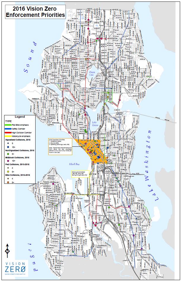
17 SDOT will continue to ensure that speed limit signs are posted regularly on arterials outside of downtown through annual maintenance programs. Through the Seattle Department of Transportation s (SDOT) Neighborhood Traffic Program, more than 400 advisory 20 mph speed limit signs have been installed on non-arterial streets. With the lower nonarterial speed limit, the advisory speed limit signs will be removed to remain in compliance with the Manual on Uniform Traffic Control Devices (MUTCD). Existing 20 mph advisory speed limit signs will be removed Enforcement The Seattle Police Department (SPD) is committed to the city s Vision Zero goal. SDOT and SPD meet regularly to discuss trends and enforcement priorities. Speeding is a top citation issued by SPD annually and Seattle will continue to use enforcement to reinforce the posted speed limit. Enforcement priorities are determined by speed and collision data. SDOT and SPD work to ensure that enforcements occur throughout the city but target the areas where speeding has contributed to collisions more often. Common locations for speed limit enforcements include arterial corridors, locations identified through SDOT s High Collision Evaluation Program and school zones. Priority enforcement locations for 2016 are shown in the map below:
18
19 Education In addition to the new signage noted above, the city will conduct a comprehensive public outreach campaign to educate drivers about the speed limit changes. Outreach methods will include earned media, newspaper and radio ads, social media messages and online resources. Implications Lowering speed limits may foster a public perception of decreased mobility for increased safety on our arterial street network. However, the actual impact to vehicular travel times are minimal considering the safety benefits of lower speeds. The average trip by car is 3.5 miles. Reducing the speed limit from 30 mph to 25 mph would add 1.4 minutes to the average trip. Speed (mph) Time to Travel One Mile (mins) There will be a transition period as more drivers within Seattle become accustomed to the lower speed limit; however, education campaign and targeted police enforcement to help change the driver behavior and reinforce the speed limits. Safer neighborhoods results in benefits to the quality of life for everyone. Road safety improves the transportation system, which impacts people's reach for opportunities in jobs, education, and a better life. For businesses and communities, reducing speeds may reduce road noise which can promote public health and growth for economic centers. Seattle has also established the Housing Affordability and Livability Agenda (HALA) initiative to keep Seattle affordable and not displace families.
Why Zone In on Speed Reduction?
 Learn it. Do it. Live it! SPEED REDUCTION IN THE ZONE Why Zone In on Speed Reduction? Speeding is a serious issue that plays a major role in the risk of serious injury and pedestrian fatality in a crash.
Borough of Danville, PA Traffic Calming Program Guidelines
 Borough of Danville, PA Traffic Calming Program Guidelines Adopted by Borough Council on 1 INTRODUCTION Speeding Traffic is a major concern in the Borough of Danville because of its detrimental impacts
City of San Diego Vision Zero Draft Strategic Plan FY 2017
 City of San Diego Vision Zero Draft Strategic Plan FY 2017 Engineering Objective: To develop and implement a strategy that employs best planning, design and engineering practices. Background: Over the
NACTO Designing Cities 2014 Dongho Chang, City Traffic Engineer October 23, 2014
 NACTO Designing Cities 2014 Dongho Chang, City Traffic Engineer October 23, 2014 Presentation overview Perspective on Safety Changing needs of our cities How Seattle is meeting those needs Challenge for
REGIONAL BICYCLE AND PEDESTRIAN DESIGN GUIDELINES
 REGIONAL BICYCLE AND PEDESTRIAN DESIGN GUIDELINES November 16, 2011 Deb Humphreys North Central Texas Council of Governments Bicycle and Pedestrian Advisory Committee Snapshot of the Guide 1. Introduction
TOWN OF PORTLAND, CONNECTICUT COMPLETE STREETS POLICY
 TOWN OF PORTLAND, CONNECTICUT COMPLETE STREETS POLICY I. VISION, GOALS & PRINCIPLES VISION To improve the streets of Portland making them safer and more accessible for all users including pedestrians,
Bicycle Master Plan Goals, Strategies, and Policies
 Bicycle Master Plan Goals, Strategies, and Policies Mobilizing 5 This chapter outlines the overarching goals, action statements, and action items Long Beach will take in order to achieve its vision of
SPEED MANAGEMENT FOR VISION ZERO
 SPEED MANAGEMENT FOR VISION ZERO LUANN HAMILTON, DEPUTY COMMISSIONER FOR PROJECT DEVELOPMENT CHICAGO DEPARTMENT OF TRANSPORTATION NACTO DESIGNING CITIES 2017 Vision Zero Action Plan Speed management and
CHAIR AND MEMBERS CIVIC WORKS COMMITTEE MEETING ON APRIL 25, 2016
 TO: FROM: SUBJECT: CHAIR AND MEMBERS CIVIC WORKS COMMITTEE MEETING ON APRIL 25, 2016 JOHN BRAAM, P. ENG. MANAGING DIRECTOR, ENVIRONMENTAL & ENGINEERING SERVICES AND CITY ENGINEER SCHOOL ZONE SPEED LIMIT
Public Information Centre
 WELCOME Public Information Centre Father Tobin Road Lougheed Middle School - Library Wednesday November 7, 2012 7:00 p.m.to 9:00 p.m. Please sign in Neighbourhood Traffic Calming Guide Background The City
City of Novi Non-Motorized Master Plan 2011 Executive Summary
 City of Novi Non-Motorized Master Plan 2011 Executive Summary Prepared by: February 28, 2011 Why Plan? Encouraging healthy, active lifestyles through pathway and sidewalk connectivity has been a focus
NYC Pedestrian Safety Study & Action Plan. NYTMC Brown Bag Lunch Presentation December 15, 2010
 NYC Pedestrian Safety Study & Action Plan NYTMC Brown Bag Lunch Presentation December 15, 2010 1 Introduction DOT Safety Goal Strategic Plan: Reduce Fatalities by 50% by 2030 From 274 (2007) to 137 (2030)
Welcome! San Jose Avenue Open House August 25, 2015
 Welcome! San Jose Avenue Open House August 25, 2015 Vision Zero The City and County of San Francisco adopted Vision Zero San Francisco Vision Zero High Injury Network as a policy in 2014, committing an
Speed Limits in the Hoddle Grid
 Speed Limits in the Hoddle Grid Recent History of speed limits March 2013 Docs # 7738485 1 Introduction Muncipalities have power to Erect speed limit signs BUT Municipalities DO NOT have the power to approve
Active Transportation Infrastructure Investment A Business Case
 Active Transportation Infrastructure Investment A Business Case In 2016, the Real Estate Foundation awarded the Capital Regional District a $50,000 grant for Shifting Gears: Land Use Change through Active
DOWNTOWN MIAMI PEDESTRIAN PRIORITY ZONE
 DOWNTOWN MIAMI PEDESTRIAN PRIORITY ZONE AUGUST 6, 2013 DOWNTOWN MIAMI BY THE NUMBERS more than 200,000 people live, work, and play here every day is home to more than 1,000 events each year hosts more
Chapter 2. Bellingham Bicycle Master Plan Chapter 2: Policies and Actions
 Chapter 2 Bellingham Bicycle Master Plan Chapter 2: Policies and Actions Chapter 2: Policies and Actions The Bicycle Master Plan provides a road map for making bicycling in Bellingham a viable transportation
VILLAGE OF NILES TRAFFIC CALMING POLICY
 INTRODUCTION There is increasing interest across the country in developing new strategies to reduce the speed and amount of traffic in residential neighborhoods. Measurement of speeds, traffic volumes,
Thank you for this opportunity to discuss with you how we can work together to make our streets more complete.
 Thank you for this opportunity to discuss with you how we can work together to make our streets more complete. 1 2 3 Thank you for this opportunity to discuss with you how we can work together to make
DEPARTMENT OF ENVIRONMENTAL SERVICES. North Harrison Street (Lee Highway to Little Falls Road) Comparative Analysis. Prepared for:
 Comparative Analysis. Prepared for:") DEPARTMENT OF ENVIRONMENTAL SERVICES North Harrison Street (Lee Highway to Little Falls Road) Comparative Analysis Prepared for: Arlington County Department of Environmental Services 2100 Clarendon Boulevard,
DEPARTMENT OF ENVIRONMENTAL SERVICES North Harrison Street (Lee Highway to Little Falls Road) Comparative Analysis Prepared for: Arlington County Department of Environmental Services 2100 Clarendon Boulevard,
AMATS Complete Streets Policy
 AMATS Complete Streets Policy Table of Contents: Section 1. Definition of Complete Streets Section 2. Principles of Complete Streets Section 3. Complete Streets Policy Section 4. Consistency Section 5.
BUILDING THE CASE FOR TRAVEL OPTIONS IN WASHING TON COUNTY. Image: Steve Morgan. Image: Steve Morgan
 BUILDING THE CASE FOR TRAVEL OPTIONS IN WASHING TON COUNTY Image: Steve Morgan Image: Steve Morgan Image: TriMet Image: TriMet WHAT ARE TRAVEL OPTIONS PROGRAMS? Travel options programs encourage residents,
Pedestrian & Bicycle Safety Innovations & Applications
 Pedestrian & Bicycle Safety Innovations & Applications County Engineers Association of Maryland Spring, 2017 Conference May 25, 2017 George Branyan Pedestrian Program Coordinator District Department of
Multi-Modal Transportation Programs
 Multi-Modal Transportation Programs Supporting the Lawrence Strategic Plan Critical Success Factors: Safe, Healthy and Welcoming Neighborhoods Innovative Infrastructure & Asset Management Effective Governance
CTDOT Pedestrian and Bicycle Safety Initiatives
 CTDOT Pedestrian and Bicycle Safety Initiatives 2017 Northeast Transportation Safety Conference Mark F. Carlino, P.E. Traffic Engineering Division Chief Bureau of Engineering and Construction Connecticut
We believe the following comments and suggestions can help the department meet those goals.
 The Honorable Secretary Anthony Foxx The Secretary of Transportation United States Department of Transportation 1200 New Jersey Avenue, SE Washington, DC 20590 August 30, 2013 Dear Secretary Foxx, Thank
FEDERAL HIGHWAY ADMINISTRATION APPLICATION
 FEDERAL HIGHWAY ADMINISTRATION APPLICATION REQUEST FOR PERMISSION TO EXPERIMENT WITH A BICYCLE BOX INTERSECTION TREATMENT Submitted by: City of Columbus Department of Public Service Date: June 26, 2009
May 12, 2016 Metro Potential Ballot Measure Issue Brief: Local Return
 Summary: Local return is an important revenue source for cities to maintain their local transportation infrastructure. Most cities use their local return to operate small bus systems and repave streets,
University of Victoria Campus Cycling Plan Terms of Reference. 1.0 Project Description
 University of Victoria Campus Cycling Plan Terms of Reference 1.0 Project Description The Campus Cycling Plan, a first for the University, will provide a comprehensive and coordinated approach to support
The DC Pedestrian Master Plan
 The DC Pedestrian Master Plan September 28, 2010 George Branyan Pedestrian Program Coordinator District Department of Transportation Presentation Agenda Scope of the Plan Methodology Recommendations Implementation
EXECUTIVE SUMMARY. Vision
 Vision Walking and bicycling in Salt Lake City will be safe, convenient, comfortable, and viable transportation options that connect people to places, foster recreational and economic development opportunities,
Rightsizing Streets: The Seattle Experience
 Rightsizing Streets: The Seattle Experience April 30, 2013 Brian Dougherty Seattle Department of Transportation Complete Streets 16% of households do not have a car Seniors Youth Transit riders Safety
10.0 CURB EXTENSIONS GUIDELINE
 10.0 CURB EXTENSIONS GUIDELINE Road Engineering Design Guidelines Version 1.0 March 2017 City of Toronto, Transportation Services City of Toronto Page 0 Background In early 2014, Transportation Services
CONNECTING PEOPLE TO PLACES
 CONNECTING PEOPLE TO PLACES 82 EAST BENCH MASTER PLAN 07 Introduction The East Bench transportation system is a collection of slow moving, treelined residential streets and major arteries that are the
City of Elizabeth City Neighborhood Traffic Calming Policy and Guidelines
 City of Elizabeth City Neighborhood Traffic Calming Policy and Guidelines I. Purpose: The City of Elizabeth City is committed to ensure the overall safety and livability of residential neighborhoods. One
FINAL PLAN APPENDIX D CITY OF BERKELEY BIKE PLAN D-1
 CITY OF BERKELEY BIKE PLAN D-1 . Proposed Programs D.1. EDUCATION This appendix presents the recommended bicycle-related programs for the City of Berkeley. The recommendations are organized in four E s:
Chapter 5. Complete Streets and Walkable Communities.
 Chapter 5. Complete Streets and Walkable Communities. 5.1 Description of Complete Streets. Cities throughout the world, and specifically the United States, are coming to embrace a new transportation and
Exhibit 1 PLANNING COMMISSION AGENDA ITEM
 Exhibit 1 PLANNING COMMISSION AGENDA ITEM Project Name: Grand Junction Circulation Plan Grand Junction Complete Streets Policy Applicant: City of Grand Junction Representative: David Thornton Address:
TRAFFIC CALMING PLANNER S PORTFOLIO
 TRAFFIC CALMING PLANNER S PORTFOLIO ISSUE 8 January 2017 PLANNER S PORTFOLIO TRAFFIC CALMING 1 OVERVIEW 2 3 4 ENGINEERED TRAFFIC CALMING MEASURES SIGNS AND PAVEMENT MARKINGS EMERGENCY RESPONSE DELAYS 5
Designing for Pedestrian Safety in Washington, DC
 Designing for Pedestrian Safety in Washington, DC February 25, 2014 George Branyan Pedestrian Program Coordinator District Department of Transportation DC Journey to work mode split: 2012 Means of Transportation
Goal 3: Foster an environment of partnerships and collaboration to connect our communities and regions to one another.
 Non-Motorized Transportation Plan (NMTP) Draft Vision, Goal and,, Tri-County Regional Planning Commission (TCRPC) Purpose The purpose of the Tri-County Regional Planning Commission (TCRPC) Non-Motorized
Bicycle and Pedestrian Plans and Improvements
 Bicycle and Pedestrian Plans and Improvements Presented to the City Council By Randle Harwood, Planning and Development, and Richard Zavala, Parks and Community Services September 24, 2013 Purpose Review
Committee of the Whole Report For the Meeting of October 6, 2016
 CITY OF VICTORIA For the Meeting of October 6, 2016 To: Committee of the Whole Date: September 29,2016 From: Subject: Fraser Work, Director of Engineering and Public Works RECOMMENDATION That Council direct
PEDESTRIAN ACTION PLAN
 ATTACHMENT 2 CITY OF SANTA MONICA PEDESTRIAN ACTION PLAN CITY OF SANTA MONICA PEDESTRIAN ACTION PLAN This page intentionally left blank EXECUTIVE SUMMARY CHAPTER 1 EXECUTIVE SUMMARY Setting the Stage
PRELIMINARY DRAFT FIRST AMENDMENT TO VISION 2050: A REGIONAL LAND USE AND TRANSPORTATION PLAN FOR SOUTHEASTERN WISCONSIN
 PRELIMINARY DRAFT FIRST AMENDMENT TO VISION 2050: A REGIONAL LAND USE AND TRANSPORTATION PLAN FOR SOUTHEASTERN WISCONSIN ESTABLISHING TARGETS FOR FEDERAL PERFORMANCE MEASURES: HIGHWAY SAFETY SOUTHEASTERN
City of Cape Coral Traffic Calming. City Council May 16,
 City of Cape Coral Traffic Calming City Council May 16, 2016 1 In This Presentation Why Traffic Calming? What is Traffic Calming? Examples Traffic Calming in the City of Cape Coral How to develop a Traffic
Project Goal and Description. Why Broadway? Broadway SFMTA.COM/BROADWAY. The goal of the Broadway Safety Improvement
 PROJECT OVERVIEW Project Goal and Description The goal of the Broadway Safety Improvement d St Van Ness Ave Project is to improve safety and comfort for all who Franklin St Hyde St Octavia St Gough St
ACTIVE TRANSPORTATION
 ACTIVE TRANSPORTATION Mobility 2040 Supported Goals Improve the availability of transportation options for people and goods. Support travel efficiency measures and system enhancements targeted at congestion
Caltrans Sloat Boulevard Pedestrian Safety Project Response to Community Questions, Comments & Concerns
 Caltrans Sloat Boulevard Pedestrian Safety Project Response to Community Questions, Comments & Concerns Revised: May 10, 2016 The California Department of Transportation (Caltrans) is planning various
Development of Arlington County s Marked Crosswalk Guidelines. Jon Lawler, P.E. Design Engineer Arlington County, VA
 Development of Arlington County s Marked Crosswalk Guidelines Jon Lawler, P.E. Design Engineer Arlington County, VA April 13, 2015 Transportation System Users Residents Estimated 215,000 in 2014 Lowest
BIKE PLAN CONTENTS GATEWAY
 CONTENTS Acknowledgments...vii Great Rivers Greenway District Board of Directors... vii Great Rivers Greenway District Staff... vii Project Consultants... vii Committees... viii Citizens Advisory Committee
Traffic Calming Policy
 Article I. Purpose and Goal. The purpose of this policy is to establish criteria and procedures the City will use to evaluate requests for, and if appropriate, implement traffic calming measures. Neighborhood
WELCOME Public Information Centre
 WELCOME Public Information Centre Fernforest Drive Brampton Soccer Centre Community Room #2 Tuesday January 19, 2016 6:30 p.m.to 9:00 p.m. Please sign in Neighbourhood Traffic Calming Guide Background
CITY OF CAMBRIDGE 2015 BICYCLE PLAN TOWARDS A BIKABLE FUTURE
 CITY OF CAMBRIDGE 2015 BICYCLE PLAN TOWARDS A BIKABLE FUTURE WHICH FUTURE? CAMBRIDGE MUNICIPAL POLICIES 1992: Vehicle Trip Reduction Ordinance 1998: Parking & Transportation Demand Ordinance 2002: Climate
Mayor s Bicycle Advisory Council. Wednesday, December 13 th, 2017
 Mayor s Bicycle Advisory Council Wednesday, December 13 th, 2017 Bicyclist Fatalities, Year to Date (January 1 November 30, 2017) - MBAC Briefing Bicyclist Fatality Statistics Year to date total, 2017
Residential Traffic Calming Program Guide. Town of Ashland, Virginia
 Residential Traffic Calming Program Guide Town of Ashland, Virginia August 1, 2006 TABLE OF CONTENTS A. INTRODUCTION... 1 B. GOALS... 1 C. CRITERIA... 1 D. IDENTIFYING NEIGHBORHOOD TRAFFIC CONCERNS...
In 2014, the number of traffic fatalities in the United States reached its lowest level at. Bicycle Collisions. Effective in Reducing
 CASE STUDY Pierre Aden/shutterstock.com Countermeasures Prove Effective in Reducing Bicycle Collisions By Nazir Lalani, P.E. and Kristopher Gunterson In 2014, the number of traffic fatalities in the United
Off-road Trails. Guidance
 Off-road Trails Off-road trails are shared use paths located on an independent alignment that provide two-way travel for people walking, bicycling, and other non-motorized users. Trails specifically along
A Traffic Operations Method for Assessing Automobile and Bicycle Shared Roadways
 A Traffic Operations Method for Assessing Automobile and Bicycle Shared Roadways A Thesis Proposal By James A. Robertson Submitted to the Office of Graduate Studies Texas A&M University in partial fulfillment
Complete Streets: Policy to Pavement
 Complete Streets: Policy to Pavement Darby Watson AICP ASLA LEED AP August 2, 2012 City of Pasadena Agenda Introductions Complete Streets Policy Planning for All Modes Design and Implementation Integration
CITY OF WEST KELOWNA COUNCIL POLICY MANUAL
 CITY OF WEST KELOWNA COUNCIL POLICY MANUAL Page 1 of 7 DEPARTMENT: Engineering Services SUBJECT: Traffic Calming Policy (Revised June 6, 2017) Policy Statement: The provision of traffic calming measures
TRAFFIC CALMING TOOLBOX. For the residents of the City of Decatur, Georgia
 TRAFFIC CALMING TOOLBOX For the residents of the City of Decatur, Georgia 2 City of Decatur Traffic Calming Toolbox Public Works Department 2635 Talley Street Decatur, GA 30030 404.377.5571 3 Welcome to
C C C
 C-012-001 Thank you for your support for the creation of new public space and nonmotorized access between downtown and the waterfront through the Overlook Walk, the East-West Connections, and the Promenade.
CITY AND COUNTY OF SAN FRANCISCO BOARD OF SUPERVISORS. Policy Analysis Report
 CITY AND COUNTY OF SAN FRANCISCO BOARD OF SUPERVISORS BUDGET AND LEGISLATIVE ANALYST 1390 Market Street, Suite 1150, San Francisco, CA 94102 (415) 552-9292 FAX (415) 252-0461 Policy Analysis Report To:
Toward Zero Deaths. Regional SHSP Road Show Meeting. Virginia Strategic Highway Safety Plan. presented by
 Toward Zero Deaths Regional SHSP Road Show Meeting presented by Virginia Strategic Highway Safety Plan December 1, 2016 1 Welcome & Introductions Purpose of the Meeting Objectives & Key Outcomes Agenda»
PBIC Webinar. How to Create a Bicycle Safety Action Plan: Planning for Safety [IMAGE] Oct. 2, 2014, 2 pm
![PBIC Webinar. How to Create a Bicycle Safety Action Plan: Planning for Safety [IMAGE] Oct. 2, 2014, 2 pm](/thumbs/86/93953441.jpg "PBIC Webinar. How to Create a Bicycle Safety Action Plan: Planning for Safety [IMAGE] Oct. 2, 2014, 2 pm") PBIC Webinar How to Create a Bicycle Safety Action Plan: Planning for Safety [IMAGE] Bill Schultheiss, Vice President, Toole Design Peter Lagerwey, Regional Director, Toole Design Oct. 2, 2014, 2 pm Today
PBIC Webinar How to Create a Bicycle Safety Action Plan: Planning for Safety [IMAGE] Bill Schultheiss, Vice President, Toole Design Peter Lagerwey, Regional Director, Toole Design Oct. 2, 2014, 2 pm Today
Creating a Successful Pedestrian Safety Campaign. St. Paul, MN
 Creating a Successful Pedestrian Safety Campaign St. Paul, MN - 2015-2017 The Problem The Problem A pedestrian or bicyclist is struck by a vehicle every other day in St. Paul (.84 per day) This doesn t
Tulsa Metropolitan Area LONG RANGE TRANSPORTATION PLAN
 Tulsa Metropolitan Area LONG RANGE TRANSPORTATION PLAN Indian Nations Council of Governments August 2005 CONTACTING INCOG In developing the Destination 2030 Long Range Transportation Plan, INCOG s Transportation
CITY OF BLOOMINGTON COMPLETE STREETS POLICY
 CITY OF BLOOMINGTON COMPLETE STREETS POLICY POLICY OBJECTIVE: The City of Bloomington will enhance safety, mobility, accessibility and convenience for transportation network users of all ages and abilities,
Pedestrian injuries in San Francisco: distribution, causes, and solutions
 Pedestrian injuries in San Francisco: distribution, causes, and solutions Presentation to the San Francisco Health Commission RAJIV BHATIA, MD, MPH DIRECTOR OF OCCUPATIONAL AND ENVIRONMENTAL HEALTH, SAN
NYC Pedestrian Safety Study & Action Plan. Research, Implementation & Safety Division of Traffic Operations
 NYC Pedestrian Safety Study & Action Plan Research, Implementation & Safety Division of Traffic Operations 1 Introduction DOT Safety GOAL Strategic Plan: Reduce Fatalities by 50% by 2030 From 274 (2007)
NASHUA REGIONAL PLANNING COMMISSION REGIONAL BICYCLE AND PEDESTRIAN PLAN
 NASHUA REGIONAL PLANNING COMMISSION REGIONAL BICYCLE AND PEDESTRIAN PLAN June, 2005 Prepared by the Nashua Regional Planning Commission 2005 NRPC Regional Bicycle and Pedestrian Plan- JUNE 2005 ACKNOWLEDGEMENTS
City of Decatur, GA. Speed Limits Study and Proposal
 City of Decatur, GA Speed Limits Study and Proposal Table of Contents SUMMARY 2 HEALTH IMPACTS 5 EXAMPLES 6 ASSESSMENT 7 Current Speed Limits 7 Safe Routes To School 9 Speed Limit Enforcement 11 Accidents
TRAFFIC CALMING POLICY & PROCEDURES
 TRAFFIC CALMING POLICY & PROCEDURES AS ADOPTED BY MONTCLAIR TOWNSHIP COUNCIL AUGUST 4, 2009 TABLE OF CONTENTS 1. INTRODUCTION... 2 Purpose... 2 Traffic Calming Definition... 2 Statement Of Township Council
Northbound San Jose Avenue & I-280 Off-Ramp Road Diet Pilot Project
 Project Overview Fed by a two-lane Interstate-280 (I-280) off-ramp, high vehicular volumes and speeds are longstanding issues along San Jose Avenue. Residents in the surrounding neighborhoods have expressed
APPENDIX A: Complete Streets Checklist DRAFT NOVEMBER 2016
 APPENDIX A: Complete Streets Checklist DRAFT NOVEMBER 2016 Complete Streets Checklist MetroPlan Orlando s Complete Streets Checklist is an internal planning tool for staff to further implementation of
Speed Limits Study and Proposal. Public Input Session: 8/14/13
 Speed Limits Study and Proposal Public Input Session: 8/14/13 Why is Decatur a unique place for this project? First Community Transportation Plan in the nation with a Health Impact Assessment. Strong sense
MEMORANDUM. Charlotte Fleetwood, Transportation Planner
 MEMORANDUM Date: Updated August 22, 2017 To: Organization: Charlotte Fleetwood, Transportation Planner Boston Transportation Department From: Jason DeGray, P.E., PTOE, Regional Director of Engineering
CITY OF SARATOGA SPRINGS PEDESTRIAN CROSSING TOOLBOX
 CITY OF SARATOGA SPRINGS PEDESTRIAN CROSSING TOOLBOX This toolbox is to be used to guide pedestrian crossing improvements within the City of Saratoga Springs. Details for each crossing type are provided.
Living Streets Policy
 Living Streets Policy Introduction Living streets balance the needs of motorists, bicyclists, pedestrians and transit riders in ways that promote safety and convenience, enhance community identity, create
Prepared By: Town of Waxhaw Traffic Calming Policy
 Policy For Resolutions for Town Meetings Prepared By: Town Manager Michael McLaurin Director Greg Mahar CPD Waxhaw N.C. Community Planning &Development Administrative Department Department: Date Approved
PRINCE GEORGE S PLAZA METRO AREA PEDESTRIAN PLAN
 PRINCE GEORGE S PLAZA METRO AREA PEDESTRIAN PLAN May 28, 2008 Agenda Welcome and introductions Project overview and issue identification Planning context and strengths Design challenges and initial recommendations
Lane Area Transportation Safety and Security Plan Vulnerable Users Focus Group
 Lane Area Transportation Safety and Security Plan Vulnerable Users Focus Group Agenda 1. Planning Process Review 2. What are Emphasis Areas? 3. Your Role Today 4. Data Review 5. Small group discussion
Mayor s Pedestrian Advisory Council. Wednesday, November 8 th
 Mayor s Pedestrian Advisory Council Wednesday, November 8 th Year-to-Date Pedestrian Fatalities, 2017 (CPD): 39 Year-to-Date Pedestrian Fatalities, 2016 (CPD): 38 Year-to-Date Pedestrian Fatalities, 2010-2014
Edenbrook Hill Drive Traffic Calming Study
 WELCOME Public Information Centre Edenbrook Hill Drive Traffic Calming Study Fletchers Meadow Secondary School Wednesday January 20, 2016 6:30 p.m.to 9:00 p.m. Please sign in Neighbourhood Traffic Calming
CITY OF COCOA BEACH 2025 COMPREHENSIVE PLAN. Section VIII Mobility Element Goals, Objectives, and Policies
 CITY OF COCOA BEACH 2025 COMPREHENSIVE PLAN Section VIII Mobility Element Goals, Objectives, and Policies Adopted August 6, 2015 by Ordinance No. 1591 VIII MOBILITY ELEMENT Table of Contents Page Number
Dear Mr. Tweed: Sincerely, Min Zhou, P.E. Vice President
 December 17, 2012 Mr. Steve Tweed City of Long Beach, Department of Public Works Traffic & Transportation Bureau, 10 th Floor City Hall 333 West Ocean Boulevard Long Beach, CA 90802 Subject: Broadway and
RESOLUTION NO ?? A RESOLUTION OF THE CITY OF NEPTUNE BEACH ADOPTING A COMPLETE STREETS POLICY
 RESOLUTION NO. 2018-?? A RESOLUTION OF THE CITY OF NEPTUNE BEACH ADOPTING A COMPLETE STREETS POLICY WHEREAS, safe, convenient, and accessible transportation for all users is a priority of the City of Neptune
Tonight is for you. Learn everything you can. Share all your ideas.
 Strathcona Neighbourhood Renewal Draft Concept Design Tonight is for you. Learn everything you can. Share all your ideas. What is Neighbourhood Renewal? Creating a design with you for your neighbourhood.
Clackamas County Comprehensive Plan
 ROADWAYS The County s road system permits the movement of goods and people between communities and regions, using any of a variety of modes of travel. Roads provide access to virtually all property. They
Simulation Analysis of Intersection Treatments for Cycle Tracks
 Abstract Simulation Analysis of Intersection Treatments for Cycle Tracks The increased use of cycle tracks also known as protected bike lanes has led to investigations of how to accommodate them at intersections.
VISION ZERO: What will it take?
 1 Through Vision Zero SF we commit to working together to prioritize street safety and eliminate traffic deaths in San Francisco. VISION ZERO: What will it take? Tom Maguire, Director, Sustainable Streets
2. Context. Existing framework. The context. The challenge. Transport Strategy
 Transport Strategy Providing quality connections Contents 1. Introduction 2. Context 3. Long-term direction 4. Three-year priorities 5. Strategy tree Wellington City Council July 2006 1. Introduction Wellington
Monterey Road Complete Streets
 Monterey Road Complete Streets Complete Street Objectives Improve livability and economic vitality Enhance pedestrian environment Accommodate bicyclists safely Reduce noise and air pollution Create attractive,
UNCONTROLLED PEDESTRIAN CROSSING GUIDELINES
 City and County of Denver UNCONTROLLED PEDESTRIAN CROSSING GUIDELINES Prepared for: Prepared by: Adopted September 2016 This page is intentionally left blank. Contents for Denver Uncontrolled Pedestrian
RapidRide Roosevelt Seat Sea t t le t le Depa De r pa t r men men t of Sept T an r sp an or sp t or a t t a ion
 RapidRide Roosevelt Seattle Bicycle Advisory Board 1 Our mission, vision, and core values Mission: deliver a high-quality transportation system for Seattle Vision: connected people, places, and products
Agenda. Overview PRINCE GEORGE S PLAZA METRO AREA PEDESTRIAN PLAN
 PRINCE GEORGE S PLAZA METRO AREA PEDESTRIAN PLAN May 28, 2008 Agenda Welcome and introductions Project overview and issue identification Planning context and strengths Design challenges and initial recommendations
Napier City road trauma for Napier City. Road casualties Estimated social cost of crashes* Major road safety issues.
 ISSN 1176-841X July 25 Land Transport New Zealand has prepared this road safety issues report. It is based on reported crash data and trends for the 2 24 period. The intent of the report is to highlight
INNER LOOP EAST. AIA Rochester Annual Meeting November 13, 2013 TRANSFORMATION PROJECT. Bret Garwood, NBD Erik Frisch, DES
 INNER LOOP EAST TRANSFORMATION PROJECT AIA Rochester Annual Meeting November 13, 2013 Bret Garwood, NBD Erik Frisch, DES Why? We are building a city that encourages walking, biking and enjoying the outdoor
HARRISON STREET/OAKLAND AVENUE COMMUNITY TRANSPORTATION PLAN
 HARRISON STREET/OAKLAND AVENUE Community Workshop #4: Draft Plan Review December 3, 2009 D E S I G N, C O M M U N I T Y & E N V I R O N M E N T INTRODUCTIONS Key Project Staff: Alisa Shen, Project Manager,