The Corporation of Delta COUNCIL REPORT Regular Meeting. The following report has been reviewed and endorsed by the Chief Administrative Officer.
|
|
|
- Rosamond Shaw
- 5 years ago
- Views:
Transcription
1 The Corporation of Delta COUNCIL REPORT Regular Meeting F.08 To: Mayor and Council File No.: /27B/DPW From: Engineering Department Date: April 04, 2017 Deltaport Way/27B Avenue Pedestrian Overpass The following report has been reviewed and endorsed by the Chief Administrative Officer. RECOMMENDATION: THAT a joint letter from Mayor Lois E. Jackson and Tsawwassen First Nation's Chief, Bryce Williams, be sent to the Port of Vancouver to confirm if funding opportunities are available for this project. PURPOSE: The purpose of this report is to provide an update on the Deltaport Way/27B Avenue Pedestrian Overpass. BACKGROUND: In 2014, Tsawwassen First Nation requested the Port of Vancouver (the "Port") to consider applying to the Roberts Bank Rail Corridor Program to fund a pedestrian overpass over Deltaport Way/27B Avenue. Safe crossing of cyclists and pedestrians across Deltaport Way and the adjacent rail lines could be accomplished by a grade separated facility. A letter request was submitted to the Port on February 12,2014, and outlined the proposed project scope and potential benefits (Attachment A). Delta does not have any direct jurisdiction in the project area, but is supportive of the project. DISCUSSION: In response to Tsawwassen First Nation's request in 2014, the Port responded that funding to form the basis of a request to access matching funding from the Roberts Bank Rail Corridor Program for a $4 million project was unavailable at the time. However, there may be funding for such a project as a community legacy benefit through the Container Capacity Improvement Program.
2 Page 2 of /27B/DPW Deltaport Way/27B Avenue Pedestrian Overpass April 04, 2017 As several years have passed since the original request in 2014, it may be timely to request the Port to provide an update on whether the Deltaport Way/27B Avenue Pedestrian Overpass is still being considered as a.candidate for a community legacy project under the Container Capacity Improvement Program. Staff recommend sending a joint letter to the Port to confirm if funding opportunities are still available for this project. CONCLUSION: Safe crossing of cyclists and pedestrians across Deltaport Way and the adjacent rail lines could be accomplished by a grade separated facility. Staff recommend a joint letter from Mayor Lois E. Jackson and Tsawwassen First Nation's Chief, Bryce Williams, be sent to ~ ncouver to confirm availability of funding to support this project. Steven Lan, P.Eng. Director of Engineering Department submission prepared by: Hon Vee, P.Eng., Transportation Engineer HY/bm/1l r: ATTACHMENT: A Letter Request and Summary of Proposed Project Scope f- \f:,n~11'2()'17 Dnl.:;IHYIRrpolhIPed 8ik0 (/vprp<lss Delt<lportIOeliverablef,\PecJ (lveq.jd',!:.ducx!
3 Attachment A Page 1 of 10 TSAWWASSEN FIRST NATION scawaean masteyax W February 12, 2014 Robin Sylvester, President and CEO Port Metro Vancouver 100, The Pointe, 999 Canada Place Vancouver, BC V6C 3T4 Dear Mr. Silvester, Subject: Deltaport Way Pedestrian Overpass Thank you for meeting with TFN and the Corporation of Delta on January 31,2014 to discuss the proposed pedestrian overpass over Deltaport Way and the BCR tracks. Following this meeting TFN reviewed the design and reduced the proposed length and height of the initial concept over Deltaport Way, 27B and BCR rail tracks to a shorter length over TFN's 27B westbound lane and BCR tracks as shown on the attached submission. This reduction in the length of overpass structure reduces the project cost from $11 million to approximately $4 million. This project will eliminate a barrier to pedestrians and cyclists crossing the rail tracks at grade and improve safety as part of the future development of our Great Blue Heron Way within the overall alternate route for the Trans Canada Trail from the BC Ferries Tsawwassen terminal to Hope. In addition, under a habitat banking agreement Port Metro Vancouver (PMV) has committed to establishing an interpretive area along the dike just south of Deltaport Way. The interpretive area should be integrated into the design on the pedestrian overpass. Forward, integrated planning of these two initiatives would enhance the value of both the interpretive area and the associated habitat enhancement works undertaken by PMV. It would also welcome visitors to Tsawwassen Lands and the Port Corridor in way that is culturally appropriate and which recognizes the partnership between TFN and PMV. We urge PMV to apply to the Roberts Bank Rail Corridor Program to meet their February 31, 2014 deadline for submissions or alternately include this submission as a future community legacy project under your Container Capacity Improvement Program. Should you require any further information on our submission, please contact Tom McCarthy, our Chief Administrative Officer Tsawwassen Drive, Tsawwassen, British Columbia V4M 4G2 Tel: (604) Fax: (604) Website: tsawwassenfirstnation.com
4 We look forward to working with you on this project. In the interim, we will work with various partners to provide letters of support for your information. vout;;;;' Chief Bryce Will~ <j, l Cc Robin Johnston, Roberts Bank Corridor Program Mayor Lois Jackson, Corporation of Delta Cliff Stewart, Port Metro Vancouver Attachment A Page 2 of Tsawwassen Drive, Tsawwassen, BrItish Columbia V4M 4G2 Tel: (604) Fax: (604) Website: tsawwassenfirstnation.com

5 Attachment A Page 3 of 10 systen1s February 13, 2014 File: Tsawwassen First Nation 1926 Tsawwassen Drive, Tsawwassen, BC V4M 4G2 Attention: Ed Chanter, Director of Lands Dear Sir RE: DEL TAPORT WAY CROSSING FOR BICYCLES AND PEDESTRIANS Project Understanding I' i" We are providing this brief to describe a potential option for improving safety related to pedestrian and bicycle crossing conditions at Deltaport Way and the sea dyke..' ;1 On a local basis, the sea dyke north and south of Deltaport Way is currently a pedestrian and cycling route within the Tsawwassen First Nation (TFN) lands. This dyke trail provides a scenic link between trails on the north and south sides of Deltaport Way. Recent weekend pedestrian counts amount to upwards of 700 people walking and cycling the sea dyke at Deltaport Way. The daily pedestrian and cycling use is likely to be considerably higher in the warmer months. Over the next 20 to 30 years TFN's projected development will see approximately 3000 new units and population will increase to approximately 8,000 which will Significantly increase the number of walkers and cyclists on the existing sea dyke. TFN's Land Use Plan and residential Neighbourhood Pians contemplate a Great Blue Heron Way trail on TFN lands with extension to Ladner north of Deltaport Way. In addition, under a habitat banking agreement Port Metro Vancouver (PMV) has committed to establishing an interpretive area along the dyke just south of Deltaport Way. The interpretive area should be Integrated Into the design of the pedestrian overpass.. Forward, integrated planning of these two initiatives would enhance the value of both the interpretive area and the associated habitat enhancement works undertaken by PMV. It would also welcome visitors to Tsawwassen Lands and the Port Corridor in a way that is culturally appropriate and which recognizes the partnership between TFN and PMV. TFN is currently levying off site levies (development cost charges) on new development to provide for a future overpass to grade separate Highway 17 to provide continuity between TFN lands north and south of the hig~way. On a regional level, the sea dyke is an Important component of Metro Vancouver and Fraser Valley Regional District MExperience the Fraser" concept Intended to provide a future continuous trail between BC Ferries Tsawwassen Terminal and Hope on the south side of the Fraser River. Completion of this trail also constitutes an Important TransCanada Trail alternative link to the interior of BC and rest of Canada.. Currently, the railway and Deltaport Way create a barrier to pedestrian and bicycle traffic along the dyke system, interrupting a system that has the potential to connect BC Ferries, TFN, Brunswick Point and Ladner via a seaside and riverside recreational route. Ongoing expansion of the Roberts Bank Rail Corridor and Oeltaport will add to this physical barrier. The Roberts Bank T2 development is projected to generate a significant increase in both the daily truck traffic as well the volume of train traffic servicing the Homer Street Vanco uver Be V6B 2W9 I T ulbalmyblerji~ CD


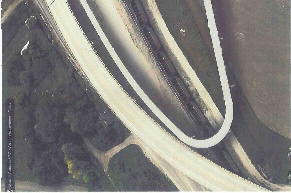
6 Attachment A Page 4 of 10 Allentlon: Ed Chanter, Director of Lands Flle ~ Date: February 13, 2014 Page: 2 of 4 systems port. The combination of increased recreational use plus increased truck and train traffic results in a higher opportunity for conflicts and exacerbates the concern over the safe use of the dyke trail across the Deltaport Way corridor. Although 41 b Street is the designated cycling route Intended to divert cyclists away from Deltaport Way and the rail corridor, this diversion is not a practical solution and we understand that cyclists and pedestrians continue to make unsafe crossings of the roadway and tracks. Furthermore, the recreational potential of the dyke system is not fully realized by this discontinuity. TFN possesses a vision to connect the local community via multi-use pathways that provide safe access to enjoyment of the lands in this area. Constructing a pedestrian bridge to grade separate the multi-use trail over Deltaport Way and the rail corridor will significantly improve the safety for recreational users and will result In a continuous recreational route that best utilizes the sea dyke and which is consistent with TFN's vision for a safe environment. Planned facilities are illustrated on the following plan ".:.'11'... ",...,:.-r... ""... ~~, ~...,..M,...,...,...,... ".."...,... A_1U1IOOUo/ """',A/.a (Gtcl110 C flrlftl :gijiwyd:rcl ~ I! "._xa"".-:iin.~. ~... _U-' nr. ~ I."""""' " _----'r~ WIoW4INI... '.,f t o' \ Nolr - _ ell Ioutn wui IIrIJflMd ~( 1OfJ oroty OT cew of U1 _wt~ihti(...- ~~OI ~_rorqe>go_r",,~r., en. u.. of t1w q<n Jr,......"" ~.. lj,tti"_,,. '"""'..,'.. "----, ~ I -... ""'rtf..,.... ~,..,,..,, 'NIt,...,.,-.."..., <;, ~ - "'....- JUt.,..,......,... '" r.t'.....,.. ' f' ,.... &Jc-~..."... "''''.", ,..... 'II 1 r 01 f fi \ r 1 - I 1 / _..." I s.,-.... I '= 1 flh III Is' I DlLTMOR' BCI(RR/U t ;lo V<Ct>I... "~...,.:sg,lhi.".". 'OQ / L _ ' fl!,it... F~'! ' Ī -!.. - Ir / -%F s JU~_J! I ~ ' 1:-.. ~8 I~m ~ I ~. ca.. IC». J... 1 /" v l B I Y 1... I /1 ' _D: II ~ I / I \... -!e"'" \:.-=r b. ~;. T~al'\ '.J5 en " / 8 I (] \, ID,.".. m',...,/ I L urbol1llystems co

, and 27B Avenue westbound (north of the structure).")


7 Attachment A Page 5 of 10 AUenllon: Ed Chantar, Director of Lands File: Dale: February 13, 2014 Page: 3014 systems Site Description The area where the dyke trail Intersects Deitaport Way Is congested by utility corridors (water and Be Hydro), the existing MoTI Roberts Bank Overhead (structure #2023), multiple rail lines entering the causeway, 27b Avenue eastbound (south of the structure), and 27B Avenue westbound (north of the structure). Each of these elements represents essential Infrastructure associated with the port and adjacent lands and n'eeds to be maintained. Concept Outline Safe crossing of cyclists and pedestrians across Deltaport Way and the adjacent rail lines could be accomplished by a grade separated facility, For the purpose of this brief we have collaborated with Structurecraft Limited to develop a conceptual arrangement for the pedestrian bridge and ramps. Structurecraft developed a high level concept for a pedestrian bridge that would cross all of the transportation infrastructure, however the estimated cost of this option was prohibitive. A new concept. ulban Yli lemsca


8 Attachment A Page 6 of 10 Attention: Ed Chenter, Director of Lands Flle: Dete: February 13, 2014 Page: 4 of 4 systems has been developed which crosses 27b Ave eastbound at grade and reduces the length of the east approach and the maximum height, thereby significantly reducing the total estimated cost. This alignment has the trail crossing 27b Ave eastbound at-grade and passing under the western end of the Deltaport Way bridge. The multiuse path ramps up at an approximate 6% grade parallel to and adjacent to the north side of the Deltaport Way structure. The pedestrian bridge swings over the 27b Ave westbound lanes and BC Rail tracks as soon as the required elevation is attained (5.5m clearance over the road and 1.01m clearance over the rail). The location of existing overhead high voltage hydro lines on the north side of the BCR tracks affects the alignment of the grade separation in as much as It is preferable to develop a bridge geometry which avoids the costs associated with relocating these lines. The overhead hydro constrains the ramp on the north side of the structure and the preferred alignment provides the grade length needed to obtain the required clearance under the lines. The area Is recognized to have soft compressible solis and high groundwater tables and as such the design of the foundations for the proposed pedestrian overpass structure will need to account for the nature of the ground conditions..1 Jl i' The anticipated order of magnitude cost for a structure of this type is in the range of $4M, exclusive of GST. In conclusion, the benefits of the Deltaport Way overpass include: Elimination of existing safety hazard for pedestrians and cyclists crossing BCR trackage Addresses future increased exposure and degraded safety conditions expected with the planned increase in truck and train traffic servicing the port facility Meets the future needs of Increased trail use anticipated from TFN land development Continuous local seaside GBHW trail connection through TFN lands Contribution to completion of Experience the Fraser between Tsawwassen Ferry Terminal and Hope We trust the foregoing is satisfactory for discussion purposes. Sincerely, URBAN SYSTEMS LTD. ~~ Sr Transportation Engineer cc: Tom McCarthy, CAD, TFN Gerald Epp, Structurecraft /grs lllbansys!litns CD


9 . -' i I

10


11 Attachment A age 9 of10
01-'")

12 i! c: Q).2 0)01-' -0 ro u o
2. THAT the Mayor and Corporate Officer be authorized to execute all documents related to this matter.
 COUNCIL REPORT Report No. PRC 016-2016 EXECUTIVE COMMITTEE Date: March 2, 2016 File No: 6240-01 To: From: Subject: Mayor and Council Heidi Enns, General Manager, Parks, Recreation and Culture BikeBC Program
The Corporation of Delta COUNCIL REPORT Regular Meeting. BNSF Railway Company North Colebrook Siding
 The Corporation of Delta COUNCIL REPORT Regular Meeting.01 To: Mayor and Council From: Engineering Department File No.: 13480-02/BNSF Date: December 18,2013 BNSF Railway Company North Colebrook Siding
Pattullo Bridge Replacement Project Community Connections Phase 2 Consultation. Appendix 3: Open House Display Boards
 Replacement Project Community Connections Phase 2 Consultation Appendix 3: Open House Display Boards November 2016 Welcome! Welcome to the Replacement Project Public Open House We Want to Hear from You
Corporate. Report COUNCIL DATE: June 26, 2006 NO: C012 COUNCIL-IN-COMMITTEE. TO: Mayor & Council DATE: June 22, 2006
 Corporate NO: C012 Report COUNCIL DATE: June 26, 2006 COUNCIL-IN-COMMITTEE TO: Mayor & Council DATE: June 22, 2006 FROM: General Manager, Engineering FILE: 0410-20(MoT/Gate) SUBJECT: Surrey Response on
Date: February 18, 2015 Page: 1 of 9. ICBC invests $1.195 million to improve Surrey, Delta & White Rock roads
 News release Date: February 18, 2015 Page: 1 of 9 Media contacts: Lindsay Olsen, 604-982-4759 ICBC invests $1.195 million to improve Surrey, Delta & White Rock roads You may have noticed the new pedestrian
REPORT CONCURRENCE. City Manager. The General Manager concurs with the recommendation of this report.
 COUNCIL REPORT Report No. ENG 08-018 Executive Committee Date: May 0, 018 File No: 5400-1 To: From: Subject: Mayor and Council Purvez Irani, Senior Transportation Engineer Bluejay Street Road Improvements
1. What is the Doran Street and Broadway/Brazil Grade Separation Project (Project)?
?") 1. What is the Doran Street and Broadway/Brazil Grade Separation Project (Project)? The Los Angeles County Metropolitan Transportation Authority (Metro) is evaluating the development of a grade separation
1. What is the Doran Street and Broadway/Brazil Grade Separation Project (Project)? The Los Angeles County Metropolitan Transportation Authority (Metro) is evaluating the development of a grade separation
Improving Cyclist Safety at the Dundas Street West and Sterling Road Intersection
 STAFF REPORT ACTION REQUIRED Improving Cyclist Safety at the Dundas Street West and Sterling Road Intersection Date: August 17, 2012 To: From: Wards: Reference Number: Public Works and Infrastructure Committee
Basalt Creek Transportation Refinement Plan Recommendations
 Basalt Creek Transportation Refinement Plan Recommendations Introduction The Basalt Creek transportation planning effort analyzed future transportation conditions and evaluated alternative strategies for
Figure 1: East West Connector Alignment Alternatives Concept Drawing
 Page 2 of 9 Figure 1: East West Connector Alignment Alternatives Concept Drawing The Montebello Drive extension will run north south and connect Wilsonville Road to the Boones Ferry Road to Brown Road
Update from Port Metro Vancouver Deltaport Third Berth Project Community Liaison Group. Meeting Date: August 28, Construction Update
 Update from Port Metro Vancouver Deltaport Third Berth Project Community Liaison Group Meeting Date: August 28, 2008 Construction Update General Update The Marine Works portion of the project is progressing
North Vancouver Community Associations Network. November 15, pm to 9 pm
 North Vancouver Community Associations Network November 15, 2017 7 pm to 9 pm Topics Decision-making processes and constraints What is TransLink? What financial and planning requirements does TransLink
Trans-Canada Highway 1 RW Bruhn Bridge Replacement
 Trans-Canada Highway 1 RW Bruhn Bridge Replacement May 2016 RW Bruhn Bridge Project Objectives Improve safety, traffic flow and movement of goods Improve safety for pedestrians and cyclists Replace the
Highway 1 Kamloops to Alberta Four-Laning Program
 Highway 1 Kamloops to Alberta Four-Laning Program COMMUNITY ENGAGEMENT DISCUSSION GUIDE AND FEEDBACK FORM February 7 March 1, 2013 www.bchwy1.ca 1 FEEDBACK FORM INSIDE HOW INPUT WILL BE CONSIDERED FAST
CITY OF COCOA BEACH 2025 COMPREHENSIVE PLAN. Section VIII Mobility Element Goals, Objectives, and Policies
 CITY OF COCOA BEACH 2025 COMPREHENSIVE PLAN Section VIII Mobility Element Goals, Objectives, and Policies Adopted August 6, 2015 by Ordinance No. 1591 VIII MOBILITY ELEMENT Table of Contents Page Number
University of Victoria Campus Cycling Plan Terms of Reference. 1.0 Project Description
 University of Victoria Campus Cycling Plan Terms of Reference 1.0 Project Description The Campus Cycling Plan, a first for the University, will provide a comprehensive and coordinated approach to support
Chapter 7. Transportation. Transportation Road Network Plan Transit Cyclists Pedestrians Multi-Use and Equestrian Trails
 Chapter 7 Transportation Transportation Road Network Plan Transit Cyclists Pedestrians Multi-Use and Equestrian Trails 7.1 TRANSPORTATION BACKGROUND The District of Maple Ridge faces a number of unique
19 July 2016 OUR REF:
 19 July 2016 OUR REF: 602263-01000 194168 Ontario Ltd. 320 McRae Street Ottawa, ON K1Z 5R8 Attention: Brian Casagrande Dear Brian: Re: 320 McRae/1976 Scott Redevelopment CTS Addendum #1 This Addendum has
102 Avenue Corridor Review
 February 26, 2015 102 Avenue Corridor Review Transportation Association of Canada Road Safety Engineering Award Submission for the City of Edmonton Introduction Transportation Association of Canada Road
Non-Motorized Overpass at SR 5/US1
 Non-Motorized Overpass at SR 5/US1 And SR 97/SW th Street (Bird Road) Executive Summary March 9, 17 Prepared By: MARLIN Engineering Inc 17 NW th Avenue, Ste. 1 Plantation, FL 33313 P: 35.77.7575 www.marlinengineering.com
Viaducts, Eastern Core and False Creek Flats Cycling Improvements HUB Vancouver/UBC committee 2013/05/13
 Viaducts, Eastern Core and False Creek Flats Cycling Improvements HUB Vancouver/UBC committee 2013/05/13 Table of Contents Executive Summary Cycling in the Viaducts Area: Current Situation and the City
George Massey Tunnel Replacement Project
 George Massey Tunnel Replacement Project Project Update Corporation of Delta Council January 9, 2017 Existing Challenges Collisions Impacts on: Congestion People Unreliability Goods Seismic vulnerability
Design of Stanley Park S-Curve
 ADMINISTRATIVE REPORT Date: May 4, 2001 TO: FROM: Author/Local: F. Klotzbach/7118 RTS NO. 01644 CC File No. Standing Committee on Transportation and Traffic General Manager of Engineering Services, in
ECONOMY PEOPLE ENVIRONMENT
 Report Back on Local Transit Improvements May 29, 2013 ECONOMY PEOPLE ENVIRONMENT Intro Council Requested Report Back Topics Progress on Planning for Broadway Subway False Creek Bridges Local Transit Improvements
ICBC invests $738,000 to make Surrey, White Rock and Delta roads safer
 For release: Immediately Page: 1 of 5 Date: April 2, 2012 Ref #: 2012-11 Media contacts: Karon Trenaman, 604-527-8766 ICBC invests $738,000 to make Surrey, White Rock and Delta roads safer You ve likely
ICBC invests $1.175 million to help make Surrey, Delta and White Rock s roads safer in 2013
 Date: March 18, 2014 Page: 1 of 8 Media contacts: Michelle Hargrave, 250-979-4642 Lindsay Olsen, 604-982-4759 ICBC invests $1.175 million to help make Surrey, Delta and White Rock s roads safer in 2013
Low Level Road Improvements Traffic Analysis. Report
 Low Level Road Improvements Traffic Analysis Report June, 22 Table of Contents. INTRODUCTION.... LOW LEVEL ROAD PROJECT....2 STUDY AREA....2. West-End Corridor Improvements... 2.2.2 East-End Corridor Improvements...
122 Avenue: 107 Street to Fort Road
 : 107 Street to Fort Road November 24, 2015 4:30 8:00 p.m. Meeting Purpose Summarize project work completed to date Share results of public input from Phase 1 Share the draft concept plan and proposed
STUDY PROCESS & SCHEDULE
 STUDY PROCESS & SCHEDULE Route Centennial Bridge Study KDOT Project No. -52 KA-3229-01 STUDY OVERVIEW STUDY SCHEDULE The Kansas Department of Transportation (KDOT) has identified a future need to replace
Duwamish Way-finding and CTR Report
 V. North Tukwila When the North Tukwila Manufacturing and Industrial Center was designated in 1992 as part of the region s land use and transportation plan, the plan called for the area to set a light-rail
TRANSPORTATION & MOBILITY
 TRANSPORTATION & MOBILITY ROADWAY SYSTEM There are approximately 40 miles of roadways in Manitou Springs. For planning purposes, roadways are typically assigned a functional classification which defines
Welcome to the McKenzie Interchange Project Open House!
 Welcome to the McKenzie Interchange Project Open House! Purpose of Open House To provide you with information regarding the project and for you to have the opportunity to share your input on design concepts.
Tonight is for you. Learn everything you can. Share all your ideas.
 Strathcona Neighbourhood Renewal Draft Concept Design Tonight is for you. Learn everything you can. Share all your ideas. What is Neighbourhood Renewal? Creating a design with you for your neighbourhood.
McKenzie Interchange Project Spring 2016 Comment Period. Appendix 1: Display Boards and Feedback Form
 McKenzie Interchange Project Spring 2016 Comment Period Appendix 1: Display Boards and Feedback Form August 2016 Welcome to the McKenzie Interchange Project Information Session! Purpose of this Information
Transportation Corridor Studies: Summary of Recommendations
 Transportation Corridor Studies: Summary of Recommendations Route 4 Corridor Study: Route 10 Corridor Study: Route 44 Corridor Study: Route 175 Corridor Study: Route 5/15 Corridor Study: Rentschler Field
City of Moorhead Committee of the Whole Meeting
 City of Moorhead Committee of the Whole Meeting Corridor Study Limits Center Avenue (Red River to 8th Street) TH 10 (Red River to TH 336) TH 75 (20th Ave S to Main Avenue) 2 Study Need: Project Overview
4. ENVIRONMENTAL IMPACT ANALYSIS 9. TRANSPORTATION AND TRAFFIC
 4. ENVIRONMENTAL IMPACT ANALYSIS 9. TRANSPORTATION AND TRAFFIC 4.9.1 INTRODUCTION The following section addresses the Proposed Project s impact on transportation and traffic based on the Traffic Study
CITY OF SPOKANE VALLEY Request for Council Action
 CITY OF SPOKANE VALLEY Request for Council Action Meeting Date: December 16, 2014 Department Director Approval: Check all that apply: consent old business new business public hearing information admin.
Scarlett Road Bridge & Road Improvements Lambton Park Community School - Gymnasium Tuesday November 28 th, 2017
 Scarlett Road Bridge & Road Improvements Lambton Park Community School - Gymnasium Tuesday November 28 th, 2017 PROJECT LOCATION 2 SCARLETT ROAD BRIDGE Constructed in 1912, the bridge carries 4 active
CHIEF PEGUIS TRAIL EXTENSION WEST
 1 PRELIMINARY DESIGN OF THE CHIEF PEGUIS TRAIL EXTENSION WEST Public Information Session June 6, 2017 Welcome 1 Thank you for attending today s public information session. The following boards provide
FY STATEWIDE TRANSPORTATION IMPROVEMENT PROGRAM New Jersey Department of Transportation Projects
 ROUTE/ Project ID No. TIP No. Electrical Load Center Replacement - North 04324 04324 This project will provide for the betterment of the existing highway lighting facilities located along Routes 3, 17
TRANSPORTATION NEEDS ASSESSMENT
 TRANSPORTATION NEEDS ASSESSMENT A travel demand analysis was carried out to determine the operational issues and the potential benefit that adding traffic capacity would have on the road network. All the
Southwest Bus Rapid Transit (SW BRT) Functional Planning Study - Executive Summary January 19 LPT ATTACHMENT 2.
 Functional Planning Study - Executive Summary January 19 LPT ATTACHMENT 2.") Southwest Bus Rapid Transit (SW BRT) Functional Planning Study - Executive Summary 2011 January 19 1 of 19 Introduction This executive summary presents the results of the Southwest Bus Rapid Transit (SW
Southwest Bus Rapid Transit (SW BRT) Functional Planning Study - Executive Summary 2011 January 19 1 of 19 Introduction This executive summary presents the results of the Southwest Bus Rapid Transit (SW
THE CORPORATION OF THE DISTRICT OF CENTRAL SAANICH. COMMITTEES - 7:00 PM Monday, April 27, 2015 Council Chambers AGENDA
 THE CORPORATION OF THE DISTRICT OF CENTRAL SAANICH COMMITTEES - 7:00 PM Monday, April 27, 2015 Council Chambers AGENDA 1. CALL TO ORDER 2. ADOPTION OF AGENDA 3. ADOPTION OF MINUTES 4. PRESENTATIONS AND
QUICKIE C STORE AND GAS BAR 1780 HERON ROAD OTTAWA, ONTARIO TRANSPORTATION BRIEF. Prepared for:
 QUICKIE C STORE AND GAS BAR 1780 HERON ROAD OTTAWA, ONTARIO TRANSPORTATION BRIEF Prepared for: Quickie Convenience Stores Larny Holdings Ltd. c/o PBC Group April 15, 2015 115-615 Report_1.doc D. J. Halpenny
I-20 ODESSA-MIDLAND CORRIDOR STUDY. Public Meeting for Schematic Design
 I-20 ODESSA-MIDLAND CORRIDOR STUDY Public Meeting for Schematic Design The environmental review, consultation, and other actions required by applicable Federal environmental laws for this project are being,
Route 7 Corridor Study
 Route 7 Corridor Study Executive Summary Study Area The following report analyzes a segment of the Virginia State Route 7 corridor. The corridor study area, spanning over 5 miles in length, is a multi
Wyldewood Estates. Pre-Application Public Engagement Summary of Issues and Responses
 Wyldewood Estates Pre-Application Public Engagement Summary of Issues and Responses March 2016 Executive Summary Morguard Residential Properties has been thoughtfully planning the redevelopment of Wyldewood
Toronto and East York Community Council. Director, Transportation Services, Toronto and East York District
 No Turn on Red Regulations STAFF REPORT ACTION REQUIRED Date: June 1, 2010 To: From: Toronto and East York Community Council Director, Transportation Services, Toronto and East York District Wards: Trinity
I-10 Bypass Project Banning to Cabazon
 I-10 Bypass Project Banning to Cabazon Presentation to City of Banning Town Hall Meeting April 11, 2018 June 17 th, 2005 Emergency Action Plan Conceptual Project Purpose Summary Construct a new roadway
Los Altos Hills Town Council - June 18, 2015 Palo Alto City Council June 22, AGENDA ITEM #2.B Presentation
 Los Altos Hills Town Council - June 18, 2015 Palo Alto City Council June 22, 2015 AGENDA ITEM #2.B Presentation Previous Presentations Los Altos Hills Town Council in May 2014 and February 2015 Palo Alto
Washington DC Section of ITE Project Briefing
 Washington DC Section of ITE Project Briefing November 5, 2015 Renée Hamilton, VDOT, Deputy District Administrator I-66 Outside the Beltway Improvement Area Project Location Virginia 2 Purpose and Need
YELLOWHEAD TRAIL / 149 STREET INTERCHANGE
 YELLOWHEAD TRAIL / 149 STREET INTERCHANGE WELCOME Today we are introducing the concept planning project for a new gradeseparated interchange at Yellowhead Trail and 149 Street PURPOSE Provide information
McKenzie Interchange Project Fall 2015 Engagement. Appendix 2: Engagement Materials and Feedback Form
 Fall 2015 Engagement Appendix 2: Engagement Materials and Feedback Form Welcome to the McKenzie Interchange Project Open House! Purpose of Open House To provide you with information regarding the project
Project Description Form 6V
 Project Description Form 6V Basic Project Information Submitting Jurisdiction/Agency: Prince William County Project Title: Route 15 Widening: Route 55 to south of RR tracks & Construct RR Overpass Project
Draft North Industrial Area-Wide Traffic Plan
 Summary of North Industrial and Hudson Bay Industrial Recommended Improvements Table 1. Summary of s Item Location 1 2 3 4 5 6 7 8 9 10 11 12 Millar Ave north of 51st St Super 8 Motel back lane 400 Block
FEDERAL HIGHWAY ADMINISTRATION APPLICATION
 FEDERAL HIGHWAY ADMINISTRATION APPLICATION REQUEST FOR PERMISSION TO EXPERIMENT WITH A BICYCLE BOX INTERSECTION TREATMENT Submitted by: City of Columbus Department of Public Service Date: June 26, 2009
5 REQUEST FOR GRADE-SEPARATED PEDESTRIAN UNDERPASS CROSSINGS OF LESLIE STREET AND ST. JOHN S SIDEROAD TOWN OF AURORA
 5 REQUEST FOR GRADE-SEPARATED PEDESTRIAN UNDERPASS CROSSINGS OF LESLIE STREET AND ST. JOHN S SIDEROAD TOWN OF AURORA The Transportation Services Committee recommends the adoption of the recommendations
Terwillegar Drive Expressway Draft Concept Plan
 Terwillegar Drive Expressway Draft Concept Plan Anthony Henday Drive to Whitemud Drive November 28 5:00-8:00 p.m. December 1 10:00 a.m. - 3:00 p.m. Let s Talk Today you can: Learn about the new direction
Dear Mayor Murray, Top SR-520 Design Innovations and Remaining Opportunities
 Dear Mayor Murray, Thank you for your leadership building a transportation system that moves people efficiently throughout the region, and creates healthy places to live, work, and play. We are glad you
APPENDIX H EXISTING TRAFFIC CONDITIONS ANALYSIS
 APPENDIX H EXISTING TRAFFIC CONDITIONS ANALYSIS MEMO : Peter Steacy, P.Eng. Date: December 3, 2014 : Ian Borsuk, P.Eng. Job No.: 3414015-000 Subject: City of Ottawa O-Train Extension Planning & EA Study
Sixth Line Development - Transit Facilities Plan
 Memorandum Date: November 13, 2012 To: From: c.c. Subject: Rob Freeman (Freeman Planning) Kevin Phillips Sixth Line Development - Transit Facilities Plan 33016631 This memo was prepared to review the transit
Clackamas County Comprehensive Plan
 ROADWAYS The County s road system permits the movement of goods and people between communities and regions, using any of a variety of modes of travel. Roads provide access to virtually all property. They
Welcome 78 Ave S.E. Underpass and Road Widening Project Update
 Welcome 78 Ave S.E. Underpass and Road Widening Project Update About the 78 Avenue S.E. Project 69 Avenue S.E. crossing of CP proposed to close to accommodate future CP operations. 78 Avenue S.E. would
TO: FROM: SUBJECT: RECOMMENDATION
 February 8, 2018 TO: Park Board Chair and Commissioners FROM: General Manager Vancouver Board of Parks and Recreation SUBJECT: United 2026 Bid (FIFA) Training Site Agreement RECOMMENDATION A. THAT the
Governance and Priorities Committee Report For the July 2, 2015 Meeting
 CITY OF VICTORIA For the July 2, 2015 Meeting To: Governance and Priorities Committee Date: From: Subject: Brad Dellebuur, A/Assistant Director, Transportation and Parking Services Executive Summary The
APPENDIX 2 LAKESHORE ROAD TRANSPORTATION REVIEW STUDY EXECUTIVE SUMMARY
 APPENDIX 2 LAKESHORE ROAD TRANSPORTATION REVIEW STUDY EXECUTIVE SUMMARY Appendix 2 City of Mississauga Lakeshore Road FINAL REPORT Transportation Review Study December 2010 EXECUTIVE SUMMARY Study Purpose
5. MODIFICATIONS AT JEANNE D ARC BOULEVARD/REGIONAL ROAD 174 INTERCHANGE INTERSECTION - PUBLIC HEARING COMMITTEE RECOMMENDATION
 5. MODIFICATIONS AT JEANNE D ARC BOULEVARD/REGIONAL ROAD 174 INTERCHANGE INTERSECTION - PUBLIC HEARING COMMITTEE RECOMMENDATION Having held a public hearing, that Council approve the preliminary designs
WELCOME TO OPEN HOUSE # 1 June 14, 2017
 Langstaff Road Weston Road to Highway 7 Class Environmental Assessment Study WELCOME TO OPEN HOUSE # 1 June 14, 2017 Please sign in and join our mailing list Purpose of Open House #1 & Study Area York
Roundabouts in Edmonton - A Comparison to the State-of-the-Art
 Roundabouts in Edmonton - A Comparison to the State-of-the-Art Authors: Carl Clayton, P.Eng. P.E. PTOE Stantec Consulting Ltd. Chuan Kua, P.Eng. City of Edmonton, Transportation and Streets Brice Stephenson,
Welcome to the Open House
 Leslie Street Between 19 th Avenue and Stouffville Road Addendum to Class Environmental Assessment Study Welcome to the Open House Please sign in at the front desk. March 28, 2017 Richmond Green Sports
DRAFT BUENA VISTA 2020 TRANSPORTATION PLAN
 DRAFT BUENA VISTA 2020 TRANSPORTATION PLAN DEVELOPED BY THE TRANSPORTATION PLANNING DIVISION OF THE VIRGINIA DEPARTMENT OF TRANSPORTATION IN COOPERATION WITH THE U.S. DEPARTMENT OF TRANSPORTATION, FEDERAL
Sustainable Mobility in Greater Sudbury NeORA Conference September 25, 2012
 Sustainable Mobility in Greater Sudbury NeORA Conference September 25, 2012 Presented by: David Shelsted, MBA, P.Eng., Director of Roads & Transportation Services The City s Transportation Network Approximately
Lee s Summit Road Improvement Study Public Open House June 7, 2007 Summary of Comment Card Responses
 Lee s Summit Road Improvement Study Public Open House June 7, 2007 Summary of Comment Card Responses Introduction At the Lee s Summit Road Improvement Study Public Open House held Thursday, June 7, 2007
Blair/Williamson Intersection Expressed Needs
 Blair/Williamson Intersection Expressed Needs NORTH Blair Street is a barrier for pedestrians and bicycles Relocate Capitol City Trail crossing from Blair Street and John Nolen Drive intersection to Williamson
MEETING FACILITY 2901 GIBFORD DRIVE CITY OF OTTAWA TRANSPORTATION BRIEF. Prepared for: Holiday Inn Express 2881 Gibford Drive Ottawa, ON K1V 2L9
 MEETING FACILITY 2901 GIBFORD DRIVE CITY OF OTTAWA TRANSPORTATION BRIEF Prepared for: Holiday Inn Express 2881 Gibford Drive Ottawa, ON K1V 2L9 December 18, 2012 112-566 Brief_1.doc D. J. Halpenny & Associates
CITY OF SEATTLE RESOLUTION. WHEREAS, the Washington State Department of Transportation (WSDOT) led the Seattle
 led the Seattle") SDOT SR0 Design Refinements RES August, 0 Version #D 0 CITY OF SEATTLE RESOLUTION..title A RESOLUTION relating to the State Route 0, Interstate to Medina Bridge Replacement and High Occupancy Vehicle Project;
SDOT SR0 Design Refinements RES August, 0 Version #D 0 CITY OF SEATTLE RESOLUTION..title A RESOLUTION relating to the State Route 0, Interstate to Medina Bridge Replacement and High Occupancy Vehicle Project;
Access Routes from US 101 to the Richmond San Rafael Bridge
 Access Routes from US 101 to the Richmond San Rafael Bridge TAM Board Meeting January 28, 2016 RSRB Project Elements Eastbound Third Lane: Sir Francis Drake Blvd. to Marine Street 10 ft Barrier Separated
5. WOODROFFE AVENUE BUS-ONLY LANES BASELINE STATION TO FALLOWFIELD PARK & RIDE CONSULTANT APPOINTMENTS CONTRACTS NOS. ETL , 6001 AND 6002
 5. WOODROFFE AVENUE BUS-ONLY LANES BASELINE STATION TO FALLOWFIELD PARK & RIDE CONSULTANT APPOINTMENTS CONTRACTS NOS. ETL 99-6000, 6001 AND 6002 COMMITTEE RECOMMENDATIONS That Council approve: 1. The award
Nanaimo Transportation Master Plan. Phase 1 Consultation Summary
 Nanaimo Transportation Master Plan Phase 1 Consultation Summary Transportation Advisory Committee Meeting Wednesday December 12, 2012 Agenda Study Update Phase 1 Consultation Process Phase 1 Consultation
OFFICE/RETAIL DEVELOPMENT 1625 BANK STREET OTTAWA, ONTARIO TRANSPORTATION BRIEF. Prepared for: Canada Inc.
 OFFICE/RETAIL DEVELOPMENT 1625 BANK STREET OTTAWA, ONTARIO TRANSPORTATION BRIEF Prepared for: 9402209 Canada Inc. December 15, 2015 115-625 Report_2.doc D. J. Halpenny & Associates Ltd. Consulting Transportation
Zlatko Krstulich, P.Eng. City of O9awa
 Zlatko Krstulich, P.Eng. City of O9awa 1. Introduction to the Ontario Traffic Manual Series 2. What is OTM Book 18: Bicycle Facilities? 3. Study / Committee Team Members 4. Brief overview of the content
Proposed Bridge Street East Bicycle Lanes Public Open House Thursday, April 27, 2017
 WELCOME Proposed Bridge Street East Bicycle Lanes Public Open House Thursday, April 27, 2017 Purpose of the Open House The purpose of this Open House is to gain public input on the bicycle lanes proposed
I-395 Express Lanes Northern Extension Project Public Hearings
 I-395 Express Lanes Northern Extension Project Public Hearings Susan Shaw, PE, Megaprojects Director Virginia Department of Transportation Amanda Baxter, Special Projects Manager Virginia Department of
City of Gainesville Transportation/Roadway Needs PROJECT SUMMARY
 A1 Roadway Resurfacing $23,846,000 TYPE: Preservation of existing system Roadway resurfacing A2 Signal Replacement $6,000,000 TYPE: Preservation of existing system Replace traffic signals. B1 W 6th St
COUNTY ROAD 22 HORSESHOE VALLEY ROAD. Municipal Class Environmental Assessment. simcoe.ca
 OCTOBER 2014 Municipal Class Environmental Assessment COUNTY ROAD 22 HORSESHOE VALLEY ROAD Project A Truck Climbing Lanes Project B Intersection Improvements simcoe.ca CORPORATE COMMUNICATIONS DEPARTMENT
Guildwood Village Traffic Response Prepared by City of Toronto Transportation Department
 Guildwood Village Traffic Response Prepared by City of Toronto Transportation Department 1. Traffic Impacts Associated With Improvements to the Lake Shore East GO Transit Rail Corridor Proposed by Metrolinx
CITY OF VAUGHAN EXTRACT FROM COUNCIL MEETING MINUTES OF OCTOBER 30, 2012
 CITY OF VAUGHAN EXTRACT FROM COUNCIL MEETING MINUTES OF OCTOBER 30, 2012 Item 31, Report No. 39, of the Committee of the Whole, which was adopted without amendment by the Council of the City of Vaughan
Community Task Force March 14, 2018
 Community Task Force March 14, 2018 Welcome and Introductions Project Partners Regional Transportation District (RTD) City of Aurora Colorado Department of Transportation (CDOT) Denver Regional Council
Anniedale - Tynehead NCP. Transportation Highway 15 & Golden Ears Way Analysis
 Highway 15 & Golden Ears Way Analysis Stage 1 Conclusions Analysis indicated capacity constraints at Highway 15 & Golden Ears Way Grade Separation required for safe and efficient traffic movement Supports
W Seattle Bridge / Duwamish Corridor
 W Seattle Bridge / Duwamish Corridor IDT and Action Report City Council Transportation Committee Mark Bandy, Bill LaBorde, Chisaki Muraki-Valdovinos September 22, 2015 Our mission, vision, and core values
2. NORTEL CARLING CAMPUS EXPANSION - PROPOSED MODIFICATIONS TO MOODIE DRIVE (REGIONAL ROAD 59) AND HIGHWAY 417 INTERCHANGE
 AND HIGHWAY 417 INTERCHANGE") 2. NORTEL CARLING CAMPUS EXPANSION - PROPOSED MODIFICATIONS TO MOODIE DRIVE (REGIONAL ROAD 59) AND HIGHWAY 417 INTERCHANGE COMMITTEE RECOMMENDATIONS AS AMENDED That Council approve: 1. The endorsement
2. NORTEL CARLING CAMPUS EXPANSION - PROPOSED MODIFICATIONS TO MOODIE DRIVE (REGIONAL ROAD 59) AND HIGHWAY 417 INTERCHANGE COMMITTEE RECOMMENDATIONS AS AMENDED That Council approve: 1. The endorsement
Municipal Class EA To Address Traffic Congestion On The Ontario Street Corridor (Grand Bend) Public Information Meeting June 4, 2018
 Public Information Meeting June 4, 2018") Municipal Class EA To Address Traffic Congestion On The Ontario Street Corridor (Grand Bend) Public Information Meeting June 4, 2018 Background Agenda Traffic Study Update Class EA Alternatives Bridge
Municipal Class EA To Address Traffic Congestion On The Ontario Street Corridor (Grand Bend) Public Information Meeting June 4, 2018 Background Agenda Traffic Study Update Class EA Alternatives Bridge
Environmental Assessment Findings & Recommendations. Public Hearing November 13, 2014
 Environmental Assessment Findings & Recommendations Public Hearing November 13, 2014 Welcome! Welcome and Introductions Project and Environmental Assessment Overview Public Comments Adjourn Purpose of
Minor Amendments to the Street and Traffic By-law 2849 and Skateboards in Protected Bike Lanes
 ADMINISTRATIVE REPORT Report Date: October 31, 2017 Contact: Lon LaClaire Contact No.: 604.873.7336 RTS No.: 12241 VanRIMS No.: 08-2000-20 Meeting Date: November 15, 2017 TO: FROM: SUBJECT: Standing Committee
METHODOLOGY. Signalized Intersection Average Control Delay (sec/veh)
") Chapter 5 Traffic Analysis 5.1 SUMMARY US /West 6 th Street assumes a unique role in the Lawrence Douglas County transportation system. This principal arterial street currently conveys commuter traffic
Chapter 5 Traffic Analysis 5.1 SUMMARY US /West 6 th Street assumes a unique role in the Lawrence Douglas County transportation system. This principal arterial street currently conveys commuter traffic
TO: Board Members Vancouver Park Board FROM: General Manager Parks and Recreation SUBJECT: Seaside Greenway Improvements
 Date: October 1, 2013 TO: Board Members Vancouver Park Board FROM: General Manager Parks and Recreation SUBJECT: Seaside Greenway Improvements RECOMMENDATION A. THAT the Board approve the new bike paths
Transportation Master Plan Advisory Task Force
 Transportation Master Plan Advisory Task Force Network Alternatives & Phasing Strategy February 2016 BACKGROUND Table of Contents BACKGROUND Purpose & Introduction 2 Linking the TMP to Key Council Approved
Public Works and Infrastructure Committee. General Manager, Transportation Services
 STAFF REPORT ACTION REQUIRED Extending the Bay Street Bicycle Lanes Date: May 16, 2013 To: From: Public Works and Infrastructure Committee General Manager, Transportation Services Wards: Toronto Centre
Welcome. Thank you for your interest in the Lewis & Clark Viaduct Concept Study
 Welcome Thank you for your interest in the Lewis & Clark Viaduct Concept Study Please use the arrows in the upper left hand corner to navigate through the presentation. Use the envelope icon to ask a question