People Active in Community Effort Walkable Community Workshop Report May 1, 2008
|
|
|
- Louise Perkins
- 5 years ago
- Views:
Transcription
 has developed the Walkable Community Program (WCP).")

1 People Active in Community Effort Walkable Community Workshop Report May 1, 2008 In support of a balanced and inclusive transportation system, the San Antonio- Bexar County Metropolitan Planning Organization (MPO) has developed the Walkable Community Program (WCP). The program recognizes the need to plan for everyone and all modes of travel, whether young or old, motorist or bicyclist, walker or wheelchair user or bus rider. The WCP is modeled after a national program that encourages communities to design a comprehensive and coordinated system that is safe and more welcoming to pedestrians and cyclists. Goals of our local Walkable Community Program are to: 1) Educate residents and public officials on the advantages of embracing walking and bicycling as viable modes of transportation. 2) Help the community identify infrastructure improvements that encourage walking and cycling. 3) Serve as a communication forum between the community, the MPO s Transportation Policy Board and MPO partner transportation agencies. The People Active in Community Effort (PACE) Association participated in the process that included three meetings. The third meeting will be to present this report. MPO transportation partners represented at the workshops included Alamo Area Council of Governments, Bexar County, City of San Antonio, Texas Department of Transportation and VIA Metropolitan Transit. Having staff available from partner agencies increases the resources and encourages even greater participation. The workshops provide the opportunity for residents to meet and discuss issues that limit mobility within the community. The WCP is developed as an education process explaining the benefits of using alternative modes of travel such as bicycling, walking and transit. The MPO s Walkable Community Program contributes to planning for a safe, walkable and bikeable community.


, Southwest and Northside (NISD) Independent School Districts are represented within the boundaries.")
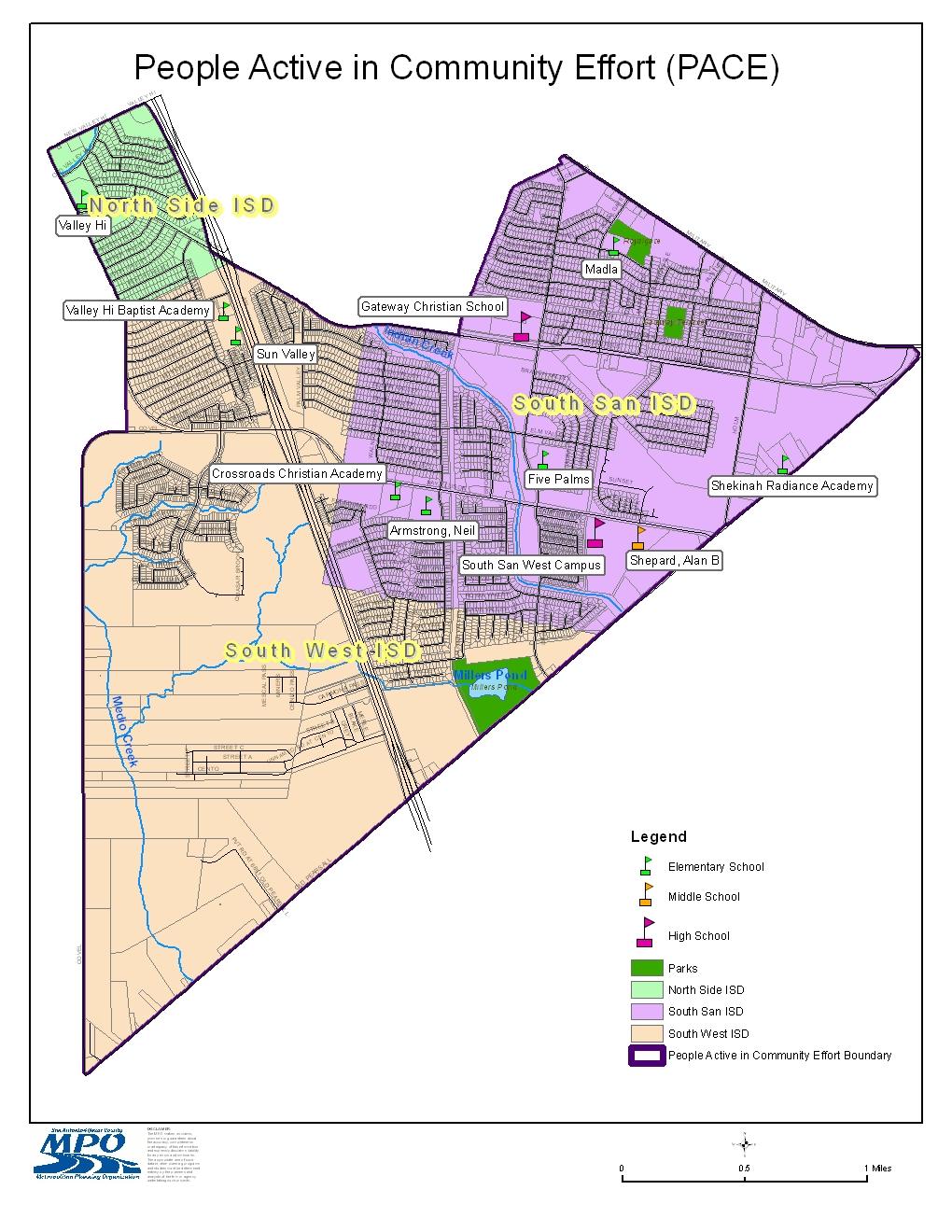
2 Study Area Description and Background Information The study area for the workshop includes the boundary of the PACE Neighborhood. PACE boundaries begin at the intersection of Loop 410 and Old Pearsall Road, then Northeast on Old Pearsall Road to its intersection with Military Drive West, then Northwest on Military Drive West to its intersection with Five Palms Drive, then following the boundary line of Lackland Air Force Base South to Medina Base Road, then continuing West along Medina Base Road to the East of Loop 410 access road, then North to its intersection with Valley Hi Drive to its intersection with Ray Ellison Drive, then South along Ray Ellison Drive to its intersection with Covel Road, then South along Covel Road to its intersection with Old Pearsall Road, including the Nelson Gardens Landfill and the Covel Gardens landfills, then along Old Pearsall Road to the point of beginning. South San Antonio (South San ISD), Southwest and Northside (NISD) Independent School Districts are represented within the boundaries. Schools from South San ISD include South San Antonio High School West, Alan B. Shepard Middle School, Five Palms Elementary School, Neil Armstrong Elementary School, and Frank Madla Elementary School. Schools from the NISD include Valley Hi Elementary School. The area is primarily residential, with single-family detached homes and some multifamily apartment complexes. There are a few small businesses (i.e. motels and restaurants) interspersed throughout the study area. VIA Metropolitan Transit service routes include 550/551-Looper skip, 611-Valley Hi/Kel-Lac, 614-Hidden Cove/Kel-Lac, 616-Sky Harbour/Kel-Lac, 619- Indian Creek/Kel-Lac. VIA s Kel-Lac Transit Center is in close proximity of the neighborhood s boundaries. Miller s Pond and adjoining park and community center are included within the boundary. There is quite a bit of undeveloped land within the boundary. From a planning standpoint there is opportunity in the PACE boundary to retrofit development using the Urban Design concepts. A Land Use and Zoning Map is included in the report for future planning purposes. The community is included in the larger San Antonio United Southwest Communities Plan through the City of San Antonio Planning and Community Development Department. This report could serve as an update for a portion of the larger plan if it is determined appropriate by all concerned.
3


4 Community Outreach Ms. Michelle Perales, President of PACE, submitted the application on behalf of the residents. Ms. Perales did extensive outreach to the residents, businesses in the area and schools in the area. There are two examples below of the written material. Ms. Perales, contacted residents and schools by , flyers, phone and in person to gather support for the workshop.
5 Walkable Community Workshop The first of three events was held on January 31, 2008 from 7:00 8:00 p.m., during the regularly scheduled PACE meeting at Knights of Columbus Hall located at 5763 Ray Ellison Boulevard. The hall is centrally located within the boundary. The neighborhood association provided refreshments. MPO staff provided a presentation explaining the importance of a transportation system that encourages walking, cycling and transit. Staff from Representative Leibowitz, Commissioner Rodriguez and Councilman Cortez offices attended the workshop and expressed support for the process and the potential outcomes. Councilman Cortez addressed the participants at the close of the meeting. Maps were presented for display and information. The participants were provided a Walkability Checklist and a Bikeability Checklist and asked to use the forms during the next month to prepare for the mapping exercise on February 28, The checklists give residents the opportunity to use the information discussed in the presentation in the community. On February 28, 2008, MPO staff and transportation partners returned for the mapping exercise. The success of the workshops is influenced greatly on the support of partner agencies. Agencies present at the mapping exercise included Alamo Area Council of Governments, Bexar County, City of San Antonio, VIA Metropolitan Transit and Texas Department of Transportation. Maps were presented for display and information as well as tools during the workshop. The mapping exercise began with a short review of the previous meeting. Then participants were asked to break out into four groups. Each group consisted of a map of the PACE boundary and two facilitators. Participants were asked to consider the Walkability and Bikeability Checklists provided at the previous meeting to help identify concerns in the community. There was a strong representation from the schools within the area at the February 28 th meeting. Each group reported their top five observations to the entire audience for improving the walkability of the community. Representatives from the staff of all elected officials were represented at this meeting. Representative Leibowitz addressed the participants at the close of the meeting. Participants at both workshops displayed a sincere desire to be involved with planning in their community. There was interest in planning that avoids urban sprawl and advocates compact, transit-oriented, walkable and bicycle-friendly land use. This type of planning preserves and enhances natural and cultural resources and promotes public health. Each table at the February 28 th meeting identified areas in the community they would like to see developed as green space and possible walking and biking trails.
6 The third meeting will be to present this report and has not been identified at this point. The MPO will contact Ms. Perales and request to be on a PACE regularly scheduled meeting to present the report. Comments by participants included topics not specific to transportation infrastructure. All topics are being included in the report based on the concept of a Walkable Community. Common discussion included the desire to have more green space in the community and better facilities for pedestrians. Table 1 List of Infrastructure Improvements Identified Area of Interest Identified Concern A. Road/Sidewalk 1. Ray Ellison Rd in bad repair between Loop 410 and Old Pearsall Road; drainage and flooding concern 2. Roadways not walking and bicycle friendly needing sidewalks along entire route include Ray Ellison Drive Five Palms Road Medina Base Road 3. Miller s Pond: Sidewalks leading to Miller s Pond requested 4. Sidewalk conditions in the North Pace and East Pace area are poor 5. Speed bumps needed at the 6100 block of Apple Valley Road
7 Road/Sidewalk (Continued) 6. Speeding occurring near entrance to Lackland AFB at Valley Hi Elementary 7. Need pedestrian crosswalk at Ray Ellison Drive and Apple Valley Road 8. Sidewalks requested at the 6100 block of Apple Valley Road B. VIA Metropolitan Transit 1. Transit stops in low traffic areas seem to always be vandalized Review transit stop locations; some stops are located where there are not homes/shops, etc 2. Consider alternatives to the large vehicles on the neighborhood streets. Residents are concerned with the noise and road maintenance associated with the large vehicles 3. Many of the transit stops have no amenities at all; consider including cement pads, benches, covers, etc for all stops C. Park/Recreation Amenities 1. Bicycling/Walking path incorporating the abandoned railway and drainage system linking the neighborhoods to Miller s Pond 2. Interest in more pocket parks within the PACE Boundary
8 Park/Recreation Amenities (continued) 3. Gateway Terrace was planned for a park and the project stopped; would like it reconsidered 4. Two swimming pools were in the geographic boundaries in the past; both have been closed. No local area for children or adults to swim without driving D. School Concerns 1. Planning in the community should focus on ways children can bicycle or walk easily to school throughout the area. 2. Crosswalks are needed at Shepherd Middle School and West Campus High School 3. School Zone signage is not placed correctly at Five Palms Elementary School 4. Five Palms Elementary School needs sidewalks on adjacent side of Five Palms Road 5. Safe bike parking at all schools in the area 6. Stray animals wandering near all school grounds E. Code Compliance Issues 1. Graffiti on houses and privacy fences abutting Loop 410 Access Road from Ray Ellison Drive to Old Valley Hi Drive
9 Code Compliance Issues (Continued) 2. Retention pond behind Apple Valley Road at the Lackland Heights subdivision needs brush removal and mowing 3. Front and Side Yard parking on 100 block of Rock Valley 4. Illegal dumping at Five Palms Road and Elm Valley Road 5. Illegal dumping at Elm Valley Road, near drainage channel 6. Illegal dumping along Medina Base Road from Loop 410 to Old Pearsall Road
10 Potential Funding Sources The third meeting is scheduled for March 26, 2009 to review the report and explain the next steps. There are no guaranteed funding sources for projects identified through the Walk able Community Program (WCP). Nonetheless, good planning has its own rewards in that the affected community begins working together with transportation agencies to identify and prioritize their transportation needs for cars, buses, walking and bicycling. This report represents the community speaking with one voice to assist elected officials and potential funding entities in seeking solutions to their transportation needs. Sharing project costs among several funding sources may be the best opportunity for funding above mentioned projects. Potential funding sources might include: Bexar County Special Road and Bridge Fund Farm to Market and Lateral Road Fund Future Capital Projects Bond Fund City of San Antonio Council Neighborhood Access Mobility Program Community Block Development Grant (CDBG) Program City Street Maintenance Program Advanced Transportation District (ATD) Program Future Capital Projects Bond Program San Antonio Bexar County Metropolitan Planning Organization Surface Transportation Program Metropolitan Mobility (after 2012) Texas Department of Transportation Statewide Transportation Enhancement Program District Discretionary Funds Category 2 Metropolitan Corridor Projects Safe Routes to School Funds Private Funding (examples) San Antonio Area Foundation The Meadows Foundation Robert Wood Johnson Foundation Local Private Companies
11 Next Steps Copies of this report are being provided to the Alamo Area Council of Governments, Bexar County Commissioner Precinct 1, City of San Antonio Council District 4, City of San Antonio Planning and Community Development, City of San Antonio Public Works, San Antonio-Bexar County MPO Transportation Policy Board, Texas Department of Transportation and VIA Metropolitan Transit. We encourage the PACE Neighborhood Association to consider the recommendations in this report in planning for funded projects in the future. The future is forever becoming the past. Planning for the future is a dynamic process. Planning for a healthy environment ensures a healthy community. The MPO supports the PACE Neighborhood Association in planning for the future. MPO Contact Information: Lydia Kelly Bicycle/Pedestrian Transportation Planner San Antonio Bexar County Metropolitan Planning Organization 825 S. St. Mary s St. San Antonio, TX Phone: Fax: kelly@sametroplan.org Website:
Greater Harmony Hills Neighborhood Association Walkable Community Workshop Report June 30, 2012
 Greater Harmony Hills Neighborhood Association Walkable Community Workshop Report June 30, 2012 In support of a balanced and inclusive transportation system, the San Antonio-Bexar County Metropolitan Planning
Corpus Christi Metropolitan Transportation Plan Fiscal Year Introduction:
 Introduction: The Safe, Accountable, Flexible, Efficient Transportation Equity Act: A Legacy for Users (SAFETEA-LU) has continued the efforts started through the Intermodal Surface Transportation Efficiency
5. Pedestrian System. Accomplishments Over the Past Five Years
 5. Pedestrian System Accomplishments Over the Past Five Years The Alamo Area Metropolitan Planning Organization (MPO) and its partner agencies recognize the importance of improving pedestrian mobility.
The Pedestrian Safety Action Plan
 The Pedestrian Safety Action Plan Lydia Kelly Bicycle Pedestrian Transportation Planner The San Antonio Bexar County MPO Planning Area and Partners Northeast Partnership Greater Bexar County Council of
MASTER BICYCLE AND PEDESTRIAN PLAN
 VILLAGE OF NORTHBROOK MASTER BICYCLE AND PEDESTRIAN PLAN DRAFT PLAN OPEN HOUSE May 2, 2018 AGENDA 1. Community Engagement 2. Vision and Goals 3. General Structure of Plan 4. Recommendations Overview 5.
Bicycle Master Plan Goals, Strategies, and Policies
 Bicycle Master Plan Goals, Strategies, and Policies Mobilizing 5 This chapter outlines the overarching goals, action statements, and action items Long Beach will take in order to achieve its vision of
Commerce Street Complete Street Project from Good Latimer Expressway to Exposition Avenue
 Commerce Street Complete Street Project from Good Latimer Expressway to Exposition Avenue T A N Y A B R O O K S A S S I S T A N T D I R E C T O R M O B I L I T Y P L A N N I N G M O B I L I T Y A N D S
RESOLUTION NO ?? A RESOLUTION OF THE CITY OF NEPTUNE BEACH ADOPTING A COMPLETE STREETS POLICY
 RESOLUTION NO. 2018-?? A RESOLUTION OF THE CITY OF NEPTUNE BEACH ADOPTING A COMPLETE STREETS POLICY WHEREAS, safe, convenient, and accessible transportation for all users is a priority of the City of Neptune
Living Streets Policy
 Living Streets Policy Introduction Living streets balance the needs of motorists, bicyclists, pedestrians and transit riders in ways that promote safety and convenience, enhance community identity, create
CONNECTING PEOPLE TO PLACES
 CONNECTING PEOPLE TO PLACES 82 EAST BENCH MASTER PLAN 07 Introduction The East Bench transportation system is a collection of slow moving, treelined residential streets and major arteries that are the
CITY OF BLOOMINGTON COMPLETE STREETS POLICY
 CITY OF BLOOMINGTON COMPLETE STREETS POLICY POLICY OBJECTIVE: The City of Bloomington will enhance safety, mobility, accessibility and convenience for transportation network users of all ages and abilities,
Proposed. City of Grand Junction Complete Streets Policy. Exhibit 10
 Proposed City of Grand Junction Complete Streets Policy Exhibit 10 1 City of Grand Junction Complete Streets Policy Vision: The Complete Streets Vision is to develop a safe, efficient, and reliable travel
A Complete Streets Policy for Saratoga Springs. Presented By: Shared Access Saratoga
 A Complete Streets Policy for Saratoga Springs Presented By: Shared Access Saratoga April 17, 2012 Agenda 1. Introduction to Complete Streets (CS) 2. Shared Access Saratoga 3. Why is CS Important 4. What
NM-POLICY 1: Improve service levels, participation, and options for non-motorized transportation modes throughout the County.
 Transportation PRINCE WILLIAM COUNTY 2008 COMPREHENSIVE PLAN NON-MOTORIZED PLAN CONTENTS Goals, Policies, and Action Strategies Table 4 (Bike Facility Classifications and Descriptions) Table 5 (Bike Facility
City of Novi Non-Motorized Master Plan 2011 Executive Summary
 City of Novi Non-Motorized Master Plan 2011 Executive Summary Prepared by: February 28, 2011 Why Plan? Encouraging healthy, active lifestyles through pathway and sidewalk connectivity has been a focus
Best Southwest Transportation Committee. North Central Texas Council of Governments Transportation Department
 Best Southwest Transportation Committee North Central Texas Council of Governments Transportation Department The The Regional Regional Veloweb Veloweb Review Review NCTCOG Bicycle and Pedestrian Program
Madison Urban Area and Dane County. Bicycle Transportation Plan Summary. September Introduction. Bicycle Plan Scope and Planning Process
 Bicycle Transportation Plan Summary Madison Urban Area and Dane County Introduction September 2000 Bicycling is an important mode of transportation in the Madison urban area and countywide that is available
Chapter 2. Bellingham Bicycle Master Plan Chapter 2: Policies and Actions
 Chapter 2 Bellingham Bicycle Master Plan Chapter 2: Policies and Actions Chapter 2: Policies and Actions The Bicycle Master Plan provides a road map for making bicycling in Bellingham a viable transportation
Tonight is for you. Learn everything you can. Share all your ideas.
 Strathcona Neighbourhood Renewal Draft Concept Design Tonight is for you. Learn everything you can. Share all your ideas. What is Neighbourhood Renewal? Creating a design with you for your neighbourhood.
Non-Motorized Transportation 7-1
 Non-Motorized Transportation 7-1 Transportation facilities no longer mean just accommodating a vehicle powered by a combustion engine. Pedestrian and non-motorized facilities are important modes of travel
NJDOT Complete Streets Checklist
 Background The New Jersey Department of Transportation s Complete Streets Policy promotes a comprehensive, integrated, connected multi-modal network by providing connections to bicycling and walking trip
Agenda. Overview PRINCE GEORGE S PLAZA METRO AREA PEDESTRIAN PLAN
 PRINCE GEORGE S PLAZA METRO AREA PEDESTRIAN PLAN May 28, 2008 Agenda Welcome and introductions Project overview and issue identification Planning context and strengths Design challenges and initial recommendations
BIKE PLAN CONTENTS GATEWAY
 CONTENTS Acknowledgments...vii Great Rivers Greenway District Board of Directors... vii Great Rivers Greenway District Staff... vii Project Consultants... vii Committees... viii Citizens Advisory Committee
SAFE ROUTES TO SCHOOL
 SAFE ROUTES TO SCHOOL Edgewood Elementary School Existing Conditions and ACTION PLAN > Oak Creek - Franklin Joint School District Table of Contents CONTEXT Enrollment Boundaries Enrollment
City of Charlottesville Bicycle and Pedestrian Master Plan Update
 City of Charlottesville Bicycle and Pedestrian Master Plan Update September 17, 2014 I. Welcome and meeting overview II. Project status update III. Network overview IV. Break-out groups Pedestrian Network
Vision: Traditional hamlet with an attractive business/pedestrian friendly main street connected to adjacent walkable neighborhoods
 N D. Focus Area II Vision: Traditional hamlet with an attractive business/pedestrian friendly main street connected to adjacent walkable neighborhoods Transit Road Focus Area II is located in the Hamlet
Table #6 VISION CHARACTERISTICS
 Table #6 VISION White Flint is a place to live, work, play, shop, and walk with sufficient density to encourage quality redevelopment. Vibrant streets and consistent streetscapes are important. CHARACTERISTICS
Appendix C 3. Bicycle / Pedestrian Planning
 Appendix C 3. Bicycle / Pedestrian Planning BICYCLE/PEDESTRIAN PLANNING 2005 Master Plan GOAL: Provide for safe and convenient bicycle and pedestrian circulation throughout the City. Develop a city-wide
APPENDIX A: Complete Streets Checklist DRAFT NOVEMBER 2016
 APPENDIX A: Complete Streets Checklist DRAFT NOVEMBER 2016 Complete Streets Checklist MetroPlan Orlando s Complete Streets Checklist is an internal planning tool for staff to further implementation of
Bicycle and Pedestrian Plans and Improvements
 Bicycle and Pedestrian Plans and Improvements Presented to the City Council By Randle Harwood, Planning and Development, and Richard Zavala, Parks and Community Services September 24, 2013 Purpose Review
Healthy Corridor Audit Tool
 Healthy Corridor Audit Tool How to Use:»» Complete the first section for the entire study area. Many indicators can be collected from existing data; they do not have to be collected on site.»» To assess
Richmond Connects Visioning Update
 Richmond Connects Visioning Update To date there have been four elements of the visioning process: Vision20 Night at Byrd Theatre on May 3rd Advisory Committee Meeting on May 12 th Public Visioning Workshop
Perryville TOD and Greenway Plan
 Perryville TOD and Greenway Plan Greenway Glossary Pathway: A bicycle and pedestrian path separated from motorized vehicular traffic by an open space, barrier or curb. Multi-use paths may be within the
Ocean Park Boulevard Green Street Project Alternatives & Trade Offs
 Planning Commission March 4, 2009 Ocean Park Boulevard Green Street Project Alternatives & Trade Offs Purpose of Tonight s Meeting Review concept plans and options Provide input on alternatives and trade-offs
EXECUTIVE SUMMARY. Vision
 Vision Walking and bicycling in Salt Lake City will be safe, convenient, comfortable, and viable transportation options that connect people to places, foster recreational and economic development opportunities,
WHAT CAN WE DO? SECTION 6
 WHAT CAN WE DO? SECTION 6 SATOMORROW MLTIMODAL TRANSPORTATION PLAN THE MLTIMODAL TRANSPORTATION PLAN What is a Multimodal Transportation Plan? The SA Tomorrow Multimodal Transportation Plan is the first
Chapter 5. Complete Streets and Walkable Communities.
 Chapter 5. Complete Streets and Walkable Communities. 5.1 Description of Complete Streets. Cities throughout the world, and specifically the United States, are coming to embrace a new transportation and
DRAFT. Table of Contents. Background
 Douglas County Table of Contents Existing Infrastructure 86 Funding 89 Policy and Program Recommendations 90 Infrastructure Recommendations 92 Conclusion 95 Background Home to 4,500 residents and Baker
Prince George s County plans, policies, and projects
 Prince George s County plans, policies, and projects Over 250 projects for trails, bikeways, designated bike lanes and sidewalk construction Trail projects that improve access to Metro Sidewalk and trail
Bicycle Pedestrian Master Plan Pre Bid Meeting Portsmouth, NH August 15, 2013
 Bicycle Pedestrian Master Plan Pre Bid Meeting Portsmouth, NH August 15, 2013 2005 Master Plan GOAL: Provide for safe and convenient bicycle and pedestrian circulation throughout the City. Develop a city
CITY MANUALS AND STANDARDS REVIEW
 GEORGETOWN SIDEWALK MASTER PLAN CITY MANUALS AND STANDARDS REVIEW RESOURCES AND STANDARDS As part of the Master Plan process, a review and evaluation of current City documents and policies relevant to
City of Davis East Covell Corridor Plan
 Community Open House #2 January 22, 2014 6:00 8:00 p.m. Veterans Memorial Center, Club Room City of Davis Introduction The (ECCP) is a taking a comprehensive look at the existing transportation systems
Sebastopol Charter School Traffic Management Plan
 Sebastopol Charter School The serves as the working document in support of these essential goals: to ensure the safety and efficiency of student arrival to and departure from school to ensure the safety
University of Victoria Campus Cycling Plan Terms of Reference. 1.0 Project Description
 University of Victoria Campus Cycling Plan Terms of Reference 1.0 Project Description The Campus Cycling Plan, a first for the University, will provide a comprehensive and coordinated approach to support
INDOT Complete Streets Guideline & Policy
 INDOT Complete Streets Guideline & Policy INTRODUCTION The Complete Streets guidelines build upon multiple efforts and promote a multimodal transportation system that is integrated and sustains land use
Pinellas County Safety Initiatives
 Florida Department of TRANSPORTATION Pinellas County Safety Initiatives Whit Blanton, FAICP Pinellas County MPO A Distinctive County A unique geography Multi-jurisdictional Key demographics seniors and
Bikeway action plan. Bicycle Friendly Community Workshop March 5, 2007 Rochester, MN
 Bikeway action plan Summary The was held on March 5, 2007 at the Rochester Mayo Civic Center. The workshop was hosted by Rochester-Olmsted County Planning Department in collaboration with the League of
Smart Growth Transportation Funding Forum April 9, 2015
 Smart Growth Transportation Funding Forum April 9, 2015 Please join the Coalition for Smart Growth, Lancaster General Health, and the Lancaster County Planning Commission in thanking our sponsors... Opening
Community Open House December 13, A project of the Green Infrastructure Center, supported by Skeo Solutions
 Community Open House December 13, 2011 A project of the Green Infrastructure Center, supported by Skeo Solutions Project Background The Green Infrastructure Center, Inc. (GIC) was formed in 2006 to help
City of Madison: 2017 Capital Budget Capital Improvement Plan
 Capital Improvement Plan Project Summary Bikeways Program 779,000 751,000 630,000 670,000 703,000 703,000 Cannonball Path 210,000 - - 730,000 - - Cap City Trail 1,140,000-360,000 - - 910,000 Ice Age Junction
The Florida Bicycle and Pedestrian Partnership Council
 The Florida Bicycle and Pedestrian Partnership Council Input to the Update of the Florida Transportation Plan March 2015 This document presents input from the Florida Bicycle and Pedestrian Advisory Council
FMATS Transportation Improvement Program Non-Motorized Project Nomination Form
 Project nominations are accepted from the public and are scored based on the adopted Project Scoring Criteria. These criteria assign weight based on the project s impact on the following: 1. Health and
S A F E R O U T E S T O S C H O O L H E R M A N TOW N S C H O O L S A N D P R O C TO R S C H O O L S P L A N A P P R OVA L S
 S A F E R O U T E S T O S C H O O L H E R M A N TOW N S C H O O L S A N D P R O C TO R S C H O O L S P L A N A P P R OVA L S WHAT IS SAFE ROUTES TO SCHOOL? In 1969, nearly 50% of children walked or rode
Bringing together community and health. Physical Activity and Nutrition Unit Office of Statewide Health Improvement Initiatives
 Bringing together community and health. Physical Activity and Nutrition Unit Office of Statewide Health Improvement Initiatives Physical Activity and Nutrition Unit Office of Statewide Health Improvement
ACTIVE TRANSPORTATION
 ACTIVE TRANSPORTATION Mobility 2040 Supported Goals Improve the availability of transportation options for people and goods. Support travel efficiency measures and system enhancements targeted at congestion
November 14, :00 p.m. Development & Planning Conference Room, 2nd Floor Village Hall AGENDA
 Village of Northbrook Bicycle Task Force November 14, 2018 7:00 p.m. Development & Planning Conference Room, 2nd Floor Village Hall 1. Call meeting to order AGENDA 2. Approval of the September 12, 2018
Bicycling in the Alamo Region
 Pg. 01 Bicycling in the Alamo Region \ Bicycling and walking are vital components of a transportation system. Riding a bike and walking can improve physical and mental health, curb air and water pollution,
WALKNBIKE DRAFT PLAN NASHVILLE, TENNESSEE EXECUTIVE SUMMARY NASHVILLE, TENNESSEE
 NASHVILLE, TENNESSEE EXECUTIVE SUMMARY Executive Summary A world-class multi-modal transportation system is essential to a vibrant city and better quality of life. -Mayor Barry The WalknBike plan aims
7/23/2017 VIA . Michael Hanebutt City of Sacramento Community Development Department 300 Richards Boulevard, 3 rd Floor Sacramento, CA 95811
 7/23/2017 VIA EMAIL Michael Hanebutt City of Sacramento Community Development Department 300 Richards Boulevard, 3 rd Floor Sacramento, CA 95811 RE: 65 th Street Apartments (DR17-220) Dear Mr. Hanebutt:
Ann Arbor Downtown Street Plan
 1 Ann Arbor Downtown Street Plan Public Workshop #1 We know that. 2 Public right-of-way (streets, sidewalks, and alleys) make up 30% of the total District area of downtown. Streets need to provide mobility
City of Wilsonville 5 th Street to Kinsman Road Extension Project
 City of Wilsonville 5 th Street to Kinsman Road Walking Tour & Neighborhood Workshop Summary Report Public Outreach Overview On July 18 th, 2017, the City of Wilsonville hosted a neighborhood walking tour
Active Transportation Facility Glossary
 Active Transportation Facility Glossary This document defines different active transportation facilities and suggests appropriate corridor types. Click on a facility type to jump to its definition. Bike
CITY OF COCOA BEACH 2025 COMPREHENSIVE PLAN. Section VIII Mobility Element Goals, Objectives, and Policies
 CITY OF COCOA BEACH 2025 COMPREHENSIVE PLAN Section VIII Mobility Element Goals, Objectives, and Policies Adopted August 6, 2015 by Ordinance No. 1591 VIII MOBILITY ELEMENT Table of Contents Page Number
Getting Your SRTS Project Funded. Ryan Snyder
 Getting Your SRTS Project Funded Ryan Snyder Steps in Submitting a Successful Application 1. Stakeholder outreach: create a SRTS coalition 2. Develop a comprehensive plan and program with all 5 Es 3. Conceive
Goodlettsville Bicycle and Pedestrian Plan Executive Summary
 Goodlettsville Bicycle and Pedestrian Plan July 2010 In Cooperation with the Nashville Area Metropolitan Planning Executive Organization Summary Introduction Progressive and forward thinking communities
Chapter 7. Transportation. Transportation Road Network Plan Transit Cyclists Pedestrians Multi-Use and Equestrian Trails
 Chapter 7 Transportation Transportation Road Network Plan Transit Cyclists Pedestrians Multi-Use and Equestrian Trails 7.1 TRANSPORTATION BACKGROUND The District of Maple Ridge faces a number of unique
WALKABLE + BIKEABLE REGIONS TxAPA Conference Alex Carroll Andrew Pompei, AICP Kelly Porter, AICP
 WALKABLE + BIKEABLE REGIONS 2016 TxAPA Conference Alex Carroll Andrew Pompei, AICP Kelly Porter, AICP How Metropolitan Areas Plan for Walking and Biking Alex Carroll APA Texas Chapter Planning Conference
APPENDIX A. Outreach Summary
 APPENDIX A Outreach Summary COUNTYWIDE TRANSPORTATION PLAN Summary of Public Outreach and Engagement To gather an understanding of the transportation issues and priorities throughout the county, and inform
Lee s Summit Road Improvement Study Public Open House June 7, 2007 Summary of Comment Card Responses
 Lee s Summit Road Improvement Study Public Open House June 7, 2007 Summary of Comment Card Responses Introduction At the Lee s Summit Road Improvement Study Public Open House held Thursday, June 7, 2007
Chapter 9: Pedestrians and Bicyclists
 Chapter 9: Pedestrians and Bicyclists Walking and bicycling are essential modes of transportation. These modes allow people to travel without contributing to congestion and air pollution, to access other
Exhibit 1 PLANNING COMMISSION AGENDA ITEM
 Exhibit 1 PLANNING COMMISSION AGENDA ITEM Project Name: Grand Junction Circulation Plan Grand Junction Complete Streets Policy Applicant: City of Grand Junction Representative: David Thornton Address:
Engineering - Bicycle and Pedestrian
 Capital Improvement Plan Project Summary # Bikeways Program 781,000 860,000 900,000 933,000 933,000 933,000 # Cannonball Path 1,200,000-780,000 - - - # Capital City Trail - 70,000 - - 910,000 - # Goodman
CITY OF PORTSMOUTH PLANNING DEPARTMENT
 CITY OF PORTSMOUTH PLANNING DEPARTMENT MEMORANDUM TO: JOHN P. BOHENKO, CITY MANAGER FROM: JULIET T.H. WALKER, PLANNING DIRECTOR SUBJECT: BICYCLE / PEDESTRIAN PLAN PROGRESS UPDATE DATE: 3/13/2018 Background
Chapter VISION, MISSION, AND GOALS AND OBJECTIVES. Vision. Mission. Goals and Objectives CONNECTING COMMUNITIES ACROSS THE ST.
 VISION, MISSION, AND GOALS AND OBJECTIVES Chapter 3 The Plan s vision, mission, and goals and objectives were developed through a series of interactive exercises with the Citizens Advisory Committee (CAC)
Complete Streets Workshop Follow-up. April 27, 2011 Rockledge City Hall
 Complete Streets Workshop Follow-up April 27, 2011 Rockledge City Hall Agenda Complete Streets draft briefing presentation and sample policy language Share your Complete Streets projects and post workshop
STONY PLAIN ROAD STREETSCAPE
 Jasper Place Revitalization Strategy: Vision The people involved in the Jasper Place Revitalization Strategy envision: Goal 1: Feeling safe in our community Create a community where feeling safe is common--where
Active Transportation Infrastructure Investment A Business Case
 Active Transportation Infrastructure Investment A Business Case In 2016, the Real Estate Foundation awarded the Capital Regional District a $50,000 grant for Shifting Gears: Land Use Change through Active
o n - m o t o r i z e d transportation is an overlooked element that can greatly enhance the overall quality of life for the community s residents.
 N o n - m o t o r i z e d transportation is an overlooked element that can greatly enhance the overall quality of life for the community s residents. 84 Transportation CHAPTER 11 INTRODUCTION Transportation
TOWN OF PORTLAND, CONNECTICUT COMPLETE STREETS POLICY
 TOWN OF PORTLAND, CONNECTICUT COMPLETE STREETS POLICY I. VISION, GOALS & PRINCIPLES VISION To improve the streets of Portland making them safer and more accessible for all users including pedestrians,
The Miami-Dade Safe Routes to School Initiative
 The Miami-Dade Safe Routes to School Initiative Perla Tabares Hantman School Board Chair Miami-Dade County Public Schools & Governing Board Member of the Miami-Dade Metropolitan Planning Organization August
4 Goals, Objectives & Actions
 Chapter4 4 This chapter presents goals, objectives, and recommended actions to support the vision of making Overland Park a safer and easier place to ride a bicycle. 35 4.1 Recommendations Structure The
SAFE ROUTES TO SCHOOL
 SAFE ROUTES TO SCHOOL Forest Ridge Elementary School Existing Conditions and ACTION PLAN > Oak Creek - Franklin Joint School District Table of Contents CONTEXT Enrollment Boundaries
Roosevelt Estates Neighborhood Improvements
 Roosevelt Estates Neighborhood Improvements Transportation Alternatives Application May 5 th, 2016 Qualifying Activities Construction of on-road and off-road trail facilities for pedestrians, bicyclists,
MONTGOMERY COUNTY PLANNING DEPARTMENT THE MARYLAND-NATIONAL CAPITAL PARK AND PLANNING COMMISSION
 MONTGOMERY COUNTY PLANNING DEPARTMENT THE MARYLAND-NATIONAL CAPITAL PARK AND PLANNING COMMISSION MCPB Item No. 4 Date: 09-10-15 Scope of Work for the Bicycle Master Plan David Anspacher, Planner/Coordinator,
CHAPTER 1 INTRODUCTION
 CHAPTER 1 INTRODUCTION Chapter Table of Contents THE 2017 HOUSTON BIKE PLAN 1-1 HOUSTON BIKEWAYS PROGRAM 1-2 HISTORY OF BICYCLE PLANNING IN HOUSTON 1-3 BICYCLE LEVEL OF COMFORT 1-3 EXISTING PLANS, PROGRAMS
Clarkson Walkability Audit: Results and Recommendations Summary
 Clarkson Walkability Audit: Results and Recommendations Summary The following document was prepared by the Region of Peel and includes a summary of comments made by participants during our breakout discussion
Safe Streets. City of Lake Forest Park. March 21, 2017
 Safe Streets City of Lake Forest Park March 21, 2017 1 01 WELCOME 2 Agenda WELCOME WHAT IS THIS PROJECT? CONTEXT DRAFT CITYWIDE PROJECTS EXERCISE INTRODUCTION 3 02 WHAT IS THIS PROJECT? 4 WHAT IS THIS
Introduction.
 2307-1.0. Introduction. Delaware s Safe Routes to School (SRTS) Program was established September 10, 2002 when Governor Ruth Ann Minner signed Senate Bill 353 of the 141st General Assembly of Delaware
The Role of MPOs in Advancing Safe Routes to School through the Transportation Alternatives Program
 The Role of MPOs in Advancing Safe Routes to School through the Transportation Alternatives Program In 2012, Congress made changes to Federal funding for Safe Routes to School that gave some metropolitan
7 Complete Streets & Roadway Aesthetics
 7 Complete Streets & Roadway Aesthetics 7.1 OVERVIEW Our streets lay the foundation for how we interface with travel needs, physical exercise, social exchanges and access to goods and services. They are
Item to be Addressed Checklist Consideration YES NO N/A Required Description Complete Streets Guidelines
 Passaic County Complete Streets Checklist - Concept Development Project Name Item to be Addressed Checklist Consideration YES NO N/A Required Description Complete Streets Guidelines Existing Plans Have
Bicycle Lanes Planning, Design, Funding South Mountain Partnership Trails Workshop Roy Gothie PennDOT Statewide Bicycle Pedestrian Coordinator
 Bicycle Lanes Planning, Design, Funding 2018 South Mountain Partnership Trails Workshop Roy Gothie PennDOT Statewide Bicycle Pedestrian Coordinator Policy Changes: BOP Bicycle Policy Changes The OLD Way
PRINCE GEORGE S PLAZA METRO AREA PEDESTRIAN PLAN
 PRINCE GEORGE S PLAZA METRO AREA PEDESTRIAN PLAN May 28, 2008 Agenda Welcome and introductions Project overview and issue identification Planning context and strengths Design challenges and initial recommendations
12/4/2016 VIA . RE: Grocery Outlet Del Paso (DR16-328)
") 12/4/2016 VIA EMAIL Ethan Meltzer, Assistant Planner City of Sacramento Community Development Department 300 Richards Blvd, 3 rd Floor Sacramento, CA 95811 RE: Grocery Outlet Del Paso (DR16-328) Dear Mr.
12/4/2016 VIA EMAIL Ethan Meltzer, Assistant Planner City of Sacramento Community Development Department 300 Richards Blvd, 3 rd Floor Sacramento, CA 95811 RE: Grocery Outlet Del Paso (DR16-328) Dear Mr.
Appendix 3 Roadway and Bike/Ped Design Standards
 Appendix 3 Roadway and Bike/Ped Design Standards OTO Transportation Plan 2040 4/20/2017 Page A3-1 Adopted Standards The adopted OTO Design Standards and Major Thoroughfare Plan are contained herein.
10A. DATE: October 5, Pedestrian and Bicycle Advisory Committee. Kevin Colin, Deputy Planning Manager Curt Bates, City Engineer
 10A DATE: October 5, 2016 TO: PREPARED BY: SUBJECT: Pedestrian and Bicycle Advisory Committee Kevin Colin, Deputy Planning Manager Curt Bates, City Engineer Discussion and Provide Comments, Associated
SR-203 Sidewalks and Town-Wide Mobility Improvements. Town Council Presentation September 7, 2016
 SR-203 Sidewalks and Town-Wide Mobility Improvements Town Council Presentation September 7, 2016 SR-203 Sidewalks and Town- Wide Mobility Improvements SR-203 Sidewalks and Appurtenances Town-Wide Mobility
8/31/2016 VIA . RE: Freeport Arco Fuel Station (P16-039)
") 8/31/2016 VIA EMAIL Garrett Norman, Assistant Planner City of Sacramento Community Development Department 300 Richards Boulevard, 3 rd Floor Sacramento, CA 95811 RE: Freeport Arco Fuel Station (P16-039)
8/31/2016 VIA EMAIL Garrett Norman, Assistant Planner City of Sacramento Community Development Department 300 Richards Boulevard, 3 rd Floor Sacramento, CA 95811 RE: Freeport Arco Fuel Station (P16-039)
Chapter 3.3 Horizon Elementary School. Volusia County MPO. June 2009
 Chapter 3.3 Horizon Elementary School Port Orange, FL Volusia County MPO June 2009 Volusia County MPO School Bicycle and Pedestrian Review Study, Phase 3C School Summary Horizon Elementary School is located
STEERING COMMITTEE MEETING June 17, Streetscape Overview Burlington Comprehensive Master Plan
 STEERING COMMITTEE MEETING June 17, 2015 Streetscape Overview Burlington Comprehensive Master Plan 1 Introduction Slide This slide show was presented to the Burlington Steering Committee on June 17, 2015