Chapter 3 Bikeway Projects Planning Methodology
|
|
|
- Maurice Miller
- 5 years ago
- Views:
Transcription
1 Chapter 3 Bikeway Projects Planning Methodology This chapter outlines the methodology used to identify bicycle projects that have regional or countywide significance. By its very nature, the Countywide Bicycle Plan (CBP) will not present as fine-grained networks and projects as Member Agency bicycle plans. To meet the criteria of having regional or countywide significance, the CBP focuses on identifying bikeway projects in the following categories: On the Cross County Bicycle Corridor (CCBC) network Safe bike routes to major transit stations and centers (SR2T) A nonmotorized crossing of a major barrier, i.e. freeway, railroad or waterway: Across Barrier Connection (ABC) The benefits of identifying specific capital projects within the Countywide Bicycle Plan include: Helps define the projects for inclusion in the BEP and VTP. More information on this topic is presented in Chapter 4; Projects included in the CBP are in a better position for future state or outside funding sources; Aids VTA in more accurately identifying the current countywide funding shortfall for bicycle and pedestrian mobility projects; Aids Member Agencies in transportation and land use planning, both internally and across city limits and in conditioning developers to provide pedestrian and bicycle infrastructure. ATTRACTORS AND GENERATORS The regional trip attractors and generators in Santa Clara County were identified by discussions with city staff, from city web sites and the RIDES Marketing Database. They include all high schools, junior colleges, colleges and universities, hospitals, regional shopping centers, central business districts, civic centers, major employment sites, and Caltrain, ACE, Amtrak and light rail stations and other major transit centers and interface areas. These sites were important in determining the alignments of the Cross County Bicycle Corridors and locations of needed Across Barrier Connections. Page 3-1
2 Major employment sites were defined as a single location with 500 or more employees. Since one bicycle planning goal is to serve the high density areas, it is the concentration of employees that is of interest, not mere number of employees of a particular business. Each downtown area is assumed to be a major attractor in and of itself, since it has a concentration of employees from numerous businesses and it is a destination for many other trip purposes. Appendix C1 presents a list of the major employment sites in Santa Clara County. TYPES OF BIKEWAYS The following are brief descriptions of the three general classes of bikeways. For more details, please see the VTA Bicycle Technical Guidelines and the Caltrans Highway Design Manual (HDM) Chapter 1000, (italicized text is from the HDM). Class I Bicycle Path A completely separated right of way for the exclusive use of bicycles and pedestrians with crossflow minimized. Class II Bicycle Lane A striped lane (optimally 5 feet or more wide) for one-way bike travel on a street. Class III Bicycle Route Provides for shared use with pedestrian or motor vehicle traffic. Typically marked by signage, Class III bicycle routes may be found on a wide range of roadways, from busy arterials with narrow lanes to quiet to low volume residential streets. Bicycle Boulevards Bicycle boulevards are a distinct type of bike route designed to provide convenient and efficient through passage for bicycles on low volume streets (typically residential). This is accomplished by orienting stop signs to provide right-of-way to bicycles on the boulevard. Traffic calming measures and restrictions are also implemented to discourage through motor traffic. Bicycle boulevards have been adopted and implemented by the City of Palo Alto and have been included on the adopted bike plans of Cupertino and Mountain View in Santa Clara County as well as Berkeley in Alameda County and the City and County of San Francisco. Shoulders Shoulders are another subset of bike routes, often not signed, that are provided in specific circumstances, including: o Expressways and other high volume roads where bike lanes are not desirable for many reasons, but wide shoulders are present; o Rural roads where a narrow shoulder is all that is feasible due to topography or all that is practical due to low traffic volumes. Page 3-2
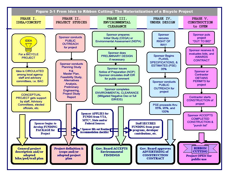
3 DEVELOPMENT OF THE BICYCLE PROJECT The general process by which a bicycle project evolves from an idea to an actual constructed and ridable facility is shown in the chart in Figure 3-1. The chart shows five main phases that proceed sequentially. These are: I. Idea/Concept (Often but not always from a bicycle plan, master plan or specific plan) II. Project Studies (Varies: feasibility studies, alternatives analyses, master plans, preliminary engineering, etc.) III. Environmental Clearance (CEQA requirements are a categorical exemption or an Initial Study leading to the preparation of a negative declaration, a mitigated negative declaration or an Environmental Impact Report. If federal funds are involved, then NEPA requirements must also be met.) IV. Design (Preparation of the PSE s: Plans -design drawings; Specifications written instructions for the contractor; and Estimates quantities and cost estimates to build the project.) V. Construction Figure 3-1 lists some of the many steps within each phase that culminate in the phase product and ultimately a built project. In reality, there are many interim optional steps, variations in the sequence of some of the steps and the first three or even four phases may overlap. There also may be other required elements depending on the complexity of the project, the approvals needed, the type of funding and available staffing resources. This chart is meant to be an informational tool, not a checklist. In addition, concurrently over several phases, the project gathers supporters and advocates and develops a funding package. In the absence of either of these two components, the project remains just an idea. This document is the idea / concept stage for many of the projects listed in this plan; while some projects have appeared in other plans, others appear here for the first time. Still other projects are well beyond the concept phase and some segments of them are even completed. Common examples of a project built in segments are the creek trails, since individual segments are usable while building an entire trail with many undercrossings is expensive. Page 3-3
4 Page 3-4
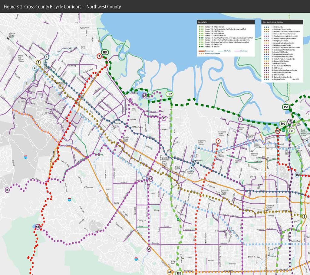
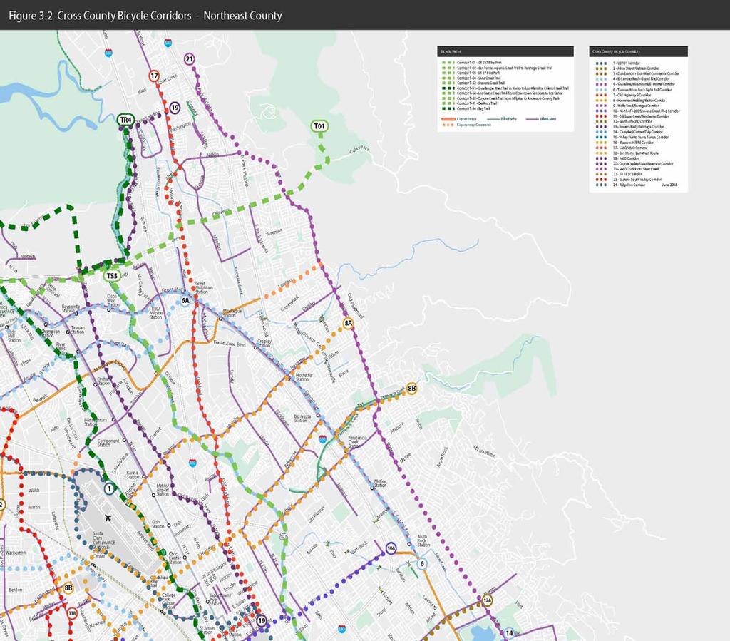
5 CROSS COUNTY BICYCLE CORRIDORS Purpose of the Cross County Bicycle Corridors The purpose of the Cross County Bicycle Corridors network is to provide continuous connections between Santa Clara county jurisdictions and to adjacent counties, and to serve the major regional trip-attractors in the County. The network fulfills the planning of a bicycle network portion of Policy A1 of the CBP first adopted in the Policy Framework of the 2000 Bike Plan. Projects located on CCBC s are by definition regional bike projects which can be funded through the VTA s Bicycle Expenditure Plan (BEP) projects, and may receive priority for future (yet-to-be-developed) funding sources. Ultimately a coordinated route-numbering and signing system will be developed in conjunction with the local jurisdictions. The signage will provide bicyclists (and other users) with the route number and/or name and the major destinations served by the routes. While neither roads nor trails nor expressways on their own appeal to all types of bicyclists all the time, collectively they serve virtually all bicyclists all the time. For example, bike paths are frequently unattractive to bicyclists who ride fast and/or are concerned about travel time; this is particularly true when the trails are crowded with non-cyclists such as joggers, dog walkers and children. But at other times, when there are few walkers and joggers, bike paths can be preferred by these same bicyclists for their low-stress experience, away from the noise and fumes of automobile traffic. Such is often the case during commute peak hours, since many trails peak use periods are on weekends and spring/summer evenings. There are also bicyclists who would never ride on busy roadways or expressways and will always prefer trails. Cross County Bicycle Corridor Alignments The 2000 Countywide Bicycle Plan identified 16 Cross-County Bicycle Corridors. Over the past eight years, various agencies and bicyclists have expressed a desire for more corridors to fully cover the County. The VTA BPAC and each jurisdiction in the County were asked to nominate additional routes for the cross county bicycle corridor system and /or to extend an existing corridor. For the most part, the corridors use city streets, ranging from major arterials to quiet residential streets. There are now 24 roadway routes plus all trails of regional significance as discussed in Chapter 1 and all County expressways. The cross county bicycle corridors are shown in Figure 3-2 and the primarily roadway corridors are listed in Table 3-1. The total length of the roadway network once completed will be about 500 miles. In addition, for serious cyclists there is the 62-mile expressway system, consisting of the seven expressways listed in Table 3-2. For cyclists of all ages, there are 17 trails; these are listed in Table 3-3. Appendix C2 contains a segment-by-segment description of the entire CCBC network. In many cases, roadways chosen for inclusion in the countywide bicycle network are existing bikeways or planned facilities included in the respective local bicycle plan. In Page 3-5
6 other cases, the roadway might not be included in the city plan, but was chosen because it provides the most logical connection between segments and/or directly serves popular regional destinations. Table 3-1: Cross County Bicycle Corridors (Roadways) Route No Name Limits 01 U.S. 101 Corridor San Mateo Cnty to San Benito Cnty 02 Alma Street/Caltrain Corridor San Mateo Cnty to Santa Clara 03 Dumbarton - East-West Connector Corridor North Palo Alto to Los Altos 04 El Camino -Grand Blvd Corridor San Mateo Cnty - Downtown San Jose 05 Shoreline-Miramonte/El Monte Corridor Mountain View to Los Altos 06 Tasman/ Alum Rock Light Rail Corridor Mountain View to East San Jose 07 Old Highway 9 Corridor No. Sunnyvale to Los Gatos 08 Homestead/Hostetter/Brokaw Corridor So. Los Altos to Northeast San Jose 09 Wolfe Rd /Borregas Corridor Sunnyvale to Saratoga 10 North of I-280/Stevens Creek Blvd Corridor Cupertino to Northern East San Jose 11 Calabazas Creek/Winchester Corridor Sunnyvale - Los Gatos 12 South of I-280 Corridor Cupertino to Hillview, east San Jose 13 Bowers / Kiely/ Saratoga Corridor No. Santa Clara to Skyline Blvd. 14 Campbell/Curtner/Tully Corridor Cupertino/Saratoga to Eastridge 15 Valley Fair to Santa Teresa Corridor Downtown Santa Clara to San Benito Cnty 16 Blossom Hill Rd. Corridor Saratoga to Southeast. San Jose 17 I-880/I-680 Corridor Alameda County to Los Gatos 18 San Martin east-west route Uvas Road to east side 19 I-880 Corridor Alameda Cnty to Downtown San Jose 20 Coyote Valley/ Uvas Reservoir Corridor South Cnty to SR I-680 Corridor to Silver Creek Alameda Cnty to South San Jose 22 Hwy 152 Corridor Santa Cruz Cnty line to Merced Cnty line 23 Eastern South Valley Corridor Morgan Hill, San Martin, Gilroy 24 Ridge Line Corridor Los Gatos to Mt. Madonna Page 3-6


7 Page 3-7
8 Page 3-8


9 Page 3-9

10 Page 3-10

11 Page 3-11
12 Cross County Bicycle Corridors and the County Expressway System The CCBC incorporates the entire County expressway system. The expressways are attractive to some bicyclists for the same reason that expressways provide better service to motorists: they are direct and continuous, have very few driveways and intersections are spaced widely apart, reducing over all travel time. In addition, they almost all have 8-foot shoulders, which are very suitable for experienced bicyclists. Sometimes expressways end abruptly from a bicyclist s point of view. So in most cases, we have included a local roadway as a connector road to and from the expressways from other CCBC s to provide better connectivity for bicyclists. The expressways are depicted in Figure 3-2 as solid lines, while the connector roadways are indicated in dotted lines of the same color. Table 3-2: Cross County Bicycle Corridors County Expressway System Number Name of Expressway Roadway Connector X-G02 Lawrence Expressway Quito Road X-G03 Oregon/Page Mill Expressway Page Mill Road X-G04 Montague/San Tomas Expressway Landess Avenue X-G05 Foothill Expressway Junipero Serra X-G06 Central Expressway De La Cruz Blvd. X-G08 Almaden Expressway Vine St /Almaden Av X-G21 Capitol Expressway E. San Antonio St. Note: The number beginning with G is the official County route number used by the Santa Clara County Roads and Airports Department. Cross County Bicycle Corridors and Regional Trails Regional trails, those that cross city and/or county lines or serve major destinations, provide significant transportation benefits to bicyclists. When trails have no or few atgrade crossings with roads, they function almost as bicycle freeways where travel is uninterrupted by stop signs and traffic signals. The CCBC incorporates all 13 trails from the County s Trails Master Plan(CTMP) that are designated regional and subregional; most of the significant trails planned and constructed in the last decade, whether by the County or by cities, fall into one of these categories. The CCBC s also include four other bike paths of regional significance including two trails in freeway rights-of-way. The CTMP s trails include both trails within urban / developed area of the County and in the hills surrounding the valley. It should be recognized that the CTMP is a very long range document; some trails are at a very conceptual stage and do not even have an identified alignment. These are mostly the trails in the unincorporated and undeveloped parts of the county where due to topography and grade, the trail would typically not be constructed as a class 1 Bike Path but as a single track trail on which bikes are allowed, They are cited here since they are contained the County Parks Trails Master Plan, but the alignment is not indicated on Figure 3-2. Page 3-12
13 As shown in Table 3-3, the trails cross jurisdictional lines and the same trail may have many different managers. The many trail operators involved in the management and operation of these trails have resulted in inconsistent hours of operation for bike paths; the same trail can have up to four different operating hours as it traverses four different agencies boundaries. This is counterproductive to the role that bike paths play in the transportation network. VTA views bike paths as part of an integrated, multimodal, countywide and regional transportation system consistent with the TEA-21 federal mandate to develop transportation facilities that will function as an intermodal transportation system. As such, VTA is committed to working with trail managers in order to provide a consistent operation policy countywide so that bicycle commuters will be able to use bike paths as freely as they can bike lanes and bike routes. For more discussion, see VTA s Bicycle Technical Guidelines, Chapter 9. Table 3-3: Cross County Bicycle Corridors Bike Paths/Trails (Existing and/or Proposed) Number Trail Name Responsible Agency Phase Status T01 Highway 237 Trail Caltrans / City of San Jose Open T02/T-C5 San Tomas Aquino Creek Santa Clara, San Jose, Cupertino Varies from Open to Trail under design T03 Highway 87 Trail Caltrans/ City of San Jose Open T04 Uvas Creek Trail Gilroy, Santa Clara County Open to Under Design T-R1 Anza National Historic Trail (Planning assistance from the National Park Service) To be determined (City of Saratoga s De Anza Trail on PGE right of way could be added as a segment of this trail). Santa Clara County, San Benito County T-R2 Monterey-Yosemite State* Trail T-R3 Benito-Clara Trail * Morgan Hill, Santa Clara County, Gilroy, CA State Parks T-R4 Bay Trail (Planning assistance from ABAG) Palo Alto, Mt View, Sunnyvale, CalTrans, USFWS, San Jose, Milpitas Open: 99 miles; Conceptual project: 113 miles Conceptual project (30 miles) Conceptual project (59 miles) Varies from Open to Conceptual project T-R5 Bay Area Ridge Trail* To be determined Open 74 miles; Conceptual project: 121 miles T-S1 Matadero Creek/Page Mill Trail * Palo Alto, Los Altos Hills, Stanford University, MROSD T-S2 Stevens Creek Trail Mountain View, Sunnyvale, Los Altos, Cupertino, MROSD, Santa Clara County T-S3 Guadalupe River/Los Alamitos Creek/Calero Creek Trail System San Jose, Santa Clara, Santa Clara County varies from Open to Conceptual project (11.5 miles) Varies from Open to under design Varies from Open to Conceptual project T-S4 Los Gatos Creek Trail San Jose, Campbell, Los Gatos, County Varies from Open to Conceptual project Page 3-13
14 Number Trail Name Responsible Agency Phase Status T-S5 Coyote Creek Trail/Llagas Creek Trail Milpitas, San Jose, Gilroy, Santa Clara County, Morgan Hill, SCVWD Varies from Open to Conceptual project T-S6 West Valley Trail* Gilroy, City of San Jose, Santa Clara County Varies from Open to Conceptual project T-S7 Morgan Hill Cross-Valley Trail * Santa Clara County, Morgan Hill Conceptual project (11 miles) T-S8 San Martin Cross-Valley Trail* Santa Clara County Conceptual project (2.6 miles) *Trail alignment not shown on Figure 3-2 Trail numbers with an R, S or C reflect the trail number in the Santa Clara County Parks and Recreation Department Trails Master Plan, 1995 Phase Status - see Figure 3-1 for an explanation of these terms CROSS COUNTY BICYCLE CORRIDOR PROJECTS The general types of projects needed to fully complete the CCBC network have been categorized as follows; the specific projects by location are presented in Chapter New Bike Path Construction or paving of existing gravel path 2. Across Barrier Connection (ABC) for bicycles and pedestrians. These can be either bridges/overcrossings or tunnels/undercrossings (or, at railroad tracks, at-grade crossings). 3. Bike Lanes, ideally. 4. Redesign Freeway Interchange to be bike- friendly. 5. New road with bike lanes. 6. Improvement needed for existing facility exact improvement varies. These may include any or all of the bike-friendly treatments described in the VTA Bicycle Technical Guidelines Chapters 3, 5 and 6 such as restriping for wider curb lanes, signal timing and detection, and right-turn modifications. 7. Signing as bike route; traffic calming if necessary. 8. Bicycle Boulevard, improvements vary; see VTA Bicycle Technical Guidelines Chapter Shoulders - widening and/or restriping to two feet in width 10. Shoulders - widening and/or restriping to four to eight feet in width 11. Expressway, exact improvement varies; see Santa Clara County Expressway Master Plan, Bicycle Element. TRANSIT STATION ACCESS PROJECTS Since the 2000 Countywide Bicycle Plan, there has been an emphasis on Safe Routes to Transit and Livable Communities in transportation funding priorities. Since VTA is the County s transit operator, it makes good planning sense for VTA to help plan for safe and convenient routes to the major transit centers it operates. Projects are potentially eligible for the Safe Routes to Transit grants managed by MTC on behalf of Regional Measure 2. A ready list of projects will put VTA and Member Agencies in a better position to apply to future Call for Projects. The projects that improve bike access to Page 3-14
 AND ROADWAY CROSSINGS INVENTORY One of the concepts of Livable Communities is to de-emphasize travel by auto in favor of quieter, less polluting modes such as")
 and/or pedestrians (sidewalks).")
15 VTA transit centers; Caltrain, ACE or Amtrak stations; and/or light rail stations that were submitted by Member Agencies are presented in Chapter 4. ACROSS BARRIER CONNECTIONS (ABC S) AND ROADWAY CROSSINGS INVENTORY One of the concepts of Livable Communities is to de-emphasize travel by auto in favor of quieter, less polluting modes such as walking and biking. Chapter 2 described and Figure 2-1 illustrated how freeways, rivers, creeks and railroad tracks crisscross the county creating impermeable barriers for pedestrians and bicyclists. Even when roadways cross these barriers, they are often inadequate or have no accommodations for bicycles (bike lanes or shoulders) and/or pedestrians (sidewalks). By providing connections across the major barriers in the county, walking and biking distances can be reduced dramatically, thereby increasing their feasibility for more types of trips. Fully one-fourth of the bicycle-projectwish-list compiled by the Silicon Valley Bicycle Coalition is comprised of overcrossings (bridges) or undercrossings (tunnels). To assess the extent to which these barriers restrict nonmotorized mobility, VTA and Member Agencies conducted an inventory of every Discontinuous Brokaw Rd resulting in 1.6 miles between crossings of the train tracks. Existing legal way to cross Caltrain tracks at the Santa Clara station a 1.1 mile detour. freeway, waterway and railroad crossing in the developed parts of the County i.e. all bridges, tunnels and at-grade rail crossings for both motor vehicles and for nonmotorized users. The inventory consisted of jurisdiction, location, spacing, width, and if a roadway crossing, presence of bike lanes or shoulders between crossings. The non motorized crossings are referred to collectively as Across Barrier Connections (ABCs). Phase 1 - Inventory of Bike/Pedestrian Across Barrier Connections (ABC s) There are currently 92 ABC s in Santa Clara County: 32 at freeways, 16 bike/ped crossings of Caltrain or UPRR tracks, (of which 13 are grade-separated and three are atgrade), and 44 ped/bike bridges over creeks and rivers. The 32 freeway ABC s includes the three that are currently under construction at 280/Mary Ave, 101/ Borregas and 237/Borregas. Of these 92, two are considered obsolete and need replacing, both in Palo Alto: the Caltrain tracks undercrossing at California Ave which does not meet Page 3-15
16 ADA accessibility guidelines, and the US 101 under-crossing near Adobe Creek, which is closed due to flooding in the winter. This data is summarized in Table 3-4. Phase 2 - Inventory of Roadway Crossings The presence or absence of bike lanes, shoulders and sidewalks on the arterial and collector roadways was identified with the help of city staff and BPAC members. If an arterial or collector roadway has a bike lane or wide shoulder (4 ft. or wider), it was considered to have adequate bicycle provisions. If it did not, it was rated as having inadequate bike provisions. All local roadways (i.e. not an arterial or collector), all pedestrian/bike-only bridges/tunnels, and all pedestrian/bike-only at-grade crossings were considered adequate by definition. As presented in Table 3-4, there are 44 adequate roadway crossings of freeways, 127 adequate roadway crossings of railroad tracks, and 259 adequate roadway crossings of creeks. Of the 197 inadequate roadway crossings i.e. without bike lanes or shoulders, 94 are roadway crossings of freeways (both at and not at interchanges), 32 are roadway crossings of Existing Railroad At-grade Crossings In 2007 as a separate effort under the rail program, VTA conducted a study of all existing roadway and pedestrian at-grade crossings of the Caltrain tracks in Santa Clara County. This analysis identified short-term feasible pedestrian and bike safety improvements; these projects are being funded over the next five years ( ) under a separate VTA program. railroad tracks (both at-grade and grade-separated) and 71 are roadway bridges over creeks. These are discussed further as potential projects in Chapter 4. Phase 3 - Identification of Gaps The third phase of the inventory was to identify gaps of a mile or more between existing crossings (adequate and inadequate). Those segments that lack adjacent land uses of sufficient density (either existing or planned) and therefore have low potential for latent demand for crossing were filtered out, (for example across I-280 in Los Altos Hills). All remaining locations were considered potential crossing locations, and indeed many of these are the sites of ABCs in some level of project development. A summary of these 109 locations is presented in Table 3-4, and specific project locations are discussed further in Chapter 4. Page 3-16
17 Barrier I-280 Table 3-4: Summary of Bike Access Across Major Barriers # of Existing ABC s 5 (includes Mary Ave under construction) Roadway Crossings (includes freeway interchanges) # of Existing # of Existing Adequate Inadequate Crossings Crossings I I SR SR 237 1(includes Borregas Ave under construction) SR SR US 101 SUBTOTAL (freeways) 7 1 (includes Borregas Ave under construction) # of Planned or Potential ABC s # of Gaps Other Caltrain tracks UP/ ACE Tracks SUBTOTAL (rail tracks) Coyote Creek Guadalupe River Saratoga Creek Los Gatos Creek San Tomas Aquino Creek Stevens Creek Llagas Creek Uvas Creek Other Creeks SUBTOTAL (creeks) TOTAL Page 3-17
; or the at-grade crossing of railroad tracks.")
18 Table 3-4: Summary of Bike Access Across Major Barriers NOTES : ABC = Across Barrier Connection: a bike/ped only bridge/ tunnel of a freeway, creek or railroad, or an at-grade pedestrian crossing of railroad tracks. Roadway Crossing = that portion of a roadway that crosses over or under a freeway, railroad or waterway, (i.e. the grade-separated part of the roadway); or the at-grade crossing of railroad tracks. Adequate Roadway Crossing = a roadway is considered to provide adequate bike access if it is a collector or arterial roadway and it has bike lanes or wide shoulders or it is a local road with traffic low volumes. Inadequate Roadway Crossing = a roadway is considered to provide inadequate bike access if it is a collector or arterial and does not have bike lane or wide shoulders. Planned or Potential ABC = Large Gap ( 0.9 mile) between existing barrier crossings Note 1 : Includes one existing ABC that is obsolete and needs replacing; See discussion on page Note 2 : Includes: Adobe Creek, Berryessa Creek, Calabazas Creek, Calera Creek, Hale Creek, Little Llagas Creek, Los Alamitos Creek, Matadero Creek, Penitencia Creek, Permanente Creek, Ross Creek, San Francisquito Creek, Silver Creek, and Thompson Creek Homer Avenue Undercrossing of Caltrain in Palo Alto Opened 2005 Page 3-18
SANTA CLARA COUNTYWIDE BICYCLE PLAN August 2008
 SANTA CLARA COUNTYWIDE BICYCLE PLAN August 2008 To assist VTA and Member Agencies in the planning, development and programming of bicycle improvements in Santa Clara County. Vision Statement To establish,
Santa Clara I-280 CORRIDOR STUDY
 Santa Clara I-280 CORRIDOR STUDY OCTOBER 2017 PREPARED BY: 1.1 Background The I-280 Corridor Study within Santa Clara County is a high-level highway planning study led by the Santa Clara VTA, in partnership
POTENTIAL SANTA CLARA COUNTY TRANSPORTATION MEASURE
 POTENTIAL SANTA CLARA COUNTY TRANSPORTATION MEASURE OVERALL DRAFT EXPENDITURE PLAN TRANSIT/Mode Shift Millions % BART to Downtown San Jose/Santa Clara* 1,400 23% Caltrain Capacity & Safety 1,014 17% Mass
FOR INFORMATION ONLY
 9 Date: August 6, 2012 Current Meeting: August 16, 2012 Board Meeting: September 6, 2012 BOARD MEMORANDUM TO: THROUGH: FROM: SUBJECT: Santa Clara Valley Transportation Authority Congestion Management Program
Bike San Mateo County San Mateo County Bicycle Plan Recommendations August 30, 2010
 Policy and Procedures Develop and Implement a Complete Streets Policy to comply with DD-64-R1 and AB1358 Commencing January 1, 2011, AB1358 requires that the legislative body of a city or county, upon
PURPOSE AND POLICY GUIDANCE
 1 PURPOSE AND POLICY GUIDANCE The VTA Bicycle Technical Guidelines (BTG) present standards and guidance for planning, designing, operating, retrofitting and maintaining roadways and bikeways. They are
TRANSPORTATION TRAINING TOPICS. April 6, 2010
 TRANSPORTATION TRAINING TOPICS April 6, 2010 Roles of Transportation Providers Context and Policy Makers Division of Transportation and Traffic Other City Operations Other Transportation Operators CMA
Circulation in Elk Grove includes: Motor vehicles, including cars and trucks
 Circulation, as it is used in this General Plan, refers to the many ways people and goods move from place to place in Elk Grove and the region. Circulation in Elk Grove includes: Motor vehicles, including
Clackamas County Comprehensive Plan
 ROADWAYS The County s road system permits the movement of goods and people between communities and regions, using any of a variety of modes of travel. Roads provide access to virtually all property. They
Los Altos Hills Town Council - June 18, 2015 Palo Alto City Council June 22, AGENDA ITEM #2.B Presentation
 Los Altos Hills Town Council - June 18, 2015 Palo Alto City Council June 22, 2015 AGENDA ITEM #2.B Presentation Previous Presentations Los Altos Hills Town Council in May 2014 and February 2015 Palo Alto
INTRODUCTION. The focus of this study is to reduce congestion and improve mobility for all modes of transportation. Figure ES-1 Study Corridor Map
 INTRODUCTION The I-280 Corridor Study is a highway planning study led by Santa Clara VTA, in partnership with the City of Cupertino and in coordination with other stakeholders in the study area. The study
San Tomas Expressway
 Implementation Plan San Tomas Expressway Roads and Airports Department August 19, 2003 Implementation Plan San Tomas Expressway County of Santa Clara Roads and Airports Department 101 Skyport Drive San
Purpose and Need. Chapter Introduction. 2.2 Project Purpose and Need Project Purpose Project Need
 Chapter 2 Purpose and Need 2.1 Introduction The El Camino Real Bus Rapid Transit (BRT) Project (Project) would make transit and other transportation improvements along a 17.6-mile segment of the El Camino
FROM: CITY MANAGER DEPARTMENT: PLANNING AND COMMUNITY ENVIRONMENT DATE: OCTOBER 4, 2004 CMR:432:04
 TO: HONORABLE CITY COUNCIL FROM: CITY MANAGER DEPARTMENT: PLANNING AND COMMUNITY ENVIRONMENT DATE: OCTOBER 4, 2004 CMR:432:04 SUBJECT: FINANCE COMMITTEE RECOMMENDATION TO ADOPT TRANSPORTATION STRATEGIC
Solana Beach Comprehensive Active Transportation Strategy (CATS)
") Solana Beach Comprehensive Active Transportation Strategy (CATS) 3.0 Goals & Policies The Solana Beach CATS goals and objectives outlined below were largely drawn from the Solana Beach Circulation Element
Solana Beach Comprehensive Active Transportation Strategy (CATS) 3.0 Goals & Policies The Solana Beach CATS goals and objectives outlined below were largely drawn from the Solana Beach Circulation Element
BICYCLE & PEDESTRIAN ADVISORY COMMITTEE MINUTES
 CALL TO ORDER BICYCLE & PEDESTRIAN ADVISORY COMMITTEE Wednesday, November 9, 2016 MINUTES The Regular Meeting of the Bicycle and Pedestrian Advisory Committee (BPAC) was called to order at 6:30 p.m. by
San Mateo County Comprehensive Bicycle and Pedestrian Plan Open House
 San Mateo County Comprehensive Bicycle and Pedestrian Plan Open House October 28, 2010 Presented to San Mateo County residents and interested parties by Lauren Ledbetter, Alta Planning + Design Matt Haynes,
5. RUNNINGWAY GUIDELINES
 5. RUNNINGWAY GUIDELINES These guidelines should be considered collectively when making runningway decisions. A runningway is the linear component of the transit system that forms the right-of-way reserved
NM-POLICY 1: Improve service levels, participation, and options for non-motorized transportation modes throughout the County.
 Transportation PRINCE WILLIAM COUNTY 2008 COMPREHENSIVE PLAN NON-MOTORIZED PLAN CONTENTS Goals, Policies, and Action Strategies Table 4 (Bike Facility Classifications and Descriptions) Table 5 (Bike Facility
Appendix 3 Roadway and Bike/Ped Design Standards
 Appendix 3 Roadway and Bike/Ped Design Standards OTO Transportation Plan 2040 4/20/2017 Page A3-1 Adopted Standards The adopted OTO Design Standards and Major Thoroughfare Plan are contained herein.
CITY OF ELKO BICYCLE AND PATHWAY PLAN
 CITY OF ELKO BICYCLE AND PATHWAY PLAN INTRODUCTION: The City of Elko is intended to provide the basic framework for the development of a functional bicycle and pathway system for the community with connections
General Design Factors
 Chapter 3: 3-1.0 Introduction General Design Factors Mn/DOT s goals include encouraging and accommodating safe bicycling. From a design perspective, these goals are achieved by first having an understanding
Chapter 2 Current Conditions and Settings
 Chapter 2 Current Conditions and Settings PHYSICAL SETTING Santa Clara Valley is home to the Silicon Valley with roughly 4,100 high-technology firms and about 30% of the Bay Area s jobs. The north County,
CITY OF COCOA BEACH 2025 COMPREHENSIVE PLAN. Section VIII Mobility Element Goals, Objectives, and Policies
 CITY OF COCOA BEACH 2025 COMPREHENSIVE PLAN Section VIII Mobility Element Goals, Objectives, and Policies Adopted August 6, 2015 by Ordinance No. 1591 VIII MOBILITY ELEMENT Table of Contents Page Number
ACTIVE TRANSPORTATION
 ACTIVE TRANSPORTATION Mobility 2040 Supported Goals Improve the availability of transportation options for people and goods. Support travel efficiency measures and system enhancements targeted at congestion
4. ENVIRONMENTAL IMPACT ANALYSIS 9. TRANSPORTATION AND TRAFFIC
 4. ENVIRONMENTAL IMPACT ANALYSIS 9. TRANSPORTATION AND TRAFFIC 4.9.1 INTRODUCTION The following section addresses the Proposed Project s impact on transportation and traffic based on the Traffic Study
Living Streets Policy
 Living Streets Policy Introduction Living streets balance the needs of motorists, bicyclists, pedestrians and transit riders in ways that promote safety and convenience, enhance community identity, create
TABLE OF CONTENTS. Executive Summary
 Executive Summary Background... ES-1 Pedestrian Network... ES-2 Bikeway Network... ES-2 Collision History... ES-2 Public Input... ES-4 Conclusions and Recommendations... ES-4 1. Introduction and Setting
Chapter 7. Transportation. Transportation Road Network Plan Transit Cyclists Pedestrians Multi-Use and Equestrian Trails
 Chapter 7 Transportation Transportation Road Network Plan Transit Cyclists Pedestrians Multi-Use and Equestrian Trails 7.1 TRANSPORTATION BACKGROUND The District of Maple Ridge faces a number of unique
VTP 2040 Multimodal Transportation Investment Projects
 Campbell 240509 B1 Los Gatos Creek Trail Expansion on West Side (Hamilton to Campbell) $2.9 240509 B2 Widen Los Gatos Creek Trail on East Side (Camden to Campbell) $0.3 240509 B3 San Tomas Aquino Creek
Chapter 3: Multi-Modal Circulation and Streetscapes
 CHAPTER 3: MULTI-MODAL CIRCULATION AND STREETSCAPES Chapter 3: Multi-Modal Circulation and Streetscapes Overview Streetscape improvements have already been completed for Depot Street between Main Avenue
Route 7 Corridor Study
 Route 7 Corridor Study Executive Summary Study Area The following report analyzes a segment of the Virginia State Route 7 corridor. The corridor study area, spanning over 5 miles in length, is a multi
CONNECTING PEOPLE TO PLACES
 CONNECTING PEOPLE TO PLACES 82 EAST BENCH MASTER PLAN 07 Introduction The East Bench transportation system is a collection of slow moving, treelined residential streets and major arteries that are the
NEPA and CEQA Transportation Operation Analysis
 3.1 Introduction Chapter 3 Transportation Operation Analysis This chapter includes a transportation analysis of the operational impacts of the following: The National Environmental Policy Act (NEPA) Alternatives
ACTIVE TRANSPORTATION/NONMOTORIZED TRANSPORTATION
 ACTIVE TRANSPORTATION/NONMOTORIZED TRANSPORTATION BACKGROUND Active transportation, also known as nonmotorized transportation, is increasingly recognized as an important consideration when planning and
Multimodal Through Corridors and Placemaking Corridors
 68 Multimodal Through Corridors and Placemaking Corridors Corridors have different functions in a region. Some corridors are used to get smoothly and rapidly through a region or to get quickly to major
5/31/2016 VIA . Arwen Wacht City of Sacramento Community Development Department 300 Richards Blvd., 3 rd Floor Sacramento, CA 95811
 5/31/2016 VIA EMAIL Arwen Wacht City of Sacramento Community Development Department 300 Richards Blvd., 3 rd Floor Sacramento, CA 95811 RE: El Pollo Loco (P16-028) Dear Ms. Wacht: WALKSacramento has reviewed
2.0 Existing Conditions
 20 2.0 Existing Conditions 2.1 Land Use, Future Growth Patterns, Physical Barriers Geographic Overview Sutter County s land use pattern is characterized by extensive agricultural areas, significant natural
Active Transportation Facility Glossary
 Active Transportation Facility Glossary This document defines different active transportation facilities and suggests appropriate corridor types. Click on a facility type to jump to its definition. Bike
EXECUTIVE SUMMARY... vii 1 STUDY OVERVIEW Study Scope Study Area Study Objectives
 Contents EXECUTIVE SUMMARY... vii 1 STUDY OVERVIEW... 1-1 1.1 Study Scope... 1-1 1.2 Study Area... 1-1 1.3 Study Objectives... 1-3 2 EXISTING CONDITIONS... 2-1 2.1 Existing Freeway Conditions... 2-4 2.1.1
Madison Urban Area and Dane County. Bicycle Transportation Plan Summary. September Introduction. Bicycle Plan Scope and Planning Process
 Bicycle Transportation Plan Summary Madison Urban Area and Dane County Introduction September 2000 Bicycling is an important mode of transportation in the Madison urban area and countywide that is available
TRANSPORTATION COMMISSION Agenda Staff Report
 TRANSPORTATION COMMISSION Agenda Staff Report Agenda Item No. 5.a DATE: JULY 31, 2014 TO: FROM: SUBJECT: TRANSPORTATION COMMISSION COMMUNITY DEVELOPMENT DEPARTMENT - PLANNING DRAFT OLYMPIC CORRIDOR PREFERRED
NOTICE OF PREPARATION. Environmental Programs 3331 North First Street, Building B-2 San Jose, CA
 NOTICE OF PREPARATION May 29, 2018 To: Reviewing Agencies and Organizations From: Santa Clara Valley Transportation Authority Environmental Programs 3331 North First Street, Building B-2 San Jose, CA 95134-1927
US 101 Express Lanes Project Open House WELCOME! Want to learn more?
 Silicon Valley Express Lanes US Project Environmental Phase US Express Lanes Project Open House WELCOME! Want to learn more? VTA staff members are ready to answer your questions! Here is how: 1. Watch
Physical Implications of Complete Streets Policies
 Presentation Overview Physical Implications of Complete Norm Cox, ASLA, LLA Landscape Architect Ann Arbor, Michigan, 10:45 to Noon What Are Complete Streets? What Matters to Bicyclists and Pedestrians
San Jose Transportation Policy
 San Jose Transportation Policy Protected Intersections in LOS Policies to Support Smart Growth Presented by: Manuel Pineda City of San Jose Department of Transportation Bay Area Map San Francisco Oakland
Expressway Plan 2040 Fact Sheet
 Expressway Plan 2040 Fact Sheet AGENDA ITEM #2.B Expressway Plan 2040 is the successor to the 2003 Comprehensive County Expressway Planning Study and 2008 Update. The 2003 Study developed and documented
Chapter 5 Future Transportation
 Chapter 5 Future Transportation The Future Land Use Plan identifies the desired land use designations. The land uses desired for Crozet depend, in large part, on the success of the transportation system,
Chapter 4 Projects, Funding and Implementation
 Chapter 4 Projects, Funding and Implementation This chapter presents the capital projects to complete the countywide network described in Chapter 3. This chapter then describes the Bicycle Expenditure
EL CAMINO REAL BUS RAPID TRANSIT (BRT) PROJECT
 PROJECT") Agenda Item #4.2 EL CAMINO REAL BUS RAPID TRANSIT (BRT) PROJECT VTA BOARD WORKSHOP MAY 1, 2015 ABOUT THIS PRESENTATION CONTEXT Existing conditions and planning for growth WHAT IS THE PROJECT? Project alternatives
Agenda Item #4.2 EL CAMINO REAL BUS RAPID TRANSIT (BRT) PROJECT VTA BOARD WORKSHOP MAY 1, 2015 ABOUT THIS PRESENTATION CONTEXT Existing conditions and planning for growth WHAT IS THE PROJECT? Project alternatives
1.0 INTRODUCTION 1.1 PURPOSE OF THIS REPORT
 1.0 INTRODUCTION This chapter provides an overview of the purpose, authorization and focus of this Recirculated Draft Environmental Impact Report (EIR), an identification of the Lead Agency, an outline
Bicycle and Pedestrian Chapter TPP Update Overview. TAB September 20, 2017
 Bicycle and Pedestrian Chapter TPP Update Overview TAB September 20, 2017 Bicycling & Walking in the Twin Cities Where are we now? The Bike-Pedestrian system Current trends New developments Where are we
Planning Guidance in the 2012 AASHTO Bike Guide
 Planning Guidance in the 2012 AASHTO Bike Guide Presentation by: RJ Eldridge Peter Lagerwey August 22, 2012 WEBINAR 2: PLANNING GUIDANCE IN THE 2012 AASHTO BIKE GUIDE Today s Webinar Significant Updates
REGIONAL BICYCLE AND PEDESTRIAN DESIGN GUIDELINES
 REGIONAL BICYCLE AND PEDESTRIAN DESIGN GUIDELINES November 16, 2011 Deb Humphreys North Central Texas Council of Governments Bicycle and Pedestrian Advisory Committee Snapshot of the Guide 1. Introduction
3.9 Recreational Trails and Natural Areas
 3.9 Recreational Trails and Natural Areas 3.9.1 Introduction Parks and other recreational facilities such as trails, bicycle routes, and open space are important community resources. This section discusses
Chapter 6 Transportation Plan
 Chapter 6 Transportation Plan Transportation Plan Introduction Chapter 6 Transportation Plan Transportation Plan Introduction This chapter describes the components of Arvada s transportation system, comprised
Basalt Creek Transportation Refinement Plan Recommendations
 Basalt Creek Transportation Refinement Plan Recommendations Introduction The Basalt Creek transportation planning effort analyzed future transportation conditions and evaluated alternative strategies for
FUNDING SOURCES CHAPTER 6
 CHAPTER 6 6.1 BICYCLE 6.1.1 Local 6.1.2 Regional 6.1.3 State 6.1.4 Federal 6.1.5 Public Facilities 6.1.6 Bicycle Registration and Licensing Fees 6.1.7 Summary Table 6.1 of Bicycle Funding Sources 6 2 6.2
summary of issues and opportunities
 1 summary of issues and opportunities EXECUTIVE SUMMARY CHAPTER 2: HISTORY - 3: LAND USE This first chapter is an overview of lessons learned from analysis of the existing conditions on El Camino as well
Highway 111 Corridor Study
 Highway 111 Corridor Study June, 2009 LINCOLN CO. HWY 111 CORRIDOR STUDY Draft Study Tea, South Dakota Prepared for City of Tea Sioux Falls Metropolitan Planning Organization Prepared by HDR Engineering,
Magnolia Place. Traffic Impact Analysis. Prepared for: City of San Mateo. Prepared by: Hexagon Transportation Consultants, Inc.
 Magnolia Place Traffic Impact Analysis Prepared for: City of San Mateo Prepared by: Hexagon Transportation Consultants, Inc. Updated January 4, 2010 Table of Contents 1. Introduction...1 2. Existing Conditions...6
City of Gainesville Transportation/Roadway Needs PROJECT SUMMARY
 A1 Roadway Resurfacing $23,846,000 TYPE: Preservation of existing system Roadway resurfacing A2 Signal Replacement $6,000,000 TYPE: Preservation of existing system Replace traffic signals. B1 W 6th St
FEDERAL HIGHWAY ADMINISTRATION APPLICATION
 FEDERAL HIGHWAY ADMINISTRATION APPLICATION REQUEST FOR PERMISSION TO EXPERIMENT WITH A BICYCLE BOX INTERSECTION TREATMENT Submitted by: City of Columbus Department of Public Service Date: June 26, 2009
City of Novi Non-Motorized Master Plan 2011 Executive Summary
 City of Novi Non-Motorized Master Plan 2011 Executive Summary Prepared by: February 28, 2011 Why Plan? Encouraging healthy, active lifestyles through pathway and sidewalk connectivity has been a focus
Classification Criteria
 SCHEDULE D TO RECOMMENDED OFFICIAL PLAN AMENDMENT NO. 40 SCHEDULE C-4 Road Criteria Criteria Traffic Service Objective Land Service/Access Typical Daily Traffic Volume Flow characteristics Travel Speed
o n - m o t o r i z e d transportation is an overlooked element that can greatly enhance the overall quality of life for the community s residents.
 N o n - m o t o r i z e d transportation is an overlooked element that can greatly enhance the overall quality of life for the community s residents. 84 Transportation CHAPTER 11 INTRODUCTION Transportation
Figure shows the existing roadway network in Daly City.
 The following section presents a description of various transportation system components within Daly City. Interstate 280 (I-280), State oute (S-), Skyline Boulevard (S-) and Mission Street (S-82) all
BICYCLE & PEDESTRIAN ADVISORY COMMITTEE MINUTES
 BICYCLE & PEDESTRIAN ADVISORY COMMITTEE Wednesday, March 7, 2007 MINUTES 1. CALL TO ORDER The Regular Meeting of the Valley Transportation Authority (VTA) Bicycle and Pedestrian Advisory Committee (BPAC)
Rochester Downtown Bicycle Study 2009
 Rochester Downtown Bicycle Study 2009 Relationship of ROCOG Long Range Transportation Plan to Rochester Comprehensive Plan Regional Long Range Transportation Plan (LRTP) is prepared under the auspices
This page intentionally left blank.
 This page intentionally left blank. COMMUNITY Coweta Community Overview Coweta Coweta, a residential community located in Wagoner County, is a suburb of Tulsa situated southeast of the metropolitan area
Non-Motorized Transportation 7-1
 Non-Motorized Transportation 7-1 Transportation facilities no longer mean just accommodating a vehicle powered by a combustion engine. Pedestrian and non-motorized facilities are important modes of travel
2040 RTP. Chapter 6: Investments in our Transportation Future
 2040 RTP Chapter 6: Investments in our Transportation Future This chapter describes the transportation investments proposed for the San Benito region that support the goals and objectives of the Regional
Staff Report City of Manhattan Beach
 Agenda Item #: Staff Report City of Manhattan Beach TO: THROUGH: FROM: Honorable Mayor Wilson and Members of the City Council Geoff Dolan, City Manager Richard Thompson, Director of Community Development
CITY OF BLOOMINGTON COMPLETE STREETS POLICY
 CITY OF BLOOMINGTON COMPLETE STREETS POLICY POLICY OBJECTIVE: The City of Bloomington will enhance safety, mobility, accessibility and convenience for transportation network users of all ages and abilities,
Corpus Christi Metropolitan Transportation Plan Fiscal Year Introduction:
 Introduction: The Safe, Accountable, Flexible, Efficient Transportation Equity Act: A Legacy for Users (SAFETEA-LU) has continued the efforts started through the Intermodal Surface Transportation Efficiency
RZC Appendix 8A Marymoor Subarea Street Requirements
 RZC Appendix 8A Marymoor Subarea Street Requirements For additional design details for Marymoor Subarea infrastructure, refer to the 2017 Marymoor Subarea Infrastructure Planning Report. STREET REQUIREMENTS
Bicycle Master Plan Goals, Strategies, and Policies
 Bicycle Master Plan Goals, Strategies, and Policies Mobilizing 5 This chapter outlines the overarching goals, action statements, and action items Long Beach will take in order to achieve its vision of
5/7/2013 VIA . RE: University Village Safeway Expansion (P13-019)
") 5/7/2013 VIA EMAIL David Hung, Associate Planner Community Development Department, Current Planning Division City of Sacramento 300 Richards Boulevard, 3 rd Floor Sacramento, CA 95811 RE: University Village
5/7/2013 VIA EMAIL David Hung, Associate Planner Community Development Department, Current Planning Division City of Sacramento 300 Richards Boulevard, 3 rd Floor Sacramento, CA 95811 RE: University Village
Gordon Proctor Director Policy on Accommodating Bicycle and Pedestrian Travel on ODOT Owned or Maintained Facilities
 Approved: Policy: 20-004(P) Responsible Office: Planning Gordon Proctor Director Policy on Accommodating Bicycle and Pedestrian Travel on ODOT Owned or Maintained Facilities I. POLICY STATEMENT: This policy
I will attend tonight's meeting to summarize this proposal during my public comment. Thank you.
 Grossman, Rachel M From: Andrew Boone Sent: Wednesday, January 11, 2012 2:29 PM To: thprop@earthlink.net; nate.menlopark@gmail.com; Bianca.walser@gmail.com; Mshiu147@gmail.com; menlo.commish.mueller@gmail.com;
Omaha s Complete Streets Policy
 Omaha s Complete Streets Policy (Adopted August 2015) VISION To create great places and enhance our quality of life, the City of Omaha will provide safe, accessible streets for all users. Complete Streets
Development Review Program Annual Report 2016
 Development Review Program Annual Report 2016 Web version Spring 2017 http://museumplacesanjose.com/ http://www.elcaminohospital.org City of Campbell Council Agenda Packet 9/13/16 Gunter Lofts Development
Circulation. Section INTRODUCTION CONTENTS
 Section 4 Circulation 4-1 Environmental Resources/ Sustainability Housing CONTENTS 4-1 Introduction 4-2 Regional Transportation Planning 4-5 Encouraging Alternatives to the Automobile 4-6 Pedestrians and
Appendix T CCMP TRAIL TRAFFIC & TRANSPORTATION DESIGN STANDARD
 Appendix T CCMP 3.3.4 TRAIL TRAFFIC & TRANSPORTATION DESIGN STANDARD 3.3.4 Trail Traffic and Transportation Design Multi-use trails have certain design standards, which vary depending on the agency that
Duwamish Way-finding and CTR Report
 V. North Tukwila When the North Tukwila Manufacturing and Industrial Center was designated in 1992 as part of the region s land use and transportation plan, the plan called for the area to set a light-rail
El Camino Real Bus Rapid Transit Conceptual Engineering. Los Altos Council Workshop January 24, 2012
 El Camino Real Bus Rapid Transit Conceptual Engineering Los Altos Council Workshop January 24, 2012 Agenda Introduction Growth in the El Camino Real Corridor Benefits of BRT El Camino Real BRT Decision
SECTION 1 - TRAFFIC PLANNING
 SECTION 1 - TRAFFIC PLANNING 1.1 TRAFFIC OPERATIONS 1.1.1 Roadway Functional Classification The Multnomah County Comprehensive Framework Plan s Policy 34: Trafficways and the Functional Classification
Overview. Illinois Bike Summit IDOT Complete Streets Policy Presentation. What is a Complete Street? And why build them? And why build them?
 Overview Illinois Bike Summit IDOT Complete Streets Policy Presentation Aren Kriks, P.E. District One Bicycle Coordinator and Bureau of Programming Project Engineer History of Complete Streets IDOT Policy
Bikeway action plan. Bicycle Friendly Community Workshop March 5, 2007 Rochester, MN
 Bikeway action plan Summary The was held on March 5, 2007 at the Rochester Mayo Civic Center. The workshop was hosted by Rochester-Olmsted County Planning Department in collaboration with the League of
The public outreach team included:
 1 The public outreach team included: Lauren Ledbetter (Lead VTA Project Manager), Malahat Owrang (VTA Transportation Planner), Karen Gauss (VTA Outreach Specialist) Dana Weissman (Project Manager), Katy
PRESS RELEASE San Joaquin Council of Governments
 PRESS RELEASE San Joaquin Council of Governments For Immediate Release February 23, 2018 Contact: Nicole Gorham, 235-0582 gorham@sjcog.org SJCOG Board Awards $19.63 Million in Measure K Bicycle, Pedestrian,
4.1 Evaluation Criteria
 Section 3 of the I-280 Corridor Study report discussed potential improvements for the I-280 corridor improve mobility for all modes of transportation. This section evaluates those potential improvements
REVIEW OF LOCAL TRAFFIC FLOW / LONG RANGE PLANNING SOLUTIONS STUDY
 ITEM Town of Atherton TRANSPORTATION COMMITTEE STAFF REPORT TO: FROM: MEMBERS OF THE COMMITTEE ROBERT OVADIA, PUBLIC WORKS DIRECTOR DATE: FEBRUARY 12, 2019 SUBJECT: REVIEW OF LOCAL TRAFFIC FLOW / LONG
SAN FRANCISCO MUNICIPAL TRANSPORTATION AGENCY
 THIS PRINT COVERS CALENDAR ITEM NO. : 12 DIVISION: Sustainable Streets BRIEF DESCRIPTION: SAN FRANCISCO MUNICIPAL TRANSPORTATION AGENCY Approving various bicycle improvements and traffic modifications
Chapter 3 DESIGN SPECIFICATIONS
 Brampton PathWays Planning and Design Guidelines 27 Chapter 3 DESIGN SPECIFICATIONS 3.1 CLASS 1 MULTI-USE PATH Off-road multi-use trails are the backbone of the Brampton PathWays Network. They are typically
APPENDIX D LEVEL OF TRAFFIC STRESS METHODOLOGY
 APPENDIX D LEVEL OF TRAFFIC STRESS METHODOLOGY 01 WHAT IS LEVEL OF TRAFFIC STRESS? When people bicycle on roadways, they encounter varying levels of stress from traffic. A quiet residential street with
Vision. 3 Transportation. Introduction. Statement
 3 Transportation Vision Statement Palo Alto will provide accessible, attractive, economically viable and environmentally sound transportation options that meet the needs of residents, employers, employees
BICYCLE & PEDESTRIAN ADVISORY COMMITTEE MINUTES
 BICYCLE & PEDESTRIAN ADVISORY COMMITTEE Wednesday, September 13, 2006 MINUTES 1. CALL TO ORDER The Regular Meeting of the Valley Transportation Authority (VTA) Bicycle and Pedestrian Advisory Committee
IMAGE SOURCE: JONAS FLAKEN, FLICKR (CREATIVE COMMONS) IMAGE SOURCE: DONJD2, FLICKR (CREATIVE COMMONS) Appendices
 IMAGE SOURCE: DONJD2, FLICKR (CREATIVE COMMONS) Appendices") IMAGE SOURCE: JONAS FLAKEN, FLICKR (CREATIVE COMMONS) IMAGE SOURCE: DONJD2, FLICKR (CREATIVE COMMONS) Appendices ~ 62 ~ ~ 63 ~ The Stanford and Palo Alto Trails Program: Connecting the Bay to the Ridge
IMAGE SOURCE: JONAS FLAKEN, FLICKR (CREATIVE COMMONS) IMAGE SOURCE: DONJD2, FLICKR (CREATIVE COMMONS) Appendices ~ 62 ~ ~ 63 ~ The Stanford and Palo Alto Trails Program: Connecting the Bay to the Ridge
SETTINGS AND OPPORTUNITIES MOBILITY & ACCESS
 7 mobility & access how do people use el camino what is it like to drive on el camino/to park along el camino what is the pedestrian experience like what is the role of transit along the corridor what