LOOP 360 IMPROVEMENT STUDY
|
|
|
- Anastasia Mathews
- 6 years ago
- Views:
Transcription
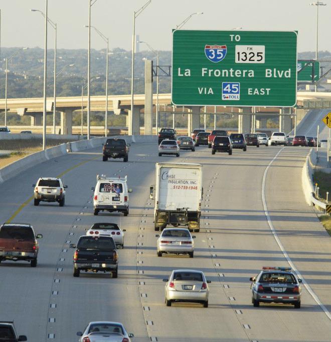


1 LOOP 360 IMPROVEMENT STUDY Overview and Preliminary Analysis August
2 STUDY PROCESS 2

3 Study Background Loop 360 serves a wide range of users, including residents, businesses, bicyclists, and commuters In 2014, Loop 360 was listed as the 98 th most congested roadway in Texas Previous major proposals for Loop 360, including a 2004 proposal to add tolled grade-separated lanes and a 2011 proposal to implement innovative intersections, were generally not well-received by the community, and did not result in significant changes Minor improvements were made since 2011, but more short term fixes are needed and we lack a future vision for the corridor The current Loop 360 study will actively engage the community throughout the process 3

4 Loop 360 in the Region Loop 360 is part of a network of critical roadways in the Austin region Other major north/south roadways (MoPac, I-35) serving the central and western portions of the region are highly congested, and are currently undergoing significant upgrades Loop 360 is the next north/south roadway requiring improvements to help manage congestion in the region 4

5 Loop 360 Improvement Study Process 5


6 Stakeholder Engagement Who are the Loop 360 stakeholders? Nearby residents, businesses, homeowners associations, commuters, bicyclists, pedestrians, environmentalists, and others How are stakeholders invited to participate? Online survey Submitting comments Requesting meetings with the study team Section working groups Other (kiosks in public places, at public meetings for other transportation projects, etc.) 6
7 NEED FOR IMPROVEMENTS 7
")
 A/B Light")

8 Existing Traffic Conditions The Loop 360 project team is reviewing: Traffic volumes Levels of Service (LOS) for intersections along the corridor Travel times Travel speeds Levels of Service (LOS) A/B Light traffic, minimal delay C/D Moderate congestion, moderate delay Example E/F Heavy congestion, considerable delay 8
9 Southbound Northbound Existing Travel Times and Speeds: Overall Corridor Peak Time Frame Travel Time (hr/min) Speed (miles per hour) AM Peak: Average (6:15-9:15 AM) AM Peak: Worst (8:15 AM) PM Peak: Average (4-7 PM) PM Peak: Worst (4:30 PM) AM Peak: Average (6:30-8:45 AM) AM Peak: Worst (7:35 AM) PM Peak: Average (3:30-6:30 PM) PM Peak: Worst (4:45 PM) 1:
10 Existing LOS: North MoPac to Courtyard Drive Intersection AM Peak PM Peak Loop 360 / North MoPac NB B D Loop 360 / North MoPac SB C F Loop 360 / Stonelake Blvd C D Loop 360/ Gateway Shopping Plaza B C Loop 360/ Research Boulevard NB D F Loop 360/Research Boulevard SB D E Loop 360 / Great Hills Drive F E Loop 360 / Spicewood Springs F F Loop 360 / Old Spicewood Springs D E Loop 360 / Lakewood Drive E F Loop 360 NB / RM 2222 E F Loop 360 SB / RM 2222 C C Loop 360/ Courtyard Drive D F 10
11 Existing LOS: Cedar Street to Barton Creek Plaza Intersection AM Peak PM Peak Loop 360 / Cedar Street A B Loop 360 / West Lake Drive E F Loop 360 / Pascal Lane B B Loop 360 NB / RM 2244 E F Loop 360 SB / RM 2244 F F Loop 360 / Las Cimas Parkway D D Loop 360/ Lost Creek Blvd E D Loop 360/ Westbank Drive D E Loop 360 / Walsh Tarlton Lane C C Loop 360 / Barton Creek Mall A C Loop 360 / South MoPac SB D D Loop 360/ South MoPac NB F D Loop 360/ Barton Creek Plaza B B 11

12 Input Received from Loop 360 Public Survey The Loop 360 online survey has been active since March 2015 A total of 3,027 survey responses have been received as of August 04 Survey responses came from 84 unique zip codes, while approximately 55 percent of responses came from the five zip codes directly surrounding the project area 12
13 How are Problems Perceived Along Loop 360? Most Significant Problem 1 Rank the order of each of the problems listed below. Average Score* Percentage Who Ranked this #1 1 - Overall traffic congestion along the corridor % 2 - Traffic backups at specific Loop 360 intersections % 3 - Difficulty turning/merging onto Loop 360 mainlanes 4.1 3% 4 - Difficulty/delay turning onto cross streets from Loop % 5 - Overall safety along the corridor 5.1 5% 6 - Difficulty crossing Loop % 7 - Conflicts between auto and bicycle/pedestrian traffic 5.6 6% 8 - Difficulty accessing businesses or residences from Loop % * Average score determined by multiplying the score value by the number of people who selected that score, and dividing by total responses Least Significant Problem 8 13
14 Perceived Problems and Solutions along Loop 360 Long travel times on Loop 360 affect over 90 percent of respondents who live along the corridor, while less than 3 percent say traffic does not impact their neighborhood. Almost 50 percent of respondents who live along the corridor cite neighborhood cutthrough traffic as an issue, and over 30 percent note increased traffic violations and safety issues due to congestion. Almost 70 percent of respondents state that providing faster, more reliable travel times on Loop 360 should be the top priority for corridor improvements. Of possible options to improve mobility, a majority of respondents feel that eliminating traffic signals and building over/underpasses at intersections would be the most effective solution. Intersection improvements that reduce travel time along Loop 360 and adding more lanes to Loop 360 are the next two most popular options. Many respondents also note a desire to maintain the visual character of the corridor, improve the traffic signal timing, and separate the bicycle and pedestrian facilities from the main vehicle lanes. To participate in the public survey, click here. More detail on public survey responses to date can be found here. 14
15 SCENARIO DEVELOPMENT AND ANALYSIS 15

16 Scenario Development What is a scenario? A scenario assesses what the possible outcomes would be if a certain set of improvements, such as intersection improvements, additional lanes, and/or removing traffic signals, are implemented How are the scenarios being developed? Data analysis of projected traffic volumes, LOS, travel times Stakeholder input Best practices from across the state and nation 16
17 Initial Scenarios to be Considered 1 No Build (Do Nothing) No improvements other than those in regional transportation plan (out to 2035) and traffic signal optimization Included as a baseline against which all scenarios are compared 2 Intersection Improvements Signal timing, turn lanes, intersection design changes, etc. 3 Two Additional Lanes with Traffic Signals Maintain existing signalized intersections and add one lane in each direction Intersection improvements evaluated in Scenario 2 would be included 4 Traffic Signals Removed on Mainlanes Exchange existing signalized intersections for grade-separated over/underpasses Additional lanes would be included if necessary to meet traffic demand 5 Two or Four Additional Tolled/HOV/Transit Lanes Maintain four existing non-tolled lanes with signalized intersections Add two-four additional unsignalized tolled/hov/transit lanes with over/underpasses 17

18 How Will the Scenarios be Evaluated? Mobility: How well does each potential scenario address congestion? Safety: How will each scenario address safety issues for cars, bicycles and pedestrians? Are some scenarios safer than others? Cost: How much funding will be required to implement each scenario? Feasibility: How easily can each scenario be implemented, and how long will they take to complete? Aesthetics/Visual and Other Impacts: How will each scenario impact the surrounding area in terms of aesthetics, right-of-way, environmental, etc.? Longevity: How far into the future will each scenario effectively handle mobility needs along the corridor? 18
19 SCENARIO 1: NO BUILD (DO NOTHING) 19
 traffic model, which also includes forecasted population/employment growth to show predicted 2035 traffic patterns No significant")
20 No Build Scenario Analysis The project team developed overall projected traffic volumes for 2035 based on traffic counts collected in late 2014/early 2015 The projected traffic volumes were input into the Capital Area Metropolitan Planning Organization s (CAMPO s) traffic model, which also includes forecasted population/employment growth to show predicted 2035 traffic patterns No significant improvements to Loop 360 were included in the model since none are currently planned or included in CAMPO s Regional Transportation Plan The No Build scenario shows possible outcomes by 2035 if recent growth patterns continue and no significant Loop 360 improvements are implemented 20
21 Existing vs No Build LOS: North MoPac to Courtyard Drive Intersection Existing 2035 AM Peak PM Peak AM Peak PM Peak Loop 360 / North MoPac NB B D C F Loop 360 / North MoPac SB C F D F Loop 360 / Stonelake Blvd C D C E Loop 360/ Gateway Shopping Plaza B C A C Loop 360/ Research Boulevard NB D F D F Loop 360/Research Boulevard SB D E F F Loop 360 / Great Hills Drive F E F F Loop 360 / Spicewood Springs F F F F Loop 360 / Old Spicewood Springs D E F F Loop 360 / Lakewood Drive E F F F Loop 360 NB / RM 2222 E F F F Loop 360 SB / RM 2222 C C D D Loop 360/ Courtyard Drive D F F F 21
22 Existing vs No Build LOS: Cedar Street to Barton Creek Plaza Intersection Existing 2035 AM Peak PM Peak AM Peak PM Peak Loop 360 / Cedar Street A B D D Loop 360 / West Lake Drive E F F F Loop 360 / Pascal Lane B B C E Loop 360 NB / RM 2244 E F F F Loop 360 SB / RM 2244 F F F F Loop 360 / Las Cimas Parkway D D E F Loop 360/ Lost Creek Blvd E D F F Loop 360/ Westbank Drive D E F F Loop 360 / Walsh Tarlton Lane C C E D Loop 360 / Barton Creek Mall A C C E Loop 360 / South MoPac SB D D E F Loop 360/ South MoPac NB F D F F Loop 360/ Barton Creek Plaza B B D E 22
23 NEXT STEPS 23


24 Next Steps Analysis of Scenarios 2-5 Ongoing public involvement through stakeholder meetings, survey, and comments Scenario refinement and development of draft report outlining short and long-term improvement options 24
25 For More Information More information on the Loop 360 Improvement Study is available at You may also click on the links below to go directly to a specific item: Take the online public survey View the latest public survey response summary View the study fact sheet View frequently asked questions (FAQs) about the study Submit a comment or request a presentation for your organization View project details and schematic on upcoming improvements to Loop 360 between Walsh Tarlton Lane and Barton Creek Plaza 25
RM 620 FEASIBILITY STUDY
 RM 620 FEASIBILITY STUDY Sections 5 & 6 December 7, 2015 STUDY PROCESS Study Purpose and Goals The RM 620 Feasibility Study was launched by the Texas Department of Transportation (TxDOT) to analyze transportation
RM 620 FEASIBILITY STUDY SURVEY RESPONSES
 RM 620 FEASIBILITY STUDY SURVEY RESPONSES as of January 11, 2016 1/11/16 Who is Responding to the RM 620 Feasibility Study Survey? As of January 11, 2016, 2,835 survey responses have been received Approximately
Proposed Action, Purpose and Need Technical Memorandum
 Proposed Action, Purpose and Need Technical Memorandum MoPac (State Loop 1) Intersections, Austin District From North of Slaughter Lane to South of La Crosse Avenue CSJ: 3136-01-015 Travis County, Texas
MoPac South: Impact on Cesar Chavez Street and the Downtown Network
 MoPac South: Impact on Cesar Chavez Street and the Downtown Network Prepared by: The University of Texas at Austin Center for Transportation Research Prepared for: Central Texas Regional Mobility Authority
Northbound San Jose Avenue & I-280 Off-Ramp Road Diet Pilot Project
 Project Overview Fed by a two-lane Interstate-280 (I-280) off-ramp, high vehicular volumes and speeds are longstanding issues along San Jose Avenue. Residents in the surrounding neighborhoods have expressed
2014/2015 BIKE ROUTE PLAN 83 AVENUE PROTECTED BIKE LANE
 About the Project 2014/2015 BIKE ROUTE PLAN The City of Edmonton is planning a major bike route on the south side of Edmonton. This bike route is one part of a plan to provide citizens with transportation
North Shore Transportation Improvement Strategy
 North Shore Transportation Improvement Strategy Preliminary, Near-term Recommendation 2016 April Transportation Improvement Strategy (TIS) Comprehensive and Analytical A multi-modal transportation strategy
Figure 1: East West Connector Alignment Alternatives Concept Drawing
 Page 2 of 9 Figure 1: East West Connector Alignment Alternatives Concept Drawing The Montebello Drive extension will run north south and connect Wilsonville Road to the Boones Ferry Road to Brown Road
Lee s Summit Road Improvement Study Public Open House June 7, 2007 Summary of Comment Card Responses
 Lee s Summit Road Improvement Study Public Open House June 7, 2007 Summary of Comment Card Responses Introduction At the Lee s Summit Road Improvement Study Public Open House held Thursday, June 7, 2007
Thank you for attending
 Improving mobility safety comfort WELCOME Thank you for attending The purpose of this meeting is to: Learn about the project Prioritize potential walking and biking improvements on Snelling Ave Gather
Dr. M.L. King, Jr. Street North Complete Streets Resurfacing Opportunities HOUSING, LAND USE, AND TRANSPORTATION COMMITTEE MARCH 22, 2018
 Dr. M.L. King, Jr. Street North Complete Streets Resurfacing Opportunities HOUSING, LAND USE, AND TRANSPORTATION COMMITTEE MARCH 22, 2018 What s Happening The City plans to mill and resurface Dr. M.L.
Brian McHugh, Buckhead Community Improvement District. SUBJECT: Wieuca Road at Phipps Boulevard Intersection Improvements Project
 MEMO TO: FROM: Brian McHugh, Buckhead Community Improvement District Jagan Kaja, AICP, WSP Parsons Brinckerhoff SUBJECT: Wieuca Road at Phipps Boulevard Intersection Improvements Project DATE: October
5858 N COLLEGE, LLC N College Avenue Traffic Impact Study
 5858 N COLLEGE, LLC nue Traffic Impact Study August 22, 2016 Contents Traffic Impact Study Page Preparer Qualifications... 1 Introduction... 2 Existing Roadway Conditions... 5 Existing Traffic Conditions...
Highway 111 Corridor Study
 Highway 111 Corridor Study June, 2009 LINCOLN CO. HWY 111 CORRIDOR STUDY Draft Study Tea, South Dakota Prepared for City of Tea Sioux Falls Metropolitan Planning Organization Prepared by HDR Engineering,
Chapter 4 Traffic Analysis
 Chapter 4 Traffic Analysis PURPOSE The traffic analysis component of the K-68 Corridor Management Plan incorporates information on the existing transportation network, such as traffic volumes and intersection
Appendix C. NORTH METRO STATION AREA TRAFFIC IMPACT STATEMENT 88th Avenue Station
 Appendix C NORTH METRO STATION AREA TRAFFIC IMPACT STATEMENT 88th Avenue Station Prepared for: Regional Transportation Department and URS Corporation as part of the North Metro EIS David Evans and Associates,
Waterford Lakes Small Area Study
 Waterford Lakes Small Area Study Existing Traffic Conditions PREPARED FOR: ORANGE COUNTY PUBLIC WORKS DEPARTMENT TRAFFIC ENGINEERING DIVISION ORLANDO, FLORIDA PREPARED WITH: INWOOD CONSULTING ENGINEERS
Welcome. If you have any questions or comments on the project, please contact:
 Welcome This drop-in public open house is intended to provide information about the Bay Street bike lanes project. This project proposes a dedicated cycling facility along Bay Street between Aberdeen Avenue
Subject: Solberg Avenue / I-229 Grade Separation: Traffic Analysis
 MEMORANDUM Transportation Bill Troe, AICP Jason Carbee, AICP 12120 Shamrock Plaza Suite 300 Omaha, NE 68154 (402) 334-8181 (402) 334-1984 (Fax) To: Project File Date: Subject: Solberg Avenue / I-229 Grade
Measuring the Distribution and Costs of Congestion. Tim Lomax Texas Transportation Institute
 Measuring the Distribution and Costs of Congestion Tim Lomax Texas Transportation Institute http://mobility.tamu.edu The Congestion Measurement Story Travel time, variations, compare to goals WHAT? WHY?
REVIEW OF LOCAL TRAFFIC FLOW / LONG RANGE PLANNING SOLUTIONS STUDY
 ITEM Town of Atherton TRANSPORTATION COMMITTEE STAFF REPORT TO: FROM: MEMBERS OF THE COMMITTEE ROBERT OVADIA, PUBLIC WORKS DIRECTOR DATE: FEBRUARY 12, 2019 SUBJECT: REVIEW OF LOCAL TRAFFIC FLOW / LONG
Welcome! San Jose Avenue Open House August 25, 2015
 Welcome! San Jose Avenue Open House August 25, 2015 Vision Zero The City and County of San Francisco adopted Vision Zero San Francisco Vision Zero High Injury Network as a policy in 2014, committing an
HIGHBURY AVENUE/HAMILTON ROAD INTERSECTION IMPROVEMENTS PUBLIC INFORMATION CENTRE 1 MAY 14, 2015
 HIGHBURY AVENUE/HAMILTON ROAD INTERSECTION IMPROVEMENTS Municipal Class Environmental Assessment PUBLIC INFORMATION CENTRE 1 MAY 14, 2015 ACCESSIBILITY Under the Accessibility Standards 2015 for Customer
STUDY LOCATION February 26, 2015
 STUDY LOCATION ANTICIPATED TIMELINE The environmental review, consultation, and other actions required by applicable Federal environmental laws for this project are being, or have been, carried-out by
WELCOME Public Information Centre
 WELCOME Public Information Centre Fernforest Drive Brampton Soccer Centre Community Room #2 Tuesday January 19, 2016 6:30 p.m.to 9:00 p.m. Please sign in Neighbourhood Traffic Calming Guide Background
2014/2015 BIKE ROUTE PLAN 83 AVENUE PROTECTED BIKE LANE
 About the Project The City of Edmonton is planning a major bike route on the southside of Edmonton. The Strathcona Bike Route will connect the communities of Strathcona, Garneau and the University area,
Project Description Form 8EE
 Project Description Form 8EE Basic Project Information Submitting Jurisdiction/Agency: Town of Dumfries Project Title: Route 1 (Fraley Blvd) Widening: Brady's Hill Road to Dumfries Road Project Location:
CHIEF PEGUIS TRAIL EXTENSION WEST
 1 PRELIMINARY DESIGN OF THE CHIEF PEGUIS TRAIL EXTENSION WEST Public Information Session June 6, 2017 Welcome 1 Thank you for attending today s public information session. The following boards provide
Arterial Management Plan for US Route 250 and State Route 623
 Arterial Management Plan for US Route 250 and State Route 623 June 25, 2014 Brad Shelton, AICP Access Management and Traffic Impact Analysis Programs Manager Transportation and Mobility Planning Division
WEST AND SOUTH WEST RING ROAD DOWNSTREAM TRAFFIC IMPACTS
 Page 1 of 9 EXECUTIVE SUMMARY Alberta Transportation ( AT ) is preparing to construct the final sections of the Calgary Ring Road. This includes the South West Ring Road ( SWRR ) (from Lott Creek Blvd
Arterial Transitway Corridors Study. Ave
 Arterial Transitway Corridors Study Ave January 2012 Arterial Transitway Corridors Study Overview Corridor Features and Demographics 11 study corridors, 95 route miles 86,000 daily rides and half of existing
Santa Clara I-280 CORRIDOR STUDY
 Santa Clara I-280 CORRIDOR STUDY OCTOBER 2017 PREPARED BY: 1.1 Background The I-280 Corridor Study within Santa Clara County is a high-level highway planning study led by the Santa Clara VTA, in partnership
Public Information Centre
 WELCOME Public Information Centre Father Tobin Road Lougheed Middle School - Library Wednesday November 7, 2012 7:00 p.m.to 9:00 p.m. Please sign in Neighbourhood Traffic Calming Guide Background The City
1609 E. FRANKLIN STREET HOTEL TRAFFIC IMPACT STUDY EXECUTIVE SUMMARY
 1609 E. FRANKLIN STREET HOTEL TRAFFIC IMPACT STUDY EXECUTIVE SUMMARY Prepared for: The Town of Chapel Hill Public Works Department Traffic Engineering Division Prepared by: HNTB North Carolina, PC 343
FY STIP. Austin District. November Quarterly Revisions HIGHWAY STATEWIDE TRANSPORTATION IMPROVEMENT PROGRAM
 FY 2011-2014 STIP STATEWIDE TRANSPORTATION IMPROVEMENT PROGRAM HIGHWAY Austin District November Quarterly Revisions November 2011 FY 2011-2014 Transportation Improvement Program Amendments October 10,
Short-Term Enhancements Improvements to keep Austin moving. MetroRapid
 Short-Term Enhancements Improvements to keep Austin moving Long-Term Investments Projects to support our future Mobility Hubs MetroRapid MetroRail MetroExpress Commuters Connectors Circulators Project
3.0 Future Conditions
 3.0 Future Conditions In order to be able to recommend appropriate improvements to the transportation system of the Town, it is important to first understand the nature and volume of traffic that is expected
SANTA MONICA BOULEVARD CORRIDOR
 CIRCULATION ELEMENT WHITE PAPER NO. 3 SANTA MONICA BOULEVARD CORRIDOR INTRODUCTION From the 1930s to the beginning of Los Angeles freeway era, Santa Monica Boulevard, (previously Route 66, the Beverly
APPENDIXB. Traffic Operations Technical Memorandum
 APPENDIXB Traffic Operations Technical Memorandum Environmental Assessment - Lincoln County, SD 85 th Street: Sundowner Avenue to Louise Avenue November 2017 MEMORANDUM Transportation Jim Kollbaum, PE
Tulsa Metropolitan Area LONG RANGE TRANSPORTATION PLAN
 Tulsa Metropolitan Area LONG RANGE TRANSPORTATION PLAN Indian Nations Council of Governments August 2005 CONTACTING INCOG In developing the Destination 2030 Long Range Transportation Plan, INCOG s Transportation
5.0 Roadway System Plan
 Southwest Boise Transportation Study Page 16 5.0 Roadway System Plan The Roadway System Plan outlines roadway improvements in the Initial Study Area. It forecasts future deficiencies on the arterial system,
Highway 217 Corridor Study. Phase I Overview Report
 Highway 217 Corridor Study Phase I Overview Report November 3, 24 BACKGROUND AND OVERVIEW Study purpose The Highway 217 Corridor Study is developing multi-modal transportation solutions for traffic problems
WALKNBIKE DRAFT PLAN NASHVILLE, TENNESSEE EXECUTIVE SUMMARY NASHVILLE, TENNESSEE
 NASHVILLE, TENNESSEE EXECUTIVE SUMMARY Executive Summary A world-class multi-modal transportation system is essential to a vibrant city and better quality of life. -Mayor Barry The WalknBike plan aims
Terwillegar Drive Expressway Draft Concept Plan
 Terwillegar Drive Expressway Draft Concept Plan Anthony Henday Drive to Whitemud Drive November 28 5:00-8:00 p.m. December 1 10:00 a.m. - 3:00 p.m. Let s Talk Today you can: Learn about the new direction
4.0 TRANSPORTATION SYSTEMS
 Transportation Systems 4.0 TRANSPORTATION SYSTEMS This chapter examines the impacts of the Central Corridor Extension on existing roadways and traffic operations and discusses the transit service, operations,
TABLE OF CONTENTS. Executive Summary
 Executive Summary Background... ES-1 Pedestrian Network... ES-2 Bikeway Network... ES-2 Collision History... ES-2 Public Input... ES-4 Conclusions and Recommendations... ES-4 1. Introduction and Setting
Project Report. South Kirkwood Road Traffic Study. Meadows Place, TX October 9, 2015
 Meadows Place, TX October 9, 2015 Contents 1 Introduction... 1 2 Data Collection... 1 3 Existing Roadway Network... 2 4 Traffic Volume Development... 2 5 Warrant Analysis... 3 6 Traffic Control Alternative
Los Altos Hills Town Council - June 18, 2015 Palo Alto City Council June 22, AGENDA ITEM #2.B Presentation
 Los Altos Hills Town Council - June 18, 2015 Palo Alto City Council June 22, 2015 AGENDA ITEM #2.B Presentation Previous Presentations Los Altos Hills Town Council in May 2014 and February 2015 Palo Alto
Traffic Circulation Study for Neighborhood Southwest of Mockingbird Lane and Airline Road, Highland Park, Texas
 ARIZONA TEXAS NEW MEXICO OKLAHOMA February 13, 2015 Mr. Meran Dadgostar P.E., R.S. Town of Highland Park 4700 Drexel Dr. Highland Park, Texas 75205 Re: Traffic Circulation Study for Neighborhood Southwest
The Bay Bridge Corridor Congestion Study
 Bay Bridge Corridor Congestion Study Tony Bruzzone, Arup TJPA Board Nov 1, 2010 Funded by AC Transit/Federal Transit Administration (FTA) Contracted with the Transbay Joint Powers Authority (TJPA) Stakeholders:
University of Victoria Campus Cycling Plan Terms of Reference. 1.0 Project Description
 University of Victoria Campus Cycling Plan Terms of Reference 1.0 Project Description The Campus Cycling Plan, a first for the University, will provide a comprehensive and coordinated approach to support
Bellevue Downtown Association Downtown Bike Series
 Bellevue Downtown Association Downtown Bike Series Meeting 2 Franz Loewenherz Andreas Piller Kyle Potuzak Chris Long October 26, 2017 Today s Agenda: 1) Meeting Purpose 2) 9/28 Meeting Recap 3) Candidate
WELCOME. Stakeholder Involvement Group Meeting #2 Round Lake Public Works October 24, 2018
 WELCOME Stakeholder Involvement Group Meeting #2 Round Lake Public Works October 24, 2018 MEETING AGENDA 1. Welcome and Introductions 2. Study Progress Update 3. Problem Statement 4. Technical Analysis
Waterford Lakes Small Area Study
 Over the last several years, the Waterford Lakes area has experienced increased congestion due to a substantial increase in residential and commercial development. The current Existing and Future Conditions
Arterial Transitway Corridors Study
 Arterial Transitway Corridors Study February 2012 Arterial Transitway Corridors Study Overview Corridor Features and Demographics 11 study corridors, 95 route miles Routes: 86,000 daily rides and half
Bus Rapid Transit on Silicon Valley s El Camino Real: Working Together to Create a Grand Boulevard Steven Fisher
 Bus Rapid Transit on Silicon Valley s El Camino Real: Working Together to Create a Grand Boulevard Steven Fisher Senior Transportation Planner Santa Clara Valley Transportation Authority San Jose, CA How
Preliminary Transportation Analysis
 Preliminary Transportation Analysis Goals of a Robust, Multimodal Transportation Network Safe Accessible/Connected Efficient Comfortable Context-Sensitive Motor Vehicle: Continue to analyze the data to
MEMORANDUM. Charlotte Fleetwood, Transportation Planner
 MEMORANDUM Date: Updated August 22, 2017 To: Organization: Charlotte Fleetwood, Transportation Planner Boston Transportation Department From: Jason DeGray, P.E., PTOE, Regional Director of Engineering
Click to edit Master title style
 Route N Study Community Advisory Group (CAG) Meeting #2 December 12, 2018 Click Agenda to edit Master title style Introductions Recap of the CAG Meeting #1 and Public Meeting #1 Purpose & Need Review Review
Traffic Impact Study WestBranch Residential Development Davidson, NC March 2016
 Traffic Impact Study WestBranch Residential Development Davidson, NC March 216 TRAFFIC IMPACT STUDY FOR THE WestBranch Residential Development LOCATED IN DAVIDSON, NC Prepared For: Lennar Carolinas, LLC
183 North Mobility Project Community Survey Report
 183 North Mobility Project Community Survey Report Conducted in conjunction with the Open House #3 March, 1, 8 p.m. Westwood High School During the Open House and concurrent Virtual Open House, the study
APPENDIX F SUPPLEMENTAL TRAFFIC DATA
 APPENDIX F SUPPLEMENTAL TRAFFIC DATA Environmental and Planning Consultants 440 Park Avenue South 7th Floor New York, NY 10016 tel: 212 696-0670 fax: 212 213-3191 www.akrf.com Draft Memorandum To: Michael
Key objectives of the survey were to gain a better understanding of:
 3 COMMUNITY INPUT Community input is an essential part of corridor studies. For the SR 87 corridor study, VTA staff conducted an extensive online survey of people living and commuting along the corridor.
Southwest Bus Rapid Transit (SW BRT) Functional Planning Study - Executive Summary January 19 LPT ATTACHMENT 2.
 Functional Planning Study - Executive Summary January 19 LPT ATTACHMENT 2.") Southwest Bus Rapid Transit (SW BRT) Functional Planning Study - Executive Summary 2011 January 19 1 of 19 Introduction This executive summary presents the results of the Southwest Bus Rapid Transit (SW
Southwest Bus Rapid Transit (SW BRT) Functional Planning Study - Executive Summary 2011 January 19 1 of 19 Introduction This executive summary presents the results of the Southwest Bus Rapid Transit (SW
Memorandum. Fund Allocation Fund Programming Policy/Legislation Plan/Study Capital Project Oversight/Delivery Budget/Finance Contract/Agreement Other:
 Memorandum Date: November 20, 2017 To: Transportation Authority Board From: Eric Cordoba Deputy Director Capital Projects Subject: 12/5/17 Board Meeting: San Francisco Freeway Corridor Management Study
1. What is the Doran Street and Broadway/Brazil Grade Separation Project (Project)?
?") 1. What is the Doran Street and Broadway/Brazil Grade Separation Project (Project)? The Los Angeles County Metropolitan Transportation Authority (Metro) is evaluating the development of a grade separation
1. What is the Doran Street and Broadway/Brazil Grade Separation Project (Project)? The Los Angeles County Metropolitan Transportation Authority (Metro) is evaluating the development of a grade separation
Offset Single Point Interchange I-25 at Rio Bravo Boulevard Albuquerque, New Mexico
 Offset Single Point Interchange I-25 at Rio Bravo Boulevard Albuquerque, New Mexico INSTITUTE OF TRANSPORTATION ENGINEERS 2016 WESTERN DISTRICT MEETING JULY 11, 2016 7/11/2016 1 Project Vicinity Map 7/11/2016
HARRISON STREET/OAKLAND AVENUE COMMUNITY TRANSPORTATION PLAN
 HARRISON STREET/OAKLAND AVENUE Community Workshop #4: Draft Plan Review December 3, 2009 D E S I G N, C O M M U N I T Y & E N V I R O N M E N T INTRODUCTIONS Key Project Staff: Alisa Shen, Project Manager,
Purpose and Need. Chapter Introduction. 2.2 Project Purpose and Need Project Purpose Project Need
 Chapter 2 Purpose and Need 2.1 Introduction The El Camino Real Bus Rapid Transit (BRT) Project (Project) would make transit and other transportation improvements along a 17.6-mile segment of the El Camino
The current document is revised based on the comments received on:
 General Overview 1 Introduction Over the last several years, the Waterford Lakes area has experienced increased congestion due to a substantial increase in residential and commercial development. The current
I-395 Express Lanes Northern Extension Project Crystal City Civic Association September 21, 2016
 I-395 Express Lanes Northern Extension Project Crystal City Civic Association September 21, 2016 Mike Snare, PE, Project Manager Virginia Department of Transportation GEC Michelle Holland, Megaprojects
MASTER BICYCLE AND PEDESTRIAN PLAN
 VILLAGE OF NORTHBROOK MASTER BICYCLE AND PEDESTRIAN PLAN DRAFT PLAN OPEN HOUSE May 2, 2018 AGENDA 1. Community Engagement 2. Vision and Goals 3. General Structure of Plan 4. Recommendations Overview 5.
3 TRAFFIC CONTROL SIGNAL TIMING AND SYNCHRONIZATION
 Report No. 8 of the Transportation Services Committee Regional Council Meeting of October 20, 2011 3 TRAFFIC CONTROL SIGNAL TIMING AND SYNCHRONIZATION The Transportation Services Committee recommends:
Feasibility Study of Pedestrian Crossings Along Route 7, East of Cascades Parkway and West of Dranesville Road. October 3, 2017
 Feasibility Study of Pedestrian Crossings Along Route 7, East of Cascades Parkway and West of Dranesville Road October 3, 2017 Study Area (area within a ¼-mile radius of the study intersections) Route
Protected Bike Lanes in San Francisco Mike Sallaberry SFMTA NACTO Workshop - Chicago IL
 Protected Bike Lanes in San Francisco Mike Sallaberry SFMTA 10 14 2011 NACTO Workshop - Chicago IL San Francisco 2 nd Highest Density in the U.S. 47 square miles Mild Climate Market Population ~810,000
RM 620 Corridor Improvement Study. US 183 North to SH 71 West in Travis and Williamson Counties
 RM 620 Corridor Improvement Study US 183 North to SH 71 West in Travis and Williamson Counties February 2017 Executive Summary Background Ranch-to-Market 620 from State Highway 71 to United States Highway
The specific activities consisted of:
 Mount Olive Development Corporation (MODCO) Speak Up Broward Program for Empowering People Dates of program: May 2014 August 2014 Communities Served: 33311, 33313, and 33301 Zip Code Areas Target Audience:
Appendix B: Forecasting and Traffic Operations Analysis Framework Document
 Existing Conditions Report - Appendix Appendix B: Forecasting and Traffic Operations Analysis Framework Document This document defines the methodology and assumptions that will be used in the traffic forecasting
TRAFFIC IMPACT ANALYSIS
 TRAFFIC IMPACT ANALYSIS FOR THE CHAMPAIGN UNIT#4 SCHOOL DISTRICT PROPOSED HIGH SCHOOL (SPALDING PARK SITE) IN THE CITY OF CHAMPAIGN Final Report Champaign Urbana Urbanized Area Transportation Study 6/24/2014
Mineral Avenue Corridor Assessment. ITE 2017 Western District Annual Meeting San Diego, CA June 21 st
 Mineral Avenue Corridor Assessment ITE 2017 Western District Annual Meeting San Diego, CA June 21 st Biography - Aaron Heumann, PE, PTOE Currently City of Littleton Transportation Engineering Manager 24
City of Wilsonville 5 th Street to Kinsman Road Extension Project
 City of Wilsonville 5 th Street to Kinsman Road Walking Tour & Neighborhood Workshop Summary Report Public Outreach Overview On July 18 th, 2017, the City of Wilsonville hosted a neighborhood walking tour
FINAL DESIGN TRAFFIC TECHNICAL MEMORANDUM
 FINAL DESIGN TRAFFIC TECHNICAL MEMORANDUM July 2014 FINAL (SR 43) Project Development and Environment Study From State Road 60 (Adamo Drive) to I-4 (SR 400) Hillsborough County, Florida Work Program Item
BETHEL ROAD AND SEDGWICK ROAD CORRIDOR STUDY
 DRAFT PLAN City Council Meeting August 14, 2017 STUDY AREA Sedgwick Corridor State Route 160, principal arterial with Class 3 access management designation, commuter and freight route, connection to SR
MEMORANDUM INTRODUCTION/PURPOSE/OVERALL FINDINGS
 MEMORANDUM Date: To: From: Subject: Steve, City of Tacoma Dan Grayuski and Will Lisska, Fehr & Peers Schuster Corridor Trail Project SE12-0265.00 INTRODUCTION/PURPOSE/OVERALL FINDINGS The City of Tacoma
CITY OF WEST LAKE HILLS. Forest View Neighborhood Traffic Calming Study
 CITY OF WEST LAKE HILLS 901 South Mopac Expressway Building V, Suite 220 Austin, Texas 78746 Texas P.E. Firm Registration No. F-929 Klotz Associates Final Report Submittal: March 20, 2015 Revised Final
Highway 49, Highway 351 and Highway 91 Improvements Feasibility Study Craighead County
 Highway 49, Highway 351 and Highway 91 Improvements Feasibility Study Craighead County Executive Summary March 2015 Highway 49, Highway 351 and Highway 91 Improvements Feasibility Study Craighead County
1.0 INTRODUCTION 1.1 PURPOSE OF THIS REPORT
 1.0 INTRODUCTION This chapter provides an overview of the purpose, authorization and focus of this Recirculated Draft Environmental Impact Report (EIR), an identification of the Lead Agency, an outline
Giles Run Connector Road
 Giles Run Connector Road Laurel Hill Adaptive Reuse Area to Laurel Crest Drive South County Federation Meeting June 14, 2016 History Connector road included in the Laurel Hill Comprehensive Plan amendment
Bus Rapid Transit Plans
 Twin Cities Region Bus Rapid Transit Plans ULI Minnesota Workshop Connecting Bus Rapid Transit to the Community December 15, 2009 John Levin Director of Service Development Metro Transit Metropolitan Area
THIS PAGE LEFT BLANK INTENTIONALLY
 GA SR 25 Spur at Canal Road Transportation Impact Analysis PREPARED FOR GLYNN COUNTY, GEORGIA 1725 Reynolds Street, Suite 300 Brunswick, Georgia 31520 PREPARED BY 217 Arrowhead Boulevard Suite 26 Jonesboro,
Citizen Advisory Group Meeting #8 May 5, Welcome. Today s meeting will focus on: Land Use & Transportation CHARLOTTEPLANNING.
 Citizen Advisory Group Meeting #8 May 5, 2010 Welcome. Today s meeting will focus on: Land Use & Transportation CHARLOTTEPLANNING.ORG Meeting Agenda Handouts: o Meeting Agenda o Summary of East Seventh
Project Description Form 6V
 Project Description Form 6V Basic Project Information Submitting Jurisdiction/Agency: Prince William County Project Title: Route 15 Widening: Route 55 to south of RR tracks & Construct RR Overpass Project
Ravenswood Avenue Railroad Crossing Project Community Outreach Meeting Presentation May 2, Ravenswood Avenue Railroad Crossing Project
 Ravenswood Avenue Railroad Crossing Project Community Outreach Meeting Presentation May 2, 2016 Agenda Welcome & Introduction Project Background & Purpose Project Overview Small Group Breakouts / Reporting
EL CAMINO REAL BUS RAPID TRANSIT (BRT) PROJECT
 PROJECT") Agenda Item #4.2 EL CAMINO REAL BUS RAPID TRANSIT (BRT) PROJECT VTA BOARD WORKSHOP MAY 1, 2015 ABOUT THIS PRESENTATION CONTEXT Existing conditions and planning for growth WHAT IS THE PROJECT? Project alternatives
Agenda Item #4.2 EL CAMINO REAL BUS RAPID TRANSIT (BRT) PROJECT VTA BOARD WORKSHOP MAY 1, 2015 ABOUT THIS PRESENTATION CONTEXT Existing conditions and planning for growth WHAT IS THE PROJECT? Project alternatives
Kansas City Area Transportation Authority. Downtown Transit Improvement Vision 2/11/15
 Kansas City Area Transportation Authority Downtown Transit Improvement Vision 2/11/15 Today s Meetings Downtown Transit Vision Long Term Vision for Downtown Bus Service Priorities for Short Term Implementation
US 41 COMPLETE STREETS CORRIDOR PLANNING STUDY from University Parkway to Whitfield Avenue
 41 US 41 COMPLETE STREETS CORRIDOR PLANNING STUDY from University Parkway to Whitfield Avenue EXECUTIVE SUMMARY DRAFT FEBRUARY 2019 Project Overview The US 41 Complete Streets Corridor Planning Study,
TRANSPORTATION ANALYSIS REPORT US Route 6 Huron, Erie County, Ohio
 TRANSPORTATION ANALYSIS REPORT US Route 6 Huron, Erie County, Ohio December 12, 2012 Prepared for: The City of Huron 417 Main Huron, OH 44839 Providing Practical Experience Technical Excellence and Client
Bikeway action plan. Bicycle Friendly Community Workshop March 5, 2007 Rochester, MN
 Bikeway action plan Summary The was held on March 5, 2007 at the Rochester Mayo Civic Center. The workshop was hosted by Rochester-Olmsted County Planning Department in collaboration with the League of
MOBILITY WORKSHOP. Joint City Council and Transportation Commission May 5, 2014
 MOBILITY WORKSHOP Joint City Council and Transportation Commission May 5, 2014 Review of General Plan M-1 Develop world-class transit system M-3 Maintain/enhance pedestrian-oriented City M-4 Create comprehensive
Presentation of Staff Draft March 18, 2013 COUNTYWIDE TRANSIT CORRIDORS FUNCTIONAL MASTER PLAN
 Presentation of Staff Draft March 18, 2013 COUNTYWIDE TRANSIT CORRIDORS FUNCTIONAL MASTER PLAN Public Outreach Fall 2011: Two community meetings/open houses Fall 2012: Three community meetings/open houses